
Mississippi River
Encyclopedia
The Mississippi River is the largest river system in North America
. Flowing entirely in the United States
, this river rises in western Minnesota
and meander
s slowly southwards for 2530 miles (4,071.6 km) to the Mississippi River Delta
at the Gulf of Mexico
. With its many tributaries
, the Mississippi's watershed
drains all or parts of 31 U.S. state
s between the Rocky
and Appalachian Mountains
and even reaches into southern Canada
. The Mississippi ranks fourth longest and tenth largest among the world's rivers.
Native American
s lived along the Mississippi and its tributaries. Most were hunter-gatherer
s or herders, but some such as the Mound builders formed prolific agricultural societies. The arrival of Europe
ans in the 1500s forever changed the native way of life as first explorers, then settlers, ventured into the basin in increasing numbers. The river served first as barrier – forming borders for New Spain
, New France
, and the early United States – then as vital transportation artery and communications link. In the 19th century, during the height of Manifest Destiny
, the Mississippi and several western tributaries, most notably the Missouri
, formed pathways for pioneers partaking in the western expansion of the United States.
Formed from thick layers of this river's silt deposits, the Mississippi River Valley is one of the most fertile agricultural
regions of the country and as a result came the rise of the river's storied steamboat
era. During the American Civil War
, the Mississippi's capture by Union forces marked a turning point towards victory because of this very importance as a route of trade and travel, not least to the Confederacy
. Because of substantial growth of cities, and the larger ships and barge
s that have supplanted riverboats, the decades following the 1900s saw massive engineering works
applied to the river system, such as the often in-combination construction of levee
s, lock
s and dam
s.
Since modern development of the basin began, the Mississippi has also seen its share of pollution and environmental problems – most notably large volumes of agricultural runoff, which has led to the Gulf of Mexico dead zone off the Delta. In recent years, the river has shown a steady shift towards the Atchafalaya River
channel in the Delta; a course change would prove disastrous to seaports such as New Orleans
. A system of dikes and gates has so far held the Mississippi at bay, but due to fluvial
processes the shift becomes more likely each year.
identity, one being the largest branch (by water volume), and the other being the longest branch. Using the largest-branch criterion, the Ohio would be the main branch of the Lower Mississippi, not the Middle and Upper Mississippi. Using the longest-branch criterion, the Middle Mississippi-Missouri-Jefferson-Beaverhead-Red Rock-Hellroaring Creek River would be the main branch. In either of these cases, the Upper Mississippi from St. Louis, Missouri, to Minnesota, despite its name, would not be part of the more significant branch.
While the Missouri River, flowing from the confluence of the Jefferson
, Madison
and Gallatin River
s to the Mississippi, is the longest continuously named river in the United States, the serial combination of Hellroaring Creek and the Red Rock, Beaverhead, Jefferson, Missouri, Middle Mississippi, and Lower Mississippi rivers, considered as one continuous waterway, is the longest river in North America and the third or fourth longest river in the world. Its length of at least 3745 mi (6,027 km) is exceeded only by the Nile, the Amazon, and perhaps the Yangtze River
among the longest rivers in the world. The source of this waterway is at Brower's Spring
, 8800 feet (2,682.2 m) above sea level in southwestern Montana
, along the Continental Divide
outside Yellowstone National Park
.
The unifying name "Great American River" has been suggested for this multiple named waterway.
However, the names "Mississippi River" for the water course from Minnesota to the Gulf of Mexico, "Missouri River" for its major western tributary, and "Ohio River" for its major eastern tributary are so well established that neither reassignment of names nor creation of novel names can be seriously considered as replacements for current usage. Furthermore, the north-south course of the waterway commonly known as the Mississippi River is widely considered a convenient if approximate dividing line between the Eastern, Southern, and Midwestern United States and the Western U.S., as exemplified by the Gateway Arch
in St. Louis and the phrase "Trans-Mississippi", used for example in the name of the 1898 Trans-Mississippi Exposition
held in Omaha, Nebraska
.
along the river is also noteworthy. These various basic geographical aspects of the river in turn underlie its human history and present uses of the waterway and its adjacent lands.
, the Middle Mississippi, and the Lower Mississippi
, with the Upper Mississippi upriver of its confluence with the Missouri River, the Middle Mississippi from there downriver to the Ohio River, and the Lower Mississippi from there downriver to the Gulf of Mexico.
The Mississippi River is known as the Upper Mississippi from its headwaters to its confluence with the Missouri River at St. Louis, Missouri. The Upper Mississippi is divided into two sections:
The source of the Upper Mississippi branch is traditionally accepted as Lake Itasca
, 1475 feet (449.6 m) above sea level in Itasca State Park
in Clearwater County, Minnesota
. The name "Itasca" is a combination of the last four letters of the Latin word for truth (veritas) and the first two letters of the Latin word for head (caput). However, the lake is in turn fed by a number of smaller streams, of which one might be selected as the river's ultimate source.
to St. Louis, Missouri
, the waterway's flow is moderated by 43 dams. Fourteen of these dams are located above Minneapolis in the headwaters region and serve multiple purposes, including power generation and recreation. The remaining 29 dams, beginning in downtown Minneapolis, all contain locks and were constructed to improve commercial navigation of the upper river. Taken as a whole these 43 dams significantly shape the geography and influence the ecology of the upper river. Beginning just below Saint Paul, Minnesota
, and continuing throughout the upper and lower river, the Mississippi is further controlled by thousands of wing dikes that moderate the river's flow in order to maintain an open navigation channel and prevent the river from eroding its banks.
The head of navigation on the Mississippi is the Coon Rapids Dam in Coon Rapids, Minnesota
. Before its construction in 1913, steamboats could occasionally go upstream as far as Saint Cloud, Minnesota, depending on river conditions.
The uppermost lock and dam on the Upper Mississippi River is the Upper St. Anthony Falls Lock and Dam in Minneapolis. Above the dam, the river's elevation is 799 feet (243.5 m). Below the dam, the river's elevation is 750 feet (228.6 m). This 49 feet (14.9 m) drop is the largest of all the Mississippi River locks and dams. The origin of the dramatic drop is a waterfall preserved adjacent to the lock under an apron of concrete. Saint Anthony Falls
is the only true waterfall on the entire Mississippi River. The water elevation continues to drop steeply as it passes through the gorge carved by the waterfall.
The Upper Mississippi features various natural and artificial lakes, with its widest point being Lake Winnibigoshish
, near Grand Rapids, Minnesota
, over 7 miles (11.3 km) across. Also of note is Lake Onalaska
(created by Lock and Dam No. 7
), near La Crosse, Wisconsin
, over 4 miles (6.4 km) wide. On the other hand, Lake Pepin
is natural, formed due to the delta formed by the Chippewa River of Wisconsin as it enters the Upper Mississippi; it is more than 2 miles (3.2 km) wide.
By the time the Upper Mississippi reaches Saint Paul
, Minnesota, below Lock and Dam #1, it has dropped more than half its original elevation and is 687 feet (209.4 m) above sea level. From St. Paul to St. Louis, Missouri, the river elevation falls much more slowly, and is controlled and managed as a series of pools created by 26 locks and dams.
The Upper Mississippi River is joined by the Minnesota River
at Fort Snelling in the Twin Cities; the St. Croix River
near Prescott, Wisconsin
; the Cannon River near Red Wing, Minnesota
; the Black River (Mississippi River), La Crosse River
, and Root River (Minnesota)
in La Crosse, Wisconsin
; the Wisconsin River
in Prairie du Chien, Wisconsin
; the Rock River in the Quad Cities
; the Iowa River
near Wapello, Iowa
; the Skunk River
south of Burlington, Iowa
; and the Des Moines River
in Keokuk, Iowa. Other major tributaries of the Upper Mississippi include the Crow River
in Minnesota, the Chippewa River
in Wisconsin, the Maquoketa River
and the Wapsipinicon River
in Iowa, and the Big Muddy River
, Illinois River
.
The Upper Mississippi is largely a multi-thread stream with many bars
and islands. From its confluence with the St. Croix River downstream to Dubuque, Iowa
, the river is entrenched, with high bedrock bluffs lying on either side. The height of these bluffs decreases to the south of Dubuque, though they are still significant through Savanna, Illinois
. This topography contrasts strongly with the Lower Mississippi, which is a meandering river in a broad, flat area, only rarely flowing alongside a bluff (as at Vicksburg, Mississippi
).
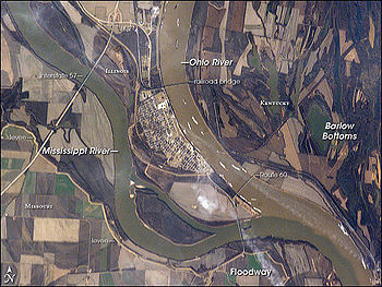
at St. Louis, Missouri, for 190 miles (305.8 km) to its confluence with the Ohio River at Cairo, Illinois.
The Middle Mississippi is a relatively free-flowing river. From St. Louis to the Ohio River confluence, the Middle Mississippi falls a total of 220 feet (67.1 m) over a distance of 180 miles (289.7 km) for an average rate of 1.2 ft/mi. At its confluence with the Ohio River, the Middle Mississippi is 315 feet (96 m) above sea level. Apart from the Missouri River
, and the Kaskaskia River
in Illinois, no major tributaries enter the Middle Mississippi River.
Measured by length, the Middle Mississippi's primary branch is the Missouri River, not the Upper Mississippi, whether or not additional tributaries upstream are considered. Thus, by length, the main branch of the Mississippi River system at St. Louis can be considered to be the Missouri River, rather than the Upper Mississippi. By taking the longer branch at each significant fork, this continuous but multiply named waterway can be identified and measured. One name for it is the Lower & Middle Mississippi-Missouri-Jefferson-Beaverhead-Red Rock-Hellroaring Creek River. The name "Great American River" has also been suggested for this longest American waterway.
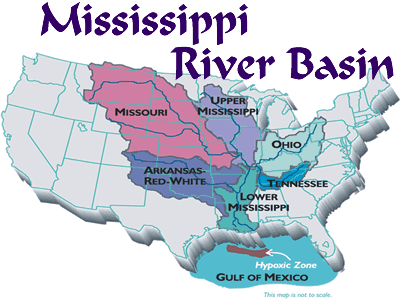
 The Mississippi River is called the Lower Mississippi River from its confluence with the Ohio River to its mouth at the Gulf of Mexico. Measured by water volume, the Lower Mississippi's primary branch is the Ohio River. At the confluence of the Ohio and the Middle Mississippi, the Ohio is the bigger river, with its long-term mean discharge at Cairo, Illinois being 281500 cuft/s, while the long-term mean discharge of the Mississippi at Thebes, Illinois (just upriver from Cairo) is 208200 cuft/s. Thus, by volume, the main branch of the Mississippi River system at Cairo can be considered to be the Ohio River (and the Allegheny River
further upstream), rather than the Middle Mississippi.
In addition to the Ohio River
, the major tributaries of the Lower Mississippi River are the White River
, flowing in at the White River National Wildlife Refuge
in east central Arkansas; the Arkansas River
, joining the Mississippi at Arkansas Post
; the Big Black River in Mississippi; the Yazoo River
, meeting the Mississippi at Vicksburg, Mississippi
; and the Red River in Louisiana. The widest point of the Mississippi River is in the Lower Mississippi portion where it exceeds 1 miles (1.6 km) in width in several places.
Due to deliberate water diversion at the Old River Control Structure
in Louisiana
, the Atchafalaya River
in Louisiana is now a major distributary
of the Mississippi River, with 30% of the Mississippi's flow routinely being sent to the Gulf of Mexico by this route, rather than continuing down the Mississippi's current channel past Baton Rouge and New Orleans on a longer route to the Gulf.
 The Mississippi River has the world's fourth largest drainage basin
("watershed" or "catchment"). The basin covers more than 1245000 sq mi (3,224,535.2 km²), including all or parts of 32 U.S. states and two Canadian
provinces. The drainage basin empties into the Gulf of Mexico
, part of the Atlantic Ocean
. The total catchment of the Mississippi River covers nearly 40% of the landmass of the continental United States.
 In the United States, the Mississippi River drains the majority of the area between crest of the Rocky Mountains
and the crest of the Appalachian Mountains
, except for various regions drained to Hudson Bay
by the Red River of the North
; to the Atlantic Ocean by the Great Lakes
and the Saint Lawrence River
; and to the Gulf of Mexico by the Rio Grande
, the Alabama
and Tombigbee
rivers, the Chattahoochee
and Appalachicola
rivers, and various smaller coastal waterways along the Gulf.
The Mississippi River empties into the Gulf of Mexico about 100 miles (160.9 km) downstream from New Orleans. Measurements of the length of the Mississippi from Lake Itasca to the Gulf of Mexico vary somewhat, but the United States Geological Survey
's number is 2340 miles (3,765.9 km). The retention time from Lake Itasca to the Gulf is typically about 90 days.
, which moves nearly 7 million cubic feet per second (200,000 m3/s) during wet seasons. On average, the Mississippi has only 9% the flow of the Amazon River.
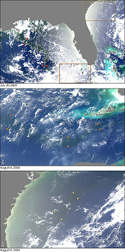
Fresh river water flowing from the Mississippi into the Gulf of Mexico does not mix into the salt water immediately. The images from NASA
's MODIS (to the right) show a large plume of fresh water, which appears as a dark ribbon against the lighter-blue surrounding waters. These images demonstrate that the plume did not mix with the surrounding sea water immediately. Instead, it stayed intact as it flowed through the Gulf of Mexico, into the Straits of Florida
, and entered the Gulf Stream
. The Mississippi River water rounded the tip of Florida and traveled up the southeast coast to the latitude of Georgia
before finally mixing in so thoroughly with the ocean that it could no longer be detected by MODIS.
Prior to 1900, the Mississippi River transported an estimated 400 million metric tons of sediment
per year from
the interior of the United States to coastal Louisiana and the Gulf of Mexico. During the last two decades, this number was only 145 million metric tons per year. The reduction in sediment transport
ed down the Mississippi River is the result of engineering modification of the Mississippi, Missouri, and Ohio rivers and their tributaries by dams, meander cutoff
s, river-training structures, and bank revetments and soil erosion
control programs in the areas drained by them.
Through a natural process known as avulsion
or delta switching, the lower Mississippi River has shifted its final course to the mouth of the Gulf of Mexico every thousand years or so. This occurs because the deposits of silt and sediment begin to clog its channel, raising the river's level and causing it to eventually find a steeper, more direct route to the Gulf of Mexico. The abandoned distributaries diminish in volume and form what are known as bayou
s. This process has, over the past 5,000 years, caused the coastline of south Louisiana to advance toward the Gulf from 15 to 50 miles (25–80 km). The currently active delta lobe is called the Birdfoot Delta, after its shape, or the Balize Delta, after La Balize, Louisiana
, the first French settlement at the mouth of the Mississippi.
of the most recent Ice Age
. The southernmost extent of this enormous glaciation extended well into the present-day United States and Mississippi basin. When the ice sheet began to recede, hundreds of feet of rich sediment were deposited, creating the flat and fertile landscape of the Mississippi Valley. During the melt, giant glacial rivers found drainage paths into the Mississippi watershed, creating such features as the Minnesota River
, James River
, and Milk River
valleys. When the ice sheet completely retreated, many of these "temporary" rivers found paths to Hudson Bay
or the Arctic Ocean
, leaving the Mississippi Basin with many features "oversized" for the existing rivers to have carved in the same time period.
Ice sheets during the Illinoian Stage about 300,000 to 132,000 years before present, blocked the Mississippi near Rock Island, Illinois, diverting it to its present channel farther to the west, the current western border of Illinois. The Hennepin Canal roughly follows the ancient channel of the Mississippi downstream from Rock Island to Hennepin, Illinois
. South of Hennepin, to Alton, Illinois
, the current Illinois River
follows the ancient channel used by the Mississippi River before the Illinoian Stage.
, leaving a small part of Tipton County, Tennessee
, attached to Arkansas
and separated from the rest of Tennessee
by the new river channel. Since this event was an avulsion
, rather than the effect of incremental erosion and deposition, the state line remains located in the old channel.
or through Lake Pontchartrain
— might become the Mississippi's main channel if flood-control structures are overtopped or heavily damaged during a severe flood. Such a course change may not be imminent; however, as the Mississippi returned to its present course following the great floods in 2011
.
Failure of the Old River Control Structure
, the Morganza Spillway
, or nearby levees would likely re-route the main channel of the Mississippi through Louisiana
's Atchafalaya Basin
and down the Atchafalaya River
to reach the Gulf of Mexico south of Morgan City
in southern Louisiana. This route provides a more direct path to the Gulf of Mexico
than the present Mississippi River channel through Baton Rouge and New Orleans. While the risk of such a diversion is present during any major flood event (such as those of 1973 or 2011), such a change has so far been prevented by active human intervention involving the construction, maintenance, and operation of various levees, spillways, and other control structures by the U.S. Army Corps of Engineers.
 The Old River Control Structure, between the present Mississippi River channel and the Atchafalaya Basin, sits at the normal water elevation and is ordinarily used to divert 30% of the Mississippi's flow to the Atchafalaya River. There is a steep drop here away from the Mississippi's main channel into the Atchafalaya Basin. If this facility were to fail during a major flood, there is a strong concern the water would scour
and erode the river bottom enough to capture the Mississippi's main channel. The structure was nearly lost during the 1973 flood, but repairs and improvements were made after engineers studied the forces at play. In particular, the Corps of Engineers made many improvements and constructed additional facilities for routing water through the vicinity. These additional facilities give the Corps much more flexibility and potential flow capacity than they had in 1973, which further reduces the risk of a catastrophic failure in this area during other major floods, such as those of 2011
.
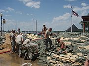
Because the Morganza Spillway is located at slightly higher elevation well back from the river, it is normally dry on both sides. Even if this structure were to fail at the crest during a severe flood, the flood waters would have to cause a significant amount of erosion, down to normal water levels, before the Mississippi could permanently jump channel at this location. During the 2011 floods, the Corps of Engineers decided to open the Morganza Spillway to 1/4 of its capacity to allow 150,000 ft3/sec of water to flood the Morganza and Atchafalaya floodways and continue directly to the Gulf of Mexico, bypassing Baton Rouge and New Oreans. In addition to reducing the Mississippi River crest downstream, this diversion is also reducing the chances of a channel change by reducing stress on the other elements of the control system.
Some geologists have noted that the possibility for course change into the Atchafalaya also exists in the area immediately north of the Old River Control Structure. Army Corps of Engineers geologist Fred Smith once stated, "The Mississippi wants to go west. 1973 was a forty-year flood. The big one lies out there somewhere—when the structures can't release all the floodwaters and the levee is going to have to give way. That is when the river's going to jump its banks and try to break through."
If the main channel of the lower Mississippi River changes permanently to the Old River and Atchafalya River channels in the Atchafalaya Basin, thus bypassing Baton Rouge and New Orleans, the ecological and economic consequences for Louisiana, the region, the nation, and international commerce would be immense.
Sedimentation
and erosion
patterns would quickly change greatly, including development of a new river channel and delta, as well as a new pattern of floodplain
s, natural levees
, and backswamp
s. Changes to salinity
of coastal waters (less saline near new delta
, more saline near the present delta) would affect marine life, fisheries, beach
es, and coastal marshes
. The abandoned river channel would eventually fill and revegetate
, probably with a major influx of invasive non-native species
. On the other hand, the low-lying outer parts of the present delta, lacking replenishment, would mostly soon erode away. Over time, the new channel would itself develop meander
s and cutoffs
, eventually leading to formation of new oxbow lake
s.
Human society would also be greatly altered locally, with broader consequences nationally and globally. Transportation by road, rail, sea, and river barge would all be dramatically affected, and various sizable new bridge
s would be urgently needed. Existing port facilities
may have to be relocated or replaced, and channel alterations would be needed to maintain any substantial degree of commercial shipping on either the new or the old channel of the Mississippi. Power lines, pipelines
, and fiber-optic and other communication
s lines would be similarly disrupted, and housing, agriculture
, forestry
, petroleum-production facilities
, and other land uses would be suddenly altered, as would patterns of recreational activities
. Morgan City
in particular would be quite heavily impacted. Values of many properties
would be greatly altered, some increasing, some decreasing, and ownership claims would need to be resolved for the newly exposed land of the old riverbed.
Another possible course change for the Mississippi River is a diversion into Lake Pontchartrain
near New Orleans, Louisiana
. This route is currently controlled by the he Bonnet Carré Spillway
, built to reduce flooding in New Orleans. However, the spillway and an imperfect natural levee about 4–6 meters (12 to 20 feet) high are all that prevents the Mississippi from taking a new, shorter course through Lake Pontchartrain to the Gulf of Mexico. Diversion of the Mississippi's main channel through Lake Pontchartrain would have generally similar consequences to an Atchafalaya diversion, but to a lesser extent, since the present river channel would remain in use past Baton Rouge and into the New Orleans area. Following a Lake Pontchartrain diversion, the Mississippi's new delta would develop offshore of southern Mississippi.
, along the Mississippi River near New Madrid, Missouri
, between Memphis and St. Louis, is related to an aulacogen
(failed rift) that formed at the same time as the Gulf of Mexico. This area is still quite active seismically. Four great earthquakes in 1811 and 1812, estimated at approximately 8 on the Richter magnitude scale
, had tremendous local effects in the then sparsely settled area, and were felt in many other places in the midwestern and eastern U.S. These earthquakes created Reelfoot Lake
in Tennessee from the altered landscape near the river, and temporarily reversed the direction of flow of the Mississippi itself.
to Louisiana
, and was used to define portions of these states' borders, with Wisconsin
, Illinois
, Kentucky
, Tennessee
, and Mississippi
along the east side of the river, and Iowa
, Missouri
, and Arkansas
along its west side. Substantial parts of both Minnesota and Louisiana are on either side of the river, although the Mississippi defines part of the boundary of each of these states.
In all of these cases, the middle of the riverbed at the time the borders were established was used as the line to define the borders between adjacent states. In various areas, the river has since shifted, but the state borders have not changed, still following the former bed of the Mississippi River as of their establishment, leaving several small isolated areas of one state across the new river channel, contiguous with the adjacent state. Also, due to a meander in the river, a small part of western Kentucky is contiguous with Tennessee, but isolated from the rest of its state.


 Many of the communities along the Mississippi River are listed below; most have either historic significance or cultural lore connecting them to the river. They are sequenced from the source of the river to its end.
 The first bridge across the Mississippi River was built in 1855. It spanned the river in Minneapolis, Minnesota
where the current Hennepin Avenue Bridge
is located. No highway or railroad tunnels cross under the Mississippi River.
The first railroad bridge across the Mississippi was built in 1856. It spanned the river between the Rock Island Arsenal
in Illinois
and Davenport, Iowa. Steamboat captains of the day, fearful of competition from the railroads, considered the new bridge "a hazard to navigation". Two weeks after the bridge opened, the steamboat Effie Afton rammed part of the bridge, catching it on fire. Legal proceedings ensued, with Abraham Lincoln
defending the railroad. The lawsuit went to the Supreme Court of the United States
and was eventually ruled in favor of the railroad.
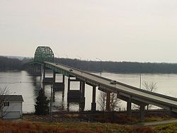
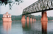
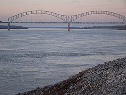
Below is a general overview of selected Mississippi bridges which have notable engineering or landmark significance, with their cities or locations. They are sequenced from the Upper Mississippi's source to the Lower Mississippi's mouth.
s and other vessels that make the main stem
Mississippi one of the great commercial waterway
s of the world. The task of maintaining a navigation channel is the responsibility of the United States Army Corps of Engineers
, which was established in 1802. Earlier projects began as early as 1829 to remove snags, close off secondary channels and excavate rocks and sandbar
s.
Steamboats entered trade in the 1820s, so the period 1830 1850 became the golden age of steamboats. As there were few roads or rails in the lands of the Louisiana Purchase, river traffic was an ideal solution. Cotton, timber and food came down the river, as did Appalachian coal. The port of New Orleans boomed as it was the trans-shipment point to deep sea ocean vessels. As a result, the image of the twin stacked, wedding cake Mississippi steamer entered into American mythology. Steamers worked the entire route from the trickles of Montana, to the Ohio river; down the Missouri and Tennessee, to the main channel of the Mississippi. Only the arrival of the railroads in the 1880s did steamboat traffic diminish. Steamboats remained a feature until the 1920s. Most have been superseded by pusher tugs. A few survive as icons—the Delta Queen
and the River Queen
for instance.
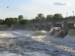
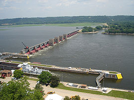
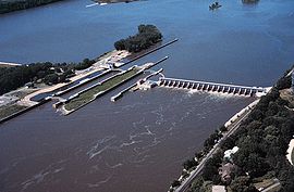
A series of 29 locks
and dams on the upper Mississippi, most of which were built in the 1930s, is designed primarily to maintain a 9 feet (2.7 m) deep channel for commercial barge traffic. The lakes formed are also used for recreational boating and fishing. The dams make the river deeper and wider but do not stop it. No flood control is intended. During periods of high flow, the gates, some of which are submersible, are completely opened and the dams simply cease to function. Below St. Louis, the Mississippi is relatively free-flowing, although it is constrained by numerous levees and directed by numerous wing dam
s.
 In 1829, there were surveys of the two major obstacles on the upper Mississippi, the Des Moines Rapids and the Rock Island Rapids, where the river was shallow and the riverbed was rock. The Des Moines Rapids were about 11 mi (18 km) long and just above the mouth of the Des Moines River
at Keokuk, Iowa. The Rock Island Rapids were between Rock Island
and Moline, Illinois
. Both rapids were considered virtually impassable.
In 1848, the Illinois and Michigan Canal
was built to connect the Mississippi River to Lake Michigan
via the Illinois River near Peru, Illinois
. The canal allowed shipping between these important waterways. In 1900, the canal was replaced by the Chicago Sanitary and Ship Canal
. The second canal, in addition to shipping, also allowed Chicago to address specific health issues (typhoid fever
, cholera
and other waterborne diseases) by sending its waste down the Illinois and Mississippi river systems rather than polluting its water source of Lake Michigan.
The Corps of Engineers recommended the excavation of a 5 ft (1.5 m) deep channel at the Des Moines Rapids
, but work did not begin until after Lieutenant Robert E. Lee
endorsed the project in 1837. The Corps later also began excavating the Rock Island Rapids. By 1866, it had become evident that excavation was impractical, and it was decided to build a canal around the Des Moines Rapids. The canal opened in 1877, but the Rock In 1878, Congress authorized the Corps to establish a 4.5 feet (1.4 m) deep channel to be obtained by building wing dams which direct the river to a narrow channel causing it to cut a deeper channel, by closing secondary channels and by dredging. The channel project was complete when the Moline Lock, which bypassed the Rock Island Rapids, opened in 1907.
To improve navigation between St. Paul, Minnesota, and Prairie du Chien, Wisconsin
, the Corps constructed several dams on lakes in the headwaters area, including Lake Winnibigoshish
and Lake Pokegama. The dams, which were built beginning in the 1880s, stored spring run-off which was released during low water to help maintain channel depth.
In 1907, Congress authorized a 6 feet (1.8 m) deep channel project on the Mississippi, which was not complete when it was abandoned in the late 1920s in favor of the 9 feet (2.7 m) deep channel project.
at Keokuk, Iowa
, the first dam below St. Anthony Falls. Built by a private power company to generate electricity, the Keokuk dam was one of the largest hydro-electric plants in the world at the time. The dam also eliminated the Des Moines Rapids. Lock and Dam No. 1
was completed in Minneapolis, Minnesota in 1917. Lock and Dam No. 2
, near Hastings, Minnesota
was completed in 1930.
 Prior to the Great Mississippi Flood of 1927
, the Corps' primary strategy was to close off as many side channels as possible to increase the flow in the main river. It was thought that the river's velocity
would scour off bottom sediment
s, deepening the river and decreasing the possibility of flooding. The 1927 flood proved this to be so wrong that communities threatened by the flood began to create their own levee breaks to relieve the force of the rising river.
The Rivers and Harbors Act of 1930 authorized the 9 feet (2.7 m) channel project, which called for a navigation channel 9 ft (2.7 m) deep and 400 ft (120 m) wide to accommodate multiple-barge tows. This was achieved by a series of locks and dams, and by dredging. Twenty-three new locks and dams were built on the upper Mississippi in the 1930s in addition to the three already in existence.
Until the 1950s, there was no dam below Lock and Dam 26 at Alton, Illinois. Chain of Rocks Lock
(Lock and Dam No. 27), which consists of a low-water dam and an 8.4 mi (13.5 km) long canal, was added in 1953, just below the confluence with the Missouri River, primarily to bypass a series of rock ledges at St. Louis. It also serves to protect the St. Louis city water intakes during times of low water.
U.S. government scientists determined in the 1950s that the Mississippi River was starting to switch to the Atchafalaya River channel because of its much steeper path to the Gulf of Mexico. Eventually the Atchafalaya River would capture the Mississippi River and become its main channel to the Gulf of Mexico, leaving New Orleans on a side channel. As a result, the U.S. Congress
authorized a project called the Old River Control Structure
, which has prevented the Mississippi River from leaving its current channel that drains into the Gulf via New Orleans.
Because the large scale of high-energy water flow threatened to damage the structure, an auxiliary flow control station was built adjacent to the standing control station. This US$ 300 million project was completed in 1986 by the U.S. Army Corps Of Engineers
. Beginning in the 1970s, the Corps applied hydrological transport model
s to analyze flood flow and water quality of the Mississippi. Dam 26 at Alton, Illinois
, which had structural problems, was replaced by the Mel Price Lock and Dam in 1990. The original Lock and Dam 26 was demolished.
 The Corps now actively creates and maintains spillways and floodways to divert periodic water surges into backwater channels and lakes, as well as route part of the Mississippi's flow into the Atchafalaya Basin
and from there to the Gulf of Mexico
, bypassing Baton Rouge and New Orleans. The main structures are the Birds Point-New Madrid Floodway
in Missouri; the Old River Control Structure
and the Morganza Spillway
in Louisiana, which direct excess water down the west and east sides (respectively) of the Atchafalaya River
; and the Bonnet Carré Spillway
, also in Louisiana, which directs floodwaters to Lake Pontchartrain
(see diagram).
Some of the pre-1927 strategy is still in use today, with the Corps actively cutting the necks of horseshoe bends
, allowing the water to move faster and reducing flood heights.

 The area of the Mississippi River basin was first settled by hunting and gathering
Native American peoples
and is considered one the few independent centers of plant domestication in human history. Evidence of early cultivation of sunflower
, a goosefoot, a marsh elder and an indigenous squash dates to the 4th millennium BCE. The lifestyle gradually became more settled after around 1000 BCE during what is now called the Woodland period
, with increasing evidence of shelter construction, pottery, weaving
and other practices. A network of trade routes referred to as the Hopewell interaction sphere was active along the waterways between about 200 and 500 CE, spreading common cultural practices over the entire area between the Gulf of Mexico and the Great Lakes. A period of more isolated communities followed, and agriculture introduced from Mesoamerica
based on the Three Sisters
(maize
, beans and squash) gradually came to dominate. After around 800 CE there arose an advanced agricultural society today referred to as the Mississippian culture
, with evidence of highly stratified complex chiefdom
s and large population centers. The most prominent of these, now called Cahokia
, was occupied between about 600 and 1400 CE and at its peak numbered between 8,000 and 40,000 inhabitants, larger than London
, England
of that time. At the time of first contact with Europeans, Cahokia and many other Mississippian cities had dispersed, and archaeological
finds attest to increased social stress.
Modern American Indian nations inhabiting the Mississippi basin include Cheyenne
, Sioux
, Ojibwe, Potawatomi
, Ho-Chunk
, Fox, Kickapoo, Tamaroa
, Moingwena, Quapaw
and Chickasaw
.
The word Mississippi itself comes from Messipi, the French rendering of the Anishinaabe
(Ojibwe or Algonquin) name for the river, Misi-ziibi (Great River). The Ojibwe called Lake Itasca Omashkoozo-zaaga'igan (Elk Lake) and the river flowing out of it Omashkoozo-ziibi (Elk River). After flowing into Lake Bemidji
, the Ojibwe called the river Bemijigamaag-ziibi (River from the Traversing Lake). After flowing into Cass Lake
, the name of the river changes to Gaa-miskwaawaakokaag-ziibi (Red Cedar River) and then out of Lake Winnibigoshish
as Wiinibiigoozhish-ziibi (Miserable Wretched Dirty Water River), Gichi-ziibi (Big River) after the confluence with the Leech Lake River
, then finally as Misi-ziibi (Great River) after the confluence with the Crow Wing River
. After the expeditions by Giacomo Beltrami
and Henry Schoolcraft
, the longest stream above the juncture of the Crow Wing River and Gichi-ziibi was named "Mississippi River". The Mississippi River Band of Chippewa Indians
, known as the Gichi-ziibiwininiwag, are named after the stretch of the Mississippi River known as the Gichi-ziibi. The Cheyenne
, one of the earliest inhabitants of the upper Mississippi River, called it the Máʼxe-éʼometaaʼe (Big Greasy River) in the Cheyenne language
.
 On May 8, 1541, Spanish explorer Hernando de Soto became the first recorded European to reach the Mississippi River, which he called Río del Espíritu Santo ("River of the Holy Spirit"), in the area of what is now Mississippi. In Spanish, the river is called Río Mississippi.
French explorers Louis Jolliet
and Jacques Marquette
, began exploring the Mississippi in the 17th century. Marquette traveled with a Sioux
who named it Ne Tongo ("Big river" in Sioux language
) in 1673. Marquette proposed calling it the River of the Immaculate Conception
.
When Louis Jolliet
explored the Mississippi Valley in the 17th century, natives guided him to a quicker way to return to French Canada via the Illinois River. When he found the Chicago Portage
, he remarked that a canal of "only half a league
" (less than 2 miles (3.2 km), 3 km) would join the Mississippi and the Great Lakes. In 1848, the continental divide
separating the waters of the Great Lakes and the Mississippi Valley was breached by the Illinois and Michigan canal
via the Chicago River
. This both accelerated the development, and forever changed the ecology of the Mississippi Valley and the Great Lakes.
In 1682, René-Robert Cavelier, Sieur de La Salle
and Henri de Tonti
claimed the entire Mississippi River Valley for France, calling the river Colbert River after Jean-Baptiste Colbert
and the region La Louisiane
, for King Louis XIV
. On March 2, 1699, Pierre Le Moyne d'Iberville
rediscovered the mouth of the Mississippi, following the death of La Salle. The French built the small fort of La Balise
there to control passage.
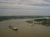
In 1718, about 100 miles (160.9 km) upriver, New Orleans was established along the river crescent by Jean-Baptiste Le Moyne, Sieur de Bienville
, with construction patterned after the 1711 resettlement on Mobile Bay of Mobile
, the capital of French Louisiana at the time.
the Mississippi became the border between the British and Spanish Empires. The Treaty of Paris (1763)
gave Great Britain
rights to all land east of the Mississippi and Spain rights to land west of the Mississippi. Spain also ceded Florida
to Britain to regain Cuba
, which the British occupied during the war. Britain then divided the territory into East
and West Florida
.
Article 8 of the Treaty of Paris (1783)
states, "The navigation of the river Mississippi, from its source to the ocean, shall forever remain free and open to the subjects of Great Britain and the citizens of the United States". With this treaty, which ended the American Revolutionary War
, Britain also ceded West Florida back to Spain to regain the Bahamas
, which Spain had occupied during the war. In 1800, under duress from Napoleon of France, Spain ceded an undefined portion of West Florida to France. When France then sold the Louisiana Territory to the US in 1803, a dispute arose again between Spain and the U.S. on which parts of West Florida exactly had Spain ceded to France, which would in turn decide which parts of West Florida were now U.S. property versus Spanish property. These aspirations ended when Spain was pressured into signing Pinckney's Treaty
in 1795.
France reacquired 'Louisiana' from Spain in the secret Treaty of San Ildefonso
in 1800. The United States then bought the territory from France in the Louisiana Purchase
of 1803. In 1815, the U.S. defeated Britain at the Battle of New Orleans
, part of the War of 1812
, securing American control of the river. So many settlers traveled westward through the Mississippi river basin, as well as settled in it, that Zadok Cramer wrote a guide book called The Navigator
, detailing the features and dangers and navigable waterways of the area. It was so popular that he updated and expanded it through 12 editions over a period of 25 years.
 The colonization of the area was barely slowed by the three earthquakes in 1811 and 1812, estimated at approximately 8 on the Richter magnitude scale
, that were centered near New Madrid, Missouri
.
, covered the steamboat
commerce which took place from 1830 to 1870 on the river before more modern ships replaced the steamer. The book was published first in serial form in Harper's Weekly
in seven parts in 1875. The full version, including a passage from the unfinished Adventures of Huckleberry Finn
and works from other authors, was published by James R. Osgood & Company in 1885.
The first steamboat to travel the full length of the Lower Mississippi from the Ohio River to New Orleans was the New Orleans in December 1811. Its maiden voyage occurred during the series of New Madrid earthquakes in 1811–12. Steamboat transport remained a viable industry, both in terms of passengers and freight until the end of the first decade of the 20th century. Among the several Mississippi River system steamboat companies was the noted Anchor Line, which, from 1859 to 1898, operated a luxurious fleet of steamers between St. Louis and New Orleans.
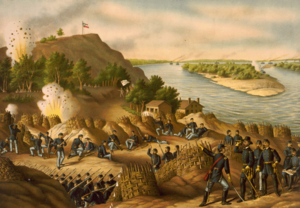 Control of the river was a strategic objective of both sides in the American Civil War
. In 1862 Union's
forces coming down the river successfully cleared Confederate defenses at Island Number 10
and Memphis, Tennessee
, while Naval forces coming upriver from the Gulf of Mexico captured New Orleans, Louisiana
. The remaining major Confederate stronghold was on the heights overlooking the river at Vicksburg, Mississippi
, and the Union's Vicksburg Campaign
(December 1862 to July, 1863), and the fall of Port Hudson, completed control of the lower Mississippi River. The Union victory ending the Siege of Vicksburg on July 4, 1863 was pivotal to the Union's final victory of the Civil War.
In the spring of 1927, the river broke out of its banks in 145 places, during the Great Mississippi Flood of 1927
and inundated 27000 sq mi (69,929.7 km²) to a depth of up to 30 ft (9.1 m).
On October 20, 1976, the automobile ferry, MV George Prince
, was struck by a ship traveling upstream as the ferry attempted to cross from Destrehan, Louisiana
, to Luling, Louisiana
. Seventy-eight passengers and crew died; only eighteen survived the accident.
In 1988, record low water levels provided an opportunity and obligation to examine the climax of the wooden-hulled age. The Mississippi fell to 10 feet (3 m) below zero on the Memphis gauge. Water craft remains were exposed in an area of 4.5 acres (18,210.9 m²) on the bottom of the Mississippi River at West Memphis, Arkansas. They dated to the late 19th to early 20th centuries. The State of Arkansas, the Arkansas Archeological Survey, and the Arkansas Archeological Society responded with a two-month data recovery effort. The fieldwork received national media attention as good news in the middle of a drought.
The Great Flood of 1993 was another significant flood, primarily affecting the Mississippi above its confluence with the Ohio River at Cairo, Illinois.
Two portions of the Mississippi were designated as American Heritage Rivers
in 1997: the lower portion around Louisiana and Tennessee, and the upper portion around Iowa, Illinois, Minnesota and Missouri.
 In 2002, Slovenia
n long-distance swimmer Martin Strel
swam the entire length of the river, from Minnesota to Louisiana, over the course of 68 days.
In 2005, the Source to Sea Expedition paddled the Mississippi and Atchafalaya River
s to benefit the Audubon Society's Upper Mississippi River Campaign.
On August 1, 2007, the I-35W Mississippi River bridge in Minneapolis collapsed during the evening rush hour.
Extensive flooding in April, May, and June 2011
was compared to the Great Mississippi Flood of 1927
and the Great Mississippi and Missouri Rivers Flood of 1993.
. Ralph Samuelson
of Lake City, Minnesota
, created and refined his skiing technique in late June and early July 1922. He later performed the first water ski jump in 1925 and was pulled along at 80 mph (35.8 m/s) by a Curtiss flying boat
later that year.
There are seven National Park Service
sites along the Mississippi River. The Mississippi National River and Recreation Area
is the National Park Service site dedicated to protecting and interpreting the Mississippi River itself. The other six National Park Service sites along the river are (listed from north to south):
North America
North America is a continent wholly within the Northern Hemisphere and almost wholly within the Western Hemisphere. It is also considered a northern subcontinent of the Americas...
. Flowing entirely in the United States
United States
The United States of America is a federal constitutional republic comprising fifty states and a federal district...
, this river rises in western Minnesota
Minnesota
Minnesota is a U.S. state located in the Midwestern United States. The twelfth largest state of the U.S., it is the twenty-first most populous, with 5.3 million residents. Minnesota was carved out of the eastern half of the Minnesota Territory and admitted to the Union as the thirty-second state...
and meander
Meander
A meander in general is a bend in a sinuous watercourse. A meander is formed when the moving water in a stream erodes the outer banks and widens its valley. A stream of any volume may assume a meandering course, alternately eroding sediments from the outside of a bend and depositing them on the...
s slowly southwards for 2530 miles (4,071.6 km) to the Mississippi River Delta
Mississippi River Delta
The Mississippi River Delta is the modern area of land built up by alluvium deposited by the Mississippi River as it slows down and enters the Gulf of Mexico...
at the Gulf of Mexico
Gulf of Mexico
The Gulf of Mexico is a partially landlocked ocean basin largely surrounded by the North American continent and the island of Cuba. It is bounded on the northeast, north and northwest by the Gulf Coast of the United States, on the southwest and south by Mexico, and on the southeast by Cuba. In...
. With its many tributaries
Tributary
A tributary or affluent is a stream or river that flows into a main stem river or a lake. A tributary does not flow directly into a sea or ocean...
, the Mississippi's watershed
Drainage basin
A drainage basin is an extent or an area of land where surface water from rain and melting snow or ice converges to a single point, usually the exit of the basin, where the waters join another waterbody, such as a river, lake, reservoir, estuary, wetland, sea, or ocean...
drains all or parts of 31 U.S. state
U.S. state
A U.S. state is any one of the 50 federated states of the United States of America that share sovereignty with the federal government. Because of this shared sovereignty, an American is a citizen both of the federal entity and of his or her state of domicile. Four states use the official title of...
s between the Rocky
Rocky Mountains
The Rocky Mountains are a major mountain range in western North America. The Rocky Mountains stretch more than from the northernmost part of British Columbia, in western Canada, to New Mexico, in the southwestern United States...
and Appalachian Mountains
Appalachian Mountains
The Appalachian Mountains #Whether the stressed vowel is or ,#Whether the "ch" is pronounced as a fricative or an affricate , and#Whether the final vowel is the monophthong or the diphthong .), often called the Appalachians, are a system of mountains in eastern North America. The Appalachians...
and even reaches into southern Canada
Canada
Canada is a North American country consisting of ten provinces and three territories. Located in the northern part of the continent, it extends from the Atlantic Ocean in the east to the Pacific Ocean in the west, and northward into the Arctic Ocean...
. The Mississippi ranks fourth longest and tenth largest among the world's rivers.
Native American
Indigenous peoples of the Americas
The indigenous peoples of the Americas are the pre-Columbian inhabitants of North and South America, their descendants and other ethnic groups who are identified with those peoples. Indigenous peoples are known in Canada as Aboriginal peoples, and in the United States as Native Americans...
s lived along the Mississippi and its tributaries. Most were hunter-gatherer
Hunter-gatherer
A hunter-gatherer or forage society is one in which most or all food is obtained from wild plants and animals, in contrast to agricultural societies which rely mainly on domesticated species. Hunting and gathering was the ancestral subsistence mode of Homo, and all modern humans were...
s or herders, but some such as the Mound builders formed prolific agricultural societies. The arrival of Europe
Europe
Europe is, by convention, one of the world's seven continents. Comprising the westernmost peninsula of Eurasia, Europe is generally 'divided' from Asia to its east by the watershed divides of the Ural and Caucasus Mountains, the Ural River, the Caspian and Black Seas, and the waterways connecting...
ans in the 1500s forever changed the native way of life as first explorers, then settlers, ventured into the basin in increasing numbers. The river served first as barrier – forming borders for New Spain
New Spain
New Spain, formally called the Viceroyalty of New Spain , was a viceroyalty of the Spanish colonial empire, comprising primarily territories in what was known then as 'América Septentrional' or North America. Its capital was Mexico City, formerly Tenochtitlan, capital of the Aztec Empire...
, New France
New France
New France was the area colonized by France in North America during a period beginning with the exploration of the Saint Lawrence River by Jacques Cartier in 1534 and ending with the cession of New France to Spain and Great Britain in 1763...
, and the early United States – then as vital transportation artery and communications link. In the 19th century, during the height of Manifest Destiny
Manifest Destiny
Manifest Destiny was the 19th century American belief that the United States was destined to expand across the continent. It was used by Democrat-Republicans in the 1840s to justify the war with Mexico; the concept was denounced by Whigs, and fell into disuse after the mid-19th century.Advocates of...
, the Mississippi and several western tributaries, most notably the Missouri
Missouri River
The Missouri River flows through the central United States, and is a tributary of the Mississippi River. It is the longest river in North America and drains the third largest area, though only the thirteenth largest by discharge. The Missouri's watershed encompasses most of the American Great...
, formed pathways for pioneers partaking in the western expansion of the United States.
Formed from thick layers of this river's silt deposits, the Mississippi River Valley is one of the most fertile agricultural
Agriculture
Agriculture is the cultivation of animals, plants, fungi and other life forms for food, fiber, and other products used to sustain life. Agriculture was the key implement in the rise of sedentary human civilization, whereby farming of domesticated species created food surpluses that nurtured the...
regions of the country and as a result came the rise of the river's storied steamboat
Steamboat
A steamboat or steamship, sometimes called a steamer, is a ship in which the primary method of propulsion is steam power, typically driving propellers or paddlewheels...
era. During the American Civil War
American Civil War
The American Civil War was a civil war fought in the United States of America. In response to the election of Abraham Lincoln as President of the United States, 11 southern slave states declared their secession from the United States and formed the Confederate States of America ; the other 25...
, the Mississippi's capture by Union forces marked a turning point towards victory because of this very importance as a route of trade and travel, not least to the Confederacy
Confederate States of America
The Confederate States of America was a government set up from 1861 to 1865 by 11 Southern slave states of the United States of America that had declared their secession from the U.S...
. Because of substantial growth of cities, and the larger ships and barge
Barge
A barge is a flat-bottomed boat, built mainly for river and canal transport of heavy goods. Some barges are not self-propelled and need to be towed by tugboats or pushed by towboats...
s that have supplanted riverboats, the decades following the 1900s saw massive engineering works
River engineering
River engineering is the process of planned human intervention in the course, characteristics or flow of a river with the intention of producing some defined benefit. People have intervened in the natural course and behaviour of rivers since before recorded history - to manage the water resources,...
applied to the river system, such as the often in-combination construction of levee
Levee
A levee, levée, dike , embankment, floodbank or stopbank is an elongated naturally occurring ridge or artificially constructed fill or wall, which regulates water levels...
s, lock
Lock (water transport)
A lock is a device for raising and lowering boats between stretches of water of different levels on river and canal waterways. The distinguishing feature of a lock is a fixed chamber in which the water level can be varied; whereas in a caisson lock, a boat lift, or on a canal inclined plane, it is...
s and dam
Dam
A dam is a barrier that impounds water or underground streams. Dams generally serve the primary purpose of retaining water, while other structures such as floodgates or levees are used to manage or prevent water flow into specific land regions. Hydropower and pumped-storage hydroelectricity are...
s.
Since modern development of the basin began, the Mississippi has also seen its share of pollution and environmental problems – most notably large volumes of agricultural runoff, which has led to the Gulf of Mexico dead zone off the Delta. In recent years, the river has shown a steady shift towards the Atchafalaya River
Atchafalaya River
The Atchafalaya River is a distributary of the Mississippi River and Red River in south central Louisiana in the United States. It flows south, just west of the Mississippi River....
channel in the Delta; a course change would prove disastrous to seaports such as New Orleans
New Orleans, Louisiana
New Orleans is a major United States port and the largest city and metropolitan area in the state of Louisiana. The New Orleans metropolitan area has a population of 1,235,650 as of 2009, the 46th largest in the USA. The New Orleans – Metairie – Bogalusa combined statistical area has a population...
. A system of dikes and gates has so far held the Mississippi at bay, but due to fluvial
Fluvial
Fluvial is used in geography and Earth science to refer to the processes associated with rivers and streams and the deposits and landforms created by them...
processes the shift becomes more likely each year.
Name
In addition to historical traditions shown by names, there are at least two other measures of a river'sRiver
A river is a natural watercourse, usually freshwater, flowing towards an ocean, a lake, a sea, or another river. In a few cases, a river simply flows into the ground or dries up completely before reaching another body of water. Small rivers may also be called by several other names, including...
identity, one being the largest branch (by water volume), and the other being the longest branch. Using the largest-branch criterion, the Ohio would be the main branch of the Lower Mississippi, not the Middle and Upper Mississippi. Using the longest-branch criterion, the Middle Mississippi-Missouri-Jefferson-Beaverhead-Red Rock-Hellroaring Creek River would be the main branch. In either of these cases, the Upper Mississippi from St. Louis, Missouri, to Minnesota, despite its name, would not be part of the more significant branch.
While the Missouri River, flowing from the confluence of the Jefferson
Jefferson River
The Jefferson River is a tributary of the Missouri River, approximately long, in the U.S. state of Montana. The Jefferson River and the Madison River form the official beginning of the Missouri at Missouri Headwaters State Park near Three Forks...
, Madison
Madison River
The Madison River is a headwater tributary of the Missouri River, approximately 183 miles long, in Wyoming and Montana. Its confluence with the Jefferson and Gallatin rivers near Three Forks, Montana form the Missouri River....
and Gallatin River
Gallatin River
The Gallatin River is a tributary of the Missouri River, approximately 120 mi , in the U.S. states of Wyoming and Montana...
s to the Mississippi, is the longest continuously named river in the United States, the serial combination of Hellroaring Creek and the Red Rock, Beaverhead, Jefferson, Missouri, Middle Mississippi, and Lower Mississippi rivers, considered as one continuous waterway, is the longest river in North America and the third or fourth longest river in the world. Its length of at least 3745 mi (6,027 km) is exceeded only by the Nile, the Amazon, and perhaps the Yangtze River
Yangtze River
The Yangtze, Yangzi or Cháng Jiāng is the longest river in Asia, and the third-longest in the world. It flows for from the glaciers on the Tibetan Plateau in Qinghai eastward across southwest, central and eastern China before emptying into the East China Sea at Shanghai. It is also one of the...
among the longest rivers in the world. The source of this waterway is at Brower's Spring
Brower's Spring
Brower's Spring is a spring in the Centennial Mountains of Montana that is believed to be the ultimate headwaters of the Missouri River.The spring is named for Jacob V. Brower who in 1896 declared it to be the source of the Missouri in The Missouri: Its Utmost Source...
, 8800 feet (2,682.2 m) above sea level in southwestern Montana
Montana
Montana is a state in the Western United States. The western third of Montana contains numerous mountain ranges. Smaller, "island ranges" are found in the central third of the state, for a total of 77 named ranges of the Rocky Mountains. This geographical fact is reflected in the state's name,...
, along the Continental Divide
Continental Divide
The Continental Divide of the Americas, or merely the Continental Gulf of Division or Great Divide, is the name given to the principal, and largely mountainous, hydrological divide of the Americas that separates the watersheds that drain into the Pacific Ocean from those river systems that drain...
outside Yellowstone National Park
Yellowstone National Park
Yellowstone National Park, established by the U.S. Congress and signed into law by President Ulysses S. Grant on March 1, 1872, is a national park located primarily in the U.S. state of Wyoming, although it also extends into Montana and Idaho...
.
The unifying name "Great American River" has been suggested for this multiple named waterway.
However, the names "Mississippi River" for the water course from Minnesota to the Gulf of Mexico, "Missouri River" for its major western tributary, and "Ohio River" for its major eastern tributary are so well established that neither reassignment of names nor creation of novel names can be seriously considered as replacements for current usage. Furthermore, the north-south course of the waterway commonly known as the Mississippi River is widely considered a convenient if approximate dividing line between the Eastern, Southern, and Midwestern United States and the Western U.S., as exemplified by the Gateway Arch
Gateway Arch
The Gateway Arch, or Gateway to the West, is an arch that is the centerpiece of the Jefferson National Expansion Memorial in St. Louis, Missouri. It was built as a monument to the westward expansion of the United States...
in St. Louis and the phrase "Trans-Mississippi", used for example in the name of the 1898 Trans-Mississippi Exposition
Trans-Mississippi Exposition
The Trans-Mississippi and International Exposition was a world's fair held in Omaha, Nebraska from June 1 to November 1 of 1898. Its goal was to showcase the development of the entire West, stretching from the Mississippi River to the Pacific Coast. The Indian Congress was held concurrently...
held in Omaha, Nebraska
Omaha, Nebraska
Omaha is the largest city in the state of Nebraska, United States, and is the county seat of Douglas County. It is located in the Midwestern United States on the Missouri River, about 20 miles north of the mouth of the Platte River...
.
Physical geography
The geographical setting of the Mississippi River includes considerations of the course of the river itself, its watershed, its outflow, its prehistoric and historic course changes, and possibilities of future course changes. The New Madrid Seismic ZoneNew Madrid Seismic Zone
The New Madrid Seismic Zone , sometimes called the New Madrid Fault Line, is a major seismic zone and a prolific source of intraplate earthquakes in the southern and midwestern United States, stretching to the southwest from New Madrid, Missouri.The New Madrid fault system was responsible for the...
along the river is also noteworthy. These various basic geographical aspects of the river in turn underlie its human history and present uses of the waterway and its adjacent lands.
River course
The Mississippi River is divided into the Upper MississippiUpper Mississippi River
The Upper Mississippi River is the portion of the Mississippi River upstream of Cairo, Illinois, United States. From the headwaters at Lake Itasca, Minnesota, the river flows approximately 2000 kilometers to Cairo, where it is joined by the Ohio River to form the Lower Mississippi...
, the Middle Mississippi, and the Lower Mississippi
Lower Mississippi River
The Lower Mississippi River is the portion of the Mississippi River downstream of Cairo, Illinois. From the confluence of the Ohio River and Upper Mississippi River at Cairo, the Lower flows just under 1600 kilometers to the Gulf of Mexico...
, with the Upper Mississippi upriver of its confluence with the Missouri River, the Middle Mississippi from there downriver to the Ohio River, and the Lower Mississippi from there downriver to the Gulf of Mexico.
The Mississippi River is known as the Upper Mississippi from its headwaters to its confluence with the Missouri River at St. Louis, Missouri. The Upper Mississippi is divided into two sections:
- The headwaters, 493 miles (793.4 km), from the source to Saint Anthony FallsSaint Anthony FallsSaint Anthony Falls, or the Falls of Saint Anthony, located northeast of downtown Minneapolis, Minnesota, was the only natural major waterfall on the Upper Mississippi River. The natural falls was replaced by a concrete overflow spillway after it partially collapsed in 1869...
in Minneapolis, MinnesotaMinneapolis, MinnesotaMinneapolis , nicknamed "City of Lakes" and the "Mill City," is the county seat of Hennepin County, the largest city in the U.S. state of Minnesota, and the 48th largest in the United States... - A navigable channel, formed by a series of man-made lakes between Minneapolis and St. Louis, Missouri, 664 miles (1,068.6 km)
The source of the Upper Mississippi branch is traditionally accepted as Lake Itasca
Lake Itasca
Lake Itasca is a small glacial lake, approximately in area, in the Headwaters area of north central Minnesota. The lake is located in southeastern Clearwater County within Itasca State Park and it has an average depth of 20–35 feet , and is 1,475 ft above sea level.The Ojibwe name for...
, 1475 feet (449.6 m) above sea level in Itasca State Park
Itasca State Park
Itasca State Park is a state park of Minnesota, United States, and contains the headwaters of the Mississippi River. The park spans of northern Minnesota, and is located about north of Park Rapids, Minnesota and from Bagley, Minnesota...
in Clearwater County, Minnesota
Clearwater County, Minnesota
As of the census of 2000, there were 8,423 people, 3,330 households, and 2,287 families residing in the county. The population density was 8 people per square mile . There were 4,114 housing units at an average density of 4 per square mile...
. The name "Itasca" is a combination of the last four letters of the Latin word for truth (veritas) and the first two letters of the Latin word for head (caput). However, the lake is in turn fed by a number of smaller streams, of which one might be selected as the river's ultimate source.
Upper Mississippi
From its origin at Lake ItascaLake Itasca
Lake Itasca is a small glacial lake, approximately in area, in the Headwaters area of north central Minnesota. The lake is located in southeastern Clearwater County within Itasca State Park and it has an average depth of 20–35 feet , and is 1,475 ft above sea level.The Ojibwe name for...
to St. Louis, Missouri
St. Louis, Missouri
St. Louis is an independent city on the eastern border of Missouri, United States. With a population of 319,294, it was the 58th-largest U.S. city at the 2010 U.S. Census. The Greater St...
, the waterway's flow is moderated by 43 dams. Fourteen of these dams are located above Minneapolis in the headwaters region and serve multiple purposes, including power generation and recreation. The remaining 29 dams, beginning in downtown Minneapolis, all contain locks and were constructed to improve commercial navigation of the upper river. Taken as a whole these 43 dams significantly shape the geography and influence the ecology of the upper river. Beginning just below Saint Paul, Minnesota
Saint Paul, Minnesota
Saint Paul is the capital and second-most populous city of the U.S. state of Minnesota. The city lies mostly on the east bank of the Mississippi River in the area surrounding its point of confluence with the Minnesota River, and adjoins Minneapolis, the state's largest city...
, and continuing throughout the upper and lower river, the Mississippi is further controlled by thousands of wing dikes that moderate the river's flow in order to maintain an open navigation channel and prevent the river from eroding its banks.
The head of navigation on the Mississippi is the Coon Rapids Dam in Coon Rapids, Minnesota
Coon Rapids, Minnesota
As of the census of 2000, there were 61,627 people, 22,578 households, and 16,572 families residing in the city. The population density was 2,718.1 people per square mile . There were 22,828 housing units at an average density of 1,007.2 per square mile...
. Before its construction in 1913, steamboats could occasionally go upstream as far as Saint Cloud, Minnesota, depending on river conditions.
The uppermost lock and dam on the Upper Mississippi River is the Upper St. Anthony Falls Lock and Dam in Minneapolis. Above the dam, the river's elevation is 799 feet (243.5 m). Below the dam, the river's elevation is 750 feet (228.6 m). This 49 feet (14.9 m) drop is the largest of all the Mississippi River locks and dams. The origin of the dramatic drop is a waterfall preserved adjacent to the lock under an apron of concrete. Saint Anthony Falls
Saint Anthony Falls
Saint Anthony Falls, or the Falls of Saint Anthony, located northeast of downtown Minneapolis, Minnesota, was the only natural major waterfall on the Upper Mississippi River. The natural falls was replaced by a concrete overflow spillway after it partially collapsed in 1869...
is the only true waterfall on the entire Mississippi River. The water elevation continues to drop steeply as it passes through the gorge carved by the waterfall.
The Upper Mississippi features various natural and artificial lakes, with its widest point being Lake Winnibigoshish
Lake Winnibigoshish
Lake Winnibigoshish is a body of water in north central Minnesota, in the Chippewa National Forest. Its name comes from the Ojibwe language Wiinibiigoozhish...
, near Grand Rapids, Minnesota
Grand Rapids, Minnesota
As of the census of 2000, there were 7,764 people, 3,446 households, and 1,943 families residing in the city. The population density was 1,057.8 people per square mile . There were 3,621 housing units at an average density of 493.3 per square mile...
, over 7 miles (11.3 km) across. Also of note is Lake Onalaska
Lake Onalaska
Lake Onalaska is a reservoir located on the Mississippi River between Wisconsin, and Minnesota. It is approximately across, and is the widest point on the Mississippi River. Located in La Crosse County in the state of Wisconsin, its latitude and longitude are . The lake is and is shored by the...
(created by Lock and Dam No. 7
Lock and Dam No. 7
Lock and Dam No. 7 is a lock and dam located near Onalaska, Wisconsin on the Upper Mississippi River. It forms pool 7 and Lake Onalaska.The facility is located on Mississippi River mile 702.5 near La Crescent, Minnesota...
), near La Crosse, Wisconsin
La Crosse, Wisconsin
La Crosse is a city in and the county seat of La Crosse County, Wisconsin, United States. The city lies alongside the Mississippi River.The 2011 Census Bureau estimates the city had a population of 52,485...
, over 4 miles (6.4 km) wide. On the other hand, Lake Pepin
Lake Pepin
Lake Pepin is a naturally occurring lake, and the widest naturally occurring part of the Mississippi River, located approximately 60 miles downstream from Saint Paul, Minnesota. It is a widening of the river on the border between Minnesota and Wisconsin. The formation of the lake was caused by the...
is natural, formed due to the delta formed by the Chippewa River of Wisconsin as it enters the Upper Mississippi; it is more than 2 miles (3.2 km) wide.
By the time the Upper Mississippi reaches Saint Paul
Saint Paul, Minnesota
Saint Paul is the capital and second-most populous city of the U.S. state of Minnesota. The city lies mostly on the east bank of the Mississippi River in the area surrounding its point of confluence with the Minnesota River, and adjoins Minneapolis, the state's largest city...
, Minnesota, below Lock and Dam #1, it has dropped more than half its original elevation and is 687 feet (209.4 m) above sea level. From St. Paul to St. Louis, Missouri, the river elevation falls much more slowly, and is controlled and managed as a series of pools created by 26 locks and dams.
The Upper Mississippi River is joined by the Minnesota River
Minnesota River
The Minnesota River is a tributary of the Mississippi River, approximately 332 miles long, in the U.S. state of Minnesota. It drains a watershed of nearly , in Minnesota and about in South Dakota and Iowa....
at Fort Snelling in the Twin Cities; the St. Croix River
St. Croix River (Wisconsin-Minnesota)
The St. Croix River is a tributary of the Mississippi River, approximately long, in the U.S. states of Wisconsin and Minnesota. The lower of the river form the border between Wisconsin and Minnesota. The river is a National Scenic Riverway under the protection of the National Park Service. A...
near Prescott, Wisconsin
Prescott, Wisconsin
Prescott is a city in Pierce County, Wisconsin at the confluence of the St. Croix River and Mississippi River. The population was 4,258 at the 2010 census, making it the second-largest city in the county after River Falls, and the largest entirely within Pierce County.Prescott was home to the...
; the Cannon River near Red Wing, Minnesota
Red Wing, Minnesota
Red Wing is a city in Goodhue County, Minnesota, United States, on the Mississippi River. The population was 16,459 at the 2010 census. It is the county seat of Goodhue County....
; the Black River (Mississippi River), La Crosse River
La Crosse River
The La Crosse River is a tributary of the Mississippi River, approximately 50 mi long, in southwestern Wisconsin in the United States.-Course:...
, and Root River (Minnesota)
Root River (Minnesota)
The Root River flows for through the Driftless Area of southeastern Minnesota and is a tributary of the Upper Mississippi River. It is an excellent river for canoeing...
in La Crosse, Wisconsin
La Crosse, Wisconsin
La Crosse is a city in and the county seat of La Crosse County, Wisconsin, United States. The city lies alongside the Mississippi River.The 2011 Census Bureau estimates the city had a population of 52,485...
; the Wisconsin River
Wisconsin River
-External links:* * * , Wisconsin Historical Society* * * *...
in Prairie du Chien, Wisconsin
Prairie du Chien, Wisconsin
Prairie du Chien is a city in and the county seat of Crawford County, Wisconsin, United States. The population was 5,911 at the 2010 census. Its Zip Code is 53821....
; the Rock River in the Quad Cities
Quad Cities
The Quad Cities is a group of five cities straddling the Mississippi River on the Iowa–Illinois boundary. These cities, Davenport and Bettendorf and Rock Island, Moline, and East Moline , are the center of the Quad Cities Metropolitan Area, which, as of 2010, had an estimated population of...
; the Iowa River
Iowa River
The Iowa River is a tributary of the Mississippi River in the state of Iowa in the United States. It is about long and is open to small river craft to Iowa City, about from its mouth...
near Wapello, Iowa
Wapello, Iowa
Wapello is a city in Louisa County, Iowa, United States. The population was 2,124 at the 2000 census. It is the county seat of Louisa County. It is pronounced whop-UH-low, and almost rhymes with Tupelo....
; the Skunk River
Skunk River
The Skunk River is a tributary of the Mississippi River in the state of Iowa in the United States.It rises in two branches, the South Skunk and the North Skunk . The headwaters of the South Skunk are in Hamilton County in north central Iowa. It flows roughly due southward, to the west of...
south of Burlington, Iowa
Burlington, Iowa
Burlington is a city in, and the county seat of Des Moines County, Iowa, United States. The population was 25,663 in the 2010 census, a decline from the 26,839 population in the 2000 census. Burlington is the center of a micropolitan area including West Burlington, Iowa and Middletown, Iowa and...
; and the Des Moines River
Des Moines River
The Des Moines River is a tributary river of the Mississippi River, approximately long to its farther headwaters, in the upper Midwestern United States...
in Keokuk, Iowa. Other major tributaries of the Upper Mississippi include the Crow River
Crow River (Minnesota)
The Crow River is a tributary of the Mississippi River in south-central Minnesota in the United States. It drains a watershed of 2,756 square miles .-Hydrography:The Crow River flows for most of its length as three streams:...
in Minnesota, the Chippewa River
Chippewa River (Wisconsin)
The Chippewa River in Wisconsin flows approximately 183 miles through west-central and northwestern Wisconsin. It was once navigable for approximately 50 miles of its length, from the Mississippi River, by Durand, northeast to Eau Claire. Its catchment defines a portion of the northern boundary...
in Wisconsin, the Maquoketa River
Maquoketa River
The Maquoketa River is a tributary of the Mississippi River, approximately long, in northeastern Iowa in the United States. Its watershed covers within a rural region of rolling hills and farmland southwest of Dubuque. It is not to be confused with the Little Maquoketa River, another distinct...
and the Wapsipinicon River
Wapsipinicon River
The Wapsipinicon River is a tributary of the Mississippi River, approximately long, in northeastern Iowa in the United States. It drains a rural farming region of rolling hills and bluffs north of Waterloo and Cedar Rapids. The initial vowel rhymes with "pop".It rises in Mower County, Minnesota...
in Iowa, and the Big Muddy River
Big Muddy River
The Big Muddy River is a river in southern Illinois. It joins the Mississippi River south of Murphysboro. The Big Muddy has been dammed near Benton, forming Rend Lake.The Big Muddy has a mud bottom for most of its length.-Hydrography:...
, Illinois River
Illinois River
The Illinois River is a principal tributary of the Mississippi River, approximately long, in the State of Illinois. The river drains a large section of central Illinois, with a drainage basin of . This river was important among Native Americans and early French traders as the principal water route...
.
The Upper Mississippi is largely a multi-thread stream with many bars
Bar (river morphology)
A bar in a river is an elevated region of sediment that has been deposited by the flow. Types of bars include mid-channel bars , point bars , and mouth bars...
and islands. From its confluence with the St. Croix River downstream to Dubuque, Iowa
Dubuque, Iowa
Dubuque is a city in and the county seat of Dubuque County, Iowa, United States, located along the Mississippi River. In 2010 its population was 57,637, making it the ninth-largest city in the state and the county's population was 93,653....
, the river is entrenched, with high bedrock bluffs lying on either side. The height of these bluffs decreases to the south of Dubuque, though they are still significant through Savanna, Illinois
Savanna, Illinois
Savanna is a city in Carroll County, Illinois, United States. The population was 3,062 at the 2010 census, down from 3,542 at the 2000 census. Savanna is located along the Mississippi River at the mouth of the Plum River. Going from north to south, the second automobile bridge between Iowa and...
. This topography contrasts strongly with the Lower Mississippi, which is a meandering river in a broad, flat area, only rarely flowing alongside a bluff (as at Vicksburg, Mississippi
Vicksburg, Mississippi
Vicksburg is a city in Warren County, Mississippi, United States. It is the only city in Warren County. It is located northwest of New Orleans on the Mississippi and Yazoo rivers, and due west of Jackson, the state capital. In 1900, 14,834 people lived in Vicksburg; in 1910, 20,814; in 1920,...
).
Middle Mississippi
The Mississippi River is known as the Middle Mississippi from the Upper Mississippi River's confluence with the Missouri RiverMissouri River
The Missouri River flows through the central United States, and is a tributary of the Mississippi River. It is the longest river in North America and drains the third largest area, though only the thirteenth largest by discharge. The Missouri's watershed encompasses most of the American Great...
at St. Louis, Missouri, for 190 miles (305.8 km) to its confluence with the Ohio River at Cairo, Illinois.
The Middle Mississippi is a relatively free-flowing river. From St. Louis to the Ohio River confluence, the Middle Mississippi falls a total of 220 feet (67.1 m) over a distance of 180 miles (289.7 km) for an average rate of 1.2 ft/mi. At its confluence with the Ohio River, the Middle Mississippi is 315 feet (96 m) above sea level. Apart from the Missouri River
Missouri River
The Missouri River flows through the central United States, and is a tributary of the Mississippi River. It is the longest river in North America and drains the third largest area, though only the thirteenth largest by discharge. The Missouri's watershed encompasses most of the American Great...
, and the Kaskaskia River
Kaskaskia River
The Kaskaskia River is a tributary of the Mississippi River, approximately long, in central and southern Illinois in the United States. The second largest river system within Illinois, it drains a rural area of farms, as well as rolling hills along river bottoms of hardwood forests in its lower...
in Illinois, no major tributaries enter the Middle Mississippi River.
Measured by length, the Middle Mississippi's primary branch is the Missouri River, not the Upper Mississippi, whether or not additional tributaries upstream are considered. Thus, by length, the main branch of the Mississippi River system at St. Louis can be considered to be the Missouri River, rather than the Upper Mississippi. By taking the longer branch at each significant fork, this continuous but multiply named waterway can be identified and measured. One name for it is the Lower & Middle Mississippi-Missouri-Jefferson-Beaverhead-Red Rock-Hellroaring Creek River. The name "Great American River" has also been suggested for this longest American waterway.
Lower Mississippi
Allegheny River
The Allegheny River is a principal tributary of the Ohio River; it is located in the Eastern United States. The Allegheny River joins with the Monongahela River to form the Ohio River at the "Point" of Point State Park in Downtown Pittsburgh, Pennsylvania...
further upstream), rather than the Middle Mississippi.
In addition to the Ohio River
Ohio River
The Ohio River is the largest tributary, by volume, of the Mississippi River. At the confluence, the Ohio is even bigger than the Mississippi and, thus, is hydrologically the main stream of the whole river system, including the Allegheny River further upstream...
, the major tributaries of the Lower Mississippi River are the White River
White River (Arkansas)
The White River is a 722-mile long river that flows through the U.S. states of Arkansas and Missouri.-Course:The source of the White River is in the Boston Mountains of northwest Arkansas, in the Ozark-St. Francis National Forest southeast of Fayetteville...
, flowing in at the White River National Wildlife Refuge
White River National Wildlife Refuge
The White River National Wildlife Refuge is a wildlife refuge located in Desha, Monroe, Phillips, and Arkansas counties in the U.S. state of Arkansas. The refuge is managed by the United States Fish and Wildlife Service....
in east central Arkansas; the Arkansas River
Arkansas River
The Arkansas River is a major tributary of the Mississippi River. The Arkansas generally flows to the east and southeast as it traverses the U.S. states of Colorado, Kansas, Oklahoma, and Arkansas. The river's initial basin starts in the Western United States in Colorado, specifically the Arkansas...
, joining the Mississippi at Arkansas Post
Arkansas Post National Memorial
Arkansas Post National Memorial, located about 8 miles southeast of Gillett, Arkansas, commemorates key events related to European-American history that occurred on site and in the vicinity: the trading post was the first successful French settlement in the Lower Mississippi River Valley ; site...
; the Big Black River in Mississippi; the Yazoo River
Yazoo River
The Yazoo River is a river in the U.S. state of Mississippi.The Yazoo River was named by French explorer La Salle in 1682 as "Rivière des Yazous" in reference to the Yazoo tribe living near the river's mouth. The exact meaning of the term is unclear...
, meeting the Mississippi at Vicksburg, Mississippi
Vicksburg, Mississippi
Vicksburg is a city in Warren County, Mississippi, United States. It is the only city in Warren County. It is located northwest of New Orleans on the Mississippi and Yazoo rivers, and due west of Jackson, the state capital. In 1900, 14,834 people lived in Vicksburg; in 1910, 20,814; in 1920,...
; and the Red River in Louisiana. The widest point of the Mississippi River is in the Lower Mississippi portion where it exceeds 1 miles (1.6 km) in width in several places.
Due to deliberate water diversion at the Old River Control Structure
Old River Control Structure
The Old River Control Structure is a floodgate system located in a branch of the Mississippi River in central Louisiana. It regulates the flow of water leaving the Mississippi into the Atchafalaya River, thereby preventing the Mississippi river from changing course. Completed in 1963, the...
in Louisiana
Louisiana
Louisiana is a state located in the southern region of the United States of America. Its capital is Baton Rouge and largest city is New Orleans. Louisiana is the only state in the U.S. with political subdivisions termed parishes, which are local governments equivalent to counties...
, the Atchafalaya River
Atchafalaya River
The Atchafalaya River is a distributary of the Mississippi River and Red River in south central Louisiana in the United States. It flows south, just west of the Mississippi River....
in Louisiana is now a major distributary
Distributary
A distributary, or a distributary channel, is a stream that branches off and flows away from a main stream channel. They are a common feature of river deltas. The phenomenon is known as river bifurcation. The opposite of a distributary is a tributary...
of the Mississippi River, with 30% of the Mississippi's flow routinely being sent to the Gulf of Mexico by this route, rather than continuing down the Mississippi's current channel past Baton Rouge and New Orleans on a longer route to the Gulf.
Watershed
Drainage basin
A drainage basin is an extent or an area of land where surface water from rain and melting snow or ice converges to a single point, usually the exit of the basin, where the waters join another waterbody, such as a river, lake, reservoir, estuary, wetland, sea, or ocean...
("watershed" or "catchment"). The basin covers more than 1245000 sq mi (3,224,535.2 km²), including all or parts of 32 U.S. states and two Canadian
Canada
Canada is a North American country consisting of ten provinces and three territories. Located in the northern part of the continent, it extends from the Atlantic Ocean in the east to the Pacific Ocean in the west, and northward into the Arctic Ocean...
provinces. The drainage basin empties into the Gulf of Mexico
Gulf of Mexico
The Gulf of Mexico is a partially landlocked ocean basin largely surrounded by the North American continent and the island of Cuba. It is bounded on the northeast, north and northwest by the Gulf Coast of the United States, on the southwest and south by Mexico, and on the southeast by Cuba. In...
, part of the Atlantic Ocean
Atlantic Ocean
The Atlantic Ocean is the second-largest of the world's oceanic divisions. With a total area of about , it covers approximately 20% of the Earth's surface and about 26% of its water surface area...
. The total catchment of the Mississippi River covers nearly 40% of the landmass of the continental United States.
Rocky Mountains
The Rocky Mountains are a major mountain range in western North America. The Rocky Mountains stretch more than from the northernmost part of British Columbia, in western Canada, to New Mexico, in the southwestern United States...
and the crest of the Appalachian Mountains
Appalachian Mountains
The Appalachian Mountains #Whether the stressed vowel is or ,#Whether the "ch" is pronounced as a fricative or an affricate , and#Whether the final vowel is the monophthong or the diphthong .), often called the Appalachians, are a system of mountains in eastern North America. The Appalachians...
, except for various regions drained to Hudson Bay
Hudson Bay
Hudson Bay , sometimes called Hudson's Bay, is a large body of saltwater in northeastern Canada. It drains a very large area, about , that includes parts of Ontario, Quebec, Saskatchewan, Alberta, most of Manitoba, southeastern Nunavut, as well as parts of North Dakota, South Dakota, Minnesota,...
by the Red River of the North
Red River of the North
The Red River is a North American river. Originating at the confluence of the Bois de Sioux and Otter Tail rivers in the United States, it flows northward through the Red River Valley and forms the border between the U.S. states of Minnesota and North Dakota before continuing into Manitoba, Canada...
; to the Atlantic Ocean by the Great Lakes
Great Lakes
The Great Lakes are a collection of freshwater lakes located in northeastern North America, on the Canada – United States border. Consisting of Lakes Superior, Michigan, Huron, Erie, and Ontario, they form the largest group of freshwater lakes on Earth by total surface, coming in second by volume...
and the Saint Lawrence River
Saint Lawrence River
The Saint Lawrence is a large river flowing approximately from southwest to northeast in the middle latitudes of North America, connecting the Great Lakes with the Atlantic Ocean. It is the primary drainage conveyor of the Great Lakes Basin...
; and to the Gulf of Mexico by the Rio Grande
Rio Grande
The Rio Grande is a river that flows from southwestern Colorado in the United States to the Gulf of Mexico. Along the way it forms part of the Mexico – United States border. Its length varies as its course changes...
, the Alabama
Alabama River
The Alabama River, in the U.S. state of Alabama, is formed by the Tallapoosa and Coosa rivers, which unite about north of Montgomery.The river flows west to Selma, then southwest until, about from Mobile, it unites with the Tombigbee, forming the Mobile and Tensaw rivers, which discharge into...
and Tombigbee
Tombigbee River
The Tombigbee River is a tributary of the Mobile River, approximately 200 mi long, in the U.S. states of Mississippi and Alabama. It is one of two major rivers, along with the Alabama River, that unite to form the short Mobile River before it empties into Mobile Bay on the Gulf of Mexico...
rivers, the Chattahoochee
Chattahoochee River
The Chattahoochee River flows through or along the borders of the U.S. states of Georgia, Alabama, and Florida. It is a tributary of the Apalachicola River, a relatively short river formed by the confluence of the Chattahoochee and Flint Rivers and emptying into Apalachicola Bay in the Gulf of...
and Appalachicola
Apalachicola River
The Apalachicola River is a river, approximately 112 mi long in the State of Florida. This river's large watershed, known as the ACF River Basin for short, drains an area of approximately into the Gulf of Mexico. The distance to its farthest headstream in northeast Georgia is approximately 500...
rivers, and various smaller coastal waterways along the Gulf.
The Mississippi River empties into the Gulf of Mexico about 100 miles (160.9 km) downstream from New Orleans. Measurements of the length of the Mississippi from Lake Itasca to the Gulf of Mexico vary somewhat, but the United States Geological Survey
United States Geological Survey
The United States Geological Survey is a scientific agency of the United States government. The scientists of the USGS study the landscape of the United States, its natural resources, and the natural hazards that threaten it. The organization has four major science disciplines, concerning biology,...
's number is 2340 miles (3,765.9 km). The retention time from Lake Itasca to the Gulf is typically about 90 days.
Outflow
The Mississippi River discharges at an annual average rate of between 200 and 700 thousand cubic feet per second (7,000–20,000 m3/s). Although it is the 5th largest river in the world by volume, this flow is a mere fraction of the output of the AmazonAmazon River
The Amazon of South America is the second longest river in the world and by far the largest by waterflow with an average discharge greater than the next seven largest rivers combined...
, which moves nearly 7 million cubic feet per second (200,000 m3/s) during wet seasons. On average, the Mississippi has only 9% the flow of the Amazon River.
Fresh river water flowing from the Mississippi into the Gulf of Mexico does not mix into the salt water immediately. The images from NASA
NASA
The National Aeronautics and Space Administration is the agency of the United States government that is responsible for the nation's civilian space program and for aeronautics and aerospace research...
's MODIS (to the right) show a large plume of fresh water, which appears as a dark ribbon against the lighter-blue surrounding waters. These images demonstrate that the plume did not mix with the surrounding sea water immediately. Instead, it stayed intact as it flowed through the Gulf of Mexico, into the Straits of Florida
Straits of Florida
The Straits of Florida, Florida Straits, or Florida Strait is a strait located south-southeast of the North American mainland, generally accepted to be between the Gulf of Mexico and the Atlantic Ocean, and between the Florida Keys and Cuba. The strait carries the Florida Current, the beginning of...
, and entered the Gulf Stream
Gulf Stream
The Gulf Stream, together with its northern extension towards Europe, the North Atlantic Drift, is a powerful, warm, and swift Atlantic ocean current that originates at the tip of Florida, and follows the eastern coastlines of the United States and Newfoundland before crossing the Atlantic Ocean...
. The Mississippi River water rounded the tip of Florida and traveled up the southeast coast to the latitude of Georgia
Georgia (U.S. state)
Georgia is a state located in the southeastern United States. It was established in 1732, the last of the original Thirteen Colonies. The state is named after King George II of Great Britain. Georgia was the fourth state to ratify the United States Constitution, on January 2, 1788...
before finally mixing in so thoroughly with the ocean that it could no longer be detected by MODIS.
Prior to 1900, the Mississippi River transported an estimated 400 million metric tons of sediment
Sediment
Sediment is naturally occurring material that is broken down by processes of weathering and erosion, and is subsequently transported by the action of fluids such as wind, water, or ice, and/or by the force of gravity acting on the particle itself....
per year from
the interior of the United States to coastal Louisiana and the Gulf of Mexico. During the last two decades, this number was only 145 million metric tons per year. The reduction in sediment transport
Sediment transport
Sediment transport is the movement of solid particles , typically due to a combination of the force of gravity acting on the sediment, and/or the movement of the fluid in which the sediment is entrained...
ed down the Mississippi River is the result of engineering modification of the Mississippi, Missouri, and Ohio rivers and their tributaries by dams, meander cutoff
Meander cutoff
A meander cutoff occurs when a meander bend in a river is breached by a chute channel that connects the two closest parts of the bend. This causes the flow to abandon the meander and to continue straight downslope...
s, river-training structures, and bank revetments and soil erosion
Erosion
Erosion is when materials are removed from the surface and changed into something else. It only works by hydraulic actions and transport of solids in the natural environment, and leads to the deposition of these materials elsewhere...
control programs in the areas drained by them.
Course changes
Over geologic time, the Mississippi River has experienced numerous large and small changes to its main course, as well as additions, deletions, and other changes among its numerous tributaries, and the lower Mississippi River has used different pathways as its main channel to the Gulf of Mexico across the delta region.Through a natural process known as avulsion
Avulsion (river)
In sedimentary geology and fluvial geomorphology, avulsion is the rapid abandonment of a river channel and the formation of a new river channel. Avulsions occur as a result of channel slopes that are much lower than the slope that the river could travel if it took a new course.-Deltaic and...
or delta switching, the lower Mississippi River has shifted its final course to the mouth of the Gulf of Mexico every thousand years or so. This occurs because the deposits of silt and sediment begin to clog its channel, raising the river's level and causing it to eventually find a steeper, more direct route to the Gulf of Mexico. The abandoned distributaries diminish in volume and form what are known as bayou
Bayou
A bayou is an American term for a body of water typically found in flat, low-lying areas, and can refer either to an extremely slow-moving stream or river , or to a marshy lake or wetland. The name "bayou" can also refer to creeks that see level changes due to tides and hold brackish water which...
s. This process has, over the past 5,000 years, caused the coastline of south Louisiana to advance toward the Gulf from 15 to 50 miles (25–80 km). The currently active delta lobe is called the Birdfoot Delta, after its shape, or the Balize Delta, after La Balize, Louisiana
La Balize, Louisiana
La Balize, Louisiana, was the first French fort and settlement near the mouth of the Mississippi River in what became Plaquemines Parish. The village's name meant "seamark". Inhabited by 1699, La Balize was one of the oldest French settlements within the current boundaries of Louisiana...
, the first French settlement at the mouth of the Mississippi.
Prehistoric courses
The current form of the Mississippi River basin was largely shaped by the Laurentide Ice SheetLaurentide ice sheet
The Laurentide Ice Sheet was a massive sheet of ice that covered hundreds of thousands of square miles, including most of Canada and a large portion of the northern United States, multiple times during Quaternary glacial epochs. It last covered most of northern North America between c. 95,000 and...
of the most recent Ice Age
Ice age
An ice age or, more precisely, glacial age, is a generic geological period of long-term reduction in the temperature of the Earth's surface and atmosphere, resulting in the presence or expansion of continental ice sheets, polar ice sheets and alpine glaciers...
. The southernmost extent of this enormous glaciation extended well into the present-day United States and Mississippi basin. When the ice sheet began to recede, hundreds of feet of rich sediment were deposited, creating the flat and fertile landscape of the Mississippi Valley. During the melt, giant glacial rivers found drainage paths into the Mississippi watershed, creating such features as the Minnesota River
Minnesota River
The Minnesota River is a tributary of the Mississippi River, approximately 332 miles long, in the U.S. state of Minnesota. It drains a watershed of nearly , in Minnesota and about in South Dakota and Iowa....
, James River
James River (Dakotas)
The James River is a tributary of the Missouri River, approximately 710 mi long, draning an area of in the U.S. states of North Dakota and South Dakota...
, and Milk River
Milk River (Montana-Alberta)
The Milk River is a tributary of the Missouri River, long, in the United States state of Montana and the Canadian province of Alberta. Rising in the Rocky Mountains, the river drains a sparsely populated, semi-arid watershed of , ending just east of Fort Peck, Montana.-Geography:It is formed in...
valleys. When the ice sheet completely retreated, many of these "temporary" rivers found paths to Hudson Bay
Hudson Bay
Hudson Bay , sometimes called Hudson's Bay, is a large body of saltwater in northeastern Canada. It drains a very large area, about , that includes parts of Ontario, Quebec, Saskatchewan, Alberta, most of Manitoba, southeastern Nunavut, as well as parts of North Dakota, South Dakota, Minnesota,...
or the Arctic Ocean
Arctic Ocean
The Arctic Ocean, located in the Northern Hemisphere and mostly in the Arctic north polar region, is the smallest and shallowest of the world's five major oceanic divisions...
, leaving the Mississippi Basin with many features "oversized" for the existing rivers to have carved in the same time period.
Ice sheets during the Illinoian Stage about 300,000 to 132,000 years before present, blocked the Mississippi near Rock Island, Illinois, diverting it to its present channel farther to the west, the current western border of Illinois. The Hennepin Canal roughly follows the ancient channel of the Mississippi downstream from Rock Island to Hennepin, Illinois
Hennepin, Illinois
Hennepin is a village on the Illinois River in Putnam County, Illinois, United States. The population was 707 at the 2000 census. It is the county seat of Putnam County.Hennepin is part of the Ottawa–Streator Micropolitan Statistical Area.-Geography:...
. South of Hennepin, to Alton, Illinois
Alton, Illinois
Alton is a city on the Mississippi River in Madison County, Illinois, United States, about north of St. Louis, Missouri. The population was 27,865 at the 2010 census. It is a part of the Metro-East region of the Greater St. Louis metropolitan area in Southern Illinois...
, the current Illinois River
Illinois River
The Illinois River is a principal tributary of the Mississippi River, approximately long, in the State of Illinois. The river drains a large section of central Illinois, with a drainage basin of . This river was important among Native Americans and early French traders as the principal water route...
follows the ancient channel used by the Mississippi River before the Illinoian Stage.
Historic course changes
In March 1876, the Mississippi suddenly changed course near the settlement of Reverie, TennesseeReverie, Tennessee
Reverie is an unincorporated community in Tipton County, Tennessee, United States. In 2001, the population was 11.Over a period of about 24 hours on March 7, 1876, the Mississippi River abandoned its former channel that coincided with the Tennessee-Arkansas border, and established a new channel...
, leaving a small part of Tipton County, Tennessee
Tipton County, Tennessee
Tipton County is a county located on the western end of the U.S. state of Tennessee. As of 2000, the population was 51,271. Its county seat is Covington. Tipton County is part of the Memphis, TN–MS–AR Metropolitan Statistical Area, centered on Shelby County, which borders Tipton on...
, attached to Arkansas
Arkansas
Arkansas is a state located in the southern region of the United States. Its name is an Algonquian name of the Quapaw Indians. Arkansas shares borders with six states , and its eastern border is largely defined by the Mississippi River...
and separated from the rest of Tennessee
Tennessee
Tennessee is a U.S. state located in the Southeastern United States. It has a population of 6,346,105, making it the nation's 17th-largest state by population, and covers , making it the 36th-largest by total land area...
by the new river channel. Since this event was an avulsion
Avulsion (river)
In sedimentary geology and fluvial geomorphology, avulsion is the rapid abandonment of a river channel and the formation of a new river channel. Avulsions occur as a result of channel slopes that are much lower than the slope that the river could travel if it took a new course.-Deltaic and...
, rather than the effect of incremental erosion and deposition, the state line remains located in the old channel.
Future course changes
Geologists consider the next major change in the course of the Lower Mississippi now overdue. Either of two new routes — through the Atchafalaya BasinAtchafalaya Basin
The Atchafalaya Basin, or Atchafalaya Swamp, is the largest swamp in the United States. Located in south central Louisiana, it is a combination of wetlands and river delta area where the Atchafalaya River and the Gulf of Mexico converge. The river stretches from near Simmesport in the north...
or through Lake Pontchartrain
Lake Pontchartrain
Lake Pontchartrain is a brackish estuary located in southeastern Louisiana. It is the second-largest inland saltwater body of water in the United States, after the Great Salt Lake in Utah, and the largest lake in Louisiana. As an estuary, Pontchartrain is not a true lake.It covers an area of with...
— might become the Mississippi's main channel if flood-control structures are overtopped or heavily damaged during a severe flood. Such a course change may not be imminent; however, as the Mississippi returned to its present course following the great floods in 2011
2011 Mississippi River floods
The Mississippi River floods in April and May 2011 were among the largest and most damaging recorded along the U.S. waterway in the past century, comparable in extent to the major floods of 1927 and 1993. In April 2011, two major storm systems deposited record levels of rainfall on the Mississippi...
.
Failure of the Old River Control Structure
Old River Control Structure
The Old River Control Structure is a floodgate system located in a branch of the Mississippi River in central Louisiana. It regulates the flow of water leaving the Mississippi into the Atchafalaya River, thereby preventing the Mississippi river from changing course. Completed in 1963, the...
, the Morganza Spillway
Morganza Spillway
The Morganza Spillway or Morganza Control Structure is a flood-control structure in the U.S. state of Louisiana along the western bank of the Mississippi River at river mile 280, near Morganza in Pointe Coupee Parish. The spillway stands between the Mississippi and the Morganza Floodway, which...
, or nearby levees would likely re-route the main channel of the Mississippi through Louisiana
Louisiana
Louisiana is a state located in the southern region of the United States of America. Its capital is Baton Rouge and largest city is New Orleans. Louisiana is the only state in the U.S. with political subdivisions termed parishes, which are local governments equivalent to counties...
's Atchafalaya Basin
Atchafalaya Basin
The Atchafalaya Basin, or Atchafalaya Swamp, is the largest swamp in the United States. Located in south central Louisiana, it is a combination of wetlands and river delta area where the Atchafalaya River and the Gulf of Mexico converge. The river stretches from near Simmesport in the north...
and down the Atchafalaya River
Atchafalaya River
The Atchafalaya River is a distributary of the Mississippi River and Red River in south central Louisiana in the United States. It flows south, just west of the Mississippi River....
to reach the Gulf of Mexico south of Morgan City
Morgan City, Louisiana
Morgan City is a city in St. Martin and St. Mary parishes in the U.S. state of Louisiana. The population was 12,404 at the 2010 census....
in southern Louisiana. This route provides a more direct path to the Gulf of Mexico
Gulf of Mexico
The Gulf of Mexico is a partially landlocked ocean basin largely surrounded by the North American continent and the island of Cuba. It is bounded on the northeast, north and northwest by the Gulf Coast of the United States, on the southwest and south by Mexico, and on the southeast by Cuba. In...
than the present Mississippi River channel through Baton Rouge and New Orleans. While the risk of such a diversion is present during any major flood event (such as those of 1973 or 2011), such a change has so far been prevented by active human intervention involving the construction, maintenance, and operation of various levees, spillways, and other control structures by the U.S. Army Corps of Engineers.
Bridge scour
Bridge scour is the removal of sediment such as sand and rocks from around bridge abutments or piers. Scour, caused by swiftly moving water, can scoop out scour holes, compromising the integrity of a structure....
and erode the river bottom enough to capture the Mississippi's main channel. The structure was nearly lost during the 1973 flood, but repairs and improvements were made after engineers studied the forces at play. In particular, the Corps of Engineers made many improvements and constructed additional facilities for routing water through the vicinity. These additional facilities give the Corps much more flexibility and potential flow capacity than they had in 1973, which further reduces the risk of a catastrophic failure in this area during other major floods, such as those of 2011
2011 Mississippi River floods
The Mississippi River floods in April and May 2011 were among the largest and most damaging recorded along the U.S. waterway in the past century, comparable in extent to the major floods of 1927 and 1993. In April 2011, two major storm systems deposited record levels of rainfall on the Mississippi...
.
Because the Morganza Spillway is located at slightly higher elevation well back from the river, it is normally dry on both sides. Even if this structure were to fail at the crest during a severe flood, the flood waters would have to cause a significant amount of erosion, down to normal water levels, before the Mississippi could permanently jump channel at this location. During the 2011 floods, the Corps of Engineers decided to open the Morganza Spillway to 1/4 of its capacity to allow 150,000 ft3/sec of water to flood the Morganza and Atchafalaya floodways and continue directly to the Gulf of Mexico, bypassing Baton Rouge and New Oreans. In addition to reducing the Mississippi River crest downstream, this diversion is also reducing the chances of a channel change by reducing stress on the other elements of the control system.
Some geologists have noted that the possibility for course change into the Atchafalaya also exists in the area immediately north of the Old River Control Structure. Army Corps of Engineers geologist Fred Smith once stated, "The Mississippi wants to go west. 1973 was a forty-year flood. The big one lies out there somewhere—when the structures can't release all the floodwaters and the levee is going to have to give way. That is when the river's going to jump its banks and try to break through."
If the main channel of the lower Mississippi River changes permanently to the Old River and Atchafalya River channels in the Atchafalaya Basin, thus bypassing Baton Rouge and New Orleans, the ecological and economic consequences for Louisiana, the region, the nation, and international commerce would be immense.
Sedimentation
Sedimentation
Sedimentation is the tendency for particles in suspension to settle out of the fluid in which they are entrained, and come to rest against a barrier. This is due to their motion through the fluid in response to the forces acting on them: these forces can be due to gravity, centrifugal acceleration...
and erosion
Erosion
Erosion is when materials are removed from the surface and changed into something else. It only works by hydraulic actions and transport of solids in the natural environment, and leads to the deposition of these materials elsewhere...
patterns would quickly change greatly, including development of a new river channel and delta, as well as a new pattern of floodplain
Floodplain
A floodplain, or flood plain, is a flat or nearly flat land adjacent a stream or river that stretches from the banks of its channel to the base of the enclosing valley walls and experiences flooding during periods of high discharge...
s, natural levees
Levee
A levee, levée, dike , embankment, floodbank or stopbank is an elongated naturally occurring ridge or artificially constructed fill or wall, which regulates water levels...
, and backswamp
Backswamp
In geology backswamp is the section of a floodplain where deposits of fine silts and clays settle after a flood. Backswamps usually lie behind a stream's natural levees....
s. Changes to salinity
Salinity
Salinity is the saltiness or dissolved salt content of a body of water. It is a general term used to describe the levels of different salts such as sodium chloride, magnesium and calcium sulfates, and bicarbonates...
of coastal waters (less saline near new delta
River delta
A delta is a landform that is formed at the mouth of a river where that river flows into an ocean, sea, estuary, lake, reservoir, flat arid area, or another river. Deltas are formed from the deposition of the sediment carried by the river as the flow leaves the mouth of the river...
, more saline near the present delta) would affect marine life, fisheries, beach
Beach
A beach is a geological landform along the shoreline of an ocean, sea, lake or river. It usually consists of loose particles which are often composed of rock, such as sand, gravel, shingle, pebbles or cobblestones...
es, and coastal marshes
Marsh
In geography, a marsh, or morass, is a type of wetland that is subject to frequent or continuous flood. Typically the water is shallow and features grasses, rushes, reeds, typhas, sedges, other herbaceous plants, and moss....
. The abandoned river channel would eventually fill and revegetate
Ecological succession
Ecological succession, is the phenomenon or process by which a community progressively transforms itself until a stable community is formed. It is a fundamental concept in ecology, and refers to more or less predictable and orderly changes in the composition or structure of an ecological community...
, probably with a major influx of invasive non-native species
Invasive species
"Invasive species", or invasive exotics, is a nomenclature term and categorization phrase used for flora and fauna, and for specific restoration-preservation processes in native habitats, with several definitions....
. On the other hand, the low-lying outer parts of the present delta, lacking replenishment, would mostly soon erode away. Over time, the new channel would itself develop meander
Meander
A meander in general is a bend in a sinuous watercourse. A meander is formed when the moving water in a stream erodes the outer banks and widens its valley. A stream of any volume may assume a meandering course, alternately eroding sediments from the outside of a bend and depositing them on the...
s and cutoffs
Meander cutoff
A meander cutoff occurs when a meander bend in a river is breached by a chute channel that connects the two closest parts of the bend. This causes the flow to abandon the meander and to continue straight downslope...
, eventually leading to formation of new oxbow lake
Oxbow lake
An oxbow lake is a U-shaped body of water formed when a wide meander from the main stem of a river is cut off to create a lake. This landform is called an oxbow lake for the distinctive curved shape, named after part of a yoke for oxen. In Australia, an oxbow lake is called a billabong, derived...
s.
Human society would also be greatly altered locally, with broader consequences nationally and globally. Transportation by road, rail, sea, and river barge would all be dramatically affected, and various sizable new bridge
Bridge
A bridge is a structure built to span physical obstacles such as a body of water, valley, or road, for the purpose of providing passage over the obstacle...
s would be urgently needed. Existing port facilities
Port
A port is a location on a coast or shore containing one or more harbors where ships can dock and transfer people or cargo to or from land....
may have to be relocated or replaced, and channel alterations would be needed to maintain any substantial degree of commercial shipping on either the new or the old channel of the Mississippi. Power lines, pipelines
Pipeline transport
Pipeline transport is the transportation of goods through a pipe. Most commonly, liquids and gases are sent, but pneumatic tubes that transport solid capsules using compressed air are also used....
, and fiber-optic and other communication
Communication
Communication is the activity of conveying meaningful information. Communication requires a sender, a message, and an intended recipient, although the receiver need not be present or aware of the sender's intent to communicate at the time of communication; thus communication can occur across vast...
s lines would be similarly disrupted, and housing, agriculture
Agriculture
Agriculture is the cultivation of animals, plants, fungi and other life forms for food, fiber, and other products used to sustain life. Agriculture was the key implement in the rise of sedentary human civilization, whereby farming of domesticated species created food surpluses that nurtured the...
, forestry
Forestry
Forestry is the interdisciplinary profession embracing the science, art, and craft of creating, managing, using, and conserving forests and associated resources in a sustainable manner to meet desired goals, needs, and values for human benefit. Forestry is practiced in plantations and natural stands...
, petroleum-production facilities
Petroleum
Petroleum or crude oil is a naturally occurring, flammable liquid consisting of a complex mixture of hydrocarbons of various molecular weights and other liquid organic compounds, that are found in geologic formations beneath the Earth's surface. Petroleum is recovered mostly through oil drilling...
, and other land uses would be suddenly altered, as would patterns of recreational activities
Recreation
Recreation is an activity of leisure, leisure being discretionary time. The "need to do something for recreation" is an essential element of human biology and psychology. Recreational activities are often done for enjoyment, amusement, or pleasure and are considered to be "fun"...
. Morgan City
Morgan City, Louisiana
Morgan City is a city in St. Martin and St. Mary parishes in the U.S. state of Louisiana. The population was 12,404 at the 2010 census....
in particular would be quite heavily impacted. Values of many properties
Real estate
In general use, esp. North American, 'real estate' is taken to mean "Property consisting of land and the buildings on it, along with its natural resources such as crops, minerals, or water; immovable property of this nature; an interest vested in this; an item of real property; buildings or...
would be greatly altered, some increasing, some decreasing, and ownership claims would need to be resolved for the newly exposed land of the old riverbed.
Another possible course change for the Mississippi River is a diversion into Lake Pontchartrain
Lake Pontchartrain
Lake Pontchartrain is a brackish estuary located in southeastern Louisiana. It is the second-largest inland saltwater body of water in the United States, after the Great Salt Lake in Utah, and the largest lake in Louisiana. As an estuary, Pontchartrain is not a true lake.It covers an area of with...
near New Orleans, Louisiana
New Orleans, Louisiana
New Orleans is a major United States port and the largest city and metropolitan area in the state of Louisiana. The New Orleans metropolitan area has a population of 1,235,650 as of 2009, the 46th largest in the USA. The New Orleans – Metairie – Bogalusa combined statistical area has a population...
. This route is currently controlled by the he Bonnet Carré Spillway
Bonnet Carré Spillway
The Bonnet Carré Spillway is a flood control operation in the Lower Mississippi Valley. Located in St. Charles Parish, Louisiana - about west of New Orleans - it allows floodwaters from the Mississippi River to flow into Lake Pontchartrain and thence into the Gulf of Mexico...
, built to reduce flooding in New Orleans. However, the spillway and an imperfect natural levee about 4–6 meters (12 to 20 feet) high are all that prevents the Mississippi from taking a new, shorter course through Lake Pontchartrain to the Gulf of Mexico. Diversion of the Mississippi's main channel through Lake Pontchartrain would have generally similar consequences to an Atchafalaya diversion, but to a lesser extent, since the present river channel would remain in use past Baton Rouge and into the New Orleans area. Following a Lake Pontchartrain diversion, the Mississippi's new delta would develop offshore of southern Mississippi.
New Madrid Seismic Zone
The New Madrid Seismic ZoneNew Madrid Seismic Zone
The New Madrid Seismic Zone , sometimes called the New Madrid Fault Line, is a major seismic zone and a prolific source of intraplate earthquakes in the southern and midwestern United States, stretching to the southwest from New Madrid, Missouri.The New Madrid fault system was responsible for the...
, along the Mississippi River near New Madrid, Missouri
New Madrid, Missouri
New Madrid is a city in New Madrid County, Missouri, 42 miles south by west of Cairo, Illinois, on the Mississippi River. New Madrid was founded in 1788 by American frontiersmen. In 1900, 1,489 people lived in New Madrid, Missouri; in 1910, the population was 1,882. The population was 3,334 at...
, between Memphis and St. Louis, is related to an aulacogen
Aulacogen
In geology, an aulacogen is a failed arm of a triple junction of a plate tectonics rift system. A triple junction beneath a continental plate initiates a three way breakup of the continental plate. As the continental break-up develops one of the three spreading ridges typically fails or stops...
(failed rift) that formed at the same time as the Gulf of Mexico. This area is still quite active seismically. Four great earthquakes in 1811 and 1812, estimated at approximately 8 on the Richter magnitude scale
Richter magnitude scale
The expression Richter magnitude scale refers to a number of ways to assign a single number to quantify the energy contained in an earthquake....
, had tremendous local effects in the then sparsely settled area, and were felt in many other places in the midwestern and eastern U.S. These earthquakes created Reelfoot Lake
Reelfoot Lake
Reelfoot Lake is a shallow natural lake located in the northwest portion of Tennessee, United States of America. Much of it is really more of a swamp, with bayou-like ditches connecting more open bodies of water called basins, the largest of which is called Blue Basin. Reelfoot Lake is noted for...
in Tennessee from the altered landscape near the river, and temporarily reversed the direction of flow of the Mississippi itself.
State boundaries
The Mississippi River runs through or along 10 states, from MinnesotaMinnesota
Minnesota is a U.S. state located in the Midwestern United States. The twelfth largest state of the U.S., it is the twenty-first most populous, with 5.3 million residents. Minnesota was carved out of the eastern half of the Minnesota Territory and admitted to the Union as the thirty-second state...
to Louisiana
Louisiana
Louisiana is a state located in the southern region of the United States of America. Its capital is Baton Rouge and largest city is New Orleans. Louisiana is the only state in the U.S. with political subdivisions termed parishes, which are local governments equivalent to counties...
, and was used to define portions of these states' borders, with Wisconsin
Wisconsin
Wisconsin is a U.S. state located in the north-central United States and is part of the Midwest. It is bordered by Minnesota to the west, Iowa to the southwest, Illinois to the south, Lake Michigan to the east, Michigan to the northeast, and Lake Superior to the north. Wisconsin's capital is...
, Illinois
Illinois
Illinois is the fifth-most populous state of the United States of America, and is often noted for being a microcosm of the entire country. With Chicago in the northeast, small industrial cities and great agricultural productivity in central and northern Illinois, and natural resources like coal,...
, Kentucky
Kentucky
The Commonwealth of Kentucky is a state located in the East Central United States of America. As classified by the United States Census Bureau, Kentucky is a Southern state, more specifically in the East South Central region. Kentucky is one of four U.S. states constituted as a commonwealth...
, Tennessee
Tennessee
Tennessee is a U.S. state located in the Southeastern United States. It has a population of 6,346,105, making it the nation's 17th-largest state by population, and covers , making it the 36th-largest by total land area...
, and Mississippi
Mississippi
Mississippi is a U.S. state located in the Southern United States. Jackson is the state capital and largest city. The name of the state derives from the Mississippi River, which flows along its western boundary, whose name comes from the Ojibwe word misi-ziibi...
along the east side of the river, and Iowa
Iowa
Iowa is a state located in the Midwestern United States, an area often referred to as the "American Heartland". It derives its name from the Ioway people, one of the many American Indian tribes that occupied the state at the time of European exploration. Iowa was a part of the French colony of New...
, Missouri
Missouri
Missouri is a US state located in the Midwestern United States, bordered by Iowa, Illinois, Kentucky, Tennessee, Arkansas, Oklahoma, Kansas and Nebraska. With a 2010 population of 5,988,927, Missouri is the 18th most populous state in the nation and the fifth most populous in the Midwest. It...
, and Arkansas
Arkansas
Arkansas is a state located in the southern region of the United States. Its name is an Algonquian name of the Quapaw Indians. Arkansas shares borders with six states , and its eastern border is largely defined by the Mississippi River...
along its west side. Substantial parts of both Minnesota and Louisiana are on either side of the river, although the Mississippi defines part of the boundary of each of these states.
In all of these cases, the middle of the riverbed at the time the borders were established was used as the line to define the borders between adjacent states. In various areas, the river has since shifted, but the state borders have not changed, still following the former bed of the Mississippi River as of their establishment, leaving several small isolated areas of one state across the new river channel, contiguous with the adjacent state. Also, due to a meander in the river, a small part of western Kentucky is contiguous with Tennessee, but isolated from the rest of its state.
Communities along the river
- Bemidji, MinnesotaBemidji, MinnesotaBemidji is a city in Beltrami County, Minnesota, United States. Its population was at 13,431 at the 2010 census. It is the county seat of Beltrami County. Bemidji is the most major city in North Central Minnesota and the largest commercial center between Grand Forks, North Dakota and Duluth,...
- Grand Rapids, MinnesotaGrand Rapids, MinnesotaAs of the census of 2000, there were 7,764 people, 3,446 households, and 1,943 families residing in the city. The population density was 1,057.8 people per square mile . There were 3,621 housing units at an average density of 493.3 per square mile...
- Jacobson, MinnesotaJacobson, MinnesotaJacobson is a small unincorporated community in Aitkin County, Minnesota, United States.Formerly known as "Mississippi Landing," it is named after Paul Jacobson, who started the local post office and mail route in 1901....
- Palisade, MinnesotaPalisade, MinnesotaPalisade is a city in Aitkin County, Minnesota, United States. The population was 167 at the 2010 census.-Geography:According to the United States Census Bureau, the city has a total area of , all of it land....
- Aitkin, MinnesotaAitkin, MinnesotaAs of the census of 2000, there were 1,984 people, 892 households, and 434 families residing in the city. The population density was 1,150.3 people per square mile . There were 969 housing units at an average density of 561.8 per square mile...
- Riverton, MinnesotaRiverton, MinnesotaAs of the census of 2000, there were 115 people, 51 households, and 29 families residing in the city. The population density was 146.5 people per square mile . There were 61 housing units at an average density of 77.7 per square mile . The racial makeup of the city was 99.13% White and 0.87% Native...
- Brainerd, MinnesotaBrainerd, MinnesotaBrainerd is a city in Crow Wing County, Minnesota, United States. The population was 13,590 at the 2010 census. It is the county seat of Crow Wing County and one of the largest cities in Central Minnesota...
- Fort Ripley, MinnesotaFort Ripley, MinnesotaAs of the census of 2000, there were 74 people, 34 households, and 24 families residing in the city. The population density was 55.6 people per square mile . There were 35 housing units at an average density of 26.3 per square mile . The racial makeup of the city was 94.59% White, 1.35% Native...
- Little Falls, MinnesotaLittle Falls, MinnesotaAs of the census of 2000, there were 7,719 people , 3,197 households, and 1,899 families residing in the city. The population density was 1,232.5 people per square mile . There were 3,358 housing units at an average density of 536.2 per square mile...
- Sartell, MinnesotaSartell, MinnesotaSartell is a city in Benton and Stearns counties in the U.S. state of Minnesota. It is part of the St. Cloud Metropolitan Statistical Area. The population was 15,876 at the 2010 census, making it St. Cloud's most populous suburb and the largest city in the central Minnesota region after St...
- St. Cloud, MinnesotaSt. Cloud, MinnesotaSt. Cloud is a city in the U.S. state of Minnesota and the largest population center in the state's central region. The population was 65,842 at the 2010 census. It is the county seat of Stearns County...
- Monticello, MinnesotaMonticello, MinnesotaMonticello is a city in Wright County, Minnesota, United States. Monticello was founded in 1856 and celebrated its 150th anniversary in 2006. The population was 12,759 at the 2010 census. The name Monticello is derived from the Italian word for "Little Mountain," it translates literally to...
- Coon Rapids, MinnesotaCoon Rapids, MinnesotaAs of the census of 2000, there were 61,627 people, 22,578 households, and 16,572 families residing in the city. The population density was 2,718.1 people per square mile . There were 22,828 housing units at an average density of 1,007.2 per square mile...
- Brooklyn Park, MinnesotaBrooklyn Park, MinnesotaAccording to the 2010 census, there were 75,781 people residing in the city. The racial makeup of the city was 52% White, 24% African American, 1% Native American, 15% Asian, 42 residents identifying themselves as Pacific Islander, 4% from other races, and 4% from two or more races...
- Brooklyn Center, MinnesotaBrooklyn Center, MinnesotaAs of the census of 2010, there were 30,104 residents in Brooklyn Center. The racial makeup of the city was 49% White, 26% African American, 1% Native American, 14% Asian, 0.07% Pacific Islander, 5% from other races, and 4% from two or more races...
- Minneapolis, Minnesota
- Saint Paul, MinnesotaSaint Paul, MinnesotaSaint Paul is the capital and second-most populous city of the U.S. state of Minnesota. The city lies mostly on the east bank of the Mississippi River in the area surrounding its point of confluence with the Minnesota River, and adjoins Minneapolis, the state's largest city...
- Nininger, MinnesotaNininger, MinnesotaThis article is about the ghost town. For the township, see Nininger Township, Dakota County, MinnesotaNininger is a ghost town in section 18 of Nininger Township in Dakota County, Minnesota, United States.-History:...
- Hastings, MinnesotaHastings, MinnesotaHastings is a city in Dakota counties in the U.S. state of Minnesota, near the confluence of the Mississippi and St. Croix Rivers. The population was 22,172 at the 2010 census. It is the county seat of Dakota County. The bulk of Hastings is in Dakota County; only a small part of the city extends...
- Prescott, WisconsinPrescott, WisconsinPrescott is a city in Pierce County, Wisconsin at the confluence of the St. Croix River and Mississippi River. The population was 4,258 at the 2010 census, making it the second-largest city in the county after River Falls, and the largest entirely within Pierce County.Prescott was home to the...
- Prairie Island, MinnesotaPrairie Island Indian CommunityPrairie Island Indian Community is a Mdewakanton Sioux Indian reservation in Goodhue County, Minnesota, along the Mississippi River, in and around the city of Red Wing. It was created in 1889, with boundaries modified after that time. Much of the reservation land was lost following construction of...
- Diamond Bluff, WisconsinDiamond Bluff, WisconsinDiamond Bluff is a town in Pierce County, Wisconsin, United States. The population was 479 at the 2000 census.-Geography:According to the United States Census Bureau, the town has a total area of 18.3 square miles , of which, 16.7 square miles of it is land and 1.6 square miles of...
- Red Wing, MinnesotaRed Wing, MinnesotaRed Wing is a city in Goodhue County, Minnesota, United States, on the Mississippi River. The population was 16,459 at the 2010 census. It is the county seat of Goodhue County....
- Hager City, WisconsinHager City, WisconsinHager City is an unincorporated census-designated place located in the town of Trenton in Pierce County, Wisconsin, United States, across the Mississippi River from Red Wing, Minnesota. It is located near the intersection of State Highway 35 and U.S. Route 63. Hager City is served by the Ellsworth...
- Maiden Rock, WisconsinMaiden Rock, WisconsinMaiden Rock is a village in Pierce County, Wisconsin, United States. The population was 119 at the 2010 census. The village is located within the Town of Maiden Rock. The town is named for a cliff just south of the village...
- Stockholm, WisconsinStockholm, WisconsinStockholm is a village in Pepin County, Wisconsin, United States, founded in 1854 by immigrants from Karlskoga, Sweden. The population was 97 at the 2000 census...
- Lake City, MinnesotaLake City, MinnesotaAs of the census of 2000, there were 4,950 people, 2,131 households, and 1,402 families residing in the city. The population density was 1,166.9 people per square mile . There were 2,347 housing units at an average density of 553.3 per square mile...
- Maple Springs, MinnesotaMaple Springs, MinnesotaMaple Springs is an unincorporated community along U.S. Route 61 in Pepin Township, Wabasha County, Minnesota, United States, on Lake Pepin. It was originally named King's Cooley, after a coulee on the farm of a nearby settler named King. It had a station of the Chicago, Milwaukee and St Paul...
- Camp Lacupolis, MinnesotaCamp Lacupolis, MinnesotaCamp Lacupolis is an unincorporated community in Wabasha County, Minnesota, United States. It is a historic fishing village on the Mississippi River known for its resorts....
- Pepin, WisconsinPepin, WisconsinPepin is a village in Pepin County, Wisconsin, United States. The population was 837 at the 2010 census. The village is located within the Town of Pepin.-History:...
- Reads Landing, MinnesotaReads Landing, MinnesotaReads Landing is an unincorporated community in section 24 of Pepin Township, Wabasha County, Minnesota, United States.-History:Reads Landing was platted in 1856 as Pepin, although that name was never officially used. Around 1878, the town had various commercial and transportation buildings, but...
- Wabasha, MinnesotaWabasha, MinnesotaAs of the census of 2000, there were 2,599 people, 1,062 households, and 665 families residing in the city. The population density was 318.4 people per square mile . There were 1,166 housing units at an average density of 142.9 per square mile...
- Nelson, WisconsinNelson, WisconsinNelson is a village in Buffalo County in the U.S. state of Wisconsin. The population was 395 at the 2000 census. The village is surrounded by the Town of Nelson....
- Alma, WisconsinAlma, WisconsinAlma is a city in and the county seat of Buffalo County in the U.S. state of Wisconsin. The population was 942 at the 2000 census. The city is surrounded by the Town of Alma. The motto for the city of Alma is: "Step into Living History."-Geography:...
- Buffalo City, WisconsinBuffalo City, WisconsinBuffalo City is a city in Buffalo County in the U.S. state of Wisconsin. The population was 1,040 at the 2000 census.-History:The name may be derived from a buffalo animal husbandry operation in the past. The city was chartered in 1868...
- Weaver, MinnesotaWeaver, MinnesotaWeaver is an unincorporated community in Minneiska Township, Wabasha County, Minnesota, United States. Centered at the intersection of U.S. Route 61 and Minnesota State Highway 74, the community lies along the Mississippi River. The Weaver Mercantile Building, built in 1875, is on the National...
- Minneiska, MinnesotaMinneiska, MinnesotaMinneiska is a city in Wabasha and Winona counties in the U.S. state of Minnesota. The population was 111 at the 2010 census.-Geography:According to the United States Census Bureau, the city has a total area of 1.0 square miles , of which, 0.6 square miles of it is land and...
- Fountain City, WisconsinFountain City, WisconsinFountain City is a city in Buffalo County in the U.S. state of Wisconsin. The population was 983 at the 2000 census.-History:Fountain City was originally called Holmes' Landing, after Thomas Holmes, who settled there in 1839...
- Winona, MinnesotaWinona, MinnesotaWinona is a city in and the county seat of Winona County, in the U.S. State of Minnesota. Located in picturesque bluff country on the Mississippi River, its most noticeable physical landmark is Sugar Loaf....
- Homer, MinnesotaHomer, MinnesotaHomer is an unincorporated community in Winona County, Minnesota, United States. It is located to the southeast of the city of Winona along the Mississippi River at on the southern shore of the Mississippi River.-External links:***...
- Trempealeau, WisconsinTrempealeau, WisconsinTrempealeau is a village in Trempealeau County in the U.S. state of Wisconsin. The population was 1,529 at the 2010 census. The village is located within the Town of Trempealeau.-Geography:Trempealeau is located at ....
- Dakota, MinnesotaDakota, MinnesotaDakota is a city in Winona County, Minnesota, United States. The population was 323 at the 2010 census. The mayor is Greg Dobrunz.-Geography:...
- Dresbach, Minnesota
- La Crescent, MinnesotaLa Crescent, MinnesotaAs of the census of 2000, there were 4,923 people, 1,940 households, and 1,367 families residing in the city. The population density was 1,634.4 people per square mile . There were 2,014 housing units at an average density of 668.6 per square mile...
- La Crosse, WisconsinLa Crosse, WisconsinLa Crosse is a city in and the county seat of La Crosse County, Wisconsin, United States. The city lies alongside the Mississippi River.The 2011 Census Bureau estimates the city had a population of 52,485...
- Brownsville, MinnesotaBrownsville, MinnesotaBrownsville is a city in Houston County, Minnesota, United States. The population was 466 at the 2010 census.-Geography:According to the United States Census Bureau, the city has a total area of , of which, of it is land and of it is water....
- Stoddard, WisconsinStoddard, WisconsinStoddard is a village in Vernon County, Wisconsin, United States. The population was 799 at the 2006 census.-Geography:Stoddard is located at ....
- Genoa, WisconsinGenoa, WisconsinGenoa is a village in Vernon County, Wisconsin, United States. The population was 263 at the 2000 census. The village is within the Town of Genoa. There is also a village named Genoa City, Wisconsin.-Economy:...
- Victory, WisconsinVictory, WisconsinVictory, Wisconsin is a small unincorporated community in the Town of Wheatland in Vernon County, Wisconsin. It is located 4.5 miles north of De Soto and 6.2 miles south of Genoa on the Mississippi River along the Great River Road . The Battle of Bad Axe, the final battle of the Black Hawk War of...
- Potosi, WisconsinPotosi, WisconsinPotosi is a village in Grant County, Wisconsin, United States. The population was 711 at the 2000 census. The village is in the Town of Potosi.-Claim to fame:...
- De Soto, WisconsinDe Soto, WisconsinDe Soto is a village straddling Vernon and Crawford Counties in Wisconsin. The population was 366 at the 2000 census.-Geography:De Soto is located at ....
- Lansing, IowaLansing, IowaLansing is a city in Lansing Township, Allamakee County, Iowa, United States. The population was 1,012 at the 2000 census.-Geography:Lansing's longitude and latitude coordinatesin decimal form are 43.361525, -91.223378...
- Ferryville, WisconsinFerryville, WisconsinFerryville is a village in Crawford County, Wisconsin, United States. The population was 174 at the 2000 census. It is located on Wisconsin Highway 35 along the Great River Road.-Geography:Ferryville is located at ....
- Lynxville, WisconsinLynxville, WisconsinLynxville is a village in Crawford County, Wisconsin, United States. The population was 176 at the 2000 census.-Geography:Lynxville is located at ....
- Prairie du Chien, WisconsinPrairie du Chien, WisconsinPrairie du Chien is a city in and the county seat of Crawford County, Wisconsin, United States. The population was 5,911 at the 2010 census. Its Zip Code is 53821....
- Marquette, IowaMarquette, IowaMarquette is a city in Clayton County, Iowa, United States. The population was 421 at the 2000 census. The city, which is located on the Mississippi River, is named after Jesuit missionary Jacques Marquette, who along with Louis Joliet discovered the Mississippi River just southeast of the city on...
- McGregor, IowaMcGregor, IowaMcGregor is a city in Clayton County, Iowa, United States. The population was 871 at the 2000 census. McGregor is located on the Mississippi River across from Prairie du Chien, Wisconsin. Pike's Peak State Park is located just south of the city...
- Wyalusing, WisconsinWyalusing, WisconsinWyalusing is a town in Grant County, Wisconsin, United States. The population was 370 at the 2000 census. The unincorporated communities of Brodtville and Wyalusing are located in the town.-Geography:...
- Guttenberg, IowaGuttenberg, Iowa-Demographics:As of the census of 2000, there were 1,987 people, 837 households, and 534 families residing in the city. The population density was 962.3 people per square mile . There were 935 housing units at an average density of 452.8 per square mile...
- Cassville, WisconsinCassville, WisconsinCassville is a village in Grant County, Wisconsin, United States. The population was 1,085 at the 2000 census. The village is located along the Mississippi River within the Town of Cassville.-History:...
- Dubuque, IowaDubuque, IowaDubuque is a city in and the county seat of Dubuque County, Iowa, United States, located along the Mississippi River. In 2010 its population was 57,637, making it the ninth-largest city in the state and the county's population was 93,653....
- Galena, IllinoisGalena, IllinoisGalena is the county seat of, and largest city in, Jo Daviess County, Illinois in the United States, with a population of 3,429 in 2010. The city is a popular tourist destination known for its history, historical architecture, and ski and golf resorts. Galena was the residence of Ulysses S...
- Bellevue, IowaBellevue, IowaBellevue is a city in Jackson County, Iowa, United States. The population was 2,350 at the 2000 census. The city lies along the Mississippi River , next to Bellevue State Park....
- Savanna, IllinoisSavanna, IllinoisSavanna is a city in Carroll County, Illinois, United States. The population was 3,062 at the 2010 census, down from 3,542 at the 2000 census. Savanna is located along the Mississippi River at the mouth of the Plum River. Going from north to south, the second automobile bridge between Iowa and...
- Sabula, IowaSabula, IowaSabula is a city in Jackson County, Iowa, United States. The population was 670 at the 2000 census. Sabula is the site of Iowa's only island city. The island has a beach and a campground. It also has a harbor with boat docks and storage sheds to store some boats during the winter...
- Fulton, IllinoisFulton, IllinoisFulton is a city in Whiteside County, Illinois, United States. The population was 3,481 at the 2010 census, down from 3,881 at the 2000 census. Fulton is located across the Mississippi River from Clinton, Iowa.-Geography:...
- Clinton, IowaClinton, IowaClinton is a city in and the county seat of Clinton County, Iowa, United States. The population was 26231as of 2010. Clinton, along with DeWitt, Iowa , was named in honor of the seventh governor of New York, DeWitt Clinton. Clinton is the principal city of the Clinton Micropolitan Statistical...
- Cordova, IllinoisCordova, IllinoisCordova is a village in Rock Island County, Illinois, United States. The population was 633 at the 2000 census.-Geography:Cordova is located at ....
- LeClaire, Iowa
- Bettendorf, IowaBettendorf, IowaBettendorf is a city in Scott County, Iowa, United States. Bettendorf is the fifteenth largest city in the U.S. state of Iowa and the fourth largest city in the "Quad Cities". As of the 2010 United States Census the population grew to 33,217. Bettendorf is one of the Quad Cities, along with...
- East Moline, IllinoisEast Moline, IllinoisEast Moline is a city in Rock Island County, Illinois, United States. The population was 20,333 at the 2000 census. East Moline is one of the five Quad Cities,, along with the cities of Rock Island, Moline, and the Iowa cities of Davenport and Bettendorf. The Quad Cities has a population of 379,690...
- Moline, IllinoisMoline, IllinoisMoline is a city located in Rock Island County, Illinois, United States, with a population of 45,792 in 2010. Moline is one of the Quad Cities, along with neighboring East Moline and Rock Island in Illinois and the cities of Davenport and Bettendorf in Iowa. The Quad Cities has a population of...
- Davenport, IowaDavenport, IowaDavenport is a city located along the Mississippi River in Scott County, Iowa, United States. Davenport is the county seat of and largest city in Scott County. Davenport was founded on May 14, 1836 by Antoine LeClaire and was named for his friend, George Davenport, a colonel during the Black Hawk...
- Rock Island, IllinoisRock Island, IllinoisRock Island is the county seat of Rock Island County, Illinois, United States. The population was 40,884 at the 2010 census. Located on the Mississippi River, it is one of the Quad Cities, along with neighboring Moline, East Moline, and the Iowa cities of Davenport and Bettendorf. The Quad Cities...
- Buffalo, IowaBuffalo, IowaBuffalo is a city in Scott County, Iowa, United States. The population was 1,321 at the 2000 census, and decreased to 1,270 in 2010. Buffalo is located on the Mississippi River. The city is located near the Quad Cities of Illinois and Iowa.-Geography:...
- Muscatine, IowaMuscatine, IowaMuscatine is a city in Muscatine County, Iowa, United States. The population was 22,886 in the 2010 census, an increase from 22,697 in the 2000 census. It is the county seat of Muscatine County...
- New Boston, IllinoisNew Boston, IllinoisNew Boston is a city in Mercer County, Illinois, United States. The population was 632 at the 2000 census.-Geography:New Boston is located at ....
- Keithsburg, IllinoisKeithsburg, IllinoisKeithsburg is a city in Mercer County, Illinois, United States. The population was 714 at the 2000 census.-Geography:Keithsburg is located at ....
- Oquawka, IllinoisOquawka, IllinoisOquawka is a village in Henderson County, Illinois, United States. The population was 1,539 at the 2000 census. It is the county seat of Henderson County.Oquawka is part of the Burlington, IA–IL Micropolitan Statistical Area.-Geography:...
- Burlington, IowaBurlington, IowaBurlington is a city in, and the county seat of Des Moines County, Iowa, United States. The population was 25,663 in the 2010 census, a decline from the 26,839 population in the 2000 census. Burlington is the center of a micropolitan area including West Burlington, Iowa and Middletown, Iowa and...
- Dallas City, IllinoisDallas City, IllinoisDallas City is a city in Hancock and Henderson counties in the U.S. state of Illinois. The population was 1,055 at the 2000 census.The Henderson County portion of Dallas City is part of the Burlington, IA–IL Micropolitan Statistical Area.-Geography:...
- Fort Madison, IowaFort Madison, IowaFort Madison, situated on the Mississippi River, is a city in and one of the county seats of Lee County, Iowa, United States. The other county seat is Keokuk. The population was 10,715 at the 2000 census...
- Nauvoo, IllinoisNauvoo, IllinoisNauvoo is a small city in Hancock County, Illinois, United States. Although the population was just 1,063 at the 2000 census, and despite being difficult to reach due to its location in a remote corner of Illinois, Nauvoo attracts large numbers of visitors for its historic importance and its...
- Keokuk, IowaKeokuk, IowaKeokuk is a city in the southeastern part of the U.S. state of Iowa and one of the county seats of Lee County. The other county seat is Fort Madison. The population was 11,427 at the 2000 census. The city is named after the Sauk Chief Keokuk, who is thought to be buried in Rand Park...
- Warsaw, IllinoisWarsaw, IllinoisWarsaw is a city in Hancock County, Illinois, United States. The population was 1,793 at the 2000 census. The city is notable for its historic downtown and the Warsaw Brewery, which operated for more than 100 years beginning in 1861...
- Quincy, IllinoisQuincy, IllinoisQuincy, known as Illinois' "Gem City," is a river city along the Mississippi River and the county seat of Adams County. As of the 2010 census the city held a population of 40,633. The city anchors its own micropolitan area and is the economic and regional hub of West-central Illinois, catering a...
- Hannibal, MissouriHannibal, MissouriHannibal is a city in Marion and Ralls counties in the U.S. state of Missouri. Hannibal is located at the intersection of Interstate 72 and U.S. Routes 24, 36 and 61, approximately northwest of St. Louis. According to the 2010 U.S. Census the population was 17,606...
- Louisiana, MissouriLouisiana, MissouriLouisiana is a city in Pike County, Missouri, United States. The population was 3,863 at the 2000 census, making it the largest city in Pike Couunty. Louisiana is located in northeast Missouri, on the Mississippi River south of Hannibal....
- Clarksville, MissouriClarksville, MissouriClarksville is a city in Pike County, Missouri, United States. The population was 490 at the 2000 census.-Geography:...
- Portage Des Sioux, MissouriPortage Des Sioux, MissouriPortage Des Sioux is a city in St. Charles County, Missouri, United States. The town sits on the Mississippi River roughly opposite Elsah, Illinois, and is the home of the riverside shrine of Our Lady of the Rivers. The population was 367 at the 2007 census. The city was founded in 1799 by...
- Alton, IllinoisAlton, IllinoisAlton is a city on the Mississippi River in Madison County, Illinois, United States, about north of St. Louis, Missouri. The population was 27,865 at the 2010 census. It is a part of the Metro-East region of the Greater St. Louis metropolitan area in Southern Illinois...
- St. Louis, MissouriSt. Louis, MissouriSt. Louis is an independent city on the eastern border of Missouri, United States. With a population of 319,294, it was the 58th-largest U.S. city at the 2010 U.S. Census. The Greater St...
- Ste. Genevieve, MissouriSte. Genevieve, MissouriSte. Genevieve is a city in and the county seat of Ste. Genevieve County, Missouri, United States. The population was 11,654 at the 2000 census...
- Kaskaskia, IllinoisKaskaskia, IllinoisKaskaskia is a village in Randolph County, Illinois, United States. In the 2010 census the population was 14, making it the second-smallest incorporated community in the State of Illinois in terms of population. A major French colonial town of the Illinois Country, its peak population was about...
- Chester, IllinoisChester, IllinoisChester is a city located on the bluffs of the Mississippi River Valley in Randolph County, Illinois, United States. The population was 8,400 at the 2000 census. It is the county seat of Randolph County and is located south of St. Louis, Missouri.-History:...
- Grand Tower, IllinoisGrand Tower, IllinoisGrand Tower is a city in Jackson County, Illinois, United States. The population was 624 at the 2000 census. The town gets its name from Tower Rock, a landmark island in the Mississippi River.-Geography:Grand Tower is located at ....
- Cape Girardeau, MissouriCape Girardeau, MissouriCape Girardeau is a city located in Cape Girardeau and Scott counties in Southeast Missouri in the United States. It is located approximately southeast of St. Louis and north of Memphis. As of the 2010 census, the city's population was 37,941. A college town, it is the home of Southeast Missouri...
- Thebes, IllinoisThebes, IllinoisThebes is a village in Alexander County, Illinois, United States. The population was 478 at the 2000 census. It is part of the Cape Girardeau–Jackson, MO-IL Metropolitan Statistical Area.-Geography:Thebes is located at ....
- Commerce, MissouriCommerce, MissouriCommerce is a Mississippi River city in Scott County, Missouri, United States. The population was 110 at the 2000 census.-History:In 1788, the present site of Commerce was first occupied by French settlers, making Commerce apparently the third-oldest present site settlement in Missouri after St...
- Cairo, IllinoisCairo, IllinoisCairo is the southernmost city in the U.S. state of Illinois. It is the county seat of Alexander County. Cairo is located at the confluence of the Mississippi and Ohio rivers. The rivers converge at Fort Defiance State Park, an American Civil War fort that was commanded by General Ulysses S. Grant...
- Wickliffe, KentuckyWickliffe, KentuckyWickliffe is a city in Ballard County, Kentucky, United States. The population was 794 at the 2000 census. It is the county seat of Ballard County.Wickliffe is part of the Paducah, KY-IL Micropolitan Statistical Area.-Geography:Wickliffe is located at ....
- Columbus, KentuckyColumbus, KentuckyColumbus is a city in Hickman County, Kentucky, United States. The population was 229 at the 2000 census.-Geography:Columbus is located at .According to the United States Census Bureau, the city has a total area of , all of it land....
- Hickman, KentuckyHickman, KentuckyHickman is a city in Fulton County, Kentucky, United States. The population was 2,560 at the 2000 census. Named for Captain Paschal Hickman, a Kentucky officer who was killed by Indians in the Massacre of the River Raisin during the War of 1812, it is the county seat of Fulton County.Hickman is...
- New Madrid, MissouriNew Madrid, MissouriNew Madrid is a city in New Madrid County, Missouri, 42 miles south by west of Cairo, Illinois, on the Mississippi River. New Madrid was founded in 1788 by American frontiersmen. In 1900, 1,489 people lived in New Madrid, Missouri; in 1910, the population was 1,882. The population was 3,334 at...
- Tiptonville, TennesseeTiptonville, TennesseeTiptonville is a town in and the county seat of Lake County, Tennessee, United States. Its population was 2,439 as of the 2000 census. It is also home to the Northwest Correctional Complex, a maximum security prison, known for once housing mass murderer Jessie Dotson, Jr.-History:According to the...
- Caruthersville, MissouriCaruthersville, MissouriCaruthersville is the most populous city and county seat of Pemiscot County, located along the Mississippi River in the bootheel of southeastern Missouri in the United States. The population was 6,760 at the 2000 census.-History:...
- Osceola, ArkansasOsceola, Arkansas-Notable natives & residents:* Bill Alexander, U.S. Representative from First Congressional District, 1969–1993* David Barrett, New York Jets cornerback* Maurice Carthon, former NFL and USFL player and NFL assistant coach...
- Reverie, TennesseeReverie, TennesseeReverie is an unincorporated community in Tipton County, Tennessee, United States. In 2001, the population was 11.Over a period of about 24 hours on March 7, 1876, the Mississippi River abandoned its former channel that coincided with the Tennessee-Arkansas border, and established a new channel...
- Memphis, TennesseeMemphis, TennesseeMemphis is a city in the southwestern corner of the U.S. state of Tennessee, and the county seat of Shelby County. The city is located on the 4th Chickasaw Bluff, south of the confluence of the Wolf and Mississippi rivers....
- West Memphis, ArkansasWest Memphis, ArkansasWest Memphis is the largest city in Crittenden County, Arkansas, United States. The population was 27,666 at the 2000 census, with an estimated population of 28,181 in 2005, and 31,329 in 2011 ranking it as the state's 11th largest city, behind Hot Springs...
- Tunica, MississippiTunica, MississippiTunica is a town in Tunica County, Mississippi, United States, located near the Mississippi River. Until the early 1990s the town was one of the most impoverished places in the United States, semi-famous for the particularly deprived neighbourhood known as "Sugar Ditch Alley", named for the open...
- Helena-West Helena, ArkansasHelena-West Helena, ArkansasHelena-West Helena is the county seat of and the largest city within Phillips County, Arkansas, United States. The current city represents a consolidation, effective on January 1, 2006, of the two Arkansas cities of Helena and West Helena. West Helena is located on the western side of Crowley's...
- Napoleon, ArkansasNapoleon, ArkansasNapoleon is a ghost town in Desha County, Arkansas, United States, near the confluence of the Arkansas and Mississippi rivers. Once the county seat of Desha County, Napoleon was flooded when the banks of the Mississippi River burst through and destroyed the once-thriving river port town.The town...
(historical) - Arkansas City, ArkansasArkansas City, ArkansasArkansas City is a town in Desha County, Arkansas, United States. The population was 366 at the 2010 census. The town is the county seat of Desha County.-Geography:According to the United States Census Bureau, the town has a total area of , all of it land....
- Greenville, MississippiGreenville, MississippiGreenville is a city in Washington County, Mississippi, United States. The population was 48,633 at the 2000 census, but according to the 2009 census bureau estimates, it has since declined to 42,764, making it the eighth-largest city in the state. It is the county seat of Washington...
- Vicksburg, MississippiVicksburg, MississippiVicksburg is a city in Warren County, Mississippi, United States. It is the only city in Warren County. It is located northwest of New Orleans on the Mississippi and Yazoo rivers, and due west of Jackson, the state capital. In 1900, 14,834 people lived in Vicksburg; in 1910, 20,814; in 1920,...
- Waterproof, LouisianaWaterproof, LouisianaWaterproof is a town in Tensas Parish, Louisiana, United States with a population of 834 as of 2000 census. Waterproof is approximately seventeen miles north of Ferriday, one of the two principal communities of Concordia Parish...
- Natchez, MississippiNatchez, MississippiNatchez is the county seat of Adams County, Mississippi, United States. With a total population of 18,464 , it is the largest community and the only incorporated municipality within Adams County...
- Morganza, LouisianaMorganza, LouisianaMorganza is an incorporated village near the Mississippi River in Pointe Coupee Parish, Louisiana, United States. The population was 659 at the 2000 census. It is part of the Baton Rouge Metropolitan Statistical Area. The village's zip code is 70759...
- St. Francisville, LouisianaSt. Francisville, LouisianaSt. Francisville is a town in and the parish seat of West Feliciana Parish, Louisiana, United States. The population was 1,712 at the 2000 census. It is part of the Baton Rouge Metropolitan Statistical Area.-Geography:St...
- New Roads, LouisianaNew Roads, LouisianaNew Roads is a city in and the parish seat of Pointe Coupee Parish, Louisiana, United States. The center of population of Louisiana is located in New Roads . The population was 4,996 at the 2000 census. The city's ZIP code is 70760...
- Baton Rouge, LouisianaBaton Rouge, LouisianaBaton Rouge is the capital of the U.S. state of Louisiana. It is located in East Baton Rouge Parish and is the second-largest city in the state.Baton Rouge is a major industrial, petrochemical, medical, and research center of the American South...
- Donaldsonville, LouisianaDonaldsonville, LouisianaDonaldsonville is a city in and the parish seat of Ascension Parish, Louisiana, United States, along the west bank of the Mississippi River. The population was 7,605 at the 2000 census. It is part of the Baton Rouge Metropolitan Statistical Area.-History:Acadians began to settle in the area in...
- Lutcher, LouisianaLutcher, LouisianaLutcher is a town in St. James Parish, Louisiana, United States, on the East Bank of the Mississippi River. The population was 3,735 at the 2000 census.-Geography:Lutcher is located at ....
- New Orleans, Louisiana
- Pilottown, LouisianaPilottown, LouisianaPilottown is a small community in Plaquemines Parish, Louisiana, United States.It serves as a base for river pilots to guide ships across the bar and up and down the Mississippi River....
- La Balize, LouisianaLa Balize, LouisianaLa Balize, Louisiana, was the first French fort and settlement near the mouth of the Mississippi River in what became Plaquemines Parish. The village's name meant "seamark". Inhabited by 1699, La Balize was one of the oldest French settlements within the current boundaries of Louisiana...
(historical)
Bridge crossings
Minneapolis, Minnesota
Minneapolis , nicknamed "City of Lakes" and the "Mill City," is the county seat of Hennepin County, the largest city in the U.S. state of Minnesota, and the 48th largest in the United States...
where the current Hennepin Avenue Bridge
Hennepin Avenue Bridge
The Hennepin Avenue Bridge is the structure that carries Hennepin County State Aid Highway 52, Hennepin Avenue, across the Mississippi River in Minneapolis, Minnesota at Nicollet Island. Officially, it is the Father Louis Hennepin Bridge, in honor of the 17th-century explorer Louis Hennepin, who...
is located. No highway or railroad tunnels cross under the Mississippi River.
The first railroad bridge across the Mississippi was built in 1856. It spanned the river between the Rock Island Arsenal
Rock Island Arsenal
The Rock Island Arsenal comprises , located on Arsenal Island, originally known as Rock Island, on the Mississippi River between the cities of Davenport, Iowa, and Rock Island, Illinois. It lies within the state of Illinois. The island was originally established as a government site in 1816, with...
in Illinois
Illinois
Illinois is the fifth-most populous state of the United States of America, and is often noted for being a microcosm of the entire country. With Chicago in the northeast, small industrial cities and great agricultural productivity in central and northern Illinois, and natural resources like coal,...
and Davenport, Iowa. Steamboat captains of the day, fearful of competition from the railroads, considered the new bridge "a hazard to navigation". Two weeks after the bridge opened, the steamboat Effie Afton rammed part of the bridge, catching it on fire. Legal proceedings ensued, with Abraham Lincoln
Abraham Lincoln
Abraham Lincoln was the 16th President of the United States, serving from March 1861 until his assassination in April 1865. He successfully led his country through a great constitutional, military and moral crisis – the American Civil War – preserving the Union, while ending slavery, and...
defending the railroad. The lawsuit went to the Supreme Court of the United States
Supreme Court of the United States
The Supreme Court of the United States is the highest court in the United States. It has ultimate appellate jurisdiction over all state and federal courts, and original jurisdiction over a small range of cases...
and was eventually ruled in favor of the railroad.
Below is a general overview of selected Mississippi bridges which have notable engineering or landmark significance, with their cities or locations. They are sequenced from the Upper Mississippi's source to the Lower Mississippi's mouth.
- Stone Arch Bridge Former Great Northern Railway (now pedestrian) bridge at Saint Anthony FallsSaint Anthony FallsSaint Anthony Falls, or the Falls of Saint Anthony, located northeast of downtown Minneapolis, Minnesota, was the only natural major waterfall on the Upper Mississippi River. The natural falls was replaced by a concrete overflow spillway after it partially collapsed in 1869...
in downtown Minneapolis. - I-35W Saint Anthony Falls Bridge In Minneapolis, opened in September 2008, replacing the I-35W Mississippi River bridge which had collapsed catastrophically on August 1, 2007, killing 13 and injuring over 100.
- I-90 Mississippi River BridgeI-90 Mississippi River BridgeThe I-90 Mississippi River Bridge is a plate girder bridge that connects La Crosse, Wisconsin to rural Winona County, Minnesota. It is an automobile bridge that traverses the Mississippi River, and is part of the Interstate 90 route. The railing consists of solid concrete; the steel structure is...
Connects La Crosse, WisconsinLa Crosse, WisconsinLa Crosse is a city in and the county seat of La Crosse County, Wisconsin, United States. The city lies alongside the Mississippi River.The 2011 Census Bureau estimates the city had a population of 52,485...
, and Winona County, MinnesotaWinona County, MinnesotaAs of the census of 2000, there were 49,985 people, 18,744 households, and 11,696 families residing in the county. The population density was 80 people per square mile . There were 19,551 housing units at an average density of 31 per square mile...
, located just south of Lock and Dam No. 7Lock and Dam No. 7Lock and Dam No. 7 is a lock and dam located near Onalaska, Wisconsin on the Upper Mississippi River. It forms pool 7 and Lake Onalaska.The facility is located on Mississippi River mile 702.5 near La Crescent, Minnesota...
. - Black Hawk BridgeBlack Hawk BridgeThe Black Hawk Bridge spans the Mississippi River, joining the town of Lansing, in Allamakee County, Iowa, to rural Crawford County, Wisconsin. It is the northernmost Mississippi River bridge in Iowa....
Connects LansingLansing, IowaLansing is a city in Lansing Township, Allamakee County, Iowa, United States. The population was 1,012 at the 2000 census.-Geography:Lansing's longitude and latitude coordinatesin decimal form are 43.361525, -91.223378...
in Allamakee County, IowaAllamakee County, Iowa-2010 census:The 2010 census recorded a population of 14,330 in the county, with a population density of . There were 7,617 housing units, of which 5,845 were occupied.-2000 census:...
and rural Crawford County, Wisconsin; locally referred to as the Lansing Bridge and documented in the Historic American Engineering RecordHistoric American Buildings SurveyThe Historic American Buildings Survey , Historic American Engineering Record , and Historic American Landscapes Survey are programs of the National Park Service established for the purpose of documenting historic places. Records consists of measured drawings, archival photographs, and written...
.
- Dubuque-Wisconsin BridgeDubuque-Wisconsin BridgeThe Dubuque–Wisconsin Bridge is a steel tied arch bridge connecting Dubuque, Iowa, with still largely rural Grant County, Wisconsin. It is an automobile bridge that traverses the Mississippi River. It is one of two automobile bridges in the Dubuque area. A railroad bridge is between them...
Connects Dubuque, IowaDubuque, IowaDubuque is a city in and the county seat of Dubuque County, Iowa, United States, located along the Mississippi River. In 2010 its population was 57,637, making it the ninth-largest city in the state and the county's population was 93,653....
, and Grant County, WisconsinGrant County, WisconsinGrant County is a county located in the U.S. state of Wisconsin. As of 2000, the population was 49,597. Its county seat is Lancaster. Estimates for 2008 show a population of 49,238...
. - Julien Dubuque BridgeJulien Dubuque BridgeThe Julien Dubuque Bridge traverses the Mississippi River. It joins the cities of Dubuque, Iowa, and East Dubuque, Illinois. The bridge is part of the U.S. Highway 20 route...
Joins the cities of Dubuque, IowaDubuque, IowaDubuque is a city in and the county seat of Dubuque County, Iowa, United States, located along the Mississippi River. In 2010 its population was 57,637, making it the ninth-largest city in the state and the county's population was 93,653....
, and East Dubuque, IllinoisEast Dubuque, IllinoisEast Dubuque is a city in Jo Daviess County, Illinois, United States. The population was 1,704 at the 2010 census, down from 1,995 at the 2000 census. East Dubuque is located alongside the Mississippi River. Across the river is the city of Dubuque, Iowa. About three miles north of the city is the...
; listed in the National Register of Historic PlacesNational Register of Historic PlacesThe National Register of Historic Places is the United States government's official list of districts, sites, buildings, structures, and objects deemed worthy of preservation...
. - Savanna-Sabula BridgeSavanna-Sabula BridgeThe Savanna–Sabula Bridge is a truss bridge and causeway crossing the Mississippi River and connecting the city of Savanna, Illinois with the island city of Sabula, Iowa. The bridge carries U.S. Highway 52 over the river. It is also the terminus of both Iowa Highway 64 and Illinois Route 64...
A truss bridgeTruss bridgeA truss bridge is a bridge composed of connected elements which may be stressed from tension, compression, or sometimes both in response to dynamic loads. Truss bridges are one of the oldest types of modern bridges...
and causeway connecting the city of Savanna, IllinoisSavanna, IllinoisSavanna is a city in Carroll County, Illinois, United States. The population was 3,062 at the 2010 census, down from 3,542 at the 2000 census. Savanna is located along the Mississippi River at the mouth of the Plum River. Going from north to south, the second automobile bridge between Iowa and...
, and the island city of Sabula, IowaSabula, IowaSabula is a city in Jackson County, Iowa, United States. The population was 670 at the 2000 census. Sabula is the site of Iowa's only island city. The island has a beach and a campground. It also has a harbor with boat docks and storage sheds to store some boats during the winter...
. The bridge carries U.S. Highway 52 over the river, and is the terminus of both Iowa Highway 64 and Illinois Route 64Illinois Route 64Illinois Route 64 is an east–west road in north-central Illinois. Its western terminus is at the Iowa state line, connecting with U.S. Route 52 and Iowa Highway 64 via the Savanna-Sabula Bridge at the Mississippi River west of Savanna...
. Added to the National Register of Historic PlacesNational Register of Historic PlacesThe National Register of Historic Places is the United States government's official list of districts, sites, buildings, structures, and objects deemed worthy of preservation...
in 1999. - Fred Schwengel Memorial BridgeFred Schwengel Memorial BridgeThe Fred Schwengel Memorial Bridge is a 4-lane steel girder bridge that carries Interstate 80 across the Mississippi River between LeClaire, Iowa and Rapids City, Illinois. The bridge is named for Fred Schwengel, a former U.S. Representative from Davenport, Iowa and one of the driving forces behind...
A 4-lane steel girder bridge that connects LeClaire, Iowa, and Rapids City, IllinoisRapids City, IllinoisRapids City is a village in Rock Island County, Illinois, United States. The population was 953 at the 2000 census.-Geography:Rapids City is located at ....
. Completed in 1966. - I-74 BridgeI-74 BridgeThe Interstate 74 Bridge, originally known as the Iowa-Illinois Memorial Bridge, and often called The Twin Bridges, or the I-74 Bridge, is a pair of suspension bridges that cross the Mississippi River and connect Bettendorf, Iowa and Moline, Illinois. It is located near the geographic center of...
Connects Bettendorf, IowaBettendorf, IowaBettendorf is a city in Scott County, Iowa, United States. Bettendorf is the fifteenth largest city in the U.S. state of Iowa and the fourth largest city in the "Quad Cities". As of the 2010 United States Census the population grew to 33,217. Bettendorf is one of the Quad Cities, along with...
, and Moline, IllinoisMoline, IllinoisMoline is a city located in Rock Island County, Illinois, United States, with a population of 45,792 in 2010. Moline is one of the Quad Cities, along with neighboring East Moline and Rock Island in Illinois and the cities of Davenport and Bettendorf in Iowa. The Quad Cities has a population of...
; originally known as the Iowa-Illinois Memorial Bridge. - Government Bridge Connects Rock Island, IllinoisRock Island, IllinoisRock Island is the county seat of Rock Island County, Illinois, United States. The population was 40,884 at the 2010 census. Located on the Mississippi River, it is one of the Quad Cities, along with neighboring Moline, East Moline, and the Iowa cities of Davenport and Bettendorf. The Quad Cities...
and Davenport, IowaDavenport, IowaDavenport is a city located along the Mississippi River in Scott County, Iowa, United States. Davenport is the county seat of and largest city in Scott County. Davenport was founded on May 14, 1836 by Antoine LeClaire and was named for his friend, George Davenport, a colonel during the Black Hawk...
, adjacent to Lock and Dam No. 15Lock and Dam No. 15Lock and Dam No. 15 is a lock and dam located on the Upper Mississippi River. It spans the river between Rock Island, Illinois and Davenport, Iowa. Lock and Dam 15 is the largest roller dam in the world, its dam is long and consists of nine non-submersible, non-overflow roller gates and two ...
; the fourth crossing in this vicinity, built in 1896. - Rock Island Centennial BridgeRock Island Centennial BridgeThe Centennial Bridge, or Rock Island Centennial Bridge, connects Rock Island, Illinois and Davenport, Iowa. The bridge is long and stands above water level. On September 4, 1988, lights were installed on the arches, which make the bridge a very scenic sight at night.Construction of the bridge...
Connects Rock Island, IllinoisRock Island, IllinoisRock Island is the county seat of Rock Island County, Illinois, United States. The population was 40,884 at the 2010 census. Located on the Mississippi River, it is one of the Quad Cities, along with neighboring Moline, East Moline, and the Iowa cities of Davenport and Bettendorf. The Quad Cities...
, and Davenport, IowaDavenport, IowaDavenport is a city located along the Mississippi River in Scott County, Iowa, United States. Davenport is the county seat of and largest city in Scott County. Davenport was founded on May 14, 1836 by Antoine LeClaire and was named for his friend, George Davenport, a colonel during the Black Hawk...
; opened in 1940.
- Norbert F. Beckey BridgeNorbert F. Beckey BridgeThe Norbert F. Beckey Bridge, or Beckey Bridge for short, carries Iowa Highway 92 and Illinois Route 92 across the Mississippi River between Muscatine, Iowa and Rock Island County, Illinois. Completed in December 1972, it replaced the Muscatine High Bridge which stood from 1891-1973...
Connects Muscatine, IowaMuscatine, IowaMuscatine is a city in Muscatine County, Iowa, United States. The population was 22,886 in the 2010 census, an increase from 22,697 in the 2000 census. It is the county seat of Muscatine County...
, and Rock Island County, IllinoisRock Island County, IllinoisRock Island County is a county located in the U.S. state of Illinois. According to the 2010 census, it has a population of 147,546, which is a decrease of 1.2% from 149,374 in 2000. Its county seat is Rock Island...
; became first U.S. bridge to be illuminated with light-emitting diodeLight-emitting diodeA light-emitting diode is a semiconductor light source. LEDs are used as indicator lamps in many devices and are increasingly used for other lighting...
(LED) lights decoratively illuminating the facade of the bridge. - Great River BridgeGreat River BridgeThe Great River Bridge is an asymmetrical, one-tower cable-stayed bridge over the Mississippi River. It carries U.S. Route 34 from Burlington, Iowa to the town of Gulf Port, Illinois.-History:...
A cable-stayed bridgeCable-stayed bridgeA cable-stayed bridge is a bridge that consists of one or more columns , with cables supporting the bridge deck....
connecting Burlington, Iowa, to Gulf Port, IllinoisGulf Port, IllinoisGulf Port is a village in Henderson County, Illinois, in the United States. As of the 2000 census, the village population was 207. It is part of the Burlington, IA–IL Micropolitan Statistical Area. The village was completely submerged, save the roofs of some homes and buildings, by a levee...
. - Fort Madison Toll Bridge Connects Fort Madison, IowaFort Madison, IowaFort Madison, situated on the Mississippi River, is a city in and one of the county seats of Lee County, Iowa, United States. The other county seat is Keokuk. The population was 10,715 at the 2000 census...
, and unincorporated Niota, IllinoisNiota, IllinoisNiota is an unincorporated community in Appanoose Township, Hancock County, Illinois. The community is located on the bank of the Mississippi River and is at the eastern end of the Fort Madison Toll Bridge, which connects Niota to Fort Madison, Iowa. Niota is the western terminus of Illinois Route...
; also known as the Santa Fe Swing Span Bridge; at the time of its construction the longest and heaviest electrified swing span on the Mississippi River. Listed in the National Register of Historic PlacesNational Register of Historic PlacesThe National Register of Historic Places is the United States government's official list of districts, sites, buildings, structures, and objects deemed worthy of preservation...
since 1999. - Bayview BridgeBayview BridgeThe Bayview Bridge is a cable-stayed bridge bringing westbound U.S. Highway 24 over the Mississippi River. It connects the cities of West Quincy, Missouri and Quincy, Illinois. Eastbound U.S. 24 is served by the older Quincy Memorial Bridge....
A cable-stayed bridge bringing westbound U.S. Highway 24 over the river, connecting the cities of West Quincy, MissouriWest Quincy, MissouriWest Quincy is a small commercial area in northeastern Marion County, Missouri, United States, on U.S. Route 24. It has no permanent residents.-History:...
, and Quincy, IllinoisQuincy, IllinoisQuincy, known as Illinois' "Gem City," is a river city along the Mississippi River and the county seat of Adams County. As of the 2010 census the city held a population of 40,633. The city anchors its own micropolitan area and is the economic and regional hub of West-central Illinois, catering a...
. - Quincy Memorial BridgeQuincy Memorial BridgeThe Quincy Memorial Bridge is a truss bridge over the Mississippi River in Quincy, Illinois. It brings eastbound U.S. Highway 24 into the city of Quincy from Missouri...
Connects the cities of West Quincy, MissouriWest Quincy, MissouriWest Quincy is a small commercial area in northeastern Marion County, Missouri, United States, on U.S. Route 24. It has no permanent residents.-History:...
, and Quincy, IllinoisQuincy, IllinoisQuincy, known as Illinois' "Gem City," is a river city along the Mississippi River and the county seat of Adams County. As of the 2010 census the city held a population of 40,633. The city anchors its own micropolitan area and is the economic and regional hub of West-central Illinois, catering a...
, carrying eastbound U.S. 24, the older of these two U.S. 24 bridges. - Clark BridgeClark BridgeThe Clark Bridge is a cable-stayed bridge across the Mississippi River between West Alton, Missouri and Alton, Illinois. Named after explorer William Clark like the bridge it replaced, the cable-stayed bridge opened in 1994. It carries U.S. Route 67 across the river...
A cable-stayed bridgeCable-stayed bridgeA cable-stayed bridge is a bridge that consists of one or more columns , with cables supporting the bridge deck....
connecting West Alton, MissouriWest Alton, MissouriWest Alton is a city in St. Charles County, Missouri, United States. The population was 573 at the 2000 census. It is located at the tip of the peninsula formed by the confluence of the Missouri and Mississippi Rivers.-Geography:...
, and Alton, IllinoisAlton, IllinoisAlton is a city on the Mississippi River in Madison County, Illinois, United States, about north of St. Louis, Missouri. The population was 27,865 at the 2010 census. It is a part of the Metro-East region of the Greater St. Louis metropolitan area in Southern Illinois...
, also known as the Super Bridge as the result of an appearance on the PBS program, NovaNOVA (TV series)Nova is a popular science television series from the U.S. produced by WGBH Boston. It can be seen on the Public Broadcasting Service in the United States, and in more than 100 other countries...
; built in 1994, carrying U.S. Route 67U.S. Route 67U.S. Route 67 is a 1,560 mile long north–south U.S. highway in the Central United States. The southern terminus of the route is at the United States-Mexico border in Presidio, Texas, where it continues south as Mexican Federal Highway 16 upon crossing the Rio Grande. The northern...
across the river. This is the northernmost river crossing in the St. Louis metropolitan area, replacing the Old Clark BridgeOld Clark BridgeThe Old Clark Bridge was a bridge that carried U.S. Route 67 across the Mississippi River between West Alton, Missouri and Alton, Illinois. It was constructed beginning in 1927, was replaced by the Clark Bridge and was demolished in 1994.- Notes :...
, a truss bridge built in 1928, named after explorer William Clark.
- Chain of Rocks BridgeChain of Rocks BridgeThe Chain of Rocks Bridge spans the Mississippi River on the north edge of St. Louis, Missouri. The eastern end of the bridge is on Chouteau Island, , while the western end is on the Missouri shoreline....
Located on the northern edge of St. Louis, notable for a 22-degree bend occurring at the middle of the crossing, necessary for navigation on the river; formerly used by U.S. Route 66U.S. Route 66U.S. Route 66 was a highway within the U.S. Highway System. One of the original U.S. highways, Route 66 was established on November 11, 1926 -- with road signs erected the following year...
to cross the Mississippi. - Eads BridgeEads BridgeThe Eads Bridge is a combined road and railway bridge over the Mississippi River at St. Louis, connecting St. Louis and East St. Louis, Illinois....
A combined road and railway bridge, connecting St. Louis and East St. Louis, IllinoisEast St. Louis, IllinoisEast St. Louis is a city located in St. Clair County, Illinois, USA, directly across the Mississippi River from St. Louis, Missouri in the Metro-East region of Southern Illinois. As of the 2010 census, the city had a total population of 27,006, less than one-third of its peak of 82,366 in 1950...
. When completed in 1874, it was the longest arch bridge in the world, with an overall length of 6442 ft (1,963.5 m). The three ribbed steel arch spans were considered daring, as was the use of steelSteelSteel is an alloy that consists mostly of iron and has a carbon content between 0.2% and 2.1% by weight, depending on the grade. Carbon is the most common alloying material for iron, but various other alloying elements are used, such as manganese, chromium, vanadium, and tungsten...
as a primary structural material; it was the first such use of true steel in a major bridge project. - Chester BridgeChester BridgeThe Chester Bridge is a truss bridge connecting Missouri's Route 51 with Illinois Route 150 across the Mississippi River between Perryville, Missouri and Chester, Illinois...
A truss bridgeTruss bridgeA truss bridge is a bridge composed of connected elements which may be stressed from tension, compression, or sometimes both in response to dynamic loads. Truss bridges are one of the oldest types of modern bridges...
connecting Route 51 in Missouri with Illinois Route 150Illinois Route 150Illinois Route 150 is an east–west state road in southern Illinois. It runs from the Chester Bridge, a truss bridge over the Mississippi River to Route 51 in the state of Missouri, to Illinois Route 154 in rural Perry County well west of Pinckneyville...
, between Perryville, MissouriPerryville, MissouriPerryville is a city in Perry County, Missouri, United States. The population was 7,667 at the 2000 census. The 2008 estimated population is 8,172. It is the county seat of Perry County.-Governance:...
, and Chester, IllinoisChester, IllinoisChester is a city located on the bluffs of the Mississippi River Valley in Randolph County, Illinois, United States. The population was 8,400 at the 2000 census. It is the county seat of Randolph County and is located south of St. Louis, Missouri.-History:...
. The bridge can be seen in the beginning of the 1967 film In the Heat of the Night. In the 1940s, the main span was destroyed by a tornadoTornadoA tornado is a violent, dangerous, rotating column of air that is in contact with both the surface of the earth and a cumulonimbus cloud or, in rare cases, the base of a cumulus cloud. They are often referred to as a twister or a cyclone, although the word cyclone is used in meteorology in a wider...
. - Bill Emerson Memorial Bridge—Connecting Cape Girardeau, MissouriCape Girardeau, MissouriCape Girardeau is a city located in Cape Girardeau and Scott counties in Southeast Missouri in the United States. It is located approximately southeast of St. Louis and north of Memphis. As of the 2010 census, the city's population was 37,941. A college town, it is the home of Southeast Missouri...
and East Cape Girardeau, IllinoisEast Cape Girardeau, IllinoisEast Cape Girardeau is a village in Alexander County, Illinois, United States. The population was 437 at the 2000 census. It is part of the Cape Girardeau–Jackson, MO-IL Metropolitan Statistical Area.-Geography:...
, completed in 2003 and illuminated by 140 lights.
- Hernando de Soto BridgeHernando de Soto BridgeThe Panda Bridge is a through arch bridge carrying Interstate 40 across the Mississippi River between West Memphis, Arkansas and Memphis, Tennessee...
A through arch bridge carrying Interstate 40Interstate 40Interstate 40 is the third-longest major east–west Interstate Highway in the United States, after I-90 and I-80. Its western end is at Interstate 15 in Barstow, California; its eastern end is at a concurrency of U.S. Route 117 and North Carolina Highway 132 in Wilmington, North Carolina...
across the Mississippi between West Memphis, ArkansasWest Memphis, ArkansasWest Memphis is the largest city in Crittenden County, Arkansas, United States. The population was 27,666 at the 2000 census, with an estimated population of 28,181 in 2005, and 31,329 in 2011 ranking it as the state's 11th largest city, behind Hot Springs...
, and Memphis, TennesseeMemphis, TennesseeMemphis is a city in the southwestern corner of the U.S. state of Tennessee, and the county seat of Shelby County. The city is located on the 4th Chickasaw Bluff, south of the confluence of the Wolf and Mississippi rivers....
. - Harahan BridgeHarahan BridgeThe Harahan Bridge is a cantilevered through truss bridge carrying two rail lines across the Mississippi River between West Memphis, Arkansas and Memphis, Tennessee. The consulting engineer in charge was Ralph Modjeski. The bridge also carried motor vehicles from 1917–1949, when the Memphis &...
A cantileveredCantilever bridgeA cantilever bridge is a bridge built using cantilevers, structures that project horizontally into space, supported on only one end. For small footbridges, the cantilevers may be simple beams; however, large cantilever bridges designed to handle road or rail traffic use trusses built from...
through truss bridgeTruss bridgeA truss bridge is a bridge composed of connected elements which may be stressed from tension, compression, or sometimes both in response to dynamic loads. Truss bridges are one of the oldest types of modern bridges...
, carrying two rail lines of the Union Pacific RailroadUnion Pacific RailroadThe Union Pacific Railroad , headquartered in Omaha, Nebraska, is the largest railroad network in the United States. James R. Young is president, CEO and Chairman....
across the river between West Memphis, ArkansasWest Memphis, ArkansasWest Memphis is the largest city in Crittenden County, Arkansas, United States. The population was 27,666 at the 2000 census, with an estimated population of 28,181 in 2005, and 31,329 in 2011 ranking it as the state's 11th largest city, behind Hot Springs...
, and Memphis, TennesseeMemphis, TennesseeMemphis is a city in the southwestern corner of the U.S. state of Tennessee, and the county seat of Shelby County. The city is located on the 4th Chickasaw Bluff, south of the confluence of the Wolf and Mississippi rivers....
. - Frisco BridgeFrisco BridgeThe Frisco Bridge, previously known as the Memphis Bridge, is a cantilevered through truss bridge carrying a rail line across the Mississippi River between West Memphis, Arkansas and Memphis, Tennessee.-Construction:...
A cantileveredCantilever bridgeA cantilever bridge is a bridge built using cantilevers, structures that project horizontally into space, supported on only one end. For small footbridges, the cantilevers may be simple beams; however, large cantilever bridges designed to handle road or rail traffic use trusses built from...
through truss bridgeTruss bridgeA truss bridge is a bridge composed of connected elements which may be stressed from tension, compression, or sometimes both in response to dynamic loads. Truss bridges are one of the oldest types of modern bridges...
, carrying a rail line across the river between West Memphis, ArkansasWest Memphis, ArkansasWest Memphis is the largest city in Crittenden County, Arkansas, United States. The population was 27,666 at the 2000 census, with an estimated population of 28,181 in 2005, and 31,329 in 2011 ranking it as the state's 11th largest city, behind Hot Springs...
, and Memphis, TennesseeMemphis, TennesseeMemphis is a city in the southwestern corner of the U.S. state of Tennessee, and the county seat of Shelby County. The city is located on the 4th Chickasaw Bluff, south of the confluence of the Wolf and Mississippi rivers....
, previously known as the Memphis Bridge. When it opened on May 12, 1892, it was the first crossing of the Lower Mississippi and the longest span in the U.S. Listed as a Historic Civil Engineering Landmark. - Memphis & Arkansas Bridge A cantileveredCantilever bridgeA cantilever bridge is a bridge built using cantilevers, structures that project horizontally into space, supported on only one end. For small footbridges, the cantilevers may be simple beams; however, large cantilever bridges designed to handle road or rail traffic use trusses built from...
through truss bridgeTruss bridgeA truss bridge is a bridge composed of connected elements which may be stressed from tension, compression, or sometimes both in response to dynamic loads. Truss bridges are one of the oldest types of modern bridges...
bridge, carrying Interstate 55Interstate 55Interstate 55 is an Interstate Highway in the central United States. Its odd number indicates that it is a north–south Interstate Highway. I-55 goes from LaPlace, Louisiana at Interstate 10 to Chicago at U.S. Route 41 , at McCormick Place. A common nickname for the highway is "double...
between Memphis and West Memphis; listed on the National Register of Historic Places. - Helena BridgeHelena BridgeThe Helena Bridge is a cantilever bridge carrying US 49 across the Mississippi River between Helena-West Helena, Arkansas and Lula, Mississippi....
- Greenville BridgeGreenville BridgeThe Greenville Bridge is a cable-stayed bridge crossing the Mississippi River that carries US 82 between Lake Village, Arkansas and Greenville, Mississippi. The main span's length makes the bridge the third-longest cable-stayed bridge in the United States, and fourth longest in North America...
- Old Vicksburg Bridge
- Vicksburg BridgeVicksburg BridgeThe Vicksburg Bridge is a cantilever bridge carrying Interstate 20 and US 80 across the Mississippi River between Delta, Louisiana and Vicksburg, Mississippi. Next to it is the Old Vicksburg Bridge. The Vicksburg Bridge is the northernmost crossing of the Mississippi River in Louisiana open to...
- Natchez-Vidalia BridgeNatchez-Vidalia BridgeThe Natchez–Vidalia Bridge are two twin cantilever bridges carrying US Routes 65, 84 and 425 across the Mississippi River between Vidalia, Louisiana and Natchez, Mississippi. It is the tallest bridge in Mississippi The Natchez–Vidalia Bridge are two twin cantilever bridges carrying US Routes 65,...
- John James Audubon BridgeJohn James Audubon Bridge (Mississippi River)The John James Audubon Bridge is a new Mississippi River crossing between Pointe Coupee and West Feliciana parishes in south central Louisiana. The bridge is the longest cable-stayed span in the Western Hemisphere and replaces the ferry between the communities of New Roads and St. Francisville...
The longest cable-stayed spanCable-stayed bridgeA cable-stayed bridge is a bridge that consists of one or more columns , with cables supporting the bridge deck....
in the Western Hemisphere; connects Pointe CoupeePointe Coupee Parish, LouisianaPointe Coupee Parish, pronounced "Pwent Koo-Pay" and , is a parish located in the U.S. state of Louisiana. The parish seat is New Roads. As of 2000, the population was 22,763....
and West FelicianaWest Feliciana Parish, Louisiana-Demographics:As of the census of 2000, there were 15,111 people, 3,645 households, and 2,704 families residing in the parish. The population density was 37 people per square mile . There were 4,485 housing units at an average density of 11 per square mile...
Parishes in Louisiana. It is the only crossing between Baton Rouge and Natchez. This bridge was opened a month ahead of schedule in May 2011, due to the 2011 floods2011 Mississippi River floodsThe Mississippi River floods in April and May 2011 were among the largest and most damaging recorded along the U.S. waterway in the past century, comparable in extent to the major floods of 1927 and 1993. In April 2011, two major storm systems deposited record levels of rainfall on the Mississippi...
. - Huey P. Long BridgeHuey P. Long Bridge (Baton Rouge)The Huey P. Long Bridge is a truss cantilever bridge over the Mississippi River carrying US 190 and one rail line between East Baton Rouge Parish, Louisiana and West Baton Rouge Parish, Louisiana....
A trussTrussIn architecture and structural engineering, a truss is a structure comprising one or more triangular units constructed with straight members whose ends are connected at joints referred to as nodes. External forces and reactions to those forces are considered to act only at the nodes and result in...
cantilever bridgeCantilever bridgeA cantilever bridge is a bridge built using cantilevers, structures that project horizontally into space, supported on only one end. For small footbridges, the cantilevers may be simple beams; however, large cantilever bridges designed to handle road or rail traffic use trusses built from...
carrying US 190 (Airline HighwayAirline HighwayAirline Highway is a divided highway in the U.S. state of Louisiana, built in the 1930s and 1940s to bypass the older Jefferson Highway. It carries U.S. Highway 61 from New Orleans northwest to Baton Rouge, and U.S. Highway 190 from Baton Rouge west over the Mississippi River on the Huey P. Long...
) and one railRail transportRail transport is a means of conveyance of passengers and goods by way of wheeled vehicles running on rail tracks. In contrast to road transport, where vehicles merely run on a prepared surface, rail vehicles are also directionally guided by the tracks they run on...
line between East Baton RougeEast Baton Rouge Parish, LouisianaEast Baton Rouge Parish is a parish located in the U.S. state of Louisiana. The parish seat is Baton Rouge, Louisiana's state capital. As of the 2010 census, the population was 440,171. The parish has a total area of , of which is land and is water. It is the most populous parish in the state...
and West Baton RougeWest Baton Rouge Parish, LouisianaWest Baton Rouge Parish is one of the sixty-four parishes in the U.S. state of Louisiana, and is the smallest in total area. The parish seat is Port Allen and as of 2010, the population was 23,788. The parish has a highly-rated school system and is one of the few in Louisiana that has privatized...
Parishes in Louisiana. - Horace Wilkinson BridgeHorace Wilkinson BridgeThe Horace Wilkinson Bridge is a cantilever bridge carrying Interstate 10 in Louisiana across the Mississippi River from Port Allen in West Baton Rouge Parish to Baton Rouge in East Baton Rouge Parish...
A cantileveredCantilever bridgeA cantilever bridge is a bridge built using cantilevers, structures that project horizontally into space, supported on only one end. For small footbridges, the cantilevers may be simple beams; however, large cantilever bridges designed to handle road or rail traffic use trusses built from...
through trussTruss bridgeA truss bridge is a bridge composed of connected elements which may be stressed from tension, compression, or sometimes both in response to dynamic loads. Truss bridges are one of the oldest types of modern bridges...
bridge, carrying six lanes of Interstate 10Interstate 10Interstate 10 is the fourth-longest Interstate Highway in the United States, after I-90, I-80, and I-40. It is the southernmost east–west, coast-to-coast Interstate Highway, although I-4 and I-8 are further south. It stretches from the Pacific Ocean at State Route 1 in Santa Monica,...
between Baton Rouge and Port Allen in Louisiana. It is the highest bridge over the Mississippi River. - Sunshine BridgeSunshine BridgeThe Sunshine Bridge is a cantilever bridge over the Mississippi River in St. James Parish, Louisiana. Completed in 1963, it carries LA 70, which connects Donaldsonville on the west bank of Ascension Parish with Sorrento on the east bank of Ascension Parish as well as with Gonzales on the east bank...
- Gramercy BridgeGramercy BridgeThe Gramercy Bridge , is a cantilever bridge over the Mississippi River connecting Gramercy, Louisiana in St. James Parish with St. John the Baptist Parish...
- Luling BridgeLuling BridgeThe Luling Bridge is a cable-stayed bridge over the Mississippi River in St. Charles Parish, Louisiana. It is named for the late United States Congressman Hale Boggs. The bridge was dedicated by Governor David C...
- Huey P. Long BridgeHuey P. Long Bridge (Jefferson Parish)The Huey P. Long Bridge in Jefferson Parish, Louisiana, is a cantilevered steel through truss bridge that carries a two-track railroad line over the Mississippi River at mile 106.1 with two lanes of US 90 on each side of the central tracks....
In Jefferson Parish, LouisianaJefferson Parish, LouisianaJefferson Parish is a parish in Louisiana, United States that includes most of the suburbs of New Orleans. The seat of parish government is Gretna....
, the first Mississippi River span built in Louisiana. - Crescent City ConnectionCrescent City ConnectionThe Crescent City Connection, abbreviated as CCC, refers to twin cantilever bridges that carry U.S. Route 90 Business over the Mississippi River in New Orleans, Louisiana, United States. They are tied as the fifth-longest cantilever bridges in the world...
Connects the east and west banks of New Orleans, LouisianaNew Orleans, LouisianaNew Orleans is a major United States port and the largest city and metropolitan area in the state of Louisiana. The New Orleans metropolitan area has a population of 1,235,650 as of 2009, the 46th largest in the USA. The New Orleans – Metairie – Bogalusa combined statistical area has a population...
; the fifth-longest cantilever bridgeCantilever bridgeA cantilever bridge is a bridge built using cantilevers, structures that project horizontally into space, supported on only one end. For small footbridges, the cantilevers may be simple beams; however, large cantilever bridges designed to handle road or rail traffic use trusses built from...
in the world.
Navigation and flood control
A clear channel is needed for the bargeBarge
A barge is a flat-bottomed boat, built mainly for river and canal transport of heavy goods. Some barges are not self-propelled and need to be towed by tugboats or pushed by towboats...
s and other vessels that make the main stem
Main Stem
"Main Stem" is 1942 instrumental by Duke Ellington and His Famous Orchestra. Although recorded in 1942, the single would not be released until 1944 where it was Duke Ellington's last of four number one's on the Harlem Hit Parade. "Main Stem" would also peak at number twenty on the pop chart"Main...
Mississippi one of the great commercial waterway
Waterway
A waterway is any navigable body of water. Waterways can include rivers, lakes, seas, oceans, and canals. In order for a waterway to be navigable, it must meet several criteria:...
s of the world. The task of maintaining a navigation channel is the responsibility of the United States Army Corps of Engineers
United States Army Corps of Engineers
The United States Army Corps of Engineers is a federal agency and a major Army command made up of some 38,000 civilian and military personnel, making it the world's largest public engineering, design and construction management agency...
, which was established in 1802. Earlier projects began as early as 1829 to remove snags, close off secondary channels and excavate rocks and sandbar
Shoal
Shoal, shoals or shoaling may mean:* Shoal, a sandbank or reef creating shallow water, especially where it forms a hazard to shipping* Shoal draught , of a boat with shallow draught which can pass over some shoals: see Draft...
s.
Steamboats entered trade in the 1820s, so the period 1830 1850 became the golden age of steamboats. As there were few roads or rails in the lands of the Louisiana Purchase, river traffic was an ideal solution. Cotton, timber and food came down the river, as did Appalachian coal. The port of New Orleans boomed as it was the trans-shipment point to deep sea ocean vessels. As a result, the image of the twin stacked, wedding cake Mississippi steamer entered into American mythology. Steamers worked the entire route from the trickles of Montana, to the Ohio river; down the Missouri and Tennessee, to the main channel of the Mississippi. Only the arrival of the railroads in the 1880s did steamboat traffic diminish. Steamboats remained a feature until the 1920s. Most have been superseded by pusher tugs. A few survive as icons—the Delta Queen
Delta Queen
The Delta Queen is an American sternwheel steamboat that is a U.S. National Historic Landmark. Historically, she has been used for cruising the major rivers that constitute the drainage of the Mississippi River, particularly in the American South. As of June 2009, she is docked in Chattanooga,...
and the River Queen
River Queen
River Queen is a 2005 New Zealand film directed by Vincent Ward and starring Samantha Morton, Kiefer Sutherland and Cliff Curtis. The film opened to mixed reviews but performed well at the local box-office.-Plot:...
for instance.
A series of 29 locks
Lock (water transport)
A lock is a device for raising and lowering boats between stretches of water of different levels on river and canal waterways. The distinguishing feature of a lock is a fixed chamber in which the water level can be varied; whereas in a caisson lock, a boat lift, or on a canal inclined plane, it is...
and dams on the upper Mississippi, most of which were built in the 1930s, is designed primarily to maintain a 9 feet (2.7 m) deep channel for commercial barge traffic. The lakes formed are also used for recreational boating and fishing. The dams make the river deeper and wider but do not stop it. No flood control is intended. During periods of high flow, the gates, some of which are submersible, are completely opened and the dams simply cease to function. Below St. Louis, the Mississippi is relatively free-flowing, although it is constrained by numerous levees and directed by numerous wing dam
Wing dam
A wing dam is a manmade barrier that, unlike a conventional dam, only extends partway into a river. These structures force water into a fast-moving center channel which reduces the rate of sediment accumulation, while slowing water flow near the riverbanks....
s.
19th century
Des Moines River
The Des Moines River is a tributary river of the Mississippi River, approximately long to its farther headwaters, in the upper Midwestern United States...
at Keokuk, Iowa. The Rock Island Rapids were between Rock Island
Rock Island, Illinois
Rock Island is the county seat of Rock Island County, Illinois, United States. The population was 40,884 at the 2010 census. Located on the Mississippi River, it is one of the Quad Cities, along with neighboring Moline, East Moline, and the Iowa cities of Davenport and Bettendorf. The Quad Cities...
and Moline, Illinois
Moline, Illinois
Moline is a city located in Rock Island County, Illinois, United States, with a population of 45,792 in 2010. Moline is one of the Quad Cities, along with neighboring East Moline and Rock Island in Illinois and the cities of Davenport and Bettendorf in Iowa. The Quad Cities has a population of...
. Both rapids were considered virtually impassable.
In 1848, the Illinois and Michigan Canal
Illinois and Michigan Canal
The Illinois and Michigan Canal ran from the Bridgeport neighborhood in Chicago on the Chicago River to LaSalle-Peru, Illinois, on the Illinois River. It was finished in 1848 when Chicago Mayor James Hutchinson Woodworth presided over its opening; and it allowed boat transportation from the Great...
was built to connect the Mississippi River to Lake Michigan
Lake Michigan
Lake Michigan is one of the five Great Lakes of North America and the only one located entirely within the United States. It is the second largest of the Great Lakes by volume and the third largest by surface area, after Lake Superior and Lake Huron...
via the Illinois River near Peru, Illinois
Peru, Illinois
Peru is a city in LaSalle County, Illinois, United States. The population was 10,295 at the 2010 census. It is part of the Ottawa–Streator Micropolitan Statistical Area...
. The canal allowed shipping between these important waterways. In 1900, the canal was replaced by the Chicago Sanitary and Ship Canal
Chicago Sanitary and Ship Canal
The Chicago Sanitary and Ship Canal, historically known as the Chicago Drainage Canal, is the only shipping link between the Great Lakes and the Mississippi River system, by way of the Illinois and Des Plaines Rivers...
. The second canal, in addition to shipping, also allowed Chicago to address specific health issues (typhoid fever
Typhoid fever
Typhoid fever, also known as Typhoid, is a common worldwide bacterial disease, transmitted by the ingestion of food or water contaminated with the feces of an infected person, which contain the bacterium Salmonella enterica, serovar Typhi...
, cholera
Cholera
Cholera is an infection of the small intestine that is caused by the bacterium Vibrio cholerae. The main symptoms are profuse watery diarrhea and vomiting. Transmission occurs primarily by drinking or eating water or food that has been contaminated by the diarrhea of an infected person or the feces...
and other waterborne diseases) by sending its waste down the Illinois and Mississippi river systems rather than polluting its water source of Lake Michigan.
The Corps of Engineers recommended the excavation of a 5 ft (1.5 m) deep channel at the Des Moines Rapids
Des Moines Rapids
The Des Moines Rapids between Nauvoo, Illinois and Keokuk, Iowa-Hamilton, Illinois is one of two major rapids on the Mississippi River that limited Steamboat traffic on the river through the early 19th century....
, but work did not begin until after Lieutenant Robert E. Lee
Robert E. Lee
Robert Edward Lee was a career military officer who is best known for having commanded the Confederate Army of Northern Virginia in the American Civil War....
endorsed the project in 1837. The Corps later also began excavating the Rock Island Rapids. By 1866, it had become evident that excavation was impractical, and it was decided to build a canal around the Des Moines Rapids. The canal opened in 1877, but the Rock In 1878, Congress authorized the Corps to establish a 4.5 feet (1.4 m) deep channel to be obtained by building wing dams which direct the river to a narrow channel causing it to cut a deeper channel, by closing secondary channels and by dredging. The channel project was complete when the Moline Lock, which bypassed the Rock Island Rapids, opened in 1907.
To improve navigation between St. Paul, Minnesota, and Prairie du Chien, Wisconsin
Prairie du Chien, Wisconsin
Prairie du Chien is a city in and the county seat of Crawford County, Wisconsin, United States. The population was 5,911 at the 2010 census. Its Zip Code is 53821....
, the Corps constructed several dams on lakes in the headwaters area, including Lake Winnibigoshish
Lake Winnibigoshish
Lake Winnibigoshish is a body of water in north central Minnesota, in the Chippewa National Forest. Its name comes from the Ojibwe language Wiinibiigoozhish...
and Lake Pokegama. The dams, which were built beginning in the 1880s, stored spring run-off which was released during low water to help maintain channel depth.
In 1907, Congress authorized a 6 feet (1.8 m) deep channel project on the Mississippi, which was not complete when it was abandoned in the late 1920s in favor of the 9 feet (2.7 m) deep channel project.
20th century
In 1913, construction was complete on a damLock and Dam No. 19
Lock and Dam No. 19 is a lock and dam located on the Upper Mississippi River near Keokuk, Iowa. In 2004, the facility was listed in the National Register of Historic Places as Lock and Dam No. 19 Historic District, #04000179 covering , 7 buildings, 12 structures, 1 object. The lock is owned and...
at Keokuk, Iowa
Keokuk, Iowa
Keokuk is a city in the southeastern part of the U.S. state of Iowa and one of the county seats of Lee County. The other county seat is Fort Madison. The population was 11,427 at the 2000 census. The city is named after the Sauk Chief Keokuk, who is thought to be buried in Rand Park...
, the first dam below St. Anthony Falls. Built by a private power company to generate electricity, the Keokuk dam was one of the largest hydro-electric plants in the world at the time. The dam also eliminated the Des Moines Rapids. Lock and Dam No. 1
Lock and Dam No. 1, Mississippi River
Ford Dam, officially known as Lock and Dam No. 1 is on the Upper Mississippi River and is located between Minneapolis and Saint Paul, Minnesota just north of the confluence of the Mississippi with the Minnesota River...
was completed in Minneapolis, Minnesota in 1917. Lock and Dam No. 2
Lock and Dam No. 2
Lock and Dam No. 2 is located along the Upper Mississippi River near Hastings, Minnesota and was originally built in 1907. The eastern dam portion is 722 feet wide and has 19 tainter gates. A hydroelectric station that produces about 4.4 megawatts is owned by the city of Hastings, while the 110...
, near Hastings, Minnesota
Hastings, Minnesota
Hastings is a city in Dakota counties in the U.S. state of Minnesota, near the confluence of the Mississippi and St. Croix Rivers. The population was 22,172 at the 2010 census. It is the county seat of Dakota County. The bulk of Hastings is in Dakota County; only a small part of the city extends...
was completed in 1930.
Great Mississippi Flood of 1927
The Great Mississippi Flood of 1927 was the most destructive river flood in the history of the United States.-Events:The flood began when heavy rains pounded the central basin of the Mississippi in the summer of 1926. By September, the Mississippi's tributaries in Kansas and Iowa were swollen to...
, the Corps' primary strategy was to close off as many side channels as possible to increase the flow in the main river. It was thought that the river's velocity
Velocity
In physics, velocity is speed in a given direction. Speed describes only how fast an object is moving, whereas velocity gives both the speed and direction of the object's motion. To have a constant velocity, an object must have a constant speed and motion in a constant direction. Constant ...
would scour off bottom sediment
Sediment
Sediment is naturally occurring material that is broken down by processes of weathering and erosion, and is subsequently transported by the action of fluids such as wind, water, or ice, and/or by the force of gravity acting on the particle itself....
s, deepening the river and decreasing the possibility of flooding. The 1927 flood proved this to be so wrong that communities threatened by the flood began to create their own levee breaks to relieve the force of the rising river.
The Rivers and Harbors Act of 1930 authorized the 9 feet (2.7 m) channel project, which called for a navigation channel 9 ft (2.7 m) deep and 400 ft (120 m) wide to accommodate multiple-barge tows. This was achieved by a series of locks and dams, and by dredging. Twenty-three new locks and dams were built on the upper Mississippi in the 1930s in addition to the three already in existence.
Until the 1950s, there was no dam below Lock and Dam 26 at Alton, Illinois. Chain of Rocks Lock
Chain of Rocks Lock
Chain of Rocks Lock, also known as Locks #27, is a lock situated on the southern end of Chouteau Island near St. Louis, Missouri on the Upper Mississippi River...
(Lock and Dam No. 27), which consists of a low-water dam and an 8.4 mi (13.5 km) long canal, was added in 1953, just below the confluence with the Missouri River, primarily to bypass a series of rock ledges at St. Louis. It also serves to protect the St. Louis city water intakes during times of low water.
U.S. government scientists determined in the 1950s that the Mississippi River was starting to switch to the Atchafalaya River channel because of its much steeper path to the Gulf of Mexico. Eventually the Atchafalaya River would capture the Mississippi River and become its main channel to the Gulf of Mexico, leaving New Orleans on a side channel. As a result, the U.S. Congress
United States Congress
The United States Congress is the bicameral legislature of the federal government of the United States, consisting of the Senate and the House of Representatives. The Congress meets in the United States Capitol in Washington, D.C....
authorized a project called the Old River Control Structure
Old River Control Structure
The Old River Control Structure is a floodgate system located in a branch of the Mississippi River in central Louisiana. It regulates the flow of water leaving the Mississippi into the Atchafalaya River, thereby preventing the Mississippi river from changing course. Completed in 1963, the...
, which has prevented the Mississippi River from leaving its current channel that drains into the Gulf via New Orleans.
Because the large scale of high-energy water flow threatened to damage the structure, an auxiliary flow control station was built adjacent to the standing control station. This US$ 300 million project was completed in 1986 by the U.S. Army Corps Of Engineers
United States Army Corps of Engineers
The United States Army Corps of Engineers is a federal agency and a major Army command made up of some 38,000 civilian and military personnel, making it the world's largest public engineering, design and construction management agency...
. Beginning in the 1970s, the Corps applied hydrological transport model
Hydrological transport model
An hydrological transport model is a mathematical model used to simulate river or stream flow and calculate water quality parameters. These models generally came into use in the 1960s and 1970s when demand for numerical forecasting of water quality was driven by environmental legislation, and at...
s to analyze flood flow and water quality of the Mississippi. Dam 26 at Alton, Illinois
Alton, Illinois
Alton is a city on the Mississippi River in Madison County, Illinois, United States, about north of St. Louis, Missouri. The population was 27,865 at the 2010 census. It is a part of the Metro-East region of the Greater St. Louis metropolitan area in Southern Illinois...
, which had structural problems, was replaced by the Mel Price Lock and Dam in 1990. The original Lock and Dam 26 was demolished.
21st century
Atchafalaya Basin
The Atchafalaya Basin, or Atchafalaya Swamp, is the largest swamp in the United States. Located in south central Louisiana, it is a combination of wetlands and river delta area where the Atchafalaya River and the Gulf of Mexico converge. The river stretches from near Simmesport in the north...
and from there to the Gulf of Mexico
Gulf of Mexico
The Gulf of Mexico is a partially landlocked ocean basin largely surrounded by the North American continent and the island of Cuba. It is bounded on the northeast, north and northwest by the Gulf Coast of the United States, on the southwest and south by Mexico, and on the southeast by Cuba. In...
, bypassing Baton Rouge and New Orleans. The main structures are the Birds Point-New Madrid Floodway
Birds Point-New Madrid Floodway
The Birds Point-New Madrid Floodway is a flood control component of the Mississippi River and Tributaries Project located on the west bank of the Mississippi River in southeast Missouri just below the confluence of the Ohio and Mississippi Rivers. The construction of the floodway was authorized by...
in Missouri; the Old River Control Structure
Old River Control Structure
The Old River Control Structure is a floodgate system located in a branch of the Mississippi River in central Louisiana. It regulates the flow of water leaving the Mississippi into the Atchafalaya River, thereby preventing the Mississippi river from changing course. Completed in 1963, the...
and the Morganza Spillway
Morganza Spillway
The Morganza Spillway or Morganza Control Structure is a flood-control structure in the U.S. state of Louisiana along the western bank of the Mississippi River at river mile 280, near Morganza in Pointe Coupee Parish. The spillway stands between the Mississippi and the Morganza Floodway, which...
in Louisiana, which direct excess water down the west and east sides (respectively) of the Atchafalaya River
Atchafalaya River
The Atchafalaya River is a distributary of the Mississippi River and Red River in south central Louisiana in the United States. It flows south, just west of the Mississippi River....
; and the Bonnet Carré Spillway
Bonnet Carré Spillway
The Bonnet Carré Spillway is a flood control operation in the Lower Mississippi Valley. Located in St. Charles Parish, Louisiana - about west of New Orleans - it allows floodwaters from the Mississippi River to flow into Lake Pontchartrain and thence into the Gulf of Mexico...
, also in Louisiana, which directs floodwaters to Lake Pontchartrain
Lake Pontchartrain
Lake Pontchartrain is a brackish estuary located in southeastern Louisiana. It is the second-largest inland saltwater body of water in the United States, after the Great Salt Lake in Utah, and the largest lake in Louisiana. As an estuary, Pontchartrain is not a true lake.It covers an area of with...
(see diagram).
Some of the pre-1927 strategy is still in use today, with the Corps actively cutting the necks of horseshoe bends
Meander
A meander in general is a bend in a sinuous watercourse. A meander is formed when the moving water in a stream erodes the outer banks and widens its valley. A stream of any volume may assume a meandering course, alternately eroding sediments from the outside of a bend and depositing them on the...
, allowing the water to move faster and reducing flood heights.
Native Americans
Hunter-gatherer
A hunter-gatherer or forage society is one in which most or all food is obtained from wild plants and animals, in contrast to agricultural societies which rely mainly on domesticated species. Hunting and gathering was the ancestral subsistence mode of Homo, and all modern humans were...
Native American peoples
Native Americans in the United States
Native Americans in the United States are the indigenous peoples in North America within the boundaries of the present-day continental United States, parts of Alaska, and the island state of Hawaii. They are composed of numerous, distinct tribes, states, and ethnic groups, many of which survive as...
and is considered one the few independent centers of plant domestication in human history. Evidence of early cultivation of sunflower
Sunflower
Sunflower is an annual plant native to the Americas. It possesses a large inflorescence . The sunflower got its name from its huge, fiery blooms, whose shape and image is often used to depict the sun. The sunflower has a rough, hairy stem, broad, coarsely toothed, rough leaves and circular heads...
, a goosefoot, a marsh elder and an indigenous squash dates to the 4th millennium BCE. The lifestyle gradually became more settled after around 1000 BCE during what is now called the Woodland period
Woodland period
The Woodland period of North American pre-Columbian cultures was from roughly 1000 BCE to 1000 CE in the eastern part of North America. The term "Woodland Period" was introduced in the 1930s as a generic header for prehistoric sites falling between the Archaic hunter-gatherers and the...
, with increasing evidence of shelter construction, pottery, weaving
Weaving
Weaving is a method of fabric production in which two distinct sets of yarns or threads are interlaced at right angles to form a fabric or cloth. The other methods are knitting, lace making and felting. The longitudinal threads are called the warp and the lateral threads are the weft or filling...
and other practices. A network of trade routes referred to as the Hopewell interaction sphere was active along the waterways between about 200 and 500 CE, spreading common cultural practices over the entire area between the Gulf of Mexico and the Great Lakes. A period of more isolated communities followed, and agriculture introduced from Mesoamerica
Mesoamerica
Mesoamerica is a region and culture area in the Americas, extending approximately from central Mexico to Belize, Guatemala, El Salvador, Honduras, Nicaragua, and Costa Rica, within which a number of pre-Columbian societies flourished before the Spanish colonization of the Americas in the 15th and...
based on the Three Sisters
Three Sisters (agriculture)
The Three Sisters are the three main agricultural crops of various Native American groups in North America: squash, maize, and climbing beans ....
(maize
Maize
Maize known in many English-speaking countries as corn or mielie/mealie, is a grain domesticated by indigenous peoples in Mesoamerica in prehistoric times. The leafy stalk produces ears which contain seeds called kernels. Though technically a grain, maize kernels are used in cooking as a vegetable...
, beans and squash) gradually came to dominate. After around 800 CE there arose an advanced agricultural society today referred to as the Mississippian culture
Mississippian culture
The Mississippian culture was a mound-building Native American culture that flourished in what is now the Midwestern, Eastern, and Southeastern United States from approximately 800 CE to 1500 CE, varying regionally....
, with evidence of highly stratified complex chiefdom
Chiefdom
A chiefdom is a political economy that organizes regional populations through a hierarchy of the chief.In anthropological theory, one model of human social development rooted in ideas of cultural evolution describes a chiefdom as a form of social organization more complex than a tribe or a band...
s and large population centers. The most prominent of these, now called Cahokia
Cahokia
Cahokia Mounds State Historic Site is the area of an ancient indigenous city located in the American Bottom floodplain, between East Saint Louis and Collinsville in south-western Illinois, across the Mississippi River from St. Louis, Missouri. The site included 120 human-built earthwork mounds...
, was occupied between about 600 and 1400 CE and at its peak numbered between 8,000 and 40,000 inhabitants, larger than London
London
London is the capital city of :England and the :United Kingdom, the largest metropolitan area in the United Kingdom, and the largest urban zone in the European Union by most measures. Located on the River Thames, London has been a major settlement for two millennia, its history going back to its...
, England
England
England is a country that is part of the United Kingdom. It shares land borders with Scotland to the north and Wales to the west; the Irish Sea is to the north west, the Celtic Sea to the south west, with the North Sea to the east and the English Channel to the south separating it from continental...
of that time. At the time of first contact with Europeans, Cahokia and many other Mississippian cities had dispersed, and archaeological
Archaeology
Archaeology, or archeology , is the study of human society, primarily through the recovery and analysis of the material culture and environmental data that they have left behind, which includes artifacts, architecture, biofacts and cultural landscapes...
finds attest to increased social stress.
Modern American Indian nations inhabiting the Mississippi basin include Cheyenne
Cheyenne
Cheyenne are a Native American people of the Great Plains, who are of the Algonquian language family. The Cheyenne Nation is composed of two united tribes, the Só'taeo'o and the Tsétsêhéstâhese .The Cheyenne are thought to have branched off other tribes of Algonquian stock inhabiting lands...
, Sioux
Sioux
The Sioux are Native American and First Nations people in North America. The term can refer to any ethnic group within the Great Sioux Nation or any of the nation's many language dialects...
, Ojibwe, Potawatomi
Potawatomi
The Potawatomi are a Native American people of the upper Mississippi River region. They traditionally speak the Potawatomi language, a member of the Algonquian family. In the Potawatomi language, they generally call themselves Bodéwadmi, a name that means "keepers of the fire" and that was applied...
, Ho-Chunk
Ho-Chunk
The Ho-Chunk, also known as Winnebago, are a tribe of Native Americans, native to what is now Wisconsin and Illinois. There are two federally recognized Ho-Chunk tribes, the Ho-Chunk Nation of Wisconsin and Winnebago Tribe of Nebraska....
, Fox, Kickapoo, Tamaroa
Tamaroa (tribe)
The Tamaroa were a Native American tribe in the central Mississippi River valley of North America, and a member of the Illiniwek or Illinois Confederacy of twelve to thirteen tribes....
, Moingwena, Quapaw
Quapaw
The Quapaw people are a tribe of Native Americans who historically resided on the west side of the Mississippi River in what is now the state of Arkansas.They are federally recognized as the Quapaw Tribe of Indians.-Government:...
and Chickasaw
Chickasaw
The Chickasaw are Native American people originally from the region that would become the Southeastern United States...
.
The word Mississippi itself comes from Messipi, the French rendering of the Anishinaabe
Ojibwe language
Ojibwe , also called Anishinaabemowin, is an indigenous language of the Algonquian language family. Ojibwe is characterized by a series of dialects that have local names and frequently local writing systems...
(Ojibwe or Algonquin) name for the river, Misi-ziibi (Great River). The Ojibwe called Lake Itasca Omashkoozo-zaaga'igan (Elk Lake) and the river flowing out of it Omashkoozo-ziibi (Elk River). After flowing into Lake Bemidji
Lake Bemidji
Lake Bemidji is a small glacially-formed lake, approximately 11 mi² in area, in northern Minnesota in the United States. Located less than 50 mi downstream from the source of the Mississippi River, it both receives and is drained by the Mississippi.-Geography:The lake is located in southern...
, the Ojibwe called the river Bemijigamaag-ziibi (River from the Traversing Lake). After flowing into Cass Lake
Cass Lake (Minnesota)
Cass Lake is a glacially-formed lake in north central Minnesota in the United States. It is approximately long and wide, located in Cass and Beltrami counties, within the Chippewa National Forest and the Leech Lake Indian Reservation, adjacent to its namesake city of Cass Lake...
, the name of the river changes to Gaa-miskwaawaakokaag-ziibi (Red Cedar River) and then out of Lake Winnibigoshish
Lake Winnibigoshish
Lake Winnibigoshish is a body of water in north central Minnesota, in the Chippewa National Forest. Its name comes from the Ojibwe language Wiinibiigoozhish...
as Wiinibiigoozhish-ziibi (Miserable Wretched Dirty Water River), Gichi-ziibi (Big River) after the confluence with the Leech Lake River
Leech Lake River
-See also:*List of rivers of Minnesota-References:**USGS Hydrologic Unit Map - State of Minnesota...
, then finally as Misi-ziibi (Great River) after the confluence with the Crow Wing River
Crow Wing River
The Crow Wing River is a tributary of the Mississippi River approximately in length. The river arises in a chain of 11 lakes in southern Hubbard County, Minnesota and flows generally southeast, entering the Mississippi at Crow Wing State Park, northwest of Little Falls, Minnesota. Its name is a...
. After the expeditions by Giacomo Beltrami
Giacomo Beltrami
Giacomo Costantino Beltrami was an Italian jurist, author, and explorer, best known for claiming to have discovered the headwaters of the Mississippi River in 1823 while on a trip through much of the United States...
and Henry Schoolcraft
Henry Schoolcraft
Henry Rowe Schoolcraft was an American geographer, geologist, and ethnologist, noted for his early studies of Native American cultures, as well as for his 1832 discovery of the source of the Mississippi River. He married Jane Johnston, whose parents were Ojibwe and Scots-Irish...
, the longest stream above the juncture of the Crow Wing River and Gichi-ziibi was named "Mississippi River". The Mississippi River Band of Chippewa Indians
Mississippi River Band of Chippewa Indians
Mississippi River Band of Chippewa Indians or simply the Mississippi Chippewa, are a historical Ojibwa Band inhabiting the head-waters of the Mississippi River and its tributaries....
, known as the Gichi-ziibiwininiwag, are named after the stretch of the Mississippi River known as the Gichi-ziibi. The Cheyenne
Cheyenne
Cheyenne are a Native American people of the Great Plains, who are of the Algonquian language family. The Cheyenne Nation is composed of two united tribes, the Só'taeo'o and the Tsétsêhéstâhese .The Cheyenne are thought to have branched off other tribes of Algonquian stock inhabiting lands...
, one of the earliest inhabitants of the upper Mississippi River, called it the Máʼxe-éʼometaaʼe (Big Greasy River) in the Cheyenne language
Cheyenne language
The Cheyenne language is a Native American language spoken by the Cheyenne people, predominantly in present-day Montana and Oklahoma in the United States. It is part of the Algonquian language family...
.
European exploration
French explorers Louis Jolliet
Louis Jolliet
Louis Jolliet , also known as Louis Joliet, was a French Canadian explorer known for his discoveries in North America...
and Jacques Marquette
Jacques Marquette
Father Jacques Marquette S.J. , sometimes known as Père Marquette, was a French Jesuit missionary who founded Michigan's first European settlement, Sault Ste. Marie, and later founded St. Ignace, Michigan...
, began exploring the Mississippi in the 17th century. Marquette traveled with a Sioux
Sioux
The Sioux are Native American and First Nations people in North America. The term can refer to any ethnic group within the Great Sioux Nation or any of the nation's many language dialects...
who named it Ne Tongo ("Big river" in Sioux language
Sioux language
Sioux is a Siouan language spoken by over 33,000 Sioux in the United States and Canada, making it the fifth most spoken indigenous language in the United States or Canada, behind Navajo, Cree, Inuit and Ojibwe.-Regional variation:...
) in 1673. Marquette proposed calling it the River of the Immaculate Conception
Immaculate Conception
The Immaculate Conception of Mary is a dogma of the Roman Catholic Church, according to which the Virgin Mary was conceived without any stain of original sin. It is one of the four dogmata in Roman Catholic Mariology...
.
When Louis Jolliet
Louis Jolliet
Louis Jolliet , also known as Louis Joliet, was a French Canadian explorer known for his discoveries in North America...
explored the Mississippi Valley in the 17th century, natives guided him to a quicker way to return to French Canada via the Illinois River. When he found the Chicago Portage
Chicago Portage
The Chicago Portage connects the watersheds and the navigable waterways of the Mississippi River and the Great Lakes. It crosses the continental divide that separates the Great Lakes and Gulf of St. Lawrence watersheds from the Gulf of Mexico watershed.Near Chicago, the St...
, he remarked that a canal of "only half a league
League (unit)
A league is a unit of length . It was long common in Europe and Latin America, but it is no longer an official unit in any nation. The league originally referred to the distance a person or a horse could walk in an hour...
" (less than 2 miles (3.2 km), 3 km) would join the Mississippi and the Great Lakes. In 1848, the continental divide
Continental divide
A continental divide is a drainage divide on a continent such that the drainage basin on one side of the divide feeds into one ocean or sea, and the basin on the other side either feeds into a different ocean or sea, or else is endorheic, not connected to the open sea...
separating the waters of the Great Lakes and the Mississippi Valley was breached by the Illinois and Michigan canal
Illinois and Michigan Canal
The Illinois and Michigan Canal ran from the Bridgeport neighborhood in Chicago on the Chicago River to LaSalle-Peru, Illinois, on the Illinois River. It was finished in 1848 when Chicago Mayor James Hutchinson Woodworth presided over its opening; and it allowed boat transportation from the Great...
via the Chicago River
Chicago River
The Chicago River is a system of rivers and canals with a combined length of that runs through the city of the same name, including its center . Though not especially long, the river is notable for being the reason why Chicago became an important location, as the link between the Great Lakes and...
. This both accelerated the development, and forever changed the ecology of the Mississippi Valley and the Great Lakes.
In 1682, René-Robert Cavelier, Sieur de La Salle
René-Robert Cavelier, Sieur de La Salle
René-Robert Cavelier, Sieur de La Salle, or Robert de LaSalle was a French explorer. He explored the Great Lakes region of the United States and Canada, the Mississippi River, and the Gulf of Mexico...
and Henri de Tonti
Henri de Tonti
Henri de Tonti was an Italian-born soldier, explorer, and fur trader in the service of France.-Early life:Henri de Tonti, a Sicilian, was mostly likely born near Gaeta, Italy in either 1649 or 1650. He was the son of Lorenzo de Tonti, a financier and former governor of Gaeta...
claimed the entire Mississippi River Valley for France, calling the river Colbert River after Jean-Baptiste Colbert
Jean-Baptiste Colbert
Jean-Baptiste Colbert was a French politician who served as the Minister of Finances of France from 1665 to 1683 under the rule of King Louis XIV. His relentless hard work and thrift made him an esteemed minister. He achieved a reputation for his work of improving the state of French manufacturing...
and the region La Louisiane
Louisiana (New France)
Louisiana or French Louisiana was an administrative district of New France. Under French control from 1682–1763 and 1800–03, the area was named in honor of Louis XIV, by French explorer René-Robert Cavelier, Sieur de la Salle...
, for King Louis XIV
Louis XIV of France
Louis XIV , known as Louis the Great or the Sun King , was a Bourbon monarch who ruled as King of France and Navarre. His reign, from 1643 to his death in 1715, began at the age of four and lasted seventy-two years, three months, and eighteen days...
. On March 2, 1699, Pierre Le Moyne d'Iberville
Pierre Le Moyne d'Iberville
Pierre Le Moyne d'Iberville pronounced as described in note] Pierre Le Moyne d'Iberville pronounced as described in note] Pierre Le Moyne d'Iberville pronounced as described in note] (16 July 1661 – 9 July 1702 (probable)was a soldier, ship captain, explorer, colonial administrator, knight of...
rediscovered the mouth of the Mississippi, following the death of La Salle. The French built the small fort of La Balise
La Balize, Louisiana
La Balize, Louisiana, was the first French fort and settlement near the mouth of the Mississippi River in what became Plaquemines Parish. The village's name meant "seamark". Inhabited by 1699, La Balize was one of the oldest French settlements within the current boundaries of Louisiana...
there to control passage.
In 1718, about 100 miles (160.9 km) upriver, New Orleans was established along the river crescent by Jean-Baptiste Le Moyne, Sieur de Bienville
Jean-Baptiste Le Moyne, Sieur de Bienville
Jean-Baptiste Le Moyne de Bienvillepronounce] was a colonizer, born in Montreal, Quebec and an early, repeated governor of French Louisiana, appointed 4 separate times during 1701-1743. He was a younger brother of explorer Pierre Le Moyne d'Iberville...
, with construction patterned after the 1711 resettlement on Mobile Bay of Mobile
Mobile, Alabama
Mobile is the third most populous city in the Southern US state of Alabama and is the county seat of Mobile County. It is located on the Mobile River and the central Gulf Coast of the United States. The population within the city limits was 195,111 during the 2010 census. It is the largest...
, the capital of French Louisiana at the time.
Colonization
Following Britain's victory in the Seven Years WarGreat Britain in the Seven Years War
The Kingdom of Great Britain was one of the major participants in the Seven Years' War which lasted between 1756 and 1763. Britain emerged from the war as the world's leading colonial power having gained a number of new territories at the Treaty of Paris in 1763 and established itself as the...
the Mississippi became the border between the British and Spanish Empires. The Treaty of Paris (1763)
Treaty of Paris (1763)
The Treaty of Paris, often called the Peace of Paris, or the Treaty of 1763, was signed on 10 February 1763, by the kingdoms of Great Britain, France and Spain, with Portugal in agreement. It ended the French and Indian War/Seven Years' War...
gave Great Britain
Kingdom of Great Britain
The former Kingdom of Great Britain, sometimes described as the 'United Kingdom of Great Britain', That the Two Kingdoms of Scotland and England, shall upon the 1st May next ensuing the date hereof, and forever after, be United into One Kingdom by the Name of GREAT BRITAIN. was a sovereign...
rights to all land east of the Mississippi and Spain rights to land west of the Mississippi. Spain also ceded Florida
Spanish Florida
Spanish Florida refers to the Spanish territory of Florida, which formed part of the Captaincy General of Cuba, the Viceroyalty of New Spain, and the Spanish Empire. Originally extending over what is now the southeastern United States, but with no defined boundaries, la Florida was a component of...
to Britain to regain Cuba
Cuba
The Republic of Cuba is an island nation in the Caribbean. The nation of Cuba consists of the main island of Cuba, the Isla de la Juventud, and several archipelagos. Havana is the largest city in Cuba and the country's capital. Santiago de Cuba is the second largest city...
, which the British occupied during the war. Britain then divided the territory into East
East Florida
East Florida was a colony of Great Britain from 1763–1783 and of Spain from 1783–1822. East Florida was established by the British colonial government in 1763; as its name implies it consisted of the eastern part of the region of Florida, with West Florida comprising the western parts. Its capital...
and West Florida
West Florida
West Florida was a region on the north shore of the Gulf of Mexico, which underwent several boundary and sovereignty changes during its history. West Florida was first established in 1763 by the British government; as its name suggests it largely consisted of the western portion of the region...
.
Article 8 of the Treaty of Paris (1783)
Treaty of Paris (1783)
The Treaty of Paris, signed on September 3, 1783, ended the American Revolutionary War between Great Britain on the one hand and the United States of America and its allies on the other. The other combatant nations, France, Spain and the Dutch Republic had separate agreements; for details of...
states, "The navigation of the river Mississippi, from its source to the ocean, shall forever remain free and open to the subjects of Great Britain and the citizens of the United States". With this treaty, which ended the American Revolutionary War
American Revolutionary War
The American Revolutionary War , the American War of Independence, or simply the Revolutionary War, began as a war between the Kingdom of Great Britain and thirteen British colonies in North America, and ended in a global war between several European great powers.The war was the result of the...
, Britain also ceded West Florida back to Spain to regain the Bahamas
The Bahamas
The Bahamas , officially the Commonwealth of the Bahamas, is a nation consisting of 29 islands, 661 cays, and 2,387 islets . It is located in the Atlantic Ocean north of Cuba and Hispaniola , northwest of the Turks and Caicos Islands, and southeast of the United States...
, which Spain had occupied during the war. In 1800, under duress from Napoleon of France, Spain ceded an undefined portion of West Florida to France. When France then sold the Louisiana Territory to the US in 1803, a dispute arose again between Spain and the U.S. on which parts of West Florida exactly had Spain ceded to France, which would in turn decide which parts of West Florida were now U.S. property versus Spanish property. These aspirations ended when Spain was pressured into signing Pinckney's Treaty
Pinckney's Treaty
Pinckney's Treaty, also known as the Treaty of San Lorenzo or the Treaty of Madrid, was signed in San Lorenzo de El Escorial on October 27, 1795 and established intentions of friendship between the United States and Spain. It also defined the boundaries of the United States with the Spanish...
in 1795.
France reacquired 'Louisiana' from Spain in the secret Treaty of San Ildefonso
Third Treaty of San Ildefonso
The Third Treaty of San Ildefonso was a secretly negotiated treaty between France and Spain in which Spain returned the colonial territory of...
in 1800. The United States then bought the territory from France in the Louisiana Purchase
Louisiana Purchase
The Louisiana Purchase was the acquisition by the United States of America of of France's claim to the territory of Louisiana in 1803. The U.S...
of 1803. In 1815, the U.S. defeated Britain at the Battle of New Orleans
Battle of New Orleans
The Battle of New Orleans took place on January 8, 1815 and was the final major battle of the War of 1812. American forces, commanded by Major General Andrew Jackson, defeated an invading British Army intent on seizing New Orleans and the vast territory the United States had acquired with the...
, part of the War of 1812
War of 1812
The War of 1812 was a military conflict fought between the forces of the United States of America and those of the British Empire. The Americans declared war in 1812 for several reasons, including trade restrictions because of Britain's ongoing war with France, impressment of American merchant...
, securing American control of the river. So many settlers traveled westward through the Mississippi river basin, as well as settled in it, that Zadok Cramer wrote a guide book called The Navigator
The Navigator (1801 guide book)
The Navigator, written by Zadok Cramer and first published in 1801, was a guide for settlers and travelers moving westward into or through the interior of the United States during the first half of the 19th century....
, detailing the features and dangers and navigable waterways of the area. It was so popular that he updated and expanded it through 12 editions over a period of 25 years.
Richter magnitude scale
The expression Richter magnitude scale refers to a number of ways to assign a single number to quantify the energy contained in an earthquake....
, that were centered near New Madrid, Missouri
New Madrid, Missouri
New Madrid is a city in New Madrid County, Missouri, 42 miles south by west of Cairo, Illinois, on the Mississippi River. New Madrid was founded in 1788 by American frontiersmen. In 1900, 1,489 people lived in New Madrid, Missouri; in 1910, the population was 1,882. The population was 3,334 at...
.
Steamboat Era
Mark Twain's book, Life on the MississippiLife on the Mississippi
Life on the Mississippi is a memoir by Mark Twain, of his days as a steamboat pilot on the Mississippi River before the American Civil War, and also a travel book, recounting his trip along the Mississippi many years after the War....
, covered the steamboat
Steamboat
A steamboat or steamship, sometimes called a steamer, is a ship in which the primary method of propulsion is steam power, typically driving propellers or paddlewheels...
commerce which took place from 1830 to 1870 on the river before more modern ships replaced the steamer. The book was published first in serial form in Harper's Weekly
Harper's Weekly
Harper's Weekly was an American political magazine based in New York City. Published by Harper & Brothers from 1857 until 1916, it featured foreign and domestic news, fiction, essays on many subjects, and humor...
in seven parts in 1875. The full version, including a passage from the unfinished Adventures of Huckleberry Finn
Adventures of Huckleberry Finn
Adventures of Huckleberry Finn is a novel by Mark Twain, first published in England in December 1884 and in the United States in February 1885. Commonly named among the Great American Novels, the work is among the first in major American literature to be written in the vernacular, characterized by...
and works from other authors, was published by James R. Osgood & Company in 1885.
The first steamboat to travel the full length of the Lower Mississippi from the Ohio River to New Orleans was the New Orleans in December 1811. Its maiden voyage occurred during the series of New Madrid earthquakes in 1811–12. Steamboat transport remained a viable industry, both in terms of passengers and freight until the end of the first decade of the 20th century. Among the several Mississippi River system steamboat companies was the noted Anchor Line, which, from 1859 to 1898, operated a luxurious fleet of steamers between St. Louis and New Orleans.
Civil War
American Civil War
The American Civil War was a civil war fought in the United States of America. In response to the election of Abraham Lincoln as President of the United States, 11 southern slave states declared their secession from the United States and formed the Confederate States of America ; the other 25...
. In 1862 Union's
Union (American Civil War)
During the American Civil War, the Union was a name used to refer to the federal government of the United States, which was supported by the twenty free states and five border slave states. It was opposed by 11 southern slave states that had declared a secession to join together to form the...
forces coming down the river successfully cleared Confederate defenses at Island Number 10
Battle of Island Number Ten
The Battle of Island Number Ten was an engagement at the New Madrid or Kentucky Bend on the Mississippi River during the American Civil War, lasting from February 28 to April 8, 1862. The position, an island at the base of a tight double turn in the course of the river, was held by the Confederates...
and Memphis, Tennessee
Memphis, Tennessee
Memphis is a city in the southwestern corner of the U.S. state of Tennessee, and the county seat of Shelby County. The city is located on the 4th Chickasaw Bluff, south of the confluence of the Wolf and Mississippi rivers....
, while Naval forces coming upriver from the Gulf of Mexico captured New Orleans, Louisiana
New Orleans, Louisiana
New Orleans is a major United States port and the largest city and metropolitan area in the state of Louisiana. The New Orleans metropolitan area has a population of 1,235,650 as of 2009, the 46th largest in the USA. The New Orleans – Metairie – Bogalusa combined statistical area has a population...
. The remaining major Confederate stronghold was on the heights overlooking the river at Vicksburg, Mississippi
Vicksburg, Mississippi
Vicksburg is a city in Warren County, Mississippi, United States. It is the only city in Warren County. It is located northwest of New Orleans on the Mississippi and Yazoo rivers, and due west of Jackson, the state capital. In 1900, 14,834 people lived in Vicksburg; in 1910, 20,814; in 1920,...
, and the Union's Vicksburg Campaign
Vicksburg Campaign
The Vicksburg Campaign was a series of maneuvers and battles in the Western Theater of the American Civil War directed against Vicksburg, Mississippi, a fortress city that dominated the last Confederate-controlled section of the Mississippi River. The Union Army of the Tennessee under Maj. Gen....
(December 1862 to July, 1863), and the fall of Port Hudson, completed control of the lower Mississippi River. The Union victory ending the Siege of Vicksburg on July 4, 1863 was pivotal to the Union's final victory of the Civil War.
20th and 21st centuries
The "Big Freeze" of 1918/19 blocked river traffic north of Memphis, Tennessee, preventing transportation of coal from southern Illinois. This resulted in widespread shortages, high prices, and rationing of coal in January and February.In the spring of 1927, the river broke out of its banks in 145 places, during the Great Mississippi Flood of 1927
Great Mississippi Flood of 1927
The Great Mississippi Flood of 1927 was the most destructive river flood in the history of the United States.-Events:The flood began when heavy rains pounded the central basin of the Mississippi in the summer of 1926. By September, the Mississippi's tributaries in Kansas and Iowa were swollen to...
and inundated 27000 sq mi (69,929.7 km²) to a depth of up to 30 ft (9.1 m).
On October 20, 1976, the automobile ferry, MV George Prince
MV George Prince ferry disaster
The MV George Prince ferry disaster was a nautical disaster that occurred in the Mississippi River in Louisiana, United States, on the morning of . The ferry George Prince was struck by the Norwegian tanker SS Frosta, which was traveling upriver...
, was struck by a ship traveling upstream as the ferry attempted to cross from Destrehan, Louisiana
Destrehan, Louisiana
Destrehan is a census-designated place in St. Charles Parish, Louisiana, United States. The population was 11,260 at the 2000 census. It was named after Jean N...
, to Luling, Louisiana
Luling, Louisiana
Luling is a census-designated place in St. Charles Parish, Louisiana, United States. The population was 11,512 at the 2000 census.-Geography:Luling is located at and has an elevation of ....
. Seventy-eight passengers and crew died; only eighteen survived the accident.
In 1988, record low water levels provided an opportunity and obligation to examine the climax of the wooden-hulled age. The Mississippi fell to 10 feet (3 m) below zero on the Memphis gauge. Water craft remains were exposed in an area of 4.5 acres (18,210.9 m²) on the bottom of the Mississippi River at West Memphis, Arkansas. They dated to the late 19th to early 20th centuries. The State of Arkansas, the Arkansas Archeological Survey, and the Arkansas Archeological Society responded with a two-month data recovery effort. The fieldwork received national media attention as good news in the middle of a drought.
The Great Flood of 1993 was another significant flood, primarily affecting the Mississippi above its confluence with the Ohio River at Cairo, Illinois.
Two portions of the Mississippi were designated as American Heritage Rivers
American Heritage Rivers
American Heritage Rivers are designated by the United States Environmental Protection Agency to receive special attention to further three objectives: natural resource and environmental protection, economic revitalization, and historic and cultural preservation.The American Heritage Rivers...
in 1997: the lower portion around Louisiana and Tennessee, and the upper portion around Iowa, Illinois, Minnesota and Missouri.
Slovenia
Slovenia , officially the Republic of Slovenia , is a country in Central and Southeastern Europe touching the Alps and bordering the Mediterranean. Slovenia borders Italy to the west, Croatia to the south and east, Hungary to the northeast, and Austria to the north, and also has a small portion of...
n long-distance swimmer Martin Strel
Martin Strel
Martin Strel in Mokronog, SFR Yugoslavia, is a legendary Slovenian long-distance swimmer, best known for swimming the entire length of various rivers. Strel holds successive Guinness World Records for swimming the Danube river, the Mississippi River, the Yangtze River, and the Amazon River....
swam the entire length of the river, from Minnesota to Louisiana, over the course of 68 days.
In 2005, the Source to Sea Expedition paddled the Mississippi and Atchafalaya River
Atchafalaya River
The Atchafalaya River is a distributary of the Mississippi River and Red River in south central Louisiana in the United States. It flows south, just west of the Mississippi River....
s to benefit the Audubon Society's Upper Mississippi River Campaign.
On August 1, 2007, the I-35W Mississippi River bridge in Minneapolis collapsed during the evening rush hour.
Extensive flooding in April, May, and June 2011
2011 Mississippi River floods
The Mississippi River floods in April and May 2011 were among the largest and most damaging recorded along the U.S. waterway in the past century, comparable in extent to the major floods of 1927 and 1993. In April 2011, two major storm systems deposited record levels of rainfall on the Mississippi...
was compared to the Great Mississippi Flood of 1927
Great Mississippi Flood of 1927
The Great Mississippi Flood of 1927 was the most destructive river flood in the history of the United States.-Events:The flood began when heavy rains pounded the central basin of the Mississippi in the summer of 1926. By September, the Mississippi's tributaries in Kansas and Iowa were swollen to...
and the Great Mississippi and Missouri Rivers Flood of 1993.
Recreation
The sport of water skiing was invented on the river in a wide region between Minnesota and Wisconsin known as Lake PepinLake Pepin
Lake Pepin is a naturally occurring lake, and the widest naturally occurring part of the Mississippi River, located approximately 60 miles downstream from Saint Paul, Minnesota. It is a widening of the river on the border between Minnesota and Wisconsin. The formation of the lake was caused by the...
. Ralph Samuelson
Ralph Samuelson
Ralph Wilford Samuelson was the inventor of water skiing, which he first performed in the summer of 1922 in Lake City, Minnesota, just before his 19th birthday. Samuelson was already skilled at aquaplaning—standing on a board while being pulled by a powerboat—but he hoped to create something like...
of Lake City, Minnesota
Lake City, Minnesota
As of the census of 2000, there were 4,950 people, 2,131 households, and 1,402 families residing in the city. The population density was 1,166.9 people per square mile . There were 2,347 housing units at an average density of 553.3 per square mile...
, created and refined his skiing technique in late June and early July 1922. He later performed the first water ski jump in 1925 and was pulled along at 80 mph (35.8 m/s) by a Curtiss flying boat
Flying boat
A flying boat is a fixed-winged seaplane with a hull, allowing it to land on water. It differs from a float plane as it uses a purpose-designed fuselage which can float, granting the aircraft buoyancy. Flying boats may be stabilized by under-wing floats or by wing-like projections from the fuselage...
later that year.
There are seven National Park Service
National Park Service
The National Park Service is the U.S. federal agency that manages all national parks, many national monuments, and other conservation and historical properties with various title designations...
sites along the Mississippi River. The Mississippi National River and Recreation Area
Mississippi National River and Recreation Area
The Mississippi National River and Recreation Area protects a and corridor along the Mississippi River from the cities of Dayton and Ramsey, Minnesota to just downstream of Hastings, Minnesota. This includes the stretch of Mississippi River which flows through Minneapolis and St. Paul, Minnesota...
is the National Park Service site dedicated to protecting and interpreting the Mississippi River itself. The other six National Park Service sites along the river are (listed from north to south):
- Effigy Mounds National MonumentEffigy Mounds National MonumentEffigy Mounds National Monument preserves three prehistoric sites in Allamakee County and Clayton County, Iowa in the midwestern United States.-Mounds:...
- Jefferson National Expansion MemorialJefferson National Expansion MemorialThe Jefferson National Expansion Memorial is in St. Louis, Missouri, near the starting point of the Lewis and Clark Expedition. It was designated as a National Memorial by Executive Order 7523, on December 21, 1935, and is maintained by the National Park Service .The park was established to...
(AKA: The Arch) - Vicksburg National Military ParkVicksburg National Military ParkVicksburg National Military Park preserves the site of the American Civil War Battle of Vicksburg, waged from May 18 to July 4, 1863. The park, in Vicksburg, Mississippi, and Delta, Louisiana, also commemorates the greater Vicksburg Campaign, which preceded the battle. Reconstructed forts and...
- Natchez National Historical ParkNatchez National Historical ParkNatchez National Historical Park commemorates the history of Natchez, Mississippi, and is managed by the National Park Service.The park consists of three distinct parts. Fort Rosalie is the site of a fortification from the 18th century, built by the French, and later controlled by the United...
- New Orleans Jazz National Historical ParkNew Orleans Jazz National Historical ParkNew Orleans Jazz National Historical Park is a U.S. National Historical Parkin the Treme neighborhood of New Orleans, Louisiana, near the French Quarter. It was created in 1994 to celebrate the origins and evolution of jazz, America’s most widely-recognized genre of music.The park consists of ...
- Jean Lafitte National Historical Park and PreserveJean Lafitte National Historical Park and PreserveJean Lafitte National Historical Park and Preserve protects significant examples of the rich natural and cultural resources of Louisiana's Mississippi River Delta region. The park, named after Jean Lafitte, seeks to illustrate the influence of environment and history on the development of a unique...
Literature
- William FaulknerWilliam FaulknerWilliam Cuthbert Faulkner was an American writer from Oxford, Mississippi. Faulkner worked in a variety of media; he wrote novels, short stories, a play, poetry, essays and screenplays during his career...
uses the Mississippi River and Delta as the setting for many hunts throughout his novels. It has been proposed that in Faulkner's famous story, The BearGo Down, MosesGo Down, Moses is a collection of seven related pieces of short fiction by American author William Faulkner, sometimes considered a novel...
, young Ike first begins his transformation into a man, thus relinquishing his birthright to land in Yoknapatawpha CountyYoknapatawpha CountyYoknapatawpha County is a fictional county created by the American author William Faulkner, based upon and inspired by Lafayette County, Mississippi and its county seat of Oxford, Mississippi...
through his realizations found within the woods surrounding the Mississippi River. - Many of the works of Mark Twain deal with or take place near the Mississippi River. One of his first major works, Life on the MississippiLife on the MississippiLife on the Mississippi is a memoir by Mark Twain, of his days as a steamboat pilot on the Mississippi River before the American Civil War, and also a travel book, recounting his trip along the Mississippi many years after the War....
, is in part a history of the river, in part a memoir of Twain's experiences on the river, and a collection of tales that either take place on or are associated with the river. The river was noted for the number of bandits which called its islands and shores home, including John MurrellJohn Murrell (bandit)John A. Murrell , a near-legendary bandit operating in the United States along the Mississippi River in the mid-nineteenth century...
who was a well-known murderer, horse stealer and slave "re-trader". His notoriety was such that author Twain devoted an entire chapter to him in Life on the Mississippi, and Murrell was rumored to have an island headquarters on the river at Island 37. Twain's most famous work, Adventures of Huckleberry FinnAdventures of Huckleberry FinnAdventures of Huckleberry Finn is a novel by Mark Twain, first published in England in December 1884 and in the United States in February 1885. Commonly named among the Great American Novels, the work is among the first in major American literature to be written in the vernacular, characterized by...
, is largely a journey down the river. The novel works as an episodic meditation on American culture with the river having multiple different meanings including independence, escape, freedom, and adventure. - Herman MelvilleHerman MelvilleHerman Melville was an American novelist, short story writer, essayist, and poet. He is best known for his novel Moby-Dick and the posthumous novella Billy Budd....
's novel The Confidence-ManThe Confidence-ManThe Confidence-Man: His Masquerade was the last major novel by Herman Melville, the American writer and author of Moby-Dick. Published on April 1, 1857 , The Confidence-Man was Melville's tenth major work in eleven years...
portrayed a Canterbury TalesThe Canterbury TalesThe Canterbury Tales is a collection of stories written in Middle English by Geoffrey Chaucer at the end of the 14th century. The tales are told as part of a story-telling contest by a group of pilgrims as they travel together on a journey from Southwark to the shrine of Saint Thomas Becket at...
-style group of steamboat passengers whose interlocking stories are told as they travel down the Mississippi River. The novel is written both as cultural satire and a metaphysical treatise. Like Huckleberry Finn, it uses the Mississippi River as a metaphor for the larger aspects of American and human identity that unify the otherwise disparate characters. The river's fluidity is reflected by the often shifting personalities and identities of Melville's "confidence man".
Music
- The song "When the Levee BreaksWhen the Levee Breaks"When the Levee Breaks" is a blues song written and first recorded by husband and wife Kansas Joe McCoy and Memphis Minnie in 1929. The song is in reaction to the upheaval caused by the Great Mississippi Flood of 1927....
", made famous in the version performed by Led ZeppelinLed ZeppelinLed Zeppelin were an English rock band, active in the late 1960s and throughout the 1970s. Formed in 1968, they consisted of guitarist Jimmy Page, singer Robert Plant, bassist/keyboardist John Paul Jones, and drummer John Bonham...
on the album Led Zeppelin IVLed Zeppelin IVThe fourth album by the English rock band Led Zeppelin was released on 8 November 1971. No title is printed on the album, so it is generally referred to as Led Zeppelin IV, following the naming standard used by the band's first three studio albums...
, was composed by Memphis MinnieMemphis MinnieMemphis Minnie was an American blues guitarist, vocalist, and songwriter. She was the only female blues artist considered a match to male contemporaries as both a singer and an instrumentalist.-Career:...
McCoy in 1929 after the Great Mississippi Flood of 1927Great Mississippi Flood of 1927The Great Mississippi Flood of 1927 was the most destructive river flood in the history of the United States.-Events:The flood began when heavy rains pounded the central basin of the Mississippi in the summer of 1926. By September, the Mississippi's tributaries in Kansas and Iowa were swollen to...
. Another song about the flood was "Louisiana 1927" by Randy NewmanRandy NewmanRandall Stuart "Randy" Newman is an American singer-songwriter, arranger, composer, and pianist who is known for his mordant pop songs and for film scores....
for the album Good Old Boys. - Ferde GroféFerde GroféFerde Grofé was a prominent American composer, arranger and pianist. During the 1920s and 1930s, he went by the name Ferdie Grofé.-Early life:...
composed a set of movements for symphony orchestra entitled "Mississippi SuiteMississippi SuiteThe Mississippi Suite is an orchestral suite in four movements by Ferde Grofé, depicting scenes along a journey down the Mississippi River from its headwaters of Minnesota down to New Orleans.-History:...
", based on the lands the river travels through. - The stage and movie musical Show BoatShow BoatShow Boat is a musical in two acts with music by Jerome Kern and book and lyrics by Oscar Hammerstein II. It was originally produced in New York in 1927 and in London in 1928, and was based on the 1926 novel of the same name by Edna Ferber. The plot chronicles the lives of those living and working...
s central musical piece is the spiritualSpiritualitySpirituality can refer to an ultimate or an alleged immaterial reality; an inner path enabling a person to discover the essence of his/her being; or the “deepest values and meanings by which people live.” Spiritual practices, including meditation, prayer and contemplation, are intended to develop...
-influenced ballad "Ol' Man RiverOl' Man River"Ol' Man River" is a song in the 1927 musical Show Boat that expresses the African American hardship and struggles of the time with the endless, uncaring flow of the Mississippi River; it is sung from the point-of-view of a dock worker on a showboat, and is the most famous song from the show...
". Its composer, Jerome KernJerome KernJerome David Kern was an American composer of musical theatre and popular music. One of the most important American theatre composers of the early 20th century, he wrote more than 700 songs, used in over 100 stage works, including such classics as "Ol' Man River", "Can't Help Lovin' Dat Man", "A...
, also composed an orchestral piece entitled "Mark Twain Suite". - The musical Big RiverBig River (musical)Big River: The Adventures of Huckleberry Finn is a musical with a book by William Hauptman and music and lyrics by Roger Miller.Based on Mark Twain's classic 1884 novel, Adventures of Huckleberry Finn, it features music in the bluegrass and country styles in keeping with the setting of the novel...
is based on the travels of Huckleberry Finn down the river. - The Johnny CashJohnny CashJohn R. "Johnny" Cash was an American singer-songwriter, actor, and author, who has been called one of the most influential musicians of the 20th century...
song "Big River" is about the Mississippi River, and about drifting the length of the river to pursue a relationship that fails. - "Mississippi QueenMississippi Queen"Mississippi Queen" is a song by the American rock band Mountain. Considered a rock classic, it was their most successful single, reaching #21 in the Billboard Hot 100 record chart in 1970...
" by the rock group MountainMountain (band)Mountain is an American hard rock band that formed in Long Island, New York in 1969. Originally comprising vocalist and guitarist Leslie West, bassist Felix Pappalardi and drummer N. D. Smart, the band broke up in 1972 before reuniting in 1974 and remaining active until today...
makes reference to the river. - "Roll On MississippiRoll On Mississippi"Roll On Mississippi" is a single by American country music artist Charley Pride. It was released in February 1981 as the second single from his album Roll On Mississippi. The song peaked at number 7 on the Billboard Hot Country Singles chart....
" and "Mississippi Cotton Picking Delta TownMississippi Cotton Picking Delta Town"Mississippi Cotton Picking Delta Town" is a single by American country music artist Charley Pride. Released in August 1974, it was the first single from his album Pride of America. The song peaked at number 3 on the Billboard Hot Country Singles chart. It also reached number 1 on the RPM Country...
" are two classics from Charley PrideCharley PrideCharley Frank Pride is an American country music singer. His smooth baritone voice was featured on thirty-nine number-one hits on the Billboard Hot Country Songs charts. His greatest success came in the early- to mid-1970s, when he became the best-selling performer for RCA Records since Elvis...
that refer to the Mississippi River. - In one of his books, DuBose HeywardDuBose HeywardEdwin DuBose Heyward was a white American author best known for his 1925 novel Porgy. This novel was the basis for the play by the same name and, in turn, the opera Porgy and Bess with music by George Gershwin.-Life and career:Heyward was born in 1885 in Charleston, South Carolina and was a...
claims that jazz got its name from a black itinerant musician called Jazbo BrownJazbo BrownJazbo Brown was, according to legend, a black delta blues musician from around the turn of the 20th century.Jazbo Brown is semi-legendary, referred to in DuBose Heyward's Jasbo Brown and Selected Poems as an "itinerant negro player along the Mississippi and later in Chicago cabarets"...
. Around the turn of the 19th century the semi-legendary Brown is said to have played on boats along the Mississippi River, as suggested in "Jazzbo Brown from Memphis Town", performed by Bessie SmithBessie SmithBessie Smith was an American blues singer.Sometimes referred to as The Empress of the Blues, Smith was the most popular female blues singer of the 1920s and 1930s...
. - The late Conway Twitty and Loretta Lynn collaborated on the song "Louisiana Woman, Mississippi Man" about lovers separated by the mighty river, but are not afraid to swim it, even at the risk of alligator bites, at a one-mile (1.6 km) wide juncture separating the two states, for a rendezvous.
- The Indigo GirlsIndigo GirlsThe Indigo Girls are an American folk rock music duo, consisting of Amy Ray and Emily Saliers. They met in elementary school and began performing together as high school students in Decatur, Georgia, part of the Atlanta metropolitan area...
song "Ghost" contains the line: "The Mississippi's mighty, but it starts in Minnesota at a placeLake ItascaLake Itasca is a small glacial lake, approximately in area, in the Headwaters area of north central Minnesota. The lake is located in southeastern Clearwater County within Itasca State Park and it has an average depth of 20–35 feet , and is 1,475 ft above sea level.The Ojibwe name for...
that you can walk across with five steps down."
See also
- Mississippi River floodsMississippi River floodsThe Mississippi River and its tributaries have flooded on numerous occasions. This is a list of major floods.-Flood of March 1543:Hernando DeSoto's party was passing through a village at the confluence of the Mississippi River and Arkansas River on March 18...
- Atchafalaya BasinAtchafalaya BasinThe Atchafalaya Basin, or Atchafalaya Swamp, is the largest swamp in the United States. Located in south central Louisiana, it is a combination of wetlands and river delta area where the Atchafalaya River and the Gulf of Mexico converge. The river stretches from near Simmesport in the north...
- ChemetcoChemetcoChemetco was formerly one of the largest United States refiners of copper from recycled or residual sources.Its maximum output of 120,000 tons per year was approximately half of the entire U.S...
- List of locks and dams of the Upper Mississippi River
- List of longest main-stem rivers in the United States
- Mississippi embaymentMississippi embaymentThe Mississippi Embayment is a physiographic feature in the south-central United States, part of the Mississippi Alluvial Plain. It is essentially a northward continuation of the fluvial sediments of the Mississippi River Delta to its confluence with the Ohio River at Cairo, Illinois. The embayment...
- Upper Mississippi River National Wildlife and Fish RefugeUpper Mississippi River National Wildlife and Fish RefugeThe Upper Mississippi River National Wildlife and Fish Refuge is a . 261 river mile long National Wildlife Refuge located in and along the Upper Mississippi River. It runs from Wabasha, Minnesota in the north to Rock Island, Illinois in the south....
- The Waterways Journal WeeklyThe Waterways Journal WeeklyThe is the news journal of record for the towing and barge industry on the inland waterways of the United States, chiefly the watershed of the Mississippi River and its tributaries and the Gulf Intracoastal Waterway....
External links
- Mississippi River, project of the American Land Conservancy
- Friends of the Mississippi River
- Mississippi National River and Recreation Area (MN) from the NPSNational Park ServiceThe National Park Service is the U.S. federal agency that manages all national parks, many national monuments, and other conservation and historical properties with various title designations...
- Mississippi River Facts from the NPSNational Park ServiceThe National Park Service is the U.S. federal agency that manages all national parks, many national monuments, and other conservation and historical properties with various title designations...
- Mississippi River Facts from the NPS
- "Mark Twain's Mississippi", from the digital library of Northern Illinois University
- Mud Island River Park (Memphis)
- National Mississippi River Museum & Aquarium
- Interactive detailed satellite photos and zoomable USGS topographic quad maps of the lower Mississippi, the alternative course for the river, and the various control structures and floodways
- Lower Mississippi Valley – Engineering Geology Mapping Program – PDF files of publications about and maps of the geology of the Mississippi River Valley and its tributaries.
- Ecoregions of the Mississippi Alluvial Plain Map
- "Old Man River Looses His Kinks" , April 1942, Popular Science article on 1930-40s project to improve barge navigation between Helena and Natchez