

Piscataquog River
Encyclopedia
River
A river is a natural watercourse, usually freshwater, flowing towards an ocean, a lake, a sea, or another river. In a few cases, a river simply flows into the ground or dries up completely before reaching another body of water. Small rivers may also be called by several other names, including...
located in southern New Hampshire
New Hampshire
New Hampshire is a state in the New England region of the northeastern United States of America. The state was named after the southern English county of Hampshire. It is bordered by Massachusetts to the south, Vermont to the west, Maine and the Atlantic Ocean to the east, and the Canadian...
in the United States
United States
The United States of America is a federal constitutional republic comprising fifty states and a federal district...
. It is a tributary
Tributary
A tributary or affluent is a stream or river that flows into a main stem river or a lake. A tributary does not flow directly into a sea or ocean...
of the Merrimack River
Merrimack River
The Merrimack River is a river in the northeastern United States. It rises at the confluence of the Pemigewasset and Winnipesaukee rivers in Franklin, New Hampshire, flows southward into Massachusetts, and then flows northeast until it empties into the Atlantic Ocean at Newburyport...
, which flows to the Gulf of Maine
Gulf of Maine
The Gulf of Maine is a large gulf of the Atlantic Ocean on the east coast of North America.It is delineated by Cape Cod at the eastern tip of Massachusetts in the southwest and Cape Sable at the southern tip of Nova Scotia in the northeast. It includes the entire coastlines of the U.S...
.
The Piscataquog River begins at the outlet of the Deering Reservoir
Deering Reservoir
Deering Reservoir is a water body located in Hillsborough County in southern New Hampshire, United States, in the town of Deering. The lake serves as the headwaters to the Piscataquog River, which flows east to the Merrimack River in Manchester....
, a lake in Deering, New Hampshire
Deering, New Hampshire
Deering is a town in Hillsborough County, New Hampshire, United States. The population was 1,912 at the 2010 census.-History:First settled about 1765, the town was incorporated on January 17, 1774 by John Wentworth, governor of the province of New Hampshire...
. The river takes a winding course north, then east, then south, then east again through Hillsborough County
Hillsborough County, New Hampshire
-Demographics:As of the census of 2000, there were 380,841 people, 144,455 households, and 98,807 families residing in the county. The population density was 435 people per square mile . There were 149,961 housing units at an average density of 171 per square mile...
to reach the Merrimack River in Manchester
Manchester, New Hampshire
Manchester is the largest city in the U.S. state of New Hampshire, the tenth largest city in New England, and the largest city in northern New England, an area comprising the states of Maine, New Hampshire, and Vermont. It is in Hillsborough County along the banks of the Merrimack River, which...
. On its way, it passes through the town of Weare
Weare, New Hampshire
Weare is a town in Hillsborough County, New Hampshire, United States. The population was 8,785 at the 2010 census. It is close to two important New Hampshire cities, Manchester and Concord.-History:...
, where it is impounded in two reservoirs — Weare Reservoir
Weare Reservoir
Weare Reservoir is a impoundment on the Piscataquog River in Hillsborough County in southern New Hampshire, in the town of Weare. The reservoir is also known as Lake Horace....
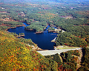
and Everett Lake. Everett Lake is part of the watershed
Drainage basin
A drainage basin is an extent or an area of land where surface water from rain and melting snow or ice converges to a single point, usually the exit of the basin, where the waters join another waterbody, such as a river, lake, reservoir, estuary, wetland, sea, or ocean...
-spanning Hopkinton-Everett flood
Flood
A flood is an overflow of an expanse of water that submerges land. The EU Floods directive defines a flood as a temporary covering by water of land not normally covered by water...
control reservoir — a canal spanning the drainage divide connects Everett Lake to Hopkinton Reservoir, which impounds the Contoocook River
Contoocook River
The Contoocook River is a river in New Hampshire. It flows from Pool Pond and Contoocook Lake on the Jaffrey/Rindge border to Penacook , where it empties into the Merrimack River. It is one of only a few rivers in New Hampshire that flow in a predominantly northward direction...
.
The Piscataquog proceeds south from the Everett Dam along the eastern side of Weare, entering Goffstown
Goffstown, New Hampshire
Goffstown is a town in Hillsborough County, New Hampshire, United States. The population was 17,651 at the 2010 census. The compact center of town, where 3,196 people resided at the 2010 census, is defined by the U.S. Census Bureau as the Goffstown census-designated place and is located at the...
shortly before the river's junction with the South Branch
South Branch Piscataquog River
The South Branch of the Piscataquog River is a river located in southern New Hampshire in the United States. It is a tributary of the Piscataquog River, part of the Merrimack River watershed....
, the Piscataquog's largest tributary. From Goffstown to the river's mouth there are two small reservoirs and several additional dams, each constructed for hydroelectric power or older industrial development. In west Manchester, the Piscataquog passes under the Nazaire Biron Bridge and reaches the Merrimack River just upstream of the Queen City Bridge.