
.gif)
Flint River (Michigan)
Encyclopedia
- For other rivers named Flint, see Flint RiverFlint RiverFlint River may refer to:In Jamaica*Flint River *Flint River In the United States*Flint River *Flint River *Flint River *Flint River...
(disambiguation page).
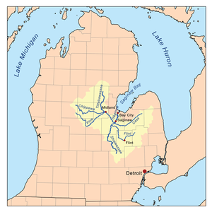
The Flint River is a 78.3 miles (126 km) river
River
A river is a natural watercourse, usually freshwater, flowing towards an ocean, a lake, a sea, or another river. In a few cases, a river simply flows into the ground or dries up completely before reaching another body of water. Small rivers may also be called by several other names, including...
in the Flint/Tri-Cities
Flint/Tri-Cities
The Flint/Tri-Cities Region or Saginaw Valley is a region in the Lower Peninsula of the U.S. state of Michigan. The region is composed of the area surrounding Flint, Michigan, the Tri Cities, the Saginaw Bay and Saginaw River . Flint's population is 102,434; it is the seventh largest city in Michigan...
region of Michigan
Michigan
Michigan is a U.S. state located in the Great Lakes Region of the United States of America. The name Michigan is the French form of the Ojibwa word mishigamaa, meaning "large water" or "large lake"....
in the United States
United States
The United States of America is a federal constitutional republic comprising fifty states and a federal district...
. It flows through the city of Flint
Flint, Michigan
Flint is a city in the U.S. state of Michigan and is located along the Flint River, northwest of Detroit. The U.S. Census Bureau reports the 2010 population to be placed at 102,434, making Flint the seventh largest city in Michigan. It is the county seat of Genesee County which lies in the...
and the counties of Genesee
Genesee County, Michigan
-Interstates:* I-69* I-75* I-475-Michigan State Trunklines:* M-13* M-15* M-21* M-54* M-57-Demographics:As of the census of 2000, there were 436,141 people, 169,825 households, and 115,990 families residing in the county. The population density was 682 people per square mile . There were 183,630...
, Lapeer
Lapeer County, Michigan
-Demographics:As of the census of 2000, there were 87,904 people, 30,729 households, and 23,876 families residing in the county. The population density was 134 people per square mile . There were 32,732 housing units at an average density of 50 per square mile...
and Saginaw
Saginaw County, Michigan
-Demographics:As of the census of 2000, there were 210,039 people, 80,430 households, and 55,818 families residing in the county. The population density was 260 people per square mile . There were 85,505 housing units at an average density of 106 per square mile...
.
Course
Lapeer County, Michigan
-Demographics:As of the census of 2000, there were 87,904 people, 30,729 households, and 23,876 families residing in the county. The population density was 134 people per square mile . There were 32,732 housing units at an average density of 50 per square mile...
, Genesee
Genesee County, Michigan
-Interstates:* I-69* I-75* I-475-Michigan State Trunklines:* M-13* M-15* M-21* M-54* M-57-Demographics:As of the census of 2000, there were 436,141 people, 169,825 households, and 115,990 families residing in the county. The population density was 682 people per square mile . There were 183,630...
, Shiawassee
Shiawassee County, Michigan
-Transportation:-Demographics:As of the census of 2000, there were 71,687 people, 26,896 households, and 19,849 families residing in the county. The population density was 133 people per square mile . There were 29,087 housing units at an average density of 54 per square mile...
, and Saginaw
Saginaw County, Michigan
-Demographics:As of the census of 2000, there were 210,039 people, 80,430 households, and 55,818 families residing in the county. The population density was 260 people per square mile . There were 85,505 housing units at an average density of 106 per square mile...
. It also drains parts of Oakland
Oakland County, Michigan
-Demographics:As of the 2010 Census, there were 1,202,362 people, 471,115 households, and 315,175 families residing in the county. The population density as of the 2000 census was 1,369 people per square mile . There were 492,006 housing units at an average density of 564 per square mile...
, Tuscola
Tuscola County, Michigan
-Highways:* M-15* M-24* M-25* M-46* M-81* M-138-Demographics:As of the census of 2000, there were 58,266 people, 21,454 households, and 15,983 families residing in the county. The population density was 72 people per square mile . There were 23,378 housing units at an average density of 29 per...
, and Sanilac
Sanilac County, Michigan
-Highways:* M-19* M-25* M-46* M-53* M-81* M-90-History:Sanilac County was probably named for a Wyandot chief named Sanilac. See List of Michigan county name etymologies....
counties.
The river is formed in Lapeer County near Columbiaville
Columbiaville, Michigan
Columbiaville is a village in Lapeer County in the U.S. state of Michigan. The population was 815 at the 2000 census. The village is within Marathon Township on the Flint River.-History:...
where the river's South Branch and North Branch come together. The river is supplemented by four major creeks, the Kearsley (draining the south and central portions of the east side of Genesee County), Thread (draining the south central part of the county), Swartz
Swartz Creek
Swartz Creek is a creek located in the Mid Michigan area in the United States. It is a tributary of the Flint River and has two branches, the East and West Branch. Its name comes from the German word Schwarz, meaning "black", as the creek water is muddy....
(draining the Swartz Creek
Swartz Creek, Michigan
-Demographics:At the 2000 census, there were 5,102 people, 2,233 households and 1,460 families residing in the city. The population density was 1,269.6 per square mile . There were 2,355 housing units at an average density of 586.0 per square mile...
area), and Misteguay (draining the area near the northern section of the border of Genesee and Shiawassee counties).
The river empties into the Shiawassee River
Shiawassee River
The Shiawassee River in the U.S. state of Michigan is long and generally flows in a northerly direction. It merges together with the Flint River, the Cass River and the Tittabawassee River to form the Saginaw River, which drains into the Saginaw Bay of Lake Huron.-Description:Supporting...
in the Shiawassee National Wildlife Refuge
Shiawassee National Wildlife Refuge
The Shiawassee National Wildlife Refuge is a 9,427 acre National Wildlife Refuge in Saginaw County managed by the United States Fish and Wildlife Service. It is located in the central portion of the lower peninsula of the U.S. state of Michigan, approximately 25 miles south of the Saginaw Bay in...
near the city of Saginaw
Saginaw, Michigan
Saginaw is a city in the U.S. state of Michigan and the seat of Saginaw County. The city of Saginaw was once a thriving lumber town and manufacturing center. Saginaw and Saginaw County lie in the Flint/Tri-Cities region of Michigan...
. Within the refuge, the Cass
Cass River
The Cass River is a river in the Thumb region of the U.S. state of Michigan. It drains large portions of Sanilac and Tuscola counties and smaller portions of Genesee, Huron, Lapeer, and Saginaw counties....
and Tittabawassee
Tittabawassee River
The Tittabawassee River is a stream which flows in a generally southeasterly direction through the Lower Peninsula of the U.S. state of Michigan. The river begins at Secord Lake in Clement Township, at the confluence of the East Branch and the Middle Branch...
rivers combine with the Shiawassee to form the Saginaw River
Saginaw River
The Saginaw River is a river in the U.S. state of Michigan. It is formed by the confluence of the Tittabawassee and Shiawassee rivers southwest of Saginaw. It flows northward into the Saginaw Bay of Lake Huron just northeast of Bay City. The watershed area is .The river is an important shipping...
. The Saginaw empties into the Saginaw Bay
Saginaw Bay
Saginaw Bay is a bay within Lake Huron located on the eastern side of the U.S. state of Michigan. It forms the space between Michigan's Thumb region and the rest of the Lower Peninsula of Michigan. Saginaw Bay is in area...
of Lake Huron
Lake Huron
Lake Huron is one of the five Great Lakes of North America. Hydrologically, it comprises the larger portion of Lake Michigan-Huron. It is bounded on the east by the Canadian province of Ontario and on the west by the state of Michigan in the United States...
.
Features along the Flint River
The river is damDam
A dam is a barrier that impounds water or underground streams. Dams generally serve the primary purpose of retaining water, while other structures such as floodgates or levees are used to manage or prevent water flow into specific land regions. Hydropower and pumped-storage hydroelectricity are...
med in Richfield Township
Richfield Township, Genesee County, Michigan
Richfield Township is a civil township of Genesee County in the U.S. state of Michigan. The population was 8,170 at the 2000 census.-Communities:* Richfield Center is a small unincorporated community with the township at M-15 and Coldwater Road....
to form the Holloway Reservoir, which was formed in 1953 and fully completed 1955. The reservoir was constructed, originally, as a water supply for Flint, and to move the river through the city more quickly to dilute sewage. By 1967, though, the city got its drinking water from Lake Huron, and only uses the reservoir as an emergency back-up water supply.
The C.S. Mott Dam just 5 miles (8 km) downstream and west of Genesee forms Mott Lake and was completed in 1972 for recreational use. Local attractions along the lake include Crossroads Village, Huckleberry Railroad, and Stepping Stone Falls, and the riverboat
Riverboat
A riverboat is a ship built boat designed for inland navigation on lakes, rivers, and artificial waterways. They are generally equipped and outfitted as work boats in one of the carrying trades, for freight or people transport, including luxury units constructed for entertainment enterprises, such...
Genesee Belle.
The next dam is the Utah Dam. A largely steel dam, it was completed in 1928 to prevent industrial discharges from entering the drinking water supply downstream. The gates have since been locked in the open position so that it no longer impedes the flow of the river.
The Hamilton Dam exists downstream at the University of Michigan–Flint campus in downtown Flint. Constructed in 1920, it once also served as a pedestrian bridge, but is now in severe disrepair. Because of its dilapidation, the Michigan Department of Environmental Quality ordered that steps be taken by 2008, and if that did not occur that the river be lowered to reduce the use of the dam. In 2008, the city of Flint spent $30,000 on a pre-engineering study to assess whether a new dam was needed or the old one be repaired.
Finally, downstream from the Hamilton Dam is an inflatable dam just west of the Grand Traverse Street Bridge. The Fabridam was completed in 1979 mostly for visual and recreational purposes as it impounds very little of the river. It was replaced in 2001 with a $604,000 Obermeyer Hydro Inc. dam.
In the city of Flint, the river flows past the sites of former General Motors factories, most notably Chevrolet
Chevrolet
Chevrolet , also known as Chevy , is a brand of vehicle produced by General Motors Company . Founded by Louis Chevrolet and ousted GM founder William C. Durant on November 3, 1911, General Motors acquired Chevrolet in 1918...
's first assembly plant, which was bisected by the river, and downtown through the campus of the University of Michigan–Flint and Riverbank Park. Continuing to the west, the river runs past Kettering University
Kettering University
Kettering University is a university in Flint, Michigan, offering degrees in engineering, math, science, and business. The campus is located along the Flint River on property that used to be the main manufacturing location for General Motors...
and McLaren Hospital out into Flint Township and Flushing
Flushing, Michigan
Flushing is a city in Genesee County in the U.S. state of Michigan. The population was 8,348 at the 2000 census. Flushing is considered a suburb of Flint. It is situated within the area of Flushing Charter Township, but is administratively autonomous...
. The stretch of the Flint River from downtown Flint to Kettering University is channelized with concrete sides. In downtown Flint, the Flint Carriage Factory is on the river, which was later Dort Motors
Dort (automobile)
The Dort was an automobile built by the Dort Motor Car Company of Flint, Michigan from 1915 - 1924. Dort used Lycoming built engines to power their vehicles....
, a predecessor to General Motors. The Durant-Dort Carriage Company Office
Durant-Dort Carriage Company Office
The Durant-Dort Carriage Company Office is a historic office building located at 316 West Water Street in Flint, Michigan. This office building was the focal point of William C. Durant's efforts in building first carriages and then automobiles, and is the only extant building closely associated...
, now a historic landmark, is across the street.
A recreational trail called the Flint River Trail runs along the river from Grand Traverse Street in downtown Flint to Carpenter Road on one side and Johnson Elementary School on Pierson Road on the other. It is a paved path, except behind the Flint water plant. North of Carpenter Road, the trail connects to the Mott Lake Trailway, which goes to Bluebell Beach on Bray Road and Stepping Stone Falls on Branch Road in Genesee Township. Another portion of the Mott Lake Trailway runs alongside the lake from the corner of Center Road and Coldwater Road to the corner of Genesee Road and Stanley Road. Together, the trails run 21.5 miles (34.6 km). An organization named Friends of the Flint River Trail maintains it, in addition to the Genesee County Parks & Recreation Commission and Flint Parks & Recreation Department.
Northwest of Flint, a city park in Flushing
Flushing, Michigan
Flushing is a city in Genesee County in the U.S. state of Michigan. The population was 8,348 at the 2000 census. Flushing is considered a suburb of Flint. It is situated within the area of Flushing Charter Township, but is administratively autonomous...
lies on the river, as well as the recreational Flushing River View Trail.
Cities and villages along the river
- Montrose, MichiganMontrose, MichiganMontrose is a city in Genesee County in the U.S. state of Michigan. The population was 1,619 at the 2000 census. The city is situated within Montrose Township, but is politically independent.- History :...
- Flushing, MichiganFlushing, MichiganFlushing is a city in Genesee County in the U.S. state of Michigan. The population was 8,348 at the 2000 census. Flushing is considered a suburb of Flint. It is situated within the area of Flushing Charter Township, but is administratively autonomous...
- Flint, MichiganFlint, MichiganFlint is a city in the U.S. state of Michigan and is located along the Flint River, northwest of Detroit. The U.S. Census Bureau reports the 2010 population to be placed at 102,434, making Flint the seventh largest city in Michigan. It is the county seat of Genesee County which lies in the...
- Genesee, Michigan
- Columbiaville, MichiganColumbiaville, MichiganColumbiaville is a village in Lapeer County in the U.S. state of Michigan. The population was 815 at the 2000 census. The village is within Marathon Township on the Flint River.-History:...
- Lapeer, MichiganLapeer, MichiganLapeer is a city in the U.S. state of Michigan and is the county seat of Lapeer County. As of the 2010 census, the city population was 8,841. Most of the city was incorporated from land that was formerly in Lapeer Township, though portions were also annexed from Mayfield Township and Elba...
External links
- Flint River assessment
- Maps and graphs of Michigan water resources conditions
- USGS Water Data Flint River water data near OtisvilleOtisville, MichiganOtisville is a village in Genesee County in the U.S. state of Michigan. The population was 882 at the 2000 census. The village is within Forest Township.-Geography:According to the United States Census Bureau, the village has a total area of...
- USGS Water Data Flint River near Flint
- Flint River Watershed Coalition
- USGS water data for the Flint River near its terminus