

U.S. Route 50
Encyclopedia
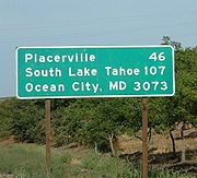
U.S. Route 50 is a major east–west route of the U.S. Highway system, stretching just over 3000 miles (4,828 km) from Ocean City, Maryland
on the Atlantic Ocean to West Sacramento, California
. Until 1972, when it was replaced by Interstate Highways west of the Sacramento area, it extended to San Francisco, near the Pacific Ocean. The route mostly remains separate from Interstates. It generally serves a corridor south of Interstates 70
and 80
and north of Interstates 64
and 40
. The route runs through mostly rural desert
and mountain
s in the Western United States
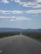
, with the section through Nevada
known as "The Loneliest Road in America". In the Midwest, US 50 continues through mostly rural areas of farms as well as a few large cities including Kansas City, Missouri
; St. Louis, Missouri
; and Cincinnati, Ohio
. The route continues into the Eastern United States, where it passes through the Appalachian Mountains
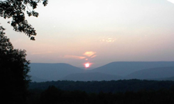
in West Virginia
before heading through Washington, D.C.
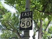
From there, US 50 continues through Maryland
as a high-speed road to Ocean City. Signs at each end give the length as 3073 miles (4,945.5 km), but the actual distance is slightly less, due to realignments since the former figure was measured. US 50 passes through a total of 12 states (California
, Nevada, Utah
, Colorado
, Kansas
, Missouri
, Illinois
, Indiana
, Ohio
, West Virginia, Virginia
, and Maryland) as well as the District of Columbia.
US 50 was created in 1926 as part of the original U.S. Highway system. The original route planned in 1925 ran from Wadsworth, Nevada
east to Annapolis, Maryland
along several auto trail
s including the Lincoln Highway
, Midland Trail
, and the National Old Trails Road. The final 1926 plan had US 50 running from Sacramento, California
east to Annapolis with a gap in west Utah that was bridged by running the route north via Salt Lake City
before rerouting it to U.S. Route 6
in the 1950s. US 50 was extended west from Sacramento to San Francisco in the 1930s, replacing U.S. Route 48; this was reversed in 1964 when Interstate 580
replaced much of the route between the two cities. In addition, US 50 was extended east from Annapolis to Ocean City prior to 1952, replacing a portion of U.S. Route 213. US 50 had two split configurations into U.S. Route 50N and U.S. Route 50S, one in Kansas and another in Ohio and West Virginia; both of these instances have been removed.
 US 50 begins as a major freeway at its junction with Interstate 80
in West Sacramento and continues into Sacramento
. The portion of US 50 west of and including its interchange with California's State Highway 99 in Sacramento is also designated, but not signed as, Interstate 305. The signage along this portion of the highway indicates Business Loop I-80 and a portion of the way (2 miles/3.33 km) as California State Highway 99. From Sacramento, the highway heads eastward as the William Alexander Leidesdorff, Jr. Memorial Highway, continuing as a freeway to the Gold Country
foothills, then following the American River
up the Sierra Nevada as a conventional highway, until cresting the Sierras at Echo Summit
and descending to Lake Tahoe
, where the highway enters Nevada
. In Nevada, the highway crosses a series of north–south running mountain ranges that break up the Nevada desert which are called Basin and Range
. East of Carson City
, the road enters the heart of the Great Basin
, passing by few communities and minimal services, giving it the name "Loneliest Road in America" until reaching Utah
.
In Utah, US 50 also passes through desolate, remote areas with few inhabitants. After crossing the Confusion Range
via Kings Canyon
and the House Range
, the road traverses the north shore of the endorheic Sevier Lake
. In Holden
, US 50 shortly overlaps Interstate 15
to cross the Pavant Range
. The road begins a much longer overlap with Interstate 70
in Salina
crossing the Wasatch Plateau and San Rafael Swell
into Colorado
. US 50 leaves I-70 upon entering the state and heads southeast through Grand Junction
and into the southern part of Colorado. Once there, the road climbs to its highest elevation of 11312 feet (3,447.9 m) over the Rocky Mountains
and in Monarch Pass
where it crosses the Continental Divide
. After descending from the Rockies, US 50 passes by Royal Gorge
near Cañon City then joins U.S. Route 400
in Granada
and follows the Arkansas River
through Pueblo
and into Kansas
.
 Upon entering Kansas, US 50, concurrent
with US 400, run along the Arkansas River to Dodge City where US 50 splits from US 400 and takes a more northerly course. US 50 continues to traverse the farmlands and small towns of the Great Plains
mostly as a straight two-lane road until Emporia where it joins Interstate 35
and splits onto Interstate 435 to bypass the center of the Kansas City Area
. In Missouri
, US 50 leaves I-435 for Interstate 470
splitting at Lee's Summit
. US 50 runs as a four-lane divided highway
across the Western Plain
to Sedalia where it continues as a two-lane road until reaching the shores of the Missouri River
in Jefferson City. The road then traverses the northern sections of the Ozark Highlands east to Union where it begins an overlap with Interstate 44
which goes through Pacific
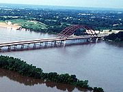
. The routes separate in Sunset Hills where US 50 migrates southeast bypassing St Louis by joining Interstate 255 to cross Mississippi River
into Illinois
.
In that state, US 50 switches to Interstate 64
before splitting onto its own alignment in eastern O'Fallon. It heads east through Salem, Flora and Lawrenceville to the Wabash River
along a corridor between Interstates 64
and 70
. US 50 enters Indiana
at the Wabash River, bypassing Vincennes and Washington and passing through Bedford, Seymour, and Versailles. It meets the Ohio River
at Aurora, and soon crosses into Ohio
, running through downtown Cincinnati via Fort Washington Way
(Interstate 71
). The route crosses southern Ohio via Hillsboro, Chillicothe, and Athens, joining the four-lane divided Corridor D (State Route 32) west of Athens. It meets the Ohio River, from which it split at Cincinnati, at Belpre, and crosses the Blennerhassett Island Bridge
(previously crossing the Parkersburg-Belpre Bridge) into Parkersburg, West Virginia
.
The portion of US 50 from Parkersburg, West Virginia
to Winchester, Virginia
follows the historic Northwestern Turnpike
, which crosses the southern tip of Garrett County, Maryland
. From Parkersburg to Interstate 79
east of Clarksburg, US 50 has been upgraded as part of the four-lane divided Corridor D. US 50 is a curving two-lane mountain road, east of Clarksburg through Grafton, a bit of Maryland, and Romney to Winchester. This portion of the road is so curvy that locals claim "you can meet yourself coming". The land flattens out after it crosses the Shenandoah Mountains
east of Winchester, and it follows the old Little River Turnpike from Aldie to Fairfax and the newer Arlington Boulevard
to Rosslyn, where it crosses the District of Columbia line on the west shore of the Potomac River
and joins Interstate 66
on the Roosevelt Bridge.
Within the District, US 50 immediately exits the freeway onto Constitution Avenue
along the north side of the National Mall
. After turning north on 6th Street Northwest, it exits the city to the northeast on New York Avenue
. Upon crossing into Maryland
, it passes the south end of the Baltimore-Washington Parkway
and becomes the John Hanson Highway, a freeway to Annapolis. The portion of this highway east of the Capital Beltway
(I-95
/I-495) is also designated, but not signed as, Interstate 595
, and U.S. Route 301
joins from the south at Bowie. The freeway continues beyond Annapolis as the Blue Star Memorial Highway which crosses Chesapeake Bay
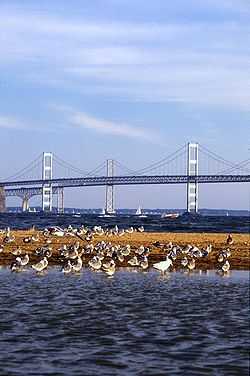
on the Chesapeake Bay Bridge
and continues to Queenstown. There the Blue Star Highway continues northeast as US 301, while US 50 turns south, passing through Easton to Cambridge, and then east through Salisbury to Ocean City on the four-lane divided Ocean Gateway. US 50 ends near the Atlantic Ocean shore
at Baltimore Avenue (Maryland Route 528
northbound); its westbound beginning is one block to the west, at Philadelphia Avenue (MD 528 southbound).
, US 50 was a major east–west route. Numbered highways in the United States follow a pattern of odd numbers for north–south routes and even numbers for east–west routes, hence the designation of "50" for this route. In the preliminary report, approved by the Joint Board on Interstate Highways in late 1925, US 50 ran from Wadsworth, Nevada
to Annapolis, Maryland
, passing through Pueblo, Colorado
, Kansas City, Missouri
, Tipton, Missouri
, St. Louis, Missouri
, Cincinnati, Ohio
, and Washington, D.C.
The route did not directly replace any auto trail
, instead combining portions of many into one continuous route. Major auto trails followed, included the Lincoln Highway
in Nevada
, the Midland Trail
in parts of Utah
and Colorado
and again in Missouri
, Illinois
, and part of Indiana
, and the National Old Trails Road (Old Santa Fe Trail) in eastern Colorado and Kansas
. It also followed the historic Northwestern Turnpike
across West Virginia
. In most states that had numbered their state highway
s, US 50 followed only one or two numbers across the state.
One major controversy erupted in relation to the preliminary route of US 50. The through route had been assigned to the Old Sante Fe Trail, while the spur U.S. Route 250 followed the competing New Santa Fe Trail to the south. As a compromise, the Joint Board on Interstate Highways approved a split configuration — U.S. Route 50N and U.S. Route 50S — in January. Another problem was in western Utah, where no improved road existed for US 50 to use. The final numbering plan, approved in November 1926, left a gap in US 50 between Ely, Nevada
and Thistle, Utah
. Finally, rather than ending US 50 at Wadsworth, where the Lincoln and Victory Highway
s merged, it was sent over the Lincoln Highway's Pioneer Branch, past the south side of Lake Tahoe
, to Sacramento, California
.
 The gap in Utah was soon bypassed by taking US 50 to the north, crossing the Great Salt Lake Desert
with U.S. Route 40
to Salt Lake City, and using long portions of U.S. Route 93
in Nevada and U.S. Route 89
in Utah. U.S. Route 6
was marked along the direct, but still partially unimproved, route in 1937; it was finally paved in 1952, and US 50 was moved to it within a few years. Another straightening was made in 1976, when US 50 in central Utah was moved south onto the new extension of Interstate 70
at the request of the National Highway 50 Federation, a group dedicated to promoting US 50. Among other things, the group has unsuccessfully pushed for an extension of Interstate 70
west along US 50 to California
.
The north–south split in Kansas was eliminated in the late 1950s, with the south route — which was to be US 250 — becoming part of US 50, and most of US 50N becoming part of a new U.S. Route 56
. Another split was located between Athens, Ohio
and Ellenboro, West Virginia
from the late 1920s to the mid-1930s, when US 50 went back to its original south route; that U.S. Route 50N is now Ohio State Route 550
and part of West Virginia Route 16.
At its west end, US 50 was extended south from Sacramento along U.S. Route 99
to Stockton and west to the San Francisco Bay Area
, replacing U.S. Route 48, by the early 1930s. US 50 was officially cut back to Sacramento in the 1964 renumbering, replaced by Interstate 580
, but remained on maps and signs for several more years. US 50 was extended east from Annapolis to Ocean City, Maryland
several years prior to the opening of the Chesapeake Bay Bridge
in 1952; this extension replaced much of U.S. Route 213.
Ocean City, Maryland
Ocean City, sometimes known as OC, or OCMD, is an Atlantic Ocean resort town in Worcester County, Maryland, United States. Ocean City is widely known in the Mid-Atlantic region of the United States and is a frequent destination for vacationers in that area...
on the Atlantic Ocean to West Sacramento, California
West Sacramento, California
West Sacramento is a city in Yolo County, California. It is contiguous with Sacramento, but is separated by the Sacramento River which is also the county line, so West Sacramento is in a different county than Sacramento...
. Until 1972, when it was replaced by Interstate Highways west of the Sacramento area, it extended to San Francisco, near the Pacific Ocean. The route mostly remains separate from Interstates. It generally serves a corridor south of Interstates 70
Interstate 70
Interstate 70 is an Interstate Highway in the United States that runs from Interstate 15 near Cove Fort, Utah, to a Park and Ride near Baltimore, Maryland. It was the first Interstate Highway project in the United States. I-70 approximately traces the path of U.S. Route 40 east of the Rocky...
and 80
Interstate 80
Interstate 80 is the second-longest Interstate Highway in the United States, following Interstate 90. It is a transcontinental artery running from downtown San Francisco, California to Teaneck, New Jersey in the New York City Metropolitan Area...
and north of Interstates 64
Interstate 64
Interstate 64 is an Interstate Highway in the Midwestern and Southeastern United States. Its western terminus is at I-70, U.S. 40, and U.S. 61 in Wentzville, Missouri. Its eastern terminus is at an interchange with I-264 and I-664 at Bowers Hill in Chesapeake, Virginia. As I-64 is concurrent with...
and 40
Interstate 40
Interstate 40 is the third-longest major east–west Interstate Highway in the United States, after I-90 and I-80. Its western end is at Interstate 15 in Barstow, California; its eastern end is at a concurrency of U.S. Route 117 and North Carolina Highway 132 in Wilmington, North Carolina...
. The route runs through mostly rural desert
Desert
A desert is a landscape or region that receives an extremely low amount of precipitation, less than enough to support growth of most plants. Most deserts have an average annual precipitation of less than...
and mountain
Mountain
Image:Himalaya_annotated.jpg|thumb|right|The Himalayan mountain range with Mount Everestrect 58 14 160 49 Chomo Lonzorect 200 28 335 52 Makalurect 378 24 566 45 Mount Everestrect 188 581 920 656 Tibetan Plateaurect 250 406 340 427 Rong River...
s in the Western United States
Western United States
.The Western United States, commonly referred to as the American West or simply "the West," traditionally refers to the region comprising the westernmost states of the United States. Because the U.S. expanded westward after its founding, the meaning of the West has evolved over time...
, with the section through Nevada
Nevada
Nevada is a state in the western, mountain west, and southwestern regions of the United States. With an area of and a population of about 2.7 million, it is the 7th-largest and 35th-most populous state. Over two-thirds of Nevada's people live in the Las Vegas metropolitan area, which contains its...
known as "The Loneliest Road in America". In the Midwest, US 50 continues through mostly rural areas of farms as well as a few large cities including Kansas City, Missouri
Kansas City, Missouri
Kansas City, Missouri is the largest city in the U.S. state of Missouri and is the anchor city of the Kansas City Metropolitan Area, the second largest metropolitan area in Missouri. It encompasses in parts of Jackson, Clay, Cass, and Platte counties...
; St. Louis, Missouri
St. Louis, Missouri
St. Louis is an independent city on the eastern border of Missouri, United States. With a population of 319,294, it was the 58th-largest U.S. city at the 2010 U.S. Census. The Greater St...
; and Cincinnati, Ohio
Cincinnati, Ohio
Cincinnati is a city in the U.S. state of Ohio. Cincinnati is the county seat of Hamilton County. Settled in 1788, the city is located to north of the Ohio River at the Ohio-Kentucky border, near Indiana. The population within city limits is 296,943 according to the 2010 census, making it Ohio's...
. The route continues into the Eastern United States, where it passes through the Appalachian Mountains
Appalachian Mountains
The Appalachian Mountains #Whether the stressed vowel is or ,#Whether the "ch" is pronounced as a fricative or an affricate , and#Whether the final vowel is the monophthong or the diphthong .), often called the Appalachians, are a system of mountains in eastern North America. The Appalachians...
in West Virginia
West Virginia
West Virginia is a state in the Appalachian and Southeastern regions of the United States, bordered by Virginia to the southeast, Kentucky to the southwest, Ohio to the northwest, Pennsylvania to the northeast and Maryland to the east...
before heading through Washington, D.C.
Washington, D.C.
Washington, D.C., formally the District of Columbia and commonly referred to as Washington, "the District", or simply D.C., is the capital of the United States. On July 16, 1790, the United States Congress approved the creation of a permanent national capital as permitted by the U.S. Constitution....
From there, US 50 continues through Maryland
Maryland
Maryland is a U.S. state located in the Mid Atlantic region of the United States, bordering Virginia, West Virginia, and the District of Columbia to its south and west; Pennsylvania to its north; and Delaware to its east...
as a high-speed road to Ocean City. Signs at each end give the length as 3073 miles (4,945.5 km), but the actual distance is slightly less, due to realignments since the former figure was measured. US 50 passes through a total of 12 states (California
California
California is a state located on the West Coast of the United States. It is by far the most populous U.S. state, and the third-largest by land area...
, Nevada, Utah
Utah
Utah is a state in the Western United States. It was the 45th state to join the Union, on January 4, 1896. Approximately 80% of Utah's 2,763,885 people live along the Wasatch Front, centering on Salt Lake City. This leaves vast expanses of the state nearly uninhabited, making the population the...
, Colorado
Colorado
Colorado is a U.S. state that encompasses much of the Rocky Mountains as well as the northeastern portion of the Colorado Plateau and the western edge of the Great Plains...
, Kansas
Kansas
Kansas is a US state located in the Midwestern United States. It is named after the Kansas River which flows through it, which in turn was named after the Kansa Native American tribe, which inhabited the area. The tribe's name is often said to mean "people of the wind" or "people of the south...
, Missouri
Missouri
Missouri is a US state located in the Midwestern United States, bordered by Iowa, Illinois, Kentucky, Tennessee, Arkansas, Oklahoma, Kansas and Nebraska. With a 2010 population of 5,988,927, Missouri is the 18th most populous state in the nation and the fifth most populous in the Midwest. It...
, Illinois
Illinois
Illinois is the fifth-most populous state of the United States of America, and is often noted for being a microcosm of the entire country. With Chicago in the northeast, small industrial cities and great agricultural productivity in central and northern Illinois, and natural resources like coal,...
, Indiana
Indiana
Indiana is a US state, admitted to the United States as the 19th on December 11, 1816. It is located in the Midwestern United States and Great Lakes Region. With 6,483,802 residents, the state is ranked 15th in population and 16th in population density. Indiana is ranked 38th in land area and is...
, Ohio
Ohio
Ohio is a Midwestern state in the United States. The 34th largest state by area in the U.S.,it is the 7th‑most populous with over 11.5 million residents, containing several major American cities and seven metropolitan areas with populations of 500,000 or more.The state's capital is Columbus...
, West Virginia, Virginia
Virginia
The Commonwealth of Virginia , is a U.S. state on the Atlantic Coast of the Southern United States. Virginia is nicknamed the "Old Dominion" and sometimes the "Mother of Presidents" after the eight U.S. presidents born there...
, and Maryland) as well as the District of Columbia.
US 50 was created in 1926 as part of the original U.S. Highway system. The original route planned in 1925 ran from Wadsworth, Nevada
Wadsworth, Nevada
Wadsworth is a census-designated place in Washoe County, Nevada, United States. The population was 881 at the 2000 census. It is part of the Reno–Sparks Metropolitan Statistical Area. The town was named for General James S. Wadsworth, a Civil War general killed at the battle of the...
east to Annapolis, Maryland
Annapolis, Maryland
Annapolis is the capital of the U.S. state of Maryland, as well as the county seat of Anne Arundel County. It had a population of 38,394 at the 2010 census and is situated on the Chesapeake Bay at the mouth of the Severn River, south of Baltimore and about east of Washington, D.C. Annapolis is...
along several auto trail
Auto trail
The system of auto trails was an informal network of marked routes that existed in the United States and Canada in the early part of the 20th century. Marked with colored bands on telephone poles, the trails were intended to help travellers in the early days of the automobile.Auto trails were...
s including the Lincoln Highway
Lincoln Highway
The Lincoln Highway was the first road across the United States of America.Conceived and promoted by entrepreneur Carl G. Fisher, the Lincoln Highway spanned coast-to-coast from Times Square in New York City to Lincoln Park in San Francisco, originally through 13 states: New York, New Jersey,...
, Midland Trail
Midland Trail
For the trail's section in West Virginia see: The Midland Trail in West Virginia.The Midland Trail, also called the Roosevelt Midland Trail, was a national auto trail spanning the United States from Washington, D.C...
, and the National Old Trails Road. The final 1926 plan had US 50 running from Sacramento, California
Sacramento, California
Sacramento is the capital city of the U.S. state of California and the county seat of Sacramento County. It is located at the confluence of the Sacramento River and the American River in the northern portion of California's expansive Central Valley. With a population of 466,488 at the 2010 census,...
east to Annapolis with a gap in west Utah that was bridged by running the route north via Salt Lake City
Salt Lake City, Utah
Salt Lake City is the capital and the most populous city of the U.S. state of Utah. The name of the city is often shortened to Salt Lake or SLC. With a population of 186,440 as of the 2010 Census, the city lies in the Salt Lake City metropolitan area, which has a total population of 1,124,197...
before rerouting it to U.S. Route 6
U.S. Route 6
U.S. Route 6 , also called the Grand Army of the Republic Highway, a name that honors an American Civil War veterans association, is a main route of the U.S. Highway system, running east-northeast from Bishop, California to Provincetown, Massachusetts. Until 1964, it continued south from Bishop to...
in the 1950s. US 50 was extended west from Sacramento to San Francisco in the 1930s, replacing U.S. Route 48; this was reversed in 1964 when Interstate 580
Interstate 580 (California)
Interstate 580 is an 80-mile east–west Interstate Highway in Northern California. The heavily traveled spur route of Interstate 80 runs from San Rafael in the San Francisco Bay Area to Interstate 5 near Tracy in the Central Valley...
replaced much of the route between the two cities. In addition, US 50 was extended east from Annapolis to Ocean City prior to 1952, replacing a portion of U.S. Route 213. US 50 had two split configurations into U.S. Route 50N and U.S. Route 50S, one in Kansas and another in Ohio and West Virginia; both of these instances have been removed.
Route description
Western U.S.
Interstate 80
Interstate 80 is the second-longest Interstate Highway in the United States, following Interstate 90. It is a transcontinental artery running from downtown San Francisco, California to Teaneck, New Jersey in the New York City Metropolitan Area...
in West Sacramento and continues into Sacramento
Sacramento
Sacramento is the capital of the state of California, in the United States of America.Sacramento may also refer to:- United States :*Sacramento County, California*Sacramento, Kentucky*Sacramento – San Joaquin River Delta...
. The portion of US 50 west of and including its interchange with California's State Highway 99 in Sacramento is also designated, but not signed as, Interstate 305. The signage along this portion of the highway indicates Business Loop I-80 and a portion of the way (2 miles/3.33 km) as California State Highway 99. From Sacramento, the highway heads eastward as the William Alexander Leidesdorff, Jr. Memorial Highway, continuing as a freeway to the Gold Country
Gold Country
Gold Country is a region in the central and northeastern part of California, United States. It is famed for the mineral deposits and gold mines that attracted waves of immigrants, known as the 49ers, during the 1849 California Gold Rush.-Geography:State Route 49 was built through the Gold Country,...
foothills, then following the American River
American River
The American River is a California watercourse noted as the site of Sutter's Mill, northwest of Placerville, California, where gold was found in 1848, leading to the California Gold Rush...
up the Sierra Nevada as a conventional highway, until cresting the Sierras at Echo Summit
Echo Summit
Echo Summit is a mountain pass located in eastern El Dorado County, California, USA. At an elevation of , it is the highest point on U.S...
and descending to Lake Tahoe
Lake Tahoe
Lake Tahoe is a large freshwater lake in the Sierra Nevada of the United States. At a surface elevation of , it is located along the border between California and Nevada, west of Carson City. Lake Tahoe is the largest alpine lake in North America. Its depth is , making it the USA's second-deepest...
, where the highway enters Nevada
Nevada
Nevada is a state in the western, mountain west, and southwestern regions of the United States. With an area of and a population of about 2.7 million, it is the 7th-largest and 35th-most populous state. Over two-thirds of Nevada's people live in the Las Vegas metropolitan area, which contains its...
. In Nevada, the highway crosses a series of north–south running mountain ranges that break up the Nevada desert which are called Basin and Range
Basin and Range
The Basin and Range Province is a vast physiographic region defined by a unique topographic expression. Basin and Range topography is characterized by abrupt changes in elevation, alternating between narrow faulted mountain chains and flat arid valleys or basins...
. East of Carson City
Carson City, Nevada
The Consolidated Municipality of Carson City is the capital of the state of Nevada. The words Consolidated Municipality refer to a series of changes in 1969 which abolished Ormsby County and merged all the settlements contained within its borders into Carson City. Since that time Carson City has...
, the road enters the heart of the Great Basin
Great Basin
The Great Basin is the largest area of contiguous endorheic watersheds in North America and is noted for its arid conditions and Basin and Range topography that varies from the North American low point at Badwater Basin to the highest point of the contiguous United States, less than away at the...
, passing by few communities and minimal services, giving it the name "Loneliest Road in America" until reaching Utah
Utah
Utah is a state in the Western United States. It was the 45th state to join the Union, on January 4, 1896. Approximately 80% of Utah's 2,763,885 people live along the Wasatch Front, centering on Salt Lake City. This leaves vast expanses of the state nearly uninhabited, making the population the...
.
In Utah, US 50 also passes through desolate, remote areas with few inhabitants. After crossing the Confusion Range
Confusion Range
The Confusion Range is a north-south trending mountain range in west-central Utah. It is bounded by Snake Valley to the west, Tule Valley to the east, the Great Salt Lake Desert to the north, and the Ferguson Desert to the south. The range trends into the Burbank Hills, Mountain Home Range, and...
via Kings Canyon
Kings Canyon (Utah)
Kings Canyon is a canyon within the Confusion Range in Millard County, Utah. US Highway 6/US Highway 50 runs through the windy canyon. The area in and around the canyon is unpopulated, and is only used by humans for transportation and some sheep herding....
and the House Range
House Range
The House Range is a north-south trending mountain range in west-central Utah. It is famous for Notch Peak, one of the tallest limestone cliffs in the world, and a fossil Lagerstätte of Cambrian age, which has an array of Burgess Shale type fauna, including Elrathia kingii, a trilobite that is...
, the road traverses the north shore of the endorheic Sevier Lake
Sevier Lake
Sevier Lake is an intermittent and endorheic lake which lies in the lowest part of the Sevier Desert, Millard County, Utah. Like Great Salt Lake and Utah Lake, it is a remnant of Pleistocene Lake Bonneville. Sevier Lake is fed primarily by the Beaver and Sevier rivers, and the additional inflow...
. In Holden
Holden, Utah
Holden is a town in Millard County, Utah, United States. The population was 400 at the 2000 census.-History:Holden was settled in 1855 by a group of ten families sent out by the LDS bishop of Fillmore. It was named for Elijah E...
, US 50 shortly overlaps Interstate 15
Interstate 15 in Utah
In the U.S. state of Utah, Interstate 15 runs north–south through the southwestern and central portions of the state, passing through many of the population centers of that state, including St. George, Provo, Salt Lake City, and Ogden, the latter three being part of the urban area known as...
to cross the Pavant Range
Pavant Range
The Pavant Range is a mountain range in central Utah east of Fillmore. The range is named for the Pahvant tribe, a branch of the Ute Indians. The tallest peak is Mine Camp Peak at . Most of the land in the Pavant range is part of Fishlake National Forest.-Transportation:The mountain range is...
. The road begins a much longer overlap with Interstate 70
Interstate 70 in Utah
Interstate 70 is a mainline route of the Interstate Highway System in the United States connecting Utah and Maryland. The Utah section runs east–west for across the central part of the state. Richfield is the largest Utah city served by the freeway, which does not serve or connect any urban areas...
in Salina
Salina, Utah
Salina is a city in Sevier County, Utah, United States. The population was 2,393 at the 2000 census.-History:The first permanent settlers moved into the area in 1864 at the direction of leaders of the Church of Jesus Christ of Latter-day Saints...
crossing the Wasatch Plateau and San Rafael Swell
San Rafael Swell
The San Rafael Swell is a large geologic feature located in south-central Utah, USA about 30 miles west of Green River, Utah. The San Rafael Swell, approximately by , consists of a giant dome-shaped anticline of sandstone, shale, and limestone that was pushed up during the Paleocene Laramide...
into Colorado
Colorado
Colorado is a U.S. state that encompasses much of the Rocky Mountains as well as the northeastern portion of the Colorado Plateau and the western edge of the Great Plains...
. US 50 leaves I-70 upon entering the state and heads southeast through Grand Junction
Grand Junction, Colorado
The City of Grand Junction is the largest city in western Colorado. It is a city with a council–manager government form that is the county seat and the most populous city of Mesa County, Colorado, United States. Grand Junction is situated west-southwest of the Colorado State Capitol in Denver. As...
and into the southern part of Colorado. Once there, the road climbs to its highest elevation of 11312 feet (3,447.9 m) over the Rocky Mountains
Rocky Mountains
The Rocky Mountains are a major mountain range in western North America. The Rocky Mountains stretch more than from the northernmost part of British Columbia, in western Canada, to New Mexico, in the southwestern United States...
and in Monarch Pass
Monarch Pass
Monarch Pass is a high mountain pass in the Rocky Mountains of south-central Colorado in the United States.The pass is located on the continental divide at the southern end of the Sawatch Range along the border between Gunnison and Chaffee counties, approximately west of the town of Salida. The...
where it crosses the Continental Divide
Continental Divide
The Continental Divide of the Americas, or merely the Continental Gulf of Division or Great Divide, is the name given to the principal, and largely mountainous, hydrological divide of the Americas that separates the watersheds that drain into the Pacific Ocean from those river systems that drain...
. After descending from the Rockies, US 50 passes by Royal Gorge
Royal Gorge
The Royal Gorge is a canyon on the Arkansas River near Cañon City, Colorado. With a width of at its base and a few hundred feet at its top, and a depth of in places, the 10-mile-long canyon is a narrow, steep gorge through the granite of Fremont Peak...
near Cañon City then joins U.S. Route 400
U.S. Route 400
U.S. Route 400 is a mostly east–west U.S. Highway, commissioned in 1994. Its route number is a "violation" of the usual AASHTO numbering scheme, as there is no US 0 or US 100....
in Granada
Granada, Colorado
Granada is a Statutory Town in Prowers County, Colorado, United States. The population was 640 at the 2000 census.-Geography:Granada is located at ....
and follows the Arkansas River
Arkansas River
The Arkansas River is a major tributary of the Mississippi River. The Arkansas generally flows to the east and southeast as it traverses the U.S. states of Colorado, Kansas, Oklahoma, and Arkansas. The river's initial basin starts in the Western United States in Colorado, specifically the Arkansas...
through Pueblo
Pueblo, Colorado
Pueblo is a Home Rule Municipality that is the county seat and the most populous city of Pueblo County, Colorado, United States. The population was 106,595 in 2010 census, making it the 246th most populous city in the United States....
and into Kansas
Kansas
Kansas is a US state located in the Midwestern United States. It is named after the Kansas River which flows through it, which in turn was named after the Kansa Native American tribe, which inhabited the area. The tribe's name is often said to mean "people of the wind" or "people of the south...
.
Midwestern U.S.
Concurrency (road)
A concurrency, overlap, or coincidence in a road network is an instance of one physical road bearing two or more different highway, motorway, or other route numbers...
with US 400, run along the Arkansas River to Dodge City where US 50 splits from US 400 and takes a more northerly course. US 50 continues to traverse the farmlands and small towns of the Great Plains
Great Plains
The Great Plains are a broad expanse of flat land, much of it covered in prairie, steppe and grassland, which lies west of the Mississippi River and east of the Rocky Mountains in the United States and Canada. This area covers parts of the U.S...
mostly as a straight two-lane road until Emporia where it joins Interstate 35
Interstate 35
Interstate 35 is a north–south Interstate Highway in the central United States. I-35 stretches from Laredo, Texas, on the U.S.-Mexico border to Duluth, Minnesota, at Minnesota Highway 61 and 26th Avenue East. Many interstates used to have splits or spurs indicated with suffixed letters , but I-35...
and splits onto Interstate 435 to bypass the center of the Kansas City Area
Kansas City Metropolitan Area
The Kansas City Metropolitan Area is a fifteen-county metropolitan area that is anchored by Kansas City, Missouri and is bisected by the border between the states of Missouri and Kansas. As of the 2010 Census, the metropolitan area has a population of 2,035,334. The metropolitan area is the...
. In Missouri
Missouri
Missouri is a US state located in the Midwestern United States, bordered by Iowa, Illinois, Kentucky, Tennessee, Arkansas, Oklahoma, Kansas and Nebraska. With a 2010 population of 5,988,927, Missouri is the 18th most populous state in the nation and the fifth most populous in the Midwest. It...
, US 50 leaves I-435 for Interstate 470
Interstate 470 (Missouri)
Interstate 470 is a loop of the Interstate Highway System that serves to link southeast Kansas City to Independence via Lee's Summit in Jackson County, Missouri. The western terminus of the freeway is at the Grandview Triangle interchange while the northern terminus is an cloverleaf interchange...
splitting at Lee's Summit
Lee's Summit, Missouri
Lee's Summit is a city in the U.S. state of Missouri, and is contained within the counties of Jackson and Cass. As of the 2010 census found the population at 91,364 making it the sixth-largest city in the Kansas City Metropolitan Area and the sixth-largest city in Missouri...
. US 50 runs as a four-lane divided highway
Divided Highway
Divided Highway is a compilation album by American rock band The Doobie Brothers, released in 2003. . All tracks are taken from the albums Cycles and Brotherhood .-Track listing:...
across the Western Plain
Geography of Missouri
Missouri, a state near the geographical center of the United States, has three distinct physiographic divisions:* a north-western upland plain or prairie region part of the Interior Plains' Central Lowland known as the northern plains* a lowland in the extreme southeast bootheel region of...
to Sedalia where it continues as a two-lane road until reaching the shores of the Missouri River
Missouri River
The Missouri River flows through the central United States, and is a tributary of the Mississippi River. It is the longest river in North America and drains the third largest area, though only the thirteenth largest by discharge. The Missouri's watershed encompasses most of the American Great...
in Jefferson City. The road then traverses the northern sections of the Ozark Highlands east to Union where it begins an overlap with Interstate 44
Interstate 44
Interstate 44 is a major highway in the central United States. Its western terminus is in Wichita Falls, Texas at a concurrency with US 277, US 281 and US 287; its eastern terminus is at the Illinois state line on the Poplar Street Bridge over the Mississippi River in St...
which goes through Pacific
Pacific, Missouri
Pacific is a city in Franklin and St. Louis counties in the U.S. state of Missouri. The population was 7,002 at the 2010 census.-Geography:Pacific is located at . The city straddles the Franklin County/St. Louis County line, which lies halfway on the blocks between Elm and Neosho streets. St...
. The routes separate in Sunset Hills where US 50 migrates southeast bypassing St Louis by joining Interstate 255 to cross Mississippi River
Mississippi River
The Mississippi River is the largest river system in North America. Flowing entirely in the United States, this river rises in western Minnesota and meanders slowly southwards for to the Mississippi River Delta at the Gulf of Mexico. With its many tributaries, the Mississippi's watershed drains...
into Illinois
Illinois
Illinois is the fifth-most populous state of the United States of America, and is often noted for being a microcosm of the entire country. With Chicago in the northeast, small industrial cities and great agricultural productivity in central and northern Illinois, and natural resources like coal,...
.
In that state, US 50 switches to Interstate 64
Interstate 64
Interstate 64 is an Interstate Highway in the Midwestern and Southeastern United States. Its western terminus is at I-70, U.S. 40, and U.S. 61 in Wentzville, Missouri. Its eastern terminus is at an interchange with I-264 and I-664 at Bowers Hill in Chesapeake, Virginia. As I-64 is concurrent with...
before splitting onto its own alignment in eastern O'Fallon. It heads east through Salem, Flora and Lawrenceville to the Wabash River
Wabash River
The Wabash River is a river in the Midwestern United States that flows southwest from northwest Ohio near Fort Recovery across northern Indiana to southern Illinois, where it forms the Illinois-Indiana border before draining into the Ohio River, of which it is the largest northern tributary...
along a corridor between Interstates 64
Interstate 64
Interstate 64 is an Interstate Highway in the Midwestern and Southeastern United States. Its western terminus is at I-70, U.S. 40, and U.S. 61 in Wentzville, Missouri. Its eastern terminus is at an interchange with I-264 and I-664 at Bowers Hill in Chesapeake, Virginia. As I-64 is concurrent with...
and 70
Interstate 70
Interstate 70 is an Interstate Highway in the United States that runs from Interstate 15 near Cove Fort, Utah, to a Park and Ride near Baltimore, Maryland. It was the first Interstate Highway project in the United States. I-70 approximately traces the path of U.S. Route 40 east of the Rocky...
. US 50 enters Indiana
Indiana
Indiana is a US state, admitted to the United States as the 19th on December 11, 1816. It is located in the Midwestern United States and Great Lakes Region. With 6,483,802 residents, the state is ranked 15th in population and 16th in population density. Indiana is ranked 38th in land area and is...
at the Wabash River, bypassing Vincennes and Washington and passing through Bedford, Seymour, and Versailles. It meets the Ohio River
Ohio River
The Ohio River is the largest tributary, by volume, of the Mississippi River. At the confluence, the Ohio is even bigger than the Mississippi and, thus, is hydrologically the main stream of the whole river system, including the Allegheny River further upstream...
at Aurora, and soon crosses into Ohio
Ohio
Ohio is a Midwestern state in the United States. The 34th largest state by area in the U.S.,it is the 7th‑most populous with over 11.5 million residents, containing several major American cities and seven metropolitan areas with populations of 500,000 or more.The state's capital is Columbus...
, running through downtown Cincinnati via Fort Washington Way
Fort Washington Way
Fort Washington Way is a one-mile section of freeway in downtown Cincinnati, Ohio. Running east-west in a trench, it carries Interstate 71 and US-50, first built between 1958 and 1961. It is named for a former fort which once stood nearby....
(Interstate 71
Interstate 71
Interstate 71 is an Interstate Highway in the Great Lakes/Midwestern and Southeastern region of the United States. Its southern terminus is at an interchange with Interstate 64 and Interstate 65 in Louisville, Kentucky. Its northern terminus is at an interchange with Interstate 90 in Cleveland,...
). The route crosses southern Ohio via Hillsboro, Chillicothe, and Athens, joining the four-lane divided Corridor D (State Route 32) west of Athens. It meets the Ohio River, from which it split at Cincinnati, at Belpre, and crosses the Blennerhassett Island Bridge
Blennerhassett Island Bridge
Blennerhassett Island Bridge opened to traffic June 13, 2008. The bridge is a Network Arch Bridge constructed at a cost of $120 million over the Ohio River between Belpre, Ohio and Parkersburg, West Virginia. Construction of the bridge was completed by the Walsh Construction Company of Chicago.The...
(previously crossing the Parkersburg-Belpre Bridge) into Parkersburg, West Virginia
Parkersburg, West Virginia
As of the census of 2000, there were 33,099 people, 14,467 households, and 8,767 families residing in the city. In 2006 the U.S. Census Bureau estimated that Parkersburg's population had decreased 4.4% to 31,755. The population density was 2,800.5 people per square mile . There were 16,100 housing...
.
Mid-Atlantic states
The portion of US 50 from Parkersburg, West Virginia
Parkersburg, West Virginia
As of the census of 2000, there were 33,099 people, 14,467 households, and 8,767 families residing in the city. In 2006 the U.S. Census Bureau estimated that Parkersburg's population had decreased 4.4% to 31,755. The population density was 2,800.5 people per square mile . There were 16,100 housing...
to Winchester, Virginia
Winchester, Virginia
Winchester is an independent city located in the northwestern portion of the Commonwealth of Virginia in the USA. The city's population was 26,203 according to the 2010 Census...
follows the historic Northwestern Turnpike
Northwestern Turnpike
The Northwestern Turnpike is a historic road in West Virginia , important for being historically one of the major roads crossing the Appalachians, financed by the Virginia Board of Public Works in the 1830s. In modern times, west of Winchester, Virginia, U.S...
, which crosses the southern tip of Garrett County, Maryland
Garrett County, Maryland
Garrett County is the westernmost county of the U.S. state of Maryland. Created from Allegany County, Maryland in 1872 it was the last Maryland county to be formed. It was named for John Work Garrett , railroad executive, industrialist, and financier. Garrett served as president of the Baltimore...
. From Parkersburg to Interstate 79
Interstate 79
Interstate 79 is an Interstate Highway in the eastern United States, designated from Interstate 77 in Charleston, West Virginia to Pennsylvania Route 5 and Pennsylvania Route 290 in Erie, Pennsylvania...
east of Clarksburg, US 50 has been upgraded as part of the four-lane divided Corridor D. US 50 is a curving two-lane mountain road, east of Clarksburg through Grafton, a bit of Maryland, and Romney to Winchester. This portion of the road is so curvy that locals claim "you can meet yourself coming". The land flattens out after it crosses the Shenandoah Mountains
Shenandoah Mountains
Shenandoah Mountain is a mountain ridge approximately long in Virginia and West Virginia. The steep, narrow, sandstone-capped ridge extends from northern Bath County, Virginia to southern Hardy County, West Virginia...
east of Winchester, and it follows the old Little River Turnpike from Aldie to Fairfax and the newer Arlington Boulevard
Arlington Boulevard
Arlington Boulevard is a major arterial road in Arlington County, Fairfax County, and the independent City of Fairfax in Northern Virginia in metropolitan Washington, DC, United States. It is designated U.S...
to Rosslyn, where it crosses the District of Columbia line on the west shore of the Potomac River
Potomac River
The Potomac River flows into the Chesapeake Bay, located along the mid-Atlantic coast of the United States. The river is approximately long, with a drainage area of about 14,700 square miles...
and joins Interstate 66
Interstate 66
Interstate 66 is an Interstate Highway in the eastern United States. As indicated by its even route number, it runs in an east–west direction. Its western terminus is at Middletown, Virginia, at an intersection with Interstate 81; its eastern terminus is in Washington, D.C., at an...
on the Roosevelt Bridge.
Within the District, US 50 immediately exits the freeway onto Constitution Avenue
Constitution Avenue
In Washington, D.C., Constitution Avenue is a major east-west street running just north of the United States Capitol in the city's Northwest and Northeast quadrants...
along the north side of the National Mall
National Mall
The National Mall is an open-area national park in downtown Washington, D.C., the capital of the United States. The National Mall is a unit of the National Park Service , and is administered by the National Mall and Memorial Parks unit...
. After turning north on 6th Street Northwest, it exits the city to the northeast on New York Avenue
New York Avenue (Washington, D.C.)
New York Avenue is one of the diagonal avenues radiating from the White House in Washington, D.C. It is a major east-west route in the city's Northwest and Northeast quadrants and connects downtown with points east and north of the city via Cheverly, Maryland, the John Hanson Highway and the...
. Upon crossing into Maryland
Maryland
Maryland is a U.S. state located in the Mid Atlantic region of the United States, bordering Virginia, West Virginia, and the District of Columbia to its south and west; Pennsylvania to its north; and Delaware to its east...
, it passes the south end of the Baltimore-Washington Parkway
Baltimore-Washington Parkway
The Baltimore–Washington Parkway is a highway in the U.S. state of Maryland, running southwest from Baltimore to Washington, D.C. The road begins at an interchange with U.S. Route 50 and Maryland Route 201 near Cheverly in Prince George's County at the D.C...
and becomes the John Hanson Highway, a freeway to Annapolis. The portion of this highway east of the Capital Beltway
Interstate 495 (Capital Beltway)
Interstate 495 is a Interstate Highway that surrounds the United States' capital of Washington, D.C., and its inner suburbs in adjacent Maryland and Virginia. I-495 is widely known as the Capital Beltway or simply the Beltway, especially when the context of Washington, D.C., is clear...
(I-95
Interstate 95 in Maryland
Interstate 95 in Maryland is a major highway that runs diagonally from northeast to southwest, from Maryland's border with Delaware, to the Woodrow Wilson Bridge, briefly entering the District of Columbia before reaching Virginia...
/I-495) is also designated, but not signed as, Interstate 595
Interstate 595 (Maryland)
Interstate 595 is an unsigned number for a section of the John Hanson Highway from Interstate 495 east of Washington, D.C. to Maryland Route 70 at Annapolis, Maryland....
, and U.S. Route 301
U.S. Route 301
U.S. Route 301 is a spur of U.S. Route 1 running through the South Atlantic States. It currently runs 1,099 miles from Glasgow, Delaware at U.S. Route 40 to Sarasota, Florida. It passes through the states of Delaware, Maryland, Virginia, North Carolina, South Carolina, Georgia, and Florida...
joins from the south at Bowie. The freeway continues beyond Annapolis as the Blue Star Memorial Highway which crosses Chesapeake Bay
Chesapeake Bay
The Chesapeake Bay is the largest estuary in the United States. It lies off the Atlantic Ocean, surrounded by Maryland and Virginia. The Chesapeake Bay's drainage basin covers in the District of Columbia and parts of six states: New York, Pennsylvania, Delaware, Maryland, Virginia, and West...
on the Chesapeake Bay Bridge
Chesapeake Bay Bridge
The Chesapeake Bay Bridge is a major dual-span bridge in the U.S. state of Maryland. Spanning the Chesapeake Bay, it connects the state's rural Eastern Shore region with the more urban Western Shore. The original span opened in 1952 and, at the time, with a length of , it was the world's longest...
and continues to Queenstown. There the Blue Star Highway continues northeast as US 301, while US 50 turns south, passing through Easton to Cambridge, and then east through Salisbury to Ocean City on the four-lane divided Ocean Gateway. US 50 ends near the Atlantic Ocean shore
Atlantic Ocean
The Atlantic Ocean is the second-largest of the world's oceanic divisions. With a total area of about , it covers approximately 20% of the Earth's surface and about 26% of its water surface area...
at Baltimore Avenue (Maryland Route 528
Maryland Route 528
Maryland Route 528 is a state highway in the U.S. state of Maryland. Known for most of its length as Coastal Highway, the state highway runs from the southern terminus of its companion route, unsigned Maryland Route 378, in downtown Ocean City north to the Delaware state line at the northern...
northbound); its westbound beginning is one block to the west, at Philadelphia Avenue (MD 528 southbound).
History
Before the creation of the Interstate Highway SystemInterstate Highway System
The Dwight D. Eisenhower National System of Interstate and Defense Highways, , is a network of limited-access roads including freeways, highways, and expressways forming part of the National Highway System of the United States of America...
, US 50 was a major east–west route. Numbered highways in the United States follow a pattern of odd numbers for north–south routes and even numbers for east–west routes, hence the designation of "50" for this route. In the preliminary report, approved by the Joint Board on Interstate Highways in late 1925, US 50 ran from Wadsworth, Nevada
Wadsworth, Nevada
Wadsworth is a census-designated place in Washoe County, Nevada, United States. The population was 881 at the 2000 census. It is part of the Reno–Sparks Metropolitan Statistical Area. The town was named for General James S. Wadsworth, a Civil War general killed at the battle of the...
to Annapolis, Maryland
Annapolis, Maryland
Annapolis is the capital of the U.S. state of Maryland, as well as the county seat of Anne Arundel County. It had a population of 38,394 at the 2010 census and is situated on the Chesapeake Bay at the mouth of the Severn River, south of Baltimore and about east of Washington, D.C. Annapolis is...
, passing through Pueblo, Colorado
Pueblo, Colorado
Pueblo is a Home Rule Municipality that is the county seat and the most populous city of Pueblo County, Colorado, United States. The population was 106,595 in 2010 census, making it the 246th most populous city in the United States....
, Kansas City, Missouri
Kansas City, Missouri
Kansas City, Missouri is the largest city in the U.S. state of Missouri and is the anchor city of the Kansas City Metropolitan Area, the second largest metropolitan area in Missouri. It encompasses in parts of Jackson, Clay, Cass, and Platte counties...
, Tipton, Missouri
Tipton, Missouri
Tipton is a city in Moniteau County, Missouri, United States. The population was 3,261 at the 2000 census. It is part of the Jefferson City, Missouri Metropolitan Statistical Area.-Geography:Tipton is located at ....
, St. Louis, Missouri
St. Louis, Missouri
St. Louis is an independent city on the eastern border of Missouri, United States. With a population of 319,294, it was the 58th-largest U.S. city at the 2010 U.S. Census. The Greater St...
, Cincinnati, Ohio
Cincinnati, Ohio
Cincinnati is a city in the U.S. state of Ohio. Cincinnati is the county seat of Hamilton County. Settled in 1788, the city is located to north of the Ohio River at the Ohio-Kentucky border, near Indiana. The population within city limits is 296,943 according to the 2010 census, making it Ohio's...
, and Washington, D.C.
Washington, D.C.
Washington, D.C., formally the District of Columbia and commonly referred to as Washington, "the District", or simply D.C., is the capital of the United States. On July 16, 1790, the United States Congress approved the creation of a permanent national capital as permitted by the U.S. Constitution....
The route did not directly replace any auto trail
Auto trail
The system of auto trails was an informal network of marked routes that existed in the United States and Canada in the early part of the 20th century. Marked with colored bands on telephone poles, the trails were intended to help travellers in the early days of the automobile.Auto trails were...
, instead combining portions of many into one continuous route. Major auto trails followed, included the Lincoln Highway
Lincoln Highway
The Lincoln Highway was the first road across the United States of America.Conceived and promoted by entrepreneur Carl G. Fisher, the Lincoln Highway spanned coast-to-coast from Times Square in New York City to Lincoln Park in San Francisco, originally through 13 states: New York, New Jersey,...
in Nevada
Nevada
Nevada is a state in the western, mountain west, and southwestern regions of the United States. With an area of and a population of about 2.7 million, it is the 7th-largest and 35th-most populous state. Over two-thirds of Nevada's people live in the Las Vegas metropolitan area, which contains its...
, the Midland Trail
Midland Trail
For the trail's section in West Virginia see: The Midland Trail in West Virginia.The Midland Trail, also called the Roosevelt Midland Trail, was a national auto trail spanning the United States from Washington, D.C...
in parts of Utah
Utah
Utah is a state in the Western United States. It was the 45th state to join the Union, on January 4, 1896. Approximately 80% of Utah's 2,763,885 people live along the Wasatch Front, centering on Salt Lake City. This leaves vast expanses of the state nearly uninhabited, making the population the...
and Colorado
Colorado
Colorado is a U.S. state that encompasses much of the Rocky Mountains as well as the northeastern portion of the Colorado Plateau and the western edge of the Great Plains...
and again in Missouri
Missouri
Missouri is a US state located in the Midwestern United States, bordered by Iowa, Illinois, Kentucky, Tennessee, Arkansas, Oklahoma, Kansas and Nebraska. With a 2010 population of 5,988,927, Missouri is the 18th most populous state in the nation and the fifth most populous in the Midwest. It...
, Illinois
Illinois
Illinois is the fifth-most populous state of the United States of America, and is often noted for being a microcosm of the entire country. With Chicago in the northeast, small industrial cities and great agricultural productivity in central and northern Illinois, and natural resources like coal,...
, and part of Indiana
Indiana
Indiana is a US state, admitted to the United States as the 19th on December 11, 1816. It is located in the Midwestern United States and Great Lakes Region. With 6,483,802 residents, the state is ranked 15th in population and 16th in population density. Indiana is ranked 38th in land area and is...
, and the National Old Trails Road (Old Santa Fe Trail) in eastern Colorado and Kansas
Kansas
Kansas is a US state located in the Midwestern United States. It is named after the Kansas River which flows through it, which in turn was named after the Kansa Native American tribe, which inhabited the area. The tribe's name is often said to mean "people of the wind" or "people of the south...
. It also followed the historic Northwestern Turnpike
Northwestern Turnpike
The Northwestern Turnpike is a historic road in West Virginia , important for being historically one of the major roads crossing the Appalachians, financed by the Virginia Board of Public Works in the 1830s. In modern times, west of Winchester, Virginia, U.S...
across West Virginia
West Virginia
West Virginia is a state in the Appalachian and Southeastern regions of the United States, bordered by Virginia to the southeast, Kentucky to the southwest, Ohio to the northwest, Pennsylvania to the northeast and Maryland to the east...
. In most states that had numbered their state highway
State highway
State highway, state road or state route can refer to one of three related concepts, two of them related to a state or provincial government in a country that is divided into states or provinces :#A...
s, US 50 followed only one or two numbers across the state.
One major controversy erupted in relation to the preliminary route of US 50. The through route had been assigned to the Old Sante Fe Trail, while the spur U.S. Route 250 followed the competing New Santa Fe Trail to the south. As a compromise, the Joint Board on Interstate Highways approved a split configuration — U.S. Route 50N and U.S. Route 50S — in January. Another problem was in western Utah, where no improved road existed for US 50 to use. The final numbering plan, approved in November 1926, left a gap in US 50 between Ely, Nevada
Ely, Nevada
Ely is the largest city and county seat of White Pine County, Nevada, United States. Ely was founded as a stagecoach station along the Pony Express and Central Overland Route. Ely's mining boom came later than the other towns along US 50, with the discovery of copper in 1906...
and Thistle, Utah
Thistle, Utah
Thistle is a ghost town in Utah County, Utah, United States, about southeast of Salt Lake City. During the era of steam locomotives, the town's primary industry was servicing trains for the Denver and Rio Grande Western Railroad...
. Finally, rather than ending US 50 at Wadsworth, where the Lincoln and Victory Highway
Victory Highway
The Victory Highway was an auto trail across the United States between New York City and San Francisco, roughly equivalent to the present U.S. Route 40.-History:...
s merged, it was sent over the Lincoln Highway's Pioneer Branch, past the south side of Lake Tahoe
Lake Tahoe
Lake Tahoe is a large freshwater lake in the Sierra Nevada of the United States. At a surface elevation of , it is located along the border between California and Nevada, west of Carson City. Lake Tahoe is the largest alpine lake in North America. Its depth is , making it the USA's second-deepest...
, to Sacramento, California
Sacramento, California
Sacramento is the capital city of the U.S. state of California and the county seat of Sacramento County. It is located at the confluence of the Sacramento River and the American River in the northern portion of California's expansive Central Valley. With a population of 466,488 at the 2010 census,...
.
Great Salt Lake Desert
The Great Salt Lake Desert is a large dry lake in northern Utah between the Great Salt Lake and the Nevada border which is noted for white sand from evaporite Lake Bonneville salt deposits...
with U.S. Route 40
U.S. Route 40
U.S. Route 40 is an east–west United States highway. As with most routes whose numbers end in a zero, U.S. 40 once traversed the entire United States. It is one of the original 1920s U.S. Highways, and its first termini were San Francisco, California, and Atlantic City, New Jersey...
to Salt Lake City, and using long portions of U.S. Route 93
U.S. Route 93
U.S. Route 93 is a major north–south United States highway in the western United States. The southern terminus is at U.S. Route 60 in Wickenburg, Arizona. The northern terminus is at the Canadian border north of Eureka in Lincoln County, Montana, where the roadway continues into Roosville,...
in Nevada and U.S. Route 89
U.S. Route 89
U.S. Route 89 is a north–south United States Highway with two sections, and one former section. The southern section runs for 848 miles from Flagstaff, Arizona, to the southern entrance of Yellowstone National Park...
in Utah. U.S. Route 6
U.S. Route 6
U.S. Route 6 , also called the Grand Army of the Republic Highway, a name that honors an American Civil War veterans association, is a main route of the U.S. Highway system, running east-northeast from Bishop, California to Provincetown, Massachusetts. Until 1964, it continued south from Bishop to...
was marked along the direct, but still partially unimproved, route in 1937; it was finally paved in 1952, and US 50 was moved to it within a few years. Another straightening was made in 1976, when US 50 in central Utah was moved south onto the new extension of Interstate 70
Interstate 70
Interstate 70 is an Interstate Highway in the United States that runs from Interstate 15 near Cove Fort, Utah, to a Park and Ride near Baltimore, Maryland. It was the first Interstate Highway project in the United States. I-70 approximately traces the path of U.S. Route 40 east of the Rocky...
at the request of the National Highway 50 Federation, a group dedicated to promoting US 50. Among other things, the group has unsuccessfully pushed for an extension of Interstate 70
Interstate 70
Interstate 70 is an Interstate Highway in the United States that runs from Interstate 15 near Cove Fort, Utah, to a Park and Ride near Baltimore, Maryland. It was the first Interstate Highway project in the United States. I-70 approximately traces the path of U.S. Route 40 east of the Rocky...
west along US 50 to California
California
California is a state located on the West Coast of the United States. It is by far the most populous U.S. state, and the third-largest by land area...
.
The north–south split in Kansas was eliminated in the late 1950s, with the south route — which was to be US 250 — becoming part of US 50, and most of US 50N becoming part of a new U.S. Route 56
U.S. Route 56
U.S. Route 56 is an east–west United States highway that runs for in the Midwestern United States. The highway's eastern terminus is at U.S. Route 71 in Kansas City, Missouri. Its western terminus is at Interstate 25 Business in Springer, New Mexico. Much of it follows the Santa Fe...
. Another split was located between Athens, Ohio
Athens, Ohio
Athens is the largest city in, and the county seat of, Athens County, Ohio, United States. It is located along the Hocking River in the southeastern part of Ohio. A historic college town, Athens is home to Ohio University and is the principal city of the Athens, Ohio Micropolitan Statistical Area. ...
and Ellenboro, West Virginia
Ellenboro, West Virginia
Ellenboro is a town in Ritchie County, West Virginia, United States. The population was 373 at the 2000 census. The town is located at the junction of U.S. Route 50 and West Virginia Route 16; the North Bend Rail Trail also passes through the town...
from the late 1920s to the mid-1930s, when US 50 went back to its original south route; that U.S. Route 50N is now Ohio State Route 550
Ohio State Route 550
State Route 550 is an east–west state highway in the southeastern portion of the U.S. state of Ohio. The western terminus of State Route 550 is at an interchange with U.S. Route 33 just north of the city limits of Athens, immediately south of the southern terminus of State Route 13...
and part of West Virginia Route 16.
At its west end, US 50 was extended south from Sacramento along U.S. Route 99
U.S. Route 99
U.S. Route 99 was the main north–south highway on the West Coast of the United States until 1964, running from Calexico, California, on the U.S.-Mexico border to Blaine, Washington, on the U.S.-Canada border. It was a route of the United States Numbered Highways, assigned in 1926 and existing...
to Stockton and west to the San Francisco Bay Area
San Francisco Bay Area
The San Francisco Bay Area, commonly known as the Bay Area, is a populated region that surrounds the San Francisco and San Pablo estuaries in Northern California. The region encompasses metropolitan areas of San Francisco, Oakland, and San Jose, along with smaller urban and rural areas...
, replacing U.S. Route 48, by the early 1930s. US 50 was officially cut back to Sacramento in the 1964 renumbering, replaced by Interstate 580
Interstate 580 (California)
Interstate 580 is an 80-mile east–west Interstate Highway in Northern California. The heavily traveled spur route of Interstate 80 runs from San Rafael in the San Francisco Bay Area to Interstate 5 near Tracy in the Central Valley...
, but remained on maps and signs for several more years. US 50 was extended east from Annapolis to Ocean City, Maryland
Ocean City, Maryland
Ocean City, sometimes known as OC, or OCMD, is an Atlantic Ocean resort town in Worcester County, Maryland, United States. Ocean City is widely known in the Mid-Atlantic region of the United States and is a frequent destination for vacationers in that area...
several years prior to the opening of the Chesapeake Bay Bridge
Chesapeake Bay Bridge
The Chesapeake Bay Bridge is a major dual-span bridge in the U.S. state of Maryland. Spanning the Chesapeake Bay, it connects the state's rural Eastern Shore region with the more urban Western Shore. The original span opened in 1952 and, at the time, with a length of , it was the world's longest...
in 1952; this extension replaced much of U.S. Route 213.
Related U.S. Routes
- U.S. Route 150U.S. Route 150U.S. Route 150 is a 571 mile long northwest-southeast United States highway, signed as east–west. It runs from U.S. Route 6 outside of Moline, Illinois to U.S. Route 25 in Mount Vernon, Kentucky .-Illinois:In the state of Illinois, U.S. 150 runs from the Quad City International Airport at U.S...
- U.S. Route 250U.S. Route 250U.S. Route 250 is a route of the United States Numbered Highway System, and is a spur of U.S. Route 50. It currently runs for from Sandusky, Ohio to Richmond, Virginia. It passes through the states of Virginia, West Virginia, and Ohio. It goes through the cities of Richmond, Virginia,...
- U.S. Route 350U.S. Route 350U.S. Highway 350 is a long northeast-southwest United States highway located entirely within the state of Colorado.-Route description:US 350 starts at a junction with northeast of Trinidad, Colorado. The highway runs northeast, past the Perry Stokes Airport and crossing the Purgatoire River...
- U.S. Route 450
- U.S. Route 550U.S. Route 550U.S. Route 550 is a spur of U.S. Highway 50 that runs from Bernalillo, New Mexico to Montrose, Colorado in the western United States. The section from Silverton to Ouray is frequently called the Million Dollar Highway.- New Mexico :...
- U.S. Route 650
Bannered routes
- U.S. Route 50 AlternateU.S. Route 50 Alternate (Nevada)In the U.S. state of Nevada, U.S. Route 50 Alternate is an east–west alternate route of U.S. Route 50. The highway splits from US 50 in Silver Springs, heading north to Fernley and then southeast to rejoin US 50 west of Fallon...
in NevadaNevadaNevada is a state in the western, mountain west, and southwestern regions of the United States. With an area of and a population of about 2.7 million, it is the 7th-largest and 35th-most populous state. Over two-thirds of Nevada's people live in the Las Vegas metropolitan area, which contains its... - U.S. Route 50 Business in Pueblo, ColoradoPueblo, ColoradoPueblo is a Home Rule Municipality that is the county seat and the most populous city of Pueblo County, Colorado, United States. The population was 106,595 in 2010 census, making it the 246th most populous city in the United States....
- U.S. Route 50 Business in Garden City, KansasGarden City, KansasGarden City is a city in and the county seat of Finney County, Kansas, United States. As of the 2010 census, the city population was 26,658. The city is home to Garden City Community College and the Lee Richardson Zoo, the largest zoological park in western Kansas.-History:In February 1878, James...
- U.S. Route 50 Business in Lawrenceville, IllinoisLawrenceville, IllinoisLawrenceville is a city in Lawrence County, Illinois, along the Embarras River. The population was 4,745 at the 2000 census. It is the county seat of Lawrence County...
- U.S. Route 50 Business in Belpre, OhioBelpre, OhioBelpre is a city in Washington County, Ohio, United States, along the Ohio River. It is part of the Parkersburg-Marietta-Vienna, WV-OH Metropolitan Statistical Area. The population was 6,441 at the 2010 census....
- U.S. Route 50 BusinessU.S. Route 50 Business (Salisbury, Maryland)U.S. Route 50 Business is a business route of U.S. Route 50 in the U.S. state of Maryland. The highway runs between US 50 on the northwest side of Salisbury and US 50 on the east side of Salisbury, the county seat of Wicomico County...
in Salisbury, MarylandSalisbury, Maryland-Demographics:Salisbury is the principal city of the Salisbury-Ocean Pines CSA, a Combined Statistical Area that includes the Salisbury metropolitan area and the Ocean Pines micropolitan area , which had a combined population of 176,657 at the 2010 census.As of the census of 2000, there were...