
Mokelumne River
Encyclopedia
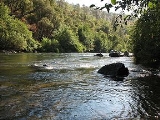
The Mokelumne River is a river
in Northern California
. The Upper Mokelumne River originates in the Sierra Nevada mountain range and flows into Pardee Reservoir and then Camanche
Reservoir in the Sierra foothills
. The Lower Mokelumne River refers to the portion of the river below Camanche Dam
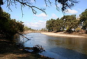
. It crosses California
's Central Valley
, flowing westward through Lodi, California
, and ultimately meeting its confluence
with the San Joaquin River
in the Sacramento-San Joaquin River Delta. The river crosses or forms the border of five California counties: Alpine
, Amador
, Calaveras
, San Joaquin
, and Sacramento
.
The name is Plains Miwok and is constructed from moke, meaning fishnet
, and -umne, a suffix meaning "people of". The town of Mokelumne Hill
was named for the river in about 1850.
run, a scenic, 3 mile Class IV run. The Ponderosa run goes from Ponderosa Way to Electra Powerhouse. The westernmost run is Electra-Middle Bar, a 5+-mile Class II-III run. It begins just below the Electra Powerhouse and ends at the Middle Bar Bridge.
The Mokelumne is also a popular site for fishing, camping, water play, birding, picnics, gold panning, spring wildflower watching, and other activities. Electra Road, just east of Highway 49, is a popular place to run, walk, and enjoy the river. The large granite domes, Calaveras Dome
and Hammer Dome, near Salt Springs Reservoir, are popular for technical rock climbing. Three campgrounds are also located near Salt Springs: Mokelumne River, White Azalea, and Moore Creek.
Above Salt Springs Reservoir, the Mokelumne Wilderness challenges those who seek a true wilderness experience. Backpacking in this federally designated wilderness area requires good back-country skills.
has included an optional expansion of Pardee Reservoir in its http://www.ebmud.com/water_&_environment/water_supply/water_supply_management_program/CEQA/default.htm 2040 water plan. The expansion could drown more than a mile of the river as well as unique cultural and historic sites. Some local governments, conservation, recreation and fishery activists oppose the reservoir expansion.
River
A river is a natural watercourse, usually freshwater, flowing towards an ocean, a lake, a sea, or another river. In a few cases, a river simply flows into the ground or dries up completely before reaching another body of water. Small rivers may also be called by several other names, including...
in Northern California
Northern California
Northern California is the northern portion of the U.S. state of California. The San Francisco Bay Area , and Sacramento as well as its metropolitan area are the main population centers...
. The Upper Mokelumne River originates in the Sierra Nevada mountain range and flows into Pardee Reservoir and then Camanche
Camanche, California
Camanche is a former settlement in Calaveras County, California. It lay at an elevation of 220 feet . Once called Limerick, the town became Camanche in 1849. Gold mining at nearby Cat Camp, Poverty Bar, and Sand Hill brought its population to a peak of 1,500...
Reservoir in the Sierra foothills
Foothills
Foothills are geographically defined as gradual increases in elevation at the base of a mountain range. They are a transition zone between plains and low relief hills to the adjacent topographically high mountains.-Examples:...
. The Lower Mokelumne River refers to the portion of the river below Camanche Dam
Camanche Dam
Camanche Dam is a dam on the Mokelumne River in central California, about east of Lodi. The dam lies in the Sierra Nevada foothills in San Joaquin County and forms Camanche Lake, which serves mainly for flood control. It also has a power station capable of generating 10.7 megawatts....
. It crosses California
California
California is a state located on the West Coast of the United States. It is by far the most populous U.S. state, and the third-largest by land area...
's Central Valley
California Central Valley
California's Central Valley is a large, flat valley that dominates the central portion of California. It is home to California's most productive agricultural efforts. The valley stretches approximately from northwest to southeast inland and parallel to the Pacific Ocean coast. Its northern half is...
, flowing westward through Lodi, California
Lodi, California
Lodi is a city located in , in the northern portion of California's Central Valley. The population was 62,134 at the 2010 census. The California Department of Finance's population estimate as of January 1, 2011 is 62,473....
, and ultimately meeting its confluence
Confluence (geography)
In geography, a confluence is the meeting of two or more bodies of water. It usually refers to the point where two streams flow together, merging into a single stream...
with the San Joaquin River
San Joaquin River
The San Joaquin River is the largest river of Central California in the United States. At over long, the river starts in the high Sierra Nevada, and flows through a rich agricultural region known as the San Joaquin Valley before reaching Suisun Bay, San Francisco Bay, and the Pacific Ocean...
in the Sacramento-San Joaquin River Delta. The river crosses or forms the border of five California counties: Alpine
Alpine County, California
Alpine County is the smallest county, by population, in the U.S. state of California. As of 2010, it had a population of 1,175, all rural. There are no incorporated cities in the county. The county seat is Markleeville...
, Amador
Amador County, California
Amador County is a county located in the Sierra Nevada of the U.S. state of California. As of the 2010 census, the population was 38,091. The county seat is Jackson.Amador County bills itself as "The Heart of the Mother Lode" and lies within the Gold Country...
, Calaveras
Calaveras County, California
Calaveras County is a county located in the Gold Country of the U.S. state of California. Calaveras is the Spanish word for skulls; the county was reportedly named for the remains of Native Americans discovered by the Spanish explorer Captain Gabriel Moraga. As of the 2010 census, the county had a...
, San Joaquin
San Joaquin County, California
San Joaquin County is a county located in Central Valley of the U.S. state of California, just east of the San Francisco Bay Area. As of the 2010 census, the population was 685,306. The county seat is Stockton.-History:...
, and Sacramento
Sacramento County, California
Sacramento County is a county in the U.S. state of California. Its county seat is Sacramento, which is also the state capital. As of 2010 the county had a population of 1,418,788....
.
The name is Plains Miwok and is constructed from moke, meaning fishnet
Fishing net
A fishing net or fishnet is a net that is used for fishing. Fishing nets are meshes usually formed by knotting a relatively thin thread. Modern nets are usually made of artificial polyamides like nylon, although nets of organic polyamides such as wool or silk thread were common until recently and...
, and -umne, a suffix meaning "people of". The town of Mokelumne Hill
Mokelumne Hill, California
Mokelumne Hill is a census-designated place in Calaveras County, California, United States. The population was 646 at the 2010 census, down from 774 at the 2000 census. It is commonly referred to as "Moke Hill" by locals...
was named for the river in about 1850.
Recreational uses
The Mokelumne River is home to five notable Whitewater Kayak runs: Fantasy Falls, Devil's Nose, Tiger Creek Dam, Ponderosa and Electra-Middle Bar. Fantasy Falls, a Class V+, 26-mile wilderness reach, runs from below Highway 4 in Alpine County to the backwaters of Salt Springs Reservoir. Devil's Nose, Class IV-V, runs 17 miles from Salt Springs Dams to Tiger Creek Powerhouse. Below Tiger Creek Dam is the Tiger Creek Dam WhitewaterWhitewater
Whitewater is formed in a rapid, when a river's gradient increases enough to disturb its laminar flow and create turbulence, i.e. form a bubbly, or aerated and unstable current; the frothy water appears white...
run, a scenic, 3 mile Class IV run. The Ponderosa run goes from Ponderosa Way to Electra Powerhouse. The westernmost run is Electra-Middle Bar, a 5+-mile Class II-III run. It begins just below the Electra Powerhouse and ends at the Middle Bar Bridge.
The Mokelumne is also a popular site for fishing, camping, water play, birding, picnics, gold panning, spring wildflower watching, and other activities. Electra Road, just east of Highway 49, is a popular place to run, walk, and enjoy the river. The large granite domes, Calaveras Dome
Calaveras Dome
Calaveras Dome is a Granite dome in Northern California best known as a rock climbing venue. Climbing was active from the 1950s on with a revival during the 70's and 80's. Several dedicated climbers actively developed new routes. Jay Smith, Jeff Altenburg, Paul Crawford, Bob Pinkney, and several...
and Hammer Dome, near Salt Springs Reservoir, are popular for technical rock climbing. Three campgrounds are also located near Salt Springs: Mokelumne River, White Azalea, and Moore Creek.
Above Salt Springs Reservoir, the Mokelumne Wilderness challenges those who seek a true wilderness experience. Backpacking in this federally designated wilderness area requires good back-country skills.
Threats
The East Bay Municipal Utility DistrictEast Bay Municipal Utility District
East Bay Municipal Utility District , colloquially referred to as "East Bay Mud", provides water and sewage treatment for customers in portions of Alameda County and Contra Costa County in California, on the eastern side of San Francisco Bay, including the cities of Richmond, El Cerrito, Hercules,...
has included an optional expansion of Pardee Reservoir in its http://www.ebmud.com/water_&_environment/water_supply/water_supply_management_program/CEQA/default.htm 2040 water plan. The expansion could drown more than a mile of the river as well as unique cultural and historic sites. Some local governments, conservation, recreation and fishery activists oppose the reservoir expansion.
Tributaries
- Dry CreekDry Creek (Mokelumne River)Dry Creek is a stream in northern California which runs from the Sierra Nevada to the Mokelumne River west of Galt.- Tributaries :*North Fork Dry Creek*South Fork Dry Creek*Sutter Creek*Jackson Creek...
- Cosumnes RiverCosumnes RiverThe Cosumnes River is a river in northern California in the United States. It rises on the western slope of the Sierra Nevada and flows approximately into the Central Valley, emptying into the Mokelumne River in the Sacramento-San Joaquin Delta.-Name:...
- Bear RiverBear River (Mokelumne River tributary)The Bear River is a river in the Sierra Nevada in California. It is a tributary of the Mokelumne River. The river and its watershed are entirely in El Dorado National Forest. The river begins as two forks several miles south of Kirkwood. The forks travel roughly southwest and merge just before the...
- Blue Creek
- Beaver Creek
- Green Creek
- Camp Creek
- Ashland Creek
See also
- Mokelumne River AVAMokelumne River AVAThe Mokelumne River AVA is an American Viticultural Area located in San Joaquin County, California. It is located in the southwest part of the larger Lodi AVA, and includes the city of Lodi and the towns of Woodbridge and Acampo...
- Foothill ConservancyFoothill ConservancyOn July 21, 2000, Foothill Conservancy, a nonprofit organization based in Amador County, California, was among the parties signing the historic settlement agreement with PG&E that formed the basis for a new 30-year operating license for the Mokelumne River Project...
- East Bay Municipal Utility DistrictEast Bay Municipal Utility DistrictEast Bay Municipal Utility District , colloquially referred to as "East Bay Mud", provides water and sewage treatment for customers in portions of Alameda County and Contra Costa County in California, on the eastern side of San Francisco Bay, including the cities of Richmond, El Cerrito, Hercules,...
(EBMUD) - Pardee DamPardee DamPardee Dam is a -high structure across the Mokelumne River which marks the boundary between Amador and Calaveras Counties, in the foothills of the Sierra Nevada approximately about northeast of Stockton....
, Pardee Reservoir - Camanche DamCamanche DamCamanche Dam is a dam on the Mokelumne River in central California, about east of Lodi. The dam lies in the Sierra Nevada foothills in San Joaquin County and forms Camanche Lake, which serves mainly for flood control. It also has a power station capable of generating 10.7 megawatts....
, Camanche Reservoir, Mokelumne River Fish Hatchery
External links
- Lodi News-Sentinel: Searching for the Mokelumne Part II
- EPA: Lower Mokelumne watershed
- EBMUD's Mokelumne history
- Fantasy Falls kayaking video
- Amador Ledger-Dispatch: Mokelumne Frustrations Flow Toward EBMUD
- Indymedia: Chris Shutes of CSPA Slams Pardee Reservoir Expansion Project
- East Bay Express: Sierra Water Grab
- Mokelumne River Wild and Scenic video by Mikey Wier
- East Bay MUD 2040 Water Program