

Rapid Creek (South Dakota)
Encyclopedia
Cheyenne River
The Cheyenne River is a tributary of the Missouri River in the U.S. states of Wyoming and South Dakota. It is approximately 295 mi long and drains an area of...
, approximately 86 mi (138 km) long, in South Dakota
South Dakota
South Dakota is a state located in the Midwestern region of the United States. It is named after the Lakota and Dakota Sioux American Indian tribes. Once a part of Dakota Territory, South Dakota became a state on November 2, 1889. The state has an area of and an estimated population of just over...
in the United States
United States
The United States of America is a federal constitutional republic comprising fifty states and a federal district...
.
It rises in southwestern South Dakota, in the Black Hills National Forest
Black Hills National Forest
Black Hills National Forest is located in southwestern South Dakota and northeastern Wyoming. The forest has an area of over 1.25 million acres and is managed by the Forest Service. Forest headquarters are located in Custer, South Dakota...
in the Black Hills
Black Hills
The Black Hills are a small, isolated mountain range rising from the Great Plains of North America in western South Dakota and extending into Wyoming, USA. Set off from the main body of the Rocky Mountains, the region is something of a geological anomaly—accurately described as an "island of...
in Pennington County
Pennington County, South Dakota
As of the census of 2000, there were 88,565 people, 34,641 households, and 23,278 families residing in the county. The population density was 32 people per square mile . There were 37,249 housing units at an average density of 13 per square mile...
. It flows east, is joined by Castle Creek
Castle Creek (South Dakota)
Castle Creek is a tributary of Rapid Creek, approximately 14 mi long, in western South Dakota in the United States.It rises out of Deerfield Reservoir, in the Black Hills in Pennington County approximately 15 mi NNW of Custer. It flows north and east, joining Rapid Creek approximately 4 mi west...
, past Silver City
Silver City, South Dakota
Silver City is an unincorporated community in Pennington County, South Dakota, United States, outside of Rapid City. It lies at the head of Pactola Lake on Rapid Creek, and is about 5 miles west of U.S. Route 385 via a paved county road. The area was first referenced by General George A. Custer...
and through the Pactola Reservoir
Pactola Lake
Pactola Lake is the largest reservoir in the Black Hills of South Dakota and is created by the Pactola Dam. At the bottom of Pactola Lake is the submerged town of Pactola, an old mining camp and site of several military bivouacs during the original settlement of the Black Hills in the...
. Emerging from the Black Hills, it flows through Rapid City
Rapid City, South Dakota
Rapid City is the second-largest city in the U.S. state of South Dakota, and the county seat of Pennington County. Named after Rapid Creek on which the city is established, it is set against the eastern slope of the Black Hills mountain range. The population was 67,956 as of the 2010 Census. Rapid...
, past Farmingdale, and joins the Cheyenne approximately 13 mi (21 km) southwest of Wasta
Wasta, South Dakota
Wasta is a town in Pennington County, South Dakota, United States. The population was 80 at the 2010 census.-Geography:Wasta is located at ....
.
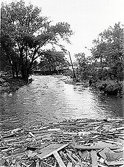
The Rapid Creek is most noted for the Black Hills flood of 1972
Black Hills flood
The Black Hills Flood of 1972, in the Black Hills of Western South Dakota, USA, occurred on June 9, 1972. The extreme rainfall of around of rain in 6 hours sent Rapid Creek and other creeks overflowing and flooded many residential and commercial properties around the Black Hills...
, in which 238 people perished in Rapid City and the Black Hills
Black Hills
The Black Hills are a small, isolated mountain range rising from the Great Plains of North America in western South Dakota and extending into Wyoming, USA. Set off from the main body of the Rocky Mountains, the region is something of a geological anomaly—accurately described as an "island of...
. Since the flood, a flood plain has been established throughout the city making development along the banks inconsiderable.