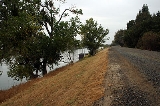
All Topics  
Levee

 
Levee

   Email Print
   Bookmark   Link


Levee


A levee, levée, dike (or dyke), embankment, floodbank or stopbank is a natural or artificial slope or wall to regulate water levels. It is usually earthen
Soil

Soil is the naturally occurring, unconsolidated or loose covering on the Earth's surface. Soil is composed of particles of broken rock that have been altered by chemical and environmental processes including weathering and erosion....
 and often parallel
Parallel (geometry)

Parallelism is a term in geometry and in everyday life that refers to a property in Euclidean space of two or more line s or plane , or a combination of these....
 to the course of a river
River

A river is a natural stream of water, usually freshwater, flowing toward an ocean, a lake, or another stream. In some cases a river flows into the ground or dries up completely before reaching another body of water....
 or the coast.

word levee, from the French word levée (from the feminine past participle of the French verb lever, "to raise"), is used in American English
American English

PhonologyIn many ways, compared to English language in England, North American English is conservative in its phonology. Some distinctive accents can be found on the East Coast of the United States , partly because these areas were in contact with England, and imitated prestigious varieties of English English at a time when those varieties we...
 (notably in the Midwest and Deep South
Deep South

The Deep South is a descriptive category of cultural and geographic subregions in the Southern United States. Historically, it is differentiated from the "Upper South" as being the states which were most dependent on plantation type agriculture during the antebellum period....
); it came into English use in New Orleans circa 1720.

modern word dike is most probably derived from the Dutch
Dutch language

Dutch is a West Germanic languages spoken by over 22 million people as a first language, and about 5 million people as a second language."1% of the EU population claims to speak Dutch well enough in order to have a conversation." Outside the European Union the number of second language speakers of Dutch is very small. Most native...
 word "dijk", where the construction of dikes is well attested since the 12th century.


Discussion
Ask a question about 'Levee'
Start a new discussion about 'Levee'
Answer questions from other users
Full Discussion Forum


Encyclopedia


A levee, levée, dike (or dyke), embankment, floodbank or stopbank is a natural or artificial slope or wall to regulate water levels. It is usually earthen
Soil

Soil is the naturally occurring, unconsolidated or loose covering on the Earth's surface. Soil is composed of particles of broken rock that have been altered by chemical and environmental processes including weathering and erosion....
 and often parallel
Parallel (geometry)

Parallelism is a term in geometry and in everyday life that refers to a property in Euclidean space of two or more line s or plane , or a combination of these....
 to the course of a river
River

A river is a natural stream of water, usually freshwater, flowing toward an ocean, a lake, or another stream. In some cases a river flows into the ground or dries up completely before reaching another body of water....
 or the coast.

Origin of the name


Levee

The word levee, from the French word levée (from the feminine past participle of the French verb lever, "to raise"), is used in American English
American English

PhonologyIn many ways, compared to English language in England, North American English is conservative in its phonology. Some distinctive accents can be found on the East Coast of the United States , partly because these areas were in contact with England, and imitated prestigious varieties of English English at a time when those varieties we...
 (notably in the Midwest and Deep South
Deep South

The Deep South is a descriptive category of cultural and geographic subregions in the Southern United States. Historically, it is differentiated from the "Upper South" as being the states which were most dependent on plantation type agriculture during the antebellum period....
); it came into English use in New Orleans circa 1720.

Dike

The modern word dike is most probably derived from the Dutch
Dutch language

Dutch is a West Germanic languages spoken by over 22 million people as a first language, and about 5 million people as a second language."1% of the EU population claims to speak Dutch well enough in order to have a conversation." Outside the European Union the number of second language speakers of Dutch is very small. Most native...
 word "dijk", where the construction of dikes is well attested since the 12th century. The 126 km long Westfriese Omringdijk
Westfriese Omringdijk

The Westfriese Omringdijk is a dyke system that protected the region of Westflinge, part of the historical region of West Friesland . Westflinge is now commonly referred to as West Friesland as the rest of historical West Friesland assimilated with Holland....
, for instance, was completed by 1250, and was formed by connecting existing older dikes. The Roman chronicler Tacitus
Tacitus

Publius Cornelius Tacitus was a Roman Senate and a historian of the Roman Empire. The surviving portions of his two major works—the Annals and the Histories —examine the reigns of the Roman Emperors Tiberius, Claudius, Nero and those that reigned in the Year of the Four Emperors....
 however mentions the fact that the rebellious Batavi pierced dikes to flood their land and to protect their retreat (AD 70). The Dutch word dijk meant originally both the trench or the bank. The word is closely related to the English verb to dig (EWN).

In Anglo-Saxon
Old English language

Old English is an early form of the English language that was spoken and written in parts of what are now England and south-eastern Scotland between the mid-5th century and the mid-12th century....
, the word dic already existed and was pronounced with a hard c in northern England and as ditch in the south. Similar to Dutch, the English origins of the word lie in digging a trench and forming the upcast soil into a bank alongside it. This practice has meant that the name may be given to either the excavation or the bank. Thus Offa's Dyke
Offa's Dyke

Offa's Dyke is a massive linear Earthworks , roughly following some of Wales-England border between England and Wales. In places, it is up to 65 feet wide and 8 feet high....
 is a combined structure and Car Dyke
Car Dyke

The Car Dyke was, and to large extent still is, an eighty-five mile long ditch which runs along the western edge of the Fens in eastern England....
 is a trench though it once had raised banks as well. In the midlands and north of England, and in the United States, a dike is what a ditch
Ditch

A ditch is usually defined as a small to moderate depression created to channel water.In Old English language, the word dic already existed and was pronounced with a hard c in northern England and as ditch in the south....
 is in the south, a property boundary marker or small drainage channel. Where it carries a stream, it may be called a running dike as in Rippingale Running Dike, which leads water from the catchwater drain
Catchwater drain

A Catchwater Drain is a land drain, a ditch cut across the fall of the land, typically just above the level of low-lying, level ground such as The Fens of eastern England, where some land, tens of kilometres from the sea is at about sea level....
, Car Dyke, to the South Forty Foot Drain in Lincolnshire
Lincolnshire

Lincolnshire is a Counties of England in the east of England. It borders Norfolk, Cambridgeshire, Rutland, Leicestershire, Nottinghamshire, South Yorkshire, and the East Riding of Yorkshire....
 (TF1427). The Weir Dike is a soak dike
Soak dike

The term Soak dike is used in The Fens of eastern England to mean a ditch or drain running parallel with an embankment, for the purpose of taking any water that soaks through from the river or drain beyond the bank....
 in Bourne North Fen
Bourne, Lincolnshire

Bourne is a market town and civil parish on the western edge of the The Fens, in the South Kesteven in southern Lincolnshire, England. The town owes its origin to the Roman road upon which it was built, and also to the exceptionally fine-quality water supply derived locally from natural springs....
, near Twenty
Twenty, Lincolnshire

Twenty is a small, somewhat remote Hamlet , 4 miles east of the market town of Bourne, Lincolnshire, in Lincolnshire, England. Agriculture is the major industry....
 and alongside the River Glen, Lincolnshire.

Artificial levees


The main purpose of an artificial levee is to prevent flooding of the adjoining countryside; however, they also confine the flow of the river, resulting in higher and faster water
Water

Water is a common chemical substance that is essential for the survival of all known forms of life. In typical usage, water refers only to its liquid form or States of matter, but the substance also has a solid state, ice, and a gaseous state, water vapor or steam....
 flow. Levees can be mainly found along the sea, where dunes are not strong enough, along rivers for protection against high-floods, along lakes or along polders. Furthermore, levees have been built for the purpose of empoldering
Polder

A polder is a low-lying tract of land enclosed by embankments known as dike , that forms an artificial hydrology entity, meaning it has no connection with outside water other than through manually-operated devices....
, or as a boundary for an inundation area. The latter can be a controlled inundation by the military or a measure to prevent inundation of a larger area surrounded by levees. Levees have also been built as field boundaries and as military defences
Fortification

Fortifications are military constructions and buildings designed for defense in warfare and military bases. Humans have constructed defensive works for many thousands of years, in a variety of increasingly complex designs....
. More on this type of levee can be found in the article on dry-stone walls.

Levees can be permanent earthworks
Earthworks (engineering)

Earthworks are engineering works created through the moving of massive quantities of soil or unformed rock . Engineers need to concern themselves with issues of geotechnical engineering and with quantity estimation to ensure that soil volumes in the Cut match those of the Fill dirt, while minimizing the distance of movement....
 or emergency constructions (often of sandbag
Sandbag

A sandbag is a sack made of jute, polypropylene or other materials that is filled with sand or soil and used for such purposes as flood, military fortification, shielding glass windows in war zones and ballast....
s) built hastily in a flood emergency. When such an emergency bank is added on top of an existing levee it is known as a cradge.

Levees were first constructed in the Indus Valley Civilization
Indus Valley Civilization

The Indus Valley Civilization , abbreviated IVC, was an ancient civilization that flourished in the Indus River basin. Primarily centered along the Indus river, the civilization encompassed most of Pakistan, including its Sindh, Punjab and Balochistan provinces, and extending into modern day Indian states of Gujarat, Haryana, Punjab...
 (in Pakistan
Pakistan

Pakistan , officially the Islamic Republic of Pakistan, is a country located in South Asia and borders Central Asia and the Middle East. It has a 1,046 kilometre coastline along the Arabian Sea and Gulf of Oman in the south, and is bordered by Afghanistan and Iran in the west, India in the east and People's Republic of China in th...
 and North India
North India

Northern India is a loosely defined region in the northern part of India. The exact meaning of the term varies by usage. The dominant geographical features of northern India are the Indo-Gangetic Plain and the Himalayas, which demarcate the region from Tibet and Central Asia....
 from circa 2600 BC) on which the agrarian life of the Harappan
Harappan

Harappan can refer to:* Aspects related to Harappa an archaeological site and city in northeast Pakistan* The Indus Valley Civilization that thrived along Indus River ...
 peoples depended. Also levees were constructed over 3,000 years ago in ancient Egypt
Ancient Egypt

Ancient Egypt was an Ancient history civilization in eastern North Africa, concentrated along the lower reaches of the Nile in what is now the modern nation of Egypt....
, where a system of levees was built along the left bank of the River Nile for more than 600 miles (966 km), stretching from modern Aswan
Aswan

Aswan , Egyptian language: Swenet , Coptic language: Swan; Greek language: Syene; ) is a city in the south of Egypt, the capital of the Aswan Governorate....
 to the Nile Delta
Nile Delta

The Nile Delta is the River delta formed in Northern Egypt where the Nile River spreads out and drains into the Mediterranean Sea. It is one of the world's largest river deltas?from Alexandria in the west to Port Said in the east, it covers some 240 km of Mediterranean coastline?and is a rich agricultural region....
 on the shores of the Mediterranean. The Mesopotamia
Mesopotamia

Mesopotamia is the area of the Tigris-Euphrates river system, along the Tigris and Euphrates rivers, largely corresponding to modern Iraq, as well as some parts of northeastern Syria, some parts of southeastern Turkey, and some parts of the Khuzestan Province of southwestern Iran....
n civilizations and ancient China also built large levee systems. Because a levee is only as strong as its weakest point, the height and standards of construction have to be consistent along its length. Some authorities have argued that this requires a strong governing authority to guide the work, and may have been a catalyst for the development of systems of governance in early civilizations. However others point to evidence of large scale water-control earthen works such as canals and/or levees dating from before King Scorpion
King Scorpion

Scorpion, also King Scorpion or Scorpion II refers to the second of two kings so-named of Upper Egypt during the Protodynastic Period of Egypt....
 in Predynastic Egypt
Predynastic Egypt

The Predynastic Period of Egypt is traditionally the period between the Early Neolithic and the beginning of the Pharaonic monarchy beginning with King Narmer....
 during which governance was far less centralized.

Levees are usually built by piling earth on a cleared, level surface. Broad at the base, they taper to a level top, where temporary embankments or sandbag
Sandbag

A sandbag is a sack made of jute, polypropylene or other materials that is filled with sand or soil and used for such purposes as flood, military fortification, shielding glass windows in war zones and ballast....
s can be placed. Because flood discharge intensity increases in levees on both river banks, and because silt
Silt

Silt is soil or Rock derived granular material of a Particle size between sand and clay. Silt may occur as a soil or as suspended sediment in a surface water body....
 deposits raise the level of riverbed
Riverbed

Riverbed may refer to:*Stream bed, the channel bottom of a stream or river or creek*Wadi, a dry riverbed that contains water only during times of heavy rain...
s, planning and auxiliary measures are vital. Sections are often set back from the river to form a wider channel, and flood valley basins are divided by multiple levees to prevent a single breach from flooding a large area. A levee made from stones laid in horizontal rows with a bed of thin turf between each of them is known as a spetchel.

Artificial levees require substantial engineering. Their surface must be protected from erosion, so they are planted with vegetation such as Bermuda grass in order to bind the earth together. On the land side of high levees, a low terrace of earth known as a banquette is usually added as another anti-erosion measure. On the river side, erosion from strong waves or currents presents an even greater threat to the integrity of the levee. The effects of erosion are countered by planting with willow
Willow

Willows, sallows, and osiers form the genus Salix, around 400 species of deciduous trees and shrubs, found primarily on moist soils in cold and temperate regions of the Northern Hemisphere....
s, weighted matting or concrete revetment
Revetment

Revetments, or rev?tements , have a variety of meanings in architecture, engineering and art history. In river engineering or coastal defence, they are sloping structures placed on banks or cliffs in such a way as to absorb the energy of incoming water....
s. Separate ditches or drainage tiles are constructed to ensure that the foundation does not become waterlogged.

River flood prevention

Gretnalevee
Prominent levee systems exist along the Mississippi River
Mississippi River

The Mississippi River is the longest river in the United States, with a length of from its source in Lake Itasca in Minnesota to its mouth in the Gulf of Mexico....
 and Sacramento River
Sacramento River

The Sacramento River is the longest river entirely within the United States state of California. Starting at the confluence of the South Fork and Middle Fork Sacramento River, near Mount Shasta in the Cascade Range, the Sacramento flows south for , through the northern California Central Valley, between the Pacific Coast Range and the Sierr...
 in the United States
United States

The United States of America is a Federal government constitutional republic comprising U.S. state and a federal district. The country is situated mostly in central North America, where its Contiguous United States and Washington, D.C., the Capital districts and territories, lie between the Pacific Ocean and Atlantic Oceans, Borders of the U...
, and the Po
Po River

The Po is a river that flows 652 km eastward across northern Italy, from Monviso to the Adriatic Sea near Venice. It has a drainage area of 71,000 km? and is the longest river in Italy....
, Rhine
Rhine

File:Swiss Grand Canyon.jpgThe Rhine is one of the longest and most important rivers in Europe, at , with an average discharge of more than ....
, Meuse River
Meuse River

File:01-Namur-290305 JPG.jpgThe Meuse , is a major European river, rising in France and flowing through Belgium and the Netherlands before draining into the North Sea....
, Loire
Loire

Loire is an departments of France in the east-central part of France occupying the River Loire's upper reaches....
, Vistula
Vistula

The Vistula , is the longest river in Poland at 1,047 km in length. It drains an area of 194,424 km? , of which 168,699 km? lies within Poland ....
, the river delta in the Netherlands and Danube
Danube

The Danube is the longest river in the European Union and Europe's second longest river after the Volga.The river originates in the Black Forest in Germany as the much smaller Brigach and Breg River rivers which join at the eponymously named German town Donaueschingen, after which it is known as the Danube and flows eastwards for a distance...
 in Europe
Europe

Europe is, conventionally, one of the world's seven continents. Comprising the westernmost peninsula of Eurasia, Europe is generally divided from Asia to its east by the water divide of the Ural Mountains, the Ural , the Caspian Sea, and by the Caucasus Mountains to the southeast....
.

The Mississippi River levee system represents one of the largest such systems found anywhere in the world. They comprise over 3,500 miles (5,600 km) of levees extending some 1,000 miles (1,600 km) along the Mississippi, stretching from Cape Girardeau, Missouri
Cape Girardeau, Missouri

Cape Girardeau is a city located in Cape Girardeau County, Missouri and Scott County, Missouri counties in Southeast Missouri in the United States....
 to the Mississippi Delta
Mississippi Delta

The Mississippi Delta is the distinct northwest section of the state of Mississippi that lies between the Mississippi River and Yazoo Rivers. Technically not a River delta but part of an alluvial plain, it has been said that the Delta "begins in the lobby of the Peabody Hotel and ends on Catfish Row in Vicksburg, Mississippi" ...
. They were begun by French settlers in Louisiana
Louisiana

The State of Louisiana is a U.S. state located in the U.S. Southern States of the United States of America. Its capital is Baton Rouge and largest city is New Orleans....
 in the 18th century to protect the city of New Orleans. The first Louisianan levees were about 3 feet (0.9 m) high and covered a distance of about 50 miles (80 km) along the riverside. By the mid-1980s, they had reached their present extent and averaged 24 feet (7 m) in height; some Mississippi levees are as much as 50 feet (15 m) high. The Mississippi levees also include some of the longest continuous individual levees in the world. One such levee extends southwards from Pine Bluff, Arkansas
Pine Bluff, Arkansas

Pine Bluff is the largest city and county seat of Jefferson County, Arkansas, Arkansas, United States. It is also the principal city of the Pine Bluff Metropolitan Statistical Area and part of the Little Rock, Arkansas-North Little Rock, Arkansas-Pine Bluff, Arkansas Combined Statistical Area....
 for a distance of some 380 miles (611 km).

Coastal flood prevention


Levees are very common on the flatlands bordering the Bay of Fundy
Bay of Fundy

The Bay of Fundy is a Headlands and bays on the Atlantic Ocean coast of North America, on the northeast end of the Gulf of Maine between the Canada Provinces of Canada of New Brunswick and Nova Scotia, with a small portion touching the United States U.S....
 in New Brunswick
New Brunswick

New Brunswick is one of Canada's three Maritime provinces and is the only Constitution of Canada bilingual province in the federation. The provincial capital is Fredericton....
 and Nova Scotia
Nova Scotia

Nova Scotia is a Canadian Provinces and territories of Canada located on Canada's southeastern coast. It is the most populous province in Atlantic Canada....
 Canada
Canada

Canada is a country occupying most of northern North America, extending from the Atlantic Ocean in the east to the Pacific Ocean in the west and northward into the Arctic Ocean....
. The Acadians who settled the area can be credited with construction of most of the levees in the area, created for the purpose of farming the fertile tidal flatlands. These levees are referred to as "aboiteau". In the Lower Mainland
Lower Mainland

The Lower Mainland is a name commonly applied to the region surrounding Vancouver, British Columbia, Canada. In 2007, 2,524,113 people live in the region; sixteen of the province's thirty most populous municipalities are located there....
 around the city of Vancouver
Vancouver

Vancouver is a coastal city and major seaport located in the Lower Mainland of southwestern British Columbia, Canada. It is the largest city in British Columbia and the second largest metropolitan area in the Pacific Northwest region....
, British Columbia
British Columbia

British Columbia is the westernmost of Canada's Provinces and territories of Canada and is famed for its natural beauty, as reflected in its Latin motto, Splendor sine occasu ....
, there are levees to protect low-lying land in the Fraser River
Fraser River

The Fraser River is the longest river in British Columbia, Canada, rising near Mount Robson in the Rocky Mountains and flowing for 1,375 km , into the Pacific Ocean at the city of Vancouver, British Columbia....
 delta, particularly the city of Richmond
Richmond, British Columbia

Richmond is a coastal city, incorporated in the Canadian province of British Columbia. Part of Metro Vancouver, its neighbouring communities are Vancouver and Burnaby, British Columbia to the north, New Westminster, British Columbia to the east, and Delta, British Columbia to the south, while the Strait of Georgia forms its western border...
 on Lulu Island
Lulu Island

Lulu Island is the geographic name of the island making up most of the Richmond, British Columbia, a major suburb of Vancouver, British Columbia....
. There are also levees to protect other locations which have flooded in the past, such as land adjacent to the Pitt River
Pitt River

The Pitt River in British Columbia, Canada is a large tributary of the Fraser River, entering it a few miles upstream from New Westminster, British Columbia and about 25km ESE of Downtown Vancouver, British Columbia....
 and other tributary rivers.

Natural levees

Levees are commonly thought of as man-made, but they can also be natural. The ability of a river to carry sediments varies very strongly with its speed. When a river floods over its banks, the water spreads out, slows down, and deposits its load of sediment. Over time, the river's banks are built up above the level of the rest of the floodplain
Floodplain

||-||-||-||-||-||-||-||}A floodplain, or flood plain, is flat or nearly flat land adjacent to a stream or river that experiences occasional or periodic flooding....
. The resulting ridges are called natural levees.

When the river is not in flood state it may deposit material within its channel, raising its level. The combination can raise not just the surface, but even the bottom of the river above the surrounding country. Natural levees are especially noted on the Yellow River in China
China

China is a Culture of China, an ancient civilization, and, depending on perspective, a national or multinational entity extending over a large area in East Asia....
 near the sea where oceangoing ships appear to sail high above the plain on the elevated river. Natural levees are a common feature of all meandering rivers in the world.

Levees in tidal waters

The basic process occurs in tidal creeks when the incoming tide carries mineral material of all grades up to the limit imposed by the energy of the flow. As the tide overflows the sides of the creek towards high water, the flow rate at the brink slows and larger sediment is deposited, forming the levee. At the height of the tide, the water stands on the salt-marsh or flats and the finer particles slowly settle, forming clay. In the early ebb, the water level in the creek falls leaving the broad expanse of water standing on the marsh at a higher level.

The area of water on the marsh is much greater than the water surface of the creek so that in the latter, the flow rate is much greater. It is this rush of water, perhaps an hour after high water, which keeps the creek channel open. The cross-sectional area of the water body in the creek is small compared with that initially over the levee which at this stage is acting as a weir. The deposited sediment (coarse on the levee and on the mud flats or salt-marsh) therefore tends to stay put so that, tide by tide, the marsh and levee grow higher until they are of such a height that few tides overflow them. In an active system, the levee is always higher than the marsh. That is how it came to be called "une rive levée", or raised shore.

Levee failures and breaches


Man-made levees can fail in a number of ways. The most frequent (and dangerous) form of levee failure is a breach. A levee breach is when part of the levee actually breaks away, leaving a large opening for water to flood the land protected by the levee. A breach can be a sudden or gradual failure that is caused either by surface erosion or by a subsurface failure of the levee. Levee breaches are often accompanied by levee boils, or sand boil
Sand boil

Sand Boils occur when water under pressure wells up through a bed of sand. It looks like it is "boiling" up from the bed of sand hence the name....
s. A sand boil occurs when the upward pressure of water flowing through soil pores under the levee (underseepage) exceeds the downward pressure from the weight of the soil above it. The underseepage resurfaces on the landside, in the form of a volcano-like cone of sand. Boils signal a condition of incipient instability which may lead to erosion of the levee toe or foundation or result in sinking of the levee into the liquefied foundation below. Complete breach of the levee may quickly follow.

Sometimes levees are said to fail when water overtops the crest of the levee. Levee overtopping can be caused when flood waters simply exceed the lowest crest of the levee system or if high winds begin to generate significant swells in the ocean or river water to bring waves crashing over the levee. Overtopping can lead to significant landside erosion of the levee or even be the mechanism for complete breach. Properly built levees are armored or reinforced with rocks or concrete to prevent erosion and failure.

New Orleans


The words levee and levee breach were brought heavily into the public consciousness after the levee failures in metro New Orleans on August 29, 2005 when Hurricane Katrina passed east of the city. Levees breached in over 50 different places submerging 80 percent of the city. Most levees failed due to water overtopping them but some failed when water passed underneath the levee foundations causing the levee wall to shift and resulting in catastrophic sudden breaching. The sudden breaching released highly pressured water that moved houses off their foundations and tossed cars into trees. This happened in the Ninth Ward when the Industrial Canal
Industrial Canal

The Industrial Canal is a 5.5 mile waterway in New Orleans, Louisiana, United States. The waterway's proper name, as used by the U.S. Army Corps of Engineers and on NOAA nautical charts, is Inner Harbor Navigation Canal ....
 breached and also in the Lakeview neighborhood when the 17th Street Canal breached. Effects of breached levees are discussed further in and 2005 levee failures in Greater New Orleans, which cites a death toll of 1,464. In New Orleans, the United States Army Corps of Engineers
United States Army Corps of Engineers

The United States Army Corps of Engineers is a federal agency and a major Army command made up of some 34,600 civilian and 650 military personnel, making it the world's largest public services engineering, design and construction management agency....
 is the Federal agency responsible for levee design and construction as defined in the Flood Control Act of 1965
Flood Control Act of 1965

The Flood Control Act of 1965, Title II of , was enacted on October 27, 1965, by the 89th United States Congress and authorized the United States Army Corps of Engineers to design and construct numerous flood control projects....
 and subject to local participation requirements, some of which were later waived. Fault has been aimed at the Corps of Engineers, their local contractors, and local levee boards.

North Sea


The St. Elizabeth's flood
St. Elizabeth's flood (1421)

The St. Elizabeth's flood of 1421 was a flooding of an area in what is now the Netherlands. It takes its name from the feast day of Saint Elisabeth of Hungary which was formerly November 19....
 of 1421 was caused by a surge of seawater being forced upriver during a storm, overflowing the river dikes and submerging approximately 300 square kilometres of land (over 100 square miles) in The Netherlands. Estimates of people having died range from 2,000 to 10,000. Parts of the submerged lands have still not been reclaimed resulting in the Biesbosch
Biesbosch

De Biesbosch , is one of the largest national parks of the Netherlands and one of the last freshwater tide areas in Europe. The Biesbosch consists of a rather large network of rivers and smaller and larger creeks with islands....
 wetlands.

During the North Sea flood of 1953
North Sea flood of 1953

The North Sea flood of 1953 and the associated storm combined to create a major natural disaster which affected the coastlines of the Netherlands and England on the night of 31 January ? 1 February 1953....
, in the night of 31 January – 1 February 1953, many dikes in the provinces of Zeeland
Zeeland

Zeeland , also called Zealand in English language and Zeelandic, is a province of the Netherlands. The province, located in the south-west of the country, consists of a number of islands and a strip bordering Belgium....
, Zuid-Holland
South Holland

South Holland is a Provinces of the Netherlands situated on the North Sea in the western part of the Netherlands. The provincial capital is The Hague and its largest city is Rotterdam....
 and Noord-Brabant
North Brabant

North Brabant is a Provinces of the Netherlands of the Netherlands, located in the south of the country, bordered by Belgium in the south, the Meuse River in the north, Limburg in the east and Zeeland in the west....
 in the Netherlands
Netherlands

The Netherlands is a country that is part of the Kingdom of the Netherlands. It is a parliamentary democratic constitutional monarchy. The Netherlands is located in North-West Europe, and bordered by the North Sea to the north and west, Belgium to the south, and Germany to the east....
 proved not to be resistant to the combination of spring tide and a northwesterly storm, killing 1,835 people. A further 307 people were killed by dike breaches in the United Kingdom
United Kingdom

The United Kingdom of Great Britain and Northern Ireland, commonly known as the United Kingdom , the UK or Britain,is a sovereign state located off the northwestern coast of continental Europe....
, in the counties of Lincolnshire
Lincolnshire

Lincolnshire is a Counties of England in the east of England. It borders Norfolk, Cambridgeshire, Rutland, Leicestershire, Nottinghamshire, South Yorkshire, and the East Riding of Yorkshire....
, Norfolk
Norfolk

Norfolk is a low-lying Counties of England in the East of England. It has borders with Lincolnshire to the west, Cambridgeshire to the west and southwest and with Suffolk to the south....
, Suffolk
Suffolk

Suffolk is a Non-metropolitan counties of England of Historic counties of England in East Anglia, England. It has borders with Norfolk to the north, Cambridgeshire to the west and Essex to the south....
 and Essex
Essex

Essex is a counties of England in the East of England England. The county town is Chelmsford, and the highest point of the county is Chrishall Common near the village of Langley, Essex, close to the Hertfordshire border, which reaches ....
.

Other breaches

The Great Mississippi Flood of 1927
Great Mississippi Flood of 1927

The Great Mississippi Flood of 1927 was the most destructive river flood in United States history....
 occurred when the Mississippi River
Mississippi River

The Mississippi River is the longest river in the United States, with a length of from its source in Lake Itasca in Minnesota to its mouth in the Gulf of Mexico....
 breached levees and flooded , killing 246 people in seven states and displacing 700,000 people.

On Dec. 24, 1955, at just after midnight, a levee on the west bank of the Feather River
Feather River

The Feather River is a principal tributary of the Sacramento River, in length, in Northern California in the United States. It drains part of the northern Sierra Nevada and a small portion of the middle of the Sacramento Valley....
 collapsed just south of Yuba City, Ca., resulting in the drowning of 38 residents.

On Feb. 20, 1986, a levee on the south bank of the Yuba River
Yuba River

The Yuba River is an important river in California and a major tributary of the Feather River, which is a tributary of the Sacramento River. The river begins as three separate forks, the north, south and middle, in the Sierra Nevada Mountains....
 collapsed at the northern Sacramento Valley
Sacramento Valley

The Sacramento Valley is the portion of the California Central Valley that lies to the north of the Sacramento Delta in the U.S. state of California....
 community of Linda, California
Linda, California

Linda is a census-designated place in Yuba County, California, California, United States. The population was 13,474 at the 2000 census....
 in Yuba County, inundating 36 square miles and destroying 600 homes.

On Jan. 2, 1997, a levee on the west bank of the Feather River
Feather River

The Feather River is a principal tributary of the Sacramento River, in length, in Northern California in the United States. It drains part of the northern Sierra Nevada and a small portion of the middle of the Sacramento Valley....
 collapsed at the northern Sacramento Valley community of Arboga, California
Arboga, California

Arboga is an unincorporated area in Yuba County, California, California. It lies at an elevation of 56 feet . It was named in in 1911 by the pastor of the Swedish Mission Church for his hometown of Arboga....
 in Yuba County, killing three people. More than 100,000 people in Yuba and Sutter counties were evacuated.

On 3 June, 2004, Jones Tract, an inland island that is protected by a series of levees located in the Sacramento-San Joaquin Delta, failed. Though the exact cause of the levee failure is not known, the breach in the levee allowed water from the Middle River to flood the island.

On January 5, 2008, a levee in Fernley, Nevada
Fernley, Nevada

Fernley is a city in Lyon County, Nevada and Washoe County, Nevada counties in the U.S. state of Nevada. The city incorporated in 2001; prior to that it was a census-designated place ....
 burst
Fernley, Nevada

Fernley is a city in Lyon County, Nevada and Washoe County, Nevada counties in the U.S. state of Nevada. The city incorporated in 2001; prior to that it was a census-designated place ....
, flooding portions of the town and forcing the evacuations of 3,500 residents.

On September 14, 2008, a levee in Munster, Indiana
Munster, Indiana

Munster is a town in North Township, Lake County, Indiana, Lake County, Indiana, in northwestern Indiana in the United States. The town lies in the Chicago metropolitan area, colloquially known as Chicago metropolitan area....
 broke on the Little Calumet River resulting in flooding in most of Munster.

History


The inhabitants of the Indus Valley Civilization
Indus Valley Civilization

The Indus Valley Civilization , abbreviated IVC, was an ancient civilization that flourished in the Indus River basin. Primarily centered along the Indus river, the civilization encompassed most of Pakistan, including its Sindh, Punjab and Balochistan provinces, and extending into modern day Indian states of Gujarat, Haryana, Punjab...
 built the first dikes in the world around the 1st millennium BCE. This was the same period when the dockyard at Lothal
Lothal

Lothal is one of the most prominent cities of the ancient Indus Valley Civilization. Located in the modern state of Gujarat and dating from 24th century BC, it is one of India's most important archaeology site that dates from that era....
 was in operation. The use of dykes became known from then onwards.

See also


  • Dam
    Dam

    A dam is a barrier that Reservoirs surface water or underground streams. Dams generally serve the primary purpose of retaining water, while other structures such as floodgates, levees, and Dike are used to manage or prevent water flow into specific land regions....
  • Floodway
  • Subsidence
    Subsidence

    In geology, engineering, and surveying, subsidence is the motion of a surface as it shifts downward relative to a datum such as sea-level. The opposite of subsidence is Tectonic uplift, which results in an increase in elevation....


External links

  • Project of dikes, dams and barriers in the Netherlands