
Red River Flood, 1997
Encyclopedia
The Red River Flood of 1997 was a major flood
that occurred in April and May 1997, along the Red River of the North
in North Dakota
, Minnesota
, and Southern Manitoba
. It was the most severe flood of the river since 1826. The flood reached throughout the Red River Valley
, affecting the cities of Fargo
and Winnipeg, but none so greatly as in Grand Forks
and East Grand Forks
, where floodwaters reached over 3 miles (4.8 km) inland, inundating virtually everything in the twin communities. Total damages for the Red River region were US$
3.5 billion
The flood was the result of abundant snowfall and extreme temperatures.
Flooding in Manitoba resulted in over $
500 million in damages, although the Red River Floodway
, an artificial waterway affectionately known as "Duff's Ditch" saved Winnipeg from flooding. This flood stimulated improvements to the flood protection system.
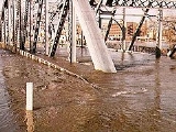
In Grand Forks, although hundreds of people prepared for the flood with sandbag
dikes, based on a 49-foot estimate of flooding set by the National Weather Service
, the river crested at 54 feet in Grand Forks. Grand Forks mayor Pat Owens
had to order the evacuation of over 50,000 people as a large portion of the city was flooded. A large fire started in Grand Forks, engulfing eleven buildings and sixty apartment units before being extinguished.
Those affected by the flood in the U.S. received donations from across the nation, along with billions in federal aid. City officials and flood-forecasters were criticized for the difference in estimates and actual flood levels. Grand Forks and East Grand Forks built new dikes to prevent damages from future floods and began to rebuild around the river, developing a campground recreation area
, park, and shopping districts where homes once stood.
 The Red River in Manitoba and the U.S. States of Minnesota and North Dakota has flooded repeatedly through the centuries, endangering lives and property. The river is highly prone to flooding because of its northward flow. As spring approaches, the snow is melted from south to north alongside the riverflow. There is also the possibility that the surplus water can hit unmelted ice on the river and back up. The flatness of the terrain and small slope of the river is a significant factor.
Floods occurred in both 1948 and 1950. The 1950 flood reached a high of 30 ft (9.2 m) at Winnipeg—causing the largest evacuation in Canada's history of 100,000 people and $606 million CAD (1997) of damage, prompting the government of Manitoba to set up flood safety measures.
The first known records of floods along the Red River appeared in the 1770s. Severe floods occurred throughout the 1800s and 1900s, with one of the most recent major floods occurring in 1979. Homes not damaged in that flood were incorrectly assumed to be safe from a future flood.
and Minnesota
. A few sets of "sister cities" sit directly on this border, with the most devastated by the floodwaters being Grand Forks, North Dakota
and its counterpart East Grand Forks, Minnesota
, although other pairs saw significant flooding and damage as well, including Fargo, North Dakota
/Moorhead, Minnesota
(Fargo-Moorhead
) and Wahpeton, North Dakota
/Breckenridge, Minnesota
. Much of the flooding occurred not only from the rising river, but from overland flooding, as the flooded Red River was unable to drain meltwater away, necessitating dikes on both the riverfront and around the edges of towns.
There was some sense of imminent threat in Grand Forks, but the cities could not prepare for such an enormous flood. The National Weather Service
(NWS) had a long-standing forecast for the river to crest at 49 feet (14.9 m), which was the river's highest level during the 1979 flood. The cities had been able to get their dikes to this level, but the river continued to rise past it, to the astonishment of the NWS (which didn't upgrade its forecast until April 16, the day the river actually reached 49 feet). The dikes in the low-lying Lincoln Drive neighborhood of Grand Forks were the first to break, doing so early on April 18. Other dikes over Grand Forks and East Grand Forks area failed that day and the next, flooding thousands of homes. During this time, Grand Forks mayor Pat Owens ordered the evacuation of over 50,000 people, which up to that time, had been the largest evacuation in the United States since the evacuation of residents in Atlanta, Georgia
during the Civil War
.
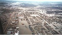 Water reached areas over two miles (3 km) away from the Red River, necessitating the evacuation of all of East Grand Forks and 75% of Grand Forks. School was canceled in both cities for the remainder of the term, as were classes at the University of North Dakota
. Because all transportation was cut off between the two cities (and for many miles, the two states), East Grand Forks residents were evacuated to nearby Crookston
, namely to the University of Minnesota Crookston
, while residents of Grand Forks, who were given mandatory evacuation orders on April 18, went to Grand Forks Air Force Base
(residents stayed in airplane hangars containing more than 3,000 cots). Many residents also evacuated to motels and homes in neighboring communities. The river crested at 54.35 feet (16.6 m) on April 21 and the river level did not fall below 49 feet (14.9 m) until April 26. Because water drained so slowly out of the most low-lying areas, some homeowners couldn't visit their damaged property until May. By May 30, the Red River had receded below flood stages everywhere in North Dakota.
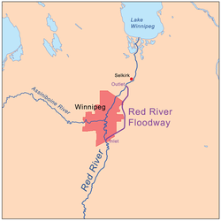 The province of Manitoba completed the Red River Floodway
in 1968 after six years of excavation, put up permanent dikes in eight towns south of Winnipeg, and built clay dikes and diversion dams in the Winnipeg area. Other flood control structures completed later were the Portage Diversion
and the Shellmouth Dam on the Assiniboine
. However, even with these flood protection measures, in 1997 the province experienced a flood of 7.5 m (21.6 ft), which caused 28,000 people to be evacuated and $500 million CAD
in damage to property and infrastructure.
Called "The Flood of the Century", the 1997 flood had a probability of occurrence of about once in 100 years, and came close to overcoming Winnipeg's existing flood protection system. At the time, the Winnipeg Floodway was designed to protect against a flow 60,000 cu. ft. per second, but the 1997 flow was 63,000 cu. ft. per second. To compensate, the province broke operational rules for the floodway, as defined in legislation, during the night of April 30 / May 1, preventing waters in Winnipeg from rising above the designed limit of 24.5' above the "James Avenue datum", but causing additional flooding upriver. The mayor of Winnipeg, announcing what should have been the bad news that the design limit had been reached, misinterpreted this as good news that the flooding had peaked. City sand-bagging stopped, and national reporters left the city, but the water continued to rise inside and outside of the city until the actual peak late on May 3 / early on May 4. The city sometimes claims the peak occurred on May 1, while more scientific reports record a peak on May 3/4.
Towns upriver in Manitoba, forewarned by footage of Grand Forks buildings burning and covered in meters of water, built ring dikes to protect their homes and properties, and the province of Manitoba called in the Canadian Forces
, the Royal Canadian Mounted Police
and the provincial Department of Natural Resources. Many also chose to evacuate, including residents from Morris
who had only two days notice to evacuate to Winnipeg. Thousands of volunteers also helped to build sandbag
dikes around homes and property. An emergency dike, later called the Brunkild Z-dike, 42 km (26.1 mi) long, was constructed in a matter of days at a cost of $10 million (CAD) when it was realized that overland flooding threatened the city of Winnipeg.
Almost all of the ring dikes around the towns held, except for Ste. Agathe
. The town's dike system was prepared for the river approaching from the south, but the river had spread and swamped the town from the west. At the flood's peak in Canada
on May 4, the Red River occupied an area of 1,840 km² (710 mi²) with more than 2,560 km² (990 mi²) of land underwater, which earned it the nickname "Red Sea".
The province of Manitoba asked the International Joint Commission
(IJC) to provide a report on the flood event and to recommend measures to ensure further flood protection for the city of Winnipeg. Largely as a result of this study, the province has been widening the floodway since 2004.
While the flooding was still underway, the federal Liberal
government led by Jean Chrétien
called a snap
election
. Several of the party's MPs from the province, including Reg Alcock
, requested a delay until the flooding was under control. When Chrétien let the election go ahead as originally planned, Alcock transformed his campaign office into a volunteer relief centre, spending his time in relief efforts instead of campaigning, and won re-election.
and American President Bill Clinton
appointed the International Red River Basin Task Force containing members of both countries. The task force's purpose was to find ways to improve flood forecasting.
Flood
A flood is an overflow of an expanse of water that submerges land. The EU Floods directive defines a flood as a temporary covering by water of land not normally covered by water...
that occurred in April and May 1997, along the Red River of the North
Red River of the North
The Red River is a North American river. Originating at the confluence of the Bois de Sioux and Otter Tail rivers in the United States, it flows northward through the Red River Valley and forms the border between the U.S. states of Minnesota and North Dakota before continuing into Manitoba, Canada...
in North Dakota
North Dakota
North Dakota is a state located in the Midwestern region of the United States of America, along the Canadian border. The state is bordered by Canada to the north, Minnesota to the east, South Dakota to the south and Montana to the west. North Dakota is the 19th-largest state by area in the U.S....
, Minnesota
Minnesota
Minnesota is a U.S. state located in the Midwestern United States. The twelfth largest state of the U.S., it is the twenty-first most populous, with 5.3 million residents. Minnesota was carved out of the eastern half of the Minnesota Territory and admitted to the Union as the thirty-second state...
, and Southern Manitoba
Manitoba
Manitoba is a Canadian prairie province with an area of . The province has over 110,000 lakes and has a largely continental climate because of its flat topography. Agriculture, mostly concentrated in the fertile southern and western parts of the province, is vital to the province's economy; other...
. It was the most severe flood of the river since 1826. The flood reached throughout the Red River Valley
Red River Valley
The Red River Valley is a region in central North America that is drained by the Red River of the North. It is significant in the geography of North Dakota, Minnesota, and Manitoba for its relatively fertile lands and the population centers of Fargo, Moorhead, Grand Forks, and Winnipeg...
, affecting the cities of Fargo
Fargo, North Dakota
Fargo is the largest city in the U.S. state of North Dakota and the county seat of Cass County. In 2010, its population was 105,549, and it had an estimated metropolitan population of 208,777...
and Winnipeg, but none so greatly as in Grand Forks
Grand Forks, North Dakota
Grand Forks is the third-largest city in the U.S. state of North Dakota and the county seat of Grand Forks County. According to the 2010 census, the city's population was 52,838, while that of the city and surrounding metropolitan area was 98,461...
and East Grand Forks
East Grand Forks, Minnesota
-K-12:The East Grand Forks School District enrolls over 1,000 students and operates two elementary schools , Central Middle School, and East Grand Forks Senior High School. There are also two private Christian schools. Sacred Heart School is a Roman Catholic elementary, middle, and high school...
, where floodwaters reached over 3 miles (4.8 km) inland, inundating virtually everything in the twin communities. Total damages for the Red River region were US$
United States dollar
The United States dollar , also referred to as the American dollar, is the official currency of the United States of America. It is divided into 100 smaller units called cents or pennies....
3.5 billion
The flood was the result of abundant snowfall and extreme temperatures.
Flooding in Manitoba resulted in over $
Canadian dollar
The Canadian dollar is the currency of Canada. As of 2007, the Canadian dollar is the 7th most traded currency in the world. It is abbreviated with the dollar sign $, or C$ to distinguish it from other dollar-denominated currencies...
500 million in damages, although the Red River Floodway
Red River Floodway
The Red River Floodway is an artificial flood control waterway in Western Canada, first used in 1969. It is a long channel which, during flood periods, takes part of the Red River's flow around the city of Winnipeg, Manitoba to the east and discharges it back into the Red River below the dam at...
, an artificial waterway affectionately known as "Duff's Ditch" saved Winnipeg from flooding. This flood stimulated improvements to the flood protection system.
In Grand Forks, although hundreds of people prepared for the flood with sandbag
Sandbag
A sandbag is a sack made of hessian/burlap, polypropylene or other materials that is filled with sand or soil and used for such purposes as flood control, military fortification, shielding glass windows in war zones and ballast....
dikes, based on a 49-foot estimate of flooding set by the National Weather Service
National Weather Service
The National Weather Service , once known as the Weather Bureau, is one of the six scientific agencies that make up the National Oceanic and Atmospheric Administration of the United States government...
, the river crested at 54 feet in Grand Forks. Grand Forks mayor Pat Owens
Pat Owens
Patrica A. Owens was the mayor of Grand Forks, North Dakota during the flood that devastated the city in April 1997...
had to order the evacuation of over 50,000 people as a large portion of the city was flooded. A large fire started in Grand Forks, engulfing eleven buildings and sixty apartment units before being extinguished.
Those affected by the flood in the U.S. received donations from across the nation, along with billions in federal aid. City officials and flood-forecasters were criticized for the difference in estimates and actual flood levels. Grand Forks and East Grand Forks built new dikes to prevent damages from future floods and began to rebuild around the river, developing a campground recreation area
Red River State Recreation Area
Red River State Recreation Area is part of the Greater Grand Forks Greenway and is located in the city of East Grand Forks, Minnesota on the banks of the Red River of the North and the Red Lake River. The State Recreation Area is owned and managed by the Minnesota Department of Natural...
, park, and shopping districts where homes once stood.
Prior floods
Floods occurred in both 1948 and 1950. The 1950 flood reached a high of 30 ft (9.2 m) at Winnipeg—causing the largest evacuation in Canada's history of 100,000 people and $606 million CAD (1997) of damage, prompting the government of Manitoba to set up flood safety measures.
The first known records of floods along the Red River appeared in the 1770s. Severe floods occurred throughout the 1800s and 1900s, with one of the most recent major floods occurring in 1979. Homes not damaged in that flood were incorrectly assumed to be safe from a future flood.
North Dakota and Minnesota
The Red River forms the border between North DakotaNorth Dakota
North Dakota is a state located in the Midwestern region of the United States of America, along the Canadian border. The state is bordered by Canada to the north, Minnesota to the east, South Dakota to the south and Montana to the west. North Dakota is the 19th-largest state by area in the U.S....
and Minnesota
Minnesota
Minnesota is a U.S. state located in the Midwestern United States. The twelfth largest state of the U.S., it is the twenty-first most populous, with 5.3 million residents. Minnesota was carved out of the eastern half of the Minnesota Territory and admitted to the Union as the thirty-second state...
. A few sets of "sister cities" sit directly on this border, with the most devastated by the floodwaters being Grand Forks, North Dakota
Grand Forks, North Dakota
Grand Forks is the third-largest city in the U.S. state of North Dakota and the county seat of Grand Forks County. According to the 2010 census, the city's population was 52,838, while that of the city and surrounding metropolitan area was 98,461...
and its counterpart East Grand Forks, Minnesota
East Grand Forks, Minnesota
-K-12:The East Grand Forks School District enrolls over 1,000 students and operates two elementary schools , Central Middle School, and East Grand Forks Senior High School. There are also two private Christian schools. Sacred Heart School is a Roman Catholic elementary, middle, and high school...
, although other pairs saw significant flooding and damage as well, including Fargo, North Dakota
Fargo, North Dakota
Fargo is the largest city in the U.S. state of North Dakota and the county seat of Cass County. In 2010, its population was 105,549, and it had an estimated metropolitan population of 208,777...
/Moorhead, Minnesota
Moorhead, Minnesota
Moorhead is a city in Clay County, Minnesota, United States, and the largest city in northwest Minnesota. The population was 38,065 at the 2010 Census. It is the county seat of Clay County....
(Fargo-Moorhead
Fargo-Moorhead
Fargo-Moorhead is a common name given to the metropolitan area comprising Fargo, North Dakota, Moorhead, Minnesota, and the surrounding communities. These two cities lie on the North Dakota-Minnesota border, on opposite banks of the Red River of the North...
) and Wahpeton, North Dakota
Wahpeton, North Dakota
The first European explorer in the area was Jonathan Carver in 1767. He explored and mapped the Northwest at the request of Major Robert Rogers, commander of Fort Michilimackinac, the British fort at Mackinaw City, Michigan, which protected the passage between Lake Michigan and Lake Huron...
/Breckenridge, Minnesota
Breckenridge, Minnesota
As of the census of 2000, there were 3,559 people, 1,438 households, and 911 families residing in the city. The population density was 1,516.4 people per square mile . There were 1,582 housing units at an average density of 674.0 per square mile...
. Much of the flooding occurred not only from the rising river, but from overland flooding, as the flooded Red River was unable to drain meltwater away, necessitating dikes on both the riverfront and around the edges of towns.
There was some sense of imminent threat in Grand Forks, but the cities could not prepare for such an enormous flood. The National Weather Service
National Weather Service
The National Weather Service , once known as the Weather Bureau, is one of the six scientific agencies that make up the National Oceanic and Atmospheric Administration of the United States government...
(NWS) had a long-standing forecast for the river to crest at 49 feet (14.9 m), which was the river's highest level during the 1979 flood. The cities had been able to get their dikes to this level, but the river continued to rise past it, to the astonishment of the NWS (which didn't upgrade its forecast until April 16, the day the river actually reached 49 feet). The dikes in the low-lying Lincoln Drive neighborhood of Grand Forks were the first to break, doing so early on April 18. Other dikes over Grand Forks and East Grand Forks area failed that day and the next, flooding thousands of homes. During this time, Grand Forks mayor Pat Owens ordered the evacuation of over 50,000 people, which up to that time, had been the largest evacuation in the United States since the evacuation of residents in Atlanta, Georgia
Atlanta, Georgia
Atlanta is the capital and most populous city in the U.S. state of Georgia. According to the 2010 census, Atlanta's population is 420,003. Atlanta is the cultural and economic center of the Atlanta metropolitan area, which is home to 5,268,860 people and is the ninth largest metropolitan area in...
during the Civil War
American Civil War
The American Civil War was a civil war fought in the United States of America. In response to the election of Abraham Lincoln as President of the United States, 11 southern slave states declared their secession from the United States and formed the Confederate States of America ; the other 25...
.
University of North Dakota
The University of North Dakota is a public university in Grand Forks, North Dakota, USA. Established by the Dakota Territorial Assembly in 1883, six years before the establishment of the state of North Dakota, UND is the oldest and largest university in the state and enrolls over 14,000 students. ...
. Because all transportation was cut off between the two cities (and for many miles, the two states), East Grand Forks residents were evacuated to nearby Crookston
Crookston, Minnesota
As of the census of 2000, there were 8,192 people, 3,078 households, and 1,819 families residing in the city. The population density was 1,658.8 people per square mile . There were 3,382 housing units at an average density of 684.8 per square mile...
, namely to the University of Minnesota Crookston
University of Minnesota Crookston
The University of Minnesota, Crookston is a four-year university located in Crookston, Minnesota. With 1,600 undergraduate students , it is one of five campuses in the University of Minnesota system. Currently, students from 29 countries and 40 states are enrolled .Located on the northern edge of...
, while residents of Grand Forks, who were given mandatory evacuation orders on April 18, went to Grand Forks Air Force Base
Grand Forks Air Force Base
Grand Forks Air Force Base is a United States Air Force base located north of Emerado, North Dakota and approximately west of Grand Forks, North Dakota...
(residents stayed in airplane hangars containing more than 3,000 cots). Many residents also evacuated to motels and homes in neighboring communities. The river crested at 54.35 feet (16.6 m) on April 21 and the river level did not fall below 49 feet (14.9 m) until April 26. Because water drained so slowly out of the most low-lying areas, some homeowners couldn't visit their damaged property until May. By May 30, the Red River had receded below flood stages everywhere in North Dakota.
Manitoba
Red River Floodway
The Red River Floodway is an artificial flood control waterway in Western Canada, first used in 1969. It is a long channel which, during flood periods, takes part of the Red River's flow around the city of Winnipeg, Manitoba to the east and discharges it back into the Red River below the dam at...
in 1968 after six years of excavation, put up permanent dikes in eight towns south of Winnipeg, and built clay dikes and diversion dams in the Winnipeg area. Other flood control structures completed later were the Portage Diversion
Portage Diversion
The Portage Diversion is a water control structure on the Assiniboine River in Portage la Prairie, Manitoba, Canada. The project was made as part of a larger attempt to prevent flooding in the Red River Valley...
and the Shellmouth Dam on the Assiniboine
Assiniboine River
The Assiniboine River is a river that runs through the prairies of Western Canada in Saskatchewan and Manitoba. It is a tributary of the Red River. The Assiniboine is a typical meandering river with a single main channel embanked within a flat, shallow valley in some places and a steep valley in...
. However, even with these flood protection measures, in 1997 the province experienced a flood of 7.5 m (21.6 ft), which caused 28,000 people to be evacuated and $500 million CAD
Canadian dollar
The Canadian dollar is the currency of Canada. As of 2007, the Canadian dollar is the 7th most traded currency in the world. It is abbreviated with the dollar sign $, or C$ to distinguish it from other dollar-denominated currencies...
in damage to property and infrastructure.
Called "The Flood of the Century", the 1997 flood had a probability of occurrence of about once in 100 years, and came close to overcoming Winnipeg's existing flood protection system. At the time, the Winnipeg Floodway was designed to protect against a flow 60,000 cu. ft. per second, but the 1997 flow was 63,000 cu. ft. per second. To compensate, the province broke operational rules for the floodway, as defined in legislation, during the night of April 30 / May 1, preventing waters in Winnipeg from rising above the designed limit of 24.5' above the "James Avenue datum", but causing additional flooding upriver. The mayor of Winnipeg, announcing what should have been the bad news that the design limit had been reached, misinterpreted this as good news that the flooding had peaked. City sand-bagging stopped, and national reporters left the city, but the water continued to rise inside and outside of the city until the actual peak late on May 3 / early on May 4. The city sometimes claims the peak occurred on May 1, while more scientific reports record a peak on May 3/4.
Towns upriver in Manitoba, forewarned by footage of Grand Forks buildings burning and covered in meters of water, built ring dikes to protect their homes and properties, and the province of Manitoba called in the Canadian Forces
Canadian Forces
The Canadian Forces , officially the Canadian Armed Forces , are the unified armed forces of Canada, as constituted by the National Defence Act, which states: "The Canadian Forces are the armed forces of Her Majesty raised by Canada and consist of one Service called the Canadian Armed Forces."...
, the Royal Canadian Mounted Police
Royal Canadian Mounted Police
The Royal Canadian Mounted Police , literally ‘Royal Gendarmerie of Canada’; colloquially known as The Mounties, and internally as ‘The Force’) is the national police force of Canada, and one of the most recognized of its kind in the world. It is unique in the world as a national, federal,...
and the provincial Department of Natural Resources. Many also chose to evacuate, including residents from Morris
Morris, Manitoba
Morris is a small town of about 1700 people in the Pembina Valley region of Manitoba, Canada, located about 50 km south of Winnipeg and 50 km north of Emerson. Morris is host to the annual Manitoba Stampede & Exhibition. Highway 75 which turns in to Interstate 29 is the major highway...
who had only two days notice to evacuate to Winnipeg. Thousands of volunteers also helped to build sandbag
Sandbag
A sandbag is a sack made of hessian/burlap, polypropylene or other materials that is filled with sand or soil and used for such purposes as flood control, military fortification, shielding glass windows in war zones and ballast....
dikes around homes and property. An emergency dike, later called the Brunkild Z-dike, 42 km (26.1 mi) long, was constructed in a matter of days at a cost of $10 million (CAD) when it was realized that overland flooding threatened the city of Winnipeg.
Almost all of the ring dikes around the towns held, except for Ste. Agathe
Ste. Agathe, Manitoba
Ste. Agathe is a primarily francophone community in the Canadian province of Manitoba. It is located along the Red River in the Rural Municipality of Ritchot....
. The town's dike system was prepared for the river approaching from the south, but the river had spread and swamped the town from the west. At the flood's peak in Canada
Canada
Canada is a North American country consisting of ten provinces and three territories. Located in the northern part of the continent, it extends from the Atlantic Ocean in the east to the Pacific Ocean in the west, and northward into the Arctic Ocean...
on May 4, the Red River occupied an area of 1,840 km² (710 mi²) with more than 2,560 km² (990 mi²) of land underwater, which earned it the nickname "Red Sea".
The province of Manitoba asked the International Joint Commission
International Joint Commission
The International Joint Commission is an independent binational organization established by the United States and Canada under the Boundary Waters Treaty of 1909.The Commission has responsibilities related to the following treaties and agreements:...
(IJC) to provide a report on the flood event and to recommend measures to ensure further flood protection for the city of Winnipeg. Largely as a result of this study, the province has been widening the floodway since 2004.
While the flooding was still underway, the federal Liberal
Liberal Party of Canada
The Liberal Party of Canada , colloquially known as the Grits, is the oldest federally registered party in Canada. In the conventional political spectrum, the party sits between the centre and the centre-left. Historically the Liberal Party has positioned itself to the left of the Conservative...
government led by Jean Chrétien
Jean Chrétien
Joseph Jacques Jean Chrétien , known commonly as Jean Chrétien is a former Canadian politician who was the 20th Prime Minister of Canada. He served in the position for over ten years, from November 4, 1993 to December 12, 2003....
called a snap
Snap election
A snap election is an election called earlier than expected. Generally it refers to an election in a parliamentary system called when not required , usually to capitalize on a unique electoral opportunity or to decide a pressing issue...
election
Canadian federal election, 1997
The Canadian federal election of 1997 was held on June 2, 1997, to elect members of the Canadian House of Commons of the 36th Parliament of Canada. Prime Minister Jean Chrétien's Liberal Party of Canada won a second majority government...
. Several of the party's MPs from the province, including Reg Alcock
Reg Alcock
Reginald B. Alcock, PC was a Canadian politician. He represented the riding of Winnipeg South in the Canadian House of Commons from 1993 to 2006 and was a cabinet minister in the government of Prime Minister Paul Martin. Alcock was a member of the Liberal Party of Canada.-Early life and...
, requested a delay until the flooding was under control. When Chrétien let the election go ahead as originally planned, Alcock transformed his campaign office into a volunteer relief centre, spending his time in relief efforts instead of campaigning, and won re-election.
Aftermath
In July, Canadian Prime Minister Jean ChrétienJean Chrétien
Joseph Jacques Jean Chrétien , known commonly as Jean Chrétien is a former Canadian politician who was the 20th Prime Minister of Canada. He served in the position for over ten years, from November 4, 1993 to December 12, 2003....
and American President Bill Clinton
Bill Clinton
William Jefferson "Bill" Clinton is an American politician who served as the 42nd President of the United States from 1993 to 2001. Inaugurated at age 46, he was the third-youngest president. He took office at the end of the Cold War, and was the first president of the baby boomer generation...
appointed the International Red River Basin Task Force containing members of both countries. The task force's purpose was to find ways to improve flood forecasting.
See also
- 1950 Red River Flood
- 1997 Red River Flood in the United States1997 Red River Flood in the United StatesThe Red River Flood of 1997 in the United States was a major flood that occurred in April 1997, along the Red River of the North in North Dakota and Minnesota...
- 2009 Red River Flood2009 Red River floodThe 2009 Red River flood along the Red River of the North in North Dakota and Minnesota in the United States and Manitoba in Canada brought record flood levels to the Fargo-Moorhead area. The flood was a result of saturated and frozen ground, Spring snowmelt exacerbated by additional rain and snow...
External links
- Selected Bibliography, Red River of the North Flooding
- The Great Flood of 1997--10 Years Later, from Minnesota Public Radio, Retrieved on March 25, 2009
- North Dakota State University's Fargo Flood website