
.gif)
St. Joseph River (Maumee River)
Encyclopedia
Maumee River
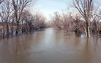
The Maumee River is a river in northwestern Ohio and northeastern Indiana in the United States. It is formed at Fort Wayne, Indiana by the confluence of the St. Joseph and St. Marys rivers, and meanders northeastwardly for through an agricultural region of glacial moraines before flowing into the...
in northwestern Ohio
Ohio
Ohio is a Midwestern state in the United States. The 34th largest state by area in the U.S.,it is the 7th‑most populous with over 11.5 million residents, containing several major American cities and seven metropolitan areas with populations of 500,000 or more.The state's capital is Columbus...
, and northeastern Indiana
Indiana
Indiana is a US state, admitted to the United States as the 19th on December 11, 1816. It is located in the Midwestern United States and Great Lakes Region. With 6,483,802 residents, the state is ranked 15th in population and 16th in population density. Indiana is ranked 38th in land area and is...
in the United States, with headwater tributaries rising in southern Michigan
Michigan
Michigan is a U.S. state located in the Great Lakes Region of the United States of America. The name Michigan is the French form of the Ojibwa word mishigamaa, meaning "large water" or "large lake"....
. It drains a primarily rural farming region in the watershed of Lake Erie
Lake Erie
Lake Erie is the fourth largest lake of the five Great Lakes in North America, and the tenth largest globally. It is the southernmost, shallowest, and smallest by volume of the Great Lakes and therefore also has the shortest average water residence time. It is bounded on the north by the...
. It shares its name with the St. Joseph River of Lake Michigan
St. Joseph River (Lake Michigan)
The St. Joseph River is a river, approximately long, in southern Michigan and northern Indiana in the United States. It drains a primarily rural farming area in the watershed of Lake Michigan...
, but the two run in generally opposite directions.
Origin
At the end of the Wisconsin glaciationWisconsin glaciation
The last glacial period was the most recent glacial period within the current ice age occurring during the last years of the Pleistocene, from approximately 110,000 to 10,000 years ago....
, the glacier's Erie Lobe retreated toward the northeast, leaving large debris deposits called moraine
Moraine
A moraine is any glacially formed accumulation of unconsolidated glacial debris which can occur in currently glaciated and formerly glaciated regions, such as those areas acted upon by a past glacial maximum. This debris may have been plucked off a valley floor as a glacier advanced or it may have...
s. The St. Joseph formed as a meltwater channel between the north limbs of two of these moraines, the Wabash Moraine on the west and the Fort Wayne Moraine on the east. At that time it joined the St. Marys River to drain into the Wabash River
Wabash River
The Wabash River is a river in the Midwestern United States that flows southwest from northwest Ohio near Fort Recovery across northern Indiana to southern Illinois, where it forms the Illinois-Indiana border before draining into the Ohio River, of which it is the largest northern tributary...
. Later, the shrinkage of Glacial Lake Maumee
Glacial Lake Maumee
Glacial Lake Maumee was a proglacial lake that was an ancestor of present-day Lake Erie. It formed about 14,000 years ago. As the Erie Lobe of the Wisconsin Glacier retreated at the end of the last ice age, it left meltwater in a previously-existing depressional area that was the valley of an...
, the ancestor of modern Lake Erie, brought about the opening of the modern Maumee River, which captured the flow of the St. Joseph and the St. Marys, causing the St. Marys to reverse its course to meet the flow of the St. Joseph almost head-on.
The St. Joseph today
The St. Joseph River forms in northern Williams County, OhioWilliams County, Ohio
Williams County is a county located in the U.S. state of Ohio. As of 2010, the population was 37,642. Its county seat is Bryan and is named for David Williams, one of the captors of John André in the American Revolutionary War.-Geography:According to the U.S...
, at the confluence of the East and West branches at 41°38′54"N 84°33′55"W Both branches rise in southern Hillsdale County, Michigan
Hillsdale County, Michigan
-Demographics:As of the census of 2000, there were 46,527 people, 17,335 households, and 12,550 families residing in the county. The population density was 78 people per square mile . There were 20,189 housing units at an average density of 34 per square mile...
. The headwaters of the East Branch are within 3 miles (4.8 km) of those of the St. Joseph River of Lake Michigan
St. Joseph River (Lake Michigan)
The St. Joseph River is a river, approximately long, in southern Michigan and northern Indiana in the United States. It drains a primarily rural farming area in the watershed of Lake Michigan...
. Both branches initially flow southeast, then turn to the southwest to flow across the northwestern corner of Ohio past Montpelier
Montpelier, Ohio
Montpelier is a village in Williams County, Ohio, United States. The population was 4,320 at the 2000 census.-Geography:Montpelier is located at ....
. The St. Joseph enters De Kalb County in northeastern Indiana, flowing southwest past Saint Joe and into the city of Fort Wayne
Fort Wayne, Indiana
Fort Wayne is a city in the US state of Indiana and the county seat of Allen County. The population was 253,691 at the 2010 Census making it the 74th largest city in the United States and the second largest in Indiana...
, where it meets the St. Marys River to form the Maumee River
Maumee River
The Maumee River is a river in northwestern Ohio and northeastern Indiana in the United States. It is formed at Fort Wayne, Indiana by the confluence of the St. Joseph and St. Marys rivers, and meanders northeastwardly for through an agricultural region of glacial moraines before flowing into the...
at 41°04′58"N 85°07′56"W.
Tributaries
From the mouth:- (left) Becketts Run
- (right) Tiernan Ditch
- (left) Ely Run
- (left) Cedar CreekCedar Creek (Indiana)Called Mes-kwah-wa-se-pe or "old redwood creek" by Native Americans, Cedar Creek is the largest tributary of the St. Joseph River, draining in northeastern Indiana. It is long, rising in northwestern DeKalb County and joining the St...
- Cedarville Reservoir
- (left) Nettlehorst Ditch
- (left) Warner Ditch
- (right) Wittmer Ditch
- (right) Haifley Ditch
- (left) Swartz-Carnahan Ditch
- Dunton Lake
- (right) Boger Ditch
- (left) Metcalf Ditch
- (right) Walker Ditch
- (left) Dilley Ditch
- (left) Wade Ditch
- (left) Bear Creek
- (right) North Branch Hursey Ditch
- (right) Carper Ditch
- (left) South Branch Hursey Ditch
- (right) Swander Ditch
- (right) North Branch Hursey Ditch
- (right) Nancy Davis Ditch
- (left) Sol Shank Ditch
- (right) Weicht Ditch
- (left) Sebert Ditch
- (right) Varner Ditch
- (left) Hoodelmier Ditch
- (right) Melissa Ditch
- (left) Buck Creek
- (left) Smith Ditch
- (right) Mason Ditch
- (left) Metcalf Ditch
- (right) Harwood Ditch
- (left) Metcalf Ditch
- (left) Christoffel Ditch
- (right) Willow Run
- (right) Amaden Ditch
- (right) Greens Ditch
- (right) Foulks Ditch
- (left) Peter Grube Ditch
- (left) Big Run
- (right) Ayford Ditch
- (left) Walters Ditch
- (right) Streeter Ditch
- (right) Praul Ditch
- (right) Mary Metcalf Ditch
- (left) Teutsch Ditch
- (left) Donnell Ditch
- (right) King Ditch
- (right) John Smith Ditch
- (left) Haverstolk Ditch
- (right) Ayford Ditch
- (left) Russell Run
- (left) Fish Creek
- (right) Cornell Ditch
- (left) Hiram Sweet Ditch
- (right) Baker Ditch
- (left) Hamilton Lake
- Black Creek
- (left) Haughey Ditch
- (left) Lillian Metz Ditch
- (right) Burch Ditch
- Black Creek
- Ball Lake
- (left) Myers Ditch
- Perfect Lake
- (left) West Branch Fish Creek
- (left) Donald Nunkle Ditch
- (left) Bluff Run
- (left) Bear Creek
- (left) Tamarack Ditch
- (left) Eagle Creek
- (right) North Branch Eagle Creek
- (left) Nettle Creek
- Nettle Lake
- (right) Mill Stream Drain
- Nettle Lake
- (right) East Branch St. Joseph River (rises in southwest Adams Township, Hillsdale County, MichiganAdams Township, Hillsdale County, MichiganAdams Township is a civil township of Hillsdale County in the U.S. state of Michigan. As of the 2000 census, the township population was 2,498.Adams township was separated from Moscow Township, Michigan in 1836.- Communities :...
at 41°54′17"N 84°33′52"W)- (left) Clear Fork
- (left) Silver Creek
- Merry Lake
- (left) Laird Creek
- (right) Nile Ditch
- (left) Ransom Ditch
- (left) Bird Creek
- Bird Lake
- (left) Newton Drain
- (left) Dillon Drain
- (left) Anderson Drain
- (left) Goose Creek
- (left) Lake Number One
- Lake Number Two
- Pittsford Millpond
- (right) Otto Drain
- Deer Lake
- Twin Lake
- (left) West Branch St. Joseph River
- Lake Seneca
- (left) outflow from Lake La Su An
- (right) East Fork West Branch St. Joseph River (rises in northwest Cambria Township, Hillsdale County, Michigan at 41°51′53"N 84°40′34"W)
- (left) Jonas Brown Drain
- (left) Carruthers Drain
- (right) outflow from Cub Lake
- Cambria Millpond
- (left) Cambria Drain
- (left) Meade Drain
- Bear Lake
- (left) Pike Lake
- Broom Lake
- Lake Wilson
- Bankers Lake
- (left) Pike Lake
- (left) West Fork West Branch St. Joseph River (rises from the outlfow of Rebeck Lake in northwest Camden Township, Hillsdale County, Michigan at 41°48′22"N 84°48′22"W)
- (left) Joe Drain
- (left) Prouty Drain
- Rebeck Lake
- Mead Lake
- Turner Lake
- Mead Lake
- Lake Seneca
Drainage basin
The St. Joseph River and tributaries drain all or portions of the following:- Allen County, IndianaAllen County, IndianaAs of the census of 2000, there were 331,849 people, 128,745 households, and 86,259 families residing in the county. The population density was 505 people per square mile . There were 138,905 housing units at an average density of 211 per square mile...
- Cedar Creek TownshipCedar Creek Township, Allen County, IndianaCedar Creek Township is one of twenty townships in Allen County, Indiana, USA. As of the 2000 census, its population was 10,288.-Geography:According to the United States Census Bureau, Cedar Creek Township covers an area of ; of this, is land and is water.-Cities, towns, villages:* Grabill*...
- Cedarville
- Eel River TownshipEel River Township, Allen County, IndianaEel River Township is one of twenty townships in Allen County, Indiana, USA. As of the 2000 census, its population was 3,004.-Geography:According to the United States Census Bureau, Eel River Township covers an area of ; of this, is land and is water.-Unincorporated towns:* Allen at Eel River...
- Fort WayneFort Wayne, IndianaFort Wayne is a city in the US state of Indiana and the county seat of Allen County. The population was 253,691 at the 2010 Census making it the 74th largest city in the United States and the second largest in Indiana...
- GrabillGrabill, IndianaGrabill is a town in Cedar Creek Township, Allen County, Indiana, United States. The population was 1,053 at the 2010 census. The town was founded in 1907 around the Grabill family home. Today it is known for the presence of antique stores and Amish farms...
- Milan TownshipMilan Township, Allen County, IndianaMilan Township is one of twenty townships in Allen County, Indiana, USA. Milan Township is located in east central Allen County, with the Maumee River meandering across the township. As of the 2000 census, its population was 3,503. The township is highly rural, with only 1,038 houses in the 2000...
- Perry TownshipPerry Township, Allen County, IndianaPerry Township is one of twenty townships in Allen County, Indiana, USA. As of the 2000 census, its population was 18,170.-Geography:According to the United States Census Bureau, Perry Township covers an area of ; of this, is land and is water.-Cities, towns, villages:* Fort Wayne * Huntertown...
- St. Joseph TownshipSt. Joseph Township, Allen County, IndianaSt. Joseph Township is one of twenty townships in Allen County, Indiana. As of the 2000 census, its population was 68,276.-Geography:St. Joseph Township covers an area of ; of this is water. The mostly suburban township includes portions of the cities of Fort Wayne and New Haven. The St...
- Springfield TownshipSpringfield Township, Allen County, IndianaSpringfield Township is one of twenty townships in Allen County, Indiana. As of the 2000 census, its population was 3,697. The principal town in Springfield Township is the village of Harlan.-Geography:...
- Washington TownshipWashington Township, Allen County, IndianaWashington Township is one of twenty townships in Allen County, Indiana. As of the 2000 census, its population was 33,105.-Geography:Washington Township covers an area of ; of this is water.-Adjacent townships:...
- Cedar Creek Township
- DeKalb County, IndianaDeKalb County, IndianaDeKalb County is a county located in the U.S. state of Indiana. Named for Revolutionary War hero Johann, Baron de Kalb , the county was created by the Indiana legislature in 1835 and organized in 1837. As of 2010, the population was 42,223...
- AuburnAuburn, IndianaAuburn is a city in DeKalb County, Indiana, United States. The population was 13,086 at the 2010 census. Founded in 1836 by Wesley Park , the city is the county seat of DeKalb County. Auburn is also known as Home of the Classics.-Geography:...
- Butler TownshipButler Township, DeKalb County, IndianaButler Township is one of fifteen townships in DeKalb County, Indiana. As of the 2000 census, its population was 1,805.-Geography:Butler Township covers an area of ; of this is water...
- ButlerButler, IndianaButler is a city in DeKalb County, Indiana, United States. The population was 2,684 at the 2010 census.-Geography:Butler is located at .According to the United States Census Bureau, the city has a total area of , all of it land.-Demographics:...
- Concord TownshipConcord Township, DeKalb County, IndianaConcord Township is one of fifteen townships in DeKalb County, Indiana. As of the 2000 census, its population was 1,212.-Geography:Concord Township covers an area of ; of this is water.-Unincorporated towns:* Concord* Orangeville...
- Franklin TownshipFranklin Township, DeKalb County, IndianaFranklin Township is one of fifteen townships in DeKalb County, Indiana. As of the 2000 census, its population was 1,264.-Geography:Franklin Township covers an area of ; of this is water...
- GarrettGarrett, IndianaGarrett is a city in Keyser Township, DeKalb County, Indiana, United States. The population was 6,286 at the 2010 census. Founded in 1875, Garrett was named for John W...
- Jackson TownshipJackson Township, DeKalb County, IndianaJackson Township is one of fifteen townships in DeKalb County, Indiana. As of the 2000 census, its population was 2,559.-Geography:Jackson Township covers an area of ; of this is water...
- Keyser TownshipKeyser Township, DeKalb County, IndianaKeyser Township is one of fifteen townships in DeKalb County, Indiana. As of the 2000 census, its population was 7,090.-Geography:Keyser Township covers an area of ; of this is water.-Cities and towns:* Altona* Auburn * Garrett...
- Newville TownshipNewville Township, DeKalb County, IndianaNewville Township is one of fifteen townships in DeKalb County, Indiana. As of the 2000 census, its population was 538.-Geography:Newville Township covers an area of ; of this is water.-Unincorporated towns:* Newville* Newville Center...
- Richland TownshipRichland Township, DeKalb County, IndianaRichland Township is one of fifteen townships in DeKalb County, Indiana. As of the 2000 census, its population was 1,258.-Geography:Richland Township covers an area of ; of this is water...
- Grant TownshipGrant Township, DeKalb County, IndianaGrant Township is one of fifteen townships in DeKalb County, Indiana. As of the 2000 census, its population was 3,087.-Geography:Grant Township covers an area of ; of this is water.-Cities and towns:* Auburn...
- Fairfield TownshipFairfield Township, DeKalb County, IndianaFairfield Township is one of fifteen townships in DeKalb County, Indiana. As of the 2000 census, its population was 1,319.-Geography:Fairfield Township covers an area of ; of this is water...
- Saint Joe
- Smithfield TownshipSmithfield Township, DeKalb County, IndianaSmithfield Township is one of fifteen townships in DeKalb County, Indiana. As of the 2000 census, its population was 1,658.-Geography:Smithfield Township covers an area of ; of this is water...
- Spencer TownshipSpencer Township, DeKalb County, IndianaSpencer Township is one of fifteen townships in DeKalb County, Indiana. As of the 2000 census, its population was 1,057.-Geography:Spencer Township covers an area of ; of this is water.-Adjacent townships:* Concord Township...
- SpencervilleSpencerville, IndianaSpencerville is an unincorporated town located in Spencer Township, DeKalb County, Indiana. The only covered bridge in DeKalb County is located in Spencerville.-Geography:Spencerville is located at .test...
- Stafford TownshipStafford Township, DeKalb County, IndianaStafford Township is one of fifteen townships in DeKalb County, Indiana. As of the 2000 census, its population was 282.-References:* * -External links:* *...
- Troy TownshipTroy Township, DeKalb County, IndianaTroy Township is one of fifteen townships in DeKalb County, Indiana. As of the 2000 census, its population was 322.-Geography:Troy Township covers an area of ; of this is water.-References:* * -External links:* *...
- Union TownshipUnion Township, DeKalb County, IndianaUnion Township is one of fifteen townships in DeKalb County, Indiana. As of the 2000 census, its population was 12,716.-Geography:Union Township covers an area of ; of this is water.-Adjacent townships:* Grant Township...
- WaterlooWaterloo, IndianaWaterloo is a town in Grant and Smithfield townships, DeKalb County, Indiana, United States. The population was 2,242 at the 2010 census.-Geography:Waterloo is located at ....
- Wilmington TownshipWilmington Township, DeKalb County, IndianaWilmington Township is one of fifteen townships in DeKalb County, Indiana. As of the 2000 census, its population was 4,118.-Geography:Wilmington Township covers an area of ; of this is water.-Adjacent townships:* Franklin Township...
- Auburn
- Noble County, IndianaNoble County, IndianaAs of the census of 2000, there were 46,275 people, 16,696 households, and 12,288 families residing in the county. The population density was 113 people per square mile . There were 18,233 housing units at an average density of 44 per square mile...
- AvillaAvilla, IndianaAvilla is a town in Allen Township, Noble County, Indiana, United States. The population was 2,401 at the 2010 census.-Geography:Avilla is located at .According to the United States Census Bureau, the town has a total area of ....
- Allen TownshipAllen Township, Noble County, IndianaAllen Township is one of thirteen townships in Noble County, Indiana, USA. As of the 2000 census, its population was 6,847.-Geography:According to the United States Census Bureau, Allen Township covers an area of ; of this, is land and is water.-Cities, towns, villages:* Avilla* Kendallville...
- Green TownshipGreen Township, Noble County, IndianaGreen Township is one of thirteen townships in Noble County, Indiana, USA. As of the 2000 census, its population was 1,769.-Geography:According to the United States Census Bureau, Green Township covers an area of ; of this, is land and is water.-Unincorporated towns:* Egans Point at * Green...
- LaOttoLaOtto, IndianaLaOtto is a small town in southeastern Noble County, Indiana. Located west of the current intersection of Indiana State Road 3 and Indiana State Road 205, it is 16 miles north of Fort Wayne and is also in close proximity to Kendallville and Auburn...
- Swan TownshipSwan Township, Noble County, IndianaSwan Township is one of thirteen townships in Noble County, Indiana. As of the 2000 census, its population was 2,337.-External links:* *...
- Wayne TownshipWayne Township, Noble County, IndianaWayne Township is one of thirteen townships in Noble County, Indiana. As of the 2000 census, its population was 10,365.-Geography:Sand Hill, the second highest point in Indiana, is located in northeastern Wayne Township, near the intersection of county roads 1000E and 1100N.-Major highways:* U.S....
- Avilla
- Steuben County, IndianaSteuben County, IndianaSteuben County is a county located in the northeast corner of the U.S. state of Indiana. As of 2010, the population was 34,185. The county seat is Angola...
- Clear Lake TownshipClear Lake Township, Steuben County, IndianaClear Lake Township is one of twelve townships in Steuben County, Indiana, USA. As of the 2000 census, its population was 687.-Geography:The smallest of all Steuben County townships, Clear Lake Township covers an area of ; of this, or 13.67% is water...
- HamiltonHamilton, IndianaHamilton is a town located on the border of Steuben County, Indiana and DeKalb County, Indiana. In Steuben County, it is in Otsego Township, and in DeKalb County it is in Franklin Township. The population was 1,532 at the 2010 census.- History :...
- Otsego TownshipOtsego Township, Steuben County, IndianaOtsego Township is one of twelve townships in Steuben County, Indiana, USA. As of the 2000 census, its population was 2,546.-Geography:Otsego Township covers an area of ; of this, or 4.17 percent is water. Lakes in this township include Ball Lake, Fee Lake, Hamilton Lake, Jackson Lake, Johnson...
- Richland TownshipRichland Township, Steuben County, IndianaRichland Township is one of twelve townships in Steuben County, Indiana, USA. As of the 2000 census, its population was 538, making it the smallest township in the county.-Geography:...
- York TownshipYork Township, Steuben County, IndianaYork Township is one of twelve townships in Steuben County, Indiana, USA. As of the 2000 census, its population was 670.-Geography:York Township covers an area of...
- Clear Lake Township
- Defiance County, OhioDefiance County, OhioAs of the census of 2000, there were 39,500 people, 15,138 households, and 11,020 families residing in the county. The population density was 96 people per square mile . There were 16,040 housing units at an average density of 39 per square mile...
- Milford TownshipMilford Township, Defiance County, OhioMilford Township is one of the twelve townships of Defiance County, Ohio, United States. The 2000 census found 1,013 people in the township.-Geography:...
- Milford Township
- Williams County, OhioWilliams County, OhioWilliams County is a county located in the U.S. state of Ohio. As of 2010, the population was 37,642. Its county seat is Bryan and is named for David Williams, one of the captors of John André in the American Revolutionary War.-Geography:According to the U.S...
- Bridgewater TownshipBridgewater Township, Williams County, OhioBridgewater Township is one of the twelve townships of Williams County, Ohio, United States. The 2000 census found 1,401 people in the township.-Geography:...
- BlakesleeBlakeslee, OhioBlakeslee is a village in Williams County, Ohio, United States. The population was 130 at the 2000 census.The community was named after Schuyler E...
- Center TownshipCenter Township, Williams County, OhioCenter Township is one of the twelve townships of Williams County, Ohio, United States. The 2000 census found 3,056 people in the township.-Geography:Located in the southern part of the county, it borders the following townships:*Superior Township - north...
- EdgertonEdgerton, OhioEdgerton is a village in Williams County, Ohio, United States. The population was 2,117 at the 2000 census.-Geography:Edgerton is located at ....
- EdonEdon, OhioEdon is a village in Williams County, Ohio, United States. The population was 898 at the 2000 census.-Geography:Edon is located at .According to the United States Census Bureau, the village has a total area of , all of it land....
- Florence TownshipFlorence Township, Williams County, OhioFlorence Township is one of the twelve townships of Williams County, Ohio, United States. The 2000 census found 2,115 people in the township, 1,087 of whom lived in the unincorporated portions of the township.-Geography:...
- Madison TownshipMadison Township, Williams County, OhioMadison Township is one of the twelve townships of Williams County, Ohio, United States. The 2000 census found 2,539 people in the township, 1,079 of whom lived in the unincorporated portions of the township.-Geography:...
- MontpelierMontpelier, OhioMontpelier is a village in Williams County, Ohio, United States. The population was 4,320 at the 2000 census.-Geography:Montpelier is located at ....
- Northwest TownshipNorthwest Township, Williams County, OhioNorthwest Township is one of the twelve townships of Williams County, Ohio, United States. The 2000 census found 1,384 people in the township.-Geography:...
- PioneerPioneer, OhioPioneer is a village in Williams County, Ohio, United States. The population was 1,369 at the 2010 census.-History:Earliest recorded settlers of Pioneer were P.W. Norris and Owen McCarty , who were hired to clear James A. Rogers land in 1842-3. That land was section 17 of Williams County...
- St. Joseph TownshipSt. Joseph Township, Williams County, OhioSt. Joseph Township is one of the twelve townships of Williams County, Ohio, United States. The 2000 census found 3,227 people in the township, 1,821 of whom lived in the unincorporated portions of the township.-Geography:...
- Superior TownshipSuperior Township, Williams County, OhioSuperior Township is one of the twelve townships of Williams County, Ohio, United States. The 2000 census found 5,769 people in the township, 1,452 of whom lived in the unincorporated portions of the township.-Geography:...
- Bridgewater Township
- Hillsdale County, MichiganHillsdale County, Michigan-Demographics:As of the census of 2000, there were 46,527 people, 17,335 households, and 12,550 families residing in the county. The population density was 78 people per square mile . There were 20,189 housing units at an average density of 34 per square mile...
- Adams TownshipAdams Township, Hillsdale County, MichiganAdams Township is a civil township of Hillsdale County in the U.S. state of Michigan. As of the 2000 census, the township population was 2,498.Adams township was separated from Moscow Township, Michigan in 1836.- Communities :...
- Amboy TownshipAmboy Township, MichiganAmboy Township is a civil township of Hillsdale County in the U.S. state of Michigan. As of the 2000 census, the township population was 1,224....
- Cambria TownshipCambria Township, MichiganCambria Township is a civil township of Hillsdale County in the U.S. state of Michigan. The population was 2,546 at the 2000 census.- Communities :...
- Camden TownshipCamden Township, MichiganCamden Township is a civil township of Hillsdale County in the U.S. state of Michigan. The population was 2,088 at the 2000 census.The villages of Camden and Montgomery are within the township.- History :...
- CamdenCamden, MichiganCamden is a village in Camden Township, Hillsdale County in the U.S. state of Michigan. The population was 550 at the 2000 census.-Geography:According to the United States Census Bureau, the village has a total area of , all land.-Demographics:...
- Jefferson TownshipJefferson Township, Hillsdale County, MichiganJefferson Township is a civil township of Hillsdale County in the U.S. state of Michigan. The population was 3,141 at the 2000 census.-Communities:...
- Osseo
- Pittsford TownshipPittsford Township, MichiganPittsford Township is a civil township of Hillsdale County in the U.S. state of Michigan. The population was 1,600 at the 2000 census.-Communities:...
- Ransom TownshipRansom Township, MichiganRansom Township is a civil township of Hillsdale County in the U.S. state of Michigan. The population was 982 at the 2000 census.-Communities:*Ransom is an unincorporated community within the township at .-Geography:...
- Reading TownshipReading Township, MichiganReading Township is a civil township of Hillsdale County in the U.S. state of Michigan. The population was 1,781 at the 2000 census.The City of Reading is situated within the township on M-49, but is administratively autonomous.-Geography:...
- Wheatland TownshipWheatland Township, Hillsdale County, MichiganWheatland Township is a civil township of Hillsdale County in the U.S. state of Michigan. The population was 1,258 at the 2000 census.-Communities:*Church's Corners is an unincorporated community within the township....
- Woodbridge TownshipWoodbridge Township, MichiganWoodbridge Township is a civil township of Hillsdale County in the U.S. state of Michigan. The population was 1,337 at the 2000 census.-Communities:*Frontier is an unincorporated community within the township at...
- Wright TownshipWright Township, Hillsdale County, MichiganWright Township is a civil township of Hillsdale County in the U.S. state of Michigan. The population was 1,788 at the 2000 census.-Communities:*The village of Waldron is within the township....
- Adams Township
See also
- List of Indiana rivers
- List of Michigan rivers
- List of Ohio rivers
- USS St. Joseph's RiverUSS St. Joseph's River (LSM(R)-527)USS St. Joseph's River was laid down on 19 May 1945 by the Brown Shipbuilding Co., Inc., in Houston, Texas; she was launched on 16 June 1945 and commissioned on 24 August 1945.-Service history:...
, a World War IIWorld War IIWorld War II, or the Second World War , was a global conflict lasting from 1939 to 1945, involving most of the world's nations—including all of the great powers—eventually forming two opposing military alliances: the Allies and the Axis...
era US Navy vessel named after this river.
Further reading
- Water Resource Availability in the Maumee River Basin, Indiana, Water Resource Assessment 96-5, Indianapolis:Indiana Department of Natural Resources, Division of Water, 1996, p. 46.
- Sunderman, Jack A., "The Three Faces of Cedar Creek," ACRES Quarterly, v. 39, no. 4 (Fall 2000), pp. 6-7.