
Feather River
Encyclopedia
- This article refers to the river in California. For other uses see Feather River (disambiguation)Feather River (disambiguation)Feather River may refer to:Rivers*Feather River in California in the United States, a principal tributary of the Sacramento River*Feather River in Alaska in the United States*Feather River in Idaho in the United StatesOther places...
The Feather River is the principal tributary of the Sacramento River
Sacramento River
The Sacramento River is an important watercourse of Northern and Central California in the United States. The largest river in California, it rises on the eastern slopes of the Klamath Mountains, and after a journey south of over , empties into Suisun Bay, an arm of the San Francisco Bay, and...
, in the Sacramento Valley
Sacramento Valley
The Sacramento Valley is the portion of the California Central Valley that lies to the north of the San Joaquin-Sacramento Delta in the U.S. state of California. It encompasses all or parts of ten counties.-Geography:...
of Northern California
Northern California
Northern California is the northern portion of the U.S. state of California. The San Francisco Bay Area , and Sacramento as well as its metropolitan area are the main population centers...
. The river's main stem
Main Stem
"Main Stem" is 1942 instrumental by Duke Ellington and His Famous Orchestra. Although recorded in 1942, the single would not be released until 1944 where it was Duke Ellington's last of four number one's on the Harlem Hit Parade. "Main Stem" would also peak at number twenty on the pop chart"Main...
is about 71 miles (114.3 km) long. Its length to its most distant headwater tributary is about 220 miles (354.1 km). Its drainage basin
Drainage basin
A drainage basin is an extent or an area of land where surface water from rain and melting snow or ice converges to a single point, usually the exit of the basin, where the waters join another waterbody, such as a river, lake, reservoir, estuary, wetland, sea, or ocean...
is about 6000 square miles (15,539.9 km²). The main stem Feather River begins in Lake Oroville
Lake Oroville
Lake Oroville, also known as Lake Edmonston, is a reservoir in the U.S. state of California, formed by the Oroville Dam across the Feather River. The lake is situated in the foothills of the Sierra Nevada about northeast of Oroville. At over , it is one of the largest reservoirs in California,...
, where its four long tributary forks join together—the South Fork, Middle Fork, North Fork, and West Branch Feather Rivers. These and other tributaries drain part of the northern Sierra Nevada, and the extreme southern Cascades
Cascade Range
The Cascade Range is a major mountain range of western North America, extending from southern British Columbia through Washington and Oregon to Northern California. It includes both non-volcanic mountains, such as the North Cascades, and the notable volcanoes known as the High Cascades...
, as well as a small portion of the Sacramento Valley
Sacramento Valley
The Sacramento Valley is the portion of the California Central Valley that lies to the north of the San Joaquin-Sacramento Delta in the U.S. state of California. It encompasses all or parts of ten counties.-Geography:...
. The river's drainage basin above Lake Oroville is 3222 square miles (8,344.9 km²), or about 83% of the whole.
The Feather River has a rich history of gold mining in the 19th century. It provides water to central and southern California, being the main source of water for the California State Water Project
California State Water Project
The California State Water Project, commonly known as the SWP , is the world's largest publicly built and operated water and power development and conveyance system. The SWP was designed and is operated by the California Department of Water Resources...
. Its water is also used for hydroelectricity
Hydroelectricity
Hydroelectricity is the term referring to electricity generated by hydropower; the production of electrical power through the use of the gravitational force of falling or flowing water. It is the most widely used form of renewable energy...
generation.
The Feather is unique in that two of its tributaries, the North Fork and Middle Fork, originate east of the Sierra Nevada in the Diamond Mountains
Diamond Mountains (California)
----The Diamond Mountains are a mountain range in Plumas County, California, which includes several named points on the Sierra Crest ....
and breach the crest of the Sierras as they flow west.
Course
The river rises in four main forks in the Sierra Nevada which unite as arms of the Lake Oroville reservoir in the foothills 5 miles (8 km) northeast of OrovilleOroville, California
Oroville is the county seat of Butte County, California. The population was 15,506 at the 2010 census, up from 13,004 at the 2000 census...
in eastern Butte County
Butte County, California
Butte County is a county located in the Central Valley of the US state of California, north of the state capital of Sacramento. As of the 2010 census, it had a population of 220,000. The county seat is Oroville. Butte County is the "Land of Natural Wealth and Beauty."Butte County is watered by the...
. In terms of drainage areas the largest is the North Fork, which drains about 60% of the entire upper Feather River watershed. The Middle Fork is the second largest, draining about 32% of the upper basin. The South Fork and the West Branch are much smaller, each drains less than 5% of the upper basin. The main stem Feather River begins at Oroville Dam, the outlet of Lake Oroville. From there the river flows generally south across the Sacramento Valley
Sacramento Valley
The Sacramento Valley is the portion of the California Central Valley that lies to the north of the San Joaquin-Sacramento Delta in the U.S. state of California. It encompasses all or parts of ten counties.-Geography:...
, east of the Sutter Buttes
Sutter Buttes
The Sutter Buttes are a small circular complex of eroded volcanic lava domes which rise as buttes above the flat plains of the Central Valley of California in the United States. The highest peak, South Butte, reaches about above sea level. The Buttes are located just outside of Yuba City,...
, past Oroville and Yuba City
Yuba City, California
Yuba City is a Northern California city, founded in 1849. It is the county seat of Sutter County, California, United States. The population was 64,925 at the 2010 census....
-Marysville
Marysville, California
Marysville is the county seat of Yuba County, California, United States. The population was 12,072 at the 2010 census, down from 12,268 at the 2000 census. It is included in the Yuba City Metropolitan Statistical Area, often referred to as the Yuba-Sutter Area after the two counties, Yuba and...
. The Feather receives the Yuba River
Yuba River
The Yuba River is a tributary of the Feather River in the Sacramento Valley of the U.S. state of California. It is one of the Feather's most important branches, providing about a third of its flow. The main stem of the river is about long, and its headwaters are split into North, Middle and South...
from the east at Yuba City and the Bear River from the east 15 miles (24.1 km) south of Yuba City. It empties into the Sacramento River from the north, about 20 miles (32.2 km) northwest of Sacramento.
North Fork

North Fork Feather River
The North Fork Feather River is a watercourse of the northern Sierra Nevada in the U.S. state of California. It flows generally southwards from its headwaters near Lassen Peak to Lake Oroville, a reservoir formed by Oroville Dam in the foothills of the Sierra, where it runs into the Feather River....
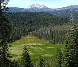
begins in Feather River Meadows at the junction of Rice Creek and South Arm Rice Creek, 40°21′47"N 120°27′5"W. The names and confluence locations of the streams in this area were changed by the Board on Geographic Names in 1927. USGS topographic map
Topographic map
A topographic map is a type of map characterized by large-scale detail and quantitative representation of relief, usually using contour lines in modern mapping, but historically using a variety of methods. Traditional definitions require a topographic map to show both natural and man-made features...
s, as of 1995, are mislabeled for South Arm, North Arm Rice Creek, Rice Creek and North Fork Feather River. Rice Creek, labeled North Arm Rice Creek on USGS topo maps, flows south from its source at Cold Boiling Lake, 40°27′24"N 121°29′4"W, in Lassen Volcanic National Park
Lassen Volcanic National Park
Lassen Volcanic National Park is a United States National Park in northeastern California. The dominant feature of the park is Lassen Peak; the largest plug dome volcano in the world and the southern-most volcano in the Cascade Range...
, through Crumbaugh Lake, and south to join the South Arm Rice Creek, forming the North Fork Feather River.
The North Fork's length is about 102 miles (164.2 km), or about 112 miles (180.2 km) including Rice Creek. The total length of the Feather River from the source of Rice Creek to the Sacramento River is about 187 miles (300.9 km).
From its source in Feather River Meadows the North Fork flows east. A tributary emerges from Buzzard Springs and flows into the Stump Ranch Marsh Area, where it joins the North Fork, which then flows southeast to Lake Almanor
Lake Almanor
Lake Almanor is a large artificial lake in northwestern Plumas County, northeastern California. The reservoir has a capacity of and a maximum depth of about 90 feet...
, a reservoir created by Canyon Dam. Below Canyon Dam the North Fork flows generally southwest through the Sierra Nevada, receiving the East Branch North Fork Feather River near Belden
Belden, California
Belden is a census-designated place in Plumas County, California, United States. Belden is located on the North Fork Feather River, southwest of Caribou. The population was 22 at the 2010 census, down from 26 at the 2000 census.-History:...
.
The East Branch is one of the major tributaries of the Feather River system. It originates at 40°2′16"N 120°58′57"W, at the confluence of Indian Creek and Spanish Creek. Indian Creek is another long and important tributary, flowing from its source at 40°18′34"N 120°41′36"W, on the south slopes of Diamond Mountain, south and west, through Indian Valley and north of American Valley. Indian Creek joins Spanish Creek to form the East Branch North Fork Feather River. The longest tributary of Indian Creek is Last Chance Creek, which rises in eastern Plumas County at 40°0′47"N 120°12′10"W, south of Honey Lake
Honey Lake
Honey Lake is an endorheic sink within the Honey Lake Valley located in northeastern California, near the Nevada border. Summer evaporation reduces the lake to a lower level of 12 km² and creates an alkali flat....
, and flows generally west, joining Indian Creek at the western end of Genesee Valley. From its source at the Indian and Spanish Creeks confluence, the East Branch North Fork flows west past Twain
Twain, California
Twain is a census-designated place in Plumas County, California, United States. As of the 2010 census, the CDP population was 82, down from 87 at the 2000 census.-Geography:Twain is located at ....
and joins the North Fork near Belden.
The East Branch's main stem length is about 18 miles (29 km). Indian Creek is about 52.5 miles (84.5 km) long, and Last Chance Creek is about 45 miles (72.4 km) long. The East Branch's most distant headwater is Last Chance Creek's source. The total length from the mouth of the East Branch to the source of Last Chance Creek is about 92 miles (148.1 km). The total length of the Feather River from the source of Last Chance Creek to the Sacramento River is about 219 miles (352.4 km).
The North Fork continues flowing south below the East Branch confluence. Bucks Creek, which drains Bucks Lake near Bucks Lake, California
Bucks Lake, California
Bucks Lake is a census-designated place in Plumas County, California, United States. Bucks Lake is located on the south shore of Bucks Lake, west-southwest of Quincy...
, joins from east. The North Fork flows southeast into Butte County, becoming the northern arm of Lake Oroville. Before Oroville Dam was built the mouth of the North Fork was located at 39°33′20"N 121°28′0"W. After the North Fork's mouth was inundated by Lake Oroville the North Fork's mouth was changed to be at 39°43′27"N 121°28′19"W, according to the USGS.
The North Fork Feather River drains 2156 square miles (5,584 km²)—1131 square miles (2,929.3 km²) for the North Fork itself and 1025 square miles (2,654.7 km²) for East Branch North Fork. The average discharge for the two streams is about 1930 cuft/s for the North Fork, and 1000 cuft/s for the East Branch.
Middle Fork
The Middle Fork Feather RiverMiddle Fork Feather River
The Middle Fork Feather River is a major river in Plumas and Butte Counties in the U.S. state of California. Nearly long, it drains about of the rugged northern Sierra Nevada range....
begins at 39°48′49"N 120°22′46"W, in southeastern Plumas County about 0.5 mile (0.80467 km) south of Beckwourth
Beckwourth, California
Beckwourth is a census-designated place in Plumas County, California, United States. Beckwourth is located on the Middle Fork Feather River east of Portola...
, at the north end of the Sierra Valley. It is formed by the joining of a number of tributaries that merge in an inverted river delta
Inverted river delta
An inverted river delta is special category of river delta in which the narrow end of the delta emerges on the seafront and the wide end is located further inland, so that with respect to the seafront, the locations of both ends of the delta are inverted....
wetland with a complex network of irrigation ditches and drains called the Sierra Valley Channels. A number of creeks merge in the Sierra Valley, the longest of which is Little Last Chance Creek, which originates at 40°1′9"N 120°13′15"W and flows south through Frenchman Lake and Last Chance Valley to the Sierra Valley, where it divides into two distributary
Distributary
A distributary, or a distributary channel, is a stream that branches off and flows away from a main stream channel. They are a common feature of river deltas. The phenomenon is known as river bifurcation. The opposite of a distributary is a tributary...
channels. Other tributaries that join to form the Middle Fork in the Sierra Valley include Carman Creek, Fletcher Creek, Turner Creek, Berry Creek, Hamlin Creek, Sierraville Creek, and Smithneck Creek.
Flowing west through the mountains from its source in the Sierra Valley the Middle Fork is joined by Big Grizzly Creek, which drains Lake Davis to the north. Then the river flows by Portola
Portola, California
Portola is the only incorporated city in Plumas County, California, United States. The population was 2,104 at the 2010 census, down from 2,227 at the 2000 census...
and Delleker in the Humbug Valley. Sulphur Creek joins in the Mohawk Valley, just upriver from Graegle
Graeagle, California
Graeagle is a census-designated place in Plumas County, California, United States. The population was 737 at the 2010 census, down from 831 at the 2000 census.-History:...
. Continuing west, the Middle Fork passes the small settlement of Sloat in Long Valley, then enters a long and deep gorge. It is joined by numerous small tributaries. The Pacific Crest Trail
Pacific Crest Trail
The Pacific Crest Trail is a long-distance mountain hiking and equestrian trail on the Western Seaboard of the United States. The southern terminus is at the California border with Mexico...
crosses near Onion Valley Creek. The Middle Fork turns to flow southwest and south, through Bald Rock Canyon and into the middle arm of Lake Oroville.
The Middle Fork's main stem length is about 98 miles (157.7 km), or about 111 miles (178.6 km) including Little Last Chance Creek. The total length of the Feather River from the source of Little Last Chance Creek to the Sacramento River is about 220 miles (354.1 km).
South Fork
The South Fork Feather RiverSouth Fork Feather River
The South Fork Feather River is a Lake Oroville tributary in the south portion of the Middle Fork Feather Watershed which drains the Little Grass Valley, California and has several reservoirs....
originates in southern Plumas County near the Plumas-Sierra county line, at 39°46′48"N 120°52′26"W. It heads on the southwest slope of Pilot Peak, just north of Gibsonville Ridge and Bunker Hill Ridge. It flows west and southwest to Little Grass Valley Reservoir
Little Grass Valley, California
Little Grass Valley is a lake located in Plumas County, California, USA. As of the 2010 census, the census-designated place had a total population of 2.-Geography:Little Grass Valley is located at 39°42'59" North, 120°58'35" West ....
, an impoundment created by Little Grass Valley Dam. Below the dam the South Fork flows southwest between Mooreville Ridge and Lumpkin Ridge and enters Butte County. Just before entering Lake Oroville the Ponderosa Diversion Dam impounds the South Fork in the Ponderosa Reservoir. Below the dam the river becomes the south arm of Lake Oroville. The mouth of the South Fork is considered to be where the river empties into Ponderosa Reservoir, 39°32′55"N 121°16′39"W. The mouth was formerly located farther west at 39°33′5"N 121°25′20"W, until it was inundated by Lake Oroville. The total stream distance from the head of the South Fork to the juncture with the Middle Fork in Lake Oroville is 44.5 miles (71.6 km).
West Branch
The 46.4 miles (74.7 km) West Branch Feather RiverWest Branch Feather River
The West Branch Feather River is a Lake Oroville tributary that flows generally north-to-south in the North Fork Feather Watershed near the watershed's drainage divide with the...
, sometimes called the West Fork Feather River, has a drainage area that is small but slightly larger than that of the South Fork. It originates in Butte County at 40°4′40"N 121°25′24"W, in Lassen National Forest
Lassen National Forest
Lassen National Forest is a national forest of 1,700 square miles in northeastern California. It is named after pioneer Peter Lassen, who mined, ranched and promoted the area to emigrant parties in the 1850s.- Overview :...
. It flows southwest through Snag Lake and by Coon Hollow, after which it is joined by Philbrook Creek, which drains Philbook Reservoir to the east. From there the West Branch flows more directly south and leaves Lassen National Forest. It is joined by Fish Creek and Last Chance Creek (there are several streams named Last Chance Creek in the Feather River watershed). Downstream from Last Chance Creek a diversion dam draws off some of the West Branch's water. The diverted water flows into Hendricks Canal, a 8.66 miles (13.9 km) long conduit composed of ditch, flume, and tunnel sections, with a capacity of 125 cuft/s. Along with other facilities, such as Philbrook Reservoir, Hendricks Canal is part of the Toadtown development, which conveys water through the several canals and powerhouses. The water ultimately empties into Butte Creek, a tributary of the Sacramento River. Another diversion dam on the West Branch Feather River near Magalia
Magalia, California
Magalia is a census-designated place in Butte County, California, United States. The population was 11,310 at the 2010 census.-History:...
, called the Magalia 73 Dam, conveys water into the Upper Miocene Canal, which runs to Kunkle Reservoir and the Lime Saddle Powerhouse on Lake Oroville. From the powerhouse water is carried by the Middle Miocene Canal to the Coal Canyon Powerhouse and on into the Oroville-Thermalito Complex
Oroville-Thermalito Complex
The Oroville-Thermalito Complex is a group of facilities and structures located in and around the city of Oroville, California. The complex serves as the headwaters for, and therefore is the most vital facility of, the California Department of Water Resources' State Water Project, the world's...
. The Miocene Canal and Lime Saddle Powerhouse are part of the DeSabla Regional Bundle of hydroelectric facilities operated by the Pacific Gas and Electric Company
Pacific Gas and Electric Company
The Pacific Gas and Electric Company , commonly known as PG&E, is the utility that provides natural gas and electricity to most of the northern two-thirds of California, from Bakersfield almost to the Oregon border...
.
The West Branch Feather River flows by Stirling City
Stirling City, California
Stirling City is a census-designated place in Butte County, California, located on Paradise Ridge in the western foothills of the Sierra Nevada. Contrary to its name, Stirling City is an unincorporated community. Its ZIP Code is 95978 and area code 530. It lies at an elevation of 3570 feet...
and is joined by Big Kimshew Creek and the Little West Fork West Branch Feather River. Concow Creek, flowing southwest from Concow Reservoir, joins just before the West Branch empties into the northwest arm of Oroville Lake, near Paradise
Paradise, California
Paradise is an incorporated town in Butte County, in the northwest foothills of California's Central Valley, in the Sierra. The town is considered part of the Chico Metropolitan Area. The population was 26,218 at the 2010 census, down from 26,408 at the 2000 census...
.
Drainage basin
The United States Forest ServiceUnited States Forest Service
The United States Forest Service is an agency of the United States Department of Agriculture that administers the nation's 155 national forests and 20 national grasslands, which encompass...
manages over 80% of the Feather River's upper watershed, in the mountains above Lake Oroville. The alluvial valleys
Alluvium
Alluvium is loose, unconsolidated soil or sediments, eroded, deposited, and reshaped by water in some form in a non-marine setting. Alluvium is typically made up of a variety of materials, including fine particles of silt and clay and larger particles of sand and gravel...
in this area are mostly privately owned and used for livestock grazing and hay production. In terms of drainage area, the North Fork Feather River is the largest, accounting for about 60% of the total basin above Lake Oroville. The Middle Fork drains about 32% of the upper basin. Other forks and tributaries drain much smaller areas—the West Fork accounts for about 5%, and the South Fork about 3%.
There are several important valleys in the otherwise mountainous upper basin. The Sierra Valley, about 470 square miles (1,217.3 km²), is located where a number of tributaries come together to form the Middle Fork. The valley's elevation is nearly 5000 feet (1,524 m). It is known as the largest high-alpine valley in the continental United States. It also lies along the Pacific Flyway
Pacific Flyway
The Pacific Flyway is a major north-south route of travel for migratory birds in America, extending from Alaska to Patagonia. Every year, migratory birds travel some or all of this distance both in spring and in fall, following food sources, heading to breeding grounds, or travelling to...
, making it an important seasonal home to migrating birds. Settlements in the valley include Portola
Portola, California
Portola is the only incorporated city in Plumas County, California, United States. The population was 2,104 at the 2010 census, down from 2,227 at the 2000 census...
, Loyalton
Loyalton, California
Loyalton is a city in Sierra County, California, United States. The population was 769 at the 2010 census, down from 862 at the 2000 census. The ZIP code for the community is 96118. Wired telephone numbers in the community follow the format 993-xxxx. The town is near the north extent of State...
, Sierraville
Sierraville, California
Sierraville is a census-designated place in Sierra County, California, United States. It is at the southern end of the huge Sierra Valley which is used primarily as pasture and is also at the junction of California State Route 49 and California State Route 89 southwest of Loyalton. Sierraville has...
, and Beckwourth
Beckwourth, California
Beckwourth is a census-designated place in Plumas County, California, United States. Beckwourth is located on the Middle Fork Feather River east of Portola...
.
The American Valley is located in the middle of the upper Feather basin. Spanish Creek and Greenhorn Creek join in the valley, and Spanish Creek flows north to join Indian Creek, forming the East Branch North Fork Feather River. American Valley is about 3410 feet (1,039.4 m) in elevation and supports a population of about 6,500. The largest community is Quincy
Quincy, California
Quincy is a census-designated place and the county seat of Plumas County, California. The population was 1,728 at the 2010 census, down from 1,879 at the 2000 census. Quincy is named after the city of Quincy, Illinois...
. Historically, American Valley was a floodplain, but settlers drained the wet meadows to create pasture for cattle and fields for hay production. Today the stream channels are deeply incised and floods rare. These alternations affected the valley's ecology. Beavers, which were once prevalent, were nearly eliminated. This in turn had a large effect on the valley's hydrology.
Indian Valley is the third important alluvial valley of the upper basin. It is located along lower Indian Creek, near its confluence with Lights Creek. By the end of the 19th century Indian Valley was considered the most important valley of Plumas County and its swampy land was developed into a prosperous agricultural landscape. Communities in Indian Valley include Greenville
Greenville, California
Greenville is a census-designated place in Plumas County, California, United States, on the north-west side of Indian Valley. The population was 1,129 at the 2010 census, down from 1,160 at the 2000 census.-Geography:...
and Taylorsville
Taylorsville, California
Taylorsville is a census-designated place in Plumas County, California, United States. The population was 150 at the 2010 census, down from 154 at the 2000 census.-Geography:Taylorsville is located at ....
.
Two large endorheic lakes, Eagle Lake
Eagle Lake (Lassen County)
Eagle Lake is a lake in Lassen County approximately 15 miles north of Susanville, California. It is the second largest natural lake entirely in the state of California, United States....
and Honey Lake
Honey Lake
Honey Lake is an endorheic sink within the Honey Lake Valley located in northeastern California, near the Nevada border. Summer evaporation reduces the lake to a lower level of 12 km² and creates an alkali flat....
, lie north of the upper Feather River basin, across the Diamond Mountains.
History
Historically, the MaiduMaidu
The Maidu are a group of Native Americans who live in Northern California. They reside in the central Sierra Nevada, in the drainage area of the Feather and American Rivers...
were the main Native American
Native Americans in the United States
Native Americans in the United States are the indigenous peoples in North America within the boundaries of the present-day continental United States, parts of Alaska, and the island state of Hawaii. They are composed of numerous, distinct tribes, states, and ethnic groups, many of which survive as...
inhabitants of the upper Feather River basin's American, Indian, and Sierra Valleys. Maidu villages were located in the Big Meadows area, now inundated by Lake Almanor, and in Indian Valley where Quincy
Quincy, California
Quincy is a census-designated place and the county seat of Plumas County, California. The population was 1,728 at the 2010 census, down from 1,879 at the 2000 census. Quincy is named after the city of Quincy, Illinois...
is now located. The Maidu migrated to the Sierra Valley in the spring and summer, but did not stay during the harsh winters. The Washoe
Washoe people
The Washoe are a Great Basin tribe of Native Americans, living in California and Nevada. The name "Washoe" is derived from the autonym waashiw meaning "people from here" in the Washo language .-Territory:Washoe people have lived in the Great Basin for at least the last 6000 years...
hunted in the upper Feather River basin, especially in Long Valley, Sierra Valley, and Mohawk Valley. There is evidence of Paiute and Washoe settlements in the Long Valley area.
The 1849 California Gold Rush
California Gold Rush
The California Gold Rush began on January 24, 1848, when gold was found by James W. Marshall at Sutter's Mill in Coloma, California. The first to hear confirmed information of the gold rush were the people in Oregon, the Sandwich Islands , and Latin America, who were the first to start flocking to...
brought a flood of prospectors and settlers to the region. The American and Indian Valleys were settled in the 1850s. In the Sierra Valley the first settlers arrived in 1852.
The Feather River Route
The Western Pacific RailroadWestern Pacific Railroad
The Western Pacific Railroad was a Class I railroad in the United States. It was formed in 1903 as an attempt to break the near-monopoly the Southern Pacific Railroad had on rail service into northern California...
operated a railroad through the Feather River canyon. This route was selected because it leads to a low pass over the Sierra Nevada mountains. The Western Pacific California Zephyr
California Zephyr
The California Zephyr is a long passenger train route operated by Amtrak in the midwestern and western United States.It runs from Chicago, Illinois, in the east to Emeryville, California, in the west, passing through the states of Illinois, Iowa, Nebraska, Colorado, Utah, Nevada, and California...
trains used this route and had a feather in their logo to represent the river.
River modifications
Since 1967, the headwaters of the Feather River at the confluence of its four forks have been submerged under the waters of Lake OrovilleLake Oroville
Lake Oroville, also known as Lake Edmonston, is a reservoir in the U.S. state of California, formed by the Oroville Dam across the Feather River. The lake is situated in the foothills of the Sierra Nevada about northeast of Oroville. At over , it is one of the largest reservoirs in California,...
, created by the construction of Oroville Dam
Oroville Dam
Oroville Dam spans the Feather River about northeast of the city of Oroville, California. It forms Lake Oroville, which stores water for irrigation, flood control, municipal water supply and hydroelectricity generation in California's Sacramento Valley. The dam lies in the foothills of the Sierra...
in 1967. At about 770 feet (234.7 m) high, it is the tallest dam in the United States and wields nearly complete control over the flow of the Feather River by creating one of the largest reservoirs in California. The dam was built with the purpose of preventing the frequent floods that often inundated this part of the Sacramento Valley, and to store water for agricultural uses downstream during the dry season.
The Feather's main tributaries, the Yuba and the Bear, are also impounded by large dams serving similar purposes. New Bullards Bar Dam
New Bullards Bar Dam
New Bullards Bar Dam is a dam in California on the North Yuba River and forms the New Bullards Bar Reservoir, which has a capacity of . It is located near the town of Dobbins in Yuba County. The dam is operated by the Yuba County Water Agency for irrigation, drinking water and hydroelectric power...
and Englebright Dam
Englebright Dam
Englebright Dam is a high variable radius concrete arch dam on the Yuba River in the Sacramento River Basin, located in Yuba and Nevada Counties of California, USA. It was put into service in 1941 by the Army Corp of Engineers....
are located on the Yuba, and Rollins and Camp Far West are situated on the Bear. Smaller dams now also block other tributaries, including the Middle, South and North Forks of the Feather.
Directly downstream from Oroville Dam lies the Oroville-Thermalito Complex
Oroville-Thermalito Complex
The Oroville-Thermalito Complex is a group of facilities and structures located in and around the city of Oroville, California. The complex serves as the headwaters for, and therefore is the most vital facility of, the California Department of Water Resources' State Water Project, the world's...
, which consists of two reservoirs, a Forebay and Afterbay, both used for hydroelectricity generation. Although the water diverted from the river for this purpose, the water of downstream canals do not, except in the form of irrigation return flows. Downstream of Oroville, the river's flow is sucked away by numerous irrigation canals that supply water to the agricultural businesses of the lower Feather River valley. The heavy usage of water from the river has reduced its flow to a fraction of its original size.
Water diversions, especially from Lake Oroville, has reduced the streamflow
Streamflow
Streamflow, or channel runoff, is the flow of water in streams, rivers, and other channels, and is a major element of the water cycle. It is one component of the runoff of water from the land to waterbodies, the other component being surface runoff...
of the Feather River. The USGS has operated a stream gage downriver of Oroville Dam since 1902. The river's average annual discharge
Discharge (hydrology)
In hydrology, discharge is the volume rate of water flow, including any suspended solids , dissolved chemical species and/or biologic material , which is transported through a given cross-sectional area...
between 1902 and 1967, before the dam was built, was 5834 cuft/s. From 1969 to 2009 the average flow is 1086 cuft/s. The maximum discharge at this stream gauge was 230000 cuft/s, recorded on March 19, 1907. The minimum was 222 cuft/s, recorded on September 19, 1972.
Ecology
The riparian area of the Feather River supports a rich biodiversityBiodiversity
Biodiversity is the degree of variation of life forms within a given ecosystem, biome, or an entire planet. Biodiversity is a measure of the health of ecosystems. Biodiversity is in part a function of climate. In terrestrial habitats, tropical regions are typically rich whereas polar regions...
of native flora
Flora
Flora is the plant life occurring in a particular region or time, generally the naturally occurring or indigenous—native plant life. The corresponding term for animals is fauna.-Etymology:...
and fauna
Fauna
Fauna or faunæ is all of the animal life of any particular region or time. The corresponding term for plants is flora.Zoologists and paleontologists use fauna to refer to a typical collection of animals found in a specific time or place, e.g. the "Sonoran Desert fauna" or the "Burgess shale fauna"...
. The Sierra Nevada reaches have considerable wild river features and steep gradients. In lower reaches, after joining of the forks, there is also significant habitat; near Yuba City, for example, there are extents of the river with numerous valley oak
Valley Oak
Quercus lobata, commonly called the Valley oak, grows into the largest of North American oaks. It is endemic to California, growing in the interior valleys and foothills. Mature specimens may attain an age of up to 600 years. This deciduous oak requires year-round access to groundwater.Its thick,...
trees with understory of wild grape.
The Feather River stonecrop
Sedum albomarginatum
Sedum albomarginatum is a rare species of flowering plant in the stonecrop family known by the common name Feather River stonecrop. It is endemic to California where it is known from fewer than 20 occurrences along the Feather River in Plumas and Butte Counties...
(Sedum albomarginatum) is a rare plant endemic to the Feather River watershed.
External links
- The Feather River Anthology (1966) by Kenneth E. BouldingKenneth E. BouldingKenneth Ewart Boulding was an economist, educator, peace activist, poet, religious mystic, devoted Quaker, systems scientist, and interdisciplinary philosopher. He was cofounder of General Systems Theory and founder of numerous ongoing intellectual projects in economics and social science. He was...
- Feather River Canyon
- Feather River CRM watershed map