
Santa Ana River
Encyclopedia
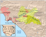
The Santa Ana River is the largest river of Southern
California
in the United States
. Its drainage basin
spans four counties. It rises in the San Bernardino Mountains
and flows past the cities of San Bernardino
and Riverside
, before cutting through the northern tip of the Santa Ana Mountains
and flowing southwest past Santa Ana
to spill into the Pacific Ocean
. The Santa Ana River is 96 miles (154.5 km) long, and drains a watershed of 2650 square miles (6,863.5 km²).
For its size the Santa Ana drainage basin is quite diverse. It ranges from high peaks of inland mountains in the north and east, to the hot, dry interior and semi-desert basin, to flat coastal plains in the west. Its climates range from dry alpine
to chaparral
and desert
, and the watershed as a whole is very arid. Relatively little water actually flows in the river or most of its tributaries
. One of its largest tributaries, the San Jacinto River
, rarely reaches the Santa Ana except in extremely wet years. The relative lack of vegetation also makes the river prone to flash flood
ing. Even so, a wide variety of animal and plant life has always been dependent on the river.
People have lived on the Santa Ana River for at least 9,000 years. There were four distinct indigenous groups in the area, all of which depended heavily on the river for their livelihoods. The river was first explored by Europeans in 1769, and received its name from Spanish
mission
fathers in the 19th century. Because it is one of the largest water sources in the four-county region, many large ranchos
developed alongside the river and one of its major tributaries, Santiago Creek
. This period of growth culminated in the establishment of many large cities on the river, including Santa Ana and Riverside, both of which derived their names from the River. In the early 20th century, devastating flood
s poured down the Santa Ana River, leading to much of the river being channelized and dam
med in recent times.
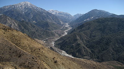 The Santa Ana River rises in Santa Ana Canyon in the southern San Bernardino Mountains
, at the confluence of two tiny streams, Heart Bar Creek and Coon Creek, at an elevation of 6991 feet (2,130.9 m). Its highest sources are Dollar Lake, at 9288 feet (2,831 m), and Dry Lake, at 9068 feet (2,763.9 m), both on the northern flank of San Gorgonio Mountain
, at the headwaters of a small left tributary, the South Fork Santa Ana River. The river initially flows west through this broad and deep gorge, and about 18 miles (29 km) from its headwaters, receives its first major tributary from the right: Bear Creek
, flowing southwest from well-known Big Bear Lake
. The river turns south, passing through the Seven Oaks Dam
, flowing out of its canyon into the arid interior basin of San Bernardino County
and Riverside County
, and receives Mill Creek
from the left as it winds westwards towards the city of San Bernardino
. As it passes through the urban area, it receives City Creek
from the right and enters a flood control channel
flanked by earthen levee
s on both sides.
Not long after the confluence with City Creek, Lytle Creek enters from the right. Lytle Creek is one of the largest tributaries of the Santa Ana river, rising in three forks in the San Gabriel Mountains and flowing southeast, becoming the Lytle Creek Wash before discharging into the main stem. From there, the Santa Ana flows southwest, and after passing through the city of Riverside
, it discharges into the normally dry flood control reservoir formed by Prado Dam
. Two major tributaries of the river join in the reservoir area: Chino Creek
from the right, and Temescal Creek from the left. Temescal Creek drains the largest area of all the tributaries, because it provides the outflow from Lake Elsinore
, into which the San Jacinto River
flows. It is also one of the longest, at 32 miles (51.5 km) in length. Except during the wettest years, Temescal Creek contains little or no water because Lake Elsinore is not high enough to overflow.
After flowing out of the Prado Dam, the Santa Ana River cuts a second Santa Ana Canyon
, a water gap
, between the northern Santa Ana Mountains and the Puente Hills
and Chino Hills
, crossing into Orange County
. The river roughly bisects the county as it flows southwest towards the ocean. The river is then entirely diverted into spreading grounds for groundwater recharge of the aquifer
of north Orange County, providing about half of the entire county’s municipal water. Downstream of there, the river serves only for flood control and waste drainage purposes, and typically has no more than a trickle of water. Passing the cities of Orange
and Tustin
, it receives Santiago Creek
from the left as it enters the city of Anaheim
. Here, the river is entirely confined to a concrete flood control channel between earthen levees. After crossing under Interstate 5
near Santa Ana
the riverbed again becomes earthen as it flows to its mouth between Huntington Beach
and Newport Beach
. The river accretes in a small lagoon
before flowing out to sea at the northern end of Santa Ana River County Beach.
and the coastal plain of north-central Orange County, and is bisected by the Santa Ana Mountains, which run nearly perpendicular to the river—northwest to southeast. There are over 50 major tributaries to the once free flowing and perennial river. The Temescal Creek valley constitutes a major portion and physiographic feature of the Santa Ana River watershed. The area drained by Temescal Creek and the San Jacinto River
constitute some 45% of the watershed and extend its boundaries as far south as the Anza-Borrego State Park area.
About 4.8 million people lived in the Santa Ana River basin as of 2000. Most of the population is concentrated close to the river in urban centers such as San Bernardino, Riverside, and Santa Ana. In the Inland Empire, most people live in a thin ribbon of land along the river, while the rest of the land is used for agriculture
and ranching. In Orange County, however, nearly all the land is urban. As a result, the Santa Ana River watershed can be thought of as having two distinct parts, separated by the Santa Ana Mountains. Some major bodies of water in the watershed include Lake Elsinore
, Lake Irvine
, Lake Mathews
, Lake Perris
, Diamond Valley Lake
, Lake Skinner
, and Big Bear Lake
. Only one, Lake Elsinore, is naturally formed. The rest are all formed by dams constructed by county or state water agencies. As an example, Diamond Valley Lake is for the California State Water Project
.
Several major Southern California drainage basins border on that of the Santa Ana River. In the northwest is the San Gabriel River
, another major river with its mouth in Long Beach
. On the southwest, the San Diego Creek
watershed forms much of the boundary within Orange County. Some of the rivers and streams that drain the area between the southwestern boundary of the watershed and the Pacific Ocean are Aliso Creek, San Juan Creek
, San Mateo Creek
, the Santa Margarita River
, and the San Luis Rey River
. On the east are the drainage basins of the Whitewater River
and the Coachella Valley
, flowing into the Salton Sea
, and on the north is the Mojave River
, which flows into the endorheic basin of the Mojave Desert
.
However, the area that the river drains in Orange County downstream of Santiago Creek is extremely narrow, because of the diversion of its former Orange County drainage area to the Talbert and Huntington Beach flood control channels, which empty into the Pacific very near the mouth of the Santa Ana. Most of the Santa Ana through Orange County now functions as a conduit to carry runoff from upstream areas directly to the Pacific and drains very little area downstream of the Santiago Creek confluence. About 21.4 square miles (55.4 km²) of land that originally drained to the Santa Ana River in Orange County now is drained by the two flood control channels, colloquially called the "Talbert watershed". The river originally had many different outlets to the Pacific, one of which even extended as far north as the San Gabriel River or as far south as Newport Harbor
. In fact, the original mouth of the river which drained eventually into the Pacific Ocean, was located at what is today the entrance to Newport harbor. Based on a U.S. Coastal Survey from 1878, Newport Bay was predominantly a river estuary with few open channels. The river flowed into the bay bringing with it heavy silt and making boating difficult. To eventually create Newport Harbor, sand that was deposited by the Santa Ana River had to be kept from choking the bay. In 1920, the Bitter Point Dam was built to divert the river away from the bay and on its current course to the ocean at Huntington Beach. Stone jetties were built to form the new river mouth. All of the Islands in Newport Harbor are the product of dredging and man made forming from the sands and silt deposited over time by the Santa Ana River.
, metamorphic
and sedimentary rock
underlie and form the geologic base of the Santa Ana River. Most of the strata
in the flat valleys and basins of the watershed are underlain by thousands of feet of sediment deposited by transient seas during climate changes and by erosion
. Most of the mountains in and rimming the basin consist of granite
batholith
s only about 75 million years old. However, much of the rock overlying the highlands, above elevations of 8000 to 9000 ft (2,438.4 to 2,743.2 m), is ancient metamorphic rock up to 1.7 billion years old. This rock originally formed at the bottom of the ancient Pacific Ocean and was uplifted to the highest peaks of the mountains. Even in ice age
s, glacier
s have rarely occurred on Southern California mountains, so the rock has remained there for tens of millions of years without significant erosion.
Diverse and complex faulting and geologic instability have shaped the Santa Ana River watershed. The San Andreas Fault
runs across the northern section of the watershed and was responsible for causing the uplift of the San Bernardino Mountains, part of the Transverse Ranges
of Southern California. The Elsinore
-Whittier Fault
Zone crosses the Santa Ana River further downstream, near the Orange County/Riverside County line. This fault caused the rising of the Santa Ana Mountains, Puente Hills, East Orange Hills, Chino Hills, Loma Ridge, and the other mountain ranges and ridges that run northwest-southeast across the lower section of the watershed, comprising the coastal Peninsular Ranges
. While the larger San Andreas Fault allowed the Transverse Ranges to rise to above 10000 feet (3,048 m) in many places, the Peninsular Ranges are only about half that height.
During the last glacial period, when climate change during the Wisconsinian Glaciation caused rivers in Southern California to increase greatly in volume, the Santa Ana was able to cut across the Peninsular Ranges, creating the only gap across the range. During this period, the Santa Ana changed course multiple times, creating wind gaps in the Peninsular Range and occasionally entrenching into the channel of the ancestral San Diego Creek
. The river later returned to its old course and abandoned the San Diego Creek channel, leaving it a wind gap across the Huntington Beach/Newport Beach mesa
.
 Hundreds of species of animals and plants characterize the Santa Ana River's diversity of climates and vegetation zones. There are over ten of these vegetation zones in the watershed—including the sparsely vegetated alpine
and subalpine zones in the mountains, mid-elevation forest
s of pine
, lodgepole
and oak
, chaparral
, coastal sage scrub
, the increasingly rare riparian forest
and marsh
es along the river bed, lined with trees and rushes, and the thinly vegetated coastal areas virtually flush with sea level
. The watershed supports up to 200 bird
species, fifty mammal
species, 13 reptile
species, 7 amphibian
species, and 15 fish
species, including steelhead trout.
The largest portion of the watershed, the Inland Empire portion, is dominated by a hot, dry desert
climate that supports little wildlife, while the climate and vegetation of the San Jacinto River
and Temescal Creek watershed is similar to that of the southern Central Valley. Downstream of the desert was once the coastal sage scrub
and dry grassland
community of the Orange County coastal plain, but that region has been almost entirely lost to urbanization. Rimming the arid portions of the watershed are the chaparral
zones, consisting of sclerophyll
ous, thick, low bushes and small trees. The chaparral generally is found between elevations of 1000 feet (304.8 m) and 6500 feet (1,981.2 m), and occurs mainly closer to the coast on the windward side of the Peninsular Ranges. The scrub oak
is one of the most common plants in chaparral regions, forming a dense groundcover that makes it difficult for humans and large animals such as mountain lions, coyote
s, and bobcat
s to traverse. Chaparral growth is determined by wildfire
s and droughts, and depends on the semi-arid climate of the region.
Perennial and seasonal streams often are lined with live oak
and sycamore
, which transition into the riparian zones of the main stem Santa Ana River. The inland riparian marshes upstream of the Riverside/Orange County line, although degraded by pollution, have otherwise been mostly left in their natural state. Although much of the riparian system along the river has been degraded, one of the largest places where it occurs is the enormous marsh behind Prado Dam
, an area closed to development because it functions as a flood control basin, similar to the Sepulveda Dam
. The Santa Ana sucker
, a small bottom-dwelling fish, once was found throughout riparian zones, but now is rarely seen in the Santa Ana River drainage. Near the mouth, the river was once abundant in salt marsh
es, which stretched for miles on either side of the river, even near Upper Newport Bay
, which has also served as an alternate mouth of the river.
The alpine and subalpine zones, despite their high elevation (above 9500 feet, 2900 meters) and significant rainfall (up to 35 inches, 89 cm per year), are sparsely vegetated. The windswept terrain of the alpine zone is primarily small brush and weeds, while trees—mostly small gnarled pine
s and juniper
s—occur in canyons and shielded depressions in the subalpine zone. Inland elevations above 5000 feet (1,524 m) support much denser forest. Jeffrey pine
, ponderosa pine
, black oak, lodgepole pine
, and willow constitute most of the forested lands. The mountain habitats of the watershed support many animals typical of Californian mountain regions, including squirrel
s, chipmunk
s, black bear
s, mule deer
, and many species of migratory birds. In the canyons of the San Bernardinos, the river is abundant in landlocked rainbow trout
and is lined with alder
s, willow and cottonwoods. Where the river and its large upper tributaries empty out of the mountain canyons into the Inland Empire basin, they are surrounded by the alluvial scrub zone, a mix of desert and upper riparian vegetation. Along the main stem, this zone begins at the base of Seven Oaks Dam
and ends at the Lytle Creek confluence.
Historically, the Santa Ana was named "the best stream in Southern California [for steelhead trout habitat]". The steelhead is an anadromous fish, similar to salmon
, that migrates up rivers and streams to spawn. Unlike salmon, which usually only reproduce once, steelhead may reproduce multiple times and have a much longer life span. Steelhead was once found along the entire main stem of the Santa Ana River, as well as on some of its main tributaries—Santiago Creek
, San Antonio and Chino Creeks, Cucamonga Creek, Lytle Creek, City Creek, and Mill Creek
. Few, if any, steelhead were present in Temescal Creek (although one of its tributaries was stocked in the 1930s) and none inhabited the San Jacinto River
, because it is disconnected from most of the Santa Ana River system. Up to the 1950s, significant numbers of steelhead trout still migrated in from the ocean. Because of pollution and modifications to the river, very few steelhead still use the river. The exception is the presence of landlocked rainbow trout—the freshwater phase of steelhead—upstream of Seven Oaks Dam and in the upper reaches of a few tributaries. Despite the rarity of steelhead, in recent years fin samples from 13 trout were collected from Harding Canyon in the Santiago Creek
tributary of the Santa Ana River and genetic analysis has shown them to be of native and not hatchery stocks.
Invasive species—those that are not native to the region—have caused problems in the watershed for many years. One of the most troublesome invasive species is the giant reed, which plagues many coastal Southern California waterways. The giant reed is similar to a tall grass or thin bamboo
, but grows quickly and can take over native stands of vegetation, block the streambed, hurts the habitat of native animals, and increases the hazard of wildfire
s. Perhaps the largest effect that giant reed has is its usage of water. To supplement its fast growth growth rate, the giant reed population in the Santa Ana River watershed can consume 56200 acre.ft of water per year.
Other invasive species also have affected the Santa Ana River. One of the most prominent is the brown-headed cowbird
, which feeds off parasites and insects identified with cattle
, which were brought to Southern California during the Spanish Rancho period. The brown-headed cowbird is a "brood parasite", or a bird that lays its eggs in another bird's nest. One of the most afflicted birds is the Least Bell's Vireo, whose population also suffers from the loss of riparian habitat. The Least Bell's Vireo is considered an endangered species, as is the southwestern willow flycatcher
, whose habitat is often shared with the other bird. The saltcedar is another invasive large weed that also, like the giant reed, uses large amounts of water. Unlike giant reed, the saltcedar has deeper roots, not only making it more difficult to remove but allowing it to access and use up deep groundwater
. However, the saltcedar is similar in that it also provides little usable habitat for native animals.
period. The first Native Americans to live in the area were nomad
ic tribes that traveled from place to place, grazing animals on fertile grasslands and gathering fruits and seeds for food. The ancestors of these early people originated from the Shoshone
and Uto-Aztecan people of the northwestern United States. Eventually, the human population of the watershed reached a peak of about 15,000. About 8,000 years ago, the climate experienced a change becoming more arid and the originally nomadic tribes began to stay in individual places longer, becoming semi-nomadic. However, they did not establish agriculture
, nor did they raise animals or live in villages. Like many Native American tribes in California, acorn
s were a staple food of many of the inland valley people. People closer to the ocean often fished and hunted small animals, often from tide pool
s and coastal stream areas, for food.
Several major premodern Native American groups eventually gained control of lands along the river: the Yuhaviatam
or Yuharetum people in the upper basin, the Payomkowishum in the southeastern basin, the Cahuilla in the desert areas of the watershed, and the Tongva people in the lower basin. The Yuhaviatum generally lived in the mountain headwaters of the Santa Ana River and its tributaries rimming the present-day Inland Empire basin, in present-day San Bernardino County, as well as in the foothills
of the San Bernardino Mountains. The Tongva lived on the flat coastal plain
s of present-day Orange County south of the Santa Ana Mountains. They were also the larger of the two groups, controlling all the coastal lands from the San Gabriel Mountains
in the north to Aliso Creek in the south, including all of the Los Angeles Basin
.
 When Spanish
explorer Juan Rodriguez Cabrillo
sailed along the Southern California coast on a voyage to the Channel Islands
in 1542, he passed the mouth of the Santa Ana River. Over 200 years later in 1769, Gaspar de Portola
led an overland expedition northwards through coastal Southern California — now an overseas territory of Spain
— and gave the river its name. On Saint Anne's Day
, July 26, 1769, his party camped near where the Santa Ana River empties from the canyon through the northern Santa Ana Mountains. They named the valley for Saint Anne, and the name of the mountain range and the river derives from there. Fray Juan Crespi
, one of the members of the expedition, stated that the river was named El Rio del Dulcissimo de Jesus de los Temblores, referring to an earthquake
that struck when they were camped alongside its banks. The river was soon renamed Rio de Santa Anna — River of Saint Anne — a name that remains today.
Although no missions were actually located along the Santa Ana River or within the watershed, the river basin was nearly depleted of native people because the Spanish forced them to work at nearby missions, including Mission San Gabriel Arcangel
and Mission San Luis Rey. The affected tribes were usually renamed after the missions, resulting in tribal names such as Gabrieliño and Luiseño. Difficult working and living conditions and European diseases such as smallpox
killed much of the native population during the roughly 50-year-long Mission Period. The Secularization Act of 1833, passed by the newly independent country of Mexico
, eventually brought an end to the Mission Period. The post-Mission Period native population was almost entirely devastated. The population was very little, their native religions were nearly lost, and most of their land had been taken by Spanish settlers. Although the Mexican government's original intention with the Secularization Act was to provide the Native Americans with their own land and property, most of the provisions made by the act never actually happened. Spanish settlers continued to press into the remaining tribal lands, and eventually, the tribes were forced into the surrounding desert lands or into the high mountains.
Following the Mission Period came the Rancho Period
. This occurred when the enormous land holdings of the missions were subdivided into ranchos
owned by wealthy individuals. The first of these ranchos along the Santa Ana River was Rancho Santiago de Santa Ana
, a 62500 acres (252.9 km²) rancho on the left bank of the lower Santa Ana River. This rancho was acquired by Don Juan Pablo Grijalva as early as 1801. Other ranchos on the river followed, including ones in inland areas that had not been exploited in the Mission Period. The establishments of the ranchos began the tradition of raising cattle
in coastal Southern California, a custom upheld until the late 19th century. Agriculture, however, although established, was not yet a major industry. A flood that raged down the Santa Ana in 1825 caused the river's course to change temporarily to an outlet at Newport Bay
, depositing sediment that partially created Balboa Island. Spread throughout the ranchos on the Santa Ana River were a few towns, military outposts and trading posts. The Santa Ana River valley was one of the most prosperous regions in Southern California for many decades.
area. However, the Santa Ana River flooded, preventing the Mexicans from crossing the river to attack the Americans. When the river's flow finally subsided, the Americans prepared themselves enough to drive the Mexicans out of the region.
When the California Republic
was assimilated into the United States in 1848, American settlers began to move into the Santa Ana River region in great numbers. The Mexican ranchos were divided into smaller individual properties, and irrigated agriculture began on a large scale. The city of Santa Ana
Viejo, the original location of Santa Ana, was founded in this period. In 1854, Mormon
s settled in the upper Inland Empire area and started the city of San Bernardino
, gaining prosperity by using water from the river, as well as Lytle Creek and Mill Creek
, to irrigate crops. The cattle industry began to decline as farms began to replace ranches. Soon, white settlers in the region were more numerous than Hispanics as well. The California Gold Rush
around this time was responsible for attracting many of these people to the state, but many remained in Southern California afterwards.
In 1860, a much closer gold rush occurred in the San Bernardino Mountains when prospector William Holcomb discovered significant deposits, just over the northern drainage divide of the Santa Ana River. This discovery exploded into a full-scale gold mining operation in days. The Santa Ana River served as a conduit for miners traveling to the region and many of the forests in the upper basin experienced clearcutting
as a result of the high resource demands of the boom. Gold was also discovered in Lytle Creek in that same year. Following the gold rush, the cultivation of citrus
became the mainstay of the economy of the lower Santa Ana River area. Through the late 19th century, citrus fields covered much of the coastal plain and led to the naming of Orange County.
, heavy rains dropped by a series of hurricanes caused the Santa Ana to burst its banks, flooding thousands of acres of land and killing 20 to 40 people in the greatest flood
it had experienced in recorded history. The levee
s along the river burst in many places, flooding part of the Inland Empire into a continuous body of water several miles wide stretching from the mouth of Santa Ana Canyon to where the river cuts through the Santa Ana Mountains. Downstream in Orange County, the river overwhelmed nearly all the existing floodworks and transformed the coastal plain into a transient inland sea. The flow, now calculated as a 1,000-year flood, peaked at roughly 9000 m3/s, over half the average flow of the Mississippi River
. Even after the flood, detrimental conditions continued in the region. For the two years following the flood, an intense drought
caused the deaths of tens of thousands of head of livestock. Despite all of the hardships experienced in the three years, after conditions finally returned to normal, the Santa Ana River watershed again became a prospering agricultural region. The cities of Santa Ana
and Riverside
were established in 1869 and 1870, respectively.
1934 and 1938 saw a further pair of devastating floods that in part brought an end to the area's citrus industry. In 1938, the Santa Ana again burst its banks and flooded Anaheim
and Orange
in up to 4 feet (1.2 m) of water, stripping away thousands of acres of rich topsoil and destroying many of the citrus groves. Almost 60 people were killed in the disaster and about 68400 acres (276.8 km²) of land were flooded, despite the fact that the flow in the river was only one-third of that of the 1862 flood. With the extreme damage from the floods, the U.S. Army Corps of Engineers made the decision to dam and concrete the river beginning in the 1940s, and declared it as the greatest flood hazard in the U.S. west of the Mississippi River
. Prado Dam
, built in 1941, was designed to capture floodwaters from the Inland Empire about 30 miles (48.3 km) upstream from the river's mouth. The dam's impoundment, Prado Flood Control Basin, was designed to handle a 70-year flood.
With the increased flood protection afforded by the Prado Dam, major industrial development migrating south from the Los Angeles Basin, and the Southern California housing boom in the 1950s and 1960s, the Santa Ana River watershed began its third and final transition—from agricultural to urban
. The population of the Santa Ana River basin increased dramatically, but brought with it the threat of greater damage from floods, somewhat compromising the protection afforded by Prado Dam. Because housing and urban areas encroached on the river's historic floodplain
—an area once occupied by farms—and the river became confined to a narrow channel—a flood similar to the ones surrounding the turn of the 20th century would cause much more damage. The construction of roads and buildings also heightened the runoff that would flow into the river during rainfall, a process known as urban runoff
. In fact, the river flooded again in 1969, and while much of the runoff from the Inland Empire was captured behind Prado Dam—probably saving Orange County from an even greater flood—Santiago Creek, a large tributary flowing from the Santa Ana Mountains, eroded its banks until it swept away portions of residential communities in the cities of Tustin
and Orange
.
In 1964, the Santa Ana River Mainstem Project, which involved concreting the lower 30.4 miles (48.9 km) of the river, was first proposed. Construction work began in 1989, and today, through much of Orange County, the river's channel is essentially an enormous box culvert
. The second dam, Seven Oaks Dam, was completed in 1999. This dam captures flood runoff from Santa Ana Canyon before it can enter the Inland Empire. The dam was designed to withstand a 350-year flood. Today, the river lies mainly between levees and concrete channels, and especially in its lower course, functions only as a flood drainage channel.
is free flowing, as are many of its upper tributaries. Once the river enters the Inland Empire basin, however, much of its flow is diverted for municipal and agricultural water use. Most of the flow in the river below the city of San Bernardino consists of effluent from 45 wastewater treatment plants
and dry season urban runoff
, which is collected behind Prado Dam
. Any flow that makes it downstream to Orange County is diverted by another pair of dams into approximately 1100 acres (4.5 km²) of groundwater
recharge basins, providing approximately 218000 acre.ft of municipal water for the county every year, or one-third of its water supply. Downstream of that dam, the river gathers further urban runoff before finally making it into the Pacific. The Santa Ana River is included on the U.S. Environmental Protection Agency's (EPA) list of "304 (l) 'toxic hot spots' list of impaired waterways."
A number of organizations have been formed to try and gain public interest in restoring the river. One of the most prominent is the Santa Ana Watershed Project Authority (SAWPA), formed by five municipal water districts in the Santa Ana River area. A second one is the Santa Ana River Dischargers Association. Both have conducted studies as to what beneficial uses the Santa Ana River would have aside from water supply and flood control, as well as the removal of some of the concreted sections of the lower river. This set of studies is known as the "Use-Attainability Analysis", which was submitted to the state Congress, which approved it. However, upon submission to the EPA, it was rejected. As a result, little work has been done to repair the ecological damage that has been caused by urbanization along the river. Other projects include the Santa Ana Watershed Planning Advisory Committee, and the Santa Ana River Watershed Alliance (SARWA).
which, when complete, will run from the river's mouth at Huntington Beach to near the San Bernardino Mountains, currently extends about 30 miles (48.3 km) along the river to Prado Dam. The proposed distance along the trail is over 70 miles (112.7 km). In Riverside County, the Hidden Valley Wildlife Area also has 25 miles (40.2 km) of recreational paths. The Santa Ana River watershed includes parts of the Cleveland National Forest
, San Bernardino National Forest
, Angeles National Forest
, Mount San Jacinto State Wilderness Area
, Chino Hills State Park
, and Lake Perris State Recreation Area. Some entities have been opting for a Santa Ana River Park, which would encompass a strip of land on either side of the river for its entire course. Big Bear Lake
, Lake Elsinore
, and Lake Irvine
are popular recreational lakes in the watershed. The river never actually flows through any of these lakes, but they each have drainage to the river via tributaries. The Santa Ana River Lakes, located near Anaheim, are a popular recreational fish farm
fed with water from the river.
Southern California
Southern California is a megaregion, or megapolitan area, in the southern area of the U.S. state of California. Large urban areas include Greater Los Angeles and Greater San Diego. The urban area stretches along the coast from Ventura through the Southland and Inland Empire to San Diego...
California
California
California is a state located on the West Coast of the United States. It is by far the most populous U.S. state, and the third-largest by land area...
in the United States
United States
The United States of America is a federal constitutional republic comprising fifty states and a federal district...
. Its drainage basin
Drainage basin
A drainage basin is an extent or an area of land where surface water from rain and melting snow or ice converges to a single point, usually the exit of the basin, where the waters join another waterbody, such as a river, lake, reservoir, estuary, wetland, sea, or ocean...
spans four counties. It rises in the San Bernardino Mountains
San Bernardino Mountains
The San Bernardino Mountains are a short transverse mountain range north and east of San Bernardino in Southern California in the United States. The mountains run for approximately 60 miles east-west on the southern edge of the Mojave Desert in southwestern San Bernardino County, north of the...
and flows past the cities of San Bernardino
San Bernardino, California
San Bernardino is a city located in the Riverside-San Bernardino metropolitan area , and serves as the county seat of San Bernardino County, California, United States...
and Riverside
Riverside, California
Riverside is a city in Riverside County, California, United States, and the county seat of the eponymous county. Named for its location beside the Santa Ana River, it is the largest city in the Riverside-San Bernardino-Ontario metropolitan area of Southern California, 4th largest inland California...
, before cutting through the northern tip of the Santa Ana Mountains
Santa Ana Mountains
The Santa Ana Mountains are a short peninsular mountain range along the coast of Southern California in the United States. They extend for approximately 36 mi southeast of the Los Angeles Basin largely along the border between Orange and Riverside counties.- Geography :The range starts in the...
and flowing southwest past Santa Ana
Santa Ana, California
Santa Ana is the county seat and second most populous city in Orange County, California, and with a population of 324,528 at the 2010 census, Santa Ana is the 57th-most populous city in the United States....
to spill into the Pacific Ocean
Pacific Ocean
The Pacific Ocean is the largest of the Earth's oceanic divisions. It extends from the Arctic in the north to the Southern Ocean in the south, bounded by Asia and Australia in the west, and the Americas in the east.At 165.2 million square kilometres in area, this largest division of the World...
. The Santa Ana River is 96 miles (154.5 km) long, and drains a watershed of 2650 square miles (6,863.5 km²).
For its size the Santa Ana drainage basin is quite diverse. It ranges from high peaks of inland mountains in the north and east, to the hot, dry interior and semi-desert basin, to flat coastal plains in the west. Its climates range from dry alpine
Alpine climate
Alpine climate is the average weather for a region above the tree line. This climate is also referred to as mountain climate or highland climate....
to chaparral
Chaparral
Chaparral is a shrubland or heathland plant community found primarily in the U.S. state of California and in the northern portion of the Baja California peninsula, Mexico...
and desert
Desert
A desert is a landscape or region that receives an extremely low amount of precipitation, less than enough to support growth of most plants. Most deserts have an average annual precipitation of less than...
, and the watershed as a whole is very arid. Relatively little water actually flows in the river or most of its tributaries
Tributary
A tributary or affluent is a stream or river that flows into a main stem river or a lake. A tributary does not flow directly into a sea or ocean...
. One of its largest tributaries, the San Jacinto River
San Jacinto River (California)
The San Jacinto River is a river in Riverside County, California. The river's headwaters are in San Bernardino National Forest, but the lower portion of the watershed is urban and agricultural land....
, rarely reaches the Santa Ana except in extremely wet years. The relative lack of vegetation also makes the river prone to flash flood
Flash flood
A flash flood is a rapid flooding of geomorphic low-lying areas—washes, rivers, dry lakes and basins. It may be caused by heavy rain associated with a storm, hurricane, or tropical storm or meltwater from ice or snow flowing over ice sheets or snowfields...
ing. Even so, a wide variety of animal and plant life has always been dependent on the river.
People have lived on the Santa Ana River for at least 9,000 years. There were four distinct indigenous groups in the area, all of which depended heavily on the river for their livelihoods. The river was first explored by Europeans in 1769, and received its name from Spanish
Spanish people
The Spanish are citizens of the Kingdom of Spain. Within Spain, there are also a number of vigorous nationalisms and regionalisms, reflecting the country's complex history....
mission
Mission (Christian)
Christian missionary activities often involve sending individuals and groups , to foreign countries and to places in their own homeland. This has frequently involved not only evangelization , but also humanitarian work, especially among the poor and disadvantaged...
fathers in the 19th century. Because it is one of the largest water sources in the four-county region, many large ranchos
Ranchos of California
The Spanish, and later the Méxican government encouraged settlement of territory now known as California by the establishment of large land grants called ranchos, from which the English ranch is derived. Devoted to raising cattle and sheep, the owners of the ranchos attempted to pattern themselves...
developed alongside the river and one of its major tributaries, Santiago Creek
Santiago Creek
Santiago Creek is a major watercourse in Orange County in the U.S. state of California. About long, it drains most of the northern Santa Ana Mountains and is a tributary to the Santa Ana River...
. This period of growth culminated in the establishment of many large cities on the river, including Santa Ana and Riverside, both of which derived their names from the River. In the early 20th century, devastating flood
Flood
A flood is an overflow of an expanse of water that submerges land. The EU Floods directive defines a flood as a temporary covering by water of land not normally covered by water...
s poured down the Santa Ana River, leading to much of the river being channelized and dam
Dam
A dam is a barrier that impounds water or underground streams. Dams generally serve the primary purpose of retaining water, while other structures such as floodgates or levees are used to manage or prevent water flow into specific land regions. Hydropower and pumped-storage hydroelectricity are...
med in recent times.
Course
San Bernardino Mountains
The San Bernardino Mountains are a short transverse mountain range north and east of San Bernardino in Southern California in the United States. The mountains run for approximately 60 miles east-west on the southern edge of the Mojave Desert in southwestern San Bernardino County, north of the...
, at the confluence of two tiny streams, Heart Bar Creek and Coon Creek, at an elevation of 6991 feet (2,130.9 m). Its highest sources are Dollar Lake, at 9288 feet (2,831 m), and Dry Lake, at 9068 feet (2,763.9 m), both on the northern flank of San Gorgonio Mountain
San Gorgonio Mountain
San Gorgonio Mountain, also known locally as Mount San Gorgonio, or Old Greyback, is the highest peak in Southern California at . It is in the San Bernardino Mountains, east of the city of San Bernardino and north-northeast of San Gorgonio Pass. It lies within the San Gorgonio Wilderness, part of...
, at the headwaters of a small left tributary, the South Fork Santa Ana River. The river initially flows west through this broad and deep gorge, and about 18 miles (29 km) from its headwaters, receives its first major tributary from the right: Bear Creek
Bear Creek (Santa Ana River)
Bear Creek is an approximately tributary of the Santa Ana River in the San Bernardino Mountains of the U.S. state of California. Its length is entirely contained within San Bernardino County. It rises near Woodlands and flows north into Baldwin Lake...
, flowing southwest from well-known Big Bear Lake
Big Bear Lake
Big Bear Lake is a reservoir in the San Bernardino Mountains, in San Bernardino County, California, United States. At a surface elevation of , it has an east-west length of approximately 7 miles and is approximately 2.5 miles at its widest measurement, though the lake's width mostly averages a...
. The river turns south, passing through the Seven Oaks Dam
Seven Oaks Dam
The Seven Oaks Dam is located on the Santa Ana River, 4 miles northeast of Redlands, California. It was constructed by the United States Army Corps of Engineers as a flood control dam. The dam sits virtually on top of the San Andreas Fault and is designed to withstand a magnitude 8.0...
, flowing out of its canyon into the arid interior basin of San Bernardino County
San Bernardino County, California
San Bernardino County is a county in the U.S. state of California. As of the 2010 census, the population was 2,035,210, up from 1,709,434 as of the 2000 census...
and Riverside County
Riverside County, California
Riverside County is a county in the U.S. state of California. One of 58 California counties, it covers in the southern part of the state, and stretches from Orange County to the Colorado River, which forms the state border with Arizona. The county derives its name from the city of Riverside,...
, and receives Mill Creek
Mill Creek (Southern California)
Mill Creek is a stream, originating in the San Bernardino Mountains, in San Bernardino County, California. It is a major tributary of the Santa Ana River. Their confluence occurs just downstream of the upper Santa Ana Canyon mouth...
from the left as it winds westwards towards the city of San Bernardino
San Bernardino, California
San Bernardino is a city located in the Riverside-San Bernardino metropolitan area , and serves as the county seat of San Bernardino County, California, United States...
. As it passes through the urban area, it receives City Creek
City Creek (California)
City Creek is a tributary of the Santa Ana River in western San Bernardino County in the U.S. state of California. Its watershed drains about on the southwest slopes of the San Bernardino Mountains...
from the right and enters a flood control channel
Flood control channel
Flood control channels are a series of large and empty open-air channels that extend a ways below the street levels of some larger cities, so that if and when a flood occurs, the flood will run into the channels, and proceed to be drained to the proper body of water...
flanked by earthen levee
Levee
A levee, levée, dike , embankment, floodbank or stopbank is an elongated naturally occurring ridge or artificially constructed fill or wall, which regulates water levels...
s on both sides.
Not long after the confluence with City Creek, Lytle Creek enters from the right. Lytle Creek is one of the largest tributaries of the Santa Ana river, rising in three forks in the San Gabriel Mountains and flowing southeast, becoming the Lytle Creek Wash before discharging into the main stem. From there, the Santa Ana flows southwest, and after passing through the city of Riverside
Riverside, California
Riverside is a city in Riverside County, California, United States, and the county seat of the eponymous county. Named for its location beside the Santa Ana River, it is the largest city in the Riverside-San Bernardino-Ontario metropolitan area of Southern California, 4th largest inland California...
, it discharges into the normally dry flood control reservoir formed by Prado Dam
Prado Dam
Prado Dam is an earth-fill dam across the Santa Ana River at the Chino Hills near Corona, California in Riverside County with the resulting impounded water creating Prado Flood Control Basin reservoir. The U.S. Army Corps of Engineers built the dam in Lower Santa Ana River Canyon...
. Two major tributaries of the river join in the reservoir area: Chino Creek
Chino Creek
Chino Creek is a major stream of the Inland Empire in Southern California in the United States. Although the main stem is short at about , it drains an extensive basin of from the San Gabriel Mountains to the Santa Ana River near Corona...
from the right, and Temescal Creek from the left. Temescal Creek drains the largest area of all the tributaries, because it provides the outflow from Lake Elsinore
Lake Elsinore
Lake Elsinore, originally named Laguna Grande by the Spanish explorers, renamed for the town Lake Elsinore, California established on its northeastern shore April 9, 1888.-Limnology:...
, into which the San Jacinto River
San Jacinto River (California)
The San Jacinto River is a river in Riverside County, California. The river's headwaters are in San Bernardino National Forest, but the lower portion of the watershed is urban and agricultural land....
flows. It is also one of the longest, at 32 miles (51.5 km) in length. Except during the wettest years, Temescal Creek contains little or no water because Lake Elsinore is not high enough to overflow.
After flowing out of the Prado Dam, the Santa Ana River cuts a second Santa Ana Canyon
Santa Ana Canyon
Santa Ana Canyon is where the Santa Ana River passes between the Santa Ana Mountains and the Chino Hills, near the intersection of Orange, Riverside, and San Bernardino Counties. It receives particularly strong Santa Ana winds in comparison to surrounding areas, hence the name.-History:Originally,...
, a water gap
Water gap
A water gap is an opening or notch which flowing water has carved through a mountain range. Water gaps often offer a practical route for road and rail transport to cross mountain ridges.- Geology :...
, between the northern Santa Ana Mountains and the Puente Hills
Puente Hills
The Puente Hills is a chain of hills, one of the lower Transverse Ranges, in an unincorporated area in eastern Los Angeles County, California.-Geography:...
and Chino Hills
Chino Hills
The Chino Hills are a mountain range on the border of Orange, Los Angeles, and San Bernardino Counties, California, with a small portion in Riverside County...
, crossing into Orange County
Orange County, California
Orange County is a county in the U.S. state of California. Its county seat is Santa Ana. As of the 2010 census, its population was 3,010,232, up from 2,846,293 at the 2000 census, making it the third most populous county in California, behind Los Angeles County and San Diego County...
. The river roughly bisects the county as it flows southwest towards the ocean. The river is then entirely diverted into spreading grounds for groundwater recharge of the aquifer
Aquifer
An aquifer is a wet underground layer of water-bearing permeable rock or unconsolidated materials from which groundwater can be usefully extracted using a water well. The study of water flow in aquifers and the characterization of aquifers is called hydrogeology...
of north Orange County, providing about half of the entire county’s municipal water. Downstream of there, the river serves only for flood control and waste drainage purposes, and typically has no more than a trickle of water. Passing the cities of Orange
Orange, California
Southern California is well-known for year-round pleasant weather: - On average, the warmest month is August. - The highest recorded temperature was in 1985. - On average, the coolest month is December. - The lowest recorded temperature was in 1950...
and Tustin
Tustin, California
-Top employers:According to the City's 2010 Comprehensive Annual Financial Report, the top employers in the city are:-2010:The 2010 United States Census reported that Tustin had a population of 75,540. The population density was 6,816.7 people per square mile...
, it receives Santiago Creek
Santiago Creek
Santiago Creek is a major watercourse in Orange County in the U.S. state of California. About long, it drains most of the northern Santa Ana Mountains and is a tributary to the Santa Ana River...
from the left as it enters the city of Anaheim
Anaheim, California
Anaheim is a city in Orange County, California. As of the 2010 United States Census, the city population was about 365,463, making it the most populated city in Orange County, the 10th most-populated city in California, and ranked 54th in the United States...
. Here, the river is entirely confined to a concrete flood control channel between earthen levees. After crossing under Interstate 5
Interstate 5
Interstate 5 is the main Interstate Highway on the West Coast of the United States, running largely parallel to the Pacific Ocean coastline from Canada to Mexico . It serves some of the largest cities on the U.S...
near Santa Ana
Santa Ana, California
Santa Ana is the county seat and second most populous city in Orange County, California, and with a population of 324,528 at the 2010 census, Santa Ana is the 57th-most populous city in the United States....
the riverbed again becomes earthen as it flows to its mouth between Huntington Beach
Huntington Beach, California
Huntington Beach is a seaside city in Orange County in Southern California. According to the 2010 census, the city population was 189,992; making it the largest beach city in Orange County in terms of population...
and Newport Beach
Newport Beach, California
Newport Beach, incorporated in 1906, is a city in Orange County, California, south of downtown Santa Ana. The population was 85,186 at the 2010 census.The city's median family income and property values consistently place high in national rankings...
. The river accretes in a small lagoon
Lagoon
A lagoon is a body of shallow sea water or brackish water separated from the sea by some form of barrier. The EU's habitat directive defines lagoons as "expanses of shallow coastal salt water, of varying salinity or water volume, wholly or partially separated from the sea by sand banks or shingle,...
before flowing out to sea at the northern end of Santa Ana River County Beach.
Watershed
One of the largest river basins in Southern California and the largest on the South Coast, the Santa Ana River watershed covers 2650 square miles (6,863.5 km²) in parts of four California counties. The main stem of the river flows through three of these counties, and tributaries drain parts of Los Angeles County into the Santa Ana. The watershed is characterized by the flat, arid basin of the Inland EmpireInland Empire (California)
The Inland Empire is a region in Southern California. The region sits directly east of the Los Angeles metropolitan area. The Inland Empire most commonly is used in reference to the U.S. Census Bureau's federally-defined Riverside-San Bernardino-Ontario metropolitan area, which covers more than...
and the coastal plain of north-central Orange County, and is bisected by the Santa Ana Mountains, which run nearly perpendicular to the river—northwest to southeast. There are over 50 major tributaries to the once free flowing and perennial river. The Temescal Creek valley constitutes a major portion and physiographic feature of the Santa Ana River watershed. The area drained by Temescal Creek and the San Jacinto River
San Jacinto River (California)
The San Jacinto River is a river in Riverside County, California. The river's headwaters are in San Bernardino National Forest, but the lower portion of the watershed is urban and agricultural land....
constitute some 45% of the watershed and extend its boundaries as far south as the Anza-Borrego State Park area.
About 4.8 million people lived in the Santa Ana River basin as of 2000. Most of the population is concentrated close to the river in urban centers such as San Bernardino, Riverside, and Santa Ana. In the Inland Empire, most people live in a thin ribbon of land along the river, while the rest of the land is used for agriculture
Agriculture
Agriculture is the cultivation of animals, plants, fungi and other life forms for food, fiber, and other products used to sustain life. Agriculture was the key implement in the rise of sedentary human civilization, whereby farming of domesticated species created food surpluses that nurtured the...
and ranching. In Orange County, however, nearly all the land is urban. As a result, the Santa Ana River watershed can be thought of as having two distinct parts, separated by the Santa Ana Mountains. Some major bodies of water in the watershed include Lake Elsinore
Lake Elsinore
Lake Elsinore, originally named Laguna Grande by the Spanish explorers, renamed for the town Lake Elsinore, California established on its northeastern shore April 9, 1888.-Limnology:...
, Lake Irvine
Lake Irvine
Lake Irvine is a reservoir in Orange County, California. The lake is on Santiago Creek, is located northeast of the city of Irvine close to Irvine Regional Park....
, Lake Mathews
Lake Mathews
Lake Mathews is a large reservoir in Riverside County, California, located in the foothills of the Santa Ana Mountains. It is the western terminus for the Colorado River Aqueduct that provides much of the water used by the cities and water districts of the Metropolitan Water District of Southern...
, Lake Perris
Lake Perris
Lake Perris is an artificial lake completed in 1973. It is the southern terminus of the California State Water Project situated in a mountain-rimmed valley between Moreno Valley, and city of Perris in what is now the Lake Perris State Recreation Area. The park offers a variety of recreational...
, Diamond Valley Lake
Diamond Valley Lake
The embankment required of crushed rock. An on-site crushing plant crushed and processed over 14 million tons of rock in 20 months to supply the dam's materials. The cut-off wall, which consists of a thick plastic concrete mix constructed through the weathered portion of bedrock, varies in depth...
, Lake Skinner
Lake Skinner
Lake Skinner is a large reservoir in western Riverside County, California, located at the foot of Bachelor Mountain in the Auld Valley, approximately 10 miles northeast of Temecula...
, and Big Bear Lake
Big Bear Lake
Big Bear Lake is a reservoir in the San Bernardino Mountains, in San Bernardino County, California, United States. At a surface elevation of , it has an east-west length of approximately 7 miles and is approximately 2.5 miles at its widest measurement, though the lake's width mostly averages a...
. Only one, Lake Elsinore, is naturally formed. The rest are all formed by dams constructed by county or state water agencies. As an example, Diamond Valley Lake is for the California State Water Project
California State Water Project
The California State Water Project, commonly known as the SWP , is the world's largest publicly built and operated water and power development and conveyance system. The SWP was designed and is operated by the California Department of Water Resources...
.
Several major Southern California drainage basins border on that of the Santa Ana River. In the northwest is the San Gabriel River
San Gabriel River (California)
The San Gabriel River flows through southern Los Angeles County, California in the United States. Its main stem is about long, while its farthest tributaries extend almost altogether...
, another major river with its mouth in Long Beach
Long Beach, California
Long Beach is a city situated in Los Angeles County in Southern California, on the Pacific coast of the United States. The city is the 36th-largest city in the nation and the seventh-largest in California. As of 2010, its population was 462,257...
. On the southwest, the San Diego Creek
San Diego Creek
San Diego Creek is a waterway flowing into Upper Newport Bay in central Orange County in the U.S. state of California. Its basin covers in parts of eight cities, including Irvine, Tustin, and Costa Mesa. The major tributary of the northeast-flowing stream is Peters Canyon Wash, which joins a few...
watershed forms much of the boundary within Orange County. Some of the rivers and streams that drain the area between the southwestern boundary of the watershed and the Pacific Ocean are Aliso Creek, San Juan Creek
San Juan Creek
San Juan Creek, also called the San Juan River, is a stream in Orange County, California that consists of a catchment basin encompassing . Its mainstem rises in the Santa Ana Mountains, in the Trabuco Ranger District of the Cleveland National Forest...
, San Mateo Creek
San Mateo Creek (Southern California)
San Mateo Creek is a stream in Southern California in the United States, whose watershed mostly straddles the border of Orange and San Diego Counties. It is about long, flowing in a generally southwesterly direction...
, the Santa Margarita River
Santa Margarita River
The Santa Margarita River is a short intermittent river on the Pacific coast of southern California in the United States, approximately long. One of the last free-flowing rivers in southern California, it drains an arid region of the Coast Ranges between Los Angeles and San Diego at the southern...
, and the San Luis Rey River
San Luis Rey River
The San Luis Rey River is a river in northern San Diego County, California. The river's headwaters are in the Cleveland National Forest near Palomar Mountain. The river drains into the Pacific Ocean on the northern end of the city of Oceanside. The river is over long and drains...
. On the east are the drainage basins of the Whitewater River
Whitewater River (California)
The Whitewater River is a small permanent stream in western Riverside County, California, except for a small upstream portion in southwestern San Bernardino County. Its headwaters are in the San Bernardino Mountains and 'mouth'—terminus in the Colorado Desert...
and the Coachella Valley
Coachella Valley
Coachella Valley is a large valley landform in Southern California. The valley extends for approximately 45 miles in Riverside County southeast from the San Bernardino Mountains to the saltwater Salton Sea, the largest lake in California...
, flowing into the Salton Sea
Salton Sea
The Salton Sea is a shallow, saline, endorheic rift lake located directly on the San Andreas Fault, predominantly in California's Imperial Valley. The lake occupies the lowest elevations of the Salton Sink in the Colorado Desert of Imperial and Riverside counties in Southern California. Like Death...
, and on the north is the Mojave River
Mojave River
The Mojave River is an intermittent river in the eastern San Bernardino Mountains and Mojave Desert in San Bernardino County, California. The river is notable as most of its flow is underground, while its surface channels remain dry most of the time, with the exception of the headwaters and several...
, which flows into the endorheic basin of the Mojave Desert
Mojave Desert
The Mojave Desert occupies a significant portion of southeastern California and smaller parts of central California, southern Nevada, southwestern Utah and northwestern Arizona, in the United States...
.
However, the area that the river drains in Orange County downstream of Santiago Creek is extremely narrow, because of the diversion of its former Orange County drainage area to the Talbert and Huntington Beach flood control channels, which empty into the Pacific very near the mouth of the Santa Ana. Most of the Santa Ana through Orange County now functions as a conduit to carry runoff from upstream areas directly to the Pacific and drains very little area downstream of the Santiago Creek confluence. About 21.4 square miles (55.4 km²) of land that originally drained to the Santa Ana River in Orange County now is drained by the two flood control channels, colloquially called the "Talbert watershed". The river originally had many different outlets to the Pacific, one of which even extended as far north as the San Gabriel River or as far south as Newport Harbor
Newport Beach, California
Newport Beach, incorporated in 1906, is a city in Orange County, California, south of downtown Santa Ana. The population was 85,186 at the 2010 census.The city's median family income and property values consistently place high in national rankings...
. In fact, the original mouth of the river which drained eventually into the Pacific Ocean, was located at what is today the entrance to Newport harbor. Based on a U.S. Coastal Survey from 1878, Newport Bay was predominantly a river estuary with few open channels. The river flowed into the bay bringing with it heavy silt and making boating difficult. To eventually create Newport Harbor, sand that was deposited by the Santa Ana River had to be kept from choking the bay. In 1920, the Bitter Point Dam was built to divert the river away from the bay and on its current course to the ocean at Huntington Beach. Stone jetties were built to form the new river mouth. All of the Islands in Newport Harbor are the product of dredging and man made forming from the sands and silt deposited over time by the Santa Ana River.
Geology
Ancient igneousIgneous rock
Igneous rock is one of the three main rock types, the others being sedimentary and metamorphic rock. Igneous rock is formed through the cooling and solidification of magma or lava...
, metamorphic
Metamorphic rock
Metamorphic rock is the transformation of an existing rock type, the protolith, in a process called metamorphism, which means "change in form". The protolith is subjected to heat and pressure causing profound physical and/or chemical change...
and sedimentary rock
Sedimentary rock
Sedimentary rock are types of rock that are formed by the deposition of material at the Earth's surface and within bodies of water. Sedimentation is the collective name for processes that cause mineral and/or organic particles to settle and accumulate or minerals to precipitate from a solution....
underlie and form the geologic base of the Santa Ana River. Most of the strata
Stratum
In geology and related fields, a stratum is a layer of sedimentary rock or soil with internally consistent characteristics that distinguish it from other layers...
in the flat valleys and basins of the watershed are underlain by thousands of feet of sediment deposited by transient seas during climate changes and by erosion
Erosion
Erosion is when materials are removed from the surface and changed into something else. It only works by hydraulic actions and transport of solids in the natural environment, and leads to the deposition of these materials elsewhere...
. Most of the mountains in and rimming the basin consist of granite
Granite
Granite is a common and widely occurring type of intrusive, felsic, igneous rock. Granite usually has a medium- to coarse-grained texture. Occasionally some individual crystals are larger than the groundmass, in which case the texture is known as porphyritic. A granitic rock with a porphyritic...
batholith
Batholith
A batholith is a large emplacement of igneous intrusive rock that forms from cooled magma deep in the Earth's crust...
s only about 75 million years old. However, much of the rock overlying the highlands, above elevations of 8000 to 9000 ft (2,438.4 to 2,743.2 m), is ancient metamorphic rock up to 1.7 billion years old. This rock originally formed at the bottom of the ancient Pacific Ocean and was uplifted to the highest peaks of the mountains. Even in ice age
Ice age
An ice age or, more precisely, glacial age, is a generic geological period of long-term reduction in the temperature of the Earth's surface and atmosphere, resulting in the presence or expansion of continental ice sheets, polar ice sheets and alpine glaciers...
s, glacier
Glacier
A glacier is a large persistent body of ice that forms where the accumulation of snow exceeds its ablation over many years, often centuries. At least 0.1 km² in area and 50 m thick, but often much larger, a glacier slowly deforms and flows due to stresses induced by its weight...
s have rarely occurred on Southern California mountains, so the rock has remained there for tens of millions of years without significant erosion.
Diverse and complex faulting and geologic instability have shaped the Santa Ana River watershed. The San Andreas Fault
San Andreas Fault
The San Andreas Fault is a continental strike-slip fault that runs a length of roughly through California in the United States. The fault's motion is right-lateral strike-slip...
runs across the northern section of the watershed and was responsible for causing the uplift of the San Bernardino Mountains, part of the Transverse Ranges
Transverse Ranges
The Transverse Ranges are a group of mountain ranges of southern California, in the Pacific Coast Ranges physiographic region that runs along the Pacific coast from Alaska to Mexico in North America. The Transverse Ranges begin at the southern end of the California Coast Ranges and lie between...
of Southern California. The Elsinore
Elsinore Fault Zone
The Elsinore Fault Zone is a large right-lateral strike-slip geological fault structure in Southern California. The fault is part of the trilateral split of the San Andreas fault system and is one of the largest, though quietest faults in Southern California....
-Whittier Fault
Whittier Fault
The Whittier Fault is a geologic fault located in eastern Los Angeles County in Southern California, that is one of the two upper branches of the Elsinore Fault Zone, with the Chino Fault the second.-Geology:...
Zone crosses the Santa Ana River further downstream, near the Orange County/Riverside County line. This fault caused the rising of the Santa Ana Mountains, Puente Hills, East Orange Hills, Chino Hills, Loma Ridge, and the other mountain ranges and ridges that run northwest-southeast across the lower section of the watershed, comprising the coastal Peninsular Ranges
Peninsular Ranges
The Peninsular Ranges are a group of mountain ranges, in the Pacific Coast Ranges, which stretch from southern California in the United States to the southern tip of Mexico's Baja California peninsula; they are part of the North American Coast Ranges that run along the Pacific coast from Alaska...
. While the larger San Andreas Fault allowed the Transverse Ranges to rise to above 10000 feet (3,048 m) in many places, the Peninsular Ranges are only about half that height.
During the last glacial period, when climate change during the Wisconsinian Glaciation caused rivers in Southern California to increase greatly in volume, the Santa Ana was able to cut across the Peninsular Ranges, creating the only gap across the range. During this period, the Santa Ana changed course multiple times, creating wind gaps in the Peninsular Range and occasionally entrenching into the channel of the ancestral San Diego Creek
San Diego Creek
San Diego Creek is a waterway flowing into Upper Newport Bay in central Orange County in the U.S. state of California. Its basin covers in parts of eight cities, including Irvine, Tustin, and Costa Mesa. The major tributary of the northeast-flowing stream is Peters Canyon Wash, which joins a few...
. The river later returned to its old course and abandoned the San Diego Creek channel, leaving it a wind gap across the Huntington Beach/Newport Beach mesa
Mesa
A mesa or table mountain is an elevated area of land with a flat top and sides that are usually steep cliffs. It takes its name from its characteristic table-top shape....
.
Ecology
Alpine climate
Alpine climate is the average weather for a region above the tree line. This climate is also referred to as mountain climate or highland climate....
and subalpine zones in the mountains, mid-elevation forest
Forest
A forest, also referred to as a wood or the woods, is an area with a high density of trees. As with cities, depending where you are in the world, what is considered a forest may vary significantly in size and have various classification according to how and what of the forest is composed...
s of pine
Pine
Pines are trees in the genus Pinus ,in the family Pinaceae. They make up the monotypic subfamily Pinoideae. There are about 115 species of pine, although different authorities accept between 105 and 125 species.-Etymology:...
, lodgepole
Lodgepole Pine
Lodgepole Pine, Pinus contorta, also known as Shore Pine, is a common tree in western North America. Like all pines, it is evergreen.-Subspecies:...
and oak
Oak
An oak is a tree or shrub in the genus Quercus , of which about 600 species exist. "Oak" may also appear in the names of species in related genera, notably Lithocarpus...
, chaparral
Chaparral
Chaparral is a shrubland or heathland plant community found primarily in the U.S. state of California and in the northern portion of the Baja California peninsula, Mexico...
, coastal sage scrub
Coastal sage scrub
Coastal sage scrub is a low scrubland plant community found in the California chaparral and woodlands ecoregion of coastal California and northern Baja California. It is characterized by low-growing aromatic, and drought-deciduous shrubs adapted to the semi-arid Mediterranean climate of the...
, the increasingly rare riparian forest
Riparian zone
A riparian zone or riparian area is the interface between land and a river or stream. Riparian is also the proper nomenclature for one of the fifteen terrestrial biomes of the earth. Plant habitats and communities along the river margins and banks are called riparian vegetation, characterized by...
and marsh
Marsh
In geography, a marsh, or morass, is a type of wetland that is subject to frequent or continuous flood. Typically the water is shallow and features grasses, rushes, reeds, typhas, sedges, other herbaceous plants, and moss....
es along the river bed, lined with trees and rushes, and the thinly vegetated coastal areas virtually flush with sea level
Sea level
Mean sea level is a measure of the average height of the ocean's surface ; used as a standard in reckoning land elevation...
. The watershed supports up to 200 bird
Bird
Birds are feathered, winged, bipedal, endothermic , egg-laying, vertebrate animals. Around 10,000 living species and 188 families makes them the most speciose class of tetrapod vertebrates. They inhabit ecosystems across the globe, from the Arctic to the Antarctic. Extant birds range in size from...
species, fifty mammal
Mammal
Mammals are members of a class of air-breathing vertebrate animals characterised by the possession of endothermy, hair, three middle ear bones, and mammary glands functional in mothers with young...
species, 13 reptile
Reptile
Reptiles are members of a class of air-breathing, ectothermic vertebrates which are characterized by laying shelled eggs , and having skin covered in scales and/or scutes. They are tetrapods, either having four limbs or being descended from four-limbed ancestors...
species, 7 amphibian
Amphibian
Amphibians , are a class of vertebrate animals including animals such as toads, frogs, caecilians, and salamanders. They are characterized as non-amniote ectothermic tetrapods...
species, and 15 fish
Fish
Fish are a paraphyletic group of organisms that consist of all gill-bearing aquatic vertebrate animals that lack limbs with digits. Included in this definition are the living hagfish, lampreys, and cartilaginous and bony fish, as well as various extinct related groups...
species, including steelhead trout.
The largest portion of the watershed, the Inland Empire portion, is dominated by a hot, dry desert
Desert
A desert is a landscape or region that receives an extremely low amount of precipitation, less than enough to support growth of most plants. Most deserts have an average annual precipitation of less than...
climate that supports little wildlife, while the climate and vegetation of the San Jacinto River
San Jacinto River (California)
The San Jacinto River is a river in Riverside County, California. The river's headwaters are in San Bernardino National Forest, but the lower portion of the watershed is urban and agricultural land....
and Temescal Creek watershed is similar to that of the southern Central Valley. Downstream of the desert was once the coastal sage scrub
Coastal sage scrub
Coastal sage scrub is a low scrubland plant community found in the California chaparral and woodlands ecoregion of coastal California and northern Baja California. It is characterized by low-growing aromatic, and drought-deciduous shrubs adapted to the semi-arid Mediterranean climate of the...
and dry grassland
Grassland
Grasslands are areas where the vegetation is dominated by grasses and other herbaceous plants . However, sedge and rush families can also be found. Grasslands occur naturally on all continents except Antarctica...
community of the Orange County coastal plain, but that region has been almost entirely lost to urbanization. Rimming the arid portions of the watershed are the chaparral
Chaparral
Chaparral is a shrubland or heathland plant community found primarily in the U.S. state of California and in the northern portion of the Baja California peninsula, Mexico...
zones, consisting of sclerophyll
Sclerophyll
Sclerophyll is the term for a type of vegetation that has hard leaves and short internodes . The word comes from the Greek sclero and phyllon ....
ous, thick, low bushes and small trees. The chaparral generally is found between elevations of 1000 feet (304.8 m) and 6500 feet (1,981.2 m), and occurs mainly closer to the coast on the windward side of the Peninsular Ranges. The scrub oak
California Scrub Oak
Quercus berberidifolia, the California Scrub Oak, is a small evergreen or semi-evergreen shrubby oak in the white oak section Quercus sect. Quercus...
is one of the most common plants in chaparral regions, forming a dense groundcover that makes it difficult for humans and large animals such as mountain lions, coyote
Coyote
The coyote , also known as the American jackal or the prairie wolf, is a species of canine found throughout North and Central America, ranging from Panama in the south, north through Mexico, the United States and Canada...
s, and bobcat
Bobcat
The bobcat is a North American mammal of the cat family Felidae, appearing during the Irvingtonian stage of around 1.8 million years ago . With twelve recognized subspecies, it ranges from southern Canada to northern Mexico, including most of the continental United States...
s to traverse. Chaparral growth is determined by wildfire
Wildfire
A wildfire is any uncontrolled fire in combustible vegetation that occurs in the countryside or a wilderness area. Other names such as brush fire, bushfire, forest fire, desert fire, grass fire, hill fire, squirrel fire, vegetation fire, veldfire, and wilkjjofire may be used to describe the same...
s and droughts, and depends on the semi-arid climate of the region.
Perennial and seasonal streams often are lined with live oak
Live oak
Live oak , also known as the southern live oak, is a normally evergreen oak tree native to the southeastern United States...
and sycamore
Sycamore
Sycamore is a name which is applied at various times and places to three very different types of trees, but with somewhat similar leaf forms....
, which transition into the riparian zones of the main stem Santa Ana River. The inland riparian marshes upstream of the Riverside/Orange County line, although degraded by pollution, have otherwise been mostly left in their natural state. Although much of the riparian system along the river has been degraded, one of the largest places where it occurs is the enormous marsh behind Prado Dam
Prado Dam
Prado Dam is an earth-fill dam across the Santa Ana River at the Chino Hills near Corona, California in Riverside County with the resulting impounded water creating Prado Flood Control Basin reservoir. The U.S. Army Corps of Engineers built the dam in Lower Santa Ana River Canyon...
, an area closed to development because it functions as a flood control basin, similar to the Sepulveda Dam
Sepulveda Dam
Located in Los Angeles, California, the Sepulveda Dam is a project of the U.S. Army Corps of Engineers, built in 1941 to withhold winter flood waters along the Los Angeles River...
. The Santa Ana sucker
Santa Ana Sucker
The Santa Ana Sucker, Catostomus santaanae, is a sucker, endemic to California and found only in a handful of rivers in southern California.-Description:...
, a small bottom-dwelling fish, once was found throughout riparian zones, but now is rarely seen in the Santa Ana River drainage. Near the mouth, the river was once abundant in salt marsh
Salt marsh
A salt marsh is an environment in the upper coastal intertidal zone between land and salt water or brackish water, it is dominated by dense stands of halophytic plants such as herbs, grasses, or low shrubs. These plants are terrestrial in origin and are essential to the stability of the salt marsh...
es, which stretched for miles on either side of the river, even near Upper Newport Bay
Upper Newport Bay
The Upper Newport Bay is a large coastal wetland in Southern California and a major stopover for birds. Dozens of species, including endangered ones, can be observed here. Upper Newport Bay Nature Preserve and Ecological Reserve represent approximately 1,000 acres of open space...
, which has also served as an alternate mouth of the river.
The alpine and subalpine zones, despite their high elevation (above 9500 feet, 2900 meters) and significant rainfall (up to 35 inches, 89 cm per year), are sparsely vegetated. The windswept terrain of the alpine zone is primarily small brush and weeds, while trees—mostly small gnarled pine
Pine
Pines are trees in the genus Pinus ,in the family Pinaceae. They make up the monotypic subfamily Pinoideae. There are about 115 species of pine, although different authorities accept between 105 and 125 species.-Etymology:...
s and juniper
Juniper
Junipers are coniferous plants in the genus Juniperus of the cypress family Cupressaceae. Depending on taxonomic viewpoint, there are between 50-67 species of juniper, widely distributed throughout the northern hemisphere, from the Arctic, south to tropical Africa in the Old World, and to the...
s—occur in canyons and shielded depressions in the subalpine zone. Inland elevations above 5000 feet (1,524 m) support much denser forest. Jeffrey pine
Jeffrey Pine
The Jeffrey Pine, Pinus jeffreyi, named in honor of its botanist documenter John Jeffrey, is a North American pine related to Ponderosa Pine.-Distribution and habitat:...
, ponderosa pine
Ponderosa Pine
Pinus ponderosa, commonly known as the Ponderosa Pine, Bull Pine, Blackjack Pine, or Western Yellow Pine, is a widespread and variable pine native to western North America. It was first described by David Douglas in 1826, from eastern Washington near present-day Spokane...
, black oak, lodgepole pine
Lodgepole Pine
Lodgepole Pine, Pinus contorta, also known as Shore Pine, is a common tree in western North America. Like all pines, it is evergreen.-Subspecies:...
, and willow constitute most of the forested lands. The mountain habitats of the watershed support many animals typical of Californian mountain regions, including squirrel
Squirrel
Squirrels belong to a large family of small or medium-sized rodents called the Sciuridae. The family includes tree squirrels, ground squirrels, chipmunks, marmots , flying squirrels, and prairie dogs. Squirrels are indigenous to the Americas, Eurasia, and Africa and have been introduced to Australia...
s, chipmunk
Chipmunk
Chipmunks are small striped squirrels native to North America and Asia. They are usually classed either as a single genus with three subgenera, or as three genera.-Etymology and taxonomy:...
s, black bear
American black bear
The American black bear is a medium-sized bear native to North America. It is the continent's smallest and most common bear species. Black bears are omnivores, with their diets varying greatly depending on season and location. They typically live in largely forested areas, but do leave forests in...
s, mule deer
Mule Deer
The mule deer is a deer indigenous to western North America. The Mule Deer gets its name from its large mule-like ears. There are believed to be several subspecies, including the black-tailed deer...
, and many species of migratory birds. In the canyons of the San Bernardinos, the river is abundant in landlocked rainbow trout
Rainbow trout
The rainbow trout is a species of salmonid native to tributaries of the Pacific Ocean in Asia and North America. The steelhead is a sea run rainbow trout usually returning to freshwater to spawn after 2 to 3 years at sea. In other words, rainbow trout and steelhead trout are the same species....
and is lined with alder
Alder
Alder is the common name of a genus of flowering plants belonging to the birch family . The genus comprises about 30 species of monoecious trees and shrubs, few reaching large size, distributed throughout the North Temperate Zone and in the Americas along the Andes southwards to...
s, willow and cottonwoods. Where the river and its large upper tributaries empty out of the mountain canyons into the Inland Empire basin, they are surrounded by the alluvial scrub zone, a mix of desert and upper riparian vegetation. Along the main stem, this zone begins at the base of Seven Oaks Dam
Seven Oaks Dam
The Seven Oaks Dam is located on the Santa Ana River, 4 miles northeast of Redlands, California. It was constructed by the United States Army Corps of Engineers as a flood control dam. The dam sits virtually on top of the San Andreas Fault and is designed to withstand a magnitude 8.0...
and ends at the Lytle Creek confluence.
Historically, the Santa Ana was named "the best stream in Southern California [for steelhead trout habitat]". The steelhead is an anadromous fish, similar to salmon
Salmon
Salmon is the common name for several species of fish in the family Salmonidae. Several other fish in the same family are called trout; the difference is often said to be that salmon migrate and trout are resident, but this distinction does not strictly hold true...
, that migrates up rivers and streams to spawn. Unlike salmon, which usually only reproduce once, steelhead may reproduce multiple times and have a much longer life span. Steelhead was once found along the entire main stem of the Santa Ana River, as well as on some of its main tributaries—Santiago Creek
Santiago Creek
Santiago Creek is a major watercourse in Orange County in the U.S. state of California. About long, it drains most of the northern Santa Ana Mountains and is a tributary to the Santa Ana River...
, San Antonio and Chino Creeks, Cucamonga Creek, Lytle Creek, City Creek, and Mill Creek
Mill Creek (Southern California)
Mill Creek is a stream, originating in the San Bernardino Mountains, in San Bernardino County, California. It is a major tributary of the Santa Ana River. Their confluence occurs just downstream of the upper Santa Ana Canyon mouth...
. Few, if any, steelhead were present in Temescal Creek (although one of its tributaries was stocked in the 1930s) and none inhabited the San Jacinto River
San Jacinto River (California)
The San Jacinto River is a river in Riverside County, California. The river's headwaters are in San Bernardino National Forest, but the lower portion of the watershed is urban and agricultural land....
, because it is disconnected from most of the Santa Ana River system. Up to the 1950s, significant numbers of steelhead trout still migrated in from the ocean. Because of pollution and modifications to the river, very few steelhead still use the river. The exception is the presence of landlocked rainbow trout—the freshwater phase of steelhead—upstream of Seven Oaks Dam and in the upper reaches of a few tributaries. Despite the rarity of steelhead, in recent years fin samples from 13 trout were collected from Harding Canyon in the Santiago Creek
Santiago Creek
Santiago Creek is a major watercourse in Orange County in the U.S. state of California. About long, it drains most of the northern Santa Ana Mountains and is a tributary to the Santa Ana River...
tributary of the Santa Ana River and genetic analysis has shown them to be of native and not hatchery stocks.
Invasive species—those that are not native to the region—have caused problems in the watershed for many years. One of the most troublesome invasive species is the giant reed, which plagues many coastal Southern California waterways. The giant reed is similar to a tall grass or thin bamboo
Bamboo
Bamboo is a group of perennial evergreens in the true grass family Poaceae, subfamily Bambusoideae, tribe Bambuseae. Giant bamboos are the largest members of the grass family....
, but grows quickly and can take over native stands of vegetation, block the streambed, hurts the habitat of native animals, and increases the hazard of wildfire
Wildfire
A wildfire is any uncontrolled fire in combustible vegetation that occurs in the countryside or a wilderness area. Other names such as brush fire, bushfire, forest fire, desert fire, grass fire, hill fire, squirrel fire, vegetation fire, veldfire, and wilkjjofire may be used to describe the same...
s. Perhaps the largest effect that giant reed has is its usage of water. To supplement its fast growth growth rate, the giant reed population in the Santa Ana River watershed can consume 56200 acre.ft of water per year.
Other invasive species also have affected the Santa Ana River. One of the most prominent is the brown-headed cowbird
Brown-headed Cowbird
The Brown-headed Cowbird is a small brood parasitic icterid of temperate to subtropical North America. They are permanent residents in the southern parts of their range; northern birds migrate to the southern United States and Mexico in winter, returning to their summer habitat around March or...
, which feeds off parasites and insects identified with cattle
Cattle
Cattle are the most common type of large domesticated ungulates. They are a prominent modern member of the subfamily Bovinae, are the most widespread species of the genus Bos, and are most commonly classified collectively as Bos primigenius...
, which were brought to Southern California during the Spanish Rancho period. The brown-headed cowbird is a "brood parasite", or a bird that lays its eggs in another bird's nest. One of the most afflicted birds is the Least Bell's Vireo, whose population also suffers from the loss of riparian habitat. The Least Bell's Vireo is considered an endangered species, as is the southwestern willow flycatcher
Empidonax
The genus Empidonax is a group of small insect-eating passerine birds in the tyrant flycatcher family, the Tyrannidae.Most of these birds are remarkably similar in plumage: olive on the upper parts with light underparts, eye rings and wing bars...
, whose habitat is often shared with the other bird. The saltcedar is another invasive large weed that also, like the giant reed, uses large amounts of water. Unlike giant reed, the saltcedar has deeper roots, not only making it more difficult to remove but allowing it to access and use up deep groundwater
Groundwater
Groundwater is water located beneath the ground surface in soil pore spaces and in the fractures of rock formations. A unit of rock or an unconsolidated deposit is called an aquifer when it can yield a usable quantity of water. The depth at which soil pore spaces or fractures and voids in rock...
. However, the saltcedar is similar in that it also provides little usable habitat for native animals.
First peoples
Human habitation on the Santa Ana River dates back 9,000 to 12,000 years ago, close to the early stages of the HoloceneHolocene
The Holocene is a geological epoch which began at the end of the Pleistocene and continues to the present. The Holocene is part of the Quaternary period. Its name comes from the Greek words and , meaning "entirely recent"...
period. The first Native Americans to live in the area were nomad
Nomad
Nomadic people , commonly known as itinerants in modern-day contexts, are communities of people who move from one place to another, rather than settling permanently in one location. There are an estimated 30-40 million nomads in the world. Many cultures have traditionally been nomadic, but...
ic tribes that traveled from place to place, grazing animals on fertile grasslands and gathering fruits and seeds for food. The ancestors of these early people originated from the Shoshone
Shoshone
The Shoshone or Shoshoni are a Native American tribe in the United States with three large divisions: the Northern, the Western and the Eastern....
and Uto-Aztecan people of the northwestern United States. Eventually, the human population of the watershed reached a peak of about 15,000. About 8,000 years ago, the climate experienced a change becoming more arid and the originally nomadic tribes began to stay in individual places longer, becoming semi-nomadic. However, they did not establish agriculture
Agriculture
Agriculture is the cultivation of animals, plants, fungi and other life forms for food, fiber, and other products used to sustain life. Agriculture was the key implement in the rise of sedentary human civilization, whereby farming of domesticated species created food surpluses that nurtured the...
, nor did they raise animals or live in villages. Like many Native American tribes in California, acorn
Acorn
The acorn, or oak nut, is the nut of the oaks and their close relatives . It usually contains a single seed , enclosed in a tough, leathery shell, and borne in a cup-shaped cupule. Acorns vary from 1–6 cm long and 0.8–4 cm broad...
s were a staple food of many of the inland valley people. People closer to the ocean often fished and hunted small animals, often from tide pool
Tide pool
Tide pools are rocky pools by oceans that are filled with seawater. Many of these pools exist as separate entities only at low tide.Tide pools are habitats of uniquely adaptable animals that have engaged the special attention of naturalists and marine biologists, as well as philosophical...
s and coastal stream areas, for food.
Several major premodern Native American groups eventually gained control of lands along the river: the Yuhaviatam
Serrano (people)
The Serrano are a Native American tribe of present day California, United States. They use the autonyms of Taaqtam, meaning "people"; Maarenga'yam, "people from Morongo"; and Yuhaviatam, "people of the pines." The Serrano historically populated the San Bernardino Mountains and extended east into...
or Yuharetum people in the upper basin, the Payomkowishum in the southeastern basin, the Cahuilla in the desert areas of the watershed, and the Tongva people in the lower basin. The Yuhaviatum generally lived in the mountain headwaters of the Santa Ana River and its tributaries rimming the present-day Inland Empire basin, in present-day San Bernardino County, as well as in the foothills
Foothills
Foothills are geographically defined as gradual increases in elevation at the base of a mountain range. They are a transition zone between plains and low relief hills to the adjacent topographically high mountains.-Examples:...
of the San Bernardino Mountains. The Tongva lived on the flat coastal plain
Coastal plain
A coastal plain is an area of flat, low-lying land adjacent to a seacoast and separated from the interior by other features. One of the world's longest coastal plains is located in eastern South America. The southwestern coastal plain of North America is notable for its species diversity...
s of present-day Orange County south of the Santa Ana Mountains. They were also the larger of the two groups, controlling all the coastal lands from the San Gabriel Mountains
San Gabriel Mountains
The San Gabriel Mountains Range is located in northern Los Angeles County and western San Bernardino County, California, United States. The mountain range lies between the Los Angeles Basin and the Mojave Desert, with Interstate 5 to the west and Interstate 15 to the east...
in the north to Aliso Creek in the south, including all of the Los Angeles Basin
Los Angeles Basin
The Los Angeles Basin is the coastal sediment-filled plain located between the Peninsular and Transverse ranges in southern California in the United States containing the central part of the city of Los Angeles as well as its southern and southeastern suburbs...
.
Spanish period
Spanish people
The Spanish are citizens of the Kingdom of Spain. Within Spain, there are also a number of vigorous nationalisms and regionalisms, reflecting the country's complex history....
explorer Juan Rodriguez Cabrillo
Juan Rodríguez Cabrillo
Juan Rodriguez Cabrillo was a Portuguese explorer noted for his exploration of the west coast of North America on behalf of Spain. Cabrillo was the first European explorer to navigate the coast of present day California in the United States...
sailed along the Southern California coast on a voyage to the Channel Islands
Channel Islands
The Channel Islands are an archipelago of British Crown Dependencies in the English Channel, off the French coast of Normandy. They include two separate bailiwicks: the Bailiwick of Guernsey and the Bailiwick of Jersey...
in 1542, he passed the mouth of the Santa Ana River. Over 200 years later in 1769, Gaspar de Portola
Gaspar de Portolà
Gaspar de Portolà i Rovira was a soldier, governor of Baja and Alta California , explorer and founder of San Diego and Monterey. He was born in Os de Balaguer, province of Lleida, in Catalonia, Spain, of Catalan nobility. Don Gaspar served as a soldier in the Spanish army in Italy and Portugal...
led an overland expedition northwards through coastal Southern California — now an overseas territory of Spain
Spain
Spain , officially the Kingdom of Spain languages]] under the European Charter for Regional or Minority Languages. In each of these, Spain's official name is as follows:;;;;;;), is a country and member state of the European Union located in southwestern Europe on the Iberian Peninsula...
— and gave the river its name. On Saint Anne's Day
Saint Anne
Saint Hanna of David's house and line, was the mother of the Virgin Mary and grandmother of Jesus Christ according to Christian and Islamic tradition. English Anne is derived from Greek rendering of her Hebrew name Hannah...
, July 26, 1769, his party camped near where the Santa Ana River empties from the canyon through the northern Santa Ana Mountains. They named the valley for Saint Anne, and the name of the mountain range and the river derives from there. Fray Juan Crespi
Juan Crespi
Father Juan Crespí was a Majorcan missionary and explorer of Las Californias. He entered the Franciscan order at the age of seventeen. He came to America in 1749, and accompanied explorers Francisco Palóu and Junípero Serra. In 1767 he went to the Baja Peninsula and was placed in charge of the...
, one of the members of the expedition, stated that the river was named El Rio del Dulcissimo de Jesus de los Temblores, referring to an earthquake
Earthquake
An earthquake is the result of a sudden release of energy in the Earth's crust that creates seismic waves. The seismicity, seismism or seismic activity of an area refers to the frequency, type and size of earthquakes experienced over a period of time...
that struck when they were camped alongside its banks. The river was soon renamed Rio de Santa Anna — River of Saint Anne — a name that remains today.
Although no missions were actually located along the Santa Ana River or within the watershed, the river basin was nearly depleted of native people because the Spanish forced them to work at nearby missions, including Mission San Gabriel Arcangel
Mission San Gabriel Arcángel
The Mission San Gabriel Arcángel is a fully functioning Roman Catholic mission and a historic landmark in San Gabriel, California. The settlement was founded by Spaniards of the Franciscan order on "The Feast of the Birth of Mary," September 8, 1771, as the fourth of what would become 21 Spanish...
and Mission San Luis Rey. The affected tribes were usually renamed after the missions, resulting in tribal names such as Gabrieliño and Luiseño. Difficult working and living conditions and European diseases such as smallpox
Smallpox
Smallpox was an infectious disease unique to humans, caused by either of two virus variants, Variola major and Variola minor. The disease is also known by the Latin names Variola or Variola vera, which is a derivative of the Latin varius, meaning "spotted", or varus, meaning "pimple"...
killed much of the native population during the roughly 50-year-long Mission Period. The Secularization Act of 1833, passed by the newly independent country of Mexico
Mexico
The United Mexican States , commonly known as Mexico , is a federal constitutional republic in North America. It is bordered on the north by the United States; on the south and west by the Pacific Ocean; on the southeast by Guatemala, Belize, and the Caribbean Sea; and on the east by the Gulf of...
, eventually brought an end to the Mission Period. The post-Mission Period native population was almost entirely devastated. The population was very little, their native religions were nearly lost, and most of their land had been taken by Spanish settlers. Although the Mexican government's original intention with the Secularization Act was to provide the Native Americans with their own land and property, most of the provisions made by the act never actually happened. Spanish settlers continued to press into the remaining tribal lands, and eventually, the tribes were forced into the surrounding desert lands or into the high mountains.
Following the Mission Period came the Rancho Period
Ranchos of California
The Spanish, and later the Méxican government encouraged settlement of territory now known as California by the establishment of large land grants called ranchos, from which the English ranch is derived. Devoted to raising cattle and sheep, the owners of the ranchos attempted to pattern themselves...
. This occurred when the enormous land holdings of the missions were subdivided into ranchos
Ranchos of California
The Spanish, and later the Méxican government encouraged settlement of territory now known as California by the establishment of large land grants called ranchos, from which the English ranch is derived. Devoted to raising cattle and sheep, the owners of the ranchos attempted to pattern themselves...
owned by wealthy individuals. The first of these ranchos along the Santa Ana River was Rancho Santiago de Santa Ana
Rancho Santiago de Santa Ana
Rancho Santiago de Santa Ana was a Spanish land concession in present day Orange County, California given by Governor José Joaquín de Arrillaga in 1810 to Jose Antonio Yorba and his nephew Pablo Peralta...
, a 62500 acres (252.9 km²) rancho on the left bank of the lower Santa Ana River. This rancho was acquired by Don Juan Pablo Grijalva as early as 1801. Other ranchos on the river followed, including ones in inland areas that had not been exploited in the Mission Period. The establishments of the ranchos began the tradition of raising cattle
Cattle
Cattle are the most common type of large domesticated ungulates. They are a prominent modern member of the subfamily Bovinae, are the most widespread species of the genus Bos, and are most commonly classified collectively as Bos primigenius...
in coastal Southern California, a custom upheld until the late 19th century. Agriculture, however, although established, was not yet a major industry. A flood that raged down the Santa Ana in 1825 caused the river's course to change temporarily to an outlet at Newport Bay
Upper Newport Bay
The Upper Newport Bay is a large coastal wetland in Southern California and a major stopover for birds. Dozens of species, including endangered ones, can be observed here. Upper Newport Bay Nature Preserve and Ecological Reserve represent approximately 1,000 acres of open space...
, depositing sediment that partially created Balboa Island. Spread throughout the ranchos on the Santa Ana River were a few towns, military outposts and trading posts. The Santa Ana River valley was one of the most prosperous regions in Southern California for many decades.
American settlement
In the late 1840s, California fought for its independence from Mexico in the Mexican-American War. The Santa Ana river played an important part in the victory of the Americans over the Mexican army. In 1847, one year after the Bear Flag Revolt, a Mexican military force set out northwards to attack a smaller American force in the Los AngelesLos Angeles, California
Los Angeles , with a population at the 2010 United States Census of 3,792,621, is the most populous city in California, USA and the second most populous in the United States, after New York City. It has an area of , and is located in Southern California...
area. However, the Santa Ana River flooded, preventing the Mexicans from crossing the river to attack the Americans. When the river's flow finally subsided, the Americans prepared themselves enough to drive the Mexicans out of the region.
When the California Republic
California Republic
The California Republic, also called the Bear Flag Republic, is the name used for a period of revolt against Mexico initially proclaimed by a handful of American settlers in Mexican California on June 14, 1846, in Sonoma. This was shortly before news of the Mexican–American War had reached the area...
was assimilated into the United States in 1848, American settlers began to move into the Santa Ana River region in great numbers. The Mexican ranchos were divided into smaller individual properties, and irrigated agriculture began on a large scale. The city of Santa Ana
Santa Ana, California
Santa Ana is the county seat and second most populous city in Orange County, California, and with a population of 324,528 at the 2010 census, Santa Ana is the 57th-most populous city in the United States....
Viejo, the original location of Santa Ana, was founded in this period. In 1854, Mormon
Mormon
The term Mormon most commonly denotes an adherent, practitioner, follower, or constituent of Mormonism, which is the largest branch of the Latter Day Saint movement in restorationist Christianity...
s settled in the upper Inland Empire area and started the city of San Bernardino
San Bernardino, California
San Bernardino is a city located in the Riverside-San Bernardino metropolitan area , and serves as the county seat of San Bernardino County, California, United States...
, gaining prosperity by using water from the river, as well as Lytle Creek and Mill Creek
Mill Creek (Southern California)
Mill Creek is a stream, originating in the San Bernardino Mountains, in San Bernardino County, California. It is a major tributary of the Santa Ana River. Their confluence occurs just downstream of the upper Santa Ana Canyon mouth...
, to irrigate crops. The cattle industry began to decline as farms began to replace ranches. Soon, white settlers in the region were more numerous than Hispanics as well. The California Gold Rush
California Gold Rush
The California Gold Rush began on January 24, 1848, when gold was found by James W. Marshall at Sutter's Mill in Coloma, California. The first to hear confirmed information of the gold rush were the people in Oregon, the Sandwich Islands , and Latin America, who were the first to start flocking to...
around this time was responsible for attracting many of these people to the state, but many remained in Southern California afterwards.
In 1860, a much closer gold rush occurred in the San Bernardino Mountains when prospector William Holcomb discovered significant deposits, just over the northern drainage divide of the Santa Ana River. This discovery exploded into a full-scale gold mining operation in days. The Santa Ana River served as a conduit for miners traveling to the region and many of the forests in the upper basin experienced clearcutting
Clearcutting
Clearcutting, or clearfelling, is a controversial forestry/logging practice in which most or all trees in an area are uniformly cut down. Clearcutting, along with shelterwood and seed tree harvests, is used by foresters to create certain types of forest ecosystems and to promote select species that...
as a result of the high resource demands of the boom. Gold was also discovered in Lytle Creek in that same year. Following the gold rush, the cultivation of citrus
Citrus
Citrus is a common term and genus of flowering plants in the rue family, Rutaceae. Citrus is believed to have originated in the part of Southeast Asia bordered by Northeastern India, Myanmar and the Yunnan province of China...
became the mainstay of the economy of the lower Santa Ana River area. Through the late 19th century, citrus fields covered much of the coastal plain and led to the naming of Orange County.
Floods, droughts and legacy
Notwithstanding the increased prosperity in the 1860s, this decade was also the scene of a series of natural disasters. In the Great Flood of 1862Great Flood of 1862
The Great Flood of 1862 or Noachian Deluge was the largest flood in the recorded history of Oregon, Nevada and California, occurring from December 1861 to January 1862. It was preceded by weeks of continuous rains that began in Oregon in November 1861 and continued into January 1862...
, heavy rains dropped by a series of hurricanes caused the Santa Ana to burst its banks, flooding thousands of acres of land and killing 20 to 40 people in the greatest flood
Flood
A flood is an overflow of an expanse of water that submerges land. The EU Floods directive defines a flood as a temporary covering by water of land not normally covered by water...
it had experienced in recorded history. The levee
Levee
A levee, levée, dike , embankment, floodbank or stopbank is an elongated naturally occurring ridge or artificially constructed fill or wall, which regulates water levels...
s along the river burst in many places, flooding part of the Inland Empire into a continuous body of water several miles wide stretching from the mouth of Santa Ana Canyon to where the river cuts through the Santa Ana Mountains. Downstream in Orange County, the river overwhelmed nearly all the existing floodworks and transformed the coastal plain into a transient inland sea. The flow, now calculated as a 1,000-year flood, peaked at roughly 9000 m3/s, over half the average flow of the Mississippi River
Mississippi River
The Mississippi River is the largest river system in North America. Flowing entirely in the United States, this river rises in western Minnesota and meanders slowly southwards for to the Mississippi River Delta at the Gulf of Mexico. With its many tributaries, the Mississippi's watershed drains...
. Even after the flood, detrimental conditions continued in the region. For the two years following the flood, an intense drought
Drought
A drought is an extended period of months or years when a region notes a deficiency in its water supply. Generally, this occurs when a region receives consistently below average precipitation. It can have a substantial impact on the ecosystem and agriculture of the affected region...
caused the deaths of tens of thousands of head of livestock. Despite all of the hardships experienced in the three years, after conditions finally returned to normal, the Santa Ana River watershed again became a prospering agricultural region. The cities of Santa Ana
Santa Ana, California
Santa Ana is the county seat and second most populous city in Orange County, California, and with a population of 324,528 at the 2010 census, Santa Ana is the 57th-most populous city in the United States....
and Riverside
Riverside, California
Riverside is a city in Riverside County, California, United States, and the county seat of the eponymous county. Named for its location beside the Santa Ana River, it is the largest city in the Riverside-San Bernardino-Ontario metropolitan area of Southern California, 4th largest inland California...
were established in 1869 and 1870, respectively.
1934 and 1938 saw a further pair of devastating floods that in part brought an end to the area's citrus industry. In 1938, the Santa Ana again burst its banks and flooded Anaheim
Anaheim, California
Anaheim is a city in Orange County, California. As of the 2010 United States Census, the city population was about 365,463, making it the most populated city in Orange County, the 10th most-populated city in California, and ranked 54th in the United States...
and Orange
Orange, California
Southern California is well-known for year-round pleasant weather: - On average, the warmest month is August. - The highest recorded temperature was in 1985. - On average, the coolest month is December. - The lowest recorded temperature was in 1950...
in up to 4 feet (1.2 m) of water, stripping away thousands of acres of rich topsoil and destroying many of the citrus groves. Almost 60 people were killed in the disaster and about 68400 acres (276.8 km²) of land were flooded, despite the fact that the flow in the river was only one-third of that of the 1862 flood. With the extreme damage from the floods, the U.S. Army Corps of Engineers made the decision to dam and concrete the river beginning in the 1940s, and declared it as the greatest flood hazard in the U.S. west of the Mississippi River
Mississippi River
The Mississippi River is the largest river system in North America. Flowing entirely in the United States, this river rises in western Minnesota and meanders slowly southwards for to the Mississippi River Delta at the Gulf of Mexico. With its many tributaries, the Mississippi's watershed drains...
. Prado Dam
Prado Dam
Prado Dam is an earth-fill dam across the Santa Ana River at the Chino Hills near Corona, California in Riverside County with the resulting impounded water creating Prado Flood Control Basin reservoir. The U.S. Army Corps of Engineers built the dam in Lower Santa Ana River Canyon...
, built in 1941, was designed to capture floodwaters from the Inland Empire about 30 miles (48.3 km) upstream from the river's mouth. The dam's impoundment, Prado Flood Control Basin, was designed to handle a 70-year flood.
With the increased flood protection afforded by the Prado Dam, major industrial development migrating south from the Los Angeles Basin, and the Southern California housing boom in the 1950s and 1960s, the Santa Ana River watershed began its third and final transition—from agricultural to urban
Urban area
An urban area is characterized by higher population density and vast human features in comparison to areas surrounding it. Urban areas may be cities, towns or conurbations, but the term is not commonly extended to rural settlements such as villages and hamlets.Urban areas are created and further...
. The population of the Santa Ana River basin increased dramatically, but brought with it the threat of greater damage from floods, somewhat compromising the protection afforded by Prado Dam. Because housing and urban areas encroached on the river's historic floodplain
Floodplain
A floodplain, or flood plain, is a flat or nearly flat land adjacent a stream or river that stretches from the banks of its channel to the base of the enclosing valley walls and experiences flooding during periods of high discharge...
—an area once occupied by farms—and the river became confined to a narrow channel—a flood similar to the ones surrounding the turn of the 20th century would cause much more damage. The construction of roads and buildings also heightened the runoff that would flow into the river during rainfall, a process known as urban runoff
Urban runoff
Urban runoff is surface runoff of rainwater created by urbanization. This runoff is a major source of water pollution in many parts of the United States and other urban communities worldwide.-Overview:...
. In fact, the river flooded again in 1969, and while much of the runoff from the Inland Empire was captured behind Prado Dam—probably saving Orange County from an even greater flood—Santiago Creek, a large tributary flowing from the Santa Ana Mountains, eroded its banks until it swept away portions of residential communities in the cities of Tustin
Tustin, California
-Top employers:According to the City's 2010 Comprehensive Annual Financial Report, the top employers in the city are:-2010:The 2010 United States Census reported that Tustin had a population of 75,540. The population density was 6,816.7 people per square mile...
and Orange
Orange, California
Southern California is well-known for year-round pleasant weather: - On average, the warmest month is August. - The highest recorded temperature was in 1985. - On average, the coolest month is December. - The lowest recorded temperature was in 1950...
.
In 1964, the Santa Ana River Mainstem Project, which involved concreting the lower 30.4 miles (48.9 km) of the river, was first proposed. Construction work began in 1989, and today, through much of Orange County, the river's channel is essentially an enormous box culvert
Culvert
A culvert is a device used to channel water. It may be used to allow water to pass underneath a road, railway, or embankment. Culverts can be made of many different materials; steel, polyvinyl chloride and concrete are the most common...
. The second dam, Seven Oaks Dam, was completed in 1999. This dam captures flood runoff from Santa Ana Canyon before it can enter the Inland Empire. The dam was designed to withstand a 350-year flood. Today, the river lies mainly between levees and concrete channels, and especially in its lower course, functions only as a flood drainage channel.
Pollution and restoration
As with many Southern California rivers, the Santa Ana is heavily polluted and used. The main stem above Seven Oaks DamSeven Oaks Dam
The Seven Oaks Dam is located on the Santa Ana River, 4 miles northeast of Redlands, California. It was constructed by the United States Army Corps of Engineers as a flood control dam. The dam sits virtually on top of the San Andreas Fault and is designed to withstand a magnitude 8.0...
is free flowing, as are many of its upper tributaries. Once the river enters the Inland Empire basin, however, much of its flow is diverted for municipal and agricultural water use. Most of the flow in the river below the city of San Bernardino consists of effluent from 45 wastewater treatment plants
Sewage treatment
Sewage treatment, or domestic wastewater treatment, is the process of removing contaminants from wastewater and household sewage, both runoff and domestic. It includes physical, chemical, and biological processes to remove physical, chemical and biological contaminants...
and dry season urban runoff
Urban runoff
Urban runoff is surface runoff of rainwater created by urbanization. This runoff is a major source of water pollution in many parts of the United States and other urban communities worldwide.-Overview:...
, which is collected behind Prado Dam
Prado Dam
Prado Dam is an earth-fill dam across the Santa Ana River at the Chino Hills near Corona, California in Riverside County with the resulting impounded water creating Prado Flood Control Basin reservoir. The U.S. Army Corps of Engineers built the dam in Lower Santa Ana River Canyon...
. Any flow that makes it downstream to Orange County is diverted by another pair of dams into approximately 1100 acres (4.5 km²) of groundwater
Groundwater
Groundwater is water located beneath the ground surface in soil pore spaces and in the fractures of rock formations. A unit of rock or an unconsolidated deposit is called an aquifer when it can yield a usable quantity of water. The depth at which soil pore spaces or fractures and voids in rock...
recharge basins, providing approximately 218000 acre.ft of municipal water for the county every year, or one-third of its water supply. Downstream of that dam, the river gathers further urban runoff before finally making it into the Pacific. The Santa Ana River is included on the U.S. Environmental Protection Agency's (EPA) list of "304 (l) 'toxic hot spots' list of impaired waterways."
A number of organizations have been formed to try and gain public interest in restoring the river. One of the most prominent is the Santa Ana Watershed Project Authority (SAWPA), formed by five municipal water districts in the Santa Ana River area. A second one is the Santa Ana River Dischargers Association. Both have conducted studies as to what beneficial uses the Santa Ana River would have aside from water supply and flood control, as well as the removal of some of the concreted sections of the lower river. This set of studies is known as the "Use-Attainability Analysis", which was submitted to the state Congress, which approved it. However, upon submission to the EPA, it was rejected. As a result, little work has been done to repair the ecological damage that has been caused by urbanization along the river. Other projects include the Santa Ana Watershed Planning Advisory Committee, and the Santa Ana River Watershed Alliance (SARWA).
Recreation
There are many recreational opportunities along the Santa Ana River. The Santa Ana River bicycle pathSanta Ana River bicycle path
The Santa Ana River Bicycle path is a bicycle Trail in Southern California, stretching 30 miles from the Pacific Ocean at Huntington Beach along the Santa Ana River to the Orange/Riverside county line...
which, when complete, will run from the river's mouth at Huntington Beach to near the San Bernardino Mountains, currently extends about 30 miles (48.3 km) along the river to Prado Dam. The proposed distance along the trail is over 70 miles (112.7 km). In Riverside County, the Hidden Valley Wildlife Area also has 25 miles (40.2 km) of recreational paths. The Santa Ana River watershed includes parts of the Cleveland National Forest
Cleveland National Forest
Cleveland National Forest encompasses 460,000 acres , mostly of chaparral, with a few riparian areas. A warm dry mediterranean climate prevails over the Forest. It is the southernmost National forest of California. It is administered by the United States Forest Service, a government agency within...
, San Bernardino National Forest
San Bernardino National Forest
San Bernardino National Forest is a federally-managed forest covering more than 800,000 acres . There are two main divisions which are the San Bernardino Mountains on the easternmost of the Transverse Range, and the San Jacinto and Santa Rosa Mountains on the northernmost of the Peninsular...
, Angeles National Forest
Angeles National Forest
The Angeles National Forest of the U.S. National Forest Service is located in the San Gabriel Mountains of Los Angeles County, southern California. It was established on July 1, 1908, incorporating the first San Bernardino National Forest and parts of the former Santa Barbara and San Gabriel...
, Mount San Jacinto State Wilderness Area
San Jacinto Peak
San Jacinto Peak, 10,834 feet , is the highest peak of the San Jacinto Mountains, and of Riverside County, California. It lies within Mount San Jacinto State Park...
, Chino Hills State Park
Chino Hills State Park
Chino Hills State Park is a state park of California, USA, in the Chino Hills, foothills of the Santa Ana Mountains. It is a critical link in the Chino–Puente Hills wildlife corridor, and a major botanical habitat reserve for resident and migrating wildlife....
, and Lake Perris State Recreation Area. Some entities have been opting for a Santa Ana River Park, which would encompass a strip of land on either side of the river for its entire course. Big Bear Lake
Big Bear Lake
Big Bear Lake is a reservoir in the San Bernardino Mountains, in San Bernardino County, California, United States. At a surface elevation of , it has an east-west length of approximately 7 miles and is approximately 2.5 miles at its widest measurement, though the lake's width mostly averages a...
, Lake Elsinore
Lake Elsinore
Lake Elsinore, originally named Laguna Grande by the Spanish explorers, renamed for the town Lake Elsinore, California established on its northeastern shore April 9, 1888.-Limnology:...
, and Lake Irvine
Lake Irvine
Lake Irvine is a reservoir in Orange County, California. The lake is on Santiago Creek, is located northeast of the city of Irvine close to Irvine Regional Park....
are popular recreational lakes in the watershed. The river never actually flows through any of these lakes, but they each have drainage to the river via tributaries. The Santa Ana River Lakes, located near Anaheim, are a popular recreational fish farm
Fish farming
Fish farming is the principal form of aquaculture, while other methods may fall under mariculture. Fish farming involves raising fish commercially in tanks or enclosures, usually for food. A facility that releases young fish into the wild for recreational fishing or to supplement a species'...
fed with water from the river.
Crossings
The Santa Ana River has over 50 significant crossings, bridges and dams. This list places them from mouth to source.- State Route 1California State Route 1State Route 1 , more often called Highway 1, is a state highway that runs along much of the Pacific coast of the U.S. state of California. It is famous for running along some of the most beautiful coastlines in the world, leading to its designation as an All-American Road.Highway 1 does not run...
 (Pacific Coast Highway)
 - Victoria Street
- Adams Avenue
- Interstate 405Interstate 405 (California)Interstate 405 is a major north–south Interstate Highway in Southern California. It is a bypass of Interstate 5, running along the western areas of the Greater Los Angeles Area from Irvine in the south to near San Fernando in the north...
.svg.png) (San Diego FreewaySan Diego FreewayThe San Diego Freeway is a named freeway in Southern California. It refers to the following two segments:*Interstate 5 in California, from the Mexico – United States border at the San Ysidro district of San Diego to Interstate 405 in Irvine...
(San Diego FreewaySan Diego FreewayThe San Diego Freeway is a named freeway in Southern California. It refers to the following two segments:*Interstate 5 in California, from the Mexico – United States border at the San Ysidro district of San Diego to Interstate 405 in Irvine...
) - Talbert Avenue/MacArthur Boulevard
- Slater Avenue/West Segerstrom Avenue
- Warner Avenue
- Harbor Boulevard
- Edinger Avenue
- McFadden Avenue
- Lyon St
- Bolsa Street/1st Street (Santa Ana)
- 5th Street (Santa Ana)
- Former Pacific Electric Railway Bridge
- Fairview Street
- Westminster Avenue/17th Street (Santa Ana)
- Garden Grove Boulevard/Memory Lane
- State Route 22California State Route 22State Route 22 in the U.S. state of California is an east–west highway in southern Los Angeles County and northern Orange County. It runs between Long Beach and Orange by way of Garden Grove. The westernmost part of it is a surface street, Long Beach's 7th Street. From Long Beach to its...
 (Garden Grove Freeway)
 - Interstate 5Interstate 5 in CaliforniaInterstate 5 is a major north–south route of the Interstate Highway System in the U.S. state of California. It begins at the Mexico – United States border at the San Ysidro crossing, goes north across the length of California and crosses into Oregon south of the Medford-Ashland metropolitan...
.svg.png) (Santa Ana FreewaySanta Ana FreewayThe Santa Ana Freeway is one of the principal freeways in Southern California, connecting Los Angeles and its southeastern suburbs including the freeway's namesake, the city of Santa Ana. The freeway begins at the Four Level Interchange in downtown Los Angeles, signed as U.S. Route 101...
(Santa Ana FreewaySanta Ana FreewayThe Santa Ana Freeway is one of the principal freeways in Southern California, connecting Los Angeles and its southeastern suburbs including the freeway's namesake, the city of Santa Ana. The freeway begins at the Four Level Interchange in downtown Los Angeles, signed as U.S. Route 101...
) - Chapman Avenue
- State Route 57California State Route 57State Route 57 , also known as the Orange Freeway, is a north–south state highway in the Greater Los Angeles Area of the U.S. state of California. It connects the interchange of Interstate 5 and State Route 22 near downtown Orange, locally known as the Orange Crush, with the Glendora Curve...
 (Orange Freeway)
 - MetrolinkMetrolink (Southern California)Metrolink is a commuter rail system serving Los Angeles and the surrounding area of Southern California; it currently consists of six lines and 55 stations using of track....
Orange County Line & AmtrakAmtrakThe National Railroad Passenger Corporation, doing business as Amtrak , is a government-owned corporation that was organized on May 1, 1971, to provide intercity passenger train service in the United States. "Amtrak" is a portmanteau of the words "America" and "track". It is headquartered at Union...
Pacific SurflinerPacific SurflinerThe Pacific Surfliner is a Amtrak regional passenger train route serving communities on the coast of Southern California between San Diego and San Luis Obispo....
- Katella Avenue
- Railroad Bridge
- Taft Avenue
- Lincoln Avenue
- Glassell Street
- Metrolink Inland Empire-Orange County Line
- Tustin Avenue
- State Route 91California State Route 91State Route 91 is a major east–west freeway located entirely within Southern California and serving several regions of the Greater Los Angeles metropolitan area...
 (Riverside FreewayRiverside FreewayThe Riverside Freeway is a named freeway in Orange, Riverside, and San Bernardino Counties in the U.S. state of California. It refers to the following two segments:...
) - Lakeview Avenue
- State Route 90California State Route 90State Route 90 is a state highway in Southern California, United States. It consists of two unconnected pieces in Greater Los Angeles....
 (Imperial HighwayImperial HighwayImperial Highway is a road in Orange and Los Angeles counties in California. It begins at the Anaheim-Orange boundary and runs through several cities until it stops at Dockweiler State Beach in Los Angeles near the Los Angeles International Airport. For much of the way, Imperial Highway is signed...
) - Weir Canyon Road
- Gypsum Canyon Road
- Green River Road
- Metrolink 91 & Inland Empire-Orange County Lines
- State Route 71California State Route 71State Route 71 is the Chino Valley Freeway, formerly the Corona Expressway and before then the Temescal Freeway, a freeway/highway of about 15 miles in length located entirely within Southern California, United States...
 (Chino Valley Freeway)
 - Prado DamPrado DamPrado Dam is an earth-fill dam across the Santa Ana River at the Chino Hills near Corona, California in Riverside County with the resulting impounded water creating Prado Flood Control Basin reservoir. The U.S. Army Corps of Engineers built the dam in Lower Santa Ana River Canyon...
- River Road
- Hamner Avenue
- Interstate 15Interstate 15 in CaliforniaIn the U.S. state of California, Interstate 15 is a major north–south route through the San Bernardino, Riverside, and San Diego Counties, and it has a length of in the state. It is a major thoroughfare for traffic between Southern California and Las Vegas, Nevada, as well as points beyond...
.svg.png) (Ontario/Corona Freeway)
(Ontario/Corona Freeway) - Van Buren Boulevard
- Metrolink Riverside Line
- Mission Boulevard/Buena Vista Avenue
- State Route 60California State Route 60State Route 60 is a state highway in the U.S. state of California. It runs from Interstate 10 near the Los Angeles River in Los Angeles east to I-10 in Riverside County, with overlaps at State Route 57 and Interstate 215.-Route description:...
 (Pomona/Moreno Valley Freeway)
 - Market Street
- Riverside Avenue
- La Cadena Drive
- Metrolink Inland Empire-Orange County Line
- Railroad Bridge
- Mount Vernon Avenue
- Amtrak Sunset LimitedSunset LimitedThe Sunset Limited is a passenger train that for most of its history has run between New Orleans, Louisiana and Los Angeles, California, and that from early 1993 through late August 2005 also ran east of New Orleans to Jacksonville, Florida, making it during that time the only true transcontinental...
& Texas EagleTexas EagleThe Texas Eagle is a 1306-mile passenger train route operated by Amtrak in the central and western United States. Trains run daily between Chicago, Illinois, and San Antonio, Texas, and continue to Los Angeles, California, 2728 miles total, three days a week... - Interstate 10Interstate 10 in CaliforniaInterstate 10 , the major east–west Interstate Highway in the Southern United States, runs in the U.S. state of California east from Santa Monica, on the Pacific Ocean, through Los Angeles and San Bernardino to the border with Arizona...
.svg.png) (San BernardinoSan Bernardino FreewayThe San Bernardino Freeway, formerly known as the Ramona Freeway is a freeway in Los Angeles and Orange Counties in the southern part of the U.S. state of California. It refers to the following two segments:...
(San BernardinoSan Bernardino FreewayThe San Bernardino Freeway, formerly known as the Ramona Freeway is a freeway in Los Angeles and Orange Counties in the southern part of the U.S. state of California. It refers to the following two segments:...
/Redlands Freeway) - Interstate 215Interstate 215 (California)Interstate 215 is a long north–south Interstate highway in the Inland Empire region of Southern California. It is an auxiliary route of Interstate 15 , running from Murrieta to northern San Bernardino...
.svg.png) (San BernardinoSan Bernardino FreewayThe San Bernardino Freeway, formerly known as the Ramona Freeway is a freeway in Los Angeles and Orange Counties in the southern part of the U.S. state of California. It refers to the following two segments:...
(San BernardinoSan Bernardino FreewayThe San Bernardino Freeway, formerly known as the Ramona Freeway is a freeway in Los Angeles and Orange Counties in the southern part of the U.S. state of California. It refers to the following two segments:...
/Riverside FreewayRiverside FreewayThe Riverside Freeway is a named freeway in Orange, Riverside, and San Bernardino Counties in the U.S. state of California. It refers to the following two segments:...
) - E Street
- Waterman Avenue
- Southern Pacific RailroadSouthern Pacific RailroadThe Southern Pacific Transportation Company , earlier Southern Pacific Railroad and Southern Pacific Company, and usually simply called the Southern Pacific or Espee, was an American railroad....
(proposed San Bernardino-Redlands passenger rail line) - Orange Show Road
- Tippecanoe Avenue
- Alabama Street
- State Route 210
 (Foothill Freeway)
 - Orange Street
- Greenspot RoadFoothill Boulevard (Southern California)Foothill Boulevard is a major road in the city and county of Los Angeles, as well as an arterial road in the city and county of San Bernardino, stretching well over 60 miles in length, with some notable breaks along the route...
- Santa Ana Canyon Road
- Seven Oaks DamSeven Oaks DamThe Seven Oaks Dam is located on the Santa Ana River, 4 miles northeast of Redlands, California. It was constructed by the United States Army Corps of Engineers as a flood control dam. The dam sits virtually on top of the San Andreas Fault and is designed to withstand a magnitude 8.0...
See also
- List of rivers of Orange County, California
- List of tributaries of the Santa Ana River
- Category: Populated places on the Santa Ana River
- List of rivers of California
- Terms:
- List of watershed topics
- Source (river or stream)Source (river or stream)The source or headwaters of a river or stream is the place from which the water in the river or stream originates.-Definition:There is no universally agreed upon definition for determining a stream's source...
- aka: "watershed" and "headwaters" - ConfluenceConfluenceConfluence, in geography, describes the meeting of two or more bodies of water.Confluence may also refer to:* Confluence , a property of term rewriting systems...
- aka: "headwaters" - Drainage basinDrainage basinA drainage basin is an extent or an area of land where surface water from rain and melting snow or ice converges to a single point, usually the exit of the basin, where the waters join another waterbody, such as a river, lake, reservoir, estuary, wetland, sea, or ocean...
- aka: "watershed" - Riparian zoneRiparian zoneA riparian zone or riparian area is the interface between land and a river or stream. Riparian is also the proper nomenclature for one of the fifteen terrestrial biomes of the earth. Plant habitats and communities along the river margins and banks are called riparian vegetation, characterized by...
- Riparian zone restorationRiparian zone restorationRiparian zone restoration is the ecological restoration of riparian zone habitats of streams, rivers, springs, lakes, floodplains, and other hydrologic ecologies.Riparian zones have been degraded throughout much of the world...
- Riparian zone restoration