
.gif)
White River (Arkansas)
Encyclopedia
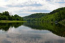
The White River is a 722-mile (1,162-km) long river
that flows through the U.S. state
s of Arkansas
and Missouri
.
of northwest Arkansas, in the Ozark-St. Francis National Forest
southeast of Fayetteville
. The river flows northwards from its source in northwest Arkansas
, loops up through southwest Missouri through Branson, Missouri. In Branson the river is actually Lake Taneycomo
since it is held back by the Powersite Dam
. The Powersite was the first dam on the White River. The flow into this comes from Table Rock Lake
and down stream flows into Bull Shoals Lake
where it travels back into Arkansas, and then heads generally southeast to its mouth at the Mississippi River
.
On entering the Mississippi River Delta region near Batesville, Arkansas
, the river becomes navigable to shallow-draft vessels, and its speed decreases considerably. The final 10 miles (16.1 km) of the river serves as the last segment of the McClellan-Kerr Arkansas River Navigation System; this part of the channel is deeper than the rest of the river.
Despite being much shorter than the Arkansas River
, it carries nearly as much water—normally over 8200 cuft/s, and as much as 40,000 ft³/s during flooding.
Lake Taneycomo
was created in 1913 when the Empire District Electric Company built a dam just south of Forsyth, Missouri
. Beaver Lake
, Bull Shoals Lake
, and Table Rock Lake
are man-made lakes or reservoir
s created by the U.S. Army Corps of Engineers
under the authority of the Flood Control Act of 1938. A total of eight dams impound the upper White River, six in Arkansas and two in Missouri. The White River National Wildlife Refuge
lies along the lower part of the river.
, Bayou des Arc
, Little Red River, Black River
, North Fork River
, Buffalo River
, James River
, and Roaring River
. Some cities that lie on the White River are Newport, Arkansas
; Augusta, Arkansas
; Calico Rock, Arkansas
; Batesville, Arkansas
; Branson, Missouri
; and Hollister, Missouri
.
River
A river is a natural watercourse, usually freshwater, flowing towards an ocean, a lake, a sea, or another river. In a few cases, a river simply flows into the ground or dries up completely before reaching another body of water. Small rivers may also be called by several other names, including...
that flows through the U.S. state
U.S. state
A U.S. state is any one of the 50 federated states of the United States of America that share sovereignty with the federal government. Because of this shared sovereignty, an American is a citizen both of the federal entity and of his or her state of domicile. Four states use the official title of...
s of Arkansas
Arkansas
Arkansas is a state located in the southern region of the United States. Its name is an Algonquian name of the Quapaw Indians. Arkansas shares borders with six states , and its eastern border is largely defined by the Mississippi River...
and Missouri
Missouri
Missouri is a US state located in the Midwestern United States, bordered by Iowa, Illinois, Kentucky, Tennessee, Arkansas, Oklahoma, Kansas and Nebraska. With a 2010 population of 5,988,927, Missouri is the 18th most populous state in the nation and the fifth most populous in the Midwest. It...
.
Course
The source of the White River is in the Boston MountainsBoston Mountains
The Boston Mountains area is a high and deeply dissected plateau located in northern Arkansas and eastern Oklahoma. The Oklahoma portion of the range is locally referred to as the Cookson Hills. The rocks of the region are essentially little disturbed, flat-lying sedimentary layers of the Paleozoic...
of northwest Arkansas, in the Ozark-St. Francis National Forest
Ozark-St. Francis National Forest
The Ozark – St. Francis National Forest is a United States National Forest that is located in the state of Arkansas. It is composed of two separate forests, Ozark National Forest and St. Francis National Forest, each with their own biological, topographical, and geological differences...
southeast of Fayetteville
Fayetteville, Arkansas
Fayetteville is the county seat of Washington County, and the third largest city in Arkansas. The city is centrally located within the county and is home to the University of Arkansas. Fayetteville is also deep in the Boston Mountains, a subset of The Ozarks...
. The river flows northwards from its source in northwest Arkansas
Arkansas
Arkansas is a state located in the southern region of the United States. Its name is an Algonquian name of the Quapaw Indians. Arkansas shares borders with six states , and its eastern border is largely defined by the Mississippi River...
, loops up through southwest Missouri through Branson, Missouri. In Branson the river is actually Lake Taneycomo
Lake Taneycomo
Lake Taneycomo is a man-made lake or reservoir on the White River in the Ozark Mountains of Taney County, Missouri. The reservoir is named for the county in which it is located: Taney County, MO....
since it is held back by the Powersite Dam
Powersite Dam
Powersite Dam is a hydroelectric dam that went into service in 1913 in Forsyth, Missouri. It is found along the White River and the reservoir it forms is Lake Taneycomo. It is the first hydroelectric dam built in Missouri.-Sources:...
. The Powersite was the first dam on the White River. The flow into this comes from Table Rock Lake
Table Rock Lake
Table Rock Lake is an artificial lake or reservoir in The Ozarks of southwestern Missouri and northwestern Arkansas. It is impounded by Table Rock Dam constructed in 1954-1958 on the White River by the U.S. Army Corps of Engineers. It is one of the tourist draws for the nearby town of Branson,...
and down stream flows into Bull Shoals Lake
Bull Shoals Lake
Bull Shoals Lake is an artificial lake or reservoir in the Ozark Mountains of northern Arkansas and southern Missouri. It has hundreds of miles of lake arms and coves perfect for boating, water sports, swimming, and fishing...
where it travels back into Arkansas, and then heads generally southeast to its mouth at the Mississippi River
Mississippi River
The Mississippi River is the largest river system in North America. Flowing entirely in the United States, this river rises in western Minnesota and meanders slowly southwards for to the Mississippi River Delta at the Gulf of Mexico. With its many tributaries, the Mississippi's watershed drains...
.
On entering the Mississippi River Delta region near Batesville, Arkansas
Batesville, Arkansas
Batesville is the county seat and largest city of Independence County, Arkansas, United States, 80 miles northeast of Little Rock, the state capital. According to 2005 Census Bureau estimates, the population of the city was 9,556...
, the river becomes navigable to shallow-draft vessels, and its speed decreases considerably. The final 10 miles (16.1 km) of the river serves as the last segment of the McClellan-Kerr Arkansas River Navigation System; this part of the channel is deeper than the rest of the river.
Despite being much shorter than the Arkansas River
Arkansas River
The Arkansas River is a major tributary of the Mississippi River. The Arkansas generally flows to the east and southeast as it traverses the U.S. states of Colorado, Kansas, Oklahoma, and Arkansas. The river's initial basin starts in the Western United States in Colorado, specifically the Arkansas...
, it carries nearly as much water—normally over 8200 cuft/s, and as much as 40,000 ft³/s during flooding.
River modifications
A controversial plan to deepen the navigation channel of the river (above the McClellan-Kerr segment) is under consideration though it is opposed by many Arkansans. The lower portion of the river contains a multitude of wildlife species including bear, turkey, songbirds, and over 160 species of fish. Many residents of Arkansas believe that deepening the navigation channel will adversely affect the wildlife which is a major source of tourism in the area. However, many farmers along parts of the White support the proposal for economic reasons.Lake Taneycomo
Lake Taneycomo
Lake Taneycomo is a man-made lake or reservoir on the White River in the Ozark Mountains of Taney County, Missouri. The reservoir is named for the county in which it is located: Taney County, MO....
was created in 1913 when the Empire District Electric Company built a dam just south of Forsyth, Missouri
Forsyth, Missouri
Forsyth is a city in Taney County, Missouri, United States. The population was 1,686 at the 2000 census. It is the county seat of Taney County. The town is part of the Branson, Missouri Micropolitan Statistical Area-Geography:...
. Beaver Lake
Beaver Lake (Arkansas)
Beaver Lake is a man-made reservoir in the Ozark Mountains of Northwest Arkansas and is formed by a dam across the White River. Beaver Lake has some of natural shoreline...
, Bull Shoals Lake
Bull Shoals Lake
Bull Shoals Lake is an artificial lake or reservoir in the Ozark Mountains of northern Arkansas and southern Missouri. It has hundreds of miles of lake arms and coves perfect for boating, water sports, swimming, and fishing...
, and Table Rock Lake
Table Rock Lake
Table Rock Lake is an artificial lake or reservoir in The Ozarks of southwestern Missouri and northwestern Arkansas. It is impounded by Table Rock Dam constructed in 1954-1958 on the White River by the U.S. Army Corps of Engineers. It is one of the tourist draws for the nearby town of Branson,...
are man-made lakes or reservoir
Reservoir
A reservoir , artificial lake or dam is used to store water.Reservoirs may be created in river valleys by the construction of a dam or may be built by excavation in the ground or by conventional construction techniques such as brickwork or cast concrete.The term reservoir may also be used to...
s created by the U.S. Army Corps of Engineers
United States Army Corps of Engineers
The United States Army Corps of Engineers is a federal agency and a major Army command made up of some 38,000 civilian and military personnel, making it the world's largest public engineering, design and construction management agency...
under the authority of the Flood Control Act of 1938. A total of eight dams impound the upper White River, six in Arkansas and two in Missouri. The White River National Wildlife Refuge
White River National Wildlife Refuge
The White River National Wildlife Refuge is a wildlife refuge located in Desha, Monroe, Phillips, and Arkansas counties in the U.S. state of Arkansas. The refuge is managed by the United States Fish and Wildlife Service....
lies along the lower part of the river.
Tributaries
The tributaries of the White River include Cache RiverCache River (Arkansas)
The Cache River is a tributary of the White River, 213 mi long, in northeastern Arkansas in the United States. Its headwaters also drain a small portion of southeastern Missouri...
, Bayou des Arc
Bayou des Arc
Bayou des Arc is a river in Arkansas. It is a tributary of the White River, into which it flows near the city of Des Arc in Prairie County, Arkansas. It rises in northwest White County, Arkansas, near the town of Rose Bud....
, Little Red River, Black River
Black River (Arkansas)
The Black River is a tributary of the White River, about 300 mi long , in southeastern Missouri and northeastern Arkansas in the United States. Via the White River, it is part of the Mississippi River watershed...
, North Fork River
North Fork River (Missouri - Arkansas)
The North Fork River or the North Fork of White River is a tributary of the White River, into which it flows near Norfork, Arkansas.It rises in Wright County, Missouri, southeast of the city of Mountain Grove, and flows generally southwards through Douglas and Ozark counties...
, Buffalo River
Buffalo National River
The Buffalo River, located in northern Arkansas, was the first National River to be designated in the United States. The Buffalo River is slightly more than in length, with the lower flowing within the boundaries of an area managed by the National Park Service, where it is designated the '. The...
, James River
James River (Missouri)
The James River is a river in southern Missouri. Its source is near the town of Diggins in Webster County. It begins on a northwesterly course, then turns southwest near Northview and passes near Springfield...
, and Roaring River
Roaring River (Missouri)
The Roaring River is a river in Barry County, Missouri, in the Ozarks. It is a tributary of the White River, into which it flows in Eagle Rock, Missouri. This section of the White River is a reservoir called Table Rock Lake....
. Some cities that lie on the White River are Newport, Arkansas
Newport, Arkansas
Newport is a city in Jackson County, Arkansas, northeast of Little Rock, on the White River. In 1900, 2,866 people lived in Newport, Arkansas; in 1910, 3,557. The population was 7,811 at the 2000 census. The city is the county seat of Jackson County....
; Augusta, Arkansas
Augusta, Arkansas
Augusta is a city in Woodruff County, Arkansas, United States. The population was 2,693 at the 2000 census. The city is the county seat of Woodruff County.-Geography:Augusta is located at ....
; Calico Rock, Arkansas
Calico Rock, Arkansas
Calico Rock is a city in Izard County, Arkansas, United States. The population was 991 at the 2000 census. The town celebrates a unique feature...
; Batesville, Arkansas
Batesville, Arkansas
Batesville is the county seat and largest city of Independence County, Arkansas, United States, 80 miles northeast of Little Rock, the state capital. According to 2005 Census Bureau estimates, the population of the city was 9,556...
; Branson, Missouri
Branson, Missouri
Branson is a city in Taney County in the U.S. state of Missouri. It was named after Reuben Branson, postmaster and operator of a general store in the area in the 1880s....
; and Hollister, Missouri
Hollister, Missouri
Hollister is a city in Taney County, Missouri, United States. The population was 4,426 at the 2010 census. It is part of the Branson, Missouri Micropolitan Statistical Area.-History:...
.
See also
- Cotter BridgeCotter BridgeThe Cotter Bridge, also known as the R.M. Ruthven Bridge and the White River Concrete Arch Bridge, carries the business route of U.S. Route 62 across the White River west of the city of Cotter in Baxter County, Arkansas, USA. Upon completion, the bridge allowed access to a part of The Ozarks...
- List of Arkansas rivers
- List of longest rivers of the United States (by main stem)
- List of Missouri rivers
- Whitewater Development CorporationWhitewater Development CorporationThe Whitewater Development Corporation was a failed business venture of James and Susan McDougal with Bill and Hillary Clinton. The business was incorporated on June 18, 1979, with the purpose of developing vacation properties on 230 acres of land along the White River near Flippin, Arkansas.-...
- White River MonsterWhite River MonsterThe White River Monster is a legendary large creature reportedly first spotted off the banks of the White River near Newport in northeastern Arkansas....