

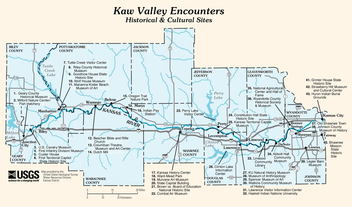
Kansas River
Encyclopedia
- Kaw River redirects here; for the state park, see Kaw River State ParkKaw River State ParkKaw River State Park is a state park in Topeka, Kansas, United States. Kaw River, the only urban type state park in Kansas, is relatively small at...
.
The Kansas River (also known as the Kaw) is a river
River
A river is a natural watercourse, usually freshwater, flowing towards an ocean, a lake, a sea, or another river. In a few cases, a river simply flows into the ground or dries up completely before reaching another body of water. Small rivers may also be called by several other names, including...
in northeastern Kansas
Kansas
Kansas is a US state located in the Midwestern United States. It is named after the Kansas River which flows through it, which in turn was named after the Kansa Native American tribe, which inhabited the area. The tribe's name is often said to mean "people of the wind" or "people of the south...
in the United States
United States
The United States of America is a federal constitutional republic comprising fifty states and a federal district...
. It is the southwestern-most part of the Missouri River
Missouri River
The Missouri River flows through the central United States, and is a tributary of the Mississippi River. It is the longest river in North America and drains the third largest area, though only the thirteenth largest by discharge. The Missouri's watershed encompasses most of the American Great...
drainage
Drainage
Drainage is the natural or artificial removal of surface and sub-surface water from an area. Many agricultural soils need drainage to improve production or to manage water supplies.-Early history:...
, which is in turn the northwestern-most portion of the extensive Mississippi River
Mississippi River
The Mississippi River is the largest river system in North America. Flowing entirely in the United States, this river rises in western Minnesota and meanders slowly southwards for to the Mississippi River Delta at the Gulf of Mexico. With its many tributaries, the Mississippi's watershed drains...
drainage. Its name (and nickname) come from the Kanza (Kaw)
Kaw (tribe)
The Kaw Nation are an American Indian people of the central Midwestern United States. The tribe known as Kaw have also been known as the "People of the South wind", "People of water", Kansa, Kaza, Kosa, and Kasa. Their tribal language is Kansa, classified as a Siouan language.The toponym "Kansas"...
people who once inhabited the area. The state of Kansas in turn drew its name from the river.
The river valley
River Valley
River Valley is the name of an urban planning area within the Central Area, Singapore's central business district.The River Valley Planning Area is defined by the region bounded by Orchard Boulevard, Devonshire Road and Eber Road to the north, Oxley Rise and Mohamed Sultan Road to the east, Martin...
averages 2.6 miles (4.2 km) in width, with the widest points being between Wamego
Wamego, Kansas
Wamego is a city in Pottawatomie County, Kansas, United States. The population was 4,246 at the 2000 census. It is part of the Manhattan, Kansas Metropolitan Statistical Area.-Geography:Wamego is located at...
and Rossville
Rossville, Kansas
Rossville is a city in Shawnee County, Kansas, United States. The population was 1,014 at the 2000 census. It is part of the Topeka, Kansas Metropolitan Statistical Area.-History:...
, where it is up to 4 miles (6.4 km) wide, then narrowing to 1 miles (1.6 km) or less in places below Eudora
Eudora, Kansas
Eudora is a city in Douglas County, Kansas, United States. It is part of the Lawrence, Kansas Metropolitan Statistical Area. The city is located along the Kansas and Wakarusa Rivers. As of the 2010 census, the city population was 6,136.- History :...
. Much of the river's watershed
Drainage basin
A drainage basin is an extent or an area of land where surface water from rain and melting snow or ice converges to a single point, usually the exit of the basin, where the waters join another waterbody, such as a river, lake, reservoir, estuary, wetland, sea, or ocean...
is dammed for flood control, but the Kansas River is generally free-flowing and has only minor obstructions, including diversion weir
Weir
A weir is a small overflow dam used to alter the flow characteristics of a river or stream. In most cases weirs take the form of a barrier across the river that causes water to pool behind the structure , but allows water to flow over the top...
s and one low impact hydroelectric dam.
Course
Beginning at the confluence of the RepublicanRepublican River
The Republican River is a river in the central Great Plains of North America, flowing through the U.S. states of Nebraska and Kansas.-Geography:...
and Smoky Hill
Smoky Hill River
The Smoky Hill River is a river in the central Great Plains of North America, running through the U.S. states of Colorado and Kansas.-Names:The Smoky Hill gets its name from the Smoky Hills region of north-central Kansas through which it flows...
rivers, just east of aptly named Junction City
Junction City, Kansas
Junction City is a city in and the county seat of Geary County, Kansas, United States. As of the 2010 census, the city population was 23,353. Fort Riley, a major U.S. Army post, is nearby...
(1030 feet (313.9 m)), the Kansas River flows some 148 miles (238.2 km) generally eastward to join the Missouri River
Missouri River
The Missouri River flows through the central United States, and is a tributary of the Mississippi River. It is the longest river in North America and drains the third largest area, though only the thirteenth largest by discharge. The Missouri's watershed encompasses most of the American Great...
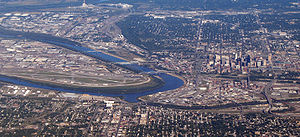
at Kaw Point
Kaw Point
Kaw Point is the name given to the point where the Kansas River terminates at the Missouri River in the West Bottoms area of Kansas City, Kansas. Kaw Point is also where the Missouri ceases its southerly course and turns to flow generally east through the State of Missouri to the Mississippi River...
(730 feet (222.5 m)) in Kansas City
Kansas City, Kansas
Kansas City is the third-largest city in the state of Kansas and is the county seat of Wyandotte County. It is a suburb of Kansas City, Missouri, and is the third largest city in the Kansas City Metropolitan Area. The city is part of a consolidated city-county government known as the "Unified...
. Dropping only 320 feet (97.5 m) on its journey seaward, the water in the Kansas River falls less than 2 ft/mi. The Kansas River valley
Valley
In geology, a valley or dale is a depression with predominant extent in one direction. A very deep river valley may be called a canyon or gorge.The terms U-shaped and V-shaped are descriptive terms of geography to characterize the form of valleys...
is only 115 miles (185.1 km) long; the surplus length of the river is due to meander
Meander
A meander in general is a bend in a sinuous watercourse. A meander is formed when the moving water in a stream erodes the outer banks and widens its valley. A stream of any volume may assume a meandering course, alternately eroding sediments from the outside of a bend and depositing them on the...
ing across the floodplain
Floodplain
A floodplain, or flood plain, is a flat or nearly flat land adjacent a stream or river that stretches from the banks of its channel to the base of the enclosing valley walls and experiences flooding during periods of high discharge...
. The river's course roughly follows the maximum extent of the Kansan glaciation
Kansan glaciation
The Kansan glaciation or Kansan glacial was glacial stage and part of an early conceptual climatic and chronological framework composed of four glacial and interglacial stages.-History:...
, and the river likely began as a path of glacial meltwater drainage.
Drainage
Nebraska
Nebraska is a state on the Great Plains of the Midwestern United States. The state's capital is Lincoln and its largest city is Omaha, on the Missouri River....
and 8775 square miles (22,727.1 km²) in Colorado
Colorado
Colorado is a U.S. state that encompasses much of the Rocky Mountains as well as the northeastern portion of the Colorado Plateau and the western edge of the Great Plains...
, making a total of just over 60000 square miles (155,399.3 km²). When including the Republican River
Republican River
The Republican River is a river in the central Great Plains of North America, flowing through the U.S. states of Nebraska and Kansas.-Geography:...
and its headwater tributaries, the Kansas River system has a length of 743 miles (1,195.7 km), making it the 21st longest river system in the United States. Its highest headwaters are at about 6000 feet (1,828.8 m) and extend nearly to Limon, Colorado
Limon, Colorado
Limon is a Statutory Town that is the most populous town in Lincoln County, Colorado, United States immediately east of Elbert County. The population was 2,071 at the 2000 census. Limon has been called the "Hub City" of Eastern Colorado because Interstate 70, U.S. Highways 24, 40, and 287, and...
. Much of the drainage of the river lies within the Great Plains
Great Plains
The Great Plains are a broad expanse of flat land, much of it covered in prairie, steppe and grassland, which lies west of the Mississippi River and east of the Rocky Mountains in the United States and Canada. This area covers parts of the U.S...
, but the river itself exists entirely within the Mid Continent Region
Mid-Continent Region (North America)
The Mid-Continent Region of the United States is a physiographic province that extends from northern Texas to Minnesota and covers portions of North and South Dakota, Nebraska, Kansas, Oklahoma, Arkansas, Missouri, and Iowa. This area is a transition between the Eastern Plains and drier, short...
. The majority of the rest of the state is drained by the Arkansas
Arkansas River
The Arkansas River is a major tributary of the Mississippi River. The Arkansas generally flows to the east and southeast as it traverses the U.S. states of Colorado, Kansas, Oklahoma, and Arkansas. The river's initial basin starts in the Western United States in Colorado, specifically the Arkansas...
(and its tributaties, the Neosho
Neosho River
The Neosho River is a tributary of the Arkansas River in eastern Kansas and northeastern Oklahoma in the United States. Its tributaries also drain portions of Missouri and Arkansas. The river is about long. Via the Arkansas, it is part of the Mississippi River watershed.- Course :The Neosho's...
, Cimarron, and Verdigris
Verdigris River
The Verdigris River is a tributary of the Arkansas River in southeastern Kansas and northeastern Oklahoma in the United States. It is about long...
, all three of which drain into the Arkansas in Oklahoma
Oklahoma
Oklahoma is a state located in the South Central region of the United States of America. With an estimated 3,751,351 residents as of the 2010 census and a land area of 68,667 square miles , Oklahoma is the 28th most populous and 20th-largest state...
). A portion of central-eastern Kansas is drained by the Marais des Cygnes River
Marais des Cygnes River
The Marais des Cygnes River is a principal tributary of the Osage River, about long, in eastern Kansas and western Missouri in the United States. Via the Osage and Missouri rivers, it is part of the watershed of the Mississippi River...
, which then flows into Missouri
Missouri
Missouri is a US state located in the Midwestern United States, bordered by Iowa, Illinois, Kentucky, Tennessee, Arkansas, Oklahoma, Kansas and Nebraska. With a 2010 population of 5,988,927, Missouri is the 18th most populous state in the nation and the fifth most populous in the Midwest. It...
to meet the Missouri River. There is also a small area in the extreme northeast part of the state that drains directly into the Missouri. In the Kansas City metro area, some streams drain east into the Blue River
Blue River (Missouri)
The Blue River is a stream that flows through Johnson County, Kansas and Jackson County, Missouri in the Kansas City Metropolitan Area. The river rises in Johnson County near the border of the states of Kansas and Missouri...
tributary of the Missouri.
Because of the river's shallow depth, slow drainage, high silt contents, and proximity to industrial centers, the Kansas River was ranked as the 21st most polluted water body in the United States.
Geology
The Kansas River flows through what is known as the Stable Interior region. Since this region is near the center of the North American PlateNorth American Plate
The North American Plate is a tectonic plate covering most of North America, Greenland, Cuba, Bahamas, and parts of Siberia, Japan and Iceland. It extends eastward to the Mid-Atlantic Ridge and westward to the Chersky Range in eastern Siberia. The plate includes both continental and oceanic crust...
, it has not experienced any extensive geologic faulting, folding
Fold (geology)
The term fold is used in geology when one or a stack of originally flat and planar surfaces, such as sedimentary strata, are bent or curved as a result of permanent deformation. Synsedimentary folds are those due to slumping of sedimentary material before it is lithified. Folds in rocks vary in...
, or mountain building
Orogeny
Orogeny refers to forces and events leading to a severe structural deformation of the Earth's crust due to the engagement of tectonic plates. Response to such engagement results in the formation of long tracts of highly deformed rock called orogens or orogenic belts...
in recent geologic time
Geologic time scale
The geologic time scale provides a system of chronologic measurement relating stratigraphy to time that is used by geologists, paleontologists and other earth scientists to describe the timing and relationships between events that have occurred during the history of the Earth...
. In fact, the river flows through limestone
Limestone
Limestone is a sedimentary rock composed largely of the minerals calcite and aragonite, which are different crystal forms of calcium carbonate . Many limestones are composed from skeletal fragments of marine organisms such as coral or foraminifera....
and shale
Shale
Shale is a fine-grained, clastic sedimentary rock composed of mud that is a mix of flakes of clay minerals and tiny fragments of other minerals, especially quartz and calcite. The ratio of clay to other minerals is variable. Shale is characterized by breaks along thin laminae or parallel layering...
strata
Stratum
In geology and related fields, a stratum is a layer of sedimentary rock or soil with internally consistent characteristics that distinguish it from other layers...
that, except for diagenesis
Diagenesis
In geology and oceanography, diagenesis is any chemical, physical, or biological change undergone by a sediment after its initial deposition and during and after its lithification, exclusive of surface alteration and metamorphism. These changes happen at relatively low temperatures and pressures...
, remain largely undisturbed since deposition
Deposition (geology)
Deposition is the geological process by which material is added to a landform or land mass. Fluids such as wind and water, as well as sediment flowing via gravity, transport previously eroded sediment, which, at the loss of enough kinetic energy in the fluid, is deposited, building up layers of...
beneath the Western Interior Seaway
Western Interior Seaway
The Western Interior Seaway, also called the Cretaceous Seaway, the Niobraran Sea, and the North American Inland Sea, was a huge inland sea that split the continent of North America into two halves, Laramidia and Appalachia, during most of the mid- and late-Cretaceous Period...
. The age of the rock
Rock (geology)
In geology, rock or stone is a naturally occurring solid aggregate of minerals and/or mineraloids.The Earth's outer solid layer, the lithosphere, is made of rock. In general rocks are of three types, namely, igneous, sedimentary, and metamorphic...
exposed by the river becomes progressively older as the river moves downstream for two main reasons. First, downstream areas experience more erosion
Erosion
Erosion is when materials are removed from the surface and changed into something else. It only works by hydraulic actions and transport of solids in the natural environment, and leads to the deposition of these materials elsewhere...
from increased flow, and second because the slight uplift of the Ozark dome
Dome (geology)
In structural geology, a dome is a deformational feature consisting of symmetrically-dipping anticlines; their general outline on a geologic map is circular or oval...
to the southeast caused the strata in Kansas to dip
Strike and dip
Strike and dip refer to the orientation or attitude of a geologic feature. The strike line of a bed, fault, or other planar feature is a line representing the intersection of that feature with a horizontal plane. On a geologic map, this is represented with a short straight line segment oriented...
very slightly to the west.
All of the rocks in the area are sedimentary
Sedimentary rock
Sedimentary rock are types of rock that are formed by the deposition of material at the Earth's surface and within bodies of water. Sedimentation is the collective name for processes that cause mineral and/or organic particles to settle and accumulate or minerals to precipitate from a solution....
, ranging from Late Pennsylvanian (300 million years ago) to recent, with three minor exceptions. The first is sand
Sand
Sand is a naturally occurring granular material composed of finely divided rock and mineral particles.The composition of sand is highly variable, depending on the local rock sources and conditions, but the most common constituent of sand in inland continental settings and non-tropical coastal...
and gravel
Gravel
Gravel is composed of unconsolidated rock fragments that have a general particle size range and include size classes from granule- to boulder-sized fragments. Gravel can be sub-categorized into granule and cobble...
brought down from the Rocky Mountains
Rocky Mountains
The Rocky Mountains are a major mountain range in western North America. The Rocky Mountains stretch more than from the northernmost part of British Columbia, in western Canada, to New Mexico, in the southwestern United States...
which have settled in the western extents of the Kansas River basin. Second, the retreat of the Kansan glaciation
Kansan glaciation
The Kansan glaciation or Kansan glacial was glacial stage and part of an early conceptual climatic and chronological framework composed of four glacial and interglacial stages.-History:...
left behind a combination of ice- and meltwater-deposited sediment
Sediment
Sediment is naturally occurring material that is broken down by processes of weathering and erosion, and is subsequently transported by the action of fluids such as wind, water, or ice, and/or by the force of gravity acting on the particle itself....
s known as drifta, a poorly sorted mixture of clay, sand, gravel, and even large boulders that cover parts of the extreme eastern portion of the Kansas River basin. The third is loess
Loess
Loess is an aeolian sediment formed by the accumulation of wind-blown silt, typically in the 20–50 micrometre size range, twenty percent or less clay and the balance equal parts sand and silt that are loosely cemented by calcium carbonate...
, a fine silt
Silt
Silt is granular material of a size somewhere between sand and clay whose mineral origin is quartz and feldspar. Silt may occur as a soil or as suspended sediment in a surface water body...
that may have originally been deposited by the melting water of the receding glaciers, then redeposited by the wind. The thickest loess deposits can be found in the northwest and north-central part of the Kansas River basin from southern Nebraska into northwest Kansas, as well as near the river's mouth.
History
Missouri River
The Missouri River flows through the central United States, and is a tributary of the Mississippi River. It is the longest river in North America and drains the third largest area, though only the thirteenth largest by discharge. The Missouri's watershed encompasses most of the American Great...
at about the 40th parallel
Latitude
In geography, the latitude of a location on the Earth is the angular distance of that location south or north of the Equator. The latitude is an angle, and is usually measured in degrees . The equator has a latitude of 0°, the North pole has a latitude of 90° north , and the South pole has a...
. This map, with virtually no changes except for the translation of French into English, was subsequently published by John Senex, a London
London
London is the capital city of :England and the :United Kingdom, the largest metropolitan area in the United Kingdom, and the largest urban zone in the European Union by most measures. Located on the River Thames, London has been a major settlement for two millennia, its history going back to its...
cartographer and engraver, in 1721.
Native Americans
Native Americans in the United States
Native Americans in the United States are the indigenous peoples in North America within the boundaries of the present-day continental United States, parts of Alaska, and the island state of Hawaii. They are composed of numerous, distinct tribes, states, and ethnic groups, many of which survive as...
, of course, used the river for transportation long before any Europeans knew of its existence. Their canoe
Canoe
A canoe or Canadian canoe is a small narrow boat, typically human-powered, though it may also be powered by sails or small electric or gas motors. Canoes are usually pointed at both bow and stern and are normally open on top, but can be decked over A canoe (North American English) or Canadian...
s, and the pirogue
Pirogue
A pirogue is a small, flat-bottomed boat of a design associated particularly with the Cajuns of the Louisiana marsh. In West Africa they were used as traditional fishing boats. These boats are not usually intended for overnight travel but are light and small enough to be easily taken onto land...
s of the French fur trade
Fur trade
The fur trade is a worldwide industry dealing in the acquisition and sale of animal fur. Since the establishment of world market for in the early modern period furs of boreal, polar and cold temperate mammalian animals have been the most valued...
rs, had a negligible draft
Draft (hull)
The draft of a ship's hull is the vertical distance between the waterline and the bottom of the hull , with the thickness of the hull included; in the case of not being included the draft outline would be obtained...
and easily navigated the river at any water level. From June 26 through 29, 1804, The Lewis and Clark Expedition
Lewis and Clark Expedition
The Lewis and Clark Expedition, or ″Corps of Discovery Expedition" was the first transcontinental expedition to the Pacific Coast by the United States. Commissioned by President Thomas Jefferson and led by two Virginia-born veterans of Indian wars in the Ohio Valley, Meriwether Lewis and William...
camped at Kaw Point
Kaw Point
Kaw Point is the name given to the point where the Kansas River terminates at the Missouri River in the West Bottoms area of Kansas City, Kansas. Kaw Point is also where the Missouri ceases its southerly course and turns to flow generally east through the State of Missouri to the Mississippi River...
at the river's mouth. They complimented the scenery and noted the area would be a good location for a fort.
In August, 1819, Maj. Stephen H. Long steered the first steamer
Steamboat
A steamboat or steamship, sometimes called a steamer, is a ship in which the primary method of propulsion is steam power, typically driving propellers or paddlewheels...
into the Kansas river with his 30-ton boat Western Engineer. He made it scarcely a mile up the river before turning back, citing mud bars from the recent floods.
The mouth of the Kansas River in the West Bottoms
West Bottoms
The West Bottoms is an industrial area immediately to the west of downtown Kansas City, Missouri at the confluence of the Missouri River and the Kansas River. The area is one of the oldest areas of the city....
area of Kansas City (sitting at a longitude
Longitude
Longitude is a geographic coordinate that specifies the east-west position of a point on the Earth's surface. It is an angular measurement, usually expressed in degrees, minutes and seconds, and denoted by the Greek letter lambda ....
of 94 degrees 36 minutes West) was the basis for Missouri's western boundary from Iowa
Iowa
Iowa is a state located in the Midwestern United States, an area often referred to as the "American Heartland". It derives its name from the Ioway people, one of the many American Indian tribes that occupied the state at the time of European exploration. Iowa was a part of the French colony of New...
to Arkansas
Arkansas
Arkansas is a state located in the southern region of the United States. Its name is an Algonquian name of the Quapaw Indians. Arkansas shares borders with six states , and its eastern border is largely defined by the Mississippi River...
when it became a state in 1821. (Kansas entered the Union
Union (American Civil War)
During the American Civil War, the Union was a name used to refer to the federal government of the United States, which was supported by the twenty free states and five border slave states. It was opposed by 11 southern slave states that had declared a secession to join together to form the...
in 1861.) South of the Missouri River, that longitude still remains the boundary between Kansas and Missouri. North of the Missouri River, the state of Missouri extended its boundary further to the west in 1836 with the Platte Purchase
Platte Purchase
The Platte Purchase was a land acquisition in 1836 by the United States government from Native American tribes all of which was east bank lands along the Missouri River that added to the northwest corner of the state of Missouri. The area acquired is almost as large as the states of Delaware and...
. The river has moved slightly since this designation, but the state boundary has remained the same. This line is known as the Osage Boundary.
From the 1840s through the early 1870s, the southern ridge
Ridge
A ridge is a geological feature consisting of a chain of mountains or hills that form a continuous elevated crest for some distance. Ridges are usually termed hills or mountains as well, depending on size. There are several main types of ridges:...
lines of the lower section of the Kansas River were the beginnings of the Oregon
Oregon Trail
The Oregon Trail is a historic east-west wagon route that connected the Missouri River to valleys in Oregon and locations in between.After 1840 steam-powered riverboats and steamboats traversing up and down the Ohio, Mississippi and Missouri rivers sped settlement and development in the flat...
, California
California Trail
The California Trail was an emigrant trail of about across the western half of the North American continent from Missouri River towns to what is now the state of California...
, and Santa Fe
Santa Fe Trail
The Santa Fe Trail was a 19th-century transportation route through central North America that connected Missouri with Santa Fe, New Mexico. Pioneered in 1822 by William Becknell, it served as a vital commercial and military highway until the introduction of the railroad to Santa Fe in 1880...
trails as they left Kansas City.
Beginning in 1854, steamboats operated regularly from Kansas City to Lawrence and Topeka, and sometimes as far as Fort Riley
Fort Riley
Fort Riley is a United States Army installation located in Northeast Kansas, on the Kansas River, between Junction City and Manhattan. The Fort Riley Military Reservation covers 100,656 acres in Geary and Riley counties and includes two census-designated places: Fort Riley North and Fort...
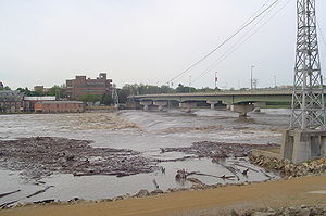
. This traffic continued through the territorial period and the early years of statehood, falling off rapidly about 1860. The last steamer to travel the Kansas was the Alexander Majors, which was chartered in 1866 to run between Kansas City and Lawrence until the railroad bridge at the mouth of the river, which had been destroyed by floods, could be rebuilt. This traffic into statehood gave the Kansas legal status as a navigable stream in the eyes of the Federal government. In the 1860s, the country's goods were increasingly transported by the extensive and comparatively efficient railroad system.
On February 25, 1864, the state legislature declared the Kansas River nonnavigable, allowing railroad and bridge companies to build bridges and dams without restriction. This law remained in effect until 1913, when, after it had been characterized as "a crime against the public welfare of Kansas", it was finally repealed and the river's status was restored to a navigable stream. The status has not since changed, though modern commercial navigation on the river is largely confined to dredging.
Recreation
Recreation along the Kansas River includes fishingFishing
Fishing is the activity of trying to catch wild fish. Fish are normally caught in the wild. Techniques for catching fish include hand gathering, spearing, netting, angling and trapping....
, canoeing
Canoeing
Canoeing is an outdoor activity that involves a special kind of canoe.Open canoes may be 'poled' , sailed, 'lined and tracked' or even 'gunnel-bobbed'....
and kayaking
Kayaking
Kayaking is the use of a kayak for moving across water. Kayaking and canoeing are also known as paddling. Kayaking is distinguished from canoeing by the sitting position of the paddler and the number of blades on the paddle...
, and rowing
Rowing (sport)
Rowing is a sport in which athletes race against each other on rivers, on lakes or on the ocean, depending upon the type of race and the discipline. The boats are propelled by the reaction forces on the oar blades as they are pushed against the water...
. There are 18 public access points along the river.http://www.buildasitefactory.com/index.php?id=123 The Friends of the Kaw organizes many float trips down the river each year (as well as cleanup efforts), and the Lawrence KOA rents canoes for self-guided trips. At least two rowing teams regularly use the river: The University of Kansas
University of Kansas
The University of Kansas is a public research university and the largest university in the state of Kansas. KU campuses are located in Lawrence, Wichita, Overland Park, and Kansas City, Kansas with the main campus being located in Lawrence on Mount Oread, the highest point in Lawrence. The...
rowing team uses the pool above the Bowersock dam for their exercises, and the Kansas City Rowing Club rows in the final stretches of the river, near its mouth.
On the river
- Kansas City: A few yards downstream from the I-435Interstate 435Interstate 435 is an Interstate Highway beltway that encircles much of the Kansas City, Missouri Metropolitan Area in the states of Kansas and Missouri, USA.- Route description :...
bridge, a weirWeirA weir is a small overflow dam used to alter the flow characteristics of a river or stream. In most cases weirs take the form of a barrier across the river that causes water to pool behind the structure , but allows water to flow over the top...
diverts water to an intake for WaterOne. Portage access is on the left bank. - Lawrence: Bowersock Dam is the largest obstruction on the river. It serves not only to create a standing pool for one of Lawrence's municipal water intakes (the other is at Clinton LakeClinton Lake (Kansas)Clinton Lake is a reservoir on the southwestern edge of Lawrence, Kansas. The lake was created by the construction of the Clinton Dam, and the 35 square miles of land and water is maintained by the U.S...
), but also it creates a headHydraulic headHydraulic head or piezometric head is a specific measurement of water pressure above a geodetic datum. It is usually measured as a water surface elevation, expressed in units of length, at the entrance of a piezometer...
for the Bowersock Mills & Power Company. At this site, the Bowersock Mills & Power Company operates the only hydroelectricHydroelectricityHydroelectricity is the term referring to electricity generated by hydropower; the production of electrical power through the use of the gravitational force of falling or flowing water. It is the most widely used form of renewable energy...
power stationPower stationA power station is an industrial facility for the generation of electric energy....
in Kansas: a 2.5 MW, Low Impact Hydropower Facility. The University of KansasUniversity of KansasThe University of Kansas is a public research university and the largest university in the state of Kansas. KU campuses are located in Lawrence, Wichita, Overland Park, and Kansas City, Kansas with the main campus being located in Lawrence on Mount Oread, the highest point in Lawrence. The...
's rowingRowing (sport)Rowing is a sport in which athletes race against each other on rivers, on lakes or on the ocean, depending upon the type of race and the discipline. The boats are propelled by the reaction forces on the oar blades as they are pushed against the water...
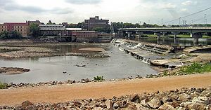
team uses the pool for its exercises. Portage access is on the left bank. - Tecumseh: An easily navigable low head weir exists that diverts water to the Tecumseh power plant, just downstream from Topeka.
- Topeka: A Topeka water department dam diverts water to the right bank for a municipal water intake. Portage access is on the left bank.
Within the watershed
The U.S. Army Corps of Engineers and the Bureau of Land ManagementBureau of Land Management
The Bureau of Land Management is an agency within the United States Department of the Interior which administers America's public lands, totaling approximately , or one-eighth of the landmass of the country. The BLM also manages of subsurface mineral estate underlying federal, state and private...
operate many reservoirs within the watershed
Drainage basin
A drainage basin is an extent or an area of land where surface water from rain and melting snow or ice converges to a single point, usually the exit of the basin, where the waters join another waterbody, such as a river, lake, reservoir, estuary, wetland, sea, or ocean...
of the Kansas river for local and Mississippi River flood
Flood
A flood is an overflow of an expanse of water that submerges land. The EU Floods directive defines a flood as a temporary covering by water of land not normally covered by water...
control, with secondary recreational uses.
Counties
- WyandotteWyandotte County, KansasWyandotte County is a county located in northeast Kansas, in the Central United States. The county's population was 157,505 for the 2010 census. Its county seat and most populous city is Kansas City with which it shares a unified government...
and JohnsonJohnson County, KansasJohnson County is a county located in northeast Kansas, in the central United States. The county is largely suburban, being part of the Kansas City metropolitan area, and containing many of its affluent southwestern suburbs. As of the 2010 census, the county population was 544,179. Its county...
(boundary in part) - JeffersonJefferson County, KansasJefferson County is a county located in Northeast Kansas, in the Central United States. As of the 2010 census, the county population was 19,126. Its county seat is Oskaloosa, and its most populous city is Valley Falls...
and DouglasDouglas County, KansasDouglas County is a county located in northeast Kansas, in the Central United States. As of the 2010 census, the county population was 110,826...
(boundary) - ShawneeShawnee County, KansasShawnee County is a county located in northeast Kansas, in the central United States of America. Its most populous city, Topeka, is the state capital and county seat. The county's population was 177,934 for the 2010 census...
- PottawatomiePottawatomie County, KansasPottawatomie County is a county located in the U.S. state of Kansas. As of the 2010 census, the county population was 21,604. The county seat is Westmoreland. The county takes its name from the Potawatomi tribe of Native Americans...
and WabaunseeWabaunsee County, KansasWabaunsee County is a county located in the U.S. state of Kansas. As of the 2010 census, the county population was 7,053. Its county seat is Alma. It is part of the Topeka, Kansas Metropolitan Statistical Area...
(boundary) - Riley
- GearyGeary County, KansasGeary County is a county located in Northeast Kansas, in the Central United States. As of the 2010 census, the county population was 34,362. Its county seat and most populous city is Junction City. The county is named in honor of Governor John W. Geary...
Cities and towns
| City/town | Elevation | |
|---|---|---|
| ft | m | |
| Kansas City Kansas City, Kansas Kansas City is the third-largest city in the state of Kansas and is the county seat of Wyandotte County. It is a suburb of Kansas City, Missouri, and is the third largest city in the Kansas City Metropolitan Area. The city is part of a consolidated city-county government known as the "Unified... |
730 | 222.5 |
| Shawnee Shawnee, Kansas Shawnee is a city located in northwest Johnson County, Kansas, United States and is a western suburb of Kansas City, Missouri. As of the 2010 census, the city population was 62,209. Shawnee's fur trading and pioneering heritage blends histories of these Kansas Territory townships: Monticello and... |
732 | 223.1 |
| Edwardsville Edwardsville, Kansas Edwardsville is a city in Wyandotte County, Kansas, United States and is part of the "Unified Government" which also contains Kansas City, Kansas, most of Bonner Springs, and roughly half of Lake Quivira. The city is a satellite city of Kansas City, Missouri... |
741 | 225.9 |
| Bonner Springs Bonner Springs, Kansas Bonner Springs is a river city in Johnson, Leavenworth, and Wyandotte counties in the U.S. state of Kansas. It is a suburb in the Kansas City, Missouri Metropolitan Area. The vast majority of the city, which lies in Wyandotte County, is part of the "Unified Government" which contains Kansas City,... |
762 | 232.3 |
| De Soto De Soto, Kansas De Soto is a city in Johnson and Leavenworth counties in the U.S. state of Kansas, along the Kansas River. The population was 4,561 at the 2000 census... |
764 | 232.9 |
| Lawrence Lawrence, Kansas Lawrence is the sixth largest city in the U.S. State of Kansas and the county seat of Douglas County. Located in northeastern Kansas, Lawrence is the anchor city of the Lawrence, Kansas, Metropolitan Statistical Area, which encompasses all of Douglas County... |
791 | 241.1 |
| Lecompton Lecompton, Kansas Lecompton is a city in Douglas County, Kansas, United States. It is part of the Lawrence, Kansas Metropolitan Statistical Area. The population was 608 at the 2000 census. Lecompton played a major historical role in pre-Civil War America as the Territorial capital of Kansas from 1855 to 1861... |
820 | 249.9 |
| Perry Perry, Kansas Perry is a city in Jefferson County, Kansas, United States. The population was 901 at the 2000 census. It is part of the Topeka, Kansas Metropolitan Statistical Area.-History:... |
820 | 249.9 |
| Tecumseh Tecumseh, Kansas Tecumseh is an unincorporated community situated along the Kansas River in eastern Shawnee County, located in northeast Kansas, in the central United States of America. It is part of the Topeka, Kansas Metropolitan Statistical Area. Although official populations are not compiled for... |
840 | 256 |
| Topeka Topeka, Kansas Topeka |Kansa]]: Tó Pee Kuh) is the capital city of the U.S. state of Kansas and the county seat of Shawnee County. It is situated along the Kansas River in the central part of Shawnee County, located in northeast Kansas, in the Central United States. As of the 2010 census, the city population was... |
852 | 259.7 |
| Willard Willard, Kansas Willard is a city in Shawnee and Wabaunsee counties in the U.S. state of Kansas. The population was 86 at the 2000 census. It is part of the Topeka, Kansas Metropolitan Statistical Area.-History:... |
889 | 271 |
| Belvue Belvue, Kansas Belvue is a city in Pottawatomie County, Kansas, United States. The population was 228 at the 2000 census. It is part of the Manhattan, Kansas Metropolitan Statistical Area.-Geography:Belvue is located at .... |
911 | 277.7 |
| Wamego Wamego, Kansas Wamego is a city in Pottawatomie County, Kansas, United States. The population was 4,246 at the 2000 census. It is part of the Manhattan, Kansas Metropolitan Statistical Area.-Geography:Wamego is located at... |
955 | 291.1 |
| St. George St. George, Kansas St. George is a city in Pottawatomie County, Kansas, United States. As of the 2010 census, the city population was 639. It is part of the Manhattan, Kansas Metropolitan Statistical Area.-Geography:St. George is located at... |
977 | 297.8 |
| Manhattan Manhattan, Kansas Manhattan is a city located in the northeastern part of the state of Kansas in the United States, at the junction of the Kansas River and Big Blue River. It is the county seat of Riley County and the city extends into Pottawatomie County. As of the 2010 census, the city population was 52,281... |
990 | 301.8 |
| Ogden Ogden, Kansas Ogden is a city in Riley County, Kansas, United States. As of the 2010 census, the city population was 2,087. It is part of the Manhattan, Kansas Metropolitan Statistical Area.-History:... |
1023 | 311.8 |
| Ft. Riley | 1040 | 317 |
| Junction City Junction City, Kansas Junction City is a city in and the county seat of Geary County, Kansas, United States. As of the 2010 census, the city population was 23,353. Fort Riley, a major U.S. Army post, is nearby... |
1047 | 319.1 |
| major cities in bold | ||
Tributaries
- Wakarusa RiverWakarusa RiverThe Wakarusa River is a tributary of the Kansas River, approximately long, in eastern Kansas in the United States. It drains an agricultural area of rolling limestone hills south of Topeka and Lawrence.-Description:...
- Big Blue RiverBig Blue River (Kansas)The Big Blue River is the largest tributary of the Kansas River. The river flows for approximately from central Nebraska into Kansas, where it intersects with the Kansas River east of Manhattan. It was given its name by the Kansa tribe of Native Americans, who lived at its mouth from 1780 to...
- Republican RiverRepublican RiverThe Republican River is a river in the central Great Plains of North America, flowing through the U.S. states of Nebraska and Kansas.-Geography:...
- Smoky Hill RiverSmoky Hill RiverThe Smoky Hill River is a river in the central Great Plains of North America, running through the U.S. states of Colorado and Kansas.-Names:The Smoky Hill gets its name from the Smoky Hills region of north-central Kansas through which it flows...
- Delaware RiverDelaware River (Kansas)The Delaware River is a river located in the northeastern part of the state of Kansas. The Delaware River basin drains from the outflow of the Perry Lake reservoir...