
Illinois and Michigan Canal
Encyclopedia
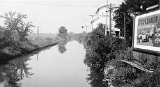
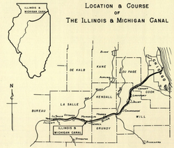
The Illinois and Michigan Canal ran 96 miles (154.5 km) from the Bridgeport
neighborhood in Chicago
on the Chicago River
to LaSalle-Peru, Illinois, on the Illinois River
. It was finished in 1848 when Chicago Mayor James Hutchinson Woodworth
presided over its opening; and it allowed boat transportation from the Great Lakes to the Mississippi River
and the Gulf of Mexico
. The canal enabled navigation
across the Chicago Portage
and helped establish Chicago as the transportation hub of the United States, opening before railroads were laid in the area. Its function was largely replaced by the wider and shorter Chicago Sanitary and Ship Canal
in 1900 and it ceased transportation operations in 1933.
Illinois and Michigan Canal Locks and Towpath, a collection of eight engineering structures and segments of the canal between Lockport and LaSalle-Peru, was designated a National Historic Landmark
in 1964.
Portions of the canal have been filled in. Much of the former canal has been preserved as part of the Illinois and Michigan Canal National Heritage Corridor.
 In 1824, Samuel D. Lockwood
, one of the first commissioners of the canal, was given the authorization to hire contractors to survey a route for the canal to follow.
Construction on the canal began in 1836, although it was stopped for several years due to an Illinois
state fiscal crisis related to the Panic of 1837
. The Canal Commission had a grant of 284000 acres (1,149,308.2 km) of federal land which it sold at $1.25 per acre (309 $/km²) to finance the construction. Still, money had to be borrowed from eastern U.S. and British
investors to finish the canal.
Most of the canal work was done by Irish
immigrants who previously worked
on the Erie Canal
. The work was considered dangerous and many workers died, although no official records exist to indicate how many. The Irish immigrants who toiled to build the canal were often derided as a sub-class and were treated very poorly by other citizens of the city.
The canal was finished in 1848 with a total cost of $6,170,226. Pumps were used to draw water to fill the canal near Chicago, soon supplemented by the Calumet Feeder Canal, and the DuPage River
supplied water farther south. In 1871 the canal was deepened to speed up the current and to improve sewage
disposal.
The canal was eventually 60 feet (20 m) wide and six feet (2 m) deep, with paths constructed along each edge to permit mules to be harnessed to tow barges along the canal. Towns were planned out along the path of the canal spaced at intervals corresponding to the length that the mules could haul the barges. It had seventeen locks and four aqueducts to cover the 140 foot (45 m) height difference between Lake Michigan and the Illinois River. From 1848 to 1852 the canal was a popular passenger route, but this ended in 1853 with the opening of the Chicago, Rock Island and Pacific Railroad
that ran parallel to the canal. The canal had its peak shipping year in 1882 and remained in use until 1933. It was replaced in 1900 by the larger Chicago Sanitary and Ship Canal, which remains in use.
Experiencing a remarkable recovery from the devastating fire of 1871, Chicago rebuilt rapidly along the shores of the Chicago River. The river was especially important to the development of the city since all wastes from houses, farms, the stockyards, and other industries could be dumped into the river and carried out into Lake Michigan.
The lake, however, was also the source of drinking water. During a tremendous storm in 1885, the rainfall washed refuse from the river, especially from the highly polluted Bubbly Creek
, far out into the lake (the city water intakes are located 2 miles (3.2 km) offshore). Although no epidemics occurred
, the Chicago Sanitary District (now The Metropolitan Water Reclamation District
) was created by the Illinois legislature in 1889 in response to this close call.
This new agency devised a plan to construct channels and canals to reverse the flow of the rivers away from Lake Michigan and divert the contaminated water downstream where it could be diluted as it flowed into the Des Plaines and eventually the Mississippi.
_tow_downbound.jpg) In 1892, the direction of part of the Chicago River was reversed by the Army Corps of Engineers with the result that the river and much of Chicago's sewage flowed into the canal instead of into Lake Michigan
In 1892, the direction of part of the Chicago River was reversed by the Army Corps of Engineers with the result that the river and much of Chicago's sewage flowed into the canal instead of into Lake Michigan
. The complete reversal of the river's flow was accomplished when the Sanitary and Ship Canal was opened in 1900.
Today much of the canal is a long, thin park with canoeing and a 62.5 miles (100.6 km) hiking and biking trail (constructed on the alignment of the mule tow paths). It also includes museums and historical canal buildings. It was designated the first National Heritage Corridor by US Congress in 1984.
From east to west the towns along the path of the canal include:
Bridgeport, Chicago
Bridgeport, one of 77 community areas of Chicago, is a neighborhood located on the city's South Side. It is bounded, generally, on the west and north by the Chicago River, on the east by Canal Street, and on the south by Pershing Road.-History:...
neighborhood in Chicago
Chicago
Chicago is the largest city in the US state of Illinois. With nearly 2.7 million residents, it is the most populous city in the Midwestern United States and the third most populous in the US, after New York City and Los Angeles...
on the Chicago River
Chicago River
The Chicago River is a system of rivers and canals with a combined length of that runs through the city of the same name, including its center . Though not especially long, the river is notable for being the reason why Chicago became an important location, as the link between the Great Lakes and...
to LaSalle-Peru, Illinois, on the Illinois River
Illinois River
The Illinois River is a principal tributary of the Mississippi River, approximately long, in the State of Illinois. The river drains a large section of central Illinois, with a drainage basin of . This river was important among Native Americans and early French traders as the principal water route...
. It was finished in 1848 when Chicago Mayor James Hutchinson Woodworth
James Hutchinson Woodworth
James Hutchinson Woodworth , was a former member of the Illinois State Senate and the Illinois State House of Representatives, served as a Chicago Alderman, was elected to consecutive terms as Mayor of Chicago, Illinois as an Independent Democrat, and served one term in the US House...
presided over its opening; and it allowed boat transportation from the Great Lakes to the Mississippi River
Mississippi River
The Mississippi River is the largest river system in North America. Flowing entirely in the United States, this river rises in western Minnesota and meanders slowly southwards for to the Mississippi River Delta at the Gulf of Mexico. With its many tributaries, the Mississippi's watershed drains...
and the Gulf of Mexico
Gulf of Mexico
The Gulf of Mexico is a partially landlocked ocean basin largely surrounded by the North American continent and the island of Cuba. It is bounded on the northeast, north and northwest by the Gulf Coast of the United States, on the southwest and south by Mexico, and on the southeast by Cuba. In...
. The canal enabled navigation
Navigation
Navigation is the process of monitoring and controlling the movement of a craft or vehicle from one place to another. It is also the term of art used for the specialized knowledge used by navigators to perform navigation tasks...
across the Chicago Portage
Chicago Portage
The Chicago Portage connects the watersheds and the navigable waterways of the Mississippi River and the Great Lakes. It crosses the continental divide that separates the Great Lakes and Gulf of St. Lawrence watersheds from the Gulf of Mexico watershed.Near Chicago, the St...
and helped establish Chicago as the transportation hub of the United States, opening before railroads were laid in the area. Its function was largely replaced by the wider and shorter Chicago Sanitary and Ship Canal
Chicago Sanitary and Ship Canal
The Chicago Sanitary and Ship Canal, historically known as the Chicago Drainage Canal, is the only shipping link between the Great Lakes and the Mississippi River system, by way of the Illinois and Des Plaines Rivers...
in 1900 and it ceased transportation operations in 1933.
Illinois and Michigan Canal Locks and Towpath, a collection of eight engineering structures and segments of the canal between Lockport and LaSalle-Peru, was designated a National Historic Landmark
National Historic Landmark
A National Historic Landmark is a building, site, structure, object, or district, that is officially recognized by the United States government for its historical significance...
in 1964.
Portions of the canal have been filled in. Much of the former canal has been preserved as part of the Illinois and Michigan Canal National Heritage Corridor.
History
Samuel D. Lockwood
Samuel Drake Lockwood was an Illinois politician who served as the state's Attorney General, Secretary of State, and Supreme Court Justice....
, one of the first commissioners of the canal, was given the authorization to hire contractors to survey a route for the canal to follow.
Construction on the canal began in 1836, although it was stopped for several years due to an Illinois
Illinois
Illinois is the fifth-most populous state of the United States of America, and is often noted for being a microcosm of the entire country. With Chicago in the northeast, small industrial cities and great agricultural productivity in central and northern Illinois, and natural resources like coal,...
state fiscal crisis related to the Panic of 1837
Panic of 1837
The Panic of 1837 was a financial crisis or market correction in the United States built on a speculative fever. The end of the Second Bank of the United States had produced a period of runaway inflation, but on May 10, 1837 in New York City, every bank began to accept payment only in specie ,...
. The Canal Commission had a grant of 284000 acres (1,149,308.2 km) of federal land which it sold at $1.25 per acre (309 $/km²) to finance the construction. Still, money had to be borrowed from eastern U.S. and British
United Kingdom
The United Kingdom of Great Britain and Northern IrelandIn the United Kingdom and Dependencies, other languages have been officially recognised as legitimate autochthonous languages under the European Charter for Regional or Minority Languages...
investors to finish the canal.
Most of the canal work was done by Irish
Irish people
The Irish people are an ethnic group who originate in Ireland, an island in northwestern Europe. Ireland has been populated for around 9,000 years , with the Irish people's earliest ancestors recorded having legends of being descended from groups such as the Nemedians, Fomorians, Fir Bolg, Tuatha...
immigrants who previously worked
Navvy
Navvy is a shorter form of navigator or navigational engineer and is particularly applied to describe the manual labourers working on major civil engineering projects...
on the Erie Canal
Erie Canal
The Erie Canal is a waterway in New York that runs about from Albany, New York, on the Hudson River to Buffalo, New York, at Lake Erie, completing a navigable water route from the Atlantic Ocean to the Great Lakes. The canal contains 36 locks and encompasses a total elevation differential of...
. The work was considered dangerous and many workers died, although no official records exist to indicate how many. The Irish immigrants who toiled to build the canal were often derided as a sub-class and were treated very poorly by other citizens of the city.
The canal was finished in 1848 with a total cost of $6,170,226. Pumps were used to draw water to fill the canal near Chicago, soon supplemented by the Calumet Feeder Canal, and the DuPage River
DuPage River
The DuPage River is a tributary of the Des Plaines River in the U.S. state of Illinois.-Course:The river begins as two individual streams. The West Branch of the DuPage River, long, starts in Schaumburg at Campanelli Park in Cook County and continues southward through the entire county of DuPage,...
supplied water farther south. In 1871 the canal was deepened to speed up the current and to improve sewage
Sewage
Sewage is water-carried waste, in solution or suspension, that is intended to be removed from a community. Also known as wastewater, it is more than 99% water and is characterized by volume or rate of flow, physical condition, chemical constituents and the bacteriological organisms that it contains...
disposal.
The canal was eventually 60 feet (20 m) wide and six feet (2 m) deep, with paths constructed along each edge to permit mules to be harnessed to tow barges along the canal. Towns were planned out along the path of the canal spaced at intervals corresponding to the length that the mules could haul the barges. It had seventeen locks and four aqueducts to cover the 140 foot (45 m) height difference between Lake Michigan and the Illinois River. From 1848 to 1852 the canal was a popular passenger route, but this ended in 1853 with the opening of the Chicago, Rock Island and Pacific Railroad
Chicago, Rock Island and Pacific Railroad
The Chicago, Rock Island and Pacific Railroad was a Class I railroad in the United States. It was also known as the Rock Island Line, or, in its final years, The Rock.-Incorporation:...
that ran parallel to the canal. The canal had its peak shipping year in 1882 and remained in use until 1933. It was replaced in 1900 by the larger Chicago Sanitary and Ship Canal, which remains in use.
Experiencing a remarkable recovery from the devastating fire of 1871, Chicago rebuilt rapidly along the shores of the Chicago River. The river was especially important to the development of the city since all wastes from houses, farms, the stockyards, and other industries could be dumped into the river and carried out into Lake Michigan.
The lake, however, was also the source of drinking water. During a tremendous storm in 1885, the rainfall washed refuse from the river, especially from the highly polluted Bubbly Creek
Bubbly Creek
Bubbly Creek is the nickname given to the South Fork of the Chicago River's South Branch, which runs entirely within the city of Chicago, Illinois. Gases bubbling out of the riverbed from the decomposition of blood and entrails dumped into the river by the local stockyards in the early 20th...
, far out into the lake (the city water intakes are located 2 miles (3.2 km) offshore). Although no epidemics occurred
Chicago 1885 cholera epidemic myth
The Chicago 1885 cholera epidemic myth is a persistent urban legend, stating that 90,000 people in Chicago died of typhoid fever and cholera in 1885. Although the story is widely reported, these deaths did not occur....
, the Chicago Sanitary District (now The Metropolitan Water Reclamation District
Metropolitan Water Reclamation District of Greater Chicago
The Metropolitan Water Reclamation District of Greater Chicago , originally known as the Sanitary District of Chicago is a special-purpose district, chartered to operate in northern Illinois since 1889...
) was created by the Illinois legislature in 1889 in response to this close call.
This new agency devised a plan to construct channels and canals to reverse the flow of the rivers away from Lake Michigan and divert the contaminated water downstream where it could be diluted as it flowed into the Des Plaines and eventually the Mississippi.
Lake Michigan
Lake Michigan is one of the five Great Lakes of North America and the only one located entirely within the United States. It is the second largest of the Great Lakes by volume and the third largest by surface area, after Lake Superior and Lake Huron...
. The complete reversal of the river's flow was accomplished when the Sanitary and Ship Canal was opened in 1900.
Today much of the canal is a long, thin park with canoeing and a 62.5 miles (100.6 km) hiking and biking trail (constructed on the alignment of the mule tow paths). It also includes museums and historical canal buildings. It was designated the first National Heritage Corridor by US Congress in 1984.
From east to west the towns along the path of the canal include:
- BridgeportBridgeport, ChicagoBridgeport, one of 77 community areas of Chicago, is a neighborhood located on the city's South Side. It is bounded, generally, on the west and north by the Chicago River, on the east by Canal Street, and on the south by Pershing Road.-History:...
(Chicago neighborhood) - SummitSummit, IllinoisSummit is a village in Cook County, Illinois, United States. The population was 10,637 at the 2000 census. The village is best known as the setting to Ernest Hemingway's 1927 short story "The Killers".-Geography:...
- Willow SpringsWillow Springs, IllinoisWillow Springs is a village in Cook and DuPage Counties, Illinois, United States. The population was 5,027 at the 2000 census.-Geography:Willow Springs is located at ....
- LemontLemont, IllinoisLemont is a village located in Cook, DuPage, and Will Counties in the U.S. state of Illinois, and is roughly southwest of Chicago. The population was 16,625 at the 2007 Special Census.-History:...
- RomeovilleRomeoville, IllinoisRomeoville is a village in Will County, Illinois, United States. The population was 21,153 at the 2000 census. As of 2006 the population has grown to 36,837. It is located in the southwest suburban area of Chicago near the newly constructed I-355 extension south from the Stevenson Expressway to I-80...
- LockportLockport, IllinoisLockport is a city in Will County, Illinois, United States, that incorporated in 1853. Lockport is located in northeastern Illinois, 30 miles southwest of Chicago, and north of Joliet, at locks connecting Chicago Sanitary and Ship Canal with the Des Plaines River via the Lockport...
- JolietJoliet, IllinoisJoliet is a city in Will and Kendall Counties in the U.S. state of Illinois, located southwest of Chicago. It is the county seat of Will County. As of the 2010 census, the city was the fourth-most populated in Illinois, with a population of 147,433. It continues to be Illinois' fastest growing...
- ChannahonChannahon, IllinoisChannahon is a village in Grundy and Will counties in the U.S. state of Illinois. The population was 12,560 at the 2010 census. Channahon is also the name of the township in which most of the village resides...
- MorrisMorris, IllinoisMorris is a city in Grundy County, Illinois, United States. The population was 13,636 at the 2010 census.Morris is home to the Dresden Nuclear Power Plant, which provides a substantial portion of the electricity supply for the Chicago metropolitan area...
- SenecaSeneca, IllinoisSeneca is a village in LaSalle and Grundy counties in the U.S. state of Illinois. The population was 2,371 at the 2010 census.The LaSalle County portion of Seneca is part of the Ottawa–Streator Micropolitan Statistical Area, while the small portion that lies in Grundy County is part of the...
- MarseillesMarseilles, IllinoisMarseilles is a city in LaSalle County, Illinois, United States. The population was 4,655 at the 2000 census. It is part of the Ottawa–Streator Micropolitan Statistical Area.-History:...
- OttawaOttawa, IllinoisOttawa is a city located at the confluence of the Illinois River and Fox River in LaSalle County, Illinois, USA. As of the 2010 census, the city population was 18,786...
- Utica
- LaSalle
- PeruPeru, IllinoisPeru is a city in LaSalle County, Illinois, United States. The population was 10,295 at the 2010 census. It is part of the Ottawa–Streator Micropolitan Statistical Area...
See also
- Matthew LaflinMatthew LaflinMatthew Laflin was an American manufacturer of gunpowder, businessman, philanthropist, and an early pioneer of Chicago, Illinois.-Early life and ancestors:...
- Metropolitan Water Reclamation District of Greater ChicagoMetropolitan Water Reclamation District of Greater ChicagoThe Metropolitan Water Reclamation District of Greater Chicago , originally known as the Sanitary District of Chicago is a special-purpose district, chartered to operate in northern Illinois since 1889...
- Treaty of St. LouisTreaty of St. LouisThe Treaty of St. Louis is one of many treaties signed between the United States and various Native American tribes.-1804 - Sauk and Fox :...
- Shabbona TrailShabbona TrailThe Chief Shabbona Trail is a hiking, bicycling and canoeing trail, located between Joliet and Morris, Illinois. The Shabbona Trail is a part of the long National Park Service Illinois and Michigan Canal National Heritage Corridor....
includes 20 miles (32.2 km) of the Illinois and Michigan Canal Trail. - Channahon State ParkChannahon State ParkChannahon State Park is an Illinois state park in Will County, Illinois, United States. The park was named after a Native American word meaning "the meeting of the waters". It lies adjacent to the confluence of the Dupage, Des Plaines, and Kankakee Rivers....
- Gebhard Woods State ParkGebhard Woods State ParkGebhard Woods State Park is an Illinois state park on in Grundy County, Illinois, United States. Originally was owned by Mrs. William Gebhard, but was bought by the Grundy County Rod & Gun Club in 1934...
- The Volunteer (canal boat)The Volunteer (canal boat)The Volunteer is a 76-foot replica of a 19th Century canal boat which is owned and operated by the Canal Corridor Association. The Volunteer operates on a restored section of the Illinois and Michigan Canal at LaSalle, Illinois.- Construction :...
- David Leavitt (banker)David Leavitt (banker)David Leavitt was an early New York City banker and financier. As president of the American Exchange Bank of New York during the Financial Panic of 1837 he represented bondholders of the nascent Illinois and Michigan Canal, allowing completion of the historic canal linking the Midwest with the...
External links
- Illinois & Michigan Canal National Heritage Corridor
- Canal and Regional History Special Collection at Lewis University
- Illinois & Michigan Canal State Trail
- Chicago Historical Society: Illinois & Michigan Canal
- The Illinois and Michigan Canal, 1827–1911: A Selection of Documents from the Illinois State Archives
- Metropolitan Water Reclamation District of Greater Chicago
- Canal Corridor Association
- Ottawa Visitors Center
- Will County Historical Society, housed in original Canal Office