
Chicago River
Encyclopedia
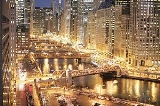
The Chicago River is a system of rivers and canals with a combined length of 156 miles (251.1 km) that runs through the city of the same name
, including its center (the Chicago Loop
). Though not especially long, the river is notable for being the reason why Chicago became an important location, as the link between
the Great Lakes
and the Mississippi Valley waterways. In the 19th century through civil engineering
, the flow of the river was reversed to head toward the Mississippi River
basin, away from Lake Michigan
, into which it previously emptied. This was done for reasons of sanitation. The river is also noted for the local custom of dyeing it green on St. Patrick's Day.
The river is memorialized, in part, by two horizontal blue stripes on the Municipal Flag of Chicago. The river also serves as inspiration for one of Chicago's ubiquitous symbols: a three-branched, Y-shaped symbol (called the municipal device) is found on many buildings and other structures throughout Chicago; it represents the three branches of the Chicago River.
entering Lake Michigan at about the level of present day Madison Street
. Today, the Main Stem of the Chicago River flows west from Lake Michigan to Wolf Point, where it converges with the North Branch to form the South Branch, which flows south west and empties into the Chicago Sanitary and Ship Canal
.
—or East Fork—rises from a flat area, historically a wetland, near Park City, Illinois
to the west of the city of Waukegan
.It then flows southward, paralleling the edge of Lake Michigan, through wetlands, the Greenbelt Forest Preserve and a number of golf courses towards Highland Park, Illinois
. South of Highland Park the river passes the Chicago Botanic Gardens and though an area of former marshlands known as the Skokie Lagoons
. The Middle Fork arises near Rondout, Illinois and flows southwards through Lake Forest
and Highland Park. These two tributaries merge at Watersmeet Woods west of Wilmette
, from there the North Branch flows south towards Morton Grove
. The West Fork rises near Mettawa
and flows south through Bannockburn
, Deerfield
, and Northbrook
, meeting the North Branch at Morton Grove.
 The North Branch continues southwards though Niles
, entering the city of Chicago near the intersection of Milwaukee Avenue
and Devon Avenue
, from where it serves as the boundary of the Forest Glen
community area with Norwood Park
and Jefferson Park
. On this stretch of the river it meanders in a south-easterly direction, passing through golf courses and forest preserves
until it reaches Foster Avenue
, where it passes through residential neighborhoods on the north side of the Albany Park
community area. In West River Park the river meets the North Shore Channel
, a drainage canal built between 1907 and 1910 to increase the flow of the North Branch and help flush pollution into the Chicago Sanitary and Ship Canal
. From the confluence with the North Shore Channel south to Belmont Avenue the North Branch flows through mostly residential neighborhoods in a man-made channel that was dug to straighten and deepen the river, helping it to carry the additional flow from the North Shore Channel.
South of Belmont the North Branch is lined with a mixture of residential developments, retail parks, and industry until it reaches the industrial area known as the Clybourn Corridor. Here is passes beneath the Cortland Street Drawbridge
, which was the first 'Chicago-style' fixed-trunnion bascule bridge
built in the United States
, and is designated as an ASCE
Civil Engineering Landmark and a Chicago Landmark
.
At North Avenue, south of the North Avenue Bridge
, the North Branch divides, the original course of the river makes a curve along the west side of Goose Island
, whilst the North Branch Canal cuts off the bend, forming the island. The North Branch Canal—or Ogden's Canal—was completed in 1857, and was originally 50 feet (15.2 m) wide and 10 feet (3 m) deep allowing craft navigating the river to avoid the bend. The 1902 Cherry Avenue Bridge
, just south of North Avenue, was constructed to carry the Chicago, Milwaukee and St. Paul Railway onto Goose Island. It is rare example of an asymmetric bob-tail swing bridge and was designated a Chicago Landmark in 2007. From Goose Island the North Branch continues to flow south east to Wolf Point where it joins the Main Stem.
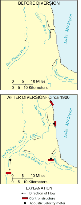
 The source of the Main Stem of the Chicago River is Lake Michigan. Water enters the river through sluice gates at the Chicago River Controlling Works with a small additional flow provided by the passage of boats between the river and Lake Michigan through the Chicago Lock. The surface level of the river is maintained at 0.5 to 2 ft (0.1524 to 0.6096 m) below the Chicago City Datum (579.48 feet (176.6 m) above mean sea level) except for when there is excessive storm run-off into the river or when the level of the lake is more than 2 feet below the Chicago City Datum. Acoustic
velocity meters at the Columbus Drive Bridge and the T.J. O'Brien lock on the Calumet River
monitor the diversion of water from Lake Michigan to the Mississippi River basin, which is limited to an average of 3200 cubic feet (90.6 m³) per second per year over the 40 year period from 1980 to 2020.
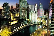
The Main Stem flows 1.5 miles (2.4 km) west from the controlling works at Lake Michigan; passing beneath the Outer Drive
, Columbus Drive, Michigan Avenue
, Wabash Avenue
, State Street, Dearborn Street
, Clark Street
, La Salle Street
, Wells Street, and Franklin Street
bridges en route to its confluence with the North Branch at Wolf Point. At McClurg Court it passes the Nicholas J Melas Centennial Fountain
, which was built in 1989 to celebrate the 100th anniversary of the Metropolitan Water Reclamation District of Greater Chicago
; between May and October the fountain sends an arc of water over the river for ten minutes every hour. On the north bank of the river, near the Chicago Landmark Michigan Avenue Bridge, is Pioneer Court
, which marks the site of the homestead of Jean Baptiste Point du Sable who is recognized as the founder of Chicago. On the south bank of the river is the site of Fort Dearborn
. Notable buildings surrounding this area include the NBC Tower
, the Tribune Tower
, and the Wrigley Building
. The river turns slightly to the south west between Michigan Avenue and State Street, passing the Trump International Hotel and Tower
, 35 East Wacker
, and 330 North Wabash. Turning west again the river passes Marina City
, the Reid, Murdoch & Co. Building
, and Merchandise Mart
, and 333 Wacker Drive
.
Company World Headquarters, the Civic Opera House
, the Chicago Mercantile Exchange
, and Union Station
.
The river continues southwards past railroad yards. Between Polk and 18th Streets the river originally made a meander to the east; between 1927 and 1929 the river was straightened and moved 1/4 mi west at this point to make room for a railroad terminal. The river turns to the south west at Ping Tom Memorial Park
where it passes under the Chicago Landmark Canal Street railroad bridge
. The river turns westward where it is crossed by the Dan Ryan Expressway
; these immovable bridges have a clearance of 60 feet (18.3 m) requiring large ships that pass underneath to have folding masts.
At Ashland Avenue the river widens to form the U.S. Turning Basin, the west bank of which was the starting point of the Illinois and Michigan Canal
.. At the basin the river is joined by a tributary, the South Fork of the river, which is commonly given the nickname Bubbly Creek
. A bridge used to span the South Fork at this point that was too low for boats to pass meaning that their cargo needed to be unloaded at the bridge, and the surrounding neighborhood became known as Bridgeport
. The river continues to the south west, entering the Chicago Sanitary and Ship Canal
at Damen Avenue. The original West Fork of the South Branch has been filled in; a triangular intrusion into the north bank at Damen Avenue marks the place where it diverged from the course of the canal. From the canal, the water flows into the Des Plaines River
and eventually reaches the Gulf of Mexico
.
monitors water flow at a number of sites in the Chicago River system. Discharge from the North Branch is measured at Grand Avenue; between 2004 and 2010 this averaged 582 cubic feet (16.5 m³) per second. During the winter months as much as 75% of the flow in the North Branch is due to the discharge of treated sewage from the North Side Water Reclamation Plant into the North Shore Channel. Flow on the Main Stem is measured at Columbus Drive; between 2000 and 2006 this averaged 136 cubic feet (3.9 m³) per second.
and Jacques Marquette
, though probably not the first Europeans to visit the area, are the first recorded to have visited the Chicago River in 1673, when they wrote of their discovery of the geographically vital Chicago Portage
. Marquette returned in 1674, camped a few days near the mouth of the river, then moved on to the Chicago River–Des Plaines River
portage
, where he stayed through the winter of 1674–75. The Fox Wars
effectively closed the Chicago area to Europeans in the first part of the 18th century. The first non-native to re-settle in the area may have been a trader named Guillory, who might have had a trading-post near Wolf Point
on the Chicago River in around 1778. In 1823 a government expedition used the name Gary River (phonetic spelling of Guillory) to refer to the north branch of the Chicago River.
Jean Baptiste Point du Sable is widely regarded as the first permanent resident of Chicago; he built a farm on the northern bank at the mouth of the river in the 1780s. The earliest known record of Pointe du Sable living in Chicago is the diary of Hugh Heward, who made a journey through Illinois in the spring of 1790. Antoine Ouilmette
claimed to have arrived in Chicago shortly after this in July of 1790. In 1803, Fort Dearborn
was constructed on the opposite bank on the site of the present-day Michigan Avenue Bridge
. Lieutenant James Strode Swearingen, who led the troops from Detroit to Chicago to establish the fort, described the river as being about 30 yards (27.4 m) wide and upwards of 18 feet (5.5 m) deep at the place where the fort was intended to be built; the riverbanks were 8 feet (2.4 m) high on the south side and 6 feet (1.8 m) on the north.
s to bring supplies to the fort. These channels rapidly clogged with sand requiring a new one to be cut. On March 2, 1833 $25,000 was appropriated by Congress for harbor works, and work began in June of that year under the supervision of Major George Bender, the commandant at Fort Dearborn. In January 1834 James Allen took over the supervision of this work and, aided by a February storm that breached the sandbar, on July 12, 1834 the harbor works had progressed enough to allow a 100 short tons (90.7 t) schooner, the Illinois to sail up the river to Wolf Point and dock at the wharf of Newberry & Dole. The initial entrance through the sandbar was 200 feet (61 m) wide and 3 to 7 ft (0.9144 to 2.1 m) deep, flanked by piers 200 feet (61 m) long on the south wall and 700 feet (213.4 m) long to the north. Allen's work continued, and by October 1837 the still unfinished piers had been extended to 1850 feet (563.9 m) and 1200 feet (365.8 m) respectively.
In 1848, the Illinois and Michigan canal
linked the river to the Illinois River
and the Mississippi Valley across the Chicago Portage
.
In 1900, the river's flow was reversed in order to keep Lake Michigan clean.
, which drained south into the Mississippi Valley. As the ice and water retreated, a short 12 to 14 feet (4.3 m) ridge was exposed about a mile inland which generally separated the Great Lake's watershed from the Mississippi Valley, except in times of heavy precipitation or when winter ice flows prevented drainage. By the time Europeans arrived, the Chicago River flowed sluggishly into Lake Michigan from Chicago's flat plain. As Chicago grew, this allowed sewage and other pollution into the clean-water source for the city, contributing to several public health
problems, like typhoid fever
. Starting in 1848, much of the Chicago River's flow was also diverted across the Chicago Portage
into the Illinois and Michigan Canal
. In 1871, the old canal was deepened in an attempt to completely reverse the river's flow but the reversal of the river only lasted one season.
Finally, in 1900, the Sanitary District of Chicago
, then headed by William Boldenweck, completely reversed the flow of the Main Stem and South Branch of the river using a series of canal locks, increasing the river's flow from Lake Michigan and causing it to empty into the newly completed Chicago Sanitary and Ship Canal
. In 1999, this system was named a 'Civil Engineering Monument of the Millennium' by the American Society of Civil Engineers
(ASCE). Before this time, the Chicago River was known by many local residents of Chicago as "the stinking river" because of the massive amounts of sewage
and pollution
which poured into the river from Chicago's booming industrial economy. Through the 1980s, the river was quite dirty and often filled with garbage
; however, during the 1990s, it underwent extensive cleaning as part of an effort at beautification by Chicago Mayor Richard M. Daley
.
In 2005, researchers at the University of Illinois at Urbana-Champaign
created a three-dimensional, hydrodynamic simulation of the Chicago River, which suggested that density currents are the cause of an observed bi-directional wintertime flow in the river. At the surface, the river flows east to west, away from Lake Michigan, as expected. But deep below, near the riverbed, water travels, seasonally, west to east, toward the lake.
All outflows from the Great Lakes Basin
are regulated by the joint U.S.-Canadian Great Lakes Commission
, and the outflow through the Chicago River is set under a U.S. Supreme Court
decision (1967, modified 1980 and 1997). The city of Chicago is allowed to remove 3200 cubic feet per second (91 m³/s) of water from the Great Lakes system; about half of this, 1 billion US gallons a day (44 m³/s), is sent down the Chicago River, while the rest is used for drinking water. In late 2005, the Chicago-based Alliance for the Great Lakes
proposed re-separating the Great Lakes and Mississippi River basins to address such ecological concerns as the spread of invasive species
.
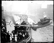
In 1915, the Eastland, an excursion boat docked at the Clark Street bridge, rolled over, killing 844 passengers. Many of the passengers were trapped by moving objects such as pianos and tables. The site is now the location of a memorial which was dedicated in 1989. The marker was stolen in 2000 and replaced in 2003. There are plans to build an outdoor exhibit at the site as well.
occurred when a pile driven into the riverbed caused stress fractures in the wall of a long-abandoned tunnel of the Chicago Tunnel Company
near the Kinzie Street railroad bridge
. Most of the 60 miles (96.6 km) network of underground freight railway, which encompasses much of downtown, was eventually flooded, along with the lower levels of buildings it once serviced and attached underground shops and pedestrian ways.
 The first bridge across the Chicago River was constructed over the north branch near the present day Kinzie Street in 1832. A second bridge, over the south branch near Randolph Street, was added in 1833. The first moveable bridge
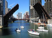
was constructed across the main stem at Dearborn Street in 1834. Today, the Chicago River has 38 movable bridges spanning it, down from a peak of 52 bridges. These bridges are of several different types, including trunnion bascule
, scherzer rolling lift, swing bridge
s, and vertical lift bridges.
and smallmouth bass
, rock bass
, crappie
, bluegill
, catfish
, and carp
. The river also has a large population of crayfish
. The South Fork of the Main (South) Branch, which was the primary sewer for the Union Stock Yards
and the meat packing industry
, was once so polluted that it became known as Bubbly Creek
. Illinois has issued advisories regarding eating fish from the river due to PCB
and mercury
contamination, including a "do not eat" advisory for carp more than 12 inches long. There are concerns that silver carp
and bighead carp
, now invasive species
in the Mississippi and Illinois River
s, may reach the Great Lakes
through the Chicago River. Despite the pollution concerns, the Chicago River remains a very popular target for freshwater recreational fishing. In 2006, the Chicago Park District started the annual "Mayor Daley's Chicago River Fishing Festival", which has increased in popularity with each year.
 As part of a more than forty year old Chicago tradition, the Chicago River is dyed green in observance of St. Patrick's Day. The actual event does not necessarily occur on St. Patrick's Day and is scheduled for the Saturday of the closest weekend. For example in 2009, the river was dyed on Saturday, March 14, 2009, whereas St. Patrick's day was on Tuesday, March 17, 2009.
Bill King, the administrator of Chicago's St. Patrick's Day committee, stated that "the idea of dyeing the Chicago River green originally came about by accident when a group of plumbers were using fluorescein
dye to trace illegal substances that were polluting the river". The dyeing of the river is still sponsored by the local plumbers union.
The United States Environmental Protection Agency
(EPA) outlawed the use of fluorescein
for this purpose, since it was proven to be harmful to the river. The ingredients used to dye the river green today are claimed to be safe and not harmful to the thousands of living organisms that find a habitat in the Chicago River. Forty pounds of vegetable dye are used to color the river for the celebration.
In 2009, in keeping with the Chicago St. Patrick's Day tradition, at the request of First Lady Michelle Obama
, who is a Chicago native, the White House fountains were dyed green to celebrate St. Patrick's Day.
News
Chicago
Chicago is the largest city in the US state of Illinois. With nearly 2.7 million residents, it is the most populous city in the Midwestern United States and the third most populous in the US, after New York City and Los Angeles...
, including its center (the Chicago Loop
Chicago Loop
The Loop or Chicago Loop is one of 77 officially designated Chicago community areas located in the City of Chicago, Illinois. It is the historic commercial center of downtown Chicago...
). Though not especially long, the river is notable for being the reason why Chicago became an important location, as the link between
Chicago Portage
The Chicago Portage connects the watersheds and the navigable waterways of the Mississippi River and the Great Lakes. It crosses the continental divide that separates the Great Lakes and Gulf of St. Lawrence watersheds from the Gulf of Mexico watershed.Near Chicago, the St...
the Great Lakes
Great Lakes
The Great Lakes are a collection of freshwater lakes located in northeastern North America, on the Canada – United States border. Consisting of Lakes Superior, Michigan, Huron, Erie, and Ontario, they form the largest group of freshwater lakes on Earth by total surface, coming in second by volume...
and the Mississippi Valley waterways. In the 19th century through civil engineering
Civil engineering
Civil engineering is a professional engineering discipline that deals with the design, construction, and maintenance of the physical and naturally built environment, including works like roads, bridges, canals, dams, and buildings...
, the flow of the river was reversed to head toward the Mississippi River
Mississippi River
The Mississippi River is the largest river system in North America. Flowing entirely in the United States, this river rises in western Minnesota and meanders slowly southwards for to the Mississippi River Delta at the Gulf of Mexico. With its many tributaries, the Mississippi's watershed drains...
basin, away from Lake Michigan
Lake Michigan
Lake Michigan is one of the five Great Lakes of North America and the only one located entirely within the United States. It is the second largest of the Great Lakes by volume and the third largest by surface area, after Lake Superior and Lake Huron...
, into which it previously emptied. This was done for reasons of sanitation. The river is also noted for the local custom of dyeing it green on St. Patrick's Day.
The river is memorialized, in part, by two horizontal blue stripes on the Municipal Flag of Chicago. The river also serves as inspiration for one of Chicago's ubiquitous symbols: a three-branched, Y-shaped symbol (called the municipal device) is found on many buildings and other structures throughout Chicago; it represents the three branches of the Chicago River.
Course
When it followed its natural course, the North and South Branches of the Chicago River converged at Wolf Point to form the Main Stem, which jogged southward from the present course of the river to avoid a baymouth barBaymouth bar
A baymouth bar is a depositional feature as a result of longshore drift. It is a spit that completely closes access to a bay, thus sealing it off from the main body of water. These bars usually consist of accumulated gravel and sand carried by the current of longshore drift and deposited at a less...
entering Lake Michigan at about the level of present day Madison Street
Madison Street (Chicago)
Madison Street is a major east-west street in Chicago, Illinois. Prior to human intervention, the Chicago River emptied into Lake Michigan at the present day intersection of Madison Street and Michigan Avenue....
. Today, the Main Stem of the Chicago River flows west from Lake Michigan to Wolf Point, where it converges with the North Branch to form the South Branch, which flows south west and empties into the Chicago Sanitary and Ship Canal
Chicago Sanitary and Ship Canal
The Chicago Sanitary and Ship Canal, historically known as the Chicago Drainage Canal, is the only shipping link between the Great Lakes and the Mississippi River system, by way of the Illinois and Des Plaines Rivers...
.
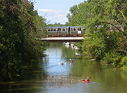
North Branch
Early settlers named the North Branch of the Chicago River the Guarie River, or Gary's River, after a trader who may have settled west bank of the river a short distance north of Wolf Point, at what is now Fulton Street. The source of the North Branch is in the northern suburbs of Chicago where its three principal tributaries converge. The Skokie RiverSkokie River
The Skokie River is a river that flows through the northern suburbs of Chicago, Illinois. It flows almost parallel to the shore of Lake Michigan, and historically discharged its outflow into that lake via the Chicago River...
—or East Fork—rises from a flat area, historically a wetland, near Park City, Illinois
Park City, Illinois
Park City is a small community located in the Warren and Waukegan townships of Lake County, Illinois, United States. The population was 6,637 at the 2000 census, broken up into three wards....
to the west of the city of Waukegan
Waukegan, Illinois
Waukegan is a city and county seat of Lake County, Illinois. As of the 2000 census, the city had a total population of 87,901. The 2010 population was 89,078. It is the ninth-largest city in Illinois by population...
.It then flows southward, paralleling the edge of Lake Michigan, through wetlands, the Greenbelt Forest Preserve and a number of golf courses towards Highland Park, Illinois
Highland Park, Illinois
Highland Park is a suburban municipality in Lake County, Illinois, United States, about north of downtown Chicago. As of 2009, the population is 33,492. Highland Park is one of several municipalities located on the North Shore of the Chicago Metropolitan Area.-Overview:Highland Park was founded...
. South of Highland Park the river passes the Chicago Botanic Gardens and though an area of former marshlands known as the Skokie Lagoons
Skokie Lagoons
Skokie Lagoons is a nature preserve in Glencoe and Winnetka, Illinois, owned and managed by the Forest Preserve District of Cook County. The park is bordered by Dundee Road to the north, Forestway Drive to the east, Willow Road to the south, and the Edens Expressway to the west. Within the park,...
. The Middle Fork arises near Rondout, Illinois and flows southwards through Lake Forest
Lake Forest, Illinois
Lake Forest is an affluent city located in Lake County, Illinois, United States. The city is south of Waukegan along the shore of Lake Michigan, and is a part of the Chicago metropolitan area and the North Shore. Lake Forest was founded around Lake Forest College and was laid out as a town in...
and Highland Park. These two tributaries merge at Watersmeet Woods west of Wilmette
Wilmette, Illinois
Wilmette is a village in New Trier Township, Cook County, Illinois, United States. It is located north of Chicago's downtown district and has a population of 27,651. Wilmette is considered a bedroom community in the North Shore district...
, from there the North Branch flows south towards Morton Grove
Morton Grove, Illinois
Morton Grove is a village in Cook County, Illinois, United States. The population was 22,451 at the 2000 census.The Village President of Morton Grove since April 27, 2009, is Daniel J...
. The West Fork rises near Mettawa
Mettawa, Illinois
Mettawa is a village in Lake County, Illinois, United States dedicated to preserving open lands and low-density residential development. The village maintains trails for pedestrian, bicycle and equestrian usage...
and flows south through Bannockburn
Bannockburn, Illinois
Bannockburn is a village in West Deerfield and Vernon townships of Lake County, Illinois, United States. The population was 1,429 at the 2000 census...
, Deerfield
Deerfield, Illinois
Deerfield is a village in Lake County, Illinois, United States and is located approximately 25 miles north of Chicago, Illinois. A portion of the village is in Cook County, Illinois, United States...
, and Northbrook
Northbrook, Illinois
Northbrook is a village located at the northern edge of Cook County, Illinois, which is also a North Shore suburb of Chicago. The population was 33,170 at the 2010 census....
, meeting the North Branch at Morton Grove.
Niles, Illinois
Niles is a village in Maine and Niles Townships, Cook County, Illinois, United States. The 2010 population from the U.S. Census Bureau is 29,803.The current mayor of Niles is Robert M. Callero.-History:Niles was first settled in 1827....
, entering the city of Chicago near the intersection of Milwaukee Avenue
Milwaukee Avenue (Chicago)
Milwaukee Avenue is a major diagonal street in the city of Chicago and the northern suburbs. True to its name, it once led to the city of Milwaukee, Wisconsin. Starting with a short section at N. Canal and W. Lake Streets, it begins in earnest at the corner of N Desplaines and W. Kinzie Streets...
and Devon Avenue
Devon Avenue (Chicago)
Devon Avenue is a major east-west thoroughfare in the Chicago metropolitan area. It begins at Chicago's Sheridan Road, which borders Lake Michigan, and it runs west until merging with Higgins Road near O'Hare International Airport. Devon continues on the opposite side of the airport and runs...
, from where it serves as the boundary of the Forest Glen
Forest Glen, Chicago
Forest Glen is one of the 77 community areas of Chicago, Illinois, located in the city's Northwest Side.-Edgebrook:Edgebrook borders the neighborhood of Sauganash. Edgebrook was once part of the Sauganash land tract and was annexed by the city of Chicago in 1889. To the north of Edgebrook lie...
community area with Norwood Park
Norwood Park, Chicago
Norwood Park is one of 77 well-defined Chicago, Illinois community areas. It encompasses the smaller neighborhoods of Big Oaks, Norwood Park East, Norwood Park West, Old Norwood Park, Oriole Park, and Union Ridge....
and Jefferson Park
Jefferson Park, Chicago
Jefferson Park is one of Chicago's 77 well-defined community areas located on the city's Northwest Side. The neighborhood of Jefferson Park occupies a larger swath of territory than the community area by including within it land of adjacent community areas...
. On this stretch of the river it meanders in a south-easterly direction, passing through golf courses and forest preserves
Cook County Forest Preserves
The Cook County Forest Preserves are a network of open spaces, containing forest, prairie, wetland, streams, and lakes, that are set aside as natural areas. Cook County contains Chicago, Illinois, and is the center of a densely-populated urban metropolitan area in northeastern Illinois...
until it reaches Foster Avenue
Foster Avenue (Chicago)
Foster Avenue is a major east-west street on the North Side of Chicago as well as the northwestern suburbs. Foster Avenue separates the Chicago lakefront neighborhoods of Edgewater to the north and Uptown to the south....
, where it passes through residential neighborhoods on the north side of the Albany Park
Albany Park, Chicago
Albany Park is one of 77 well-defined Chicago, Illinois, community areas on the Northwest Side of the City of Chicago. It includes the Albany Park neighborhood, one of the most ethnically diverse in the United States...
community area. In West River Park the river meets the North Shore Channel
North Shore Channel
The North Shore Channel is a drainage canal built between 1907 and 1910 to flush the sewage-filled North Branch of the Chicago River down the Chicago Sanitary and Ship Canal...
, a drainage canal built between 1907 and 1910 to increase the flow of the North Branch and help flush pollution into the Chicago Sanitary and Ship Canal
Chicago Sanitary and Ship Canal
The Chicago Sanitary and Ship Canal, historically known as the Chicago Drainage Canal, is the only shipping link between the Great Lakes and the Mississippi River system, by way of the Illinois and Des Plaines Rivers...
. From the confluence with the North Shore Channel south to Belmont Avenue the North Branch flows through mostly residential neighborhoods in a man-made channel that was dug to straighten and deepen the river, helping it to carry the additional flow from the North Shore Channel.
South of Belmont the North Branch is lined with a mixture of residential developments, retail parks, and industry until it reaches the industrial area known as the Clybourn Corridor. Here is passes beneath the Cortland Street Drawbridge
Cortland Street Drawbridge
The Cortland Street Drawbridge over the Chicago River is the original Chicago-style fixed-trunnion bascule bridge, designed by John Ericson and Edward Wilmann. When it opened in 1902 on the north side of Chicago, it was the first such bridge built in the United States...
, which was the first 'Chicago-style' fixed-trunnion bascule bridge
Bascule bridge
A bascule bridge is a moveable bridge with a counterweight that continuously balances the span, or "leaf," throughout the entire upward swing in providing clearance for boat traffic....
built in the United States
United States
The United States of America is a federal constitutional republic comprising fifty states and a federal district...
, and is designated as an ASCE
American Society of Civil Engineers
The American Society of Civil Engineers is a professional body founded in 1852 to represent members of the civil engineering profession worldwide. It is the oldest national engineering society in the United States. ASCE's vision is to have engineers positioned as global leaders who strive toward...
Civil Engineering Landmark and a Chicago Landmark
Chicago Landmark
Chicago Landmark is a designation of the Mayor of Chicago and the Chicago City Council for historic buildings and other sites in Chicago, Illinois, United States. Listed sites are selected after meeting a combination of criteria, including historical, economic, architectural, artistic, cultural,...
.
At North Avenue, south of the North Avenue Bridge
North Avenue Bridge
The North Avenue Bridge can refer to one of three bridges that has carried North Avenue over the North Branch of the Chicago River on the north side of Chicago, Illinois...
, the North Branch divides, the original course of the river makes a curve along the west side of Goose Island
Goose Island (Chicago)
Goose Island is the only island on the Chicago River in Illinois. It is an artificial island, formed by the North Branch of the Chicago River on the west and the North Branch Canal on the east...
, whilst the North Branch Canal cuts off the bend, forming the island. The North Branch Canal—or Ogden's Canal—was completed in 1857, and was originally 50 feet (15.2 m) wide and 10 feet (3 m) deep allowing craft navigating the river to avoid the bend. The 1902 Cherry Avenue Bridge
Cherry Avenue Bridge
The Cherry Avenue Bridge is an asymmetric bob-tail swing bridge in Chicago, Illinois that carries the Chicago Terminal Railroad, pedestrians, and cyclists across the North Branch Canal of the Chicago River. It was constructed in 1901–02 by the Chicago, Milwaukee and St...
, just south of North Avenue, was constructed to carry the Chicago, Milwaukee and St. Paul Railway onto Goose Island. It is rare example of an asymmetric bob-tail swing bridge and was designated a Chicago Landmark in 2007. From Goose Island the North Branch continues to flow south east to Wolf Point where it joins the Main Stem.
Main Stem
velocity meters at the Columbus Drive Bridge and the T.J. O'Brien lock on the Calumet River
Calumet River
The Calumet River refers to a system of heavily industrialized rivers and canals in the region between the neighborhood of South Chicago in Chicago, Illinois, and the city of Gary, Indiana.-Background:...
monitor the diversion of water from Lake Michigan to the Mississippi River basin, which is limited to an average of 3200 cubic feet (90.6 m³) per second per year over the 40 year period from 1980 to 2020.
The Main Stem flows 1.5 miles (2.4 km) west from the controlling works at Lake Michigan; passing beneath the Outer Drive
Outer Drive Bridge
The Outer Drive Bridge, also known as the Link Bridge was started in 1929 and completed in 1937 as part of Ickes’s Public Works Administration in Chicago. It was planned by the Chicago Plan Commission, using Hugh E...
, Columbus Drive, Michigan Avenue
Michigan Avenue Bridge
The Michigan Avenue Bridge has a north–south orientation, spanning the main stem of the Chicago River between the Near North Side and Loop community areas of Chicago. Its northern portal lies at the foot of the Magnificent Mile, between the Wrigley Building and Tribune Tower...
, Wabash Avenue
Wabash Avenue Bridge
The Wabash Avenue Bridge over the Chicago River was built in 1930. Standing west of the Michigan Avenue Bridge and southwest of the Trump International Hotel and Tower, the bascule bridge connects the Near North Side with "The Loop" area.The single-deck, double leaf bridge was designed by Thomas...
, State Street, Dearborn Street
Dearborn Street Bridge
The Dearborn Street Bridge over the Chicago River was built in 1962. It connects the Near North Side with "The Loop." The American Institute of Steel Construction honored the bridge with the 1963 "Most Beautiful Steel Bridge" award in the Movable Span category....
, Clark Street
Clark Street Bridge
The Clark Street Bridge is a bascule bridge that spans the Chicago River in downtown Chicago, connecting the Near North Side with The Loop.-History:...
, La Salle Street
La Salle Street Bridge
The La Salle Street Bridge is a single-deck double-leaf trunnion bascule bridge spanning the main stem of the Chicago River in Chicago, Illinois, that connects the Near North Side with the Loop area...
, Wells Street, and Franklin Street
Franklin Street Bridge
The Franklin–Orleans Street Bridge over the Chicago River was built in October 1920, directly southwest of the Merchandise Mart. Connecting the Near North Side with "The Loop," is at the junction of the branches of the river, lying directly west of the Wells Street Bridge...
bridges en route to its confluence with the North Branch at Wolf Point. At McClurg Court it passes the Nicholas J Melas Centennial Fountain
Centennial Fountain
Nicholas J Melas Centennial Fountain is located on the north bank of the Chicago River at McClurg Court in Near North Side, Chicago. It was dedicated in 1989, to celebrate the 100th anniversary of the Metropolitan Water Reclamation District of Greater Chicago, perhaps best known for its major...
, which was built in 1989 to celebrate the 100th anniversary of the Metropolitan Water Reclamation District of Greater Chicago
Metropolitan Water Reclamation District of Greater Chicago
The Metropolitan Water Reclamation District of Greater Chicago , originally known as the Sanitary District of Chicago is a special-purpose district, chartered to operate in northern Illinois since 1889...
; between May and October the fountain sends an arc of water over the river for ten minutes every hour. On the north bank of the river, near the Chicago Landmark Michigan Avenue Bridge, is Pioneer Court
Pioneer Court
Pioneer Court is a plaza located near the junction of the Chicago River and Upper Michigan Avenue in Chicago's Magnificent Mile. It is believed to be the site of Jean Baptiste Point du Sable's original residence and trading post. In 1965, the plaza was built on the former site of his homestead as...
, which marks the site of the homestead of Jean Baptiste Point du Sable who is recognized as the founder of Chicago. On the south bank of the river is the site of Fort Dearborn
Fort Dearborn
Fort Dearborn was a United States fort built in 1803 beside the Chicago River in what is now Chicago, Illinois. It was constructed by troops under Captain John Whistler and named in honor of Henry Dearborn, then United States Secretary of War. The original fort was destroyed following the Battle of...
. Notable buildings surrounding this area include the NBC Tower
NBC Tower
The NBC Tower is an office tower on the Near north side of Chicago, Illinois, United States located at 454 North Columbus Drive in downtown Chicago's Magnificent Mile area. Completed in 1989, the 37-story building reaches a height of 627 feet...
, the Tribune Tower
Tribune Tower
The Tribune Tower is a neo-Gothic building located at 435 North Michigan Avenue in Chicago, Illinois. It is the home of the Chicago Tribune and Tribune Company. WGN Radio also broadcasts from the building, with ground-level studios overlooking nearby Pioneer Court and Michigan Avenue. CNN's...
, and the Wrigley Building
Wrigley Building
The Wrigley Building is a skyscraper located directly across Michigan Avenue from the Tribune Tower on the Magnificent Mile...
. The river turns slightly to the south west between Michigan Avenue and State Street, passing the Trump International Hotel and Tower
Trump International Hotel and Tower (Chicago)
The Trump International Hotel and Tower, also known as Trump Tower Chicago and locally as the Trump Tower, is a skyscraper condo-hotel in downtown Chicago, Illinois. The building, named after real estate developer Donald Trump, was designed by architect Adrian Smith of Skidmore, Owings and Merrill...
, 35 East Wacker
35 East Wacker
__notoc__35 East Wacker, also known as the Jewelers' Building, is a 40-story historic building in the Loop community area of Chicago, Illinois, located at the intersections of Wabash Avenue, and facing the Chicago River. It was built from 1925 to 1927, and was co-designed by Joachim G. Giaver and...
, and 330 North Wabash. Turning west again the river passes Marina City
Marina City
Marina City is a mixed-use residential/commercial building complex occupying an entire city block on State Street in Chicago, Illinois. It lies on the north bank of the Chicago River in downtown Chicago, directly across from the Loop district...
, the Reid, Murdoch & Co. Building
Reid, Murdoch & Co. Building
The Reid, Murdoch & Co. Building, also known as the Reid Murdoch Building, the Reid Murdoch Center or the City of Chicago Central Office Building, is a seven story office building in Chicago. It was constructed in 1914 and was listed on the National Register of Historic Places in 1975. It also has...
, and Merchandise Mart
Merchandise Mart
When opened in 1930, the Merchandise Mart or the Merch Mart, located in the Near North Side, Chicago, Illinois, was the largest building in the world with of floor space. Previously owned by the Marshall Field family, the Mart centralized Chicago's wholesale goods business by consolidating vendors...
, and 333 Wacker Drive
333 Wacker Drive
333 West Wacker Drive is a highrise office building in Chicago, Illinois. On the side facing the Chicago River, the building features a curved green glass façade, while on the other side the building adheres to the usual rectangular street grid...
.
South Branch
The source of the South Branch of the Chicago River is the confluence of the North Branch and Main stem at Wolf Point. From here the river flows south passing the Lake Street, Randolph Street, Washington Street, Madison Street, Monroe Street, Adams Street, Jackson Boulevard, Van Buren Street, Congress Parkway, and Harrison Street bridges before leaving the downtown Loop community area. Notable buildings that line this stretch of the river include the BoeingBoeing
The Boeing Company is an American multinational aerospace and defense corporation, founded in 1916 by William E. Boeing in Seattle, Washington. Boeing has expanded over the years, merging with McDonnell Douglas in 1997. Boeing Corporate headquarters has been in Chicago, Illinois since 2001...
Company World Headquarters, the Civic Opera House
Civic Opera House (Chicago)
The Civic Opera House is an opera house located at 20 North Wacker Drive in Chicago. It is part of a building which contains a 45-story office tower and two 22-story wings. This structure opened on November 4, 1929 and has an Art Deco interior....
, the Chicago Mercantile Exchange
Chicago Mercantile Exchange
The Chicago Mercantile Exchange is an American financial and commodity derivative exchange based in Chicago. The CME was founded in 1898 as the Chicago Butter and Egg Board. Originally, the exchange was a non-profit organization...
, and Union Station
Union Station (Chicago)
Union Station is a major train station that opened in 1925 in Chicago, replacing an earlier 1881 station. It is now the only intercity rail terminal in Chicago, as well as being the city's primary terminal for commuter trains. The station stands on the west side of the Chicago River between Adams...
.
The river continues southwards past railroad yards. Between Polk and 18th Streets the river originally made a meander to the east; between 1927 and 1929 the river was straightened and moved 1/4 mi west at this point to make room for a railroad terminal. The river turns to the south west at Ping Tom Memorial Park
Ping Tom Memorial Park
Ping Tom Memorial Park is a public urban park in Chicago's Chinatown owned and operated by the Chicago Park District . Located on the south bank of the Chicago River, the park is divided into three sections by a Santa Fe rail track and 18th Street. Currently, only development in the area south of...
where it passes under the Chicago Landmark Canal Street railroad bridge
Canal Street railroad bridge
The Canal Street railroad bridge is a vertical lift bridge across the south branch of the Chicago River in Chicago, Illinois. When it was constructed in 1914 its 1500 ton main span was the heaviest of any vertical lift bridge in the United States...
. The river turns westward where it is crossed by the Dan Ryan Expressway
Dan Ryan Expressway
The Dan Ryan is an expressway in the city of Chicago that runs from the Circle Interchange with I-290 near downtown Chicago through the South Side of the city. It is designated as both Interstate 94 and Interstate 90 south to 66th Street, a distance of...
; these immovable bridges have a clearance of 60 feet (18.3 m) requiring large ships that pass underneath to have folding masts.
At Ashland Avenue the river widens to form the U.S. Turning Basin, the west bank of which was the starting point of the Illinois and Michigan Canal
Illinois and Michigan Canal
The Illinois and Michigan Canal ran from the Bridgeport neighborhood in Chicago on the Chicago River to LaSalle-Peru, Illinois, on the Illinois River. It was finished in 1848 when Chicago Mayor James Hutchinson Woodworth presided over its opening; and it allowed boat transportation from the Great...
.. At the basin the river is joined by a tributary, the South Fork of the river, which is commonly given the nickname Bubbly Creek
Bubbly Creek
Bubbly Creek is the nickname given to the South Fork of the Chicago River's South Branch, which runs entirely within the city of Chicago, Illinois. Gases bubbling out of the riverbed from the decomposition of blood and entrails dumped into the river by the local stockyards in the early 20th...
. A bridge used to span the South Fork at this point that was too low for boats to pass meaning that their cargo needed to be unloaded at the bridge, and the surrounding neighborhood became known as Bridgeport
Bridgeport, Chicago
Bridgeport, one of 77 community areas of Chicago, is a neighborhood located on the city's South Side. It is bounded, generally, on the west and north by the Chicago River, on the east by Canal Street, and on the south by Pershing Road.-History:...
. The river continues to the south west, entering the Chicago Sanitary and Ship Canal
Chicago Sanitary and Ship Canal
The Chicago Sanitary and Ship Canal, historically known as the Chicago Drainage Canal, is the only shipping link between the Great Lakes and the Mississippi River system, by way of the Illinois and Des Plaines Rivers...
at Damen Avenue. The original West Fork of the South Branch has been filled in; a triangular intrusion into the north bank at Damen Avenue marks the place where it diverged from the course of the canal. From the canal, the water flows into the Des Plaines River
Des Plaines River
The Des Plaines River is a river that flows southward for through southern Wisconsin and northern Illinois in the U.S. Midwest, eventually meeting the Kankakee River west of Channahon to form the Illinois River, a tributary of the Mississippi River....
and eventually reaches the Gulf of Mexico
Gulf of Mexico
The Gulf of Mexico is a partially landlocked ocean basin largely surrounded by the North American continent and the island of Cuba. It is bounded on the northeast, north and northwest by the Gulf Coast of the United States, on the southwest and south by Mexico, and on the southeast by Cuba. In...
.
Discharge
The United States Geological SurveyUnited States Geological Survey
The United States Geological Survey is a scientific agency of the United States government. The scientists of the USGS study the landscape of the United States, its natural resources, and the natural hazards that threaten it. The organization has four major science disciplines, concerning biology,...
monitors water flow at a number of sites in the Chicago River system. Discharge from the North Branch is measured at Grand Avenue; between 2004 and 2010 this averaged 582 cubic feet (16.5 m³) per second. During the winter months as much as 75% of the flow in the North Branch is due to the discharge of treated sewage from the North Side Water Reclamation Plant into the North Shore Channel. Flow on the Main Stem is measured at Columbus Drive; between 2000 and 2006 this averaged 136 cubic feet (3.9 m³) per second.
Early non-Native American settlers
Louis JollietLouis Jolliet
Louis Jolliet , also known as Louis Joliet, was a French Canadian explorer known for his discoveries in North America...
and Jacques Marquette
Jacques Marquette
Father Jacques Marquette S.J. , sometimes known as Père Marquette, was a French Jesuit missionary who founded Michigan's first European settlement, Sault Ste. Marie, and later founded St. Ignace, Michigan...
, though probably not the first Europeans to visit the area, are the first recorded to have visited the Chicago River in 1673, when they wrote of their discovery of the geographically vital Chicago Portage
Chicago Portage
The Chicago Portage connects the watersheds and the navigable waterways of the Mississippi River and the Great Lakes. It crosses the continental divide that separates the Great Lakes and Gulf of St. Lawrence watersheds from the Gulf of Mexico watershed.Near Chicago, the St...
. Marquette returned in 1674, camped a few days near the mouth of the river, then moved on to the Chicago River–Des Plaines River
Des Plaines River
The Des Plaines River is a river that flows southward for through southern Wisconsin and northern Illinois in the U.S. Midwest, eventually meeting the Kankakee River west of Channahon to form the Illinois River, a tributary of the Mississippi River....
portage
Portage
Portage or portaging refers to the practice of carrying watercraft or cargo over land to avoid river obstacles, or between two bodies of water. A place where this carrying occurs is also called a portage; a person doing the carrying is called a porter.The English word portage is derived from the...
, where he stayed through the winter of 1674–75. The Fox Wars
Fox Wars
The Fox Wars were two 18th-century wars between the Fox Indians and the French , which occurred in territories that are now the states of Michigan and Wisconsin, U.S.A.. The First Fox War broke out with the French when the Fox numbered some 3,500. After the Second Fox War , the remaining 1,500...
effectively closed the Chicago area to Europeans in the first part of the 18th century. The first non-native to re-settle in the area may have been a trader named Guillory, who might have had a trading-post near Wolf Point
Wolf Point, Chicago
Wolf Point is the location at the confluence of the North, South and Main Branches of the Chicago River in the present day Near North Side, Loop, and Near West Side community areas of Chicago. This fork in the river is historically important in the development of early Chicago...
on the Chicago River in around 1778. In 1823 a government expedition used the name Gary River (phonetic spelling of Guillory) to refer to the north branch of the Chicago River.
Jean Baptiste Point du Sable is widely regarded as the first permanent resident of Chicago; he built a farm on the northern bank at the mouth of the river in the 1780s. The earliest known record of Pointe du Sable living in Chicago is the diary of Hugh Heward, who made a journey through Illinois in the spring of 1790. Antoine Ouilmette
Antoine Ouilmette
Antoine Ouilmette was a fur trader and early resident of what is now Chicago, Illinois. He was of French Canadian and possibly Native American ancestry. The village of Wilmette, Illinois is named in his honor....
claimed to have arrived in Chicago shortly after this in July of 1790. In 1803, Fort Dearborn
Fort Dearborn
Fort Dearborn was a United States fort built in 1803 beside the Chicago River in what is now Chicago, Illinois. It was constructed by troops under Captain John Whistler and named in honor of Henry Dearborn, then United States Secretary of War. The original fort was destroyed following the Battle of...
was constructed on the opposite bank on the site of the present-day Michigan Avenue Bridge
Michigan Avenue Bridge
The Michigan Avenue Bridge has a north–south orientation, spanning the main stem of the Chicago River between the Near North Side and Loop community areas of Chicago. Its northern portal lies at the foot of the Magnificent Mile, between the Wrigley Building and Tribune Tower...
. Lieutenant James Strode Swearingen, who led the troops from Detroit to Chicago to establish the fort, described the river as being about 30 yards (27.4 m) wide and upwards of 18 feet (5.5 m) deep at the place where the fort was intended to be built; the riverbanks were 8 feet (2.4 m) high on the south side and 6 feet (1.8 m) on the north.
Early improvements
Between 1816 and 1828 soldiers from Fort Dearborn cut channels through the sandbar at the mouth of the river to allow yawlYawl
A yawl is a two-masted sailing craft similar to a sloop or cutter but with an additional mast located well aft of the main mast, often right on the transom, specifically aft of the rudder post. A yawl (from Dutch Jol) is a two-masted sailing craft similar to a sloop or cutter but with an...
s to bring supplies to the fort. These channels rapidly clogged with sand requiring a new one to be cut. On March 2, 1833 $25,000 was appropriated by Congress for harbor works, and work began in June of that year under the supervision of Major George Bender, the commandant at Fort Dearborn. In January 1834 James Allen took over the supervision of this work and, aided by a February storm that breached the sandbar, on July 12, 1834 the harbor works had progressed enough to allow a 100 short tons (90.7 t) schooner, the Illinois to sail up the river to Wolf Point and dock at the wharf of Newberry & Dole. The initial entrance through the sandbar was 200 feet (61 m) wide and 3 to 7 ft (0.9144 to 2.1 m) deep, flanked by piers 200 feet (61 m) long on the south wall and 700 feet (213.4 m) long to the north. Allen's work continued, and by October 1837 the still unfinished piers had been extended to 1850 feet (563.9 m) and 1200 feet (365.8 m) respectively.
In 1848, the Illinois and Michigan canal
Illinois and Michigan Canal
The Illinois and Michigan Canal ran from the Bridgeport neighborhood in Chicago on the Chicago River to LaSalle-Peru, Illinois, on the Illinois River. It was finished in 1848 when Chicago Mayor James Hutchinson Woodworth presided over its opening; and it allowed boat transportation from the Great...
linked the river to the Illinois River
Illinois River
The Illinois River is a principal tributary of the Mississippi River, approximately long, in the State of Illinois. The river drains a large section of central Illinois, with a drainage basin of . This river was important among Native Americans and early French traders as the principal water route...
and the Mississippi Valley across the Chicago Portage
Chicago Portage
The Chicago Portage connects the watersheds and the navigable waterways of the Mississippi River and the Great Lakes. It crosses the continental divide that separates the Great Lakes and Gulf of St. Lawrence watersheds from the Gulf of Mexico watershed.Near Chicago, the St...
.
In 1900, the river's flow was reversed in order to keep Lake Michigan clean.
Reversing the flow
During the last ice age, the area that became Chicago was covered by Lake ChicagoLake Chicago
This article is about the prehistoric lake, For other geographic features with this name, see ChicagoLake Chicago was a prehistoric proglacial lake that is the ancestor of what is now known as Lake Michigan, one of North America's five Great Lakes....
, which drained south into the Mississippi Valley. As the ice and water retreated, a short 12 to 14 feet (4.3 m) ridge was exposed about a mile inland which generally separated the Great Lake's watershed from the Mississippi Valley, except in times of heavy precipitation or when winter ice flows prevented drainage. By the time Europeans arrived, the Chicago River flowed sluggishly into Lake Michigan from Chicago's flat plain. As Chicago grew, this allowed sewage and other pollution into the clean-water source for the city, contributing to several public health
Public health
Public health is "the science and art of preventing disease, prolonging life and promoting health through the organized efforts and informed choices of society, organizations, public and private, communities and individuals" . It is concerned with threats to health based on population health...
problems, like typhoid fever
Typhoid fever
Typhoid fever, also known as Typhoid, is a common worldwide bacterial disease, transmitted by the ingestion of food or water contaminated with the feces of an infected person, which contain the bacterium Salmonella enterica, serovar Typhi...
. Starting in 1848, much of the Chicago River's flow was also diverted across the Chicago Portage
Chicago Portage
The Chicago Portage connects the watersheds and the navigable waterways of the Mississippi River and the Great Lakes. It crosses the continental divide that separates the Great Lakes and Gulf of St. Lawrence watersheds from the Gulf of Mexico watershed.Near Chicago, the St...
into the Illinois and Michigan Canal
Illinois and Michigan Canal
The Illinois and Michigan Canal ran from the Bridgeport neighborhood in Chicago on the Chicago River to LaSalle-Peru, Illinois, on the Illinois River. It was finished in 1848 when Chicago Mayor James Hutchinson Woodworth presided over its opening; and it allowed boat transportation from the Great...
. In 1871, the old canal was deepened in an attempt to completely reverse the river's flow but the reversal of the river only lasted one season.
Finally, in 1900, the Sanitary District of Chicago
Metropolitan Water Reclamation District of Greater Chicago
The Metropolitan Water Reclamation District of Greater Chicago , originally known as the Sanitary District of Chicago is a special-purpose district, chartered to operate in northern Illinois since 1889...
, then headed by William Boldenweck, completely reversed the flow of the Main Stem and South Branch of the river using a series of canal locks, increasing the river's flow from Lake Michigan and causing it to empty into the newly completed Chicago Sanitary and Ship Canal
Chicago Sanitary and Ship Canal
The Chicago Sanitary and Ship Canal, historically known as the Chicago Drainage Canal, is the only shipping link between the Great Lakes and the Mississippi River system, by way of the Illinois and Des Plaines Rivers...
. In 1999, this system was named a 'Civil Engineering Monument of the Millennium' by the American Society of Civil Engineers
American Society of Civil Engineers
The American Society of Civil Engineers is a professional body founded in 1852 to represent members of the civil engineering profession worldwide. It is the oldest national engineering society in the United States. ASCE's vision is to have engineers positioned as global leaders who strive toward...
(ASCE). Before this time, the Chicago River was known by many local residents of Chicago as "the stinking river" because of the massive amounts of sewage
Sewage
Sewage is water-carried waste, in solution or suspension, that is intended to be removed from a community. Also known as wastewater, it is more than 99% water and is characterized by volume or rate of flow, physical condition, chemical constituents and the bacteriological organisms that it contains...
and pollution
Pollution
Pollution is the introduction of contaminants into a natural environment that causes instability, disorder, harm or discomfort to the ecosystem i.e. physical systems or living organisms. Pollution can take the form of chemical substances or energy, such as noise, heat or light...
which poured into the river from Chicago's booming industrial economy. Through the 1980s, the river was quite dirty and often filled with garbage
Waste
Waste is unwanted or useless materials. In biology, waste is any of the many unwanted substances or toxins that are expelled from living organisms, metabolic waste; such as urea, sweat or feces. Litter is waste which has been disposed of improperly...
; however, during the 1990s, it underwent extensive cleaning as part of an effort at beautification by Chicago Mayor Richard M. Daley
Richard M. Daley
Richard Michael Daley is a United States politician, member of the national and local Democratic Party, and former Mayor of Chicago, Illinois. He was elected mayor in 1989 and reelected in 1991, 1995, 1999, 2003, and 2007. He was the longest serving Chicago mayor, surpassing the tenure of his...
.
In 2005, researchers at the University of Illinois at Urbana-Champaign
University of Illinois at Urbana-Champaign
The University of Illinois at Urbana–Champaign is a large public research-intensive university in the state of Illinois, United States. It is the flagship campus of the University of Illinois system...
created a three-dimensional, hydrodynamic simulation of the Chicago River, which suggested that density currents are the cause of an observed bi-directional wintertime flow in the river. At the surface, the river flows east to west, away from Lake Michigan, as expected. But deep below, near the riverbed, water travels, seasonally, west to east, toward the lake.
All outflows from the Great Lakes Basin
Great Lakes Basin
The Great Lakes Basin consists of the Great Lakes and the surrounding lands of the states of Illinois, Indiana, Michigan, Minnesota, New York, Ohio, Pennsylvania, and Wisconsin in the United States, and the province of Ontario in Canada, whose direct surface runoff and watersheds form a large...
are regulated by the joint U.S.-Canadian Great Lakes Commission
Great Lakes Commission
The Great Lakes Commission is a United States interstate agency established in 1955 through the Great Lakes Compact, in order to "promote the orderly, integrated and comprehensive development, use and conservation of the water resources of the Great Lakes Basin," which includes the Saint Lawrence...
, and the outflow through the Chicago River is set under a U.S. Supreme Court
Supreme Court of the United States
The Supreme Court of the United States is the highest court in the United States. It has ultimate appellate jurisdiction over all state and federal courts, and original jurisdiction over a small range of cases...
decision (1967, modified 1980 and 1997). The city of Chicago is allowed to remove 3200 cubic feet per second (91 m³/s) of water from the Great Lakes system; about half of this, 1 billion US gallons a day (44 m³/s), is sent down the Chicago River, while the rest is used for drinking water. In late 2005, the Chicago-based Alliance for the Great Lakes
Alliance for the Great Lakes
The Alliance for the Great Lakes was originally founded in 1970 by Lee Botts as the Lake Michigan Federation, which Botts had established a year earlier as a project of The Openlands Project in Chicago. The purpose of the Lake Michigan Federation was to promote awareness and policy to protect and...
proposed re-separating the Great Lakes and Mississippi River basins to address such ecological concerns as the spread of invasive species
Invasive species
"Invasive species", or invasive exotics, is a nomenclature term and categorization phrase used for flora and fauna, and for specific restoration-preservation processes in native habitats, with several definitions....
.
Eastland disaster
In 1915, the Eastland, an excursion boat docked at the Clark Street bridge, rolled over, killing 844 passengers. Many of the passengers were trapped by moving objects such as pianos and tables. The site is now the location of a memorial which was dedicated in 1989. The marker was stolen in 2000 and replaced in 2003. There are plans to build an outdoor exhibit at the site as well.
Chicago Flood
On April 13, 1992, the Chicago FloodChicago Flood
The Chicago Flood occurred on April 13, 1992, when the damaged wall of a utility tunnel beneath the Chicago River opened into a breach which flooded basements and underground facilities throughout the Chicago Loop with an estimated of water.-Cause:...
occurred when a pile driven into the riverbed caused stress fractures in the wall of a long-abandoned tunnel of the Chicago Tunnel Company
Chicago Tunnel Company
The Chicago Tunnel Company built a narrow gauge railway freight tunnel network under the downtown of the city of Chicago. This was regulated by the Interstate Commerce Commission as an interurban despite the fact that it operated entirely under central Chicago, did not carry passengers, and was...
near the Kinzie Street railroad bridge
Kinzie Street railroad bridge
The Chicago and North Western Railway's Kinzie Street railroad bridge is a single leaf bascule bridge across the north branch of the Chicago River in downtown Chicago, Illinois. At the time of its opening in 1908 it was the world's longest and heaviest bascule bridge...
. Most of the 60 miles (96.6 km) network of underground freight railway, which encompasses much of downtown, was eventually flooded, along with the lower levels of buildings it once serviced and attached underground shops and pedestrian ways.
Bridges
Moveable bridge
A moveable bridge is a bridge that moves to allow passage for boats or barges. An advantage of making bridges movable include lower price, due to the absence of high piers and long approaches. The principal disadvantage is that the traffic on the bridge must be halted when it is opened for passages...
was constructed across the main stem at Dearborn Street in 1834. Today, the Chicago River has 38 movable bridges spanning it, down from a peak of 52 bridges. These bridges are of several different types, including trunnion bascule
Bascule bridge
A bascule bridge is a moveable bridge with a counterweight that continuously balances the span, or "leaf," throughout the entire upward swing in providing clearance for boat traffic....
, scherzer rolling lift, swing bridge
Swing bridge
A swing bridge is a movable bridge that has as its primary structural support a vertical locating pin and support ring, usually at or near to its centre of gravity, about which the turning span can then pivot horizontally as shown in the animated illustration to the right...
s, and vertical lift bridges.
Pollution
The Chicago River has been highly affected by industrial and residential development with attendant changes to the quality of the water and riverbanks. Several species of freshwater fish are known to inhabit the river, including largemouthLargemouth bass
The largemouth bass is a species of black bass in the sunfish family native to North America . It is also known as widemouth bass, bigmouth, black bass, bucketmouth, Potter's fish, Florida bass, Florida largemouth, green bass, green trout, linesides, Oswego bass, southern largemouth...
and smallmouth bass
Smallmouth bass
The smallmouth bass is a species of freshwater fish in the sunfish family of the order Perciformes. It is the type species of its genus...
, rock bass
Rock bass
The rock bass , also known as the rock perch, goggle-eye, or red eye is a species of freshwater fish in the sunfish family of order Perciformes. They are similar in appearance to smallmouth bass but are usually quite a bit smaller...
, crappie
Crappie
Crappie is a genus of freshwater fish in the sunfish family of order Perciformes. The type species is P. annularis, the white crappie...
, bluegill
Bluegill
The Bluegill is a species of freshwater fish sometimes referred to as bream, brim, or copper nose. It is a member of the sunfish family Centrarchidae of the order Perciformes.-Range and distribution:...
, catfish
Catfish
Catfishes are a diverse group of ray-finned fish. Named for their prominent barbels, which resemble a cat's whiskers, catfish range in size and behavior from the heaviest and longest, the Mekong giant catfish from Southeast Asia and the second longest, the wels catfish of Eurasia, to detritivores...
, and carp
Carp
Carp are various species of oily freshwater fish of the family Cyprinidae, a very large group of fish native to Europe and Asia. The cypriniformes are traditionally grouped with the Characiformes, Siluriformes and Gymnotiformes to create the superorder Ostariophysi, since these groups have certain...
. The river also has a large population of crayfish
Crayfish
Crayfish, crawfish, or crawdads – members of the superfamilies Astacoidea and Parastacoidea – are freshwater crustaceans resembling small lobsters, to which they are related...
. The South Fork of the Main (South) Branch, which was the primary sewer for the Union Stock Yards
Union Stock Yards
The Union Stock Yard & Transit Co., or The Yards, was the meat packing district in Chicago for over a century starting in 1865. The district was operated by a group of railroad companies that acquired swampland, and turned it to a centralized processing area...
and the meat packing industry
Meat packing industry
The meat packing industry handles the slaughtering, processing, packaging, and distribution of animals such as cattle, pigs, sheep and other livestock...
, was once so polluted that it became known as Bubbly Creek
Bubbly Creek
Bubbly Creek is the nickname given to the South Fork of the Chicago River's South Branch, which runs entirely within the city of Chicago, Illinois. Gases bubbling out of the riverbed from the decomposition of blood and entrails dumped into the river by the local stockyards in the early 20th...
. Illinois has issued advisories regarding eating fish from the river due to PCB
Polychlorinated biphenyl
Polychlorinated biphenyls are a class of organic compounds with 2 to 10 chlorine atoms attached to biphenyl, which is a molecule composed of two benzene rings. The chemical formula for PCBs is C12H10-xClx...
and mercury
Mercury (element)
Mercury is a chemical element with the symbol Hg and atomic number 80. It is also known as quicksilver or hydrargyrum...
contamination, including a "do not eat" advisory for carp more than 12 inches long. There are concerns that silver carp
Silver carp
The silver carp is a species of freshwater cyprinid fish, a variety of Asian carp native to north and northeast Asia. It is cultivated in China....
and bighead carp
Bighead carp
The bighead carp is a freshwater fish, one of several Asian carps. It has a large, scaleless head, a large mouth, and eyes located very low on the head. Adults usually have a mottled silver-gray coloration. Adults can be quite large...
, now invasive species
Invasive species
"Invasive species", or invasive exotics, is a nomenclature term and categorization phrase used for flora and fauna, and for specific restoration-preservation processes in native habitats, with several definitions....
in the Mississippi and Illinois River
Illinois River
The Illinois River is a principal tributary of the Mississippi River, approximately long, in the State of Illinois. The river drains a large section of central Illinois, with a drainage basin of . This river was important among Native Americans and early French traders as the principal water route...
s, may reach the Great Lakes
Great Lakes
The Great Lakes are a collection of freshwater lakes located in northeastern North America, on the Canada – United States border. Consisting of Lakes Superior, Michigan, Huron, Erie, and Ontario, they form the largest group of freshwater lakes on Earth by total surface, coming in second by volume...
through the Chicago River. Despite the pollution concerns, the Chicago River remains a very popular target for freshwater recreational fishing. In 2006, the Chicago Park District started the annual "Mayor Daley's Chicago River Fishing Festival", which has increased in popularity with each year.
St. Patrick's Day
Bill King, the administrator of Chicago's St. Patrick's Day committee, stated that "the idea of dyeing the Chicago River green originally came about by accident when a group of plumbers were using fluorescein
Fluorescein
Fluorescein is a synthetic organic compound available as a dark orange/red powder soluble in water and alcohol. It is widely used as a fluorescent tracer for many applications....
dye to trace illegal substances that were polluting the river". The dyeing of the river is still sponsored by the local plumbers union.
The United States Environmental Protection Agency
United States Environmental Protection Agency
The U.S. Environmental Protection Agency is an agency of the federal government of the United States charged with protecting human health and the environment, by writing and enforcing regulations based on laws passed by Congress...
(EPA) outlawed the use of fluorescein
Fluorescein
Fluorescein is a synthetic organic compound available as a dark orange/red powder soluble in water and alcohol. It is widely used as a fluorescent tracer for many applications....
for this purpose, since it was proven to be harmful to the river. The ingredients used to dye the river green today are claimed to be safe and not harmful to the thousands of living organisms that find a habitat in the Chicago River. Forty pounds of vegetable dye are used to color the river for the celebration.
In 2009, in keeping with the Chicago St. Patrick's Day tradition, at the request of First Lady Michelle Obama
Michelle Obama
Michelle LaVaughn Robinson Obama is the wife of the 44th and incumbent President of the United States, Barack Obama, and is the first African-American First Lady of the United States...
, who is a Chicago native, the White House fountains were dyed green to celebrate St. Patrick's Day.
See also
- Centennial FountainCentennial FountainNicholas J Melas Centennial Fountain is located on the north bank of the Chicago River at McClurg Court in Near North Side, Chicago. It was dedicated in 1989, to celebrate the 100th anniversary of the Metropolitan Water Reclamation District of Greater Chicago, perhaps best known for its major...
- Chicago's First LadyChicago's First LadyChicago’s First Lady , the official cruiseline of the Chicago Architecture Foundation, provides passengers with tours of the Chicago River...
- Illinois Department of TransportationIllinois Department of TransportationThe Illinois Department of Transportation is a state agency in charge of state-maintained public roadways of the U.S. state of Illinois. In addition, IDOT provides funding for rail, public transit and airport projects and administers fuel tax and federal funding to local juridictions in the...
- List of rivers of Illinois
External links
- Friends of the Chicago River
- GreenChicagoRiver.com
- Metropolitan Water Reclamation District of Greater Chicago
News