

Des Moines Rapids
Encyclopedia
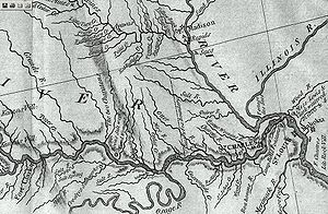

Nauvoo, Illinois
Nauvoo is a small city in Hancock County, Illinois, United States. Although the population was just 1,063 at the 2000 census, and despite being difficult to reach due to its location in a remote corner of Illinois, Nauvoo attracts large numbers of visitors for its historic importance and its...
and Keokuk, Iowa
Keokuk, Iowa
Keokuk is a city in the southeastern part of the U.S. state of Iowa and one of the county seats of Lee County. The other county seat is Fort Madison. The population was 11,427 at the 2000 census. The city is named after the Sauk Chief Keokuk, who is thought to be buried in Rand Park...
-Hamilton, Illinois
Hamilton, Illinois
Hamilton is a city in Hancock County, Illinois, United States. The population was 3,029 at the 2000 census. The city is located directly across the Mississippi River from Keokuk, Iowa. Hamilton is the largest city in Hancock County.-About Hamilton:...
is one of two major rapid
Rapid
A rapid is a section of a river where the river bed has a relatively steep gradient causing an increase in water velocity and turbulence. A rapid is a hydrological feature between a run and a cascade. A rapid is characterised by the river becoming shallower and having some rocks exposed above the...
s on the Mississippi River
Mississippi River
The Mississippi River is the largest river system in North America. Flowing entirely in the United States, this river rises in western Minnesota and meanders slowly southwards for to the Mississippi River Delta at the Gulf of Mexico. With its many tributaries, the Mississippi's watershed drains...
that limited Steamboat
Steamboat
A steamboat or steamship, sometimes called a steamer, is a ship in which the primary method of propulsion is steam power, typically driving propellers or paddlewheels...
traffic on the river through the early 19th century.
The rapids just above the confluence of the Des Moines River
Des Moines River
The Des Moines River is a tributary river of the Mississippi River, approximately long to its farther headwaters, in the upper Midwestern United States...
were to contribute to the Honey War in the 1830s between Missouri
Missouri
Missouri is a US state located in the Midwestern United States, bordered by Iowa, Illinois, Kentucky, Tennessee, Arkansas, Oklahoma, Kansas and Nebraska. With a 2010 population of 5,988,927, Missouri is the 18th most populous state in the nation and the fifth most populous in the Midwest. It...
and Iowa
Iowa
Iowa is a state located in the Midwestern United States, an area often referred to as the "American Heartland". It derives its name from the Ioway people, one of the many American Indian tribes that occupied the state at the time of European exploration. Iowa was a part of the French colony of New...
over the Sullivan Line
Sullivan Line
The Sullivan Line is the border between Missouri and Iowa.The line was initially created to establish the limits of Native American territory ; disputes over the boundary were to erupt into the Honey War; and the boundary was to be the basis for the Iowa portion of the Mormon Trail.In 1804, in the...
that separates the two states.
Various attempts to make the river navigable started in 1837 when a channel was blasted through the rapids by U.S. Army Corps of Engineers team led by Robert E. Lee
Robert E. Lee
Robert Edward Lee was a career military officer who is best known for having commanded the Confederate Army of Northern Virginia in the American Civil War....
. A canal around the rapids was built in 1877. It is now obliterated by Lock and Dam No. 19
Lock and Dam No. 19
Lock and Dam No. 19 is a lock and dam located on the Upper Mississippi River near Keokuk, Iowa. In 2004, the facility was listed in the National Register of Historic Places as Lock and Dam No. 19 Historic District, #04000179 covering , 7 buildings, 12 structures, 1 object. The lock is owned and...
.
The other major rapids barring traffic on the Mississippi is the Rock Island Rapids.
The Mississippi in its natural state widens from 2500 feet (762 m) to 4500 feet (1,371.6 m) in width at Nauvoo as it drops 22 feet (6.7 m) over 11 miles (17.7 km) over shallow limestone
Limestone
Limestone is a sedimentary rock composed largely of the minerals calcite and aragonite, which are different crystal forms of calcium carbonate . Many limestones are composed from skeletal fragments of marine organisms such as coral or foraminifera....
rocks to the confluence with Des Moines.
According to records its mean depth through the rapids was 2.4 foot (0.73152 m) and "much less" in many places.
Beginning in 1804 United States government-sponsored trading post
Trading post
A trading post was a place or establishment in historic Northern America where the trading of goods took place. The preferred travel route to a trading post or between trading posts, was known as a trade route....
s for Native Americans
Native Americans in the United States
Native Americans in the United States are the indigenous peoples in North America within the boundaries of the present-day continental United States, parts of Alaska, and the island state of Hawaii. They are composed of numerous, distinct tribes, states, and ethnic groups, many of which survive as...
as part of the Native American factory system began being built at the rapids. Forts were associated with the trading posts including Fort Johnson
Fort Johnson
This article is about the War of 1812 fortification:*For the community in New York, see Fort Johnson, New York*For the Revolutionary War British garrison named Fort Johnson see Wilmington, North Carolina...
, Fort Madison
Fort Madison, Iowa
Fort Madison, situated on the Mississippi River, is a city in and one of the county seats of Lee County, Iowa, United States. The other county seat is Keokuk. The population was 10,715 at the 2000 census...
. The forts were burned during the War of 1812
War of 1812
The War of 1812 was a military conflict fought between the forces of the United States of America and those of the British Empire. The Americans declared war in 1812 for several reasons, including trade restrictions because of Britain's ongoing war with France, impressment of American merchant...
. After the war Fort Edward was established and commanded by Jefferson Davis
Jefferson Davis
Jefferson Finis Davis , also known as Jeff Davis, was an American statesman and leader of the Confederacy during the American Civil War, serving as President for its entire history. He was born in Kentucky to Samuel and Jane Davis...
.
In 1816 U.S. Government surveyor John C. Sullivan surveyed a line stretching 100 miles (160.9 km) north from the confluence of the Kansas River
Kansas River
The Kansas River is a river in northeastern Kansas in the United States. It is the southwestern-most part of the Missouri River drainage, which is in turn the northwestern-most portion of the extensive Mississippi River drainage. Its name come from the Kanza people who once inhabited the area...
with the Missouri River
Missouri River
The Missouri River flows through the central United States, and is a tributary of the Mississippi River. It is the longest river in North America and drains the third largest area, though only the thirteenth largest by discharge. The Missouri's watershed encompasses most of the American Great...
in Kansas City, Missouri
Kansas City, Missouri
Kansas City, Missouri is the largest city in the U.S. state of Missouri and is the anchor city of the Kansas City Metropolitan Area, the second largest metropolitan area in Missouri. It encompasses in parts of Jackson, Clay, Cass, and Platte counties...
and then back east to the Des Moines River
Des Moines River
The Des Moines River is a tributary river of the Mississippi River, approximately long to its farther headwaters, in the upper Midwestern United States...
. The distance matched the rapids but when Missouri entered the Union in 1820 its constitution instead referred to the Sullivan line as "the parallel of latitude which passes through the rapids of the River Des Moines."
Missouri did not attempt to clarify the mistake even when the Iowa (tribe), Sauk and Fox (tribe) ceded all land "in Missouri" along the line from the Mississippi to the Indian Territory Line (Sullivan's line going north from the Kansas) in 1824. This created the Half-Breed Tract
Half-Breed Tract
A Half-Breed Tract was a segment of land designated in the western states by the United States government in the 19th century specifically for people of American Indian and European or European-American ancestry, known as mixed bloods. The government set aside such tracts in several U.S...
.
When interest in the rapids increased in the late 1830s as work began on making the rapids navigable, along with Iowa's beginning the process of entering as a state, Missouri took an interest in asserting control of the west side of the rapids. However, thwarted by its constitution which clearly stated the Des Moines River was the border, it instead asserted that there were no rapids where the Sullivan line crossed the Des Moines and conducted a new survey which said the rapids of the Des Moines were about 9.5 miles (15.3 km) north, near Keosauqua, Iowa
Keosauqua, Iowa
Keosauqua is a city in Van Buren County, Iowa, United States. The population was 1,066 at the 2000 census. It is the county seat of Van Buren County.-History:...
, and attempted to collect taxes in the area. This prompted the bloodless Honey War, with Iowa resisting the effort.
The Supreme Court was to ultimately decide that Iowa's southern boundary was the foot of the rapids at modern day Keokuk (although accepting the Sullivan Line for the rest of the border from about 20 miles (32.2 km) west).