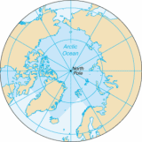
All Topics  
Arctic Ocean


   Email Print
   Bookmark   Link


Arctic Ocean


The Arctic Ocean, located in the Northern Hemisphere
Northern Hemisphere

The Northern Hemisphere is the half of a planet that is north of the equator?the word sphere literally means 'half sphere'. It is also that half of the celestial sphere north of the celestial equator....
 and mostly in the Arctic
Arctic

The Arctic is the region around the Earth's North Pole, opposite the Antarctica region around the South Pole. The Arctic includes the Arctic Ocean and parts of Canada, Greenland , Russia, the United States , Iceland, Norway, Sweden and Finland....
 north polar
North Pole

The North Pole, also known as the Geographic North Pole or Terrestrial North Pole is, subject to the caveats explained below, defined as the point in the northern hemisphere where the Earth's axis of rotation meets the Earth's surface....
 region, is the smallest and shallowest of the world's five major ocean
Ocean

An ocean is a major body of Seawater, and a principal component of the hydrosphere. Approximately 71% of the Earth's surface is covered by ocean, a World Ocean that is customarily divided into several principal oceans and smaller seas....
ic divisions. The International Hydrographic Organization
International Hydrographic Organization

The International Hydrographic Organization was originally established in 1921 as the International Hydrographic Bureau . The present name was adopted in 1970 as a result of a revised international agreement among member nations....
 (IHO) recognizes it as an ocean, although some oceanographers
Oceanography

Oceanography , also called oceanology or marine science, is the branch of Earth science that studies the ocean. It covers a wide range of topics, including marine organisms and ecosystem dynamics; ocean currents, waves, and geophysical fluid dynamics; plate tectonics and the geology of the sea floor; and fluxes of various chemi...
 call it the Arctic Mediterranean Sea or simply the Arctic Sea, classifying it as one of the mediterranean seas
Mediterranean sea (oceanography)

In oceanography, a mediterranean sea is a mostly enclosed sea that has limited exchange of deep water with outer oceans and where the water circulation is dominated by salinity and temperature differences rather than winds....
 of the Atlantic Ocean
Atlantic Ocean

The Atlantic Ocean is the second-largest of the world's oceanic divisions; with a total area of about 106.4 million square kilometres . It covers approximately one-fifth of the Earth's surface....
. Alternatively, the Arctic Ocean can be seen as the northernmost lobe of the all-encompassing World Ocean
World Ocean

The World Ocean, world ocean, or global ocean is the interconnected system of the Earth's oceanic waters, and comprises the bulk of the hydrosphere....
.

Almost completely surrounded by Eurasia
Eurasia

Eurasia is a large landmass covering about 53,990,000 km? or about 10.6% of the Earth's surface . Often considered a single continent, Eurasia comprises the traditional continents of Europe and Asia, concepts which date back to classical antiquity and the borders for which are somewhat arbitrary....
 and North America
North America

North America is the northern continent of the Americas, situated in the Earth's northern hemisphere and almost totally in the western hemisphere....
, the Arctic Ocean is largely covered by sea ice
Sea ice

Sea ice is formed from ocean water that freezes. Because the oceans consist of saltwater, this occurs at about -1.8 ?Celsius .Sea ice may be contrasted with icebergs, which are chunks of ice shelf or glaciers that calve into the ocean....
 throughout the year.


Discussion
Ask a question about 'Arctic Ocean'
Start a new discussion about 'Arctic Ocean'
Answer questions from other users
Full Discussion Forum


Encyclopedia


The Arctic Ocean, located in the Northern Hemisphere
Northern Hemisphere

The Northern Hemisphere is the half of a planet that is north of the equator?the word sphere literally means 'half sphere'. It is also that half of the celestial sphere north of the celestial equator....
 and mostly in the Arctic
Arctic

The Arctic is the region around the Earth's North Pole, opposite the Antarctica region around the South Pole. The Arctic includes the Arctic Ocean and parts of Canada, Greenland , Russia, the United States , Iceland, Norway, Sweden and Finland....
 north polar
North Pole

The North Pole, also known as the Geographic North Pole or Terrestrial North Pole is, subject to the caveats explained below, defined as the point in the northern hemisphere where the Earth's axis of rotation meets the Earth's surface....
 region, is the smallest and shallowest of the world's five major ocean
Ocean

An ocean is a major body of Seawater, and a principal component of the hydrosphere. Approximately 71% of the Earth's surface is covered by ocean, a World Ocean that is customarily divided into several principal oceans and smaller seas....
ic divisions. The International Hydrographic Organization
International Hydrographic Organization

The International Hydrographic Organization was originally established in 1921 as the International Hydrographic Bureau . The present name was adopted in 1970 as a result of a revised international agreement among member nations....
 (IHO) recognizes it as an ocean, although some oceanographers
Oceanography

Oceanography , also called oceanology or marine science, is the branch of Earth science that studies the ocean. It covers a wide range of topics, including marine organisms and ecosystem dynamics; ocean currents, waves, and geophysical fluid dynamics; plate tectonics and the geology of the sea floor; and fluxes of various chemi...
 call it the Arctic Mediterranean Sea or simply the Arctic Sea, classifying it as one of the mediterranean seas
Mediterranean sea (oceanography)

In oceanography, a mediterranean sea is a mostly enclosed sea that has limited exchange of deep water with outer oceans and where the water circulation is dominated by salinity and temperature differences rather than winds....
 of the Atlantic Ocean
Atlantic Ocean

The Atlantic Ocean is the second-largest of the world's oceanic divisions; with a total area of about 106.4 million square kilometres . It covers approximately one-fifth of the Earth's surface....
. Alternatively, the Arctic Ocean can be seen as the northernmost lobe of the all-encompassing World Ocean
World Ocean

The World Ocean, world ocean, or global ocean is the interconnected system of the Earth's oceanic waters, and comprises the bulk of the hydrosphere....
.

Almost completely surrounded by Eurasia
Eurasia

Eurasia is a large landmass covering about 53,990,000 km? or about 10.6% of the Earth's surface . Often considered a single continent, Eurasia comprises the traditional continents of Europe and Asia, concepts which date back to classical antiquity and the borders for which are somewhat arbitrary....
 and North America
North America

North America is the northern continent of the Americas, situated in the Earth's northern hemisphere and almost totally in the western hemisphere....
, the Arctic Ocean is largely covered by sea ice
Sea ice

Sea ice is formed from ocean water that freezes. Because the oceans consist of saltwater, this occurs at about -1.8 ?Celsius .Sea ice may be contrasted with icebergs, which are chunks of ice shelf or glaciers that calve into the ocean....
 throughout the year. The Arctic Ocean's temperature
Temperature

In physics, temperature is a physical property of a Physical system that underlies the common notions of hot and cold; something that feels hotter generally has the greater temperature....
 and salinity
Salinity

Salinity is the saltiness or dissolved salt content of a body of water. Salinity in Australian English and North American English may also refer to the salt in soil ....
 vary season
Season

A season is one of the major divisions of the year, generally based on yearly periodic changes in weather.Seasons result from the yearly revolution of the Earth around the Sun and the Axial tilt....
ally as the ice
Ice

Ice is a solid phases of matter, usually crystalline solid, of a non-metallic substance that is liquid or gas at room temperature, such as ammonia ice or methane ice....
 cover melts and freezes; its salinity is the lowest on average of the five major oceans, due to low evaporation
Evaporation

Evaporation is the slow vaporization of a liquid and the reverse of condensation. A type of phase transition, it is the process by which molecules in a liquid State of matter spontaneously become gaseous ....
, heavy freshwater
Freshwater

Freshwater is a word that refers to bodies of water such as ponds, lakes, rivers and streams containing low concentrations of dissolved salts and other total dissolved solids....
 inflow from river
River

A river is a natural stream of water, usually freshwater, flowing toward an ocean, a lake, or another stream. In some cases a river flows into the ground or dries up completely before reaching another body of water....
s and stream
Stream

A stream is a body of water less than 60 feet wide with a current , confined within a stream bed and stream banks. Depending on its locale or certain characteristics, a stream may be referred to as brook, beck, Burn , creek, crick, kill, lick , rill, river syke, bayou, rivu...
s, and limited connection and outflow to surrounding oceanic waters with higher salinities. The summer shrinking of the ice has been quoted at 50%. The National Snow and Ice Data Center
National Snow and Ice Data Center

The National Snow and Ice Data Center, or NSIDC, is a United States information and referral center in support of geographical pole and cryosphere research....
 (NSIDC) use satellite data to provide a daily record of Arctic sea ice cover and the rate of melting compared to an average period and specific past years.

Arctic Ocean

Geography

The Arctic Ocean occupies a roughly circular basin and covers an area of about , almost the size of Russia
Russia

Russia , or the Russian Federation , is a list of countries spanning more than one continent country extending over much of northern Eurasia....
. The coastline length is . It is surrounded by the land masses of Eurasia, North America, Greenland
Greenland

Greenland is a member country of the Kingdom of Denmark located between the Arctic Ocean and Atlantic Oceans, east of the Canadian Arctic Archipelago....
, and several island
Island

An island or isle is any piece of land that is surrounded by water. Very small islands such as emergent land features on atolls are called islets....
s. It includes Baffin Bay
Baffin Bay

Baffin Bay is a sea between the Atlantic Ocean and Arctic Ocean oceans. It is 1,130 km across from north to south. It is not navigable most of the year because of the presence of large numbers of icebergs....
, Barents Sea
Barents Sea

The Barents Sea is a part of the Arctic Ocean located north of Norway and Russia. It is a rather deep Continental shelf sea , bordered by the shelf edge towards the Norwegian Sea in the west, the island of Svalbard in the northwest, and the islands of Franz Josef Land and Novaya Zemlya in the northeast and east....
, Beaufort Sea
Beaufort Sea

The Beaufort Sea is the portion of the Arctic Ocean located north of the Northwest Territories, the Yukon, and Alaska and west of Canadian Arctic islands....
, Chukchi Sea
Chukchi Sea

Chukchi Sea is a marginal sea of the Arctic Ocean. It is bounded on the west by the De Long Strait, off Wrangel Island, and in the east by Point Barrow, Alaska, beyond which lies the Beaufort Sea....
, East Siberian Sea
East Siberian Sea

The East Siberian Sea is a marginal sea in the Arctic Ocean. It is located between the Arctic Cape in the North, the coast of Siberia in the South, the New Siberian Islands in the West and Cape Billings, close to Gytkhelen, Chukotka, and Wrangel Island in the East....
, Greenland Sea
Greenland Sea

The Greenland Sea is the northernmost part of the North Atlantic Ocean immediately south of the Arctic Ocean. It encompasses some 1,205,000 square km ....
, Hudson Bay
Hudson Bay

Hudson Bay is a large , relatively shallow body of water in northeastern Canada. It is approximately 850 miles long and 650 miles wide. It drains a very large area that includes parts of Ontario, Quebec, Saskatchewan, Alberta, most of Manitoba, parts of North Dakota, South Dakota, Minnesota, and Montana, and the southeastern area of Nunavut...
, Hudson Strait
Hudson Strait

Hudson Strait links the Atlantic Ocean to Hudson Bay in Canada. It lies between Baffin Island and the northern coast of Quebec, its eastern entrance marked by Cape Chidley and Resolution Island ....
, Kara Sea
Kara Sea

The Kara Sea is part of the Arctic Ocean north of Siberia. It is separated from the Barents Sea to the west by the Kara Strait and Novaya Zemlya, and the Laptev Sea to the east by the Severnaya Zemlya....
, Laptev Sea
Laptev Sea

The Laptev Sea is a marginal sea of the Arctic Ocean. It is located between the eastern coast of Siberia, Taimyr Peninsula, the Severnaya Zemlya and the New Siberian Islands....
, White Sea
White Sea

The White Sea is an inlet of the Barents Sea on the northwest coast of Russia. It is surrounded by Karelia to the west, the Kola peninsula to the north, and the Kanin Peninsula to the northeast....
 and other tributary bodies of water. It is connected to the Pacific Ocean
Pacific Ocean

The Pacific Ocean is the largest of the Earth's oceanic divisions. Its name is derived from the Latin name Mare Pacificum, "peaceful sea", bestowed upon it by the Portugal explorer Ferdinand Magellan....
 by the Bering Strait
Bering Strait

The Bering Strait is a sea strait between Cape Dezhnev, Chukotka Autonomous Okrug, the easternmost point of the Asian continent and Cape Prince of Wales, Alaska, the westernmost point of the North American continent, with latitude of about 65? 40' north, slightly south of the polar circle....
 and to the Atlantic Ocean through the Greenland Sea
Greenland Sea

The Greenland Sea is the northernmost part of the North Atlantic Ocean immediately south of the Arctic Ocean. It encompasses some 1,205,000 square km ....
 and Labrador Sea
Labrador Sea

Labrador Sea is an arm of the North Atlantic Ocean between Labrador and Greenland.Water depths in the center of Labrador Sea are around and it is flanked by continental shelf to the southwest, northwest, and northeast....
.

According to the International Hydrographic Organization
International Hydrographic Organization

The International Hydrographic Organization was originally established in 1921 as the International Hydrographic Bureau . The present name was adopted in 1970 as a result of a revised international agreement among member nations....
, the limits of the Arctic Ocean proper are (see ):
  • A great circle
    Great circle

    A great circle of a sphere is a circle that runs along the surface of that sphere so as to cut it into two equal halves. The great circle therefore has both the same circumference and the same center as the sphere....
     line running from Cape Morris Jesup
    Cape Morris Jesup

    Cape Morris Jesup is the northernmost point of mainland Greenland at and is 711.8 km from the North_Pole#Geographic_North_Pole. Robert Peary reached the cape in 1892, believing it to be the extreme points of the world, although it was later found to lie slightly to the south of the northernmost tip of Kaffeklubben Island....
    , the northernmost point of Greenland to the northernmost point of Spitsbergen
    Spitsbergen

    Spitsbergen is a Norway island, the largest island of the Svalbard archipelago in the Arctic Ocean. The island of Spitsbergen covers approximately 39,044 km? ....
     (south of which line lies the Greenland Sea).
  • Parallel 80° North to North East Land (Nordaustlandet
    Nordaustlandet

    Nordaustlandet is the second largest island in the Norway archipelago of Svalbard, with an area of 14,443 km?. As its name suggests, it lies north east of Spitsbergen, separated by the Hinlopen Strait....
    ).
  • The north shore of Nordaustlandet to its easternmost point, Cape Leigh Smith .
  • A line running from Cape Leigh Smith to Cape Kohlsaat
    Cape Kohlsaat

    Cape Kohlsaat is a point on the eastern shore of Graham Bell Island, the easternmost island of Franz Josef Land, Russia. It is also the easternmost limit of the Franz Josef Archipelago....
    , the easternmost point of Franz Josef Land
    Franz Josef Land

    Franz Josef Land, Franz Joseph Land, or Francis Joseph's Land is an archipelago located in the far north of Russia. It is found in the Arctic Ocean north of Novaya Zemlya and east of Svalbard, and is administered by Arkhangelsk Oblast....
     (south of which line lies the Barents Sea].
  • A line running from Cape Kohlsaat to Cape Molotov (Arctic Cape
    Arctic Cape

    The Arctic Cape is the northernmost point of the Komsomolets Island, which in turn is the northernmost island of the Russian Severnaya Zemlya archipelago in the Arctic Ocean....
    ), the northernmost point of Komsomolets Island
    Komsomolets Island

    Komsomolets Island is the northernmost island of the Severnaya Zemlya group in the Russian Arctic, and the third largest island in the group. It is the List of islands by area on earth....
     (south of which line lies the Kara Sea).
  • A line running from Arctic Cape to the northernmost point of Kotelny Island
    Kotelny/Faddeyevsky Island

    Kotelny Island and Faddeyevsky Island are part of the Anzhu Islands subgroup of the New Siberian Islands located between the Laptev Sea and the East Siberian Sea in the Russian Arctic....
     (south of which line lies the Laptev Sea).
  • A line running from the northernmost point of Kotelny Island to the northernmost point of Wrangel Island
    Wrangel Island

    Wrangel Island is an island in the Arctic Ocean, between the Chukchi Sea and East Siberian Sea. Wrangel Island lies astride the 180th meridian meridian ....
     (south of which line lies the East Siberian Sea).
  • A line running from the northernmost point of Wrangel Island to Point Barrow
    Point Barrow

    Point Barrow or Nuvuk is a Headlands and bays on the Arctic Ocean in the U.S. state of Alaska, northeast of Barrow, Alaska. It is the Extreme points of the United States of the United States, at ....
    , the northernmost point of Alaska
    Alaska

    Alaska is the largest U.S. state of the United States by area; it is situated in the northwest extremity of the North American continent, with Canada to the east, the Arctic Ocean to the north, and the Pacific Ocean to the west and south, with Russia further west across the Bering Strait....
     (south of which line lies the Chuckchi Sea).
  • A line running from Point Barrow to Cape Land's End on Prince Patrick Island
    Prince Patrick Island

    A member of the Canadian Arctic Archipelago, Prince Patrick Island is the westernmost of the Queen Elizabeth Islands in the Northwest Territories of Canada....
    , Northwest Territories
    Northwest Territories

    The Northwest Territories are a provinces and territories of Canada of Canada.Located in northern Canada, it borders Canada's two other territories, Yukon to the west and Nunavut to the east, and three provinces: British Columbia to the southwest, Alberta and Saskatchewan to the south....
     (south of which line lies the Beaufort Sea).
  • The northwest
    Cardinal direction

    The four cardinal directions or cardinal points are north, south, east, and west, commonly denoted by their initials - N, S, E, W. They are mostly used for geography orientation on Earth but may be calculated anywhere on a rotating astronomical object....
     coast of Prince Patrick Island north to Cape Leopold M'Clintock, its northernmost point .
  • A line running from Cape Leopold M'Clintock to Cape Murray on Brock Island
    Brock Island

    Brock Island is one of the Canadian arctic islands located in the Northwest Territories, Canada. Located at 77?52'N 114?19'W, it measures 764 km? in size....
     .
  • The northwest coast
    Coast

    The coast is defined as that part of the land adjoining or near the ocean or its saltwater arms. A precise line that can be called a coastline cannot be determined due to the process of tides....
     of Brock Island north to its northernmost point .
  • A line running from the northernmost point of Brock Island to Cape Mackay on Borden Island
    Borden Island

    Borden Island is an uninhabited, low-lying island in the Queen Elizabeth Islands of northern Canada. With an area of 2 795 km? in size, it is the List of islands by area, and List of Canadian islands by area....
    , its westernmost point .
  • The northwest coast of Borden Island north to Cape Malloch (the northernmost point of the Northwest Territories).
  • A line running from Cape Malloch to Cape Isachsen on Ellef Ringnes Island
    Ellef Ringnes Island

    Ellef Ringnes Island is one of the Sverdrup Islands in Nunavut, Canada. A member of the Canadian Arctic Archipelago, it lies east of Borden Island, west of Amund Ringnes Island and has an area of 4,361 square miles , making it the list of islands by area and List of Canadian islands by area....
    , Nunavut
    Nunavut

    Nunavut is the largest and newest Provinces and territories of Canada of Canada; it was separated officially from the Northwest Territories on April 1, 1999 via the Nunavut Act and the Nunavut Land Claims Agreement Act, though the actual boundaries had been established in 1993....
    , its northwestern most point .
  • A line running from Cape Isachsen to the northwestern most point of Meighen Island
    Meighen Island

    Meighen Island is an uninhabited Canadian arctic islands in Nunavut, Canada. Located at 79?55'N 99?30'W, it measures 955 km? in size and is topped with an icecap....
     .
  • A line running from the northwestern most point of Meighen Island to Cape Stallworthy on Axel Heiberg Island
    Axel Heiberg Island

    Axel Heiberg Island is the list of islands by area and List of Canadian islands by area. According to Statistics Canada , it has an area of 43 178 km? ....
    , its northernmost point .
  • A line running from Cape Stallworthy to Cape Colgate on Ellesmere Island
    Ellesmere Island

    Ellesmere Island is part of the Qikiqtaaluk Region of the Canada territory of Nunavut. Lying within the Canadian Arctic Archipelago it is considered part of the Queen Elizabeth Islands, with Cape Columbia being the most northerly point of land in Canada....
    , its westernmost point .
  • The north coast of Ellesmere Island north to Cape Columbia
    Cape Columbia

    Cape Columbia is the northernmost point of land of Canada, located on Ellesmere Island in the Qikiqtaaluk Region of Nunavut. It marks the westernmost coastal point of Lincoln Sea in the Arctic Ocean....
    , its northernmost point .
  • A line running from Cape Columbia to Cape Morris Jesup (south of which line lies the Lincoln Sea
    Lincoln Sea

    Lincoln Sea is a body of water in the Arctic Ocean, stretching from Cape Columbia, Canada in the west to Cape Morris Jesup, Greenland in the east....
    ).


Arctic
An underwater ridge
Mid-ocean ridge

A mid-ocean ridge or mid-oceanic ridge is an underwater mountain range, typically having a valley known as a rift running along its spine, formed by plate tectonics....
, the Lomonosov Ridge
Lomonosov Ridge

The Lomonosov Ridge is an unusual underwater ridge of continental crust in the Arctic Ocean. It spans 1800 Kilometre from the New Siberian Islands over the central part of the ocean to Ellesmere Island of the Canadian Arctic islands....
, divides the deep sea North Polar Basin
North Polar Basin

The North Polar Basin is an oceanic basin in the Arctic Ocean, consisting of two main parts, the Amerasian Basin and the Eurasian Basin , which are separated by the Lomonosov Ridge, a mid-ocean ridge running between north Greenland and the Svalbard archipelago....
 into two oceanic basin
Oceanic basin

Hydrologically, an oceanic basin may be anywhere on Earth that is covered by seawater, but geologically ocean basins are large Basin that are below sea level....
s: the Eurasian Basin
Eurasian Basin

The Eurasian Basin, is one of the two major basins into which the North Polar Basin of the Arctic Ocean is split by the Lomonosov Ridge . It is an extension of the North Atlantic Basin....
, which is between deep, and the Amerasian Basin
Amerasian Basin

The Amerasian Basin is one of the two major basins into which the North Polar Basin of the Arctic Ocean is split by the Lomonosov Ridge . It extends from Ellesmere Island to the East Siberian Sea....
 (sometimes called the North American, or Hyperborean Basin), which is about deep. The bathymetry
Bathymetry

Bathymetry is the study of underwater depth, of the third dimension of lake or ocean floors. In other words, bathymetry is the underwater equivalent to hypsometry....
 of the ocean bottom is marked by fault-block
Fault-block

Fault-block landforms are created when large areas of bedrock are widely broken up by fault creating large vertical displacements. This occurrence is fairly common....
 ridges, plains of the abyssal zone
Abyssal plain

Abyssal plains are flat or very gently sloping areas of the deep ocean basin floor. They are among the Earth's flattest and smoothest regions and the least explored....
, ocean deeps, and basins. The average depth of the Arctic Ocean is . The deepest point is in the Eurasian Basin, at .

The two major basins are further subdivided by ridges into the Canada Basin (between Alaska/Canada
Canada

Canada is a country occupying most of northern North America, extending from the Atlantic Ocean in the east to the Pacific Ocean in the west and northward into the Arctic Ocean....
 and the Alpha Ridge
Alpha Ridge

The Alpha Ridge is a major volcanic ridge under the Arctic Ocean between the Canada Basin and the Lomonosov Ridge. It was active during the formation of the Amerasian Basin....
), Makarov Basin (between the Alpha and Lomonosov Ridges), Fram Basin (between Lomonosov and Gakkel
Gakkel Ridge

The Gakkel Ridge is a mid-oceanic ridge, a divergent tectonics plate boundary between the North American Plate and the Eurasian Plate. It is located in the Arctic Ocean between Greenland and Siberia with a length of about 1,800 kilometers....
 ridges), and Nansen Basin (Amundsen Basin) (between the Gakkel Ridge and the continental shelf
Continental shelf

The continental shelf is the extended perimeter of each continent and associated coastal plain, and was part of the continent during the glacial periods, but is undersea during Ice age such as the current epoch by relatively shallow seas and Bay....
 that includes the Franz Josef Land
Franz Josef Land

Franz Josef Land, Franz Joseph Land, or Francis Joseph's Land is an archipelago located in the far north of Russia. It is found in the Arctic Ocean north of Novaya Zemlya and east of Svalbard, and is administered by Arkhangelsk Oblast....
).

The Arctic Ocean contains a major choke point
Choke point

In military strategy, a choke point is a geographical feature on land such as a valley or defile , or at sea such as a strait which an armed force is forced to pass, sometimes on a substantially narrower front, and therefore greatly decreasing its combat power, in order to reach its objective ....
 in the southern Chukchi Sea, which provides northern access to the Pacific Ocean via the Bering Strait between North America and the Russian city of Arkhangelsk
Arkhangelsk

Arkhangelsk , formerly called Archangel in English language, is a types of inhabited localities in Russia and the administrative center of Arkhangelsk Oblast, Russia....
. The Arctic Ocean also provides the shortest marine link between the extremes of eastern and western Russia. There are several floating research station
Research station

A research station is a station built for the purpose of conducting scientific research on a given site, or aspects of the site. These sites might include outer space and oceans....
s in the Arctic, operated by the US and Russia.

The greatest inflow
Inflow (hydrology)

In hydrology, the inflow of a body of water is the source of the water in the body of water. It can also refer to the average volume of incoming water in unit time....
 of water comes from the Atlantic by way of the Norwegian Current
Norwegian Current

The Norwegian Current is a water current that flows north-easterly along the Atlantic coast of Norway at depths of between 50 and 100 meters. It contrasts with the North Atlantic Current because it is colder and has salinity in it, having most of its tributary water coming from the Brackish water Baltic Sea as well as the List of Norwegian F...
, which then flows along the Eurasian coast. Water also enters from the Pacific via the Bering Strait. The East Greenland Current
East Greenland Current

The East Greenland Current originates in the Arctic Ocean and brings cold, low salinity, southbound water along the eastern coast of Greenland....
 carries the major outflow
Discharge (hydrology)

In hydrology, the discharge or outflow of a river is the volume of water transported by it in a certain amount of time. It is contrasted with inflow ....
.

Ice covers most of the ocean surface year-round, causing subfreezing temperatures much of the time. The Arctic is a major source of very cold air
Cold front

A cold front is defined as the leading edge of a cooler and drier mass of air, replacing a warmer mass of air.Development of cold front...
 that inevitably moves toward the equator
Equator

The equator is the intersection of the Earth's surface with the Plane perpendicular to the Earth's rotation and containing the Earth's center of mass....
, meeting with warmer air
Warm front

A warm front is defined as the leading edge of an advancing Air mass of warm air; it separates warm air from the colder air ahead....
 in the middle latitude
Latitude

Latitude, usually denoted symbolically by the Greek letter phi gives the location of a place on Earth north or south of the equator. Lines of Latitude are the horizontal lines shown running east-to-west on maps ....
s and causing rain
Rain

Rain is liquid precipitation . On Earth, it is the condensation of atmospheric water vapor into droplet heavy enough to fall, often making it to the surface....
 and snow
Snow

Snow is a type of precipitation in the form of crystalline water ice, consisting of a multitude of snowflakes that fall from clouds. The process of this precipitation is called snowfall....
. Marine life
Marine biology

Marine biology is the scientific study of living organisms in the ocean or other Marine or brackish bodies of water.Given that in biology many scientific classification, families and Genera have some species that live in the sea and others that live on land, marine biology classifies species based on the environment rather than on taxon...
 abounds in open areas, especially the more southerly waters. The ocean's major port
Port

||-||-|-||-||-||-||-||-||-|}A port is a facility for receiving ships and transferring cargo. They are usually found at the edge of an ocean, sea, river, or lake....
s are the cities
City

A city is an urban area with a high population density and a particular administrative, legal, or historical status.Large industrialized cities generally have advanced systems for sanitation, utilities, land usage, house, and transportation and more....
 of Murmansk
Murmansk

Murmansk is a types of inhabited localities in Russia and seaport in the extreme northwest part of Russia, on the Kola Bay, 12 km from the Barents Sea on the northern shore of the Kola Peninsula, not far from Russia's borders with Norway and Finland....
, Arkhangelsk, Churchill
Churchill, Manitoba

Churchill is a town on the shore of Hudson Bay in Manitoba, Canada, situated at the estuary of the Churchill River at Hudson Bay. The small community stands at an ecotone, on the Hudson Plains, at the juncture of three ecoregions: the boreal forest to the south, the Arctic tundra to the northwest, and the Hudson Bay to the north....
 and Prudhoe Bay
Prudhoe Bay, Alaska

Prudhoe Bay is a census-designated place located in North Slope Borough, Alaska in the U.S. state of Alaska. As of the 2000 census , the population of the CDP was 5....
.

The Arctic Ocean is encompassed by the Arctic shelves, one of which, the Siberian Shelf
Siberian Shelf

The Siberian Shelf, one of the Arctic shelves, is the largest continental shelf of the Earth, a part of the continental shelf of Russia. It extends from the continent of Eurasia in the general area of North Siberia into the Arctic Ocean....
, is the largest on Earth
Earth

Earth is the third planet from the Sun. Earth is the largest of the terrestrial planets in the Solar System in diameter, mass and density. It is also referred to as the World and Wiktionary:Terra.Note that by International Astronomical Union convention, the term "Terra" is used for naming extensive land masses, rather...
.

History


For much of European history
History of Europe

The history of Europe describes the passage of time from humans inhabiting the European Continental Europe to the present day. For convenience sake, historians divide long periods into more manageable eras....
, the geography
Geography

Geography is the study of the Earth and its lands, features, inhabitants, and phenomena. A literal translation would be "to describe or write about the Earth"....
 of the North Polar regions remained largely unexplored and conjectural. Pytheas
Pytheas

Pytheas of Massilia , 4th century BC, was a Greece geography and exploration from the Greek colonies colony, Massilia . He made a voyage of exploration to northwestern Europe at about 325 BC....
 of Massalia
Marseille

"Marseille" is the second-largest city of France and forms the third-largest aire urbaine, after those of Paris and Lyon, with a population recorded to be 1,516,340 at the 1999 census and estimated to be 1,605,000 in 2007....
 recorded an account of a journey northward in 325 BCE, to a land he called "Eschate Thule," where the Sun
Sun

The Sun , a G V star, is the star at the center of the Solar System. The Earth and other matter orbit the Sun, which by itself accounts for about 98.6% of the Solar System's mass....
 only set for three hours each day and the water was replaced by a congealed substance "on which one can neither walk nor sail
Sailing

Sailing is the art of controlling a boat with large pieces of canvas cloth called sails. By changing the rigging, rudder, and dagger or centre board, a sailor manages the force of the wind on the sails in order to change the direction and speed of a boat....
." He was probably describing loose sea ice known today as "growler
Iceberg

An iceberg is a large piece of freshwater ice that has broken off from a snow-formed glacier or ice shelf and is floating in open water. It may subsequently become frozen into pack ice or come to rest on the seabed in shallower water, causing ice scour....
s" and "bergy bits." His "Thule" may have been Iceland
Iceland

Iceland, officially the Republic of Iceland , is an island country located in the North Atlantic Ocean between mainland Europe and Greenland....
, though Norway
Norway

Norway , officially the Kingdom of Norway, is a constitutional monarchy in Northern Europe that occupies the western portion of the Scandinavian Peninsula....
 is more often suggested.

Early cartographer
Cartography

File:Mediterranean chart fourteenth century2.jpgCartography is the study and practice of making Geography Map. Combining science, aesthetics, and technique, cartography builds on the premise that we can model reality in ways that communicate spatial information effectively....
s were unsure whether to draw the region around the North Pole as land (as in Johannes Ruysch
Johannes Ruysch

Johannes Ruysch , a.k.a. Johann Ruijsch or Giovanni Ruisch was an explorer, cartographer, astronomer, manuscript illustrator and painter from the Low Countries who produced a famous map of the world: the second oldest known printed representation of the New World....
's map of 1507, or Gerardus Mercator
Gerardus Mercator

Gerardus Mercator was a Flanders cartographer. He was born in Rupelmonde in the County of Flanders. He is remembered for the Mercator projection world map named after him....
's map of 1595) or water (as with Martin Waldseemüller
Martin Waldseemüller

Martin Waldseem?ller was a Germany cartography. He and Matthias Ringmann are credited with the first recorded usage of the word Americas, on the 1507 map Universalis Cosmographia in honor of the Florentine explorer Amerigo Vespucci....
's world map of 1507). The fervent desire of Europe
Europe

Europe is, conventionally, one of the world's seven continents. Comprising the westernmost peninsula of Eurasia, Europe is generally divided from Asia to its east by the water divide of the Ural Mountains, the Ural , the Caspian Sea, and by the Caucasus Mountains to the southeast....
ans for a northern passage to "Cathay
Cathay

Cathay is the Anglicized version of "Catai" and an alternative name for China in English. It originates from the word Khitan people , the name of a barbarian tribe that founded the Liao Dynasty which ruled much of Northern China from 907 to 1125, and who had a state of their own centered around today's Kyrgyzstan for another century...
" (China
China

China is a Culture of China, an ancient civilization, and, depending on perspective, a national or multinational entity extending over a large area in East Asia....
) caused water to win out, and by 1723 mapmakers such as Johann Homann
Johann Homann

Johann Baptist Homann was a Germany geographer and cartography, who made maps of the Americas .Homann was born in Oberkammlach near Kammlach, which is now in Bavaria....
 featured an extensive "Oceanus Septentrionalis" at the northern edge of their charts. The few expeditions to penetrate much beyond the Arctic Circle
Arctic Circle

The Arctic Circle is one of the five major circle of latitude that mark maps of the Earth. It is the parallel of latitude that runs 66degree 33'39? north of the Equator....
 in this era added only small islands, such as Novaya Zemlya
Novaya Zemlya

Novaya Zemlya Novaya Zemlya consists of two major islands, separated by the narrow Matochkin Strait, and a number of smaller ones. The two main islands are Severny Island and Yuzhny Island ....
 (11th century) and Spitsbergen (1596), though since these were often surrounded by pack-ice
Drift ice

Drift ice is ice that floats on the surface of the water in cold regions, as opposed to fast ice, which is attached to a shore. Usually drift ice is carried along by winds and sea currents, hence its name, "drift ice"....
 their northern limits were not so clear. The makers of navigational chart
Nautical chart

A nautical chart is a graphic representation of a Sea area and adjacent coastal regions. Depending on the scale of the chart, it may show depths of water and heights of land , natural features of the seabed, details of the coastline, navigational hazards, locations of natural and man-made aids to navigation, information on tides and Current...
s, more conservative than some of the more fanciful cartographers, tended to leave the region blank, with only the bits of known coastline sketched in.

This lack of knowledge of what lay north of the shifting barrier of ice gave rise to a number of conjectures. In England
England

native_name =|conventional_long_name = England|common_name = England|image_flag = Flag of England.svg|image_coat = England COA.svg|symbol_type = Royal Coat of Arms...
 and other European nations, the myth of an "Open Polar Sea" was long-lived and persistent. John Barrow
Sir John Barrow, 1st Baronet

Sir John Barrow, 1st Baronet, Fellow of the Royal Society , Royal Geographical Society , Doctor of Laws was an England statesman.He was born in the hamlet of Dragley Beck in the parish of Ulverston in Lancashire....
, longtime Second Secretary of the British
United Kingdom of Great Britain and Ireland

The United Kingdom of Great Britain and Ireland was the formal name and the state form of the United Kingdom from 1 January 1801 until 12 April 1927....
 Admiralty
Admiralty

The Admiralty was formerly the authority in the United Kingdom responsible for the command of the Royal Navy. Originally exercised by a single person, the office of Lord High Admiral was from the 18th century onward almost invariably put "in commission", and was exercised by a Board of Admiralty....
, made this belief the cornerstone of his campaign of Arctic exploration
Polar exploration

Polar exploration is the physical exploration of the Arctic and Antarctic regions of the Earth. It is also denotes the historical period during which mankind most intensely explored the regions north of the Arctic Circle and south of the Antarctic Circle....
 from 1818 to 1845. In the United States
United States

The United States of America is a Federal government constitutional republic comprising U.S. state and a federal district. The country is situated mostly in central North America, where its Contiguous United States and Washington, D.C., the Capital districts and territories, lie between the Pacific Ocean and Atlantic Oceans, Borders of the U...
 in the 1850s and '60s, the explorers Elisha Kane
Elisha Kane

Elisha Kent Kane was a medical officer in the United States Navy during the first half of the 19th century. He was a member of two Arctic expeditions to rescue the explorer Sir John Franklin....
 and Isaac Israel Hayes
Isaac Israel Hayes

For the African-American musician, see Isaac Hayes.Isaac Israel Hayes was an Arctic explorer and physician.Hayes was born in Chester County, Pennsylvania, Pennsylvania....
 both claimed to have seen the outskirts of this elusive body of water. Even quite late in the century, the eminent authority Matthew Fontaine Maury
Matthew Fontaine Maury

Matthew Fontaine Maury , USN was an United States astronomer, historian, oceanographer, meteorologist, cartographer, author, geologist, and educator....
 included a description of the Open Polar Sea in his textbook
Textbook

A textbook is a manual of instruction or a standard book in any branch of study. They are produced according to the demand of educational institutions....
 The Physical Geography of the Sea (1883). Nevertheless, as all the explorer
Exploration

Exploration is the act of searching or traveling a terrain for the purpose of discovery, e.g. of unknown people, including space , for Petroleum, gas, coal, ores, caves, water , or information....
s who trekked closer and closer to the pole reported, the polar ice cap
Ice cap

An ice cap is an ice mass that covers less than 50 000 km? of land area . Masses of ice covering more than 50 000 km? are termed an ice sheet....
 was ultimately quite thick, and persists year-round.

Fridtjof Nansen
Fridtjof Nansen

Fridtjof Wedel-Jarlsberg Nansen was a Norway explorer, scientist and diplomat. Nansen was awarded the Nobel Peace Prize in 1922 for his work as a League of Nations High Commissioner....
 was the first to make a nautical
Seamanship

Seamanship is the art of operating a ship or boat.It involves a knowledge of a variety of topics and development of specialised skills including: navigation and international maritime law; weather, meteorology and forecasting; watchstanding; ship-handling and small boat handling; operation of deck equipment, anchors and cables; ropework an...
 crossing of the Arctic Ocean, in 1896. The first surface crossing of the ocean was led by Wally Herbert
Wally Herbert

Sir Walter William "Wally" Herbert was an United Kingdom polar explorer, writer and artist. In 1969 he became the first man to walk undisputed to the North Pole, on the 60th anniversary of Robert Peary's famous, but disputed, expedition....
 in 1969, in a dog sled
Dog sled

A dog sled is a sled pulled by one or more sled dogs used to travel over ice and through snow. Numerous types of sleds are used, depending on their function....
 expedition from Alaska to Svalbard with air support.

Since 1937, Soviet and Russian manned drifting ice stations
Soviet and Russian manned drifting ice stations

Soviet and Russian manned drifting ice stations are important contributors to polar exploration of the Arctic. An idea to use the drift ice for the exploration of nature in the high latitudes of the Arctic Ocean belongs to Fridtjof Nansen, who fulfilled it on Fram between 1893 and 1896....
 extensively monitored the Arctic Ocean. Scientific settlements were established on the drift ice and carried thousands of kilometres by ice floes.

Climate

The images below compare the average late winter and late summer polar ice pack
Polar ice cap

A polar ice cap is a high-latitude region of a planet or natural satellite that is covered in ice. There are no requirements with respect to size or composition for a body of ice to be termed a polar ice cap, nor any geological requirement for it to be over land; only that it must be a body of solid phase matter in the polar region....
 of the Arctic Ocean, averaged between the years 1978 and 2002, which denotes variation in amounts of ice pack during these time periods.
North Pole February Ice Pack 1978 2002
North Pole September Ice Pack 1978 2002
Under the influence of the present ice age
Quaternary glaciation

Quaternary glaciation, also known as the Pleistocene glaciation, the current ice age or simply the ice age, refers to the period of the last few million years in which permanent ice sheets were established in Antarctica and perhaps Greenland, and fluctuating ice sheets have occurred elsewhere ....
, the ocean is contained in a polar climate
Polar climate

Regions with a polar climate are characterized by a lack of warm summers .The tundra covers over 20% of the earth. The sun shines 24 hours in the summer, and barely shines at all in the winter ....
 characterized by persistent cold and relatively narrow annual temperature range
Temperature range

Temperature range is the numerical difference between the minimum and maximum values of temperature observed in a system, such as atmospheric temperature in a given location....
s. Winters are characterized by continuous darkness
Darkness

Darkness is the absence of light. Scientifically it is only possible to have a reduced amount of light. The emotional response to an absence of light has inspired metaphor in literature, symbolism in art, and emphasis....
 (polar night
Polar night

The polar night is the night lasting more than 24 hours, usually inside the polar circles. The opposite phenomenon, when the sun stays above the horizon for a long time is called the polar day, or midnight sun....
), cold and stable weather conditions, and clear skies; summers are characterized by continuous daylight
Daylight

Daylight or the light of day is the combination of all direct and indirect sunlight outdoors during the Daytime . This includes direct sunlight, diffuse sky radiation, and both of these reflected from the Earth and terrestrial objects....
 (midnight sun
Midnight sun

The midnight sun is a natural phenomenon occurring in latitudes north and nearby to the south of the Arctic Circle, and south and nearby to the north of the Antarctic Circle where the sun remains visible at the local midnight....
), damp and fog
Fog

Fog is a cloud bank that is in contact with the ground. A cloud may be considered partly fog; for example, the part of a cloud that is suspended in the air above the ground is not considered fog, whereas the part of the cloud that comes in contact with higher ground is considered fog....
gy weather, and weak cyclone
Cyclone

In meteorology, a cyclone refers to an area of closed, circular fluid motion rotating in the same direction as the Earth's rotation. This is usually characterized by inward spiraling winds that rotate counter clockwise in the Northern Hemisphere and clockwise in the Southern Hemisphere of the Earth....
s with rain or snow.

The temperature of the surface of the Arctic Ocean is fairly constant, near the freezing point
Melting point

The melting point of a solid is the temperature range at which it changes states of matter from solid to liquid. At the melting point the solid and liquid phase exist in equilibrium....
 of seawater
Seawater

Seawater is water from a sea or ocean. On average, seawater in the world's oceans has a salinity of about 3.5%, or 35 parts per thousand . This means that every 1 kg of seawater has approximately 35 grams of sea salt ....
, slightly below . In the winter the relatively warm ocean water exerts a moderating influence, even when covered by ice. This is one reason why the Arctic does not experience the extremes of temperature seen on the Antarctic continent
Antarctica

Antarctica is Earth's southernmost continent, overlying the South Pole. It is situated in the Antarctica of the southern hemisphere, almost entirely south of the Antarctic Circle, and is surrounded by the Southern Ocean....
.

There is considerable seasonal variation in how much pack ice of the Arctic ice pack
Polar ice packs

Polar ice packs are large areas of pack ice formed from seawater in the Earth's polar regions, known as polar ice caps: the Arctic ice pack of the Arctic Ocean and the Antarctic ice pack of the Southern Ocean, fringing the Antarctic ice sheet....
 covers the Arctic Ocean. Much of the ocean is also covered in snow for about 10 months of the year. The maximum snow cover is in March or April — about over the frozen ocean.

Climate has varied significantly in the past; as recently as 55 million years ago, during the Paleocene–Eocene Thermal Maximum the region reached an average annual temperature of 10-20 °C (50-68 °F); the surface waters of the northernmost Arctic ocean warmed, seasonally at least, enough to support tropical lifeforms requiring surface temperatures of over .

Natural resources


Petroleum
Petroleum

Petroleum or crude oil is a naturally occurring, flammable liquid found in rock formations in the Earth consisting of a complex mixture of hydrocarbons of various molecular weights, plus other organic compounds....
 and natural gas
Natural gas

Natural gas is a gas consisting primarily of methane. It is found associated with fossil fuels, in coal beds, as methane clathrates, and is created by methanogenic organisms in marshes, bogs, and landfills....
 field
Natural gas field

Petroleum and natural gas are produced by the same geological process: Anaerobic digestion decay of organic matter deep under the Earth's surface. As a consequence, oil and natural gas are often found together....
s, placer deposit
Placer deposit

In geology, a placer deposit or placer is an accumulation of valuable minerals formed by deposition of dense mineral phases in a trap site....
s, polymetallic nodules
Manganese nodule

Polymetallic nodules, also called manganese nodules, are rock concretions on the sea bottom formed of concentric layers of iron and manganese hydroxides around a core....
, sand
Sand

Sand is a naturally occurring granular material composed of finely divided rock and mineral particles.As the term is used by geologists, sand particles range in diameter from 0.0625 to 2 millimeters....
 and gravel
Gravel

Gravel is rock that is of a specific particle size range. Specifically, it is is any loose rock that is larger than two millimeters in its largest dimension and no more than 64 millimeters ....
 aggregate
Construction Aggregate

Construction aggregate, or simply "aggregate ", is a broad category of coarse particulate material used in construction, including sand, gravel, crushed stone, slag, recycled concrete and geosynthetic aggregates....
s, fish
Fish

A fish is any marine biology vertebrate animal that is typically ectothermic , covered with scale , and equipped with two sets of paired fins and several unpaired fins....
, seals
Pinniped

Pinnipeds or fin-footed mammals are a widely distributed and diverse group of semi-aquatic marine mammals comprising the families Odobenidae , Otariidae , and Phocidae ....
 and whale
Whale

Whales are marine mammals of order Cetacea which are neither dolphinsmembers, in other words, of the families Oceanic dolphin or River dolphinnor porpoises....
s can all be found in abundance in the region.

The political dead zone near the center of the sea is also at the center of a mounting dispute between the United States, Russia, Canada, Norway, and Denmark
Denmark

Denmark is a Scandinavian country in northern Europe and the senior member of the Kingdom of Denmark. It is the southernmost of the Nordic countries....
. It is considered significant because of its potential to contain as much as or more than a quarter of the world's undiscovered oil and gas resources, the tapping of which could greatly alter the flow of the global energy market
Energy market

Energy markets are those commodities markets that deal specifically with the trade and supply of Energy . Energy market may refer to an electricity market, but can also refer to other sources of energy....
.

Natural hazards

Ice island
Ice island

An Ice island is not a true island, but is instead an iceberg that has run aground on a bank and that is typically stable for a decade or more, until its thickness has diminished to a point at which it is able to float free again and drift away into the open sea....
s occasionally break away from northern Ellesmere Island, and icebergs are formed from glacier
Glacier

A glacier is a large, slow-moving mass of ice, formed from compacted layers of snow, that slowly deforms and flows in response to gravity and high pressure....
s in western Greenland and extreme northeastern Canada. Permafrost
Permafrost

In geology, permafrost or permafrost soil is soil at or below the freezing point of water for two or more years. Ice is not always present, as may be in the case of nonporous bedrock, but it frequently occurs and it may be in amounts exceeding the potential hydraulic saturation of the ground material....
 is found on most islands. The ocean is virtually icelocked from October to June, and ship
Ship

A ship is a large watercraft that floats on water. Ships are generally distinguished from boats based on size. Ships may be found on lakes, seas, and rivers and they allow for a variety of activities, such as the ferry or cargo ships, fishing, cruise ship, Coast guard, and warship....
s are subject to superstructure
Superstructure

A superstructure is an upward extension of an existing structure above a baseline. This term is applied both to physical structures like buildings, bridges or ships and to conceptual structures as well ....
 icing
Icing (nautical)

Icing on ships is a serious hazard where cold temperatures combined with high wind speed result in spray blown off the sea freezing immediately on contact with the ship....
 from October to May. Before the advent of modern icebreaker
Icebreaker

An icebreaker is a special-purpose ship or boat designed to move and navigate through ice-covered waters. Although the term usually refers to icebreaking ships, it may also refer to smaller vessels ....
s, ships sailing the Arctic Ocean risked being trapped or crushed by sea ice. Interestingly, two "ghost ship
Ghost ship

In modern English language, the term ghost ship has come to denote at least one of three separate definitions, all of which involving, in one respect or other, unexplained circumstances....
s", the Baychimo
Baychimo

The Baychimo was a steel 1,322 ton cargo steamer built in 1914 in Sweden and owned by the Hudson's Bay Company, used to trade pelts for provisions in Inuit settlements along the Victoria Island coast of the Northwest Territories of Canada....
 and the Octavius
Octavius (ship)

The Octavius was a ghost ship, probably legendary and not actual. The story goes that the vessel was found west of Greenland by the whaler Herald on October 11th, 1775....
, drifted through the Arctic Ocean untended for decade
Decade

A decade is a period of ten years. The word is derived from the late Latin language decas, from Greek language decas, from deca. The other words for spans of years also come from Latin: lustrum , century , millennium ....
s despite these hazards.

Animal and plant life

Polar Bears Near North Pole
Endangered marine species include walrus
Walrus

The walrus is a large pinniped marine mammal with a discontinuous circumpolar distribution in the Arctic Ocean and sub-Arctic seas of the Northern Hemisphere....
es and whales. The area has a fragile ecosystem
Ecosystem

An ecosystem is a natural unit consisting of all plants, animals and micro-organisms in an area functioning together with all of the non-living physical factors of the environment....
 which is slow to change and slow to recover from disruptions or damage.

The Arctic Ocean has relatively little plant life except for phytoplankton
Phytoplankton

Phytoplankton are the autotrophic component of the plankton community. The name comes from the Greek language words phyton, or "plant", and p?a??t?? , meaning "wanderer" or "drifter"....
. Phytoplankton are a crucial part of the ocean and there are massive amounts of them in the Arctic. Nutrients from rivers and the currents
Ocean current

An ocean current is continuous, directed movement of ocean water. The currents are generated from the forces acting upon the water like the Earth's rotation, the wind, the temperature, salinity differences and the tide....
 of the Atlantic and Pacific oceans provide food for the Arctic phytoplankton. During summer, the Sun is out day and night, thus enabling the phytoplankton to photosynthesize
Photosynthesis

File:Seawifs global biosphere.jpgPhotosynthesis is a metabolic pathway that converts carbon dioxide into organic compounds, especially sugars, using the energy from sunlight....
 for long periods of time and reproduce quickly. However, the reverse is true in winter where they struggle to get enough light to survive.

Environmental concerns

Seaice 2002 05 Cmp 1979 2000
The polar ice pack is thinning, and, in many years, there is a seasonal hole in the ozone layer
Ozone layer

The ozone layer is a layer in Earth's atmosphere which contains relatively high concentrations of ozone . This layer absorbs 93-99% of the sun's high frequency ultraviolet light, which is potentially damaging to life on earth....
. Reduction of the area of Arctic sea ice will have an effect on the planet's albedo
Albedo

The albedo of an object is the extent to which it diffusely reflects light from the Sun. It is therefore a more specific form of the term reflectivity....
, thus possibly affecting global warming
Global warming

Global warming is the increase in the Instrumental temperature record of the Earth's near-surface air and the oceans since the mid-twentieth century and its projected continuation....
 in a positive feedback mechanism. In fact, research shows that the Arctic may be ice free for the first time in human history between 2013 and 2040. Many scientists are presently concerned that warming temperatures in the Arctic may cause large amounts of fresh meltwater
Meltwater

Meltwater is the water released by the melting of snow or ice, including glaciers and ice shelfs over oceans. Meltwater is often found in the ablation zone of glaciers, where the rate of snow cover is reducing....
 to enter the North Atlantic, possibly disrupting global ocean current patterns
Thermohaline circulation

The term thermohaline circulation refers to the part of the large-scale ocean circulation that is driven by global Density gradient created by surface heat and freshwater Flux....
. Potentially severe changes in the Earth's climate
Climate

Climate encompasses the temperatures, humidity, atmospheric pressure, winds, rainfall, atmospheric particle count and numerous other Meteorology elements in a given region over long periods of time, as opposed to the term weather, which refers to current activity of these same elements....
 might then ensue.

Other environmental concerns
Environmentalism

Environmentalism is a broad philosophy and social movement centered on a concern for the Conservation movement and improvement of the environment ....
 relate to the radioactive contamination
Radioactive contamination

Radioactive contamination is the uncontrolled distribution of radioactive decay material in a given environment. The amount of radioactive material released in an accident is called the source term....
 of the Arctic Ocean from, for example, Russian radioactive waste
Radioactive waste

Radioactive wastes are waste types containing radioactive decay chemical elements that do not have a practical purpose. They are usually the products of nuclear processes, such as nuclear fission....
 dump sites in the Kara Sea and Cold War
Cold War

The Cold War was the continuing state of conflict, tension and competition that existed between a number of world powers, including the United States, the Soviet Union, People's Republic of China, France, United Kingdom and those countries' respective allies from the mid-1940s to the early 1990s....
 nuclear test sites
Nuclear testing

File:Damage and Destruction of nuclear tests.oggNuclear weapons tests are experiments carried out to determine the effectiveness, yield and explosive capability of nuclear weapons....
 such as Novaya Zemlya.

Major ports and harbors

Arctic Ocean Seaports
Some notable ports and harbours from west to east include:
  • United States
    • Barrow, Alaska
      Barrow, Alaska

      Barrow is a city in and the County seat of the North Slope Borough, Alaska in the U.S. state of Alaska. Barrow is the Northernmost settlements on the North American mainland and in the United States....
    • Prudhoe Bay, Alaska
      Prudhoe Bay, Alaska

      Prudhoe Bay is a census-designated place located in North Slope Borough, Alaska in the U.S. state of Alaska. As of the 2000 census , the population of the CDP was 5....
  • Canada
    • Inuvik, Northwest Territories
      Inuvik, Northwest Territories

      Inuvik, , is a town in the Northwest Territories of Canada and is the administrative centre for the Inuvik Region.The population as of the Canada 2006 Census was 3,484, but the two previous census counts show wide fluctuations due to economic conditions: 2,894 in Canada 2001 Census and 3,296 in Canada 1996 Census....
    • Tuktoyaktuk
    • Nanisivik, Nunavut
      Nanisivik, Nunavut

      Nanisivik was a company town which was built in 1975 to support the lead-zinc mining and mineral processing operations for the Nanisivik Mine, in production between 1976 and 2002....
  • Norway
    • Longyearbyen
      Longyearbyen

      Longyearbyen is the largest settlement and the administrative centre of Svalbard. It is located on the western coast of Spitsbergen, the largest island of the Svalbard archipelago, on the southern side on Adventfjorden , which continues inland with Adventdalen ....
    • Kirkenes
      Kirkenes

      is the centre of the municipality of S?r-Varanger in Finnmark county, Norway....
    • Vardø
      Vardø

      is a List of cities in Norway and a Municipalities of Norway in Finnmark Counties of Norway in the extreme northeast part of Norway.Vard? was established as a municipality on 1 January 1838 ....
  • Russia
    • Murmansk
      Murmansk

      Murmansk is a types of inhabited localities in Russia and seaport in the extreme northwest part of Russia, on the Kola Bay, 12 km from the Barents Sea on the northern shore of the Kola Peninsula, not far from Russia's borders with Norway and Finland....
    • Arkhangelsk
      Arkhangelsk

      Arkhangelsk , formerly called Archangel in English language, is a types of inhabited localities in Russia and the administrative center of Arkhangelsk Oblast, Russia....
    • Dudinka
      Dudinka

      Dudinka is a types of inhabited localities in Russia in Krasnoyarsk Krai, Russia. It was the administrative center of Taymyr Autonomous Okrug, which was merged into Krasnoyarsk Krai on January 1, 2007....
    • Dikson
      Dikson (urban-type settlement)

      Dikson is a closed city urban-type settlement in Krasnoyarsk Krai. Population: 690 ; Dikson is the northernmost port in Russia and one of the northernmost settlements in the world....
    • Tiksi
      Tiksi

      Tiksi is a port urban-type settlement in Bulunsky Ulus of the Sakha Republic, Russia, situated on the Arctic Ocean coast. It is one of the principal ports for accessing the Laptev Sea....
    • Pevek
      Pevek

      Pevek is a types of inhabited localities in Russia in Chukotka Autonomous Okrug, Russia. Population: ...


See also

  • Arctic Bridge
    Arctic bridge

    File:Arctic.svgThe Arctic Bridge or Arctic Sea Bridge is a potential sea route linking Russia to Canada, specifically the Russian port of Murmansk to the Hudson Bay port of Churchill, Manitoba....
Wildlife of the Arctic
  • Extreme points of the Arctic
    Extreme points of the Arctic

    This is a list of the extreme points of the Arctic, the points of Arctic lands that are farther to the north than any other location classified by continent and country, Geographic coordinate system, and distance to the North Pole....
  • International Arctic Science Committee
    International Arctic Science Committee

    The International Arctic Science Committee is a non-governmental organization which is composed of international science groups participating in arctic science research....
  • Nordicity
    Nordicity

    Nordicity is the degree of northernness. The concept was developed by Canada geographer Louis-Edmond Hamelin in the 1960s based on previous work done in the Soviet Union....
  • North Atlantic Current
    North Atlantic Current

    The North Atlantic Current is a powerful warm ocean current that continues the Gulf Stream northeast. West of Ireland it splits in two. One branch goes south while the other continues north along the coast of northwestern Europe where it has a considerable warming influence on the climate....
  • Subarctic
    Subarctic

    The Subarctic is a region in the Northern Hemisphere immediately south of the true Arctic and covering much of Alaska, Canada and Siberia, the north of Scandinavia, northern Mongolia and the Chinese province of Heilongjiang....
Explorers of the Arctic
  • Arctic sea ice ecology
    Arctic sea ice ecology

    The Arctic sea ice covers approximately 7x10⁶ km2 in the summer and twice that in the winter. The multi-year sea ice reaches a thickness of 2?3m and covers nearly all of the central deep basins....


Further reading

  • Neatby, Leslie H., Discovery in Russian and Siberian Waters 1973 ISBN 0-8214-0124-6
  • Ray, L., and bacon, B., eds., The Arctic Ocean 1982 ISBN 0-333-31017-9
  • Thorén, Ragnar V. A., Picture Atlas of the Arctic 1969 ISBN 0-8214-0124-6


External links

  • Daily logs, photos and video from exploration mission.
  • , from the Woods Hole Oceanographic Institution
  • Interactive map
  • * at NSIDC
  • Images from Web Cams deployed in spring on an ice floe
  • Data from instruments deployed on an ice floe