
Alabama River
Overview
United States
The United States of America is a federal constitutional republic comprising fifty states and a federal district...
state of Alabama
Alabama
Alabama is a state located in the southeastern region of the United States. It is bordered by Tennessee to the north, Georgia to the east, Florida and the Gulf of Mexico to the south, and Mississippi to the west. Alabama ranks 30th in total land area and ranks second in the size of its inland...
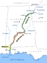
, is formed by the Tallapoosa
Tallapoosa River
The Tallapoosa River runs from the southern end of the Appalachian Mountains in Georgia, in the United States, southward and westward into Alabama. It is formed by the confluence of McClendon Creek and Mud Creek in Paulding County, Georgia. Lake Martin at Alexander City, Alabama is a large and...
and Coosa
Coosa River
The Coosa River is a tributary of the Alabama River in the U.S. states of Alabama and Georgia. The river is about long altogether.The Coosa River is one of Alabama's most developed rivers...
rivers, which unite about 6 miles (10 km) north of Montgomery
Montgomery, Alabama
Montgomery is the capital of the U.S. state of Alabama, and is the county seat of Montgomery County. It is located on the Alabama River southeast of the center of the state, in the Gulf Coastal Plain. As of the 2010 census, Montgomery had a population of 205,764 making it the second-largest city...
.
The river flows west to Selma
Selma, Alabama
Selma is a city in and the county seat of Dallas County, Alabama, United States, located on the banks of the Alabama River. The population was 20,512 at the 2000 census....
, then southwest until, about 45 miles (72.4 km) from Mobile
Mobile, Alabama
Mobile is the third most populous city in the Southern US state of Alabama and is the county seat of Mobile County. It is located on the Mobile River and the central Gulf Coast of the United States. The population within the city limits was 195,111 during the 2010 census. It is the largest...
, it unites with the Tombigbee
Tombigbee River
The Tombigbee River is a tributary of the Mobile River, approximately 200 mi long, in the U.S. states of Mississippi and Alabama. It is one of two major rivers, along with the Alabama River, that unite to form the short Mobile River before it empties into Mobile Bay on the Gulf of Mexico...
, forming the Mobile
Mobile River
The Mobile River is located in southern Alabama in the United States. Formed out of the confluence of the Tombigbee and Alabama rivers, the approximately river drains an area of of Alabama, with a watershed extending into Mississippi, Georgia, and Tennessee. Its drainage basin is the...
and Tensaw
Tensaw River
The Tensaw River is a distributary of the Mobile River, approximately 36 mi long, in southern Alabama in the United States. It is formed as a bayou of the Mobile approximately 6 mi south of the formation of the Mobile by the confluence of the Tombigbee and Alabama rivers...
rivers, which discharge into Mobile Bay
Mobile Bay
Mobile Bay is an inlet of the Gulf of Mexico, lying within the state of Alabama in the United States. Its mouth is formed by the Fort Morgan Peninsula on the eastern side and Dauphin Island, a barrier island on the western side. The Mobile River and Tensaw River empty into the northern end of the...
.
The course of the Alabama is very meandering. Its width varies from 50 to 200 yd (45.7 to 182.9 ), and its depth from 3 to 40 ft (0.9144 to 12.2 ).
Unanswered Questions
Discussions