

Hydrological transport model
Encyclopedia
Mathematical model
A mathematical model is a description of a system using mathematical concepts and language. The process of developing a mathematical model is termed mathematical modeling. Mathematical models are used not only in the natural sciences and engineering disciplines A mathematical model is a...
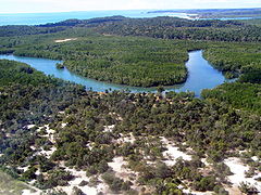
used to simulate river or stream flow and calculate water quality
Water quality
Water quality is the physical, chemical and biological characteristics of water. It is a measure of the condition of water relative to the requirements of one or more biotic species and or to any human need or purpose. It is most frequently used by reference to a set of standards against which...
parameters. These models generally came into use in the 1960s and 1970s when demand for numerical forecasting of water quality was driven by environmental legislation, and at a similar time widespread access to significant computer power became available. Much of the original model development took place in the United States
United States
The United States of America is a federal constitutional republic comprising fifty states and a federal district...
and United Kingdom
United Kingdom
The United Kingdom of Great Britain and Northern IrelandIn the United Kingdom and Dependencies, other languages have been officially recognised as legitimate autochthonous languages under the European Charter for Regional or Minority Languages...
, but today these models are refined and used worldwide.
There are dozens of different transport models that can be generally grouped by pollutants
Water pollution
Water pollution is the contamination of water bodies . Water pollution occurs when pollutants are discharged directly or indirectly into water bodies without adequate treatment to remove harmful compounds....
addressed, complexity of pollutant sources, whether the model is steady state or dynamic, and time period modeled. Another important designation is whether the model is distributed (i.e. capable of predicting multiple points within a river) or lumped. In a basic model, for example, only one pollutant might be addressed from a simple point discharge into the receiving waters. In the most complex of models, various line source
Line source
A line source is a source of air, noise, water contamination or electromagnetic radiation that emanates from a linear geometry...
inputs from surface runoff
Surface runoff
Surface runoff is the water flow that occurs when soil is infiltrated to full capacity and excess water from rain, meltwater, or other sources flows over the land. This is a major component of the water cycle. Runoff that occurs on surfaces before reaching a channel is also called a nonpoint source...
might be added to multiple point source
Point source (pollution)
A point source of pollution is a single identifiable localized source of air, water, thermal, noise or light pollution. A point source has negligible extent, distinguishing it from other pollution source geometries. The sources are called point sources because in mathematical modeling, they can be...
s, treating a variety of chemicals plus sediment
Sediment
Sediment is naturally occurring material that is broken down by processes of weathering and erosion, and is subsequently transported by the action of fluids such as wind, water, or ice, and/or by the force of gravity acting on the particle itself....
in a dynamic environment including vertical river stratification and interactions of pollutants with in-stream biota
Biota (ecology)
Biota are the total collection of organisms of a geographic region or a time period, from local geographic scales and instantaneous temporal scales all the way up to whole-planet and whole-timescale spatiotemporal scales. The biota of the Earth lives in the biosphere.-See...
. In addition watershed
Drainage basin
A drainage basin is an extent or an area of land where surface water from rain and melting snow or ice converges to a single point, usually the exit of the basin, where the waters join another waterbody, such as a river, lake, reservoir, estuary, wetland, sea, or ocean...
groundwater
Groundwater
Groundwater is water located beneath the ground surface in soil pore spaces and in the fractures of rock formations. A unit of rock or an unconsolidated deposit is called an aquifer when it can yield a usable quantity of water. The depth at which soil pore spaces or fractures and voids in rock...
may also be included. The model is termed "physically based" if its parameters can be measured in the field.
Often models have separate modules to address individual steps in the simulation process. The most common module is a subroutine
Subroutine
In computer science, a subroutine is a portion of code within a larger program that performs a specific task and is relatively independent of the remaining code....
for calculation of surface runoff, allowing variation in land use
Land use
Land use is the human use of land. Land use involves the management and modification of natural environment or wilderness into built environment such as fields, pastures, and settlements. It has also been defined as "the arrangements, activities and inputs people undertake in a certain land cover...
type, topography
Topography
Topography is the study of Earth's surface shape and features or those ofplanets, moons, and asteroids...
, soil
Soil
Soil is a natural body consisting of layers of mineral constituents of variable thicknesses, which differ from the parent materials in their morphological, physical, chemical, and mineralogical characteristics...
type, vegetative cover
Vegetation
Vegetation is a general term for the plant life of a region; it refers to the ground cover provided by plants. It is a general term, without specific reference to particular taxa, life forms, structure, spatial extent, or any other specific botanical or geographic characteristics. It is broader...
, precipitation
Precipitation (meteorology)
In meteorology, precipitation In meteorology, precipitation In meteorology, precipitation (also known as one of the classes of hydrometeors, which are atmospheric water phenomena is any product of the condensation of atmospheric water vapor that falls under gravity. The main forms of precipitation...
and land management practice (such as the application rate of a fertilizer
Fertilizer
Fertilizer is any organic or inorganic material of natural or synthetic origin that is added to a soil to supply one or more plant nutrients essential to the growth of plants. A recent assessment found that about 40 to 60% of crop yields are attributable to commercial fertilizer use...
). The concept of hydrological modeling can be extended to other environments such as the ocean
Ocean
An ocean is a major body of saline water, and a principal component of the hydrosphere. Approximately 71% of the Earth's surface is covered by ocean, a continuous body of water that is customarily divided into several principal oceans and smaller seas.More than half of this area is over 3,000...
s, but most commonly (and in this article) the subject of a river watershed is generally implied.
History
In 1850, T. J. Mulvany was probably the first investigator to use mathematical modeling in a stream hydrology context, although there was no chemistry involved. By 1892 M.E. Imbeau had conceived an event model to relate runoff to peak rainfall, again still with no chemistry. Robert E. HortonRobert E. Horton
Robert Elmer Horton was an American ecologist and soil scientist, considered by many to be the father of modern hydrology....
’s seminal work on surface runoff
Surface runoff
Surface runoff is the water flow that occurs when soil is infiltrated to full capacity and excess water from rain, meltwater, or other sources flows over the land. This is a major component of the water cycle. Runoff that occurs on surfaces before reaching a channel is also called a nonpoint source...
along with his coupling of quantitative treatment of erosion laid the groundwork for modern chemical transport hydrology.
Physically based models
Physically based models (sometimes known as deterministic, comprehensive or process-based models) try to represent the physical processes observed in the real world. Typically, such models contain representations of surface runoff, subsurface flow, evapotranspiration, and channel flow, but they can be far more complicated. "Large scale simulation experiments were begun by the Corps of Engineers in 1953 for reservoir management on the main stem of the Missouri River". This, and other early work that dealt with the River Nile and the Columbia River are discussed, in a wider context, in a book published by the Harvard Water Resources Seminar, that contains the sentence just quoted.Another early model that integrated many submodels for basin chemical hydrology was the Stanford Watershed Model (SWM). The SWMM (Storm Water Management Model
Storm Water Management Model
The United States Environmental Protection Agency Storm Water Management Model is a dynamic rainfall-runoff-subsurface runoff simulation model used for single-event to long-term simulation of the surface/subsurface hydrology quantity and quality from primarily urban/suburban areas...
), the HSPF (Hydrological Simulation Program - FORTRAN) and other modern American
United States
The United States of America is a federal constitutional republic comprising fifty states and a federal district...
derivatives are successors to this early work.
In Europe a favoured comprehensive model is the Système Hydrologique Européen (SHE), which has been succeeded by MIKE SHE
MIKE SHE
MIKE SHE is an integrated hydrological modelling system for building and simulating surface water flow and groundwater flow. MIKE SHE can simulate the entire land phase of the hydrologic cycle and allows components to be used independently and customized to local needs...
and SHETRAN
SHETRAN
SHETRAN is a hydrological modelling system for water flow, solute and sediment transport in river catchments. SHETRAN is a physically based, distributed model that can simulate the entire land phase of the hydrologic cycle including surface water flow and groundwater flow...
. MIKE SHE
MIKE SHE
MIKE SHE is an integrated hydrological modelling system for building and simulating surface water flow and groundwater flow. MIKE SHE can simulate the entire land phase of the hydrologic cycle and allows components to be used independently and customized to local needs...
is a watershed-scale physically based, spatially distributed model for water flow and sediment transport
Sediment transport
Sediment transport is the movement of solid particles , typically due to a combination of the force of gravity acting on the sediment, and/or the movement of the fluid in which the sediment is entrained...
. Flow and transport processes are represented by either finite difference representations of partial differential equation
Differential equation
A differential equation is a mathematical equation for an unknown function of one or several variables that relates the values of the function itself and its derivatives of various orders...
s or by derived empirical equations. The following principal submodels are involved:
- EvapotranspirationEvapotranspirationEvapotranspiration is a term used to describe the sum of evaporation and plant transpiration from the Earth's land surface to atmosphere. Evaporation accounts for the movement of water to the air from sources such as the soil, canopy interception, and waterbodies...
: Penman-MonteithPenman-MonteithLike the Penman equation, the Penman–Monteith equation predicts net evapotranspiration, requiring as input daily mean temperature, wind speed, relative humidity, and solar radiation...
formalism - Erosion: Detachment equations for raindrop and overland flow
- Overland and ChannelChannel (geography)In physical geography, a channel is the physical confine of a river, slough or ocean strait consisting of a bed and banks.A channel is also the natural or human-made deeper course through a reef, sand bar, bay, or any shallow body of water...
Flow: Saint-Venant equations of continuity and momentumMomentumIn classical mechanics, linear momentum or translational momentum is the product of the mass and velocity of an object... - Overland Flow SedimentSedimentSediment is naturally occurring material that is broken down by processes of weathering and erosion, and is subsequently transported by the action of fluids such as wind, water, or ice, and/or by the force of gravity acting on the particle itself....
Transport: 2D total sediment load conservation equation - Unsaturated Flow: Richards equationRichards equationThe Richards equation represents the movement of water in unsaturated soils, and was formulated by Lorenzo A. Richards in 1931 . It is a non-linear partial differential equation, which is often difficult to approximate since it does not have a closed-form analytical solution.Darcy's law was...
- Saturated Flow: Darcy's lawDarcy's lawDarcy's law is a phenomenologically derived constitutive equation that describes the flow of a fluid through a porous medium. The law was formulated by Henry Darcy based on the results of experiments on the flow of water through beds of sand...
and the mass conservationConservation of massThe law of conservation of mass, also known as the principle of mass/matter conservation, states that the mass of an isolated system will remain constant over time...
of 2D laminar flow - Channel Sediment Transport 1D mass conservation equation.
This model can analyze effects of land use
Land use
Land use is the human use of land. Land use involves the management and modification of natural environment or wilderness into built environment such as fields, pastures, and settlements. It has also been defined as "the arrangements, activities and inputs people undertake in a certain land cover...
and climate change
Climate change
Climate change is a significant and lasting change in the statistical distribution of weather patterns over periods ranging from decades to millions of years. It may be a change in average weather conditions or the distribution of events around that average...
s upon in-stream water quality, with consideration of groundwater
Groundwater
Groundwater is water located beneath the ground surface in soil pore spaces and in the fractures of rock formations. A unit of rock or an unconsolidated deposit is called an aquifer when it can yield a usable quantity of water. The depth at which soil pore spaces or fractures and voids in rock...
interactions.
Worldwide a number of basin models have been developed, among them RORB (Australia
Australia
Australia , officially the Commonwealth of Australia, is a country in the Southern Hemisphere comprising the mainland of the Australian continent, the island of Tasmania, and numerous smaller islands in the Indian and Pacific Oceans. It is the world's sixth-largest country by total area...
), Xinanjiang (China
China
Chinese civilization may refer to:* China for more general discussion of the country.* Chinese culture* Greater China, the transnational community of ethnic Chinese.* History of China* Sinosphere, the area historically affected by Chinese culture...
), Tank model (Japan
Japan
Japan is an island nation in East Asia. Located in the Pacific Ocean, it lies to the east of the Sea of Japan, China, North Korea, South Korea and Russia, stretching from the Sea of Okhotsk in the north to the East China Sea and Taiwan in the south...
), ARNO (Italy
Italy
Italy , officially the Italian Republic languages]] under the European Charter for Regional or Minority Languages. In each of these, Italy's official name is as follows:;;;;;;;;), is a unitary parliamentary republic in South-Central Europe. To the north it borders France, Switzerland, Austria and...
), TOPMODEL (Europe
Europe
Europe is, by convention, one of the world's seven continents. Comprising the westernmost peninsula of Eurasia, Europe is generally 'divided' from Asia to its east by the watershed divides of the Ural and Caucasus Mountains, the Ural River, the Caspian and Black Seas, and the waterways connecting...
), UBC (Canada
Canada
Canada is a North American country consisting of ten provinces and three territories. Located in the northern part of the continent, it extends from the Atlantic Ocean in the east to the Pacific Ocean in the west, and northward into the Arctic Ocean...
) and HBV
HBV hydrology model
The HBV hydrology model, or Hydrologiska Byråns Vattenbalansavdelning model, is a computer simulation used to analyze river discharge and water pollution...
(Scandinavia
Scandinavia
Scandinavia is a cultural, historical and ethno-linguistic region in northern Europe that includes the three kingdoms of Denmark, Norway and Sweden, characterized by their common ethno-cultural heritage and language. Modern Norway and Sweden proper are situated on the Scandinavian Peninsula,...
), MOHID Land
MOHID Land
MOHID Land is the hydrology module within the three-dimensional MOHID Water Modelling System. MOHID is an integrated system for water flow, consisting of three main modules: Water for three-dimensional fluid dynamics, Land for hydrology and Soil for groundwater flow...
(Portugal
Portugal
Portugal , officially the Portuguese Republic is a country situated in southwestern Europe on the Iberian Peninsula. Portugal is the westernmost country of Europe, and is bordered by the Atlantic Ocean to the West and South and by Spain to the North and East. The Atlantic archipelagos of the...
). However, not all these models have a chemistry component. Generally speaking, SWM, SHE and TOPMODEL have the most comprehensive stream chemistry treatment and have evolved to accommodate the latest data sources including remote sensing
Remote sensing
Remote sensing is the acquisition of information about an object or phenomenon, without making physical contact with the object. In modern usage, the term generally refers to the use of aerial sensor technologies to detect and classify objects on Earth by means of propagated signals Remote sensing...
and geographic information system
Geographic Information System
A geographic information system, geographical information science, or geospatial information studies is a system designed to capture, store, manipulate, analyze, manage, and present all types of geographically referenced data...
data.
In the United States, the U.S. Army Corps of Engineers, Engineer Research and Development Center in conjunction with a researchers at a number of universities have developed the Gridded Surface/Subsurface Hydrologic Analysis GSSHA
GSSHA
Gridded Surface/Subsurface Hydrologic Analysis ModelGSSHA is the U.S. Army Corps of Engineers, Engineer Research and Development Center two-dimensional, physically based, watershed model. GSSHA is a mathematical model that simulates surface and ground water hydrology, erosion and sediment transport...
model. GSSHA
GSSHA
Gridded Surface/Subsurface Hydrologic Analysis ModelGSSHA is the U.S. Army Corps of Engineers, Engineer Research and Development Center two-dimensional, physically based, watershed model. GSSHA is a mathematical model that simulates surface and ground water hydrology, erosion and sediment transport...
is widely used in the U.S. for research and analysis by U.S. Army Corps of Engineers districts and larger consulting companies to compute flow, water levels, distributed erosion, and sediment delivery in complex engineering
Engineering
Engineering is the discipline, art, skill and profession of acquiring and applying scientific, mathematical, economic, social, and practical knowledge, in order to design and build structures, machines, devices, systems, materials and processes that safely realize improvements to the lives of...
designs. A distributed nutrient and contaminant fate and transport component is undergoing testing. GSSHA
GSSHA
Gridded Surface/Subsurface Hydrologic Analysis ModelGSSHA is the U.S. Army Corps of Engineers, Engineer Research and Development Center two-dimensional, physically based, watershed model. GSSHA is a mathematical model that simulates surface and ground water hydrology, erosion and sediment transport...
input/output processing and interface with GIS is facilitated by the Watershed Modeling System (WMS).
Another model used in the United States and worldwide is Vflo
Vflo
Vflo is a commercially available, physics-based distributed hydrologic model generated by Vflo uses radar rainfall data for hydrologic input to simulate distributed runoff . Vflo employs GIS maps for parameterization via a desktop interface . The model is suited for distributed hydrologic...
, a physics-based distributed hydrologic model developed by Vieux & Associates, Inc. Vflo employs radar rainfall and GIS data to compute spatially distributed overland flow and channel flow. Evapotranspiration, inundation, infiltration, and snowmelt modeling capabilities are included. Applications include civil infrastructure operations and maintenance, stormwater prediction and emergency management, soil moisture monitoring, land use planning, water quality monitoring, and others.
Stochastic models
These models based on data are black box systems, using mathematical and statistical concepts to link a certain input (for instance rainfall) to the model output (for instance runoffSurface runoff
Surface runoff is the water flow that occurs when soil is infiltrated to full capacity and excess water from rain, meltwater, or other sources flows over the land. This is a major component of the water cycle. Runoff that occurs on surfaces before reaching a channel is also called a nonpoint source...
). Commonly used techniques are regression
Regression analysis
In statistics, regression analysis includes many techniques for modeling and analyzing several variables, when the focus is on the relationship between a dependent variable and one or more independent variables...
, transfer function
Transfer function
A transfer function is a mathematical representation, in terms of spatial or temporal frequency, of the relation between the input and output of a linear time-invariant system. With optical imaging devices, for example, it is the Fourier transform of the point spread function i.e...
s, neural networks
Neural Networks
Neural Networks is the official journal of the three oldest societies dedicated to research in neural networks: International Neural Network Society, European Neural Network Society and Japanese Neural Network Society, published by Elsevier...
and system identification
System identification
In control engineering, the field of system identification uses statistical methods to build mathematical models of dynamical systems from measured data...
. These models are known as stochastic hydrology models. Data based models have been used within hydrology to simulate the rainfall-runoff relationship, represent the impacts of antecedent moisture
Antecedent moisture
Antecedent moisture is a term from the fields of Hydrology and sewage collection and disposal that describes the relative wetness or dryness of a watershed or sanitary sewershed. Antecedent moisture conditions change continuously and can have a very significant effect on the flow responses in...
and perform real-time control on systems.
Surface runoff modelling
A key component of a hydrological transport model is the surface runoffSurface runoff
Surface runoff is the water flow that occurs when soil is infiltrated to full capacity and excess water from rain, meltwater, or other sources flows over the land. This is a major component of the water cycle. Runoff that occurs on surfaces before reaching a channel is also called a nonpoint source...
element, which allows assessment of sediment, fertilizer
Fertilizer
Fertilizer is any organic or inorganic material of natural or synthetic origin that is added to a soil to supply one or more plant nutrients essential to the growth of plants. A recent assessment found that about 40 to 60% of crop yields are attributable to commercial fertilizer use...
, pesticide
Pesticide
Pesticides are substances or mixture of substances intended for preventing, destroying, repelling or mitigating any pest.A pesticide may be a chemical unicycle, biological agent , antimicrobial, disinfectant or device used against any pest...
and other chemical contaminants. Building on the work of Horton, the unit hydrograph theory was developed by Dooge in 1959. It required the presence of the National Environmental Policy Act
National Environmental Policy Act
The National Environmental Policy Act is a United States environmental law that established a U.S. national policy promoting the enhancement of the environment and also established the President's Council on Environmental Quality ....
and kindred other national legislation to provide the impetus to integrate water chemistry to hydrology model protocols. In the early 1970s the U.S. Environmental Protection Agency
United States Environmental Protection Agency
The U.S. Environmental Protection Agency is an agency of the federal government of the United States charged with protecting human health and the environment, by writing and enforcing regulations based on laws passed by Congress...
(EPA) began sponsoring a series of water quality models in response to the Clean Water Act
Clean Water Act
The Clean Water Act is the primary federal law in the United States governing water pollution. Commonly abbreviated as the CWA, the act established the goals of eliminating releases of high amounts of toxic substances into water, eliminating additional water pollution by 1985, and ensuring that...
. An example of these efforts was developed at the Southeast Water Laboratory, one of the first attempts to calibrate a surface runoff model with field data for a variety of chemical contaminants.
The attention given to surface runoff contaminant models has not matched the emphasis on pure hydrology models, in spite of their role in the generation of stream loading contaminant data. In the United States the EPA has had difficulty interpreting diverse proprietary contaminant models and has to develop its own models more often than conventional resource agencies, who, focused on flood
Flood
A flood is an overflow of an expanse of water that submerges land. The EU Floods directive defines a flood as a temporary covering by water of land not normally covered by water...
forecasting, have had more of a centroid of common basin models.
Example applications
Liden applied the HBV modelHBV hydrology model
The HBV hydrology model, or Hydrologiska Byråns Vattenbalansavdelning model, is a computer simulation used to analyze river discharge and water pollution...
to estimate the riverine transport of three different substances, nitrogen
Nitrogen
Nitrogen is a chemical element that has the symbol N, atomic number of 7 and atomic mass 14.00674 u. Elemental nitrogen is a colorless, odorless, tasteless, and mostly inert diatomic gas at standard conditions, constituting 78.08% by volume of Earth's atmosphere...
, phosphorus
Phosphorus
Phosphorus is the chemical element that has the symbol P and atomic number 15. A multivalent nonmetal of the nitrogen group, phosphorus as a mineral is almost always present in its maximally oxidized state, as inorganic phosphate rocks...
and suspended sediment in four different countries: Sweden
Sweden
Sweden , officially the Kingdom of Sweden , is a Nordic country on the Scandinavian Peninsula in Northern Europe. Sweden borders with Norway and Finland and is connected to Denmark by a bridge-tunnel across the Öresund....
, Estonia
Estonia
Estonia , officially the Republic of Estonia , is a state in the Baltic region of Northern Europe. It is bordered to the north by the Gulf of Finland, to the west by the Baltic Sea, to the south by Latvia , and to the east by Lake Peipsi and the Russian Federation . Across the Baltic Sea lies...
, Bolivia
Bolivia
Bolivia officially known as Plurinational State of Bolivia , is a landlocked country in central South America. It is the poorest country in South America...
and Zimbabwe
Zimbabwe
Zimbabwe is a landlocked country located in the southern part of the African continent, between the Zambezi and Limpopo rivers. It is bordered by South Africa to the south, Botswana to the southwest, Zambia and a tip of Namibia to the northwest and Mozambique to the east. Zimbabwe has three...
. The relation between internal hydrological model variables and nutrient
Nutrient
A nutrient is a chemical that an organism needs to live and grow or a substance used in an organism's metabolism which must be taken in from its environment. They are used to build and repair tissues, regulate body processes and are converted to and used as energy...
transport was assessed. A model for nitrogen
Nitrogen
Nitrogen is a chemical element that has the symbol N, atomic number of 7 and atomic mass 14.00674 u. Elemental nitrogen is a colorless, odorless, tasteless, and mostly inert diatomic gas at standard conditions, constituting 78.08% by volume of Earth's atmosphere...
sources was developed and analysed in comparison with a statistical method. A model for suspended sediment transport in tropical and semi-arid
Semi-arid
A semi-arid climate or steppe climate describes climatic regions that receive precipitation below potential evapotranspiration, but not extremely...
regions was developed and tested. It was shown that riverine total nitrogen could be well simulated in the Nordic
Nordic countries
The Nordic countries make up a region in Northern Europe and the North Atlantic which consists of Denmark, Finland, Iceland, Norway and Sweden and their associated territories, the Faroe Islands, Greenland and Åland...
climate and riverine suspended sediment load could be estimated fairly well in tropical and semi-arid climates. The HBV model for material transport generally estimated material transport loads well. The main conclusion of the study was that the HBV model can be used to predict material transport on the scale of the drainage basin
Drainage basin
A drainage basin is an extent or an area of land where surface water from rain and melting snow or ice converges to a single point, usually the exit of the basin, where the waters join another waterbody, such as a river, lake, reservoir, estuary, wetland, sea, or ocean...
during stationary conditions, but cannot be easily generalised to areas not specifically calibrated. In a different work, Castanedo et al. applied an evolutionary algorithm to automated watershed model calibration.
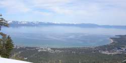
DSSAM Model
The DSSAM Model is a computer simulation developed for the Truckee River to analyze water quality impacts from land use and wastewater management decisions in the Truckee River Basin. This area includes the cities of Reno and Sparks, Nevada as well as the Lake Tahoe Basin...
to analyze water quality
Water pollution
Water pollution is the contamination of water bodies . Water pollution occurs when pollutants are discharged directly or indirectly into water bodies without adequate treatment to remove harmful compounds....
impacts from land use
Land use
Land use is the human use of land. Land use involves the management and modification of natural environment or wilderness into built environment such as fields, pastures, and settlements. It has also been defined as "the arrangements, activities and inputs people undertake in a certain land cover...
and wastewater
Wastewater
Wastewater is any water that has been adversely affected in quality by anthropogenic influence. It comprises liquid waste discharged by domestic residences, commercial properties, industry, and/or agriculture and can encompass a wide range of potential contaminants and concentrations...
management decisions in the Truckee River
Truckee River
The Truckee River is a stream in the U.S. states of California and Nevada. The river is about long. Its endorheic drainage basin is about , of which about are in Nevada. The Truckee is the sole outlet of Lake Tahoe and drains part of the high Sierra Nevada, emptying into Pyramid Lake in the Great...
basin, an area which include the cities of Reno
Reno, Nevada
Reno is the county seat of Washoe County, Nevada, United States. The city has a population of about 220,500 and is the most populous Nevada city outside of the Las Vegas metropolitan area...
and Sparks, Nevada
Sparks, Nevada
Sparks is a city in Washoe County, Nevada, United States, located east of Reno, Nevada. The 2010 U.S. Census Bureau population count was 90,264. Sparks is often referred to as half of a twin city .-Geography and Climate:...
as well as the Lake Tahoe
Lake Tahoe
Lake Tahoe is a large freshwater lake in the Sierra Nevada of the United States. At a surface elevation of , it is located along the border between California and Nevada, west of Carson City. Lake Tahoe is the largest alpine lake in North America. Its depth is , making it the USA's second-deepest...
basin. The model satisfactorily predicted nutrient, sediment and dissolved oxygen parameters in the river. It is based on a pollutant loading metric
Metric (mathematics)
In mathematics, a metric or distance function is a function which defines a distance between elements of a set. A set with a metric is called a metric space. A metric induces a topology on a set but not all topologies can be generated by a metric...
called "Total Daily Maximum Load" (TDML). The success of this model contributed to the EPA’s commitment to the use of the underlying TDML protocol in EPA’s national policy for management of many river systems in the United States
United States
The United States of America is a federal constitutional republic comprising fifty states and a federal district...
.
The DSSAM Model is constructed to allow dynamic decay of most pollutants; for example, total nitrogen and phosphorus are allowed to be consumed by benthic
Benthic zone
The benthic zone is the ecological region at the lowest level of a body of water such as an ocean or a lake, including the sediment surface and some sub-surface layers. Organisms living in this zone are called benthos. They generally live in close relationship with the substrate bottom; many such...
algae in each time step, and the algal communities are given a separate population dynamic in each river reach (e.g. based upon river temperature). Regarding stormwater runoff in Washoe County
Washoe County, Nevada
Washoe County is a county located in the U.S. state of Nevada. The population was 421,407 at the 2010 census. Its county seat is Reno. Washoe County includes the Reno-Sparks metropolitan area.-History:...
, the specific elements within a new xeriscape ordinance were analyzed for efficacy using the model. For the varied agricultural uses in the watershed, the model was run to understand the principal sources of impact, and management practices were developed to reduce in-river pollution. Use of the model has specifically been conducted to analyze survival of two endangered species
Endangered species
An endangered species is a population of organisms which is at risk of becoming extinct because it is either few in numbers, or threatened by changing environmental or predation parameters...
found in the Truckee River
Truckee River
The Truckee River is a stream in the U.S. states of California and Nevada. The river is about long. Its endorheic drainage basin is about , of which about are in Nevada. The Truckee is the sole outlet of Lake Tahoe and drains part of the high Sierra Nevada, emptying into Pyramid Lake in the Great...
and Pyramid Lake: the Cui-ui
Cui-ui
The cui-ui, Chasmistes cujus, is a large sucker fish endemic to Pyramid Lake and, prior to its desiccation in the 20th century, Winnemucca Lake in northwestern Nevada. It feeds primarily on zooplankton and possibly on nanoplankton...
sucker fish
Catostomidae
Catostomidae is the sucker family of the order Cypriniformes. There are 80 species in this family of freshwater fishes. Catostomidae are found in North America, east central China, and eastern Siberia...
and the Lahontan cutthroat trout
Lahontan cutthroat trout
Lahontan cutthroat trout is the largest subspecies of cutthroat trout, and the state fish of Nevada.-Natural history:...
.
See also
- AquiferAquiferAn aquifer is a wet underground layer of water-bearing permeable rock or unconsolidated materials from which groundwater can be usefully extracted using a water well. The study of water flow in aquifers and the characterization of aquifers is called hydrogeology...
- Differential equationDifferential equationA differential equation is a mathematical equation for an unknown function of one or several variables that relates the values of the function itself and its derivatives of various orders...
- HBV modelHBV hydrology modelThe HBV hydrology model, or Hydrologiska Byråns Vattenbalansavdelning model, is a computer simulation used to analyze river discharge and water pollution...
- HydrometryHydrometryHydrometry is the monitoring of the components of the hydrological cycle including rainfall, groundwater characteristics, as well as water quality and flow characteristics of surface waters...
- InfiltrationInfiltration (hydrology)Infiltration is the process by which water on the ground surface enters the soil. Infiltration rate in soil science is a measure of the rate at which soil is able to absorb rainfall or irrigation. It is measured in inches per hour or millimeters per hour. The rate decreases as the soil becomes...
- Runoff model (reservoir)Runoff model (reservoir)A runoff model is a mathematical model describing the rainfall - runoff relations of a rainfall catchment area, drainage basin or watershed. More precisely, it produces the surface runoff hydrograph as a response to a rainfall hydrograph as input...
- Stormwater Management Model
- United States Army Corps of EngineersUnited States Army Corps of EngineersThe United States Army Corps of Engineers is a federal agency and a major Army command made up of some 38,000 civilian and military personnel, making it the world's largest public engineering, design and construction management agency...
- WAFLEX modelWAFLEXWAFLEX is a spreadsheet-based model. It can be used to analyse upstream-downstream interactions, dam management options and water allocation and development options.-Structure of the Model:...