
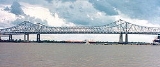
Crescent City Connection
Encyclopedia
Cantilever bridge
A cantilever bridge is a bridge built using cantilevers, structures that project horizontally into space, supported on only one end. For small footbridges, the cantilevers may be simple beams; however, large cantilever bridges designed to handle road or rail traffic use trusses built from...
s that carry U.S. Route 90 Business
U.S. Route 90 Business (New Orleans, Louisiana)
U.S. Highway 90 Business is a business route of U.S. Highway 90 in and near New Orleans, Louisiana, United States. Unlike a standard business route, it is built to higher standards than the segment of U.S. 90 that it parallels, with over half built to freeway standards and designated Interstate 910...
over the Mississippi River
Mississippi River
The Mississippi River is the largest river system in North America. Flowing entirely in the United States, this river rises in western Minnesota and meanders slowly southwards for to the Mississippi River Delta at the Gulf of Mexico. With its many tributaries, the Mississippi's watershed drains...
in New Orleans, Louisiana
Louisiana
Louisiana is a state located in the southern region of the United States of America. Its capital is Baton Rouge and largest city is New Orleans. Louisiana is the only state in the U.S. with political subdivisions termed parishes, which are local governments equivalent to counties...
, United States
United States
The United States of America is a federal constitutional republic comprising fifty states and a federal district...
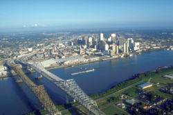
. They are tied as the fifth-longest cantilever bridges in the world. Each span carries four general-use automobile lanes; additionally the westbound span has two reversible HOV lanes across the river. The westbound span, which carries motorists into the city's Central Business District
New Orleans Central Business District
The Central Business District is a neighborhood of the city of New Orleans. A subdistrict of the French Quarter/CBD Area, its boundaries as defined by the City Planning Commission are: Iberville, Decatur and Canal Streets to the north, the Mississippi River to the east, the New Orleans Morial...
on the Eastbank, requires a toll of $1 ($0.40 with an electronic toll tag).
It is the farthest downstream bridge on the Mississippi River. It is also the widest and most heavily-traveled bridge on the lower Mississippi; the only other comparable bridges on the Mississippi are in the Minneapolis-St. Paul area (the I-35W Saint Anthony Falls Bridge, the Dartmouth Bridge
Dartmouth Bridge
The Dartmouth Bridge is a steel girder bridge that spans the Mississippi River in Minneapolis, Minnesota, between the Cedar-Riverside area and the University of Minnesota campus area. It was built in 1964 and was designed by Parsons Brinckerhoff, Quade and Douglas.The original span was an...
, and once fully expanded, the Wakota Bridge
Wakota Bridge
-External links:***...
).
History
What later became known as the Crescent City Connection was the second bridge to span the Mississippi south of Baton RougeBaton Rouge, Louisiana
Baton Rouge is the capital of the U.S. state of Louisiana. It is located in East Baton Rouge Parish and is the second-largest city in the state.Baton Rouge is a major industrial, petrochemical, medical, and research center of the American South...
after the Huey P. Long Bridge
Huey P. Long Bridge (Jefferson Parish)
The Huey P. Long Bridge in Jefferson Parish, Louisiana, is a cantilevered steel through truss bridge that carries a two-track railroad line over the Mississippi River at mile 106.1 with two lanes of US 90 on each side of the central tracks....
a few miles up river from the city, and the first bridge across the river in New Orleans itself.
The Mississippi River Bridge Authority, known since 1989 as the Crescent City Connection Division
Crescent City Connection Division
The Crescent City Connection Division is an agency within the Louisiana Department of Transportation and Development. The purpose of the CCCD is to plan, construct, operate, maintain and police all Mississippi River crossings in Jefferson, Orleans, and St. Bernard Parishes...
(CCCD), began construction of the first span in November 1954, which opened in April 1958 as the Greater New Orleans Bridge. At its opening, the bridge was the longest cantilever bridge in the world, although in terms of main span length it was third after the Forth Bridge
Forth Bridge (railway)
The Forth Bridge is a cantilever railway bridge over the Firth of Forth in the east of Scotland, to the east of the Forth Road Bridge, and 14 kilometres west of central Edinburgh. It was opened on 4 March 1890, and spans a total length of...
and the Quebec Bridge
Quebec Bridge
right|thumb|Lifting the centre span in place was considered to be a major engineering achievement. Photo caption from [[Popular Mechanics]] Magazine, December 1917...
. It carried two lanes of traffic in each direction, and spurred growth in the suburban area known as the West Bank (for its location on the western bank of the river; it is geographically southeast of New Orleans). Construction of the second span began in March 1981. Despite promises that it would be ready for the 1984 Louisiana World Exposition
1984 Louisiana World Exposition
The 1984 Louisiana World Exposition was a World's Fair held in New Orleans, Louisiana. It was held 100 years after the city's earlier World's Fair, the World Cotton Centennial in 1884. It opened on Saturday, May 12, 1984 and ended on Sunday, November 11, 1984...
, it did not open to traffic until September 1988. The second span was originally designated as the Greater New Orleans Bridge No. 2. Both bridges were designed by Modjeski & Masters, Inc.. As soon as the new span was opened, the old span was temporarily closed in phases to replace the asphalt-on-steel deck with concrete. All the exits and entrances to the bridge were replaced as well.
After completion of the second span, a public contest was held in 1989 to rename the bridges, which was won by Jennifer Grodsky of St. Clement of Rome School in Metairie
Metairie, Louisiana
Metairie is a census-designated place in Jefferson Parish, Louisiana, United States and is a major part of the New Orleans Metropolitan Area. Metairie is the largest community in Jefferson Parish. It is an unincorporated area that would be larger than most of the state's cities if it were...
, Louisiana
Louisiana
Louisiana is a state located in the southern region of the United States of America. Its capital is Baton Rouge and largest city is New Orleans. Louisiana is the only state in the U.S. with political subdivisions termed parishes, which are local governments equivalent to counties...
, on March 17. The name was selected over the second place finisher, the Greater New Orleans Superspan, as the name for the spans. Other names voted on for the naming of the spans included: the Crescent City Twins, the Delta Twins, the Crescent City Bridge, the New Orleans Metro Span, the Crescent City Gateway, the Crescent City Twin Span, the Crescent City River Bridge, The Big Easy and the Li'l Easy, the Jazz City Bridge, the Big East Twin Spans, The Pelican Bridge, the Fleur-de-Lis, the Greater Mississippi River Bridge, the Unity Bridge, the Mississippi River Twins, The Friendship Connection, The Pelican Pride, the Riverview Bridge, the Creole Crossing, the Jazz Gate Bridge, the Greater New Orleans Twin Bridges and the Crescent Bend Bridge.
Following this contest, the Louisiana Legislature officially designated the bridges as the Crescent City Connection. It is maintained and policed by the CCCD, a special division of the Louisiana Department of Transportation and Development
Louisiana Department of Transportation and Development
The Louisiana Department of Transportation and Development is a state government organization in charge of maintaining public transportation, roadways, bridges, canals, select levees, floodplain management, port facilities, commercial vehicles, and aviation which includes 69 airports, in the U.S....
which since 1989 has controlled all Mississippi River crossings in Orleans, Jefferson
Jefferson Parish, Louisiana
Jefferson Parish is a parish in Louisiana, United States that includes most of the suburbs of New Orleans. The seat of parish government is Gretna....
, and St. Bernard Parish
St. Bernard Parish, Louisiana
St. Bernard Parish is a parish located southeast of New Orleans in the U.S. state of Louisiana. The parish seat is Chalmette, the largest city in the parish. As of 2000, its population was 67,229. It has been ranked the fastest-growing county in the United States from 2007 to 2008 by the U.S....
es. A separate police agency, commonly nicknamed the "Bridge Police," is required because of the high traffic volume and the fact that the two spans briefly cross into Jefferson Parish and the city of Gretna
Gretna, Louisiana
The city of Gretna is the parish seat of Jefferson Parish, in the US state of Louisiana. Gretna is on the west bank of the Mississippi River, just east and across the river from uptown New Orleans. It is part of the New Orleans–Metairie–Kenner Metropolitan Statistical Area...
; therefore, it could not be policed solely by the New Orleans Police Department
New Orleans Police Department
The New Orleans Police Department has primary responsibility for law enforcement in New Orleans, Louisiana. The department's jurisdiction covers all of Orleans Parish, while the city is divided into eight police districts....
.
Due to the Mississippi River's winding course through the New Orleans area (the river is flowing north at the place where the two bridges cross), the eastbound span actually carries Business US 90 West, while the westbound span carries Business US 90 East. The Crescent City Connection is the fifth most traveled toll bridge in the United States, with annual traffic exceeding 63 million vehicles (approximately 180,000 daily).
The bridge is the center piece of the Crescent Connection Road Race (CCRR) or Bridge Race as it is locally known, an annual event held on the first Saturday in September following Labor Day. The bridge remains open to vehicular traffic during the race, which only uses the two HOV lanes. The CCRR was originally started as a fundraiser for the bridge's decorative lights. These lights line the top profile lines of both bridges; 64 lights along each string for a total 256 lights.
Hurricane Katrina
As Hurricane KatrinaHurricane Katrina
Hurricane Katrina of the 2005 Atlantic hurricane season was a powerful Atlantic hurricane. It is the costliest natural disaster, as well as one of the five deadliest hurricanes, in the history of the United States. Among recorded Atlantic hurricanes, it was the sixth strongest overall...
approached the city in August 2005, the CCCD halted toll collections on August 26 to aid in speed of evacuation of the Metro area. Two overhead signs were blown down on the older span, but no other damage occurred to either bridge. After the storm passed, much of the east bank of New Orleans flooded severely (see Effect of Hurricane Katrina on New Orleans
Effect of Hurricane Katrina on New Orleans
The effects of Hurricane Katrina in New Orleans have been long-lasting. As the center of Katrina passed South-east of New Orleans on August 29, 2005, winds downtown were in the Category 3 range with frequent intense gusts and tidal surge. Hurricane force winds were experienced throughout the...
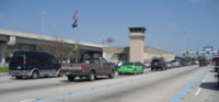
). With all other major and minor highways out of town flooded in both directions, the CCC was the only open highway into or out of the east bank of Orleans Parish. (One other route, Leake Avenue/Old River Road, a small road along the Mississippi River levee, was initially blocked by debris but was cleared by local volunteer work). Two days after the storm passed, the Gretna police setup a roadblock on the bridge, refusing passage to evacuees. A lawsuit alleges that the bridge was closed due to racism against the largely African-American evacuees, while the city maintains that they had no facilities or manpower to serve the evacuees.
In the initial weeks following the storm, only emergency personnel and contractors were permitted to use the bridge. The bridge reopened to traffic in mid-September as decreasing water levels on the East Bank of Orleans Parish allowed Interstate 10
Interstate 10
Interstate 10 is the fourth-longest Interstate Highway in the United States, after I-90, I-80, and I-40. It is the southernmost east–west, coast-to-coast Interstate Highway, although I-4 and I-8 are further south. It stretches from the Pacific Ocean at State Route 1 in Santa Monica,...
to reopen and residents to return, but then was temporarily closed to regular traffic again when another evacuation was declared due to Hurricane Rita
Hurricane Rita
Hurricane Rita was the fourth-most intense Atlantic hurricane ever recorded and the most intense tropical cyclone ever observed in the Gulf of Mexico. Rita caused $11.3 billion in damage on the U.S. Gulf Coast in September 2005...
, with the bridge again reopening in late September. Toll collection resumed on October 10, 2005 after a six-week suspension, as the revenue was needed to maintain operations. Long lines at the toll booth lanes during non-rush times became common, due to a shortage of toll collectors and electronic toll tags, combined with heavy usage of the bridge due to the many New Orleanians staying with friends and relatives on the Westbank while they worked on gutting and repairing their flooded Eastbank homes.
Tolls
In March 2006, House Bill 415 was proposed by Representative Roy Quezaire, D-Donaldsonville
Donaldsonville, Louisiana
Donaldsonville is a city in and the parish seat of Ascension Parish, Louisiana, United States, along the west bank of the Mississippi River. The population was 7,605 at the 2000 census. It is part of the Baton Rouge Metropolitan Statistical Area.-History:Acadians began to settle in the area in...
on behalf of the Louisiana DOTD. This bill would increase toll tags to $0.35 per the axle, while maintaining the current cash toll beginning on July 1, 2006. A similar bill in the state Senate, Senate Bill 97 was proposed by Senator Derrick Shepherd
Derrick Shepherd
Derrick D. T. Shepherd is an attorney and Democratic politician, formerly a member of the Louisiana Senate.-State Representative:...
, D-Marrero
Marrero, Louisiana
Marrero is a census-designated place in Jefferson Parish, Louisiana, United States. Marrero is on the West Bank of the Mississippi River, within the New Orleans–Metairie–Kenner Metropolitan Statistical Area...
. This bill would raise toll toll tags to $0.40 per axle, leave cash tolls unchanged and eliminate tolls between midnight and 7:00 AM. Senator Shepard later claimed that his bill's toll increase was a mistake, and that he would present an updated bill the second week of April 2006. This updated bill will propose increasing cash tolls to $1.25, reducing tag tolls to $0.35, and eliminating tolls from midnight to 7:00 AM. On June 19, SR97 was killed for the year, when the legislative session ended without any action from the Senate Revenue and Fiscal Affairs Committee.
These proposals have been made in order to address the bridge's post-Katrina revenue stream and to help alleviate congestion caused by increases in truck traffic and decreases in the number of toll tag users.
There have been investigations conducted by the Louisiana Office of Legislative Auditor regarding bridge employees pocketing toll revenue for their own use and supervisors falsifying reports to hide the theft.
There are citizen action groups who are actively opposing the tolls and their potential renewal in 2012.
The Times Picayune newspaper wrote an editorial recommending that the tolls not be renewed at the end of 2012. The Bureau of Governmental Research, an independent watchdog group in New Orleans, released a detailed financial study on the CCC tolls which showed that the majority of the toll money collected in tolls does not benefit those who pay the tolls. . The full BGR report is available as well. .
GeauxPass
The Crescent City Connection introduced toll tags on January 4, 1989, becoming the first toll facility in the United States to use electronic toll collectionElectronic toll collection
Electronic toll collection , an adaptation of military "identification friend or foe" technology, aims to eliminate the delay on toll roads by collecting tolls electronically. It is thus a technological implementation of a road pricing concept...
. The system was originally designed and installed by TransCore, who continues to manage the system http://www.transcore.com/toll/toll_experience.html#Anchor-Crescent-35882. However, in the first quarter of 2005 the CCCD awarded a contract to Electronic Transaction Consultants (ETC) Corporation to design, develop and implement a replacement toll collection system. The "GeauxPass" was announced in the summer of 2009 as the new statewide electronic toll system for Louisiana. GeauxPass is compatible with the Crescent City Connection, the LA-1 Tollway
Louisiana Highway 1
Louisiana Highway 1 is a state highway in Louisiana. At 436.20 miles , it is the longest numbered highway of any class in Louisiana. It runs diagonally across the state, connecting the oil and gas fields near the island of Grand Isle with the northwest corner of the state, north of Shreveport.The...
, and all future Louisiana toll roads. There are currently over 100,000 tags in operation. To encourage use of the toll tags, the Crescent City Connection offers several benefits to commuters:
- Reduced Toll: $0.40
- Dedicated Toll Tag lanes
- Use of HOV lanes when carrying eastbank-bound traffic
Interstate 49
In addition to the CCC's designation as Business US 90, the bridge, along with its approach roads, the Pontchartrain ExpresswayPontchartrain Expressway
The Pontchartrain Expressway is a parallel 6-lane section of Interstate 10 and U.S. Route 90 in New Orleans, Louisiana. The designation begins on I-10 near the Orleans Parish/Jefferson Parish line at the I-610 Split. The expressway follows I-10 into the Central Business District of New Orleans ...
and Westbank Expressway also serves as Interstate 910. This designation is federal only and no signs identify the bridge as I-910. This is a temporary designation until Interstate 49
Interstate 49
Interstate 49 is currently an intrastate Interstate Highway located entirely within the state of Louisiana in the southern United States. Its southern terminus is in Lafayette, Louisiana, at Interstate 10 while its northern terminus is in Shreveport, Louisiana, at Interstate 20.-Route...
is completed between New Orleans and Lafayette, Louisiana
Lafayette, Louisiana
Lafayette is a city in and the parish seat of Lafayette Parish, Louisiana, United States, on the Vermilion River. The population was 120,623 at the 2010 census...
, at which time the bridge will be signed as I-49.
Use as a film setting
The spans are a recent favorite of movie production crews. The HOV lanes are frequently used for filming, as they are not heavily used, and are separated from normal traffic by barrier walls. Both spans were briefly closed on April 9, 2006, to allow filming with stunts and pyrotechnics for the Denzel WashingtonDenzel Washington
Denzel Hayes Washington Jr. is an American actor, screenwriter, director, and film producer. He first rose to prominence when he joined the cast of the medical drama, St. Elsewhere, playing Dr...
movie Déjà Vu, released in the US on November 22, 2006. The spans also served as the anchor for the background in most outdoor scenes in the film A Love Song for Bobby Long
A Love Song for Bobby Long
A Love Song for Bobby Long is a 2004 American drama film written and directed by Shainee Gabel. The screenplay is based on the novel Off Magazine Street by Ronald Everett Capps.-Plot:...
.
See also
- Crescent City Connection DivisionCrescent City Connection DivisionThe Crescent City Connection Division is an agency within the Louisiana Department of Transportation and Development. The purpose of the CCCD is to plan, construct, operate, maintain and police all Mississippi River crossings in Jefferson, Orleans, and St. Bernard Parishes...
- List of crossings of the Lower Mississippi River
External links
- Crescent City Connection Division within the Louisiana Department of Transportation and DevelopmentLouisiana Department of Transportation and DevelopmentThe Louisiana Department of Transportation and Development is a state government organization in charge of maintaining public transportation, roadways, bridges, canals, select levees, floodplain management, port facilities, commercial vehicles, and aviation which includes 69 airports, in the U.S....
- The Bridge To Gretna, a December 2005 60 Minutes60 Minutes60 Minutes is an American television news magazine, which has run on CBS since 1968. The program was created by producer Don Hewitt who set it apart by using a unique style of reporter-centered investigation....
story about the City of Gretna's actions after the hurricane - GeauxPass
- Images taggedTag (metadata)In online computer systems terminology, a tag is a non-hierarchical keyword or term assigned to a piece of information . This kind of metadata helps describe an item and allows it to be found again by browsing or searching...
"crescentcityconnection" within FlickrFlickrFlickr is an image hosting and video hosting website, web services suite, and online community that was created by Ludicorp in 2004 and acquired by Yahoo! in 2005. In addition to being a popular website for users to share and embed personal photographs, the service is widely used by bloggers to... - Crescent Connection Road Race