
.gif)
Huey P. Long Bridge (Jefferson Parish)
Encyclopedia
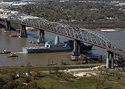
The Huey P. Long Bridge in Jefferson Parish, Louisiana
, is a cantilevered steel through truss bridge that carries a two-track railroad line over the Mississippi River
at mile 106.1 with two lanes of US 90 on each side of the central tracks.
Opened in December 1935 to replace the Walnut Street Ferry, the bridge was named for an extremely popular and notorious governor, Huey P. Long, who had just been assassinated
on September 8 of that year. The bridge was the first Mississippi River span built in Louisiana and the 29th along the length of the river. It is a few miles upriver from the city of New Orleans. The East Bank entrance is at Elmwood, Louisiana
and the West Bank at Bridge City
. It was designed by Ralph Modjeski
.
 The widest clean span is 790 feet (240.8 m) long and sits 135 feet (41.1 m) above the water. There are three navigation
channels below the bridge, the widest being 750 feet (228.6 m). The distinctive rail structure is 22996 feet (7,009.2 m) long and extends as a rail viaduct well into the city. It has sometimes been described as the longest rail bridge in the US, but the nearby Norfolk Southern Lake Pontchartrain Bridge
, at 5.8 miles, is considerably longer. The highway structure is 8076 feet (2,461.6 m) long with extremely steep grades on both sides. Each roadway deck is a precarious 18 feet (5.5 m) wide, with two nine-foot lanes, but because of the railroad component, is unusually flat for a bridge of this height. Normally, bridges this high have a hump to accommodate the height but this bridge is flat to accommodate rail traffic. http://www.johnweeks.com/lower_mississippi/pages/lmiss16.html
The bridge is a favorite railfan
location. It is owned by the New Orleans Public Belt Railroad
, which is owned by the City of New Orleans and managed by the Public Belt Railroad Commission. The bridge is hated by many drivers in the New Orleans area due to the narrow 9-foot (2.7 m) wide lanes without shoulders. Also, as the East Bank approach meets the superstructure of the bridge, the two vehicular roadways "jog" or shift inwards towards the bridge centerline about 1½ feet (0.45 m) since the through-truss portion of the superstructure is 3 foot (0.9144 m) wider than the deck truss portion of the east approach.
The foundation of the bridge is also unique. The land in and around New Orleans was formed by silt deposits brought down the Mississippi River. The clay topsoil (notorious for its role in the Hurricane Katrina
levee
failures) is compressible and unsuitable for foundation loads. However, bedrock is around 1000 feet (304.8 m) below the surface, making it too deep for normal bridge foundation construction. So, the main piers are seated on a layer of fine sand 160 to 170 feet (51.8 m) below Mean Gulf Level and rely on their massive weight and girth to hold them in place.
The bridge dates from an era when the construction of large works presented significant engineering challenges and the needs of rail and auto travel were more matched than they are today. Large bridges mixing rail tracks and highways were common, as typified by the
MacArthur Bridge
and McKinley Bridge
in St. Louis, Missouri
and the Harahan Bridge
in Memphis, Tennessee
. A second Huey P. Long Bridge
, which is very similar in design was built further upstream in 1940 in Baton Rouge, Louisiana
and was pretty much the last of its kind. While both of the Long bridges still carry both types of traffic, most of the others have been converted either to entirely rail use (Harahan in 1949, MacArthur in 1981) or entirely auto use (McKinley from 1978 to 2001, with pedestrian use added when it reopened in September 2007), and new large bridges are always devoted exclusively to meeting increasing vehicular traffic needs. Current rail demands are well met by existing bridges that are a testament to the care and craftsmanship of early 20th century bridge builders.
Work on the design of the bridge began in earnest in 1925 by the engineering firm of Modjeski and Masters
. Some pilings were actually driven that year to prevent expiration of congressional authority and provide further information for the design. As the magnitude of the project became apparent and projected costs ballooned, financing difficulties compounded by the Great Depression delayed the project. Finally, on November 5, 1932, the bonds of the Public Belt Railroad Commission were guaranteed by a complex agreement between the Southern Pacific Railroad, the City of New Orleans and the State of Louisiana. Main construction contracts were signed on December 30, 1932 and work formally started the following day. Construction of the bridge proceeded smoothly over a three-year period with only minor interruptions due to high water and a one-month strike in September 1933.
The $1.2 billion widening project started in April 2006 and is the first change to the structure since it opened in 1935. The project will expand the structure from two 9-foot lanes to three 11-foot lanes with a 2-foot inside shoulder and an 8-foot outside shoulder. It will also include new signalized intersections to replace the traffic circle at Jefferson Highway and Bridge City Avenue in Jefferson Parish, LA.
PROJECT DESCRIPTION
This seven year long four-phase project is slated to be completed in 2013. The timeline of the project continues to be on track as two of the four phases have been completed.
Phase I: Main Support Widening (Piers)
In this phase, completed in May 2009, four river piers and one land pier were widened to support the additional lanes. Reinforcing framework and concrete filled the void sections of the piers to strengthen them. In addition, w-shaped metal bridge struts were anchored to the upper part of each pier to support the additional new trusses and the existing truss.
Phase II: Railroad Modifications
In October 2006, work to relocate five selected railroad supports was done to facilitate the construction of the new approaches. This phase was completed in June 2008.
Phase III: Main Bridge Widening (Truss)
Estimated to be completed in 2012, this phase will widen the existing truss on either side to accommodate new travel lanes and shoulders.
The bridge, which is composed of four spans, will be erected one span at a time. In November 2009, construction of the West Bank Anchor Span began by using the stick-built method, meaning each element of the span will be individually placed. In order to minimize the use of falsework and river closures in the navigation or auxiliary channels the three remaining spans will be done through the span-by-span method. This method will involve large barges transporting a pre-assembled span section, positioning it under the bridge, and lifting it into position using strand jacks. Temporary stability frames made up of floorbeams and towers will be used to support the span section during the lifting process.
The construction progress of this phase can be viewed by accessing two of six web cameras installed — HPL Bridge Construction Web Cameras.
Phase IV: New Approaches Construction
During this phase of the project, the two existing 9-foot lanes will be widened to three 11-foot lane in each direction with 8-foot shoulders and 2-foot inside shoulders. The traffic circles at each end of the bridge will be replaced with signalized intersections. Also, new roadway and elevated structures will be constructed.
Four cameras were installed to view the approaches and ramps construction— two on the East Bank of Jefferson Parish and two on the West Bank of Jefferson Parish.
For additional information about the Huey P. Long Bridge Widening Project, visit the widening project web site.
Jefferson Parish, Louisiana
Jefferson Parish is a parish in Louisiana, United States that includes most of the suburbs of New Orleans. The seat of parish government is Gretna....
, is a cantilevered steel through truss bridge that carries a two-track railroad line over the Mississippi River
Mississippi River
The Mississippi River is the largest river system in North America. Flowing entirely in the United States, this river rises in western Minnesota and meanders slowly southwards for to the Mississippi River Delta at the Gulf of Mexico. With its many tributaries, the Mississippi's watershed drains...
at mile 106.1 with two lanes of US 90 on each side of the central tracks.
Opened in December 1935 to replace the Walnut Street Ferry, the bridge was named for an extremely popular and notorious governor, Huey P. Long, who had just been assassinated
Assassination
To carry out an assassination is "to murder by a sudden and/or secret attack, often for political reasons." Alternatively, assassination may be defined as "the act of deliberately killing someone, especially a public figure, usually for hire or for political reasons."An assassination may be...
on September 8 of that year. The bridge was the first Mississippi River span built in Louisiana and the 29th along the length of the river. It is a few miles upriver from the city of New Orleans. The East Bank entrance is at Elmwood, Louisiana
Elmwood, Louisiana
Elmwood is a census-designated place in Jefferson Parish, Louisiana, United States, within the New Orleans–Metairie–Kenner Metropolitan Statistical Area. The population was 4,270 at the 2000 census. Elmwood was part of neighboring Jefferson's census area from 1960 to 1990...
and the West Bank at Bridge City
Bridge City, Louisiana
Bridge City is an unincorporated community in Jefferson Parish, Louisiana, United States. It was established in the 1930s during the construction of the Huey P. Long Bridge over the Mississippi River. The town is located on the West Bank of the river. It is part of the New...
. It was designed by Ralph Modjeski
Ralph Modjeski
Ralph Modjeski was a Polish-born American civil engineer who achieved prominence as a pre-eminent bridge designer in the United States.-Life:...
.
Structure
channels below the bridge, the widest being 750 feet (228.6 m). The distinctive rail structure is 22996 feet (7,009.2 m) long and extends as a rail viaduct well into the city. It has sometimes been described as the longest rail bridge in the US, but the nearby Norfolk Southern Lake Pontchartrain Bridge
Norfolk Southern Lake Pontchartrain bridge
The Norfolk Southern Lake Pontchartrain Bridge is a bridge that carries a single-track of Norfolk Southern rail line between Slidell and New Orleans, Louisiana. At 5.8 miles long, it is the longest railroad bridge in the United States and likely the longest rail bridge over water on Earth. The...
, at 5.8 miles, is considerably longer. The highway structure is 8076 feet (2,461.6 m) long with extremely steep grades on both sides. Each roadway deck is a precarious 18 feet (5.5 m) wide, with two nine-foot lanes, but because of the railroad component, is unusually flat for a bridge of this height. Normally, bridges this high have a hump to accommodate the height but this bridge is flat to accommodate rail traffic. http://www.johnweeks.com/lower_mississippi/pages/lmiss16.html
The bridge is a favorite railfan
Railfan
A railfan or rail buff , railway enthusiast or railway buff , or trainspotter , is a person interested in a recreational capacity in rail transport...
location. It is owned by the New Orleans Public Belt Railroad
New Orleans Public Belt Railroad
The New Orleans Public Belt Railroad is a non-profit terminal switching railroad, owned by the City of New Orleans. It connects with six Class I railroads serving the city, and provides switching and haulage service....
, which is owned by the City of New Orleans and managed by the Public Belt Railroad Commission. The bridge is hated by many drivers in the New Orleans area due to the narrow 9-foot (2.7 m) wide lanes without shoulders. Also, as the East Bank approach meets the superstructure of the bridge, the two vehicular roadways "jog" or shift inwards towards the bridge centerline about 1½ feet (0.45 m) since the through-truss portion of the superstructure is 3 foot (0.9144 m) wider than the deck truss portion of the east approach.
The foundation of the bridge is also unique. The land in and around New Orleans was formed by silt deposits brought down the Mississippi River. The clay topsoil (notorious for its role in the Hurricane Katrina
Hurricane Katrina
Hurricane Katrina of the 2005 Atlantic hurricane season was a powerful Atlantic hurricane. It is the costliest natural disaster, as well as one of the five deadliest hurricanes, in the history of the United States. Among recorded Atlantic hurricanes, it was the sixth strongest overall...
levee
Levee
A levee, levée, dike , embankment, floodbank or stopbank is an elongated naturally occurring ridge or artificially constructed fill or wall, which regulates water levels...
failures) is compressible and unsuitable for foundation loads. However, bedrock is around 1000 feet (304.8 m) below the surface, making it too deep for normal bridge foundation construction. So, the main piers are seated on a layer of fine sand 160 to 170 feet (51.8 m) below Mean Gulf Level and rely on their massive weight and girth to hold them in place.
The bridge dates from an era when the construction of large works presented significant engineering challenges and the needs of rail and auto travel were more matched than they are today. Large bridges mixing rail tracks and highways were common, as typified by the
MacArthur Bridge
MacArthur Bridge (St. Louis)
The MacArthur Bridge over the Mississippi River between St. Louis, Missouri and East St. Louis, Illinois is a 647 foot long truss bridge. Construction on the bridge was begun in 1909 by the city of St. Louis to break the Terminal Railroad Association of St. Louis's monopoly on the area's railroad...
and McKinley Bridge
McKinley Bridge
The McKinley Bridge is a steel truss bridge across the Mississippi River. It connects northern portions of the city of St. Louis, Missouri with Venice, Illinois. It opened in 1910 and was taken out of service on October 30, 2001. The bridge was reopened for pedestrian and bicyclists on November 17,...
in St. Louis, Missouri
St. Louis, Missouri
St. Louis is an independent city on the eastern border of Missouri, United States. With a population of 319,294, it was the 58th-largest U.S. city at the 2010 U.S. Census. The Greater St...
and the Harahan Bridge
Harahan Bridge
The Harahan Bridge is a cantilevered through truss bridge carrying two rail lines across the Mississippi River between West Memphis, Arkansas and Memphis, Tennessee. The consulting engineer in charge was Ralph Modjeski. The bridge also carried motor vehicles from 1917–1949, when the Memphis &...
in Memphis, Tennessee
Memphis, Tennessee
Memphis is a city in the southwestern corner of the U.S. state of Tennessee, and the county seat of Shelby County. The city is located on the 4th Chickasaw Bluff, south of the confluence of the Wolf and Mississippi rivers....
. A second Huey P. Long Bridge
Huey P. Long Bridge (Baton Rouge)
The Huey P. Long Bridge is a truss cantilever bridge over the Mississippi River carrying US 190 and one rail line between East Baton Rouge Parish, Louisiana and West Baton Rouge Parish, Louisiana....
, which is very similar in design was built further upstream in 1940 in Baton Rouge, Louisiana
Baton Rouge, Louisiana
Baton Rouge is the capital of the U.S. state of Louisiana. It is located in East Baton Rouge Parish and is the second-largest city in the state.Baton Rouge is a major industrial, petrochemical, medical, and research center of the American South...
and was pretty much the last of its kind. While both of the Long bridges still carry both types of traffic, most of the others have been converted either to entirely rail use (Harahan in 1949, MacArthur in 1981) or entirely auto use (McKinley from 1978 to 2001, with pedestrian use added when it reopened in September 2007), and new large bridges are always devoted exclusively to meeting increasing vehicular traffic needs. Current rail demands are well met by existing bridges that are a testament to the care and craftsmanship of early 20th century bridge builders.
History
The history of the Huey P. Long bridge is almost as complex as the bridge structure itself. As early as 1892 the Southern Pacific Railway proposed a high level bridge, but a depression that year prevented further work on a project that would have been an overwhelming challenge for the engineers of the time due to soil conditions and extremely high clearances needed to clear river navigation. With the development of the Public Belt Railroad, interest in a river rail crossing grew and lead to passage of a constitutional amendment in 1916 granting the city exclusive power to build and operate a crossing. Three general ideas emerged from the planning process: a low-level drawbridge, a tunnel and a high-level bridge. The tunnel idea died first because it would have provided limited capacity and the War Department (after years of wrangling) ultimately rejected the idea of a drawbridge as too problematic for such a significant concentration of vital transportation infrastructure.Work on the design of the bridge began in earnest in 1925 by the engineering firm of Modjeski and Masters
Ralph Modjeski
Ralph Modjeski was a Polish-born American civil engineer who achieved prominence as a pre-eminent bridge designer in the United States.-Life:...
. Some pilings were actually driven that year to prevent expiration of congressional authority and provide further information for the design. As the magnitude of the project became apparent and projected costs ballooned, financing difficulties compounded by the Great Depression delayed the project. Finally, on November 5, 1932, the bonds of the Public Belt Railroad Commission were guaranteed by a complex agreement between the Southern Pacific Railroad, the City of New Orleans and the State of Louisiana. Main construction contracts were signed on December 30, 1932 and work formally started the following day. Construction of the bridge proceeded smoothly over a three-year period with only minor interruptions due to high water and a one-month strike in September 1933.
Expansion
The Huey P. Long Bridge Widening Project is a TIMED (Transportation Infrastructure Model for Economic Development) Program project. The TIMED Program was created by Act 16 of the 1989 Louisiana Legislature, was voted for by the people and is the single largest transportation program in state history. The Program is designed to enhance economic development in Louisiana through an investment in transportation projects.The $1.2 billion widening project started in April 2006 and is the first change to the structure since it opened in 1935. The project will expand the structure from two 9-foot lanes to three 11-foot lanes with a 2-foot inside shoulder and an 8-foot outside shoulder. It will also include new signalized intersections to replace the traffic circle at Jefferson Highway and Bridge City Avenue in Jefferson Parish, LA.
PROJECT DESCRIPTION
This seven year long four-phase project is slated to be completed in 2013. The timeline of the project continues to be on track as two of the four phases have been completed.
Phase I: Main Support Widening (Piers)
In this phase, completed in May 2009, four river piers and one land pier were widened to support the additional lanes. Reinforcing framework and concrete filled the void sections of the piers to strengthen them. In addition, w-shaped metal bridge struts were anchored to the upper part of each pier to support the additional new trusses and the existing truss.
Phase II: Railroad Modifications
In October 2006, work to relocate five selected railroad supports was done to facilitate the construction of the new approaches. This phase was completed in June 2008.
Phase III: Main Bridge Widening (Truss)
Estimated to be completed in 2012, this phase will widen the existing truss on either side to accommodate new travel lanes and shoulders.
The bridge, which is composed of four spans, will be erected one span at a time. In November 2009, construction of the West Bank Anchor Span began by using the stick-built method, meaning each element of the span will be individually placed. In order to minimize the use of falsework and river closures in the navigation or auxiliary channels the three remaining spans will be done through the span-by-span method. This method will involve large barges transporting a pre-assembled span section, positioning it under the bridge, and lifting it into position using strand jacks. Temporary stability frames made up of floorbeams and towers will be used to support the span section during the lifting process.
The construction progress of this phase can be viewed by accessing two of six web cameras installed — HPL Bridge Construction Web Cameras.
Phase IV: New Approaches Construction
During this phase of the project, the two existing 9-foot lanes will be widened to three 11-foot lane in each direction with 8-foot shoulders and 2-foot inside shoulders. The traffic circles at each end of the bridge will be replaced with signalized intersections. Also, new roadway and elevated structures will be constructed.
Four cameras were installed to view the approaches and ramps construction— two on the East Bank of Jefferson Parish and two on the West Bank of Jefferson Parish.
For additional information about the Huey P. Long Bridge Widening Project, visit the widening project web site.