
West Florida
Encyclopedia
West Florida was a region on the north shore of the Gulf of Mexico
, which underwent several boundary and sovereignty changes during its history. West Florida was first established in 1763 by the British
government; as its name suggests it largely consisted of the western portion of the region called Florida
by Spain, with East Florida
comprising the eastern part. It included most of what is now the Florida Panhandle
, plus parts of the modern U.S. states of Louisiana
, Mississippi
, and Alabama
.
Britain formed West and East Florida out of land taken from France
and Spain
after the French and Indian War
. As the newly acquired territory was too large to govern from one administrative center, the British divided it into two new colonies separated by the Apalachicola River
. West Florida's government was based in Pensacola
, and the colony included the part of formerly Spanish Florida
west of the Apalachicola, plus the parts of French Louisiana
taken by the British. It thus comprised all territory between the Mississippi
and Apalachicola Rivers, with a northern boundary that shifted several times over the subsequent years.
Both West and East Florida remained loyal to the British crown during the American Revolution
, and served as havens for Tories
fleeing from the Thirteen Colonies
. Spain invaded West Florida and captured Pensacola in 1781, and after the war Britain ceded both Floridas to Spain. However, the lack of defined boundaries led to a series of border disputes between Spain and the fledgling United States known as the West Florida Controversy
. Disagreements with the Spanish government led American and English settlers between the Mississippi and Perdido River
s to declare that area the independent Republic of West Florida in 1810. This was soon annexed by the United States, which claimed the region as part of the Louisiana Purchase
of 1803. In 1819 the United States negotiated the purchase of the remainder of West Florida and all of East Florida in the Adams–Onís Treaty, and both were merged into the Florida Territory
.
, which included most of what is now the southeastern United States. Spain made several attempts to conquer and colonize the area, notably including Tristán de Luna
's short-lived settlement in 1559, but permanent settlement did not occur until the 17th century, with the establishments of missions
to the Apalachee
. In 1698 the settlement of Pensacola
was established in order to check French
expansion into the area.
Beginning in the late 17th century the French established settlements in the region as part of Louisiana
, notably including Mobile
(1702) and Fort Toulouse
(1717) in present-day Alabama
. After years of contention the Perdido River
(the modern border between Florida and Alabama) was agreed upon as the boundary between French Louisiana and Spanish Florida.
In the treaty negotiations concluding the French and Indian War
(Seven Years' War
), France ceded to Britain the part of Louisiana east of the Mississippi River
, notably excluding the Île d'Orléans
, which includes New Orleans, to Britain. A separate treaty
transferred the rest of Louisiana to Spain. Spain ceded Florida to Britain in exchange for Cuba
, which the British had captured during the war. As a result of these exchanges the British controlled nearly all of the coast of the Gulf of Mexico east of the Mississippi. Most of the Spanish population left Florida, and its colonial government records were relocated to Havana, Cuba.
, separated by the Apalachicola River
. East Florida consisted of most of the formerly Spanish Florida, and retained the old Spanish capital of St. Augustine
. West Florida comprised the land between the Mississippi and Apalachicola Rivers, with Pensacola designated as its capital. The northern boundary was arbitrarily set at the 31st parallel north
.
Many English American
s and Scotch-Irish Americans moved to the territory at this time. The Governor of West Florida in November 1763 was George Johnstone; his lieutenant governor, Montfort Browne
, was a major landowner in the province who heavily promoted its development. The British established an assembly
, introducing democracy
to the territory.
In 1764, the British moved the northern boundary to the 32° 22′ north latitude, extending from the Yazoo
to the Chattahoochee River
, which included the Natchez District
and the Tombigbee District
. The appended area included approximately the lower half of the present states of Mississippi
and Alabama
. Many new settlers arrived in the wake of the British garrison, swelling the population. In 1774 the First Continental Congress
sent letters inviting West Florida to send delegates, but this proposal was declined as the inhabitants were overwhelmingly Loyalist
. During the American War of Independence the Governor of West Florida was Peter Chester. The commander of British forces during the war was John Campbell. The colony was attacked in 1778 by the Willing Expedition and then overrun in 1779-81 by Spanish forces under Bernardo de Gálvez, culminating in the Siege of Pensacola.
, which ended the war, the British agreed to a boundary between the United States and West Florida at 31° north latitude between the Mississippi and Apalachicola Rivers. Britain also ceded both Florida provinces back to Spain, which continued to maintain them as separate colonies. However, the treaty did not specify the boundaries, sparking the West Florida Controversy
. Spain claimed the expanded 1764 boundary, while the United States claimed that the boundary was at the 31st parallel. Negotiations
in 1785-1786 between John Jay
and Don Diego de Gardoqui
failed to reach a satisfactory conclusion. The border was finally resolved in 1795 by the Treaty of San Lorenzo, in which Spain recognized the 31st parallel as the boundary.
In the secret Treaty of San Ildefonso
of 1800, Spain returned Louisiana to France; however, the boundaries were not specified. After France sold the Louisiana Purchase
to the United States in 1803, another boundary dispute erupted. The United States laid claim to the territory from the Perdido River
to the Mississippi River, which the Americans believed had been a part of the old province of Louisiana when the French had ceded it in 1763. The Spanish insisted that they had administered that portion as the province of West Florida and that it was not part of the territory returned to France in 1800.
 The United States and Spain held long, inconclusive negotiations on the status of West Florida. In the meantime, American settlers established a foothold in the area and resisted Spanish control. British settlers, who had remained, also resented Spanish rule, leading to a rebellion
in 1810 and the establishment for exactly 90 days of the Republic of West Florida.
On September 23, 1810, after meetings beginning in June, rebels overcame the Spanish garrison at Baton Rouge
and unfurled the flag of the new republic: a single white star on a blue field. This flag was made by Melissa Johnson, wife of Major Isaac Johnson, the commander of the West Florida Dragoons. It would later become known as the "Bonnie Blue Flag
".
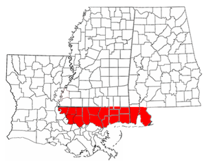
The boundaries of the Republic of West Florida included all territory south of the 31st parallel, west of the Perdido River
, and east of the Mississippi River
, but north of Lake Pontchartrain
. The southern boundary was the Gulf of Mexico
. It included Baldwin
and Mobile
counties in what is now Alabama; the Mississippi counties of Hancock
, Pearl River
, Harrison
, Stone
, Jackson
, and George
, as well as the southernmost portions of Lamar
, Forrest
, Perry
, and Wayne
counties; and the Louisiana parishes of East Baton Rouge, East and West Feliciana, Livingston, St. Helena, Tangipahoa, St. Tammany and Washington. Despite its name, none of present-day Florida lay within its borders. The capital of the Republic of West Florida was St. Francisville
in present-day Louisiana, on a bluff along the Mississippi River.
The Constitution of West Florida was based largely on the United States Constitution, and divided the government into three branches: executive, judicial, and legislative. The legislature consisted of a Senate and House of Representatives. The Governor was chosen by the legislature. According to the constitution, the official name of the nation was the "State of Florida". The first and only governor was Fulwar Skipwith
, a former American diplomat who had helped negotiate the Louisiana Purchase
. In his inaugural address, Skipwith mentioned the possibility of annexation to the United States:
Reuben Kemper
led a small force in an attempt to capture Mobile
from the Spanish, but the expedition ended in failure. The marching song of the West Floridian army included the lyrics:
 On October 27, 1810, the ostensible Republic of West Florida was annexed by proclamation
of U.S. President James Madison
, who claimed the region as part of the Louisiana Purchase. At first, Skipwith and the West Florida government were opposed to the proclamation, preferring to negotiate terms to join the Union. However, William C. C. Claiborne, who was sent to take possession of the territory, refused to recognize the legitimacy of the West Florida government. Skipwith proclaimed that he was ready to "die in defense of the Lone Star flag." However, Skipwith and the legislature eventually backed down and agreed to accept Madison's proclamation.
The United States took possession of St. Francisville on December 6, 1810, and of Baton Rouge
on December 10, 1810. These portions were incorporated into the newly formed Territory of Orleans. The U.S. annexed the Mobile District
of West Florida to the Mississippi Territory
in 1812.
In 1819 Spain and the United States agreed to the Adams-Onís Treaty
. In this treaty Spain ceded both West and East Florida to the United States in exchange for compensation and the renunciation of American claims to Texas
. The treaty took effect in 1821 and the U.S. military took over governance of both Floridas, establishing the current boundaries. The United States organized the Florida Territory
on March 30, 1822; it was admitted to the Union as a state
in 1845.
West Florida had an effect on chosing the location of Florida's current capital. At first, the Florida territorial Legislative Council determined to rotate between the historical capitals of Pensacola and St. Augustine. The first legislative session was held at Pensacola on July 22, 1822; this required delegates from St. Augustine to travel 59 days by sea to attend. To get to the second session in St. Augustine, Pensacola members traveled 28 days over land. During this session, the council decided future meetings should be held at a half-way point to reduce the distance; eventually Tallahassee, site of an Apalachee
settlement in the early 18th century, was selected as a half-way point between the former capitals of East and West Florida.
The portions of West Florida now located in Louisiana are known as the Florida Parishes
. The Republic of West Florida Historical Museum is located in Jackson
. In 1993, the Louisiana State Legislature
renamed Interstate 12
, the full length of which is contained in the Florida Parishes, as the "Republic of West Florida Parkway." In 2002, Leila Lee Roberts, a great-granddaughter of Fulwar Skipwith, donated the original copy of the constitution of the West Florida Republic and supporting papers to the Louisiana
State Archives.
Governors under Spanish rule:
Gulf of Mexico
The Gulf of Mexico is a partially landlocked ocean basin largely surrounded by the North American continent and the island of Cuba. It is bounded on the northeast, north and northwest by the Gulf Coast of the United States, on the southwest and south by Mexico, and on the southeast by Cuba. In...
, which underwent several boundary and sovereignty changes during its history. West Florida was first established in 1763 by the British
Kingdom of Great Britain
The former Kingdom of Great Britain, sometimes described as the 'United Kingdom of Great Britain', That the Two Kingdoms of Scotland and England, shall upon the 1st May next ensuing the date hereof, and forever after, be United into One Kingdom by the Name of GREAT BRITAIN. was a sovereign...
government; as its name suggests it largely consisted of the western portion of the region called Florida
Spanish Florida
Spanish Florida refers to the Spanish territory of Florida, which formed part of the Captaincy General of Cuba, the Viceroyalty of New Spain, and the Spanish Empire. Originally extending over what is now the southeastern United States, but with no defined boundaries, la Florida was a component of...
by Spain, with East Florida
East Florida
East Florida was a colony of Great Britain from 1763–1783 and of Spain from 1783–1822. East Florida was established by the British colonial government in 1763; as its name implies it consisted of the eastern part of the region of Florida, with West Florida comprising the western parts. Its capital...
comprising the eastern part. It included most of what is now the Florida Panhandle
Florida Panhandle
The Florida Panhandle, an informal, unofficial term for the northwestern part of Florida, is a strip of land roughly 200 miles long and 50 to 100 miles wide , lying between Alabama on the north and the west, Georgia also on the north, and the Gulf of Mexico to the south. Its eastern boundary is...
, plus parts of the modern U.S. states of Louisiana
Louisiana
Louisiana is a state located in the southern region of the United States of America. Its capital is Baton Rouge and largest city is New Orleans. Louisiana is the only state in the U.S. with political subdivisions termed parishes, which are local governments equivalent to counties...
, Mississippi
Mississippi
Mississippi is a U.S. state located in the Southern United States. Jackson is the state capital and largest city. The name of the state derives from the Mississippi River, which flows along its western boundary, whose name comes from the Ojibwe word misi-ziibi...
, and Alabama
Alabama
Alabama is a state located in the southeastern region of the United States. It is bordered by Tennessee to the north, Georgia to the east, Florida and the Gulf of Mexico to the south, and Mississippi to the west. Alabama ranks 30th in total land area and ranks second in the size of its inland...
.
Britain formed West and East Florida out of land taken from France
France
The French Republic , The French Republic , The French Republic , (commonly known as France , is a unitary semi-presidential republic in Western Europe with several overseas territories and islands located on other continents and in the Indian, Pacific, and Atlantic oceans. Metropolitan France...
and Spain
Spain
Spain , officially the Kingdom of Spain languages]] under the European Charter for Regional or Minority Languages. In each of these, Spain's official name is as follows:;;;;;;), is a country and member state of the European Union located in southwestern Europe on the Iberian Peninsula...
after the French and Indian War
French and Indian War
The French and Indian War is the common American name for the war between Great Britain and France in North America from 1754 to 1763. In 1756, the war erupted into the world-wide conflict known as the Seven Years' War and thus came to be regarded as the North American theater of that war...
. As the newly acquired territory was too large to govern from one administrative center, the British divided it into two new colonies separated by the Apalachicola River
Apalachicola River
The Apalachicola River is a river, approximately 112 mi long in the State of Florida. This river's large watershed, known as the ACF River Basin for short, drains an area of approximately into the Gulf of Mexico. The distance to its farthest headstream in northeast Georgia is approximately 500...
. West Florida's government was based in Pensacola
Pensacola, Florida
Pensacola is the westernmost city in the Florida Panhandle and the county seat of Escambia County, Florida, United States of America. As of the 2000 census, the city had a total population of 56,255 and as of 2009, the estimated population was 53,752...
, and the colony included the part of formerly Spanish Florida
Spanish Florida
Spanish Florida refers to the Spanish territory of Florida, which formed part of the Captaincy General of Cuba, the Viceroyalty of New Spain, and the Spanish Empire. Originally extending over what is now the southeastern United States, but with no defined boundaries, la Florida was a component of...
west of the Apalachicola, plus the parts of French Louisiana
Louisiana (New France)
Louisiana or French Louisiana was an administrative district of New France. Under French control from 1682–1763 and 1800–03, the area was named in honor of Louis XIV, by French explorer René-Robert Cavelier, Sieur de la Salle...
taken by the British. It thus comprised all territory between the Mississippi
Mississippi River
The Mississippi River is the largest river system in North America. Flowing entirely in the United States, this river rises in western Minnesota and meanders slowly southwards for to the Mississippi River Delta at the Gulf of Mexico. With its many tributaries, the Mississippi's watershed drains...
and Apalachicola Rivers, with a northern boundary that shifted several times over the subsequent years.
Both West and East Florida remained loyal to the British crown during the American Revolution
American Revolution
The American Revolution was the political upheaval during the last half of the 18th century in which thirteen colonies in North America joined together to break free from the British Empire, combining to become the United States of America...
, and served as havens for Tories
Loyalist (American Revolution)
Loyalists were American colonists who remained loyal to the Kingdom of Great Britain during the American Revolutionary War. At the time they were often called Tories, Royalists, or King's Men. They were opposed by the Patriots, those who supported the revolution...
fleeing from the Thirteen Colonies
Thirteen Colonies
The Thirteen Colonies were English and later British colonies established on the Atlantic coast of North America between 1607 and 1733. They declared their independence in the American Revolution and formed the United States of America...
. Spain invaded West Florida and captured Pensacola in 1781, and after the war Britain ceded both Floridas to Spain. However, the lack of defined boundaries led to a series of border disputes between Spain and the fledgling United States known as the West Florida Controversy
West Florida Controversy
The West Florida Controversy was a series of border disputes between Spain and the United States over the region known as West Florida. The controversy commenced immediately after Spain received the colonies of West and East Florida from the Kingdom of Great Britain following the American...
. Disagreements with the Spanish government led American and English settlers between the Mississippi and Perdido River
Perdido River
The Perdido River is a river in the U.S. states of Alabama and Florida. The river forms part of the boundary between the two states along nearly its entire length and drains into the Gulf of Mexico...
s to declare that area the independent Republic of West Florida in 1810. This was soon annexed by the United States, which claimed the region as part of the Louisiana Purchase
Louisiana Purchase
The Louisiana Purchase was the acquisition by the United States of America of of France's claim to the territory of Louisiana in 1803. The U.S...
of 1803. In 1819 the United States negotiated the purchase of the remainder of West Florida and all of East Florida in the Adams–Onís Treaty, and both were merged into the Florida Territory
Florida Territory
The Territory of Florida was an organized incorporated territory of the United States that existed from March 30, 1822, until March 3, 1845, when it was admitted to the Union as the State of Florida...
.
Background
The area known as West Florida was originally claimed by Spain as part of La FloridaSpanish Florida
Spanish Florida refers to the Spanish territory of Florida, which formed part of the Captaincy General of Cuba, the Viceroyalty of New Spain, and the Spanish Empire. Originally extending over what is now the southeastern United States, but with no defined boundaries, la Florida was a component of...
, which included most of what is now the southeastern United States. Spain made several attempts to conquer and colonize the area, notably including Tristán de Luna
Tristán de Luna y Arellano
Tristán de Luna y Arellano was a Spanish Conquistador of the 16th century. Born in Borobia, Spain, he came to New Spain in about 1530, and was sent on an expedition to conquer Florida in 1559...
's short-lived settlement in 1559, but permanent settlement did not occur until the 17th century, with the establishments of missions
Spanish missions in Florida
Beginning in the second half of the 16th century, the Kingdom of Spain established a number of missions throughout la Florida in order to convert the Indians to Christianity, to facilitate control of the area, and to prevent its colonization by other countries, in particular, England and France...
to the Apalachee
Apalachee
The Apalachee are a Native American people who historically lived in the Florida Panhandle, and now live primarily in the U.S. state of Louisiana. Their historical territory was known to the Spanish colonists as the Apalachee Province...
. In 1698 the settlement of Pensacola
Pensacola, Florida
Pensacola is the westernmost city in the Florida Panhandle and the county seat of Escambia County, Florida, United States of America. As of the 2000 census, the city had a total population of 56,255 and as of 2009, the estimated population was 53,752...
was established in order to check French
France
The French Republic , The French Republic , The French Republic , (commonly known as France , is a unitary semi-presidential republic in Western Europe with several overseas territories and islands located on other continents and in the Indian, Pacific, and Atlantic oceans. Metropolitan France...
expansion into the area.
Beginning in the late 17th century the French established settlements in the region as part of Louisiana
Louisiana (New France)
Louisiana or French Louisiana was an administrative district of New France. Under French control from 1682–1763 and 1800–03, the area was named in honor of Louis XIV, by French explorer René-Robert Cavelier, Sieur de la Salle...
, notably including Mobile
Mobile, Alabama
Mobile is the third most populous city in the Southern US state of Alabama and is the county seat of Mobile County. It is located on the Mobile River and the central Gulf Coast of the United States. The population within the city limits was 195,111 during the 2010 census. It is the largest...
(1702) and Fort Toulouse
Fort Toulouse
Fort Toulouse is a historic fort near the city of Wetumpka, Alabama, United States, that is now maintained by the Alabama Historical Commission. The French founded the fort in 1717, naming it for Louis-Alexandre de Bourbon, comte de Toulouse...
(1717) in present-day Alabama
Alabama
Alabama is a state located in the southeastern region of the United States. It is bordered by Tennessee to the north, Georgia to the east, Florida and the Gulf of Mexico to the south, and Mississippi to the west. Alabama ranks 30th in total land area and ranks second in the size of its inland...
. After years of contention the Perdido River
Perdido River
The Perdido River is a river in the U.S. states of Alabama and Florida. The river forms part of the boundary between the two states along nearly its entire length and drains into the Gulf of Mexico...
(the modern border between Florida and Alabama) was agreed upon as the boundary between French Louisiana and Spanish Florida.
In the treaty negotiations concluding the French and Indian War
French and Indian War
The French and Indian War is the common American name for the war between Great Britain and France in North America from 1754 to 1763. In 1756, the war erupted into the world-wide conflict known as the Seven Years' War and thus came to be regarded as the North American theater of that war...
(Seven Years' War
Seven Years' War
The Seven Years' War was a global military war between 1756 and 1763, involving most of the great powers of the time and affecting Europe, North America, Central America, the West African coast, India, and the Philippines...
), France ceded to Britain the part of Louisiana east of the Mississippi River
Mississippi River
The Mississippi River is the largest river system in North America. Flowing entirely in the United States, this river rises in western Minnesota and meanders slowly southwards for to the Mississippi River Delta at the Gulf of Mexico. With its many tributaries, the Mississippi's watershed drains...
, notably excluding the Île d'Orléans
Île d'Orléans, Louisiana
Île d'Orléans was the historic French name for the New Orleans area, in current Louisiana, United States.At the end of the French and Indian Wars in 1763, the French turned over nearly all their territory east of the Mississippi River to the British. The exception was New Orleans or more...
, which includes New Orleans, to Britain. A separate treaty
Treaty of Fontainebleau (1762)
The Treaty of Fontainebleau was a secret agreement in which France ceded Louisiana to Spain. The treaty followed the last battle in the French and Indian War, the Battle of Signal Hill in September 1762, which confirmed British control of Canada. However, the associated Seven Years War continued...
transferred the rest of Louisiana to Spain. Spain ceded Florida to Britain in exchange for Cuba
Cuba
The Republic of Cuba is an island nation in the Caribbean. The nation of Cuba consists of the main island of Cuba, the Isla de la Juventud, and several archipelagos. Havana is the largest city in Cuba and the country's capital. Santiago de Cuba is the second largest city...
, which the British had captured during the war. As a result of these exchanges the British controlled nearly all of the coast of the Gulf of Mexico east of the Mississippi. Most of the Spanish population left Florida, and its colonial government records were relocated to Havana, Cuba.
British era
Finding this new territory too large to govern as one unit, the British divided it into two new colonies, West Florida and East FloridaEast Florida
East Florida was a colony of Great Britain from 1763–1783 and of Spain from 1783–1822. East Florida was established by the British colonial government in 1763; as its name implies it consisted of the eastern part of the region of Florida, with West Florida comprising the western parts. Its capital...
, separated by the Apalachicola River
Apalachicola River
The Apalachicola River is a river, approximately 112 mi long in the State of Florida. This river's large watershed, known as the ACF River Basin for short, drains an area of approximately into the Gulf of Mexico. The distance to its farthest headstream in northeast Georgia is approximately 500...
. East Florida consisted of most of the formerly Spanish Florida, and retained the old Spanish capital of St. Augustine
St. Augustine, Florida
St. Augustine is a city in the northeast section of Florida and the county seat of St. Johns County, Florida, United States. Founded in 1565 by Spanish explorer and admiral Pedro Menéndez de Avilés, it is the oldest continuously occupied European-established city and port in the continental United...
. West Florida comprised the land between the Mississippi and Apalachicola Rivers, with Pensacola designated as its capital. The northern boundary was arbitrarily set at the 31st parallel north
31st parallel north
The 31st parallel north is a circle of latitude that is 31 degrees north of the Earth's equatorial plane. It crosses Africa, Asia, the Pacific Ocean, North America and the Atlantic Ocean.Part of the border between Iran and Iraq is defined by the parallel....
.
Many English American
English American
English Americans are citizens or residents of the United States whose ancestry originates wholly or partly in England....
s and Scotch-Irish Americans moved to the territory at this time. The Governor of West Florida in November 1763 was George Johnstone; his lieutenant governor, Montfort Browne
Montfort Browne
Montfort Browne was a British Army officer and Tory, and a major landowner and developer of British West Florida in the 1760s and 1770s. He commanded the Prince of Wales' American Regiment, a Loyalist regiment, in the American Revolutionary War...
, was a major landowner in the province who heavily promoted its development. The British established an assembly
Deliberative assembly
A deliberative assembly is an organization comprising members who use parliamentary procedure to make decisions. In a speech to the electorate at Bristol in 1774, Edmund Burke described the English Parliament as a "deliberative assembly," and the expression became the basic term for a body of...
, introducing democracy
Democracy
Democracy is generally defined as a form of government in which all adult citizens have an equal say in the decisions that affect their lives. Ideally, this includes equal participation in the proposal, development and passage of legislation into law...
to the territory.
In 1764, the British moved the northern boundary to the 32° 22′ north latitude, extending from the Yazoo
Yazoo River
The Yazoo River is a river in the U.S. state of Mississippi.The Yazoo River was named by French explorer La Salle in 1682 as "Rivière des Yazous" in reference to the Yazoo tribe living near the river's mouth. The exact meaning of the term is unclear...
to the Chattahoochee River
Chattahoochee River
The Chattahoochee River flows through or along the borders of the U.S. states of Georgia, Alabama, and Florida. It is a tributary of the Apalachicola River, a relatively short river formed by the confluence of the Chattahoochee and Flint Rivers and emptying into Apalachicola Bay in the Gulf of...
, which included the Natchez District
Natchez District
The Natchez District was one of two areas, the other being the Tombigbee District, that were the first to be colonized by British subjects from the Thirteen Colonies and elsewhere in what was West Florida and would later become the Mississippi Territory. The district was recognized to be the area...
and the Tombigbee District
Tombigbee District
The Tombigbee District, also known as the Tombigbee settlements, was one of two areas, the other being the Natchez District, that were the first to be colonized by British subjects from the Thirteen Colonies and elsewhere in what was West Florida and later became the Mississippi Territory...
. The appended area included approximately the lower half of the present states of Mississippi
Mississippi
Mississippi is a U.S. state located in the Southern United States. Jackson is the state capital and largest city. The name of the state derives from the Mississippi River, which flows along its western boundary, whose name comes from the Ojibwe word misi-ziibi...
and Alabama
Alabama
Alabama is a state located in the southeastern region of the United States. It is bordered by Tennessee to the north, Georgia to the east, Florida and the Gulf of Mexico to the south, and Mississippi to the west. Alabama ranks 30th in total land area and ranks second in the size of its inland...
. Many new settlers arrived in the wake of the British garrison, swelling the population. In 1774 the First Continental Congress
First Continental Congress
The First Continental Congress was a convention of delegates from twelve of the thirteen North American colonies that met on September 5, 1774, at Carpenters' Hall in Philadelphia, Pennsylvania, early in the American Revolution. It was called in response to the passage of the Coercive Acts by the...
sent letters inviting West Florida to send delegates, but this proposal was declined as the inhabitants were overwhelmingly Loyalist
Loyalist (American Revolution)
Loyalists were American colonists who remained loyal to the Kingdom of Great Britain during the American Revolutionary War. At the time they were often called Tories, Royalists, or King's Men. They were opposed by the Patriots, those who supported the revolution...
. During the American War of Independence the Governor of West Florida was Peter Chester. The commander of British forces during the war was John Campbell. The colony was attacked in 1778 by the Willing Expedition and then overrun in 1779-81 by Spanish forces under Bernardo de Gálvez, culminating in the Siege of Pensacola.
Spanish era
In the 1783 Treaty of ParisTreaty of Paris (1783)
The Treaty of Paris, signed on September 3, 1783, ended the American Revolutionary War between Great Britain on the one hand and the United States of America and its allies on the other. The other combatant nations, France, Spain and the Dutch Republic had separate agreements; for details of...
, which ended the war, the British agreed to a boundary between the United States and West Florida at 31° north latitude between the Mississippi and Apalachicola Rivers. Britain also ceded both Florida provinces back to Spain, which continued to maintain them as separate colonies. However, the treaty did not specify the boundaries, sparking the West Florida Controversy
West Florida Controversy
The West Florida Controversy was a series of border disputes between Spain and the United States over the region known as West Florida. The controversy commenced immediately after Spain received the colonies of West and East Florida from the Kingdom of Great Britain following the American...
. Spain claimed the expanded 1764 boundary, while the United States claimed that the boundary was at the 31st parallel. Negotiations
Jay-Gardoqui Treaty
The Jay–Gardoqui Treaty of 1789 between the United States and Spain guaranteed Spain's exclusive right to navigate the Mississippi River for 30 years. It also opened Spain's European and West Indian seaports to American shipping...
in 1785-1786 between John Jay
John Jay
John Jay was an American politician, statesman, revolutionary, diplomat, a Founding Father of the United States, and the first Chief Justice of the United States ....
and Don Diego de Gardoqui
Don Diego de Gardoqui
Don Diego María de Gardoqui y Arriquibar Gardoqui-Gardoki Translation: Basque - Fernery was a Spanish-born politician and diplomat.-Biography:Diego de Gardoqui, the fourth of eight children, was the financial intermediary between the...
failed to reach a satisfactory conclusion. The border was finally resolved in 1795 by the Treaty of San Lorenzo, in which Spain recognized the 31st parallel as the boundary.
In the secret Treaty of San Ildefonso
Third Treaty of San Ildefonso
The Third Treaty of San Ildefonso was a secretly negotiated treaty between France and Spain in which Spain returned the colonial territory of...
of 1800, Spain returned Louisiana to France; however, the boundaries were not specified. After France sold the Louisiana Purchase
Louisiana Purchase
The Louisiana Purchase was the acquisition by the United States of America of of France's claim to the territory of Louisiana in 1803. The U.S...
to the United States in 1803, another boundary dispute erupted. The United States laid claim to the territory from the Perdido River
Perdido River
The Perdido River is a river in the U.S. states of Alabama and Florida. The river forms part of the boundary between the two states along nearly its entire length and drains into the Gulf of Mexico...
to the Mississippi River, which the Americans believed had been a part of the old province of Louisiana when the French had ceded it in 1763. The Spanish insisted that they had administered that portion as the province of West Florida and that it was not part of the territory returned to France in 1800.
Republic of West Florida
Rebellion
Rebellion, uprising or insurrection, is a refusal of obedience or order. It may, therefore, be seen as encompassing a range of behaviors aimed at destroying or replacing an established authority such as a government or a head of state...
in 1810 and the establishment for exactly 90 days of the Republic of West Florida.
On September 23, 1810, after meetings beginning in June, rebels overcame the Spanish garrison at Baton Rouge
Baton Rouge, Louisiana
Baton Rouge is the capital of the U.S. state of Louisiana. It is located in East Baton Rouge Parish and is the second-largest city in the state.Baton Rouge is a major industrial, petrochemical, medical, and research center of the American South...
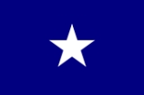
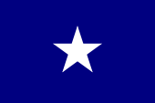
and unfurled the flag of the new republic: a single white star on a blue field. This flag was made by Melissa Johnson, wife of Major Isaac Johnson, the commander of the West Florida Dragoons. It would later become known as the "Bonnie Blue Flag
Bonnie Blue Flag
The Bonnie Blue Flag, a single white star on a blue field, was the flag of the short-lived Republic of West Florida. Decades later, during the Civil War, it became an unofficial banner of the Confederacy, inspiring the song "The Bonnie Blue Flag," which was often sung by Southern troops.The flag...
".
The boundaries of the Republic of West Florida included all territory south of the 31st parallel, west of the Perdido River
Perdido River
The Perdido River is a river in the U.S. states of Alabama and Florida. The river forms part of the boundary between the two states along nearly its entire length and drains into the Gulf of Mexico...
, and east of the Mississippi River
Mississippi River
The Mississippi River is the largest river system in North America. Flowing entirely in the United States, this river rises in western Minnesota and meanders slowly southwards for to the Mississippi River Delta at the Gulf of Mexico. With its many tributaries, the Mississippi's watershed drains...
, but north of Lake Pontchartrain
Lake Pontchartrain
Lake Pontchartrain is a brackish estuary located in southeastern Louisiana. It is the second-largest inland saltwater body of water in the United States, after the Great Salt Lake in Utah, and the largest lake in Louisiana. As an estuary, Pontchartrain is not a true lake.It covers an area of with...
. The southern boundary was the Gulf of Mexico
Gulf of Mexico
The Gulf of Mexico is a partially landlocked ocean basin largely surrounded by the North American continent and the island of Cuba. It is bounded on the northeast, north and northwest by the Gulf Coast of the United States, on the southwest and south by Mexico, and on the southeast by Cuba. In...
. It included Baldwin
Baldwin County, Alabama
-2010:Whereas according to the 2010 U.S. Census Bureau:*85.7% White*9.4% Black*0.7% Native American*0.7% Asian*0.0% Native Hawaiian or Pacific Islander*1.5% Two or more races*4.4% Hispanic or Latino -2000:...
and Mobile
Mobile County, Alabama
Mobile County[p] is a county of the U.S. state of Alabama. Its name is in honor of a tribe of Indians, the Maubila tribe . As of 2011, its population was 415,704. Its county seat is Mobile, Alabama...
counties in what is now Alabama; the Mississippi counties of Hancock
Hancock County, Mississippi
-Demographics:As of the census of 2000, there were 42,967 people, 16,897 households, and 11,827 families residing in the county. The population density was 90 people per square mile . There were 21,072 housing units at an average density of 44 per square mile...
, Pearl River
Pearl River County, Mississippi
-National protected areas:*Bogue Chitto National Wildlife Refuge *De Soto National Forest -Demographics:The census estimates of 2006 place the county population over 57,000 and place it among the 10 fastest growing counties in the U.S. As of the census of 2000, there were 48,621 people, 18,078...
, Harrison
Harrison County, Mississippi
-National protected areas:* De Soto National Forest * Gulf Islands National Seashore - Demographics :As of the census of 2000, there were 189,601 people, 71,538 households, and 48,574 families residing in the county. The population density was 326 people per square mile . There were 79,636 housing...
, Stone
Stone County, Mississippi
As of the census of 2000, there were 13,622 people, 4,747 households, and 3,626 families residing in the county. The population density was 31 people per square mile . There were 5,343 housing units at an average density of 12 per square mile...
, Jackson
Jackson County, Mississippi
There were 47,676 households out of which 37.00% had children under the age of 18 living with them, 55.70% were married couples living together, 14.50% had a female householder with no husband present, and 25.10% were non-families. 20.80% of all households were made up of individuals and 7.10% had...
, and George
George County, Mississippi
-Demographics:As of the census of 2000, there were 19,144 people, 6,742 households, and 5,305 families residing in the county. The population density was 40 people per square mile . There were 7,513 housing units at an average density of 16 per square mile...
, as well as the southernmost portions of Lamar
Lamar County, Mississippi
-Demographics:As of the census of 2000, there were 39,070 people, 14,396 households, and 10,725 families residing in the county. The population density was 79 people per square mile . There were 15,433 housing units at an average density of 31 per square mile...
, Forrest
Forrest County, Mississippi
The median income for a household in the county was $27,420, and the median income for a family was $35,791. Males had a median income of $28,742 versus $20,500 for females. The per capita income for the county was $15,160...
, Perry
Perry County, Mississippi
-Demographics:As of the census of 2000, there were 12,138 people, 4,420 households, and 3,332 families residing in the county. The population density was 19 people per square mile . There were 5,107 housing units at an average density of 8 per square mile...
, and Wayne
Wayne County, Mississippi
-Demographics:As of the census of 2000, there were 21,216 people, 7,857 households, and 5,853 families residing in the county. The population density was 26 people per square mile . There were 9,049 housing units at an average density of 11 per square mile...
counties; and the Louisiana parishes of East Baton Rouge, East and West Feliciana, Livingston, St. Helena, Tangipahoa, St. Tammany and Washington. Despite its name, none of present-day Florida lay within its borders. The capital of the Republic of West Florida was St. Francisville
St. Francisville, Louisiana
St. Francisville is a town in and the parish seat of West Feliciana Parish, Louisiana, United States. The population was 1,712 at the 2000 census. It is part of the Baton Rouge Metropolitan Statistical Area.-Geography:St...
in present-day Louisiana, on a bluff along the Mississippi River.
The Constitution of West Florida was based largely on the United States Constitution, and divided the government into three branches: executive, judicial, and legislative. The legislature consisted of a Senate and House of Representatives. The Governor was chosen by the legislature. According to the constitution, the official name of the nation was the "State of Florida". The first and only governor was Fulwar Skipwith
Fulwar Skipwith
Fulwar Skipwith was an American diplomat and politician, who served as a U.S. Consul in Martinique, and later as the U.S. Consul-General in France...
, a former American diplomat who had helped negotiate the Louisiana Purchase
Louisiana Purchase
The Louisiana Purchase was the acquisition by the United States of America of of France's claim to the territory of Louisiana in 1803. The U.S...
. In his inaugural address, Skipwith mentioned the possibility of annexation to the United States:
Reuben Kemper
Reuben Kemper
Reuben Kemper was an American pioneer and fillibuster.-Kemper and West Florida:Born in Fauquier County, Virginia, Kemper and his brothers Nathan and Samuel settled in Feliciana, near Baton Rouge, Spanish West Florida, shortly after 1800...
led a small force in an attempt to capture Mobile
Mobile, Alabama
Mobile is the third most populous city in the Southern US state of Alabama and is the county seat of Mobile County. It is located on the Mobile River and the central Gulf Coast of the United States. The population within the city limits was 195,111 during the 2010 census. It is the largest...
from the Spanish, but the expedition ended in failure. The marching song of the West Floridian army included the lyrics:
- West Floriday, that lovely nation,
- Free from king and tyranny,
- Thru’ the world shall be respected,
- For her true love of Liberty.
American annexation of the Republic
Proclamation
A proclamation is an official declaration.-England and Wales:In English law, a proclamation is a formal announcement , made under the great seal, of some matter which the King in Council or Queen in Council desires to make known to his or her subjects: e.g., the declaration of war, or state of...
of U.S. President James Madison
James Madison
James Madison, Jr. was an American statesman and political theorist. He was the fourth President of the United States and is hailed as the “Father of the Constitution” for being the primary author of the United States Constitution and at first an opponent of, and then a key author of the United...
, who claimed the region as part of the Louisiana Purchase. At first, Skipwith and the West Florida government were opposed to the proclamation, preferring to negotiate terms to join the Union. However, William C. C. Claiborne, who was sent to take possession of the territory, refused to recognize the legitimacy of the West Florida government. Skipwith proclaimed that he was ready to "die in defense of the Lone Star flag." However, Skipwith and the legislature eventually backed down and agreed to accept Madison's proclamation.
The United States took possession of St. Francisville on December 6, 1810, and of Baton Rouge
Baton Rouge, Louisiana
Baton Rouge is the capital of the U.S. state of Louisiana. It is located in East Baton Rouge Parish and is the second-largest city in the state.Baton Rouge is a major industrial, petrochemical, medical, and research center of the American South...
on December 10, 1810. These portions were incorporated into the newly formed Territory of Orleans. The U.S. annexed the Mobile District
Mobile District
The Mobile District was an administrative region of the Spanish territory of West Florida, which became part of the independent Republic of West Florida on September 23, 1810. The region was bounded in the north by the 31st parallel, in the south by the Gulf of Mexico, in the east by the Perdido...
of West Florida to the Mississippi Territory
Mississippi Territory
The Territory of Mississippi was an organized incorporated territory of the United States that existed from April 7, 1798, until December 10, 1817, when the final extent of the territory was admitted to the Union as the state of Mississippi....
in 1812.
Later history
The Spanish continued to dispute the annexation of the western parts of its West Florida colony, but their power in the region was too weak to do anything about it. They continued administering the remainder of the colony (between the Perdido and Apalachicola Rivers) from the capital at Pensacola.In 1819 Spain and the United States agreed to the Adams-Onís Treaty
Adams-Onís Treaty
The Adams–Onís Treaty of 1819, also known as the Transcontinental Treaty or the Purchase of Florida, was a treaty between the United States and Spain in 1819 that gave Florida to the U.S. and set out a boundary between the U.S. and New Spain . It settled a standing border dispute between the two...
. In this treaty Spain ceded both West and East Florida to the United States in exchange for compensation and the renunciation of American claims to Texas
Spanish Texas
Spanish Texas was one of the interior provinces of New Spain from 1690 until 1821. Although Spain claimed ownership of the territory, which comprised part of modern-day Texas, including the land north of the Medina and Nueces Rivers, the Spanish did not attempt to colonize the area until after...
. The treaty took effect in 1821 and the U.S. military took over governance of both Floridas, establishing the current boundaries. The United States organized the Florida Territory
Florida Territory
The Territory of Florida was an organized incorporated territory of the United States that existed from March 30, 1822, until March 3, 1845, when it was admitted to the Union as the State of Florida...
on March 30, 1822; it was admitted to the Union as a state
U.S. state
A U.S. state is any one of the 50 federated states of the United States of America that share sovereignty with the federal government. Because of this shared sovereignty, an American is a citizen both of the federal entity and of his or her state of domicile. Four states use the official title of...
in 1845.
West Florida had an effect on chosing the location of Florida's current capital. At first, the Florida territorial Legislative Council determined to rotate between the historical capitals of Pensacola and St. Augustine. The first legislative session was held at Pensacola on July 22, 1822; this required delegates from St. Augustine to travel 59 days by sea to attend. To get to the second session in St. Augustine, Pensacola members traveled 28 days over land. During this session, the council decided future meetings should be held at a half-way point to reduce the distance; eventually Tallahassee, site of an Apalachee
Apalachee
The Apalachee are a Native American people who historically lived in the Florida Panhandle, and now live primarily in the U.S. state of Louisiana. Their historical territory was known to the Spanish colonists as the Apalachee Province...
settlement in the early 18th century, was selected as a half-way point between the former capitals of East and West Florida.
The portions of West Florida now located in Louisiana are known as the Florida Parishes
Florida Parishes
The Florida Parishes , also known as the North Shore region, are eight parishes in the southeastern part of the U.S. state of Louisiana, which were part of West Florida in the 18th and early 19th centuries. Unlike much of Louisiana, this region was not part of the Louisiana Purchase, as it had been...
. The Republic of West Florida Historical Museum is located in Jackson
Jackson, Louisiana
Jackson is a town in East Feliciana Parish, Louisiana, United States. The population was 4,130 at the 2000 census. It is part of the Baton Rouge Metropolitan Statistical Area.-History:...
. In 1993, the Louisiana State Legislature
Louisiana State Legislature
The Louisiana State Legislature is the state legislature of the U.S. state of Louisiana. It is bicameral body, comprising the lower house, the Louisiana House of Representatives with 105 representatives, and the upper house, the Louisiana Senate with 39 senators...
renamed Interstate 12
Interstate 12
Interstate 12 is an intrastate Interstate Highway located entirely within the state of Louisiana. I-12 starts in Baton Rouge at Interstate 10, and travels along the North Shore of Lake Pontchartrain before ending at the intersection of Interstate 10 and Interstate 59 near Slidell...
, the full length of which is contained in the Florida Parishes, as the "Republic of West Florida Parkway." In 2002, Leila Lee Roberts, a great-granddaughter of Fulwar Skipwith, donated the original copy of the constitution of the West Florida Republic and supporting papers to the Louisiana
Louisiana
Louisiana is a state located in the southern region of the United States of America. Its capital is Baton Rouge and largest city is New Orleans. Louisiana is the only state in the U.S. with political subdivisions termed parishes, which are local governments equivalent to counties...
State Archives.
Governors
Governors under British rule:- George Johnstone (1763–66)
- Montfort BrowneMontfort BrowneMontfort Browne was a British Army officer and Tory, and a major landowner and developer of British West Florida in the 1760s and 1770s. He commanded the Prince of Wales' American Regiment, a Loyalist regiment, in the American Revolutionary War...
(acting, 1766–1769) - John EliotJohn Eliot (Royal Navy officer)John Eliot was a Royal Navy captain. He was appointed Governor of West Florida in 1767, and committed suicide shortly after his arrival in Pensacola in 1769.-Life:...
(appointed 1767, arrived April 1769, committed suicide shortly afterward) - Montfort BrowneMontfort BrowneMontfort Browne was a British Army officer and Tory, and a major landowner and developer of British West Florida in the 1760s and 1770s. He commanded the Prince of Wales' American Regiment, a Loyalist regiment, in the American Revolutionary War...
(acting, 1769) - Elias DurnfordElias DurnfordElias Durnford was a British army officer and civil engineer who is best known for surveying the town of Pensacola and laying out a city plan based on two public places ....
(acting, 1769–1770) - Peter Chester (1770–1781)
Governors under Spanish rule:
- Arturo O'Neill de TyroneArturo O'Neill de TyroneArthur O'Neill of Tyrone, best known as Arturo O'Neill de Tyrone, was an Irish-born colonel who served the Spanish crown as governor of several places in New Spain . He came from a lineage that occupied prominent European positions and titles, beginning before the sixteenth...
: (May 9, 1781–1794) - Enrique White: (1794–1796)
- Francisco de Paula GelabertFrancisco de Paula GelabertFrancisco de Paula Gelabert was born in Madrid, Spain sometime in the 18th century. He was the son of Antonio de Paula Gelabert and Rosa Estrani. His father was descended from an ancient and noble lineage Catalan, while his mother was of Italian origin. In 1796, he was appointed Royal Governor of...
: (1796) - Vicente Folch y Juan: (June 1796 – March 1811)
- Francisco San Maxent: (March 1811 – 1812)
- Mauricio de ZúñigaMauricio de ZúñigaMauricio de Zuñiga was the governor of Florida in 1812-13, and 1816. He participated in theFort Gadsden, trying for recovered to slaves in Florida.- Early years :...
: (1812–1813) - Mateo González Manrique: (1813–1815)
- José de Soto: (1815–1816)
- Mauricio de ZúñigaMauricio de ZúñigaMauricio de Zuñiga was the governor of Florida in 1812-13, and 1816. He participated in theFort Gadsden, trying for recovered to slaves in Florida.- Early years :...
: (1816) - Francisco San Maxent: (1816)
- José MasotJosé MasotJosé Masot was a Spanish soldier and commander who was Governor of West Florida from 1816 - May 26, 1818. He was West Florida's governor through much of the First Seminole War, until he was deposed by American general Andrew Jackson and replaced with William King.- Biography :José Masot born...
: (1816 - May 26, 1818) - William King: (United States military governor, May 26, 1818 – February 4, 1819)
- José María Callava: (February 4, 1819 – July 17, 1821)
See also
- West Florida ControversyWest Florida ControversyThe West Florida Controversy was a series of border disputes between Spain and the United States over the region known as West Florida. The controversy commenced immediately after Spain received the colonies of West and East Florida from the Kingdom of Great Britain following the American...
- Adams-Onis TreatyAdams-Onís TreatyThe Adams–Onís Treaty of 1819, also known as the Transcontinental Treaty or the Purchase of Florida, was a treaty between the United States and Spain in 1819 that gave Florida to the U.S. and set out a boundary between the U.S. and New Spain . It settled a standing border dispute between the two...
- French colonization of the AmericasFrench colonization of the AmericasThe French colonization of the Americas began in the 16th century, and continued in the following centuries as France established a colonial empire in the Western Hemisphere. France founded colonies in much of eastern North America, on a number of Caribbean islands, and in South America...
- British colonization of the AmericasBritish colonization of the AmericasBritish colonization of the Americas began in 1607 in Jamestown, Virginia and reached its peak when colonies had been established throughout the Americas...
- Spanish colonization of the AmericasSpanish colonization of the AmericasColonial expansion under the Spanish Empire was initiated by the Spanish conquistadores and developed by the Monarchy of Spain through its administrators and missionaries. The motivations for colonial expansion were trade and the spread of the Christian faith through indigenous conversions...
External links
- The U.S. Takeover of West Florida
- West Florida by Ann Gilbert
- Map of West Florida, 1806
- Historical Background Material for the British Period
- http://republicofwestflorida.org/