

United States Geological Survey
Encyclopedia
The United States Geological Survey (USGS) is a scientific agency of the United States government. The scientist
s of the USGS study the landscape
of the United States
, its natural resource
s, and the natural hazard
s that threaten it. The organization has four major science disciplines, concerning biology
, geography
, geology
, and hydrology
. The USGS is a fact-finding research organization with no regulatory responsibility.
A bureau of the United States Department of the Interior
, it is that department's sole scientific agency. The USGS employs approximately 8,670 people and is headquartered in Reston, Virginia
. The USGS also has major offices in Lakewood, Colorado
(Denver Federal Center
), and Menlo Park, California
.
The motto of the USGS is "Science for a changing world."
the USGS was created by an act of Congress
on March 3, 1879. It was charged with the "classification of the public lands, and examination of the geological structure, mineral resources, and products of the national domain." This task was driven by the need to inventory the vast lands added to the United States by the Louisiana Purchase
in 1803 and the Mexican-American War in 1848.
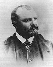
Clarence King
, the first director of USGS, assembled the new organization from disparate regional survey agencies. After a short tenure, King was succeeded in the director's chair by John Wesley Powell
.

The USGS is divided into seven Mission Areas with specific programs including:
s which vary in scale
and extent, with some wide gaps in coverage, notably the complete absence of 1:50,000 scale topographic maps or their equivalent. The largest (both in terms of scale and quantity) and best-known topographic series is the 7.5-minute, 1:24,000 scale, quadrangle
, a non-metric scale virtually unique to the United States. Each of these maps covers an area bounded by two lines of latitude
and two lines of longitude
spaced 7.5 minutes
apart. Nearly 57,000 individual maps in this series cover the 48 contiguous states, Hawaii
, U. S. territories, and areas of Alaska
near Anchorage, Fairbanks, and Prudhoe Bay. The area covered by each map varies with the latitude of its represented location due to convergence of the meridians. At lower latitudes, near 30° north, a 7.5-minute quadrangle contains an area of about 64 square miles (166 km²). At 49° north latitude, 49 square miles (127 km²) are contained within a quadrangle of that size. As a unique non-metric map scale, the 1:24,000 scale naturally requires a separate and specialized romer
scale for plotting map positions. In recent years, budget constraints have forced the USGS to rely on donations of time by civilian volunteers in an attempt to update its 7.5-minute topographic map series, and USGS stated outright in 2000 that the program was to be phased out in favor of The National Map (not to be confused with the National Atlas of the United States
produced by the Department of the Interior
, one of whose bureaus is USGS).
An older series of maps, the 15-minute series, was once used to map the contiguous 48 states at a scale of 1:62,500, but was discontinued some time ago for maps covering the continental U.S. Each map was bounded by two parallels
and two meridians
spaced 15 minutes apart - the same area covered by four maps in the 7.5-minute series. The 15-minute series, at a scale of 1:63,360 (one inch representing one mile), remains the primary topographic quadrangle for the state of Alaska (and only for that particular state). Nearly 3,000 maps cover 97% of the state. The U.S.A. remains virtually the only developed country in the world without a standardized civilian topographic map series in the standard 1:25,000 or 1:50,000 metric scales, making coordination difficult in border regions (the U.S. military does issue 1:50,000 scale topo maps of the continental U.S., though only for use by members of its defense forces).
The next-smallest topographic series, in terms of scale, is the 1:100,000 series. These maps are bounded by two lines of longitude and two lines of latitude. However, in this series, the lines of latitude are spaced 30 minutes apart and the lines of longitude are spaced 60 minutes, which is the source of another name for these maps; the 30 x 60-minute quadrangle series. Each of these quadrangles covers the area contained within 32 maps in the 7.5-minute series. The 1:100,000 scale series is unusual in that it employs the Metric system
primarily. One centimeter on the map represents one kilometer of distance on the ground. Contour intervals
, spot elevations, and horizontal distances are also specified in meters.
The final regular quadrangle series produced by the USGS is the 1:250,000 scale topographic series. Each of these quadrangles in the conterminous United States measures 1 degree of latitude by 2 degrees of longitude. This series was produced by the U.S. Army Map Service in the 1950s, prior to the maps in the larger-scale series, and consists of 489 sheets, each covering an area ranging from 8218 square miles (21,285 km²) at 30° north to 6222 square miles (16,115 km²) at 49° north. Hawaii is mapped at this scale in quadrangles measuring 1° by 1°.
USGS topographic quadrangle maps are marked with grid lines and tics around the map collar which make it possible to identify locations on the map by several methods, including the graticule
measurements of longitude
and latitude
, the township
and section method within the Public Land Survey System
, and cartesian coordinates
in both the State Plane Coordinate System
and the Universal Transverse Mercator coordinate system
.
Other specialty maps have been produced by the USGS at a variety of scales. These include county
maps, maps of special interest areas, such as the national parks, and areas of scientific interest.
A number of Internet sites have made these maps available on the web for affordable commercial and professional use. Because works of the U.S. Government are in the public domain
, it is also possible to find many of these maps for free at various locations on the Internet. Georeference
d map images are available from the USGS as digital raster graphic
s (DRGs) in addition to digital data sets based on USGS maps, notably Digital Line Graph
s (DLGs) and digital elevation model
s (DEMs).
Biological Science Report (BSR)
Record significant scientific interpretations and findings, usually of lasting scientific interest, addressing a wide variety of topics relevant to Biological Resources Discipline (BRD) investigations and research. May include extensive data or theoretical analyses. Reports published by the U.S. Biological Survey and later by the U.S. Geological Survey. The report series began in 1995 and continued through 2003.
Bulletin (B)
Significant data and interpretations of lasting scientific interest but generally narrower in scope than professional papers. Results of resource studies, geologic or topographic studies, and collections of short papers on related topics.
Circular (CIR/C)
A wide variety of topics covered concisely and clearly to provide a synthesis of understanding about processes, geographic areas, issues, or USGS programs. The Circular should be aimed at enhancing knowledge and understanding among general audiences, decision makers, university students, and scientists in related fields.
Circum-Pacific Map (CP)
Multicolor equal-area maps at scales of 1:10,000,000 for the Northwest, Northeast, Southwest, Southeast quadrants of the Pacific and the Arctic and Antarctic regions, and of 1:17,000,000 for the whole Pacific Basin. The series consists of base, geographic, geodynamic, plate-tectonic, geologic, tectonic, mineral-resources, and energy-resources maps, as well as other miscellaneous maps.
Coal Investigations (COAL/C-) Map
Origin, character, and resource potential of coal deposits shown by geologic maps, structure contours, cross sections, columnar sections, and measured coal sections, where appropriate. Text on same sheet or in an accompanying pamphlet.
Data Series (DS)
The Data Series is intended for release of basic data sets, databases, and multimedia or motion graphics. This series can be used for videos, computer programs, and collections of digital photographs.
Folios of the Geologic Atlas (GF)
Quadrangles named from a city, town, or prominent natural feature within the area covered. They include maps showing the topography, geology, underground structure and mineral deposits of the area and several pages of descriptive text and illustrations. May include maps of oil and gas and artesian water. Precursor to Geologic Quadrangles.
General Interest Publication (GIP)
A wide variety of topics covered concisely and clearly in a variety of formats. Focus is on USGS programs, projects, and services and general scientific information of public interest. The series covers a broad range of topics in a variety of media, including pamphlets, postcards, posters, videos, teacher kits, CD/DVDs, bookmarks, and interactive and motion graphics. Previously called "General Interest Publications".
Geologic Quadrangle (GQ) Map
Detailed geologic maps depicting areas of special importance to the solution of geologic problems. May portray bedrock or surficial units, or both. May include brief texts, structure sections, and columnar sections. 71/2- or 15-minute quadrangles printed in multicolor on topographic bases that meet National Map Accuracy standards.
Geophysical Investigations (GP) Map
Chiefly the results of aeromagnetic and (or) gravity surveys shown by contours. Area depicted may range in size from a few square miles to an entire country. Single or multiple sheets.
Hydrologic Investigations Atlas (HA)
A wide range of hydrologic and hydrogeologic data of regional and national interest, such as streamflow, ground water, water quality, and extent of flooding. Various scales. Single or multiple sheets.
Land Use and Land Cover (L) Map
Various categories of land use and cover, both artificial and natural, for use by geographers, land-use planners, and others. Planimetric maps at scales of 1:250,000 or 1:100,000 on a single sheet.
Mineral Investigations Resource (MR) Map
Information on mineral occurrences, mineral resources, mines and prospects, commodities, and target areas of possible resources other than coal, petroleum, or natural gas. Small scale (1:250,000 or smaller).
Miscellaneous Field Studies (MF) Map
Rapidly prepared, low-budget maps in a broad range of presentations in terms of portrayal, completeness, interpretations, draftsmanship, scale, and area coverage. Single or multiple sheets.
Miscellaneous Investigations/ Geologic Investigations (I) Series
High-quality maps and charts of varied subject matter such as bathymetry, geology, hydrogeology, landforms, land-use classification, vegetation, and others including maps of planets, the Moon, and other satellites. Various scales. Topographic or planimetric bases; regular or irregular areas. May include a text printed as an accompanying pamphlet.
Oil and Gas Investigations (OC) Chart
Information about known or possible petroleum resources, presented as logs, correlation diagrams, graphs, and tables, but ordinarily not as maps. Single or multiple sheets. Text printed on same sheet or in an accompanying pamphlet.
Oil and Gas Investigations (OM) Map
Apply particularly to areas of known or possible petroleum resources. Typically include cross sections, columnar sections, structure contours, correlation diagrams, and information on wells drilled for oil and gas. Single or multiple sheets. Text usually on map sheet but sometimes printed as an accompanying pamphlet.
Open-File Report (OFR/OF)
Interpretive information that needs to be released immediately; maps and reports (and their supporting data) that need to be released as supporting documentation because they are referenced, discussed, or interpreted in another information product; preliminary findings (pending a final map or report); interim computer programs and user guides; bibliographies.
Professional Paper (PP)
Premier series of the USGS. Comprehensive reports of wide and lasting interest and scientific importance, characterized by thoroughness of study and breadth of scientific or geographic coverage. The series may include collections of related papers addressing different aspects of a single scientific topic, either issued together under one cover or separately as chapters.
Water-Resources Investigations Report (WRIR/WRI)
Hydrologic information, mainly of local interest, intended for quick release. Book or map format. Varied scales.
Water-Supply Paper (WSP)
Reports on all aspects of hydrology, including quality, recoverability, and use of water resources; statistical reports on streamflow, floods, groundwater levels, and water quality; and collections of short papers on related topics.
A complete listing of descriptions of USGS Series is available at
http://infotrek.er.usgs.gov/pls/htmldb/f?p=127:13:1996281797770541 (accessed 11/25/08)
Locating USGS Publications
USGS publication are available for purchase at USGS Publications Warehouse.
Many USGS publications are now available online:
Many older USGS publications have been scanned and digitized by such services as Google Books. An online search will quickly reveal if a digital version is available. All USGS publications are public domain
.
The revision was claimed not to change existing rules, but rather to emphasize the importance of maintaining the scientific integrity of the agency's work by requiring scientists to accept comments from the public and follow administrative policies. However, scientists have questioned whether this revision is likely to facilitate censorship of their work, as has been alleged by critics to have occurred in some federal agencies under the administration of United States President George W. Bush.
According to the authors of this policy, USGS information is given to the public after it has been through a peer review and approval process. USGS leadership and communications staff are kept informed of relevant scientific findings so they can manage the flow of information to decision-makers, who use this information to make resource-management choices. Policy makers have said these principles and practices will bolster the USGS’s scientific objectivity and reputation.
Non-USGS related sites
Scientist
A scientist in a broad sense is one engaging in a systematic activity to acquire knowledge. In a more restricted sense, a scientist is an individual who uses the scientific method. The person may be an expert in one or more areas of science. This article focuses on the more restricted use of the word...
s of the USGS study the landscape
Landscape
Landscape comprises the visible features of an area of land, including the physical elements of landforms such as mountains, hills, water bodies such as rivers, lakes, ponds and the sea, living elements of land cover including indigenous vegetation, human elements including different forms of...
of the United States
United States
The United States of America is a federal constitutional republic comprising fifty states and a federal district...
, its natural resource
Natural resource
Natural resources occur naturally within environments that exist relatively undisturbed by mankind, in a natural form. A natural resource is often characterized by amounts of biodiversity and geodiversity existent in various ecosystems....
s, and the natural hazard
Natural hazard
A natural hazard is a threat of a naturally occurring event that will have a negative effect on people or the environment. Many natural hazards are interrelated, e.g. earthquakes can cause tsunamis and drought can lead directly to famine. It is possible that some natural hazards are...
s that threaten it. The organization has four major science disciplines, concerning biology
Biology
Biology is a natural science concerned with the study of life and living organisms, including their structure, function, growth, origin, evolution, distribution, and taxonomy. Biology is a vast subject containing many subdivisions, topics, and disciplines...
, geography
Geography
Geography is the science that studies the lands, features, inhabitants, and phenomena of Earth. A literal translation would be "to describe or write about the Earth". The first person to use the word "geography" was Eratosthenes...
, geology
Geology
Geology is the science comprising the study of solid Earth, the rocks of which it is composed, and the processes by which it evolves. Geology gives insight into the history of the Earth, as it provides the primary evidence for plate tectonics, the evolutionary history of life, and past climates...
, and hydrology
Hydrology
Hydrology is the study of the movement, distribution, and quality of water on Earth and other planets, including the hydrologic cycle, water resources and environmental watershed sustainability...
. The USGS is a fact-finding research organization with no regulatory responsibility.
A bureau of the United States Department of the Interior
United States Department of the Interior
The United States Department of the Interior is the United States federal executive department of the U.S. government responsible for the management and conservation of most federal land and natural resources, and the administration of programs relating to Native Americans, Alaska Natives, Native...
, it is that department's sole scientific agency. The USGS employs approximately 8,670 people and is headquartered in Reston, Virginia
Reston, Virginia
Reston is a census-designated place in Fairfax County, Virginia, United States, within the Washington, D.C. metropolitan area. The population was 58,404, at the 2010 Census and 56,407 at the 2000 census...
. The USGS also has major offices in Lakewood, Colorado
Lakewood, Colorado
Lakewood is a Home Rule Municipality that is the most populous city in Jefferson County, Colorado, United States. Lakewood is the fifth most populous city in the State of Colorado and the 172nd most populous city in the United States. The United States Census Bureau estimates that in April 1, 2010...
(Denver Federal Center
Denver Federal Center
Denver Federal Center is located in Lakewood, Colorado and is the home to about 6,200 employees for many Federal government of the United States agencies. The Denver Federal Center encompasses an area of about and has 90 buildings comprising over of office, warehouse, lab and special use space...
), and Menlo Park, California
Menlo Park, California
Menlo Park, California is a city at the eastern edge of San Mateo County, in the San Francisco Bay Area of California, in the United States. It is bordered by San Francisco Bay on the north and east; East Palo Alto, Palo Alto, and Stanford to the south; Atherton, North Fair Oaks, and Redwood City...
.
The motto of the USGS is "Science for a changing world."
History
Prompted by a report from the National Academy of SciencesUnited States National Academy of Sciences
The National Academy of Sciences is a corporation in the United States whose members serve pro bono as "advisers to the nation on science, engineering, and medicine." As a national academy, new members of the organization are elected annually by current members, based on their distinguished and...
the USGS was created by an act of Congress
United States Congress
The United States Congress is the bicameral legislature of the federal government of the United States, consisting of the Senate and the House of Representatives. The Congress meets in the United States Capitol in Washington, D.C....
on March 3, 1879. It was charged with the "classification of the public lands, and examination of the geological structure, mineral resources, and products of the national domain." This task was driven by the need to inventory the vast lands added to the United States by the Louisiana Purchase
Louisiana Purchase
The Louisiana Purchase was the acquisition by the United States of America of of France's claim to the territory of Louisiana in 1803. The U.S...
in 1803 and the Mexican-American War in 1848.
Clarence King
Clarence King
Clarence R. King was an American geologist, mountaineer, and art critic. First director of the United States Geological Survey, from 1879 to 1881, King was noted for his exploration of the Sierra Nevada. He was born in Newport, Rhode Island.-Career:...
, the first director of USGS, assembled the new organization from disparate regional survey agencies. After a short tenure, King was succeeded in the director's chair by John Wesley Powell
John Wesley Powell
John Wesley Powell was a U.S. soldier, geologist, explorer of the American West, and director of major scientific and cultural institutions...
.
List of USGS Directors
|
Programs
The USGS is divided into seven Mission Areas with specific programs including:
- Earthquake Hazards Program monitors earthquakeEarthquakeAn earthquake is the result of a sudden release of energy in the Earth's crust that creates seismic waves. The seismicity, seismism or seismic activity of an area refers to the frequency, type and size of earthquakes experienced over a period of time...
activity worldwide. The National Earthquake Information CenterNational Earthquake Information CenterThe National Earthquake Information Center is part of the United States Geological Survey located on the campus of the Colorado School of Mines in Golden, Colorado. The NEIC has three main missions:...
(NEIC) in Golden, ColoradoGolden, ColoradoThe City of Golden is a home rule municipality that is the county seat of Jefferson County, Colorado, United States. Golden lies along Clear Creek at the edge of the foothills of the Front Range of the Rocky Mountains. Founded during the Pike's Peak Gold Rush on 16 June 1859, the mining camp was...
on the campus of the Colorado School of MinesColorado School of MinesThe Colorado School of Mines is a small public teaching and research university devoted to engineering and applied science, with special expertise in the development and stewardship of the Earth's natural resources. Located in Golden, Colorado, CSM was ranked 29th, in America among national...
detects the location and magnitude of global earthquakes. The USGS also runs or supports several regional monitoring networks in the U.S. under the umbrella of the Advanced National Seismic System (ANSS). The USGS informs authorities, emergency responders, the media, and the public, both domestic and worldwide, about significant earthquakes. It also maintains long-term archives of earthquake data for scientific and engineering research. It also conducts and supports research on long-term seismic hazardSeismic hazardSeismic hazard refers to the study of expected earthquake ground motions at the earth's surface, and its likely effects on existing natural conditions and man-made structures for public safety considerations; the results of such studies are published as seismic hazard maps, which identify the...
s. - As of 2005, the agency is working to create a National Volcano Early Warning System by improving the instrumentation monitoring the 169 volcanoVolcano2. Bedrock3. Conduit 4. Base5. Sill6. Dike7. Layers of ash emitted by the volcano8. Flank| 9. Layers of lava emitted by the volcano10. Throat11. Parasitic cone12. Lava flow13. Vent14. Crater15...
es in U.S. territory and by establishing methods for measuring the relative threats posed at each site. - The USGS National Geomagnetism ProgramNational Geomagnetism ProgramThe National Geomagnetism Program is a program directed by the USGS that monitors the Earth's magnetic field....
monitors the magnetic fieldMagnetic fieldA magnetic field is a mathematical description of the magnetic influence of electric currents and magnetic materials. The magnetic field at any given point is specified by both a direction and a magnitude ; as such it is a vector field.Technically, a magnetic field is a pseudo vector;...
at magnetic observatories and distributes magnetometerMagnetometerA magnetometer is a measuring instrument used to measure the strength or direction of a magnetic field either produced in the laboratory or existing in nature...
data in real time. - The USGS collaborates with Canadian and MexicanMexicoThe United Mexican States , commonly known as Mexico , is a federal constitutional republic in North America. It is bordered on the north by the United States; on the south and west by the Pacific Ocean; on the southeast by Guatemala, Belize, and the Caribbean Sea; and on the east by the Gulf of...
government scientists, along with the Commission for Environmental CooperationCommission for Environmental CooperationThe Commission for Environmental Cooperation was established by Canada, Mexico, and the United States to implement the North American Agreement on Environmental Cooperation , the environmental side accord to the North American Free Trade Agreement...
, to produce the North American Environmental AtlasNorth American Environmental AtlasThe North American Environmental Atlas is an interactive mapping tool created through a partnership of government agencies in Canada, Mexico and the United States, along with the Commission for Environmental Cooperation, a trilateral international organization created under the North American...
, which is used to depict and track environmental issues for a continental perspective. - The USGS operates the streamgaging network for the United States, with over 7400 streamgagesStream gaugeA stream gauge, stream gage or gauging station is a location used by hydrologists or environmental scientists to monitor and test terrestrial bodies of water. Hydrometric measurements of water surface elevation and/or volumetric discharge are generally taken and observations of biota may also be...
. Real-time streamflow data are available online. - National Climate Change and Wildlife Science Center (NCCWSC) implements partner-driven science to improve understanding of past and present land use change, develops relevant climate and land use forecasts, and identifies lands, resources, and communities that are most vulnerable to adverse impacts of change from the local to global scale.
- Since 1962, the Astrogeology Research ProgramAstrogeology Research ProgramThe USGS Astrogeology Science Center has a rich history of participation in space exploration efforts and planetary mapping, starting in 1963 when the Flagstaff Science Center was established by Gene Shoemaker to provide lunar geologic mapping and assist in training astronauts destined for the...
has been involved in global, lunarMoonThe Moon is Earth's only known natural satellite,There are a number of near-Earth asteroids including 3753 Cruithne that are co-orbital with Earth: their orbits bring them close to Earth for periods of time but then alter in the long term . These are quasi-satellites and not true moons. For more...
and planetPlanetA planet is a celestial body orbiting a star or stellar remnant that is massive enough to be rounded by its own gravity, is not massive enough to cause thermonuclear fusion, and has cleared its neighbouring region of planetesimals.The term planet is ancient, with ties to history, science,...
ary exploration and mapMapA map is a visual representation of an area—a symbolic depiction highlighting relationships between elements of that space such as objects, regions, and themes....
ping. - In collaboration with Stanford UniversityStanford UniversityThe Leland Stanford Junior University, commonly referred to as Stanford University or Stanford, is a private research university on an campus located near Palo Alto, California. It is situated in the northwestern Santa Clara Valley on the San Francisco Peninsula, approximately northwest of San...
, the USGS also operates the USGS-Stanford Ion Microprobe Laboratory, a world-class analytical facility for U-(Th)-Pb geochronologyGeochronologyGeochronology is the science of determining the age of rocks, fossils, and sediments, within a certain degree of uncertainty inherent to the method used. A variety of dating methods are used by geologists to achieve this, and schemes of classification and terminology have been proposed...
and trace element analyses of minerals and other earth materials. - USGS operates a number of water related programs, notably the National Streamflow Information Program and National Water-Quality Assessment Program. USGS Water data is publicly available from their National Water Information System database.
- The USGS also operates the National Wildlife Health Center, whose mission is "to serve the nation and its natural resources by providing sound science and technical support, and to disseminate information to promote science-based decisions affecting wildlife and ecosystem health. The NWHC provides information, technical assistance, research, education, and leadership on national and international wildlife health issues." It is the agency primarily responsible for surveillance of wild-animal H5N1H5N1Influenza A virus subtype H5N1, also known as "bird flu", A or simply H5N1, is a subtype of the influenza A virus which can cause illness in humans and many other animal species...
avian influenza outbreaks in the United States. The USGS also runs 17 biological research centers in the United States, including the Patuxent Wildlife Research CenterPatuxent Wildlife Research CenterThe Patuxent Wildlife Research Center is a biological research center in Maryland. It is one of only 17 research centers in the United States run by the U.S. Geological Survey. This USGS research center is located on the U.S...
.
Topographic Mapping
The United States Geological Survey (USGS), a civilian federal agency, produces several national series of topographic mapTopographic map
A topographic map is a type of map characterized by large-scale detail and quantitative representation of relief, usually using contour lines in modern mapping, but historically using a variety of methods. Traditional definitions require a topographic map to show both natural and man-made features...
s which vary in scale
Scale (map)
The scale of a map is defined as the ratio of a distance on the map to the corresponding distance on the ground.If the region of the map is small enough for the curvature of the Earth to be neglected, then the scale may be taken as a constant ratio over the whole map....
and extent, with some wide gaps in coverage, notably the complete absence of 1:50,000 scale topographic maps or their equivalent. The largest (both in terms of scale and quantity) and best-known topographic series is the 7.5-minute, 1:24,000 scale, quadrangle
Quadrilateral
In Euclidean plane geometry, a quadrilateral is a polygon with four sides and four vertices or corners. Sometimes, the term quadrangle is used, by analogy with triangle, and sometimes tetragon for consistency with pentagon , hexagon and so on...
, a non-metric scale virtually unique to the United States. Each of these maps covers an area bounded by two lines of latitude
Latitude
In geography, the latitude of a location on the Earth is the angular distance of that location south or north of the Equator. The latitude is an angle, and is usually measured in degrees . The equator has a latitude of 0°, the North pole has a latitude of 90° north , and the South pole has a...
and two lines of longitude
Longitude
Longitude is a geographic coordinate that specifies the east-west position of a point on the Earth's surface. It is an angular measurement, usually expressed in degrees, minutes and seconds, and denoted by the Greek letter lambda ....
spaced 7.5 minutes
Minute of arc
A minute of arc, arcminute, or minute of angle , is a unit of angular measurement equal to one sixtieth of one degree. In turn, a second of arc or arcsecond is one sixtieth of one minute of arc....
apart. Nearly 57,000 individual maps in this series cover the 48 contiguous states, Hawaii
Hawaii
Hawaii is the newest of the 50 U.S. states , and is the only U.S. state made up entirely of islands. It is the northernmost island group in Polynesia, occupying most of an archipelago in the central Pacific Ocean, southwest of the continental United States, southeast of Japan, and northeast of...
, U. S. territories, and areas of Alaska
Alaska
Alaska is the largest state in the United States by area. It is situated in the northwest extremity of the North American continent, with Canada to the east, the Arctic Ocean to the north, and the Pacific Ocean to the west and south, with Russia further west across the Bering Strait...
near Anchorage, Fairbanks, and Prudhoe Bay. The area covered by each map varies with the latitude of its represented location due to convergence of the meridians. At lower latitudes, near 30° north, a 7.5-minute quadrangle contains an area of about 64 square miles (166 km²). At 49° north latitude, 49 square miles (127 km²) are contained within a quadrangle of that size. As a unique non-metric map scale, the 1:24,000 scale naturally requires a separate and specialized romer
Romer
A Reference Card or "Romer" is a device for increasing the accuracy when reading a grid reference from a map. Made from transparent plastic, paper or other materials, they are also found on most baseplate compasses. Essentially, it is a specially marked-out ruler which matches the scale of the map...
scale for plotting map positions. In recent years, budget constraints have forced the USGS to rely on donations of time by civilian volunteers in an attempt to update its 7.5-minute topographic map series, and USGS stated outright in 2000 that the program was to be phased out in favor of The National Map (not to be confused with the National Atlas of the United States
National Atlas of the United States
The National Atlas of the United States is an online atlas published by the United States Department of the Interior.Since it is a publication of the United States Government, the atlas and the maps contained therein are in the public domain....
produced by the Department of the Interior
United States Department of the Interior
The United States Department of the Interior is the United States federal executive department of the U.S. government responsible for the management and conservation of most federal land and natural resources, and the administration of programs relating to Native Americans, Alaska Natives, Native...
, one of whose bureaus is USGS).
An older series of maps, the 15-minute series, was once used to map the contiguous 48 states at a scale of 1:62,500, but was discontinued some time ago for maps covering the continental U.S. Each map was bounded by two parallels
Latitude
In geography, the latitude of a location on the Earth is the angular distance of that location south or north of the Equator. The latitude is an angle, and is usually measured in degrees . The equator has a latitude of 0°, the North pole has a latitude of 90° north , and the South pole has a...
and two meridians
Longitude
Longitude is a geographic coordinate that specifies the east-west position of a point on the Earth's surface. It is an angular measurement, usually expressed in degrees, minutes and seconds, and denoted by the Greek letter lambda ....
spaced 15 minutes apart - the same area covered by four maps in the 7.5-minute series. The 15-minute series, at a scale of 1:63,360 (one inch representing one mile), remains the primary topographic quadrangle for the state of Alaska (and only for that particular state). Nearly 3,000 maps cover 97% of the state. The U.S.A. remains virtually the only developed country in the world without a standardized civilian topographic map series in the standard 1:25,000 or 1:50,000 metric scales, making coordination difficult in border regions (the U.S. military does issue 1:50,000 scale topo maps of the continental U.S., though only for use by members of its defense forces).
The next-smallest topographic series, in terms of scale, is the 1:100,000 series. These maps are bounded by two lines of longitude and two lines of latitude. However, in this series, the lines of latitude are spaced 30 minutes apart and the lines of longitude are spaced 60 minutes, which is the source of another name for these maps; the 30 x 60-minute quadrangle series. Each of these quadrangles covers the area contained within 32 maps in the 7.5-minute series. The 1:100,000 scale series is unusual in that it employs the Metric system
Metric system
The metric system is an international decimalised system of measurement. France was first to adopt a metric system, in 1799, and a metric system is now the official system of measurement, used in almost every country in the world...
primarily. One centimeter on the map represents one kilometer of distance on the ground. Contour intervals
Contour line
A contour line of a function of two variables is a curve along which the function has a constant value. In cartography, a contour line joins points of equal elevation above a given level, such as mean sea level...
, spot elevations, and horizontal distances are also specified in meters.
The final regular quadrangle series produced by the USGS is the 1:250,000 scale topographic series. Each of these quadrangles in the conterminous United States measures 1 degree of latitude by 2 degrees of longitude. This series was produced by the U.S. Army Map Service in the 1950s, prior to the maps in the larger-scale series, and consists of 489 sheets, each covering an area ranging from 8218 square miles (21,285 km²) at 30° north to 6222 square miles (16,115 km²) at 49° north. Hawaii is mapped at this scale in quadrangles measuring 1° by 1°.
USGS topographic quadrangle maps are marked with grid lines and tics around the map collar which make it possible to identify locations on the map by several methods, including the graticule
Geographic coordinate system
A geographic coordinate system is a coordinate system that enables every location on the Earth to be specified by a set of numbers. The coordinates are often chosen such that one of the numbers represent vertical position, and two or three of the numbers represent horizontal position...
measurements of longitude
Longitude
Longitude is a geographic coordinate that specifies the east-west position of a point on the Earth's surface. It is an angular measurement, usually expressed in degrees, minutes and seconds, and denoted by the Greek letter lambda ....
and latitude
Latitude
In geography, the latitude of a location on the Earth is the angular distance of that location south or north of the Equator. The latitude is an angle, and is usually measured in degrees . The equator has a latitude of 0°, the North pole has a latitude of 90° north , and the South pole has a...
, the township
Survey township
Survey township, sometimes called Congressional township, as used by the United States Public Land Survey System, refers to a square unit of land, that is nominally six miles on a side...
and section method within the Public Land Survey System
Public Land Survey System
The Public Land Survey System is a method used in the United States to survey and identify land parcels, particularly for titles and deeds of rural, wild or undeveloped land. Its basic units of area are the township and section. It is sometimes referred to as the rectangular survey system,...
, and cartesian coordinates
Cartesian coordinate system
A Cartesian coordinate system specifies each point uniquely in a plane by a pair of numerical coordinates, which are the signed distances from the point to two fixed perpendicular directed lines, measured in the same unit of length...
in both the State Plane Coordinate System
State Plane Coordinate System
The State Plane Coordinate System is a set of 124 geographic zones or coordinate systems designed for specific regions of the United States. Each state contains one or more state plane zones, the boundaries of which usually follow county lines...
and the Universal Transverse Mercator coordinate system
Universal Transverse Mercator coordinate system
The Universal Transverse Mercator geographic coordinate system uses a 2-dimensional Cartesian coordinate system to give locations on the surface of the Earth. It is a horizontal position representation, i.e...
.
Other specialty maps have been produced by the USGS at a variety of scales. These include county
County (United States)
In the United States, a county is a geographic subdivision of a state , usually assigned some governmental authority. The term "county" is used in 48 of the 50 states; Louisiana is divided into parishes and Alaska into boroughs. Parishes and boroughs are called "county-equivalents" by the U.S...
maps, maps of special interest areas, such as the national parks, and areas of scientific interest.
A number of Internet sites have made these maps available on the web for affordable commercial and professional use. Because works of the U.S. Government are in the public domain
Public domain
Works are in the public domain if the intellectual property rights have expired, if the intellectual property rights are forfeited, or if they are not covered by intellectual property rights at all...
, it is also possible to find many of these maps for free at various locations on the Internet. Georeference
Georeference
To georeference something means to define its existence in physical space. That is, establishing its location in terms of map projections or coordinate systems. The term is used both when establishing the relation between raster or vector images and coordinates, and when determining the spatial...
d map images are available from the USGS as digital raster graphic
Digital raster graphic
A digital raster graphic is a digital image resulting from scanning a paper USGS topographic map for use on a computer. DRGs created by USGS are typically scanned at 250 dpi and saved as a TIFF. The raster image usually includes the original border information, referred to as the "map collar". ...
s (DRGs) in addition to digital data sets based on USGS maps, notably Digital Line Graph
Digital line graph
A Digital Line Graph is a cartographic map feature represented in digital vector form that is distributed by the U.S. Geological Survey . DLGs are collected from USGS maps and are distributed in large-, intermediate- and small-scale with up to nine different categories of features, depending on...
s (DLGs) and digital elevation model
Digital elevation model
A digital elevation model is a digital model or 3-D representation of a terrain's surface — commonly for a planet , moon, or asteroid — created from terrain elevation data....
s (DEMs).
USGS publications
USGS publishes many series of maps and reports, including:Biological Science Report (BSR)
Record significant scientific interpretations and findings, usually of lasting scientific interest, addressing a wide variety of topics relevant to Biological Resources Discipline (BRD) investigations and research. May include extensive data or theoretical analyses. Reports published by the U.S. Biological Survey and later by the U.S. Geological Survey. The report series began in 1995 and continued through 2003.
Bulletin (B)
Significant data and interpretations of lasting scientific interest but generally narrower in scope than professional papers. Results of resource studies, geologic or topographic studies, and collections of short papers on related topics.
Circular (CIR/C)
A wide variety of topics covered concisely and clearly to provide a synthesis of understanding about processes, geographic areas, issues, or USGS programs. The Circular should be aimed at enhancing knowledge and understanding among general audiences, decision makers, university students, and scientists in related fields.
Circum-Pacific Map (CP)
Multicolor equal-area maps at scales of 1:10,000,000 for the Northwest, Northeast, Southwest, Southeast quadrants of the Pacific and the Arctic and Antarctic regions, and of 1:17,000,000 for the whole Pacific Basin. The series consists of base, geographic, geodynamic, plate-tectonic, geologic, tectonic, mineral-resources, and energy-resources maps, as well as other miscellaneous maps.
Coal Investigations (COAL/C-) Map
Origin, character, and resource potential of coal deposits shown by geologic maps, structure contours, cross sections, columnar sections, and measured coal sections, where appropriate. Text on same sheet or in an accompanying pamphlet.
Data Series (DS)
The Data Series is intended for release of basic data sets, databases, and multimedia or motion graphics. This series can be used for videos, computer programs, and collections of digital photographs.
Folios of the Geologic Atlas (GF)
Quadrangles named from a city, town, or prominent natural feature within the area covered. They include maps showing the topography, geology, underground structure and mineral deposits of the area and several pages of descriptive text and illustrations. May include maps of oil and gas and artesian water. Precursor to Geologic Quadrangles.
General Interest Publication (GIP)
A wide variety of topics covered concisely and clearly in a variety of formats. Focus is on USGS programs, projects, and services and general scientific information of public interest. The series covers a broad range of topics in a variety of media, including pamphlets, postcards, posters, videos, teacher kits, CD/DVDs, bookmarks, and interactive and motion graphics. Previously called "General Interest Publications".
Geologic Quadrangle (GQ) Map
Detailed geologic maps depicting areas of special importance to the solution of geologic problems. May portray bedrock or surficial units, or both. May include brief texts, structure sections, and columnar sections. 71/2- or 15-minute quadrangles printed in multicolor on topographic bases that meet National Map Accuracy standards.
Geophysical Investigations (GP) Map
Chiefly the results of aeromagnetic and (or) gravity surveys shown by contours. Area depicted may range in size from a few square miles to an entire country. Single or multiple sheets.
Hydrologic Investigations Atlas (HA)
A wide range of hydrologic and hydrogeologic data of regional and national interest, such as streamflow, ground water, water quality, and extent of flooding. Various scales. Single or multiple sheets.
Land Use and Land Cover (L) Map
Various categories of land use and cover, both artificial and natural, for use by geographers, land-use planners, and others. Planimetric maps at scales of 1:250,000 or 1:100,000 on a single sheet.
Mineral Investigations Resource (MR) Map
Information on mineral occurrences, mineral resources, mines and prospects, commodities, and target areas of possible resources other than coal, petroleum, or natural gas. Small scale (1:250,000 or smaller).
Miscellaneous Field Studies (MF) Map
Rapidly prepared, low-budget maps in a broad range of presentations in terms of portrayal, completeness, interpretations, draftsmanship, scale, and area coverage. Single or multiple sheets.
Miscellaneous Investigations/ Geologic Investigations (I) Series
High-quality maps and charts of varied subject matter such as bathymetry, geology, hydrogeology, landforms, land-use classification, vegetation, and others including maps of planets, the Moon, and other satellites. Various scales. Topographic or planimetric bases; regular or irregular areas. May include a text printed as an accompanying pamphlet.
Oil and Gas Investigations (OC) Chart
Information about known or possible petroleum resources, presented as logs, correlation diagrams, graphs, and tables, but ordinarily not as maps. Single or multiple sheets. Text printed on same sheet or in an accompanying pamphlet.
Oil and Gas Investigations (OM) Map
Apply particularly to areas of known or possible petroleum resources. Typically include cross sections, columnar sections, structure contours, correlation diagrams, and information on wells drilled for oil and gas. Single or multiple sheets. Text usually on map sheet but sometimes printed as an accompanying pamphlet.
Open-File Report (OFR/OF)
Interpretive information that needs to be released immediately; maps and reports (and their supporting data) that need to be released as supporting documentation because they are referenced, discussed, or interpreted in another information product; preliminary findings (pending a final map or report); interim computer programs and user guides; bibliographies.
Professional Paper (PP)
Premier series of the USGS. Comprehensive reports of wide and lasting interest and scientific importance, characterized by thoroughness of study and breadth of scientific or geographic coverage. The series may include collections of related papers addressing different aspects of a single scientific topic, either issued together under one cover or separately as chapters.
Water-Resources Investigations Report (WRIR/WRI)
Hydrologic information, mainly of local interest, intended for quick release. Book or map format. Varied scales.
Water-Supply Paper (WSP)
Reports on all aspects of hydrology, including quality, recoverability, and use of water resources; statistical reports on streamflow, floods, groundwater levels, and water quality; and collections of short papers on related topics.
A complete listing of descriptions of USGS Series is available at
http://infotrek.er.usgs.gov/pls/htmldb/f?p=127:13:1996281797770541 (accessed 11/25/08)
Locating USGS Publications
USGS publication are available for purchase at USGS Publications Warehouse.
Many USGS publications are now available online:
- USGS Publications Warehouse, Search for online documents
- Open-File reports online, accessed 11/25/08
- Mineral Resources Program, Online Publications and Data
- Central Mineral Resources Team, selected maps and publications online
- National Strong-Motion Project Reports and software online.
Many older USGS publications have been scanned and digitized by such services as Google Books. An online search will quickly reveal if a digital version is available. All USGS publications are public domain
Public domain
Works are in the public domain if the intellectual property rights have expired, if the intellectual property rights are forfeited, or if they are not covered by intellectual property rights at all...
.
Controversy
In December 2006, it was announced that the rules for the publication of USGS research were being revised. Employees were informed that USGS leadership and communications staff should be notified "of findings or data that may be especially newsworthy, have an impact on government policy, or contradict previous public understanding to ensure that proper officials are notified and that communication strategies are developed."The revision was claimed not to change existing rules, but rather to emphasize the importance of maintaining the scientific integrity of the agency's work by requiring scientists to accept comments from the public and follow administrative policies. However, scientists have questioned whether this revision is likely to facilitate censorship of their work, as has been alleged by critics to have occurred in some federal agencies under the administration of United States President George W. Bush.
According to the authors of this policy, USGS information is given to the public after it has been through a peer review and approval process. USGS leadership and communications staff are kept informed of relevant scientific findings so they can manage the flow of information to decision-makers, who use this information to make resource-management choices. Policy makers have said these principles and practices will bolster the USGS’s scientific objectivity and reputation.
See also
- Core research centerCore Research CenterThe Core Research Center is a facility run by the United States Geological Survey, located in "F" bay in building 810 on the Denver Federal Center campus. It is maintained by the USGS to preserve valuable rock cores, well cuttings and various other geologic samples for use by scientists and...
- Geographic Names Information System
- Maps of the United States
- National LIDAR Dataset - USA
- QuakeSimQuakeSimQuakeSim is a NASA project for modeling earthquake fault systems. It was started in 2001 with NASA funding as a follow up to the General Earthquake Models initiative. The multi-scale nature of earthquakes requires integrating data types and models to fully simulate and understand the earthquake...
- Timeline of environmental eventsTimeline of environmental eventsThe timeline lists geological, astronomical, and climatological events in relation to events in human history which they influenced. For the history of humanity's perspective on these events, see timeline of the history of environmentalism...
- Volcano Disaster Assistance ProgramVolcano Disaster Assistance ProgramThe Volcano Disaster Assistance Program was developed by the U.S. Geological Survey and U.S. Office of Foreign Disaster Assistance after the eruption of Nevado del Ruiz in 1985 that killed 23,000 people...
- Hawaiian Volcano ObservatoryHawaiian Volcano ObservatoryThe Hawaiian Volcano Observatory is a volcano observatory located at Uwekahuna Bluff on the rim of Kīlauea Caldera on the Island of Hawaii. The observatory monitors four active Hawaiian volcanoes: Kīlauea, Mauna Loa, Hualālai, and Haleakalā...
External links
USGS sites- USGS official site
- Major USGS Mission Area sites: Water, Energy, Minerals, and Environmental Health, Climate and Land Use Change, Ecosystems, Natural Hazards, Core Science Systems
- Science Quality and Integrity
- USGS Fundamental Science Practices
- USGS Library
- Science Topics (thematic directory)
- Science in Your Backyard (State index)
- USGS Circular 1050 (History of the USGS)
- USGS Geomagnetism Program
- Earthquake Hazards Program (current and historical earthquake information)
- Subscribe to automated earthquake messages
- Volcano Information
- Invasive Species
- Land Remote Sensing
- USGS Realtime Streamflow Information
- USGS Water Data for the Nation
Non-USGS related sites
- The Libre Map Project offers free, high-quality USGS DRG maps in TIFF format along with world files for use with your GIS software
- Microsoft Research Maps (formerly TerraServer-USA) and Acme host USGS topographic maps (and aerial photos on Microsoft Research Maps);
- Maptech hosts historical USGS topos in the northeast U.S.
- Mapfinder Utility download USGS Topographic maps for free in Tiff format using Google Earth.
- The US Minerals Databrowser provides interactive access to data visualizations based on data from USGS DS140: "Historical Statistics for Mineral Commodities"