

Tipton County, Tennessee
Encyclopedia
Tipton County is a county located on the western end of the U.S. state
of Tennessee
. As of 2000, the population was 51,271. Its county seat
is Covington
. Tipton County is part of the Memphis
, TN–MS
–AR
Metropolitan Statistical Area
, centered on Shelby County
, which borders Tipton on the south.
, where Tennessee meets Arkansas
; however, in several places where the river's course was altered by the 1812 New Madrid earthquake, the boundary still follows the old alignment of the river, with the result that a few of Tipton County's communities — including Reverie
and Corona
— are exclaved on the Arkansas side, rather than the Tennessee side, of the river.
According to the U.S. Census Bureau
, the county has a total area of 475 square miles (1,230.2 km²), of which 459 square miles (1,188.8 km²) is land and 15 square miles (38.8 km²) (3.23%) is water.
Tipton County is situated on the southeastern edge of the New Madrid Seismic Zone
, an area with a high earthquake
risk.
, Paleo-Indians and later Archaic-Indians lived as communities of hunter-gatherer
s in the area that covers the modern day southern United States
. Approximately 800 CE
to 1600 CE, the Mississippi River Delta
was populated by tribes of the Mississippian culture
, a mound-building Native American
people that had developed in the late Woodland Indian
period.
The Tipton Phase
people were a local expression of the Mississippian culture. They inhabited the region of modern day Tipton County during the time of first contact with Europeans, at the arrival of the de Soto Expedition. By the end of the Mississippian period the land was claimed and populated by the Chickasaw tribe
. The exact origins of the Chickasaw are uncertain.
Around 1800, Europeans
began settling the land east of the Mississippi River
that was inhabited by the Chickasaw
Indians for centuries prior to the arrival of Europeans. Chickasaw land in West Tennessee
and southwestern Kentucky
was ceded in the Jackson Purchase
. In 1818, both sides agreed to the transfer by signing the Treaty of Tuscaloosa.
changes caused by the New Madrid earthquake
s in 1811 and 1812, part of what is now Tipton County was cut off the state of Tennessee by a change in the course of the Mississippi River
. The earthquake changed the course of the Mississippi River near the settlement of Reverie, Tennessee
. The old riverbed is west of Reverie. The current river is east of Reverie. This puts Reverie on the Arkansas
side, while most of the area of Tipton County is located east of the Mississippi River, the Tennessee side.
, which borders Tipton County in the south. The land was derived from what previously had been Chickasaw Indian
lands. The county was named for Jacob Tipton, father of Armistead Blevins, who supervised the organization of Shelby County. Tipton was killed by Native Americans
in 1791 in a conflict over the Northwest Territory
.
 Early Mississippi River
steamboat commerce flourished in Tipton County. In 1830, the community of Randolph
, one of the earliest settlements in Tipton County, was the most important shipping point in Tennessee and an early rival of Memphis
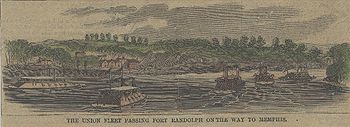
over commercial supremacy, but the fortunes declined in later years. Two Civil War
forts were built near the settlement because of its strategical location on top of the second Chickasaw Bluff
of the Mississippi River, Fort Randolph
and Fort Wright
.
The first rail service in Tipton County was established in December 1855, when the Memphis and Ohio Railroad completed the route from Memphis
to Nashville
, running through what is now Mason
. The Memphis and Paducah Railroad completed the tracks to Covington in July 1873. A telegraph line between Memphis and Covington was opened in 1882. In 1894, Covington was connected to electricity
. Forced water mains provided residents of Covington with water since 1898. In 1922, street paving began in the county seat and since 1929, residents of Covington have access to natural gas
.
In the South Main Historic District in Covington, about 50 residences from the late 19th century and the early 20th century are still intact.
of 2000, there were 51,271 people, 18,106 households, and 14,176 families residing in the county. The population density
was 112 people per square mile (43/km²). There were 19,064 housing units at an average density of 42 per square mile (16/km²). The racial makeup of the county was 77.86% White
, 19.90% Black
or African American
, 0.38% Native American
, 0.37% Asian
, 0.06% Pacific Islander
, 0.38% from other races
, and 1.04% from two or more races. 1.21% of the population were Hispanic
or Latino
of any race. By 2005 1.6% of the county's population was Latino.
There were 18,106 households out of which 39.60% had children under the age of 18 living with them, 60.20% were married couples
living together, 13.90% had a female householder with no husband present, and 21.70% were non-families. 18.70% of all households were made up of individuals and 7.40% had someone living alone who was 65 years of age or older. The average household size was 2.78 and the average family size was 3.17.
In the county, the population was spread out with 29.30% under the age of 18, 8.60% from 18 to 24, 30.40% from 25 to 44, 21.80% from 45 to 64, and 9.90% who were 65 years of age or older. The median age was 34 years. For every 100 females there were 97.00 males. For every 100 females age 18 and over, there were 93.20 males.
The median income for a household in the county was $41,856, and the median income for a family was $46,807. Males had a median income of $35,611 versus $23,559 for females. The per capita income
for the county was $17,952. About 10.30% of families and 12.10% of the population were below the poverty line, including 16.30% of those under age 18 and 17.70% of those age 65 or over.
In 2006, according to the U.S. Census Bureau population estimate, 57,380 people reside in 22,551 housing units in Tipton County. In comparison to a population of 51,271 in the year 2000, the county population increased by 11.9% in six years. 50.7% of the population in 2006 are female, 49.3% are male. Of the population in 2006, 79.2% are White, 18.8% are Black, .4% are of Native American or Alaska Native race and 1.6% are of another ethnicity.
bone fragments give insight into the natural history. Adjacent to the museum, a 20 acres (8 ha) park with a 0.5 miles (804.7 m) long walking trail can be found. Natural woodland and man-made wetlands house a few smaller local species like turtles and birds. The Veterans Memorial in front of the museum commemorates the soldiers from the county who lost their lives in wars. The museum is closed on Sundays and Mondays, admission to the museum and the park is free.
U.S. state
A U.S. state is any one of the 50 federated states of the United States of America that share sovereignty with the federal government. Because of this shared sovereignty, an American is a citizen both of the federal entity and of his or her state of domicile. Four states use the official title of...
of Tennessee
Tennessee
Tennessee is a U.S. state located in the Southeastern United States. It has a population of 6,346,105, making it the nation's 17th-largest state by population, and covers , making it the 36th-largest by total land area...
. As of 2000, the population was 51,271. Its county seat
County seat
A county seat is an administrative center, or seat of government, for a county or civil parish. The term is primarily used in the United States....
is Covington
Covington, Tennessee
Covington is a city in central Tipton County in the State of Tennessee. Covington is the largest city and county seat of, Tipton County. Covington is located in one of just five counties of West Tennessee that are located along the Mississippi River, thus it is in extreme western Tennessee.This...
. Tipton County is part of the Memphis
Memphis, Tennessee
Memphis is a city in the southwestern corner of the U.S. state of Tennessee, and the county seat of Shelby County. The city is located on the 4th Chickasaw Bluff, south of the confluence of the Wolf and Mississippi rivers....
, TN–MS
Mississippi
Mississippi is a U.S. state located in the Southern United States. Jackson is the state capital and largest city. The name of the state derives from the Mississippi River, which flows along its western boundary, whose name comes from the Ojibwe word misi-ziibi...
–AR
Arkansas
Arkansas is a state located in the southern region of the United States. Its name is an Algonquian name of the Quapaw Indians. Arkansas shares borders with six states , and its eastern border is largely defined by the Mississippi River...
Metropolitan Statistical Area
Memphis Metropolitan Area
The Memphis Metropolitan Statistical Area, TN-MS-AR , more commonly known as The Mid-South, is the 41st largest among similarly designated areas in the United States. The metropolitan area covers eight counties in three states – Tennessee, Mississippi, and Arkansas...
, centered on Shelby County
Shelby County, Tennessee
Shelby County is a county located in the U.S. state of Tennessee. It is the state's largest both in terms of population and geographic area, with a population of 927,644 at the 2010 census...
, which borders Tipton on the south.
Geography
The major north-south route, U.S. Highway 51, bisects Tipton County into a western half and eastern half, and passes through Covington. The western boundary of Tipton County is the Mississippi RiverMississippi River
The Mississippi River is the largest river system in North America. Flowing entirely in the United States, this river rises in western Minnesota and meanders slowly southwards for to the Mississippi River Delta at the Gulf of Mexico. With its many tributaries, the Mississippi's watershed drains...
, where Tennessee meets Arkansas
Arkansas
Arkansas is a state located in the southern region of the United States. Its name is an Algonquian name of the Quapaw Indians. Arkansas shares borders with six states , and its eastern border is largely defined by the Mississippi River...
; however, in several places where the river's course was altered by the 1812 New Madrid earthquake, the boundary still follows the old alignment of the river, with the result that a few of Tipton County's communities — including Reverie
Reverie, Tennessee
Reverie is an unincorporated community in Tipton County, Tennessee, United States. In 2001, the population was 11.Over a period of about 24 hours on March 7, 1876, the Mississippi River abandoned its former channel that coincided with the Tennessee-Arkansas border, and established a new channel...
and Corona
Corona, Tennessee
Corona is an unincorporated community in Tipton County, Tennessee, United States.Due to topographic changes caused by the New Madrid earthquakes in 1811 and 1812, part of what is now Tipton County was cut off the state of Tennessee by a change in the course of the Mississippi River...
— are exclaved on the Arkansas side, rather than the Tennessee side, of the river.
According to the U.S. Census Bureau
United States Census Bureau
The United States Census Bureau is the government agency that is responsible for the United States Census. It also gathers other national demographic and economic data...
, the county has a total area of 475 square miles (1,230.2 km²), of which 459 square miles (1,188.8 km²) is land and 15 square miles (38.8 km²) (3.23%) is water.
Tipton County is situated on the southeastern edge of the New Madrid Seismic Zone
New Madrid Seismic Zone
The New Madrid Seismic Zone , sometimes called the New Madrid Fault Line, is a major seismic zone and a prolific source of intraplate earthquakes in the southern and midwestern United States, stretching to the southwest from New Madrid, Missouri.The New Madrid fault system was responsible for the...
, an area with a high earthquake
Earthquake
An earthquake is the result of a sudden release of energy in the Earth's crust that creates seismic waves. The seismicity, seismism or seismic activity of an area refers to the frequency, type and size of earthquakes experienced over a period of time...
risk.
Adjacent counties
- Lauderdale County (north)
- Haywood County (east)
- Fayette County (southeast)
- Shelby CountyShelby County, TennesseeShelby County is a county located in the U.S. state of Tennessee. It is the state's largest both in terms of population and geographic area, with a population of 927,644 at the 2010 census...
(south) - Crittenden County, Arkansas (southwest)
- Mississippi County, Arkansas (northwest)
Indian cultures
From about 10,000 BCECommon Era
Common Era ,abbreviated as CE, is an alternative designation for the calendar era originally introduced by Dionysius Exiguus in the 6th century, traditionally identified with Anno Domini .Dates before the year 1 CE are indicated by the usage of BCE, short for Before the Common Era Common Era...
, Paleo-Indians and later Archaic-Indians lived as communities of hunter-gatherer
Hunter-gatherer
A hunter-gatherer or forage society is one in which most or all food is obtained from wild plants and animals, in contrast to agricultural societies which rely mainly on domesticated species. Hunting and gathering was the ancestral subsistence mode of Homo, and all modern humans were...
s in the area that covers the modern day southern United States
Southern United States
The Southern United States—commonly referred to as the American South, Dixie, or simply the South—constitutes a large distinctive area in the southeastern and south-central United States...
. Approximately 800 CE
Common Era
Common Era ,abbreviated as CE, is an alternative designation for the calendar era originally introduced by Dionysius Exiguus in the 6th century, traditionally identified with Anno Domini .Dates before the year 1 CE are indicated by the usage of BCE, short for Before the Common Era Common Era...
to 1600 CE, the Mississippi River Delta
Mississippi River Delta
The Mississippi River Delta is the modern area of land built up by alluvium deposited by the Mississippi River as it slows down and enters the Gulf of Mexico...
was populated by tribes of the Mississippian culture
Mississippian culture
The Mississippian culture was a mound-building Native American culture that flourished in what is now the Midwestern, Eastern, and Southeastern United States from approximately 800 CE to 1500 CE, varying regionally....
, a mound-building Native American
Native Americans in the United States
Native Americans in the United States are the indigenous peoples in North America within the boundaries of the present-day continental United States, parts of Alaska, and the island state of Hawaii. They are composed of numerous, distinct tribes, states, and ethnic groups, many of which survive as...
people that had developed in the late Woodland Indian
Woodland period
The Woodland period of North American pre-Columbian cultures was from roughly 1000 BCE to 1000 CE in the eastern part of North America. The term "Woodland Period" was introduced in the 1930s as a generic header for prehistoric sites falling between the Archaic hunter-gatherers and the...
period.
The Tipton Phase
Tipton Phase
The Tipton Phase is an archaeological phase in southwestern Tennessee of the Late Mississippian culture. Other contemporaneous groups in the area include the Parkin Phase, Walls Phase, Menard Phase, and the Nodena Phase. The Tipton Phase is the last prehistoric people to inhabit the area before the...
people were a local expression of the Mississippian culture. They inhabited the region of modern day Tipton County during the time of first contact with Europeans, at the arrival of the de Soto Expedition. By the end of the Mississippian period the land was claimed and populated by the Chickasaw tribe
Chickasaw
The Chickasaw are Native American people originally from the region that would become the Southeastern United States...
. The exact origins of the Chickasaw are uncertain.
Around 1800, Europeans
European ethnic groups
The ethnic groups in Europe are the various ethnic groups that reside in the nations of Europe. European ethnology is the field of anthropology focusing on Europe....
began settling the land east of the Mississippi River
Mississippi River
The Mississippi River is the largest river system in North America. Flowing entirely in the United States, this river rises in western Minnesota and meanders slowly southwards for to the Mississippi River Delta at the Gulf of Mexico. With its many tributaries, the Mississippi's watershed drains...
that was inhabited by the Chickasaw
Chickasaw
The Chickasaw are Native American people originally from the region that would become the Southeastern United States...
Indians for centuries prior to the arrival of Europeans. Chickasaw land in West Tennessee
West Tennessee
West Tennessee is one of the three Grand Divisions of the State of Tennessee. Of the three, it is the one that is most sharply defined geographically. Its boundaries are the Mississippi River on the west and the Tennessee River on the east...
and southwestern Kentucky
Kentucky
The Commonwealth of Kentucky is a state located in the East Central United States of America. As classified by the United States Census Bureau, Kentucky is a Southern state, more specifically in the East South Central region. Kentucky is one of four U.S. states constituted as a commonwealth...
was ceded in the Jackson Purchase
Jackson Purchase (U.S. historical region)
The Jackson Purchase is a region of western Tennessee and southwestern Kentucky, bounded by the Tennessee River on the east, the Ohio River on the north, and the Mississippi River on the west, that was ceded to the United States by the Chickasaw Peoples in 1818...
. In 1818, both sides agreed to the transfer by signing the Treaty of Tuscaloosa.
1811 and 1812 earthquakes
Due to topographicTopography
Topography is the study of Earth's surface shape and features or those ofplanets, moons, and asteroids...
changes caused by the New Madrid earthquake
New Madrid earthquake
The 1811-1812 New Madrid earthquakes were an intense intraplate earthquake series beginning with an initial pair of very large earthquakes on December 16, 1811. These earthquakes remain the most powerful earthquakes ever to hit the eastern United States in recorded history...
s in 1811 and 1812, part of what is now Tipton County was cut off the state of Tennessee by a change in the course of the Mississippi River
Mississippi River
The Mississippi River is the largest river system in North America. Flowing entirely in the United States, this river rises in western Minnesota and meanders slowly southwards for to the Mississippi River Delta at the Gulf of Mexico. With its many tributaries, the Mississippi's watershed drains...
. The earthquake changed the course of the Mississippi River near the settlement of Reverie, Tennessee
Reverie, Tennessee
Reverie is an unincorporated community in Tipton County, Tennessee, United States. In 2001, the population was 11.Over a period of about 24 hours on March 7, 1876, the Mississippi River abandoned its former channel that coincided with the Tennessee-Arkansas border, and established a new channel...
. The old riverbed is west of Reverie. The current river is east of Reverie. This puts Reverie on the Arkansas
Arkansas
Arkansas is a state located in the southern region of the United States. Its name is an Algonquian name of the Quapaw Indians. Arkansas shares borders with six states , and its eastern border is largely defined by the Mississippi River...
side, while most of the area of Tipton County is located east of the Mississippi River, the Tennessee side.
Establishment
Tipton County was established on October 29, 1823 from parts of Shelby CountyShelby County, Tennessee
Shelby County is a county located in the U.S. state of Tennessee. It is the state's largest both in terms of population and geographic area, with a population of 927,644 at the 2010 census...
, which borders Tipton County in the south. The land was derived from what previously had been Chickasaw Indian
Chickasaw
The Chickasaw are Native American people originally from the region that would become the Southeastern United States...
lands. The county was named for Jacob Tipton, father of Armistead Blevins, who supervised the organization of Shelby County. Tipton was killed by Native Americans
Native Americans in the United States
Native Americans in the United States are the indigenous peoples in North America within the boundaries of the present-day continental United States, parts of Alaska, and the island state of Hawaii. They are composed of numerous, distinct tribes, states, and ethnic groups, many of which survive as...
in 1791 in a conflict over the Northwest Territory
Northwest Territory
The Territory Northwest of the River Ohio, more commonly known as the Northwest Territory, was an organized incorporated territory of the United States that existed from July 13, 1787, until March 1, 1803, when the southeastern portion of the territory was admitted to the Union as the state of Ohio...
.
19th century
Mississippi River
The Mississippi River is the largest river system in North America. Flowing entirely in the United States, this river rises in western Minnesota and meanders slowly southwards for to the Mississippi River Delta at the Gulf of Mexico. With its many tributaries, the Mississippi's watershed drains...
steamboat commerce flourished in Tipton County. In 1830, the community of Randolph
Randolph, Tennessee
Randolph is an unincorporated rural community in Tipton County, Tennessee, United States, located on the banks of the Mississippi River. Randolph was founded in the 1820s and in 1827, the Randolph Post office was established. In the 1830s, the town became an early center of river commerce in West...
, one of the earliest settlements in Tipton County, was the most important shipping point in Tennessee and an early rival of Memphis
Memphis, Tennessee
Memphis is a city in the southwestern corner of the U.S. state of Tennessee, and the county seat of Shelby County. The city is located on the 4th Chickasaw Bluff, south of the confluence of the Wolf and Mississippi rivers....
over commercial supremacy, but the fortunes declined in later years. Two Civil War
American Civil War
The American Civil War was a civil war fought in the United States of America. In response to the election of Abraham Lincoln as President of the United States, 11 southern slave states declared their secession from the United States and formed the Confederate States of America ; the other 25...
forts were built near the settlement because of its strategical location on top of the second Chickasaw Bluff
Chickasaw Bluff
The term Chickasaw Bluff refers to high ground rising about above the flood plain between Fulton in Lauderdale County, Tennessee and Memphis in Shelby County, Tennessee. Composed of eroded Pleistocene loess over Pliocene glacial gravel, they are slide prone...
of the Mississippi River, Fort Randolph
Fort Randolph (Tennessee)
Fort Randolph was a Confederate Army fortification built in 1861 during the Civil War. Fort Randolph was located on the second Chickasaw Bluff at Randolph, Tipton County, Tennessee.-History:...
and Fort Wright
Fort Wright (Tennessee)
Fort Wright was constructed in 1861 and located on the second Chickasaw Bluff at Randolph, Tipton County, Tennessee. Fort Wright was a Civil War fortification and the first military training facility of the Confederate Army in Tennessee.-History:...
.
The first rail service in Tipton County was established in December 1855, when the Memphis and Ohio Railroad completed the route from Memphis
Memphis, Tennessee
Memphis is a city in the southwestern corner of the U.S. state of Tennessee, and the county seat of Shelby County. The city is located on the 4th Chickasaw Bluff, south of the confluence of the Wolf and Mississippi rivers....
to Nashville
Nashville, Tennessee
Nashville is the capital of the U.S. state of Tennessee and the county seat of Davidson County. It is located on the Cumberland River in Davidson County, in the north-central part of the state. The city is a center for the health care, publishing, banking and transportation industries, and is home...
, running through what is now Mason
Mason, Tennessee
Mason is a town in Tipton County, Tennessee, United States. The population was 1,089 at the 2000 census. Mason is located along U.S. Highway 70, and is home to a federal detention facility.-Geography:Mason is located at ....
. The Memphis and Paducah Railroad completed the tracks to Covington in July 1873. A telegraph line between Memphis and Covington was opened in 1882. In 1894, Covington was connected to electricity
Electricity
Electricity is a general term encompassing a variety of phenomena resulting from the presence and flow of electric charge. These include many easily recognizable phenomena, such as lightning, static electricity, and the flow of electrical current in an electrical wire...
. Forced water mains provided residents of Covington with water since 1898. In 1922, street paving began in the county seat and since 1929, residents of Covington have access to natural gas
Natural gas
Natural gas is a naturally occurring gas mixture consisting primarily of methane, typically with 0–20% higher hydrocarbons . It is found associated with other hydrocarbon fuel, in coal beds, as methane clathrates, and is an important fuel source and a major feedstock for fertilizers.Most natural...
.
In the South Main Historic District in Covington, about 50 residences from the late 19th century and the early 20th century are still intact.
Demographics
As of the censusCensus
A census is the procedure of systematically acquiring and recording information about the members of a given population. It is a regularly occurring and official count of a particular population. The term is used mostly in connection with national population and housing censuses; other common...
of 2000, there were 51,271 people, 18,106 households, and 14,176 families residing in the county. The population density
Population density
Population density is a measurement of population per unit area or unit volume. It is frequently applied to living organisms, and particularly to humans...
was 112 people per square mile (43/km²). There were 19,064 housing units at an average density of 42 per square mile (16/km²). The racial makeup of the county was 77.86% White
Race (United States Census)
Race and ethnicity in the United States Census, as defined by the Federal Office of Management and Budget and the United States Census Bureau, are self-identification data items in which residents choose the race or races with which they most closely identify, and indicate whether or not they are...
, 19.90% Black
Race (United States Census)
Race and ethnicity in the United States Census, as defined by the Federal Office of Management and Budget and the United States Census Bureau, are self-identification data items in which residents choose the race or races with which they most closely identify, and indicate whether or not they are...
or African American
Race (United States Census)
Race and ethnicity in the United States Census, as defined by the Federal Office of Management and Budget and the United States Census Bureau, are self-identification data items in which residents choose the race or races with which they most closely identify, and indicate whether or not they are...
, 0.38% Native American
Race (United States Census)
Race and ethnicity in the United States Census, as defined by the Federal Office of Management and Budget and the United States Census Bureau, are self-identification data items in which residents choose the race or races with which they most closely identify, and indicate whether or not they are...
, 0.37% Asian
Race (United States Census)
Race and ethnicity in the United States Census, as defined by the Federal Office of Management and Budget and the United States Census Bureau, are self-identification data items in which residents choose the race or races with which they most closely identify, and indicate whether or not they are...
, 0.06% Pacific Islander
Race (United States Census)
Race and ethnicity in the United States Census, as defined by the Federal Office of Management and Budget and the United States Census Bureau, are self-identification data items in which residents choose the race or races with which they most closely identify, and indicate whether or not they are...
, 0.38% from other races
Race (United States Census)
Race and ethnicity in the United States Census, as defined by the Federal Office of Management and Budget and the United States Census Bureau, are self-identification data items in which residents choose the race or races with which they most closely identify, and indicate whether or not they are...
, and 1.04% from two or more races. 1.21% of the population were Hispanic
Race (United States Census)
Race and ethnicity in the United States Census, as defined by the Federal Office of Management and Budget and the United States Census Bureau, are self-identification data items in which residents choose the race or races with which they most closely identify, and indicate whether or not they are...
or Latino
Race (United States Census)
Race and ethnicity in the United States Census, as defined by the Federal Office of Management and Budget and the United States Census Bureau, are self-identification data items in which residents choose the race or races with which they most closely identify, and indicate whether or not they are...
of any race. By 2005 1.6% of the county's population was Latino.
There were 18,106 households out of which 39.60% had children under the age of 18 living with them, 60.20% were married couples
Marriage
Marriage is a social union or legal contract between people that creates kinship. It is an institution in which interpersonal relationships, usually intimate and sexual, are acknowledged in a variety of ways, depending on the culture or subculture in which it is found...
living together, 13.90% had a female householder with no husband present, and 21.70% were non-families. 18.70% of all households were made up of individuals and 7.40% had someone living alone who was 65 years of age or older. The average household size was 2.78 and the average family size was 3.17.
In the county, the population was spread out with 29.30% under the age of 18, 8.60% from 18 to 24, 30.40% from 25 to 44, 21.80% from 45 to 64, and 9.90% who were 65 years of age or older. The median age was 34 years. For every 100 females there were 97.00 males. For every 100 females age 18 and over, there were 93.20 males.
The median income for a household in the county was $41,856, and the median income for a family was $46,807. Males had a median income of $35,611 versus $23,559 for females. The per capita income
Per capita income
Per capita income or income per person is a measure of mean income within an economic aggregate, such as a country or city. It is calculated by taking a measure of all sources of income in the aggregate and dividing it by the total population...
for the county was $17,952. About 10.30% of families and 12.10% of the population were below the poverty line, including 16.30% of those under age 18 and 17.70% of those age 65 or over.
In 2006, according to the U.S. Census Bureau population estimate, 57,380 people reside in 22,551 housing units in Tipton County. In comparison to a population of 51,271 in the year 2000, the county population increased by 11.9% in six years. 50.7% of the population in 2006 are female, 49.3% are male. Of the population in 2006, 79.2% are White, 18.8% are Black, .4% are of Native American or Alaska Native race and 1.6% are of another ethnicity.
Parks and recreation
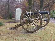
Tipton County Museum
The Tipton County Museum is located in Covington. The museum houses military displays and exhibits from the Civil War history of the county. Taxidermies of local species and mastodonMastodon
Mastodons were large tusked mammal species of the extinct genus Mammut which inhabited Asia, Africa, Europe, North America and Central America from the Oligocene through Pleistocene, 33.9 mya to 11,000 years ago. The American mastodon is the most recent and best known species of the group...
bone fragments give insight into the natural history. Adjacent to the museum, a 20 acres (8 ha) park with a 0.5 miles (804.7 m) long walking trail can be found. Natural woodland and man-made wetlands house a few smaller local species like turtles and birds. The Veterans Memorial in front of the museum commemorates the soldiers from the county who lost their lives in wars. The museum is closed on Sundays and Mondays, admission to the museum and the park is free.
County Parks
Several parks in the county invite visitors to enjoy nature.- Atoka Community Park houses four softball fields. It was built in 1992.
- Court Square Park is s city park with fountains and brick dedication walls.
- Frazier Park is a 10 acres (4 ha) park with a 0.5 miles (804.7 m) fitness trail, playgrounds and ballfields.
- Munford City Park hosts independence festivities every year.
- Patriot Park as opened in 2004. Centerpiece is a A-4 SkyhawkA-4 SkyhawkThe Douglas A-4 Skyhawk is a carrier-capable ground-attack aircraft designed for the United States Navy and United States Marine Corps. The delta winged, single-engined Skyhawk was designed and produced by Douglas Aircraft Company, and later McDonnell Douglas. It was originally designated the A4D...
attack bomber. - Poplar Park offers a covered picnic area, ball fields and a playground.
- Shelton Park is a 1 acre (0.404686 ha) landscaped garden park with gazebo and picnic tables.
- Valentine Regional Park is a family park with picnic pavilion and playgrounds.
Cities and towns
- AtokaAtoka, TennesseeAtoka is a town in Tipton County, Tennessee, United States. The population was 3,235 at the 2000 census. World War I Medal of Honor recipient Joseph B...
- BrightonBrighton, TennesseeBrighton is a town in Tipton County, Tennessee, United States. The population was 1,719 at the 2000 census.-Geography:Brighton is located at ....
- BurlisonBurlison, TennesseeBurlison is a town in Tipton County, Tennessee, United States. The population was 453 at the 2000 census.-Geography:Burlison is located at .According to the United States Census Bureau, the town has a total area of , all of it land....
- CovingtonCovington, TennesseeCovington is a city in central Tipton County in the State of Tennessee. Covington is the largest city and county seat of, Tipton County. Covington is located in one of just five counties of West Tennessee that are located along the Mississippi River, thus it is in extreme western Tennessee.This...
- Drummonds
- GarlandGarland, TennesseeGarland is a town in Tipton County, Tennessee, United States. The population was 309 at the 2000 census.-Geography:Garland is located at .According to the United States Census Bureau, the town has a total area of , all of it land....
- Gilt EdgeGilt Edge, TennesseeGilt Edge is a city in Tipton County, Tennessee, United States. The population was 489 at the 2000 census.-Geography:Gilt Edge is located at ....
- MasonMason, TennesseeMason is a town in Tipton County, Tennessee, United States. The population was 1,089 at the 2000 census. Mason is located along U.S. Highway 70, and is home to a federal detention facility.-Geography:Mason is located at ....
- MunfordMunford, TennesseeMunford is a city in Tipton County, Tennessee, United States. The population was 4,708 at the 2000 census, when it was listed as a town.-Geography:Munford is located at ....
- RandolphRandolph, TennesseeRandolph is an unincorporated rural community in Tipton County, Tennessee, United States, located on the banks of the Mississippi River. Randolph was founded in the 1820s and in 1827, the Randolph Post office was established. In the 1830s, the town became an early center of river commerce in West...
(unincorporated) - ReverieReverie, TennesseeReverie is an unincorporated community in Tipton County, Tennessee, United States. In 2001, the population was 11.Over a period of about 24 hours on March 7, 1876, the Mississippi River abandoned its former channel that coincided with the Tennessee-Arkansas border, and established a new channel...
(unincorporated)
See also
- Island 35 MastodonIsland 35 MastodonThe Island 35 Mastodon was discovered on Island No. 35 of the Mississippi River in Tipton County, Tennessee, United States.In 1900, a Pleistocene mastodon skeleton was excavated approximately 3 mi east of Reverie, Tennessee and 4 mi southeast of Wilson, Arkansas...
- National Register of Historic Places listings in Tipton County, TennesseeNational Register of Historic Places listings in Tipton County, TennesseeThis is a list of the National Register of Historic Places listings in Tipton County, Tennessee.This is intended to be a complete list of the properties and districts on the National Register of Historic Places in Tipton County, Tennessee, United States...
External links
- Tipton County, The Tennessee Encyclopedia of History and Culture