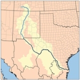
All Topics  
Rio Grande

 
Rio Grande

   Email Print
   Bookmark   Link


Rio Grande


For the railroad often known as the Rio Grande, see Denver and Rio Grande Western Railroad
Denver and Rio Grande Western Railroad

The Denver and Rio Grande Western Railroad , generally referred to as the Rio Grande, originally the Denver and Rio Grande Railroad, is a former U.S....
.


The Rio Grande River in the United States
United States

The United States of America is a Federal government constitutional republic comprising U.S. state and a federal district. The country is situated mostly in central North America, where its Contiguous United States and Washington, D.C., the Capital districts and territories, lie between the Pacific Ocean and Atlantic Oceans, Borders of the U...
, known as the Río Bravo (or, more formally, the Río Bravo del Norte) in Mexico
Mexico

The United Mexican States , commonly known as Mexico , is a federalism constitutionalism republic in North America. It is bordered on the north by the United States; on the south and west by the Pacific Ocean; on the southeast by Guatemala, Belize, and the Caribbean Sea; and on the east by the Gulf of Mexico....
, is a river
River

A river is a natural stream of water, usually freshwater, flowing toward an ocean, a lake, or another stream. In some cases a river flows into the ground or dries up completely before reaching another body of water....
, long, is the fourth longest river system in the United States and serves as a natural boundary along the border between the U.S.


Discussion
Ask a question about 'Rio Grande'
Start a new discussion about 'Rio Grande'
Answer questions from other users
Full Discussion Forum


Encyclopedia


Rio Grande Creede
Sandiamtnnm
Riogrande
Matamoros008
For the railroad often known as the Rio Grande, see Denver and Rio Grande Western Railroad
Denver and Rio Grande Western Railroad

The Denver and Rio Grande Western Railroad , generally referred to as the Rio Grande, originally the Denver and Rio Grande Railroad, is a former U.S....
.


The Rio Grande River in the United States
United States

The United States of America is a Federal government constitutional republic comprising U.S. state and a federal district. The country is situated mostly in central North America, where its Contiguous United States and Washington, D.C., the Capital districts and territories, lie between the Pacific Ocean and Atlantic Oceans, Borders of the U...
, known as the Río Bravo (or, more formally, the Río Bravo del Norte) in Mexico
Mexico

The United Mexican States , commonly known as Mexico , is a federalism constitutionalism republic in North America. It is bordered on the north by the United States; on the south and west by the Pacific Ocean; on the southeast by Guatemala, Belize, and the Caribbean Sea; and on the east by the Gulf of Mexico....
, is a river
River

A river is a natural stream of water, usually freshwater, flowing toward an ocean, a lake, or another stream. In some cases a river flows into the ground or dries up completely before reaching another body of water....
, long, is the fourth longest river system in the United States and serves as a natural boundary along the border between the U.S. state of Texas
Texas

Texas is a U.S. state located in the South Central United States, nicknamed the Lone Star State. Texas is the second largest U.S. state in both area and population, spanning , and with a growing population of 24.3 million residents....
 and the Mexican states of Chihuahua, Coahuila
Coahuila

Coahuila, formally Coahuila de Zaragoza is one of Mexico's 31 component States of Mexico. It is located in the north of the country.To the north, Coahuila accounts for a stretch of the U.S....
, Nuevo León
Nuevo León

Nuevo Le?n is a States of Mexico located in northeastern Mexico. It borders the states of Tamaulipas to the north and east and San Luis Potos? to the south, and Coahuila to the west....
, and Tamaulipas
Tamaulipas

Tamaulipas is one of the 31 States of Mexico of Mexico and is located in the northeast....
.

Description

The Rio Grande rises in the east Rio Grande National Forest
Rio Grande National Forest

Rio Grande National Forest is a 1.86 million acre U.S. National Forest located in southwestern Colorado. The forest encompasses the San Luis Valley, which is the world's largest agriculture :wikt:alpine valley....
 in the U.S. state of Colorado
Colorado

The State of Colorado is a U.S. state located in the Mountain States of the United States of America. Colorado may also be considered to be a part of the Western United States and Southwestern United States regions of the United States....
. It is formed by the joining of several streams at the base of Canby Mountain, just east of the continental divide
Continental Divide

The Continental Divide of the Americas, or merely the Continental Divide or Great Divide, is the name given to the principal, and largely mountainous, hydrological divide of the Americas that separates the drainage basin that drain into the Pacific Ocean from, 1) those river systems which drain into the Atlantic Ocean , and 2)...
. From there, it flows through the San Luis Valley
San Luis Valley

The San Luis Valley is an extensive alpine valley in the US states of Colorado and New Mexico covering approximately and sitting at an average elevation of above sea level....
, then south into New Mexico
New Mexico

New Mexico is a U. S. State located in the Southwestern United States of the United States. Inhabited by Native Americans in the United States populations for many centuries, it has also has been part of the Spanish Empire viceroyalty of New Spain, part of Mexico, and a U.S....
 through Albuquerque
Albuquerque, New Mexico

Albuquerque is the largest List of cities in the United States in the US state of New Mexico, United States. It is the county seat of Bernalillo County, New Mexico and is situated in the central part of the state, straddling the Rio Grande....
 and Las Cruces
Las Cruces, New Mexico

Las Cruces is a city in Do?a Ana County, New Mexico, New Mexico, United States. As of the 2000 United States Census, the city had a total population of 74,267....
 to El Paso
El Paso, Texas

El Paso is a city in and the county seat of El Paso County, Texas, Texas, United States, and part of the . According to the United States Census Bureau 2006 population estimates, the city had a population of 606,913....
, Texas
Texas

Texas is a U.S. state located in the South Central United States, nicknamed the Lone Star State. Texas is the second largest U.S. state in both area and population, spanning , and with a growing population of 24.3 million residents....
, where it begins to form the border
Natural border

A natural border is a border between states which is composed of natural formations such as rivers, mountain ranges, or deserts.Having a natural border is strategy very useful, as invading army have a hard time crossing such a border....
 between the U.S. and Mexico
United States–Mexico border

The Mexico ? United States border is the international border between Mexico and the United States. It runs from San Diego, California, and Tijuana, Baja California, in the west to Matamoros, Tamaulipas, Tamaulipas, and Brownsville, Texas, Texas, in the east, and traverses a variety of terrains, ranging from major urban areas to inhospitabl...
. A major tributary, the Río Conchos, enters at Ojinaga, Chihuahua, below El Paso, and supplies most of the water in the Texas border segment. Other known tributaries include the Pecos
Pecos River

The Pecos River or Rio Pecos, as it is sometimes known in New Mexico, arises near Pecos, New Mexico, United States, and flows for through the eastern portion of that state and neighboring Texas before it empties into the Rio Grande near Del Rio, Texas....
 and the smaller Devils
Devils River (Texas)

The Devils River is a pristine, whitewater river in southwestern Texas, USA. From its headwaters in northwest Sutton County, it flows southwest for through Val Verde County, Texas and empties into the northeastern shore of the Lake Amistad in Del Rio, Texas on the Texas/Mexico border....
, which join the Rio Grande on the site of Amistad Dam
Amistad Reservoir

Amistad Reservoir is a Reservoir on the Rio Grande at its confluence with the Devils River 12 miles northwest of Del Rio, Texas, Texas, USA....
. Despite its name and length, the Rio Grande is not navigable by oceangoing ships, nor are there smaller craft using it as a route. In fact it is barely navigable at all. Its natural flow is only 1/20 the volume of the Colorado River, and less than 1/100 that of the Mississippi.

The river has, since 1848, marked the boundary between Mexico and the United States from the twin cities of El Paso, Texas
El Paso, Texas

El Paso is a city in and the county seat of El Paso County, Texas, Texas, United States, and part of the . According to the United States Census Bureau 2006 population estimates, the city had a population of 606,913....
, and Ciudad Juárez, Chihuahua
Ciudad Juárez

Ciudad Ju?rez, also known as just Ju?rez and formerly known as El Paso del Norte, is a city and seat of the Ju?rez in the Mexican state of Chihuahua ....
, to the Gulf of Mexico
Gulf of Mexico

The Gulf of Mexico is the ninth largest body of water in the world. Considered a smaller part of the Atlantic Ocean, it is an oceanic basin largely surrounded by the North American continent and the island of Cuba....
. As such, it was across this river that Texan slaves fled when seeking their freedom, aided by Mexico's liberal colonization policies and abolitionist stance.

The major international border crossings along the river are Ciudad Juárez and El Paso; Presidio, Texas
Presidio, Texas

Presidio is a city in Presidio County, Texas, Texas, United States. It stands on the Rio Grande , on the other side of the U.S.-Mexico border from Ojinaga, Chihuahua....
, and Ojinaga, Chihuahua; Laredo, Texas
Laredo, Texas

Laredo is the county seat of Webb County, Texas, Texas, United States, located on the north bank of the Rio Grande in South Texas, across from Nuevo Laredo, Tamaulipas, Mexico....
, and Nuevo Laredo, Tamaulipas
Nuevo Laredo

Nuevo Laredo is a city located in the Municipality of Nuevo Laredo in the States of Mexico of Tamaulipas. The city lies on the banks of the R?o Grande, across from the United States city of Laredo, Texas....
; McAllen-Hidalgo, Texas
McAllen, Texas

McAllen is the largest city in Hidalgo County, Texas, Texas, United States. It is located at the southern tip of Texas in an area known as the Rio Grande Valley and is part of the Southwestern United States....
, and Reynosa, Tamaulipas
Reynosa

Reynosa is a city in the Mexican state of Tamaulipas. It is located at , across the Rio Grande from McAllen, Texas in the U.S. state of Texas. According to INEGI census 2005 Reynosa's population was 507,998 for the city and 526,888 for the municipality....
; and Brownsville, Texas
Brownsville, Texas

Brownsville is a city in and the county seat of Cameron County, Texas, Texas, United States. Brownsville is the 15th largest city in the state of Texas and the 130th largest in the United States....
, and Matamoros, Tamaulipas
Matamoros, Tamaulipas

Matamoros, formally Heroica Matamoros, is a city in the northeast of the States of Mexico of Tamaulipas. It is located at , across the Rio Grande from the U.S....
. Other notable border towns are the Texas
Texas

Texas is a U.S. state located in the South Central United States, nicknamed the Lone Star State. Texas is the second largest U.S. state in both area and population, spanning , and with a growing population of 24.3 million residents....
/Coahuila
Coahuila

Coahuila, formally Coahuila de Zaragoza is one of Mexico's 31 component States of Mexico. It is located in the north of the country.To the north, Coahuila accounts for a stretch of the U.S....
 pairings of Del Rio
Del Rio, Texas

Del Rio is a border city in and the county seat of Val Verde County, Texas, Texas, United States.. Del Rio is connected with Ciudad Acu?a via the Lake Amistad Dam International Crossing and Del R?o-Ciudad Acu?a International Bridge....
Ciudad Acuña
Ciudad Acuña

Ciudad Acu?a, also known simply as Acu?a, is a city located in the Mexico Mexican state of Coahuila, at and a mean height above sea level of 280 meters....
 and Eagle Pass
Eagle Pass, Texas

Eagle Pass is a city in and the county seat of Maverick County, Texas, Texas, United States. The population was 22,413 at the 2000 United States Census....
Piedras Negras
Piedras Negras, Coahuila

Piedras Negras is a city and seat of the Piedras Negras in the Mexico States of Mexico of Coahuila. It stands at the northeastern edge of Coahuila on the U.S.-Mexico border, across the Rio Grande from Eagle Pass, Texas in the U.S....
.

The US and Mexico
Mexico

The United Mexican States , commonly known as Mexico , is a federalism constitutionalism republic in North America. It is bordered on the north by the United States; on the south and west by the Pacific Ocean; on the southeast by Guatemala, Belize, and the Caribbean Sea; and on the east by the Gulf of Mexico....
 share the waters of this river under a series of agreements administered by the joint US-Mexico Boundary and Water Commission. The most notable of these were signed in 1906 and 1944.

Use of that belonging to the US is regulated by the Rio Grande Compact
Rio Grande Compact

The Rio Grande Compact is a treaty signed in 1938 in the United States between the states of Colorado, New Mexico, and Texas, and approved by the United States Congress, to equitably apportion the waters of the Rio Grande Basin....
, an interstate pact between Colorado
Colorado

The State of Colorado is a U.S. state located in the Mountain States of the United States of America. Colorado may also be considered to be a part of the Western United States and Southwestern United States regions of the United States....
, New Mexico
New Mexico

New Mexico is a U. S. State located in the Southwestern United States of the United States. Inhabited by Native Americans in the United States populations for many centuries, it has also has been part of the Spanish Empire viceroyalty of New Spain, part of Mexico, and a U.S....
 and Texas
Texas

Texas is a U.S. state located in the South Central United States, nicknamed the Lone Star State. Texas is the second largest U.S. state in both area and population, spanning , and with a growing population of 24.3 million residents....
. The Rio Grande is over-appropriated, that is, there are more users for the water than there is water in the river. Because of both drought and overuse the section from El Paso downstream through Ojinaga
Ojinaga

Ojinaga is one of the 67 municipalities of Chihuahua, in northern Mexico. The municipal seat lies at Ojinaga , a rural bordertown on the U.S.-Mexico border....
 was recently tagged "The Forgotten River" by those wishing to bring attention to the river's deteriorated condition.

In the summer of 2001 a 100 m wide sandbar formed at the mouth of the river, marking the first time in recorded history that the Rio Grande failed to empty into the Gulf of Mexico. The sandbar was subsequently dredged, but it re-formed almost immediately. Spring rains the following year flushed the re-formed sandbar out to sea, but it returned in the summer of 2002. As of September 2006, the river once again reaches the Gulf. However, ecologists fear that unless rainfall returns to normal levels during the next few years and strict water conservation measures are adopted by communities along the river, the Rio Grande may soon become extinct.

The Rio Grande rises in high mountains and flows for much of its length at high elevation; El Paso is above sea level
Sea level

Mean sea level is the average height of the sea, with reference to a suitable reference surface. Defining the reference level , however, involves complex measurement, and accurately determining MSL can prove difficult....
. In New Mexico, the river flows through the Rio Grande Rift
Rio Grande Rift

The Rio Grande rift is a rift valley extending north from Mexico, near El Paso, Texas through New Mexico into central Colorado. The upper Rio Grande flows south down the rift valley, but did not incise the rift valley....
 from one sediment
Sediment

Sediment is any particulate matter that can be sediment transport by fluid dynamics, and which eventually is deposited.Sediments are most often transported by water transported by wind and glaciers....
-filled basin to another, cutting canyon
Canyon

A canyon, or gorge, is a deep valley between cliffs often carved from the landscape by a river. Most canyons were formed by a process of long-time erosion from a plateau level....
s between the basins and supporting a fragile bosque
Bosque

Bosque is the name for areas of gallery forest found along the flood plains of stream and river banks in the southwestern United States. It derives its name from the Spanish language word for wikt:bosque....
 ecosystem in its floodplain
Floodplain

||-||-||-||-||-||-||-||}A floodplain, or flood plain, is flat or nearly flat land adjacent to a stream or river that experiences occasional or periodic flooding....
. From El Paso eastward the river flows through desert
Désert

?D?sert? is ?milie Simon's debut single, released in October 2002. The song was a huge success both critically and commercially in her homeland....
. Only in the sub-tropical lower Rio Grande Valley
Rio Grande Valley

The Rio Grande Valley is an area located in the southernmost tip of South Texas. It lies along the northern bank of the Rio Grande, which separates Mexico from the United States....
 is there extensive irrigated agriculture. The river ends in a small sand
Sand

Sand is a naturally occurring granular material composed of finely divided rock and mineral particles.As the term is used by geologists, sand particles range in diameter from 0.0625 to 2 millimeters....
y delta
River delta

A delta is a landform that is created at the mouth of a river where that river flows into an ocean, sea, estuary, lake, reservoir, flat arid area, or another river....
 at the Gulf of Mexico
Gulf of Mexico

The Gulf of Mexico is the ninth largest body of water in the world. Considered a smaller part of the Atlantic Ocean, it is an oceanic basin largely surrounded by the North American continent and the island of Cuba....
. Due to the persistent period of dry weather, the river has only occasionally emptied into the Gulf Of Mexico since 2002.

Millions of years ago, the Rio Grande ended at the bottom of the Rio Grande Rift in Lake Cabeza de Vaca. But about one million years ago
Mya (unit)

In astronomy, geology, and paleontology, mya or "m.y.a." is an abbreviation for "million years ago". Like the related unit bya, mya is traditionally written in lower case....
 the stream was "captured" and began to flow east.

The Rio Grande was designated as one of the American Heritage Rivers
American Heritage Rivers

American Heritage Rivers are designated bythe United States Environmental Protection Agency to receive special attention to further three objectives: natural resource and environmental protection, economic revitalization, and historic and cultural preservation....
 in 1997.

Names and pronunciation

is Spanish
Spanish language

Spanish or Castilian is a Romance languages that originated in northern Spain, and gradually spread in the Kingdom of Castile and evolved into the principal language of government and trade....
 for "Big River" and means "Great River of the North". In English
English language

English is a West Germanic language that originated in Anglo-Saxon England and has lingua franca status in many parts of the world as a result of the military, economic, scientific, political and cultural influence of the British Empire in the 18th, 19th and early 20th centuries and that of the United States from the mid 20th century onwa...
, Rio Grande is pronounced either or . Because "río" means "river" in Spanish, the phrase "Rio Grande River" is redundant.

In Mexico it is known as Río Bravo or , "" meaning "fierce" or "brave". There is a city along its banks that bears its name (Río Bravo, Tamaulipas
Río Bravo, Tamaulipas

R?o Bravo formally Ciudad R?o Bravo is a city in northern part of the Mexican state of Tamaulipas. It is the municipal seat of R?o Bravo municipalities of Mexico....
) located 10 miles east of Reynosa, Tamaulipas, and directly across from the Texas city of Donna
Donna, Texas

Donna is a city in Hidalgo County, Texas, Texas, United States. The population was 14,768 at the 2000 United States Census. The city's motto is "The City with a Heart in the Heart of the Rio Grande Valley"....
.

Historically, the Rio Grande/Rio Bravo has been called:
  • mets'ichi chena, Keresan, "Big River"
  • posoge, Tewa
    Tewa language

    Tewa is a Kiowa-Tanoan language spoken by Pueblo people, mostly in the Rio Grande valley in New Mexico north of Santa Fe, New Mexico. The 1980 census counted 1,298 speakers, almost all of whom are bilingual in English....
    , "Big River"
  • paslápaane, Tiwa
    Tiwa languages

    Tiwa is a group of two, possibly three, related Kiowa-Tanoan languages spoken by the Tiwa people Puebloan peoples, and possibly Piro Pueblo, groups in the United States state of New Mexico....
    , "Big River"
  • , Towa
    Jemez language

    Jemez is a Kiowa-Tanoan language spoken by the Jemez Pueblo people in New Mexico. It has no written form, as tribal rules do not allow it....
    , "Great Waters"
  • , Navajo
    Navajo language

    Navajo or Navaho is an Athabaskan languages spoken in the southwest United States by the Navajo people . It is geographically and linguistically one of the Southern Athabaskan languages ....
    , "Female River" (the direction south is female in Navajo cosmology)


Rio del Norte was the most common name for the upper Rio Grande (roughly, within the present-day borders of New Mexico) from Spanish colonial times to the end of the Mexican period in the mid-19th century. Its use was first documented in 1582. The use of the modern English name Rio Grande began with the early American settlers in [south Texas]. By the late 19th century, the name Rio Grande for the entire river, from [Colorado] to the sea, had become standard in the United States.

Rio Bravo had become the standard Spanish name for the lower river, below its confluence with the Rio Conchos, by 1602.

Note that the four [Pueblo] names probably predate the Spanish entrada
History of New Mexico

Evidence from archaeologists conveys the existence of natives back to approximately 9,200 BC. However, the History of New Mexico was not officially recorded until the arriving of the Conquistadors, who encountered Native American Pueblos when they explored the area in the 1500s....
 by several centuries.

Literature

  • Paul Horgan, Great River: The Rio Grande in North American History. Volume 1, Indians and Spain. Vol. 2, Mexico and the United States. 2 Vols. in 1, 1038 pages - Wesleyan University Press 1991, 4th Reprint, ISBN 0-8195-6251-3


See also

  • Rio Bravo, Texas
    Rio Bravo, Texas

    Rio Bravo is a city in Webb County, Texas, Texas, United States. The population was 5,553 at the 2000 United States Census. The city is the second largest in Webb County....
  • US-Mexico Border
  • Rio Grande border disputes
    Rio Grande border disputes

    The Rio Grande has changed course several times in recorded history, leading to a number of border disputes, both international and between individual U.S....
  • List of crossings of the Rio Grande
    List of crossings of the Rio Grande

    This is a list of bridges and other crossings of the Rio Grande from the Gulf of Mexico upstream to its source....
  • List of Colorado rivers
    List of Colorado rivers

    Lists of rivers and streams in the U.S. State of Colorado....
  • List of New Mexico rivers
    List of New Mexico rivers

    This is a list of rivers in the U.S. state of New Mexico arranged by drainage basin, with respective tributaries indented under each larger stream's name....
  • List of Texas rivers
    List of Texas rivers

    This is a list of the rivers in the state of Texas in the United States....
  • Rio Grande Wild and Scenic River
    Rio Grande Wild and Scenic River

    The Rio Grande Wild and Scenic River protects a 196 mile portion of the Rio Grande in Texas. Parts of Brewster County, Texas, Terrell County, Texas, and Val Verde County, Texas counties are included in this section of the river....
  • Rio Grande Valley
    Rio Grande Valley

    The Rio Grande Valley is an area located in the southernmost tip of South Texas. It lies along the northern bank of the Rio Grande, which separates Mexico from the United States....
  • Rio Grande Gorge
    Rio Grande Gorge

    The Rio Grande Gorge runs from northwest to southeast of Taos, New Mexico, New Mexico, through the basalt flows of the Taos Plateau volcanic field....
  • Rio Grande Trail
    Rio Grande Trail

    The Rio Grande Trail is a proposed long distance trail along the Rio Grande in the U.S. state of New Mexico. The river extends over 1,800 total miles, some of which pass though the heart of New Mexico....


External links

  • (hosted by the ).
  • Peace Palace Library


need to be created first