

Saint Anthony Falls
Encyclopedia
Saint Anthony Falls, or the Falls of Saint Anthony, located northeast of downtown Minneapolis, Minnesota
, was the only natural major waterfall
on the Upper
Mississippi River
. The natural falls was replaced by a concrete overflow spillway (also called an "apron") after it partially collapsed in 1869. Later, in the 1950s and 1960s, a series of locks and dam
s were constructed to extend navigation to points upstream.
Named after the Catholic saint Anthony of Padua
, the falls is the birthplace of the former city of St. Anthony
and to Minneapolis when the two cities joined in 1872 to fully use its economic power for milling operations. From 1880 to about 1930, Minneapolis was the "Flour Milling Capital of the World."
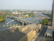
Today, the falls is defined by the Lower Saint Anthony Falls which refers to a downstream lock of what is now officially referred to as Upper Saint Anthony Falls. These locks were built as part of the Upper Mississippi River 9-Foot Navigation Project. The area around the falls is designated the St. Anthony Falls Historic District.
 Before European exploration, the falls held cultural and political significance for native tribes who frequented the area. The falls was an important and sacred site to the Mdewakanton
Dakota
and they called the Mississippi River, hahawakpa, "river of the falls." The falls (haha) themselves were given specific names, mnirara "curling waters," owahmenah "falling waters," or owamni, "whirlpool" (mniyomni in the Eastern Dakota dialect and owamniyomni in the Teton Dakota (Lakota
) dialect. Dakota associated the falls with legends and spirits, including Oanktehi, god of waters and evil, who lived beneath the falling water. The sacred falls also enters into their oral tradition by a story of a warrior's first wife who killed herself and their two children in anguish and forlorn love for the husband who had assumed a second wife. The rocky islet where the woman had pointed her canoe towards doom thus was named Spirit Island which was once a nesting ground for eagles that fed on fish below the falls. Dakota also camped on Nicollet Island upstream of the falls to fish and to tap the sugar maple trees.
 Since the cataract had to be portaged, the area became one of the natural resting and trade points along the Mississippi between Dakota and Anishinaabe peoples. The Anishinaabe (Ojibwe) term was recorded as "kakabikah" (gakaabikaa, "split rock" or more descriptively, gichi-gakaabikaa, "the great severed rock" which referenced the jagged chunks of limestone constantly eroding by the falls).
In 1680, the falls became known to the Western world when they were observed and published in a journal by Father Louis Hennepin
, a Catholic friar of Belgian birth, who also first published about Niagara Falls
to the world's attention. Hennepin named them the Chutes de Saint-Antoine or the Falls of Saint Anthony after his patron saint, Anthony of Padua
. Later explorers to document the falls include Jonathan Carver
and Zebulon Montgomery Pike.
 Following the establishment of Fort Snelling in 1820, the falls became an attraction for tourists, writers and artists who sought inspiration even if Hennepin's descriptions were not as majestic as hoped for. By the 1860s, however, industrial waste had filled the area and marred the falls' majesty. Further competition over the power of the falls on both banks of the river led to its eventual downfall when it partially collapsed in 1869 and was reinforced and subsequently sealed by a concrete overflow spillway (or "apron").
The area around the falls was added to the National Register of Historic Places
as the Saint Anthony Falls Historic District in 1971 which includes 8th Avenue Northeast extending downstream to 6th Avenue Southeast and approximately two city blocks on both shoreline. The district's archaeological record is one of the most-endangered historic sites in Minnesota. The National Register of Historic Places is facilitated by the National Park Service
. The national significance of the Saint Anthony Falls Historic District is a major reason why the National Park Service's Mississippi National River and Recreation Area
was established along the Mississippi River in the Minneapolis – Saint Paul metropolitan area.
A Heritage Trail plaque nearby says,
 Geologists
say that the falls first appeared roughly 10,000 years ago several miles downstream at the confluence of the glacial River Warren
(at present-day Ft. Snelling). Estimates are that the falls were about 180 feet (54.9 m) high when the River Warren Falls
receded past the confluence of the Mississippi River and the glacial River Warren. Over the succeeding 10,000 years, the falls moved upstream to its present location, breaking off the limestone cap in chunks as it receded. Tributaries such as Minnehaha Creek begot their own waterfalls as the Mississippi River valley was cut into the landscape.
From its origins near Fort Snelling, St. Anthony Falls relocated upstream at a rate of about 4 feet (1.2 m) per year until it reached its present location in the early 19th century. When Father Louis Hennepin documented the falls he estimated the falls' height to be 50 or 60 feet (18.3 m). Later explorers described it as being in the range of 16 to 20 feet (6.1 m) high. The discrepancy may have been due to scope, as the current total drop in river level over the series of dams is 76 ft (23 m).
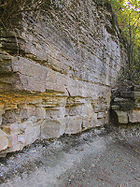
The geological formation of the area consisted of a hard, thin layer of Platteville Formation
, a carbonate rock
, overlaying the soft St. Peter Sandstone
sub-surface. These layers were the result of an Ordovician Period sea which covered east-central Minnesota 500 million years ago. The water churning at the bottom of the falls ate away at the sandstone, and after enough support had been removed, large blocks of the Platteville Formation would fall off. This process had been happening naturally since 8000 BC, with the falls having receded up from the Fort Snelling area to their location in the 1850s.
 The first private land claim at the falls was made by Franklin Steele
in 1838 — though he didn't obtain financing for development until 1847, in the form of $12,000 for a 9/10 stake in the property. On May 18, 1848 president Polk
approved the claims made in St. Anthony, and Steele was able to build his dam on the east side of the river above the Falls, blocking the east channel.
The dam extended diagonally into the river 700 feet (213.4 m), was 16 feet (4.9 m) high, and was secured to the limestone riverbed. Its thickness tapered from 40 wide at its base to 12 feet (3.7 m) wide at the top. Steele dispatched logging crews to the Crow Wing River
in December 1847 to supply pine for the sawmill
, and by September 1, 1848 sawing commenced using two up-down saws. He was able to sell the lumber readily, supplying construction projects in the booming town. The new community at the Falls attracted entrepreneurs from New England
, many of whom had experience in lumber and milling. He had hired Ard Godfrey to help build and run the first commercial sawmill at the Falls. Godfrey knew the most efficient ways to use natural resources, like the falls, and the great pine forests, to make lumber products. Godfrey built the first home in St. Anthony, Steele had the town platted in 1849, and it incorporated in 1855.
By 1854, 300 squatters occupied the west bank of the river, and in 1855 Congress recognized the squatters' right to purchase the land they had claimed. The west side quickly developed scores of new mills and consortia. They built a dam diagonally into the river to the north, which, along with Steele's dam created the inverted V-shape, still apparent today. Steele created the St. Anthony Falls Water Power Company in 1856 with three New York
financiers. The company struggled for several years, due to poor relations with the financiers, a depression, and the Civil War. In 1868 the firm reorganized with new officers including John Pillsbury
, Richard and Samuel Chute, Sumner Farnham, and Frederick Butterfield.
 As Minneapolis (and its former neighbor across the river, St. Anthony) developed, the water power
at the falls became a source of power for several industries. Water power was used by sawmill
s, textile mills, and flour mills. Millers on the Minneapolis side formed a consortium to extract power by diverting upper-level water into waterwheel-equipped vertical shafts (driven through the limestone
bedrock into the soft, underlying sandstone
) and then through horizontal tunnels to the falls' lower level. These shafts and tunnels weakened the limestone and its sandstone foundation, accelerating the falls' upriver erosion to 26 feet (7.9 m) per year between 1857 and 1868. The falls quickly approached the edge of their limestone cap; once the limestone had completely eroded away, the falls would degenerate into sandstone rapids unsuitable for waterpower. The mills on the St. Anthony (east) side of the river were less-well organized harnessing the power, and therefore industry developed at a slower pace on that side.
 The early dams built to harness the waterpower exposed the limestone to freezing and thawing forces, narrowed the channel, and increased the damage from floods. A report in 1868 found that only eleven hundred feet of the limestone remained upstream, and if it were eroded away, the falls would turn into a rapids that would no longer be useful for waterpower. Meanwhile, the St. Anthony Falls Water Power Company approved a plan for the firm of William W. Eastman and John L. Merriam to build a tunnel under Hennepin and Nicollet Islands that would share the waterpower. This plan was met with disaster on October 5, 1869, when the limestone cap was breached.
The leak turned into a torrent of water coming out the tunnel. The water blasted Hennepin Island, causing a 150 feet (45.7 m) chunk to fall off into the river. Believing that the mills and all the other industries around the falls would be ruined, hundreds of people rushed to view the impending disaster. Groups of volunteers started shoring up the gap by throwing trees and timber into the river, but that was ineffective. They then built a huge raft of timbers from the milling operations on Nicollet Island. This worked briefly, but also proved ineffective. A number of workers worked for months to build a dam that would funnel water away from the tunnel. The next year, an engineer from Lowell, Massachusetts
recommended completing a wooden apron, sealing the tunnel, and building low dams above the falls to avoid exposing the limestone to the weather. This work was assisted by the federal government, and was eventually completed in 1884. The federal government spent $615,000 on this effort, while the two cities spent $334,500.
 St. Anthony Falls was the upper limit of commercial navigation on the Mississippi until two dams and a series of locks were built between 1948 and 1963 by the United States Army Corps of Engineers
. The locks make commercial navigation possible above Minneapolis but, since the locks in Minneapolis are smaller than most of the locks on the river, the practical limit for many commercial tows is further downriver. Few barges go past St. Paul
.
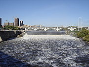
 Completed in 1963, the upper St. Anthony Falls dam is a horseshoe-shaped hydro-electric
dam
93 feet (28 m) in height. The upper pool has a normal capacity of 3150 acre.ft and a normal level of 799 feet (244 m) above sea level
. The navigation channel required alteration of the historic Stone Arch Bridge, which now has a metal truss section to allow ships to pass below.
Completed in 1956, the lower St. Anthony Falls dam is a gravity-type hydro-electric dam 60 feet (18 m) in height, consisting of a 275 foot (84 m) long concrete spillway with 4 tainter gate
s. The lower pool (sometimes called the intermediate pool) has a normal capacity of 375 acre.ft and a normal level of 750 feet (229 m) above sea level.
 The pool below the lower dam has a normal level of 725 feet (221 m) above sea level.
The upper and lower locks are each 56 feet (17 m) wide by 400 feet (122 m) long.
The current around the spillway/falls is often swift and dangerous. In 1991, a small boat drifted too close and fell over one part of the dam. Two people onboard were killed, and two others had to be rescued by helicopter
. Rescues at the site are usually much less dramatic, but continue to happen occasionally.
Minnesota
Minnesota is a U.S. state located in the Midwestern United States. The twelfth largest state of the U.S., it is the twenty-first most populous, with 5.3 million residents. Minnesota was carved out of the eastern half of the Minnesota Territory and admitted to the Union as the thirty-second state...
, was the only natural major waterfall
Waterfall
A waterfall is a place where flowing water rapidly drops in elevation as it flows over a steep region or a cliff.-Formation:Waterfalls are commonly formed when a river is young. At these times the channel is often narrow and deep. When the river courses over resistant bedrock, erosion happens...
on the Upper
Upper Mississippi River
The Upper Mississippi River is the portion of the Mississippi River upstream of Cairo, Illinois, United States. From the headwaters at Lake Itasca, Minnesota, the river flows approximately 2000 kilometers to Cairo, where it is joined by the Ohio River to form the Lower Mississippi...
Mississippi River
Mississippi River
The Mississippi River is the largest river system in North America. Flowing entirely in the United States, this river rises in western Minnesota and meanders slowly southwards for to the Mississippi River Delta at the Gulf of Mexico. With its many tributaries, the Mississippi's watershed drains...
. The natural falls was replaced by a concrete overflow spillway (also called an "apron") after it partially collapsed in 1869. Later, in the 1950s and 1960s, a series of locks and dam
Dam
A dam is a barrier that impounds water or underground streams. Dams generally serve the primary purpose of retaining water, while other structures such as floodgates or levees are used to manage or prevent water flow into specific land regions. Hydropower and pumped-storage hydroelectricity are...
s were constructed to extend navigation to points upstream.
Named after the Catholic saint Anthony of Padua
Anthony of Padua
Anthony of Padua or Anthony of Lisbon, O.F.M., was a Portuguese Catholic priest and friar of the Franciscan Order. Though he died in Padua, Italy, he was born to a wealthy family in Lisbon, Portugal, which is where he was raised...
, the falls is the birthplace of the former city of St. Anthony
St. Anthony, Minnesota
St. Anthony is the name of more than one place in the U.S. state of Minnesota:*St. Anthony, Stearns County, Minnesota*St. Anthony, Hennepin County, Minnesota-See also:*Saint Anthony Park , a neighborhood in Saint Paul, Minnesota...
and to Minneapolis when the two cities joined in 1872 to fully use its economic power for milling operations. From 1880 to about 1930, Minneapolis was the "Flour Milling Capital of the World."
Today, the falls is defined by the Lower Saint Anthony Falls which refers to a downstream lock of what is now officially referred to as Upper Saint Anthony Falls. These locks were built as part of the Upper Mississippi River 9-Foot Navigation Project. The area around the falls is designated the St. Anthony Falls Historic District.
History
Mdewakanton
Mdewakantonwan are one of the sub-tribes of the Isanti Dakota . Their historic home is Mille Lacs Lake in central Minnesota, which in the Dakota language was called mde wakan .As part of the Santee Sioux, their ancestors had migrated from the Southeast of the present-day United States, where the...
Dakota
Sioux
The Sioux are Native American and First Nations people in North America. The term can refer to any ethnic group within the Great Sioux Nation or any of the nation's many language dialects...
and they called the Mississippi River, hahawakpa, "river of the falls." The falls (haha) themselves were given specific names, mnirara "curling waters," owahmenah "falling waters," or owamni, "whirlpool" (mniyomni in the Eastern Dakota dialect and owamniyomni in the Teton Dakota (Lakota
Lakota language
Lakota is a Siouan language spoken by the Lakota people of the Sioux tribes. While generally taught and considered by speakers as a separate language, Lakota is mutually understandable with the other two languages , and is considered by most linguists one of the three major varieties of the Sioux...
) dialect. Dakota associated the falls with legends and spirits, including Oanktehi, god of waters and evil, who lived beneath the falling water. The sacred falls also enters into their oral tradition by a story of a warrior's first wife who killed herself and their two children in anguish and forlorn love for the husband who had assumed a second wife. The rocky islet where the woman had pointed her canoe towards doom thus was named Spirit Island which was once a nesting ground for eagles that fed on fish below the falls. Dakota also camped on Nicollet Island upstream of the falls to fish and to tap the sugar maple trees.
In 1680, the falls became known to the Western world when they were observed and published in a journal by Father Louis Hennepin
Louis Hennepin
Father Louis Hennepin, O.F.M. baptized Antoine, was a Catholic priest and missionary of the Franciscan Recollect order and an explorer of the interior of North America....
, a Catholic friar of Belgian birth, who also first published about Niagara Falls
Niagara Falls
The Niagara Falls, located on the Niagara River draining Lake Erie into Lake Ontario, is the collective name for the Horseshoe Falls and the adjacent American Falls along with the comparatively small Bridal Veil Falls, which combined form the highest flow rate of any waterfalls in the world and has...
to the world's attention. Hennepin named them the Chutes de Saint-Antoine or the Falls of Saint Anthony after his patron saint, Anthony of Padua
Anthony of Padua
Anthony of Padua or Anthony of Lisbon, O.F.M., was a Portuguese Catholic priest and friar of the Franciscan Order. Though he died in Padua, Italy, he was born to a wealthy family in Lisbon, Portugal, which is where he was raised...
. Later explorers to document the falls include Jonathan Carver
Jonathan Carver
Jonathan Carver was an American explorer and writer. He was born in Weymouth, Massachusetts and then moved with his family to Canterbury, Connecticut. He later married Abigail Robbins and became a shoemaker. He is believed to have had seven children.In 1755 Carver joined the colonial militia at...
and Zebulon Montgomery Pike.
The area around the falls was added to the National Register of Historic Places
National Register of Historic Places
The National Register of Historic Places is the United States government's official list of districts, sites, buildings, structures, and objects deemed worthy of preservation...
as the Saint Anthony Falls Historic District in 1971 which includes 8th Avenue Northeast extending downstream to 6th Avenue Southeast and approximately two city blocks on both shoreline. The district's archaeological record is one of the most-endangered historic sites in Minnesota. The National Register of Historic Places is facilitated by the National Park Service
National Park Service
The National Park Service is the U.S. federal agency that manages all national parks, many national monuments, and other conservation and historical properties with various title designations...
. The national significance of the Saint Anthony Falls Historic District is a major reason why the National Park Service's Mississippi National River and Recreation Area
Mississippi National River and Recreation Area
The Mississippi National River and Recreation Area protects a and corridor along the Mississippi River from the cities of Dayton and Ramsey, Minnesota to just downstream of Hastings, Minnesota. This includes the stretch of Mississippi River which flows through Minneapolis and St. Paul, Minnesota...
was established along the Mississippi River in the Minneapolis – Saint Paul metropolitan area.
A Heritage Trail plaque nearby says,
"For untold generations of Indian people the Mississippi River was an important canoe route. To pass around the falls, the Dakota (SiouxSiouxThe Sioux are Native American and First Nations people in North America. The term can refer to any ethnic group within the Great Sioux Nation or any of the nation's many language dialects...
) and Ojibway (Chippewa) used a well-established portage trail. Starting at a landing below the site now occupied by the steam plantSoutheast Steam PlantThe Southeast Steam Plant, also known as the Twin City Rapid Transit Company Steam Power Plant, is a combined heat and power plant on the Mississippi River in the city of Minneapolis, Minnesota in the United States owned by the University of Minnesota....
, the trail climbed the bluff to this spot. From here it followed the east bank along what is now Main Street to a point well above the falls."
Geology
Geology
Geology is the science comprising the study of solid Earth, the rocks of which it is composed, and the processes by which it evolves. Geology gives insight into the history of the Earth, as it provides the primary evidence for plate tectonics, the evolutionary history of life, and past climates...
say that the falls first appeared roughly 10,000 years ago several miles downstream at the confluence of the glacial River Warren
Glacial River Warren
right|thumb|210px|The course of the Minnesota River follows the valley carved by Glacial River WarrenGlacial River Warren or River Warren was a prehistoric river that drained Lake Agassiz in central North America between 11,700 and 9,400 years ago...
(at present-day Ft. Snelling). Estimates are that the falls were about 180 feet (54.9 m) high when the River Warren Falls
River Warren Falls
The River Warren Falls was a massive waterfall on the glacial River Warren initially located in present-day Saint Paul, Minnesota, United States. The waterfall was 2700 feet across and 175 feet high.-Geologic history:...
receded past the confluence of the Mississippi River and the glacial River Warren. Over the succeeding 10,000 years, the falls moved upstream to its present location, breaking off the limestone cap in chunks as it receded. Tributaries such as Minnehaha Creek begot their own waterfalls as the Mississippi River valley was cut into the landscape.
From its origins near Fort Snelling, St. Anthony Falls relocated upstream at a rate of about 4 feet (1.2 m) per year until it reached its present location in the early 19th century. When Father Louis Hennepin documented the falls he estimated the falls' height to be 50 or 60 feet (18.3 m). Later explorers described it as being in the range of 16 to 20 feet (6.1 m) high. The discrepancy may have been due to scope, as the current total drop in river level over the series of dams is 76 ft (23 m).
The geological formation of the area consisted of a hard, thin layer of Platteville Formation
Platteville Limestone
The Platteville Limestone is the Ordivician limestone formation in the sedimentary sequence characteristic of the upper Midwestern United States. It overlies the thin Glenwood Shale, which overlies the thick Saint Peter Sandstone...
, a carbonate rock
Carbonate rock
Carbonate rocks are a class of sedimentary rocks composed primarily of carbonate minerals. The two major types are limestone, which is composed of calcite or aragonite and dolostone, which is composed of the mineral dolomite .Calcite can be either dissolved by groundwater or precipitated by...
, overlaying the soft St. Peter Sandstone
St. Peter Sandstone
The St. Peter Sandstone is an Ordovician formation in the Chazyan stage of the Champlainian series. This sandstone originated as a sheet of sand in clear, shallow water near the shore of a Paleozoic sea and consists of fine-to-medium-size, well-rounded quartz grains with frosted surfaces...
sub-surface. These layers were the result of an Ordovician Period sea which covered east-central Minnesota 500 million years ago. The water churning at the bottom of the falls ate away at the sandstone, and after enough support had been removed, large blocks of the Platteville Formation would fall off. This process had been happening naturally since 8000 BC, with the falls having receded up from the Fort Snelling area to their location in the 1850s.
Industry
Franklin Steele
Franklin Steele was an early and significant settler of Minneapolis, Minnesota in the United States. Born in Chester County, Pennsylvania of Scottish descent, Steele worked in the Lancaster post-office as a young man, where he once met James Buchanan.-Early success:With encouragement from his...
in 1838 — though he didn't obtain financing for development until 1847, in the form of $12,000 for a 9/10 stake in the property. On May 18, 1848 president Polk
James K. Polk
James Knox Polk was the 11th President of the United States . Polk was born in Mecklenburg County, North Carolina. He later lived in and represented Tennessee. A Democrat, Polk served as the 17th Speaker of the House of Representatives and the 12th Governor of Tennessee...
approved the claims made in St. Anthony, and Steele was able to build his dam on the east side of the river above the Falls, blocking the east channel.
The dam extended diagonally into the river 700 feet (213.4 m), was 16 feet (4.9 m) high, and was secured to the limestone riverbed. Its thickness tapered from 40 wide at its base to 12 feet (3.7 m) wide at the top. Steele dispatched logging crews to the Crow Wing River
Crow Wing River
The Crow Wing River is a tributary of the Mississippi River approximately in length. The river arises in a chain of 11 lakes in southern Hubbard County, Minnesota and flows generally southeast, entering the Mississippi at Crow Wing State Park, northwest of Little Falls, Minnesota. Its name is a...
in December 1847 to supply pine for the sawmill
Sawmill
A sawmill is a facility where logs are cut into boards.-Sawmill process:A sawmill's basic operation is much like those of hundreds of years ago; a log enters on one end and dimensional lumber exits on the other end....
, and by September 1, 1848 sawing commenced using two up-down saws. He was able to sell the lumber readily, supplying construction projects in the booming town. The new community at the Falls attracted entrepreneurs from New England
New England
New England is a region in the northeastern corner of the United States consisting of the six states of Maine, New Hampshire, Vermont, Massachusetts, Rhode Island, and Connecticut...
, many of whom had experience in lumber and milling. He had hired Ard Godfrey to help build and run the first commercial sawmill at the Falls. Godfrey knew the most efficient ways to use natural resources, like the falls, and the great pine forests, to make lumber products. Godfrey built the first home in St. Anthony, Steele had the town platted in 1849, and it incorporated in 1855.
By 1854, 300 squatters occupied the west bank of the river, and in 1855 Congress recognized the squatters' right to purchase the land they had claimed. The west side quickly developed scores of new mills and consortia. They built a dam diagonally into the river to the north, which, along with Steele's dam created the inverted V-shape, still apparent today. Steele created the St. Anthony Falls Water Power Company in 1856 with three New York
New York
New York is a state in the Northeastern region of the United States. It is the nation's third most populous state. New York is bordered by New Jersey and Pennsylvania to the south, and by Connecticut, Massachusetts and Vermont to the east...
financiers. The company struggled for several years, due to poor relations with the financiers, a depression, and the Civil War. In 1868 the firm reorganized with new officers including John Pillsbury
John S. Pillsbury
John Sargent Pillsbury was an American politician, businessman, and philanthropist. A Republican, he served as the eighth Governor of Minnesota from 1876 to 1882.John S. Pillsbury was born in Sutton, New Hampshire...
, Richard and Samuel Chute, Sumner Farnham, and Frederick Butterfield.
Hydropower
Hydropower, hydraulic power, hydrokinetic power or water power is power that is derived from the force or energy of falling water, which may be harnessed for useful purposes. Since ancient times, hydropower has been used for irrigation and the operation of various mechanical devices, such as...
at the falls became a source of power for several industries. Water power was used by sawmill
Sawmill
A sawmill is a facility where logs are cut into boards.-Sawmill process:A sawmill's basic operation is much like those of hundreds of years ago; a log enters on one end and dimensional lumber exits on the other end....
s, textile mills, and flour mills. Millers on the Minneapolis side formed a consortium to extract power by diverting upper-level water into waterwheel-equipped vertical shafts (driven through the limestone
Limestone
Limestone is a sedimentary rock composed largely of the minerals calcite and aragonite, which are different crystal forms of calcium carbonate . Many limestones are composed from skeletal fragments of marine organisms such as coral or foraminifera....
bedrock into the soft, underlying sandstone
Sandstone
Sandstone is a sedimentary rock composed mainly of sand-sized minerals or rock grains.Most sandstone is composed of quartz and/or feldspar because these are the most common minerals in the Earth's crust. Like sand, sandstone may be any colour, but the most common colours are tan, brown, yellow,...
) and then through horizontal tunnels to the falls' lower level. These shafts and tunnels weakened the limestone and its sandstone foundation, accelerating the falls' upriver erosion to 26 feet (7.9 m) per year between 1857 and 1868. The falls quickly approached the edge of their limestone cap; once the limestone had completely eroded away, the falls would degenerate into sandstone rapids unsuitable for waterpower. The mills on the St. Anthony (east) side of the river were less-well organized harnessing the power, and therefore industry developed at a slower pace on that side.
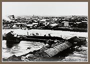
The 1869 collapse of the Hennepin Island tunnel
The leak turned into a torrent of water coming out the tunnel. The water blasted Hennepin Island, causing a 150 feet (45.7 m) chunk to fall off into the river. Believing that the mills and all the other industries around the falls would be ruined, hundreds of people rushed to view the impending disaster. Groups of volunteers started shoring up the gap by throwing trees and timber into the river, but that was ineffective. They then built a huge raft of timbers from the milling operations on Nicollet Island. This worked briefly, but also proved ineffective. A number of workers worked for months to build a dam that would funnel water away from the tunnel. The next year, an engineer from Lowell, Massachusetts
Lowell, Massachusetts
Lowell is a city in Middlesex County, Massachusetts, USA. According to the 2010 census, the city's population was 106,519. It is the fourth largest city in the state. Lowell and Cambridge are the county seats of Middlesex County...
recommended completing a wooden apron, sealing the tunnel, and building low dams above the falls to avoid exposing the limestone to the weather. This work was assisted by the federal government, and was eventually completed in 1884. The federal government spent $615,000 on this effort, while the two cities spent $334,500.
Locks and dams
United States Army Corps of Engineers
The United States Army Corps of Engineers is a federal agency and a major Army command made up of some 38,000 civilian and military personnel, making it the world's largest public engineering, design and construction management agency...
. The locks make commercial navigation possible above Minneapolis but, since the locks in Minneapolis are smaller than most of the locks on the river, the practical limit for many commercial tows is further downriver. Few barges go past St. Paul
Saint Paul, Minnesota
Saint Paul is the capital and second-most populous city of the U.S. state of Minnesota. The city lies mostly on the east bank of the Mississippi River in the area surrounding its point of confluence with the Minnesota River, and adjoins Minneapolis, the state's largest city...
.
Hydroelectricity
Hydroelectricity is the term referring to electricity generated by hydropower; the production of electrical power through the use of the gravitational force of falling or flowing water. It is the most widely used form of renewable energy...
dam
Dam
A dam is a barrier that impounds water or underground streams. Dams generally serve the primary purpose of retaining water, while other structures such as floodgates or levees are used to manage or prevent water flow into specific land regions. Hydropower and pumped-storage hydroelectricity are...
93 feet (28 m) in height. The upper pool has a normal capacity of 3150 acre.ft and a normal level of 799 feet (244 m) above sea level
Sea level
Mean sea level is a measure of the average height of the ocean's surface ; used as a standard in reckoning land elevation...
. The navigation channel required alteration of the historic Stone Arch Bridge, which now has a metal truss section to allow ships to pass below.
Completed in 1956, the lower St. Anthony Falls dam is a gravity-type hydro-electric dam 60 feet (18 m) in height, consisting of a 275 foot (84 m) long concrete spillway with 4 tainter gate
Tainter gate
The Tainter gate is a type of radial arm floodgate used in dams and canal locks to control water flow. It is named for Wisconsin structural engineer Jeremiah Burnham Tainter....
s. The lower pool (sometimes called the intermediate pool) has a normal capacity of 375 acre.ft and a normal level of 750 feet (229 m) above sea level.
The upper and lower locks are each 56 feet (17 m) wide by 400 feet (122 m) long.
The current around the spillway/falls is often swift and dangerous. In 1991, a small boat drifted too close and fell over one part of the dam. Two people onboard were killed, and two others had to be rescued by helicopter
Helicopter
A helicopter is a type of rotorcraft in which lift and thrust are supplied by one or more engine-driven rotors. This allows the helicopter to take off and land vertically, to hover, and to fly forwards, backwards, and laterally...
. Rescues at the site are usually much less dramatic, but continue to happen occasionally.
See also
- List of contributing properties in the St. Anthony Falls Historic District
- Saint Anthony MainSaint Anthony MainSaint Anthony Main is a shopping and office complex located on Main Street in the Nicollet Island/East Bank neighborhood of Southeast Minneapolis in the U.S. state of Minnesota. Commonly the area is associated with Northeast, Minneapolis as it is actually northeast of downtown on the east side of...
shopping area - Mississippi National River and Recreation AreaMississippi National River and Recreation AreaThe Mississippi National River and Recreation Area protects a and corridor along the Mississippi River from the cities of Dayton and Ramsey, Minnesota to just downstream of Hastings, Minnesota. This includes the stretch of Mississippi River which flows through Minneapolis and St. Paul, Minnesota...
- I-35W Mississippi River bridge, which collapsed in 2007 and temporarily blocked the lower pool.