

Geography of Norway
Encyclopedia
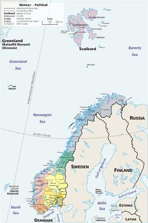
Norway
is a country located in Northern Europe
on the western and northern part of the Scandinavian Peninsula
, bordering the North Sea
in southwest and the Skagerrak
inlet to the south, the North Atlantic Ocean
(Norwegian Sea
) in the west and the Barents Sea
to the northeast. Norway has a long land border with Sweden
to the east, a shorter one with Finland
in the northeast and a still shorter border with Russia
in the far northeast.
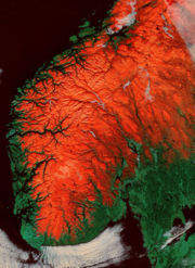
Norway has a very elongated shape, one of the longest and most rugged coastlines in the world, and some 50,000 islands off the much indented coastline. The mainland covers 13° latitude, from 58°N
to more than 71°N
, (Svalbard
north to 81°N
), and covers the longitude from 5°E
in Solund
to 31°E
in Vardø
(Jan Mayen
to 9°W
, Kvitøya
to 33°E
).
Norway is one of the world's most northerly countries, and one of Europe's most mountainous countries with large areas dominated by the Scandinavian Mountains
; average elevation is 460 m and 32% of the mainland is located above the tree line.
The country-length chain of peaks is geologically continuous with the mountains of Scotland
, Ireland
and, crossing the Atlantic Ocean
, the Appalachian Mountains
of North America
. Geologists hold that all these formed a single range prior to the breakup
of the ancient supercontinent
Pangaea
.
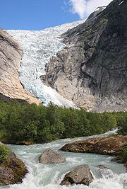
Virtually the entire country was covered with a thick ice sheet
during the last ice age
, as well as in many earlier ice ages. The movement of the ice carved out deep valley
s, and when the ice melted, the sea filled many of these valleys, creating Norway's famous fjord
s.
The land is still rebounding from the enormous weight of the ice (isostatic rebound), "growing out of the sea" with several mm a year, especially the eastern part of the country and the inner part of the long fjords, where the ice cover was thickest. This is a slow process, and for thousands of years following the end of the ice age, the sea covered substantial areas of what is today dry land. The sea reached what is today an elevation of 221 m in Oslo
(Aker), 25 m in Stavanger
, 5 m near Stad
, 180 m in Trondheim
, 50 m in Tromsø
and 75 m in Kirkenes
. This old seabed is now among the best agricultural land in the country.
The glaciers in the higher mountain areas today are not remnants of the large ice sheet of the ice age, their origins are more recent. The regional climate
was up to 1-3 °C warmer in 7000 B.C. to 3000 B.C. in the Holocene climatic optimum
, (relative to the 1961-90 period), melting the remaining glaciers in the mountains almost completely during that period.
As a result of the ice carving, Sognefjorden is the world's second deepest fjord and Hornindalsvatnet
is the deepest lake
in Europe
.
.jpg)
 Geographic coordinates:
62°N 10°E
Map references:
Europe
Area:
total:
324,220 km²
land:
307,860 km²
water:
16,360 km²
With Svalbard
and Jan Mayen
included: 385,199 km²
Area - comparative:
The contiguous area is slightly smaller than Vietnam
and slightly larger than New Mexico
.
With Svalbard and Jan Mayen included, the area is slightly larger than Japan
.
Land boundaries:
total:
2,515 km
border countries:
Finland
729 km, Sweden
1,619 km, Russia
196 km.
Coastline:
25,148 km (continental); 83,281 km (including islands)
Maritime claims:
contiguous zone:
10 nmi (18.5 km; 11.5 mi)
continental shelf:
200 nmi (370.4 km; 230.2 mi)
exclusive economic zone:
200 nmi (370.4 km; 230.2 mi)
territorial sea:
12 nmi (22.2 km; 13.8 mi)
Norways exclusive economic zone
(EEZ) totals 1 979 179 km², the largest in Western Europe
. The EEZ along the mainland makes up 878 575 km², the Jan Mayen EEZ makes up 293 049 km², and since 1977 Norway has claimed and upheld an economic zone around Svalbard of 803 993 km².
. The Scandinavian Mountains are the most defining feature of the country. Starting with Setesdalsheiene
north of the southern Skagerrak
coast, the mountains goes north, comprising large parts of the country, and intersected by the many fjords of Vestlandet
. This part includes Hardangervidda
, Jotunheimen
(with Galdhøpiggen
2469 m), Sognefjell and Trollheimen
in the north, with large glaciers, such as Jostedalsbreen
, Folgefonna
and Hardangerjøkulen
. The mountain chain swings eastwards south of Trondheim, with ranges such as Dovrefjell
and Rondane, and reaches to the border with Sweden, where they are mostly gently sloping plateaus. The mountains then follows the border in a northeasterly direction (known as Kjølen). The mountains are intersected by many fjords in Nordland
and Troms
, where they become more alpine and creates many islands as they meet the sea. The Scandinavian mountains forms the Lyngen Alps
and reaches into northwestern Finnmark
, gradually becoming lower from Altafjord
towards Nordkapp
(North Cape
), where they finally ends at the shores of the Barents sea
.
The Scandinavian Mountains have naturally divided the country in physical regions; valley
s radiate from the mountains in all directions. The following physical regions will only partially correspond to traditional regions and counties in Norway.
Southern coast
. The southern Skagerrak and North Sea coast is the lowland south of the mountain range, from Stavanger in the west to the western reaches of the outer part of the Oslofjord
in the east. In this part of the country, valleys tend to follow a north - south direction. This area is mostly a hilly area, but with some very flat areas such as Lista and Jæren
.
 Southeast
. The land east of the mountains (corresponding to Østlandet, most of Telemark
and Røros
) is dominated by valleys going in a north - south direction in the eastern part, and a more northwest - southeast direction further west, and the valleys congregate on the Oslofjord. The longest valleys in the country are Østerdal and Gudbrandsdal
. This part also contains larger areas of lowland surrounding the Oslofjord, as well as the Glomma
river and lake Mjøsa
.
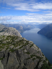
Western fjords
. The land west of the mountains (corresponding to Vestlandet north of Stavanger) is more dominated by the mountain chain, as the mountains goes all the way to the coast, albeit gradually becoming lower towards the coast. This part is dominated by large fjords, the largest are Sognefjord and Hardangerfjord
. Geirangerfjord
is often regarded as the ultimate fjord scenery. The coast is protected by a chain of skerries (the Skjærgård) arranged to parallel the coast and provide the beginning of a protected passage almost the entire 1,600 km route from Stavanger to Nordkapp. The fjords and most valleys generally goes in a west - east direction, and further north a more northwest - southeast direction.
Trondheim region
. The land north of Dovre (corresponding to Trøndelag except Røros) comprises a more gentle landscape with more rounded shapes and mountains, and with valleys congregating on the Trondheimsfjord
, where they open up and forms a larger lowland area. Further north is the valley of Namdalen
, opening up in the Namsos
area. However, the Fosen
peninsula, and the most northern coast (Leka
) is more dominated by mountains and more narrow valleys.
Northern fjords
. The land further north (corresponding to Nordland, Troms and northwestern Finnmark) is again more dominated by pointed mountains going all the way to the coast, and numerous fjords. The fjords and valleys generally lie in a west - east direction in the southern part of this area, and a more northwest - southeast direction further north. The Saltfjellet
mountain range is an exception, as the valleys goes in a more north - south direction from these mountains. This long area comprises many large islands, including Lofoten
, Vesterålen
and Senja
.
Far northeast. The interior and the coast east of Nordkapp (corresponding to Finnmarksvidda
and eastern Finnmark) is less dominated by mountains, and is mostly below 400 m. The interior is dominated by the large Finnmarksvidda plateau. There are large, wide fjords going in a north - south direction. This coast lacks the small islands forming the skerries
so typical of the Norwegian coast. Furthest to the east, the Varangerfjord
goes in an east - west direction, and is the only large fjord in the country opening up towards the east.
Svalbard
. Further north, in the Arctic ocean
, lies the Svalbard archipelago, which is also dominated by mountains, but these mountains are mostly covered by large glaciers, especially the eastern part of the archipelago, where glaciers cover more than 90%; Austfonna
is the largest glacier in Europe. Unlike the mainland, these glaciers calves directly in the open ocean.
Jan Mayen
. To the far northwest, halfway towards Greenland
, is the island Jan Mayen, where Beerenberg
is found, the only active volcano
in Norway.
Bouvet Island
. Located in the South Atlantic Ocean at 54°S
and mostly covered by glaciers, this island is one of the most remote islands in the world, inhabited only by seals
and birds.
Peter I Island
. This island in the South Pacific Ocean
at 69°S
, 90°W
is dominated by glaciers and a volcano. As with Bouvet Island, this island is regarded as an external dependency, and not part of the Kingdom.
Queen Maud Land
is Norway's claim in Antarctica. This large, sectorial
area stretches to the South Pole
and are completely dominated by the world's largest ice sheet
, but with some impressive nunatak
s penetrating above the ice. The Troll Research Station manned by Norway is located on a snow free mountain slope, the only station in Antarctica not to be located on the ice.
will have midnight sun and corresponding winter darkness, the length of both depends on the latitude
. In Longyearbyen
, the upper part of the sun disc is above the horizon (provided clear view against the northern horizon) from April 19 to August 23, and the winter darkness lasts from October 27 - February 14. The corresponding dates for Tromsø are May 17 - July 25, and November 26 - January 15. The winter darkness is not totally dark on the mainland; there is twilight for a few hours around noon in Tromsø, but in Longyearbyen there is near total darkness in the midst of the dark period. Even the southern part of the country experiences large seasonal variations in daylight; in Oslo the sun rises at 03:54 and sets 22:54 at summer solstice
, but is only above the horizon from 09:18 - 15:12 at winter solstice.
The northern part of the country is located in the aurora borealis zone; the aurora is occasionally seen in the southern part of the country.
Norway uses Central European Time
, corresponding to the 15°E
longitude. As the country is very elongated, this is at odds with the local daylight hours at the eastern and western parts. In Vardø the local daylight hours is 64 minutes earlier, and in Bergen it is 39 minutes later. Thus, Finnmark gains early morning daylight but loses evening daylight, and Vestlandet
loses early morning light but gains more evening daylight with this timezone. Daylight saving time
(GMT + 2) is observed from the last Sunday in March to the last Sunday in October.
The difference between low tide
and high tide is small on the southern coast and large in the north; ranging from on average 0.17 m in Mandal to about 0.30 m in Oslo and Stavanger, 0.90 m in Bergen, 1.80 m in Trondheim, Bodø and Hammerfest and as much as 2.17 m in Vadsø
.
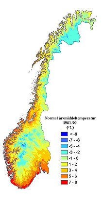 The climate of Norway is much more temperate than expected for such high latitude
s; this is mainly due to the North Atlantic Current
with its extension the Norwegian Current
raising the air temperature, and the prevailing southwesterlies bringing the mild air on shore, as well as the general southwest - northeast orientation of the coast allowing the westerlies to penetrate into the Arctic
. The January average in Brønnøysund
is almost 15 C-change warmer than the January average in Nome, Alaska
, even if both towns are situated on the west coast of the continents at 65°N. In July, the difference is reduced to 3 C-change. January average in Yakutsk
, situated inland in Siberia
but slightly further south, is 42 C-change colder than in Brønnøysund.
, particularly where the moist westerlies first are intercepted by high mountains; this occurs slightly inland from the outer skerry guard. Brekke
in Sogn og Fjordane
has the highest annual precipitation with 3575 mm (140.7 in); annual precipitation can exceed 5000 mm (196.9 in) in mountain areas near the coast. Lurøy
, near the Arctic Circle, gets 2,935 mm on average, a remarkable amount of precipitation for a polar location. Precipitation is heaviest in autumn and early winter along the coast, while April to June is the driest. The innermost parts of the long fjords are somewhat drier; annual precipitation in Lærdal
is 491 mm (19.3 in), in Levanger
750 mm (29.5 in) and only 300 mm (11.8 in) in Skibotn
at the head of Lyngenfjord, the latter also has the national record for clear-weather days. The regions to the east of the mountains (including Oslo
) have a more continental climate with less precipitation, and enjoy more sunshine and usually warmer summers; precipitation is highest in summer and early autumn (often brief, heavy showers) while winter and spring tend to be driest inland. Valleys surrounded by mountains can be very dry compared to nearby areas, and a larger area in the interior of Finnmark gets less than 400 mm (15.7 in) of precipitation annually. Svalbard Airport
has the lowest average annual precipitation with 190 mm (7.5 in), while Skjåk
has the lowest average on the mainland with only 278 mm (10.9 in), the lowest ever recorded on the mainland is 64 mm (2.5 in) at Hjerkinn
in Dovre
. Monthly averages varies from 5 mm (0.196850393700787 in) in April in Skjåk to 454 mm (17.9 in) in September in Brekke. Coastal areas from Lindesnes
north to Vardø
have more than 200 days/year with precipitation; however, this is with a very low threshold value (0.1 mm precipitation). The average annual number of days with at least 3 mm (0.118110236220472 in) precipitation is 77 in Blindern/Oslo
, 96 in Kjevik/Kristiansand
, 158 in Florida/Bergen
, 93 in Værnes/Trondheim
and 109 in Tromsø
.
with a coldest month of 2.7 °C (36.9 °F). The amplitude of inland areas are larger, with a maximum of 30 °C (86 °F) in Karasjok
. Finnmarksvidda
has the coldest winters in mainland Norway, but inland areas much further south can also see severe cold; Røros
has recorded -50 °C and Tynset
has a January average -13 °C. The islands in southern Lofoten
are the most northerly locations in the world where all winter months have mean temperatures above 0 °C (32 °F). Spring is the season when the temperature differences between the southern and northern part of the country is largest; this is also the time of year when daytime and nighttime temperatures differs the most. Inland valleys and the innermost fjord areas have less wind and sees the warmest summer days; the Oslofjord lowland is warmest with July 24-hr average of 17 °C (62.6 °F), but even Alta
at 70°N
has July average of 13.5 °C (56.3 °F), and commercial fruit
orchard
s are common in the innermost areas of the western fjords, but also in Telemark
. Inland areas reach their warmth peak around mid-July, and coastal areas by the first half of August. Humidity is usually low in summer.
The North Atlantic Current splits in two in the northern part of the Norwegian Sea; one branch goes east into the Barents Sea, while the other goes north along the west coast of Spitsbergen
; this modifies the Arctic polar climate
somewhat and results in open water throughout the year at higher latitude
s than any other place in the Arctic
. On the eastern coast of the Svalbard
archipelago
, the sea used to be frozen during most of the year, but the last years warming (graph) have seen open waters noticeably longer.
Normal monthly averages range from -17.1 °C in January in Karasjok 129 m (423 ft) amsl. to 17.3 °C (63.1 °F) in July in Oslo - Studenterlunden 15 m amsl. The warmest year average temperature is 7.7 °C (45.9 °F) in Skudeneshavn
in Karmøy
, and the coldest is -3.1 °C in Sihcajarvi in Kautokeino
(excluding higher mountains and Svalbard); this is a 10.8 C-change difference, about the same as the temperature difference between Skudeneshavn and Athens
, Greece.
The warmest temperature ever recorded in Norway is 35.6 °C (96.1 °F) in Nesbyen
. The coldest temperature ever recorded is −51.4 °C in Karasjok
. The warmest month on record was July 1901 in Oslo, with a mean (24hr) of 22.7 °C (72.9 °F), and the coldest month was February 1966 in Karasjok with a mean of -27.1 °C. Southwesterly winds further warmed by foehn can give warm temperatures in narrow fjords in winter; Tafjord
has recorded 17.9 °C (64.2 °F) in January and Sunndal
18.9 °C (66 °F) in February.
Compared to coastal areas, inland valleys and the innermost fjord areas have larger diurnal temperature variation
, especially in spring and summer. In July, the average daily high temperature is 20.1 °C (68.2 °F) in Lærdal and 17.8 °C (64 °F) in Karasjok, roughly 3 C-change warmer than coastal locations at the same latitude (see table).
As seen from the table, Norway's climate shows large variations, but with the exception of a small area along the northeastern coast in Finnmark
, all areas below the treeline (populated areas) of the Norwegian mainland has a temperate or subarctic climate (Köppen
groups C and D). Svalbard and Jan Mayen have polar climate (Köppen group E). More specifically, the climate is maritime mild temperate / marine west coast (Köppen
: Cfb) along the southwestern and part of the southern coast as in Bergen and Kristiansand; hemiboreal
/ humid continental (Dfb) in the lowlands in the southeast as in Oslo; cool maritime/subpolar oceanic (Cfc) along the northwestern coastal areas as in Svolvær; continental subarctic climate
(Dfc) in inland valleys and highlands below the treeline in much of the country and reaching to the coast in the northernmost part as seen in Geilo, Bardufoss and Kirkenes; alpine tundra
climate above the treeline in mountain areas all over the country as seen in Dovrefjell and Sognefjell. Polar tundra
(ET) is found at Jan Mayen and in the Svalbard archipelago including Longyearbyen, and also includes a narrow area along the northeastern coast from Nordkapp to Vardø
on the mainland. True ice cap climate (EF) can only be found at elevations higher than approximately 400–800 m in Svalbard and Jan Mayen, with the lowest temperatures on Nordaustlandet
.
Climate since 1990. Temperatures have tended to be higher in recent years, which may be a consequence of global warming
. Using the same data source but with the more recent 20-year period 1991-2010 as base period, this results in winter temperatures for the same stations that are 1 °C to 2.5 °C higher, while the July 24-hr average temperatures increases by approximately 1 °C. For Blindern/Oslo, the 1991-2010 period gives a January average of -2.4 °C and a July 24 hour average of 17.4 °C. For Bergen the corresponding temperatures are 2.6 °C and 15.5 °C, for Værnes/Trondheim -1.0 °C and 15.1 °C and for Langnes/Tromsø -2.5 °C and 12.1 °C. Compared to the 1961-90 period, a much larger area along the coast, from Kristiansand north to Svolvær, have average temperatures above freezing all year.
As a consequence of warming, summers last longer and winters are getting shorter; snow cover have tended to decrease in those lowland areas where winter temperatures often hover around freezing (including most major cities), while winter precipitation in the mountains and cold inland areas falls as snow, and might have increased in higher mountain areas. Using these recent 20 years as base period would result in substantial areas in Norway being classified in a different climate zone compared to 1961-90; Oslo and Trondheim would be maritime temperate (Cfb), Tromsø cool maritime (Cfc), and Lillehammer, earlier located at the intersection between subarctic (Dfc) and humid continental (Dfb) climate, would be firmly humid continental. Substantial mountain areas above the treeline would eventually be wooded.
The strongest warming has been observed on Svalbard, where the years 2005–2007 have been the warmest ever observed. In addition to warming, precipitation have increased on the mainland, especially in autumn and winter, increasing erosion
and the risk of landslide
s.
Sources: See references.
 Glaciated; mostly high plateaus and rugged mountains broken by fertile valleys; small, scattered plains; coastline deeply indented by fjords; arctic
tundra
only in the extreme northeast (largely found on the Varanger Peninsula
). Frozen ground all-year can also be found in the higher mountain areas and in the interior of Finnmark
county. Numerous glaciers are also found in Norway.
Elevation extremes:
lowest point:
Norwegian Sea
0 m
highest point:
Galdhøpiggen
2,469 m
than almost any other European country. There are approximately 60,000 species of different lifeforms in Norway and adjacent waters (excluding bacteria and virus). The Norwegian Shelf large marine ecosystem is considered highly productive. The total number of species include 16,000 species of insect
s (probably 4,000 more species yet to be described), 20,000 species of algae
, 1,800 species of lichen
, 1,050 species of moss
es, 2,800 species of vascular plant
s, up to 7,000 species of fungi, 450 species of bird
s (250 species nesting in Norway), 90 species of mammal
s, 45 fresh-water species of fish, 150 salt-water species of fish, 1,000 species of fresh-water invertebrate
s and 3,500 species of salt-water invertebrates. About 40,000 of these species have been described by science. The red list of 2006 encompasses 3,886 species. 17 species are listed mainly because they are endangered on a global scale, such as the European Beaver
, even if the population in Norway are not seen as endangered. There are 430 species of fungi on the red list, many of these are closely associated with the small remaining areas of old-growth forests. There are also 90 species of birds on the list and 25 species of mammal
s. 1,988 current species are listed as endangered or vulnerable as of 2006; of these are 939 listed as vulnerable (VU), 734 species are listed as endangered (EN), and 285 species are listed as critically endangered (CR) in Norway, among these are the gray wolf, the arctic fox
(healthy population on Svalbard) and the pool frog
.
The largest predator in Norwegian waters is the sperm whale
, and the largest fish is the basking shark
. The largest predator on land is the polar bear
, while the brown bear
is the largest predator on the Norwegian mainland, where the common moose
is the largest animal.
.png) Natural vegetation in Norway varies considerably, as can be expected in a country covering such a variation in latitude. There are generally fewer species of tree
Natural vegetation in Norway varies considerably, as can be expected in a country covering such a variation in latitude. There are generally fewer species of tree
s in Norway than in areas in western North America with a similar climate. This is because the migration routes after the ice age is more difficult in the north - south direction in Europe, with bodies of water (like the Baltic Sea
and the North Sea
) and mountains creating barriers, while in America there is a continuous continent and the mountains follow a north - south direction. Many imported plants have been able to ripen seeds and spread, and less than half of the 2,630 plant species in Norway today actually occur naturally in the country. About 210 species of plants growing in Norway are listed as endangered, and 13 species are endemic
. The national parks in Norway are mostly located in mountain areas; about 2 % of the productive forests in the country are protected.
Some plants are classified as western due to their need for high humidity and/or low tolerance of winter frost; these will stay close to the southwestern coast, with the northern limit near Ålesund; some examples are holly and bell heather
. Some western species occur north to Helgeland
(such as Erica tetralix
), some even to Lofoten (such as Luzula sylvatica
). The mild temperatures along the coast allows for some surprises; some hardy species of palm
grow even as far north as Sunnmøre
, one of the largest remaining Linden forest
in Europe grows at Flostranda in Stryn
and planted deciduous trees such as horse chestnut and beech thrives north of the Arctic circle
(as in Steigen
).
Plants classified as eastern need comparatively more summer sunshine, with less humidity, but can tolerate cold winters; these will often occur in the southeast and inland areas, examples are Daphne mezereum
, Fragaria viridis
and spiked speedwell. Some eastern species common in Siberia
grows in the river valleys of eastern Finnmark. There are also species which seems to be in-between these extremes, like the southern plants, where both winter and summer climate is important (such as pedunculate oak, European ash
and dog's mercury
); other plants are dependent on the type of bedrock.
There are a considerable number of alpine species in the mountains in Norway; these will not tolerate summers that are comparatively long and warm or can not compete with plants adapted to a longer and warmer growing season; many alpine plant
s are common in the North Boreal zone and some in the Middle Boreal zone, but their main area of distribution is on the alpine tundra
in the Scandinavian mountains and on the Arctic
tundra. Many of the most hardy species have adapted by using more than one summer to ripen seeds. Examples of alpine species are glacier buttercup
, Draba lactea
and Salix herbacea. A well-known anomaly is the 30 American alpine species, which in Europe only grow in two mountainous parts of Norway; the Dovre-Trollheimen and Jotunheim mountains in the south and the Saltdal
to western Finnmark in the north (Gjærevoll, 1992, pp 146–160; Moen, 1998, p 52). Other than in Norway, these species grow only in Canada and Greenland, such as the Braya linearis and Carex scirpoidea. It is unknown whether these survived the ice age on some mountain peak penetrating the ice, or they spread from further south in Europe, or why did they not spread to other mountainous regions of Europe. Some alpine species have a wider distribution and also grow in Siberia
, such as the Rhododendron lapponicum (Lapland rosebay). Other alpine species are common in the whole Arctic, some only grows in Europe, such as globe-flower. The following vegetation zones in Norway are all based on botanical criteria (Moen, 1998; Gjærevoll 1992), although, as mentioned, some plants will have specific demands. Forests, bogs and wetlands, as well as heaths, are all included in the different vegetation zones; a South Boreal bog will differ from a North Boreal bog, although some plant species might occur on both.
and east to Fevik
in Aust-Agder
(including Kristiansand) belongs to the Nemoral vegetation zone. This zone is located below 150 m above sea level and at most 30 km inland along the valleys. This is the vegetation zone dominating western Europe north of southern France. The hallmark of this zone in Norway is the domination of oak
and the virtual complete lack of typical boreal
species such as Norway spruce and grey alder
, although a lowland variant of pine
occurs. Nemoral covers a total of 0.5% of the land area (excluding Svalbard and Jan Mayen).
zone covers a total of 7% of the land area in Norway, including 80% of Østfold
and Vestfold
. This vegetation represents a mix of nemoral and boreal plant species, and belong to the Palearctic
Sarmatic mixed forests
PA0436 terrestrial ecoregion. The nemoral species tend to dominate slopes facing south - west and on good soil, while the boreal species dominate on slopes facing north and on waterlogged soil. In some areas other factors overrule this, as in areas where the bedrock gives little nutritients, where oak and the boreal pine
often share domination. The boreonemoral zone follows the coast from Oslofjord
north to Ålesund
, becoming discountineous north of Sunnmøre
. In Oslo, this zone reaches an elevation of 200 m above sea, and it also reaches into some of the lower valleys and just reaches the lowland around Mjøsa
, but not as far north as Lillehammer
. In the valleys of the south, this vegetation might exist up to 300 – 400 m above sea level. The zone follows the lowland of the west coast and into the largest fjords, reaching an elevation of 150 m here, even 300 meter in some sheltered fjords and valleys in Nordmøre
with nutritients-rich soil. The northernmost locations in the world are several areas along the Trondheimsfjord
, such as Frosta
, and the northernmost single location is Byahalla in Steinkjer
. Some nemoral species in this zone are English oak, sessile oak
, European ash, elm, Norway maple
, hazel
, black alder, lime, yew, holly
(southwest coast), wild cherry, ramsons, beech (a late arriver and only common in Vestfold
) and Primula vulgaris
. Typical boreal species are Norway spruce
, pine, downy birch
, grey alder, aspen
, rowan
, wood anemone
and Viola riviniana
.
length and summer warmth. Bog
s are common in the boreal zone, with the largest areas in the North and Middle Boreal Zones, as well as in the area just above the tree line. The large boreal zone is usually divided into three subzones:
 The South Boreal zone (SB) is dominated by boreal species, especially Norway spruce, and covers a total of 12% of the land area. The SB is the only boreal zone with a few scattered - but well-developed - warmth-demanding broadleaf deciduous trees, such as European Ash and Oak. A number of species in this zone needs fairly warm summers (SB has 3–4 months with a mean 24-hr temperature of at least 10 °C), and thus are not to be found or are very rare in the middle boreal zone. Some of the species not to be found further north are black alder, hop
, oregano and guelder rose
. This zone is found above the hemiboreal zone, up to 450 meter amsl in Østlandet
and 500 m in the most southern valleys. In the eastern valleys it reaches several hundred kilometers into Gudbrandsdal and Østerdal, and up to Lom
and Skjåk
in Ottadalen. Along the southwestern coast, the zone reaches an elevation of 400 at the head of the large fjords (as in Lærdal), and about 300 m nearer to the coast. Norway spruce is lacking in Vestlandet
(Voss
is an exception). North of Ålesund, SB vegetation dominates in the lowland down to sea level, including the islands like Hitra
. Most of the lowland in Trøndelag below 180 m elevation is SB, up to 300 m above sea level in the inland vallys such as Gauldalen and Verdalen
, and up to 100 m in Namdalen
. The coastal areas and some fjord areas further north, such as Vikna
, Brønnøy
and the best locations along the Helgeland
coast is SB north to the mouth of Ranfjord
, while inland areas north of Grong
are dominated by Middle Boreal zone in the lowland. There are small isolated areas with SB vegetation further north, as in Bodø
and Fauske
; the most northern location is a narrow strip along the northern shore of Ofotfjord
. The endemic Nordland-whitebeam
only grows in Bindal
. Agriculture in Norway, including grain
cultivation, takes place mostly in the hemiboreal and SB zone.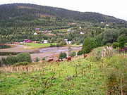
(the siberian spruce variant occurs in the Pasvik valley) due to mountain ranges blocking the advance, but is often planted in MB areas further north for economic reasons, contributing to a different landscape. Birch is usually dominant in these northern areas, but pine, aspen, rowan, bird cherry
and grey alder are also common. This MB birch is often a cross between silver birch
and downy birch
and is larger (6 – 12 m) than the birch growing near the tree line; conifers will grow taller. Some alpine plants grow in the MB zone, nemoral species are rare. The understory
is usually well developed if the forest is not too dense, and many plants do not grow further north. Grey alder, silver birch, yellow bedstraw
, raspberry
, mugwort
and Myrica gale
are examples of species in this zone which do not grow further north or higher up. MB is located at an altitude of 400 – 750 m in Østlandet, up to 800 m in the southern valleys, from 300 m to 600 m (800 m at the head of the long fjords) on the southwest coast, and from 180 – 450 m in Trøndelag (700 m in the interior, as in Røros and Oppdal
). Further north, MB is common in the lowland, up to 100 m above sea level in Lofoten and Vesterålen, 200 m above sea level in Narvik
, 100 m in Tromsø, 130 m - 200 m in inland valleys in Troms, and the lowland at the head of Altafjord
is the most northerly area of any size; small pockets exist in Porsanger
and Sør-Varanger
. This is usually the most northerly area with some farming activity, and Barley
was traditionally grown even as far north as Alta
.
). Spruce and pine make up the tree line in some mountain areas with a more continental climate. Alpine plants are common in this zone. Birch forest at 1,320 m above sea level at Sikilsdalshorn is the highest tree line in Norway. The tree line is lower closer to the coast and in areas with lower mountains due to cooler summers, more wind near mountain summits, and more snow in the winter (coastal mountains) leading to later snowmelt. The NB zone is located at 750 – 950 m altitude in the interior of Østlandet and covers large areas; at 800 – 1200 m in the central mountain areas; but at the western coast the tree line is down to about 500 m above sea level, increasing significantly into the long fjords (1,100 m at the head of Sognefjord
). Further north, large areas in the interior highlands or uplands of Trøndelag and North Norway is dominated by the NB zone, with the tree line at about 800 m amsl in the interior of Trøndelag, 600 m in Rana
, 500 m in Narvik, 400 m in Tromsø, 100 m in Hammerfest
(only pockets in sheltered areas) and 200 m in Kirkenes. The large Finnmarksvidda
plateau is at an altitude placing it almost exactly at the tree line. The last patch of NB zone gives way to tundra at sea level about 10 km south of the North Cape
plateau (near Skarsvåg
); areas south of this line is tundra-like with scattered patches of mountain birch woodland (forest tundra) and becomes alpine tundra even at minor elevations. The trees near the tree line is often bent by snow, wind and growing season frost; height is only 2 – 4 m. Outside Norway (and adjacent areas in Sweden), the only other areas in the world with the tree line mostly made up by a small-leaved deciduous tree like birch - in contrast to conifers - are Iceland
and the Kamtschatka peninsula.
A conifer tree line is sometimes used (No: Barskoggrense) to divide this zone into two subzones, as the conifers will (usually) not grow as high up as the mountain birch. Spruce and pine grow at nearly 1,100 m above sea level in some areas of Jotunheimen, down to 400 m in Bergen (900 m at the head of Sognefjord), 900 m in Lillehammer (mountains near Oslo too low to observe a tree line), 500 m in Trondheim (750 m in Oppdal), 350 m in Narvik, 200 m in Harstad, 250 m in Alta and the most northerly pine forest in the world is in Stabbursdalen National Park in Porsanger
. There are some forestry in this part of the NB zone; some conifers can grow quite large even if growth is slow.
PA0608 ecoregion. The Scandinavian coastal conifer forests
PA0520 ecoregion in coastal and fjord areas with mild winters follows the coast from south of Stavanger and north to southern Troms and includes both hemiboreal and boreal areas. The area above the conifer tree line is made up by mountain birch Betula pubescens ssp. czerepanovii (No: fjellbjørkeskog) and belong to the Scandinavian Montane Birch forest and grasslands
PA1110 tundra ecoregion. This region is sometimes used for the entire area outside the range of spruce forests, erroneously labeling the MB and lower part of NB vegetation areas as tundra. Restricting the PA1110 ecoregion to include areas above the conifer tree line, this region still make up approximately 45% of the mainland.
and S. lapponum 0.5 meter tall; blueberry
, common juniper
and twinflower are common. The low alpine area was traditionally used as summer pastures, and partly still is. This zone reaches an elevation of 1,500 m in Jotunheimen and includes most of Hardangervidda
, it reaches 1,300 m in eastern Trollheimen
and about 800 m in Narvik and the Lyngen Alps
. Higher up (mid-alpine tundra) the plants become smaller, mosses and lichens are more predominant; plants still cover most of the ground even if snowfields last into mid-summer and permafrost are common. At the highest elevations (high-alpine tundra) the ground is dominated by bare rock, snow and glaciers, with few plants..jpg) The highest altitude weather station in Norway, Fanaråken in Luster
The highest altitude weather station in Norway, Fanaråken in Luster
at 2062 m, barely have three months above freezing and a July average of 2.7 °C. Still, glacier buttercup has been found only 100 m below the summit of Galdhøpiggen
, and mosses and lichens have been found at the summit. In northeastern Finnmark (northern half of the Varanger Peninsula
and Nordkinn Peninsula
) is a small lowland tundra area which is often considered part of the Kola Peninsula tundra PA1106 ecoregion. Svalbard and Jan Mayen have tundra vegetation except for areas covered by glaciers, and some areas, like the cliffs at southern Bear Island, are fertilized by sea bird colonies. This tundra is often considered part of the Arctic Desert PA1101 ecoregion. The most lush areas on these Arctic islands are sheltered fjord areas at Spitsbergen
; they have the highest summer temperatures and the very dry climate ensures little snow and thus comparatively early snowmelt
. The short growing season and the permafrost
underneath the active layer still ensures enough moisture; plants include dwarf birch
, cloudberry, Svalbard poppy
and harebell.
A warmer climate would push the vegetation zones significantly northwards and upwards.
Resources: Petroleum
, copper
, natural gas
, pyrites, nickel
, iron ore, zinc
, lead
, fish
, timber
, hydropower
.
 arable land
:
3.3% (in use; some more marginal areas are not in use or used as pasture
s)
permanent crops:
0%
permanent pastures:
0%
forests and woodland:
38% of land area is covered by forest; 21% by conifer forest
, 17% deciduous forest,; increasing as many pastures in the higher elevations and some coastal, man-made heaths
are no longer used or reforested, and due to warmer summers.
other:
59% (mountains and heaths 46%, bog
s and wetland
s 6.3%, lakes and rivers 5.3%, urban areas 1.1%). Source: Moen et al.: Vegetasjon: National Atlas of Norway)
Irrigated land:
970 km² (1993 est.)
Natural hazards:
emissions, pollution
of the air and water, loss of habitat, damage to cold water coral reefs from trawlers, and salmon fish farming threatening the wild salmon by spawning in the rivers, thereby diluting the local DNA. Acid rain has damaged lakes, rivers and forest, especially in the southernmost part of the country, and most wild salmon populations in Sørlandet
have died. Due to lower emissions in Europe, acid rain in Norway has decreased by 40% from 1980 to 2003. Another concern is a possible increase in extreme weather. In the future, climate models predict increased precipitation, especially in the areas with current high precipitation, and also predict more episodes with heavy precipitation within a short time span, which can cause landslides and local floods. Winters will probably be significant milder, and the sea ice cover in the Arctic ocean
might melt altogether in summer, threatening the survival of the polar bear
on Svalbard. Both terrestrial and aquatic species are expected to shift northwards, and this is already observed for some species: migratory birds arriving earlier, trees coming into leaf earlier, Mackerel
becoming common in summer off the coast of Troms
, the growing red deer
population is spreading northwards and eastwards and 2008 was the first hunting season which saw more red deer (35,700) than moose
shot. The total number of species in Norway are expected to rise due to new species arriving. Norwegians are statistically among the world's most worried when it comes to global warming and its effects, even if Norway is among the countries expected to be least negatively affected by global warming, with some possible gains.
 party to:
Air Pollution
, Air Pollution-Nitrogen Oxides, Air Pollution-Persistent Organic Pollutants, Air Pollution-Sulphur 85, Air Pollution-Sulphur 94, Air Pollution-Volatile Organic Compounds, Antarctic-Environmental Protocol, Antarctic Treaty, Biodiversity
, Climate Change
, Desertification
, Endangered Species
, Environmental Modification, Hazardous Wastes, Law of the Sea
, Marine Dumping, Nuclear Test Ban, Ozone Layer Protection, Ship Pollution
, Tropical Timber 83, Tropical Timber 94, Wetlands, Whaling
, Climate Change-Kyoto Protocol, European Agreement concerning the International Carriage of Dangerous Goods by Road
Geography - note:
Strategic location adjacent to sea lanes and air routes in the North Atlantic Ocean
.
to any land mass. However, Svalbard
is antipodal to the western coast of Marie Byrd Land
in Antarctica and adjacent parts of the Ross Ice Shelf
. The antipodes of Jan Mayen
are off the Oates Coast
of Antarctica.
Peter I Island
off Antarctica, which is claimed by Norway, is opposite a spot 70 km SE of Norilsk
in Russian Siberia.
Norway
Norway , officially the Kingdom of Norway, is a Nordic unitary constitutional monarchy whose territory comprises the western portion of the Scandinavian Peninsula, Jan Mayen, and the Arctic archipelago of Svalbard and Bouvet Island. Norway has a total area of and a population of about 4.9 million...
is a country located in Northern Europe
Europe
Europe is, by convention, one of the world's seven continents. Comprising the westernmost peninsula of Eurasia, Europe is generally 'divided' from Asia to its east by the watershed divides of the Ural and Caucasus Mountains, the Ural River, the Caspian and Black Seas, and the waterways connecting...
on the western and northern part of the Scandinavian Peninsula
Scandinavian Peninsula
The Scandinavian Peninsula is a peninsula in Northern Europe, which today covers Norway, Sweden, and most of northern Finland. Prior to the 17th and 18th centuries, large parts of the southern peninsula—including the core region of Scania from which the peninsula takes its name—were part of...
, bordering the North Sea
North Sea
In the southwest, beyond the Straits of Dover, the North Sea becomes the English Channel connecting to the Atlantic Ocean. In the east, it connects to the Baltic Sea via the Skagerrak and Kattegat, narrow straits that separate Denmark from Norway and Sweden respectively...
in southwest and the Skagerrak
Skagerrak
The Skagerrak is a strait running between Norway and the southwest coast of Sweden and the Jutland peninsula of Denmark, connecting the North Sea and the Kattegat sea area, which leads to the Baltic Sea.-Name:...
inlet to the south, the North Atlantic Ocean
Atlantic Ocean
The Atlantic Ocean is the second-largest of the world's oceanic divisions. With a total area of about , it covers approximately 20% of the Earth's surface and about 26% of its water surface area...
(Norwegian Sea
Norwegian Sea
The Norwegian Sea is a marginal sea in the North Atlantic Ocean, northwest of Norway. It is located between the North Sea and the Greenland Sea and adjoins the North Atlantic Ocean to the west and the Barents Sea to the northeast. In the southwest, it is separated from the Atlantic Ocean by a...
) in the west and the Barents Sea
Barents Sea
The Barents Sea is a marginal sea of the Arctic Ocean, located north of Norway and Russia. Known in the Middle Ages as the Murman Sea, the sea takes its current name from the Dutch navigator Willem Barents...
to the northeast. Norway has a long land border with Sweden
Sweden
Sweden , officially the Kingdom of Sweden , is a Nordic country on the Scandinavian Peninsula in Northern Europe. Sweden borders with Norway and Finland and is connected to Denmark by a bridge-tunnel across the Öresund....
to the east, a shorter one with Finland
Finland
Finland , officially the Republic of Finland, is a Nordic country situated in the Fennoscandian region of Northern Europe. It is bordered by Sweden in the west, Norway in the north and Russia in the east, while Estonia lies to its south across the Gulf of Finland.Around 5.4 million people reside...
in the northeast and a still shorter border with Russia
Russia
Russia or , officially known as both Russia and the Russian Federation , is a country in northern Eurasia. It is a federal semi-presidential republic, comprising 83 federal subjects...
in the far northeast.
Norway has a very elongated shape, one of the longest and most rugged coastlines in the world, and some 50,000 islands off the much indented coastline. The mainland covers 13° latitude, from 58°N
58th parallel north
The 58th parallel north is a circle of latitude that is 58 degrees north of the Earth's equatorial plane. It crosses Europe, Asia, the Pacific Ocean, North America, and the Atlantic Ocean....
to more than 71°N
71st parallel north
The 71st parallel north is a circle of latitude that is 71 degrees north of the Earth's equatorial plane, in the Arctic. It crosses the Atlantic Ocean, Europe, Asia and North America, and passes through some of the southern seas of the Arctic Ocean....
, (Svalbard
Svalbard
Svalbard is an archipelago in the Arctic, constituting the northernmost part of Norway. It is located north of mainland Europe, midway between mainland Norway and the North Pole. The group of islands range from 74° to 81° north latitude , and from 10° to 35° east longitude. Spitsbergen is the...
north to 81°N
81st parallel north
The 81st parallel north is a circle of latitude that is 81 degrees north of the Earth's equatorial plane, in the Arctic. It crosses the Atlantic Ocean, Europe, Asia, the Arctic Ocean and North America....
), and covers the longitude from 5°E
5th meridian east
The meridian 5° east of Greenwich is a line of longitude that extends from the North Pole across the Arctic Ocean, Europe, Africa, the Atlantic Ocean, the Southern Ocean, and Antarctica to the South Pole....
in Solund
Solund
Solund is a municipality in the county of Sogn og Fjordane, Norway. It is located in the traditional district of Sogn. Solund is the westernmost island municipality in Norway, and the only municipality in Sogn og Fjordane county that is made up only of islands...
to 31°E
31st meridian east
The meridian 31° east of Greenwich is a line of longitude that extends from the North Pole across the Arctic Ocean, Europe, Turkey, Africa, the Indian Ocean, the Southern Ocean, and Antarctica to the South Pole....
in Vardø
Vardø
is a town and a municipality in Finnmark county in the extreme northeast part of Norway.Vardø was established as a municipality on 1 January 1838 . The law required that all cities should be separated from their rural districts, but because of a low population and very few voters, this was...
(Jan Mayen
Jan Mayen
Jan Mayen Island is a volcanic island in the Arctic Ocean and part of the Kingdom of Norway. It is long and 373 km2 in area, partly covered by glaciers . It has two parts: larger northeast Nord-Jan and smaller Sør-Jan, linked by an isthmus wide...
to 9°W
9th meridian west
The meridian 9° west of Greenwich is a line of longitude that extends from the North Pole across the Arctic Ocean, the Atlantic Ocean, Europe, Africa, the Southern Ocean, and Antarctica to the South Pole....
, Kvitøya
Kvitøya
Kvitøya is an island in the Svalbard archipelago in the Arctic Ocean, with an area of . It is located at , making it the easternmost part of the Kingdom of Norway...
to 33°E
33rd meridian east
The meridian 33° east of Greenwich is a line of longitude that extends from the North Pole across the Arctic Ocean, Europe, Turkey, Africa, the Indian Ocean, the Southern Ocean, and Antarctica to the South Pole....
).
Norway is one of the world's most northerly countries, and one of Europe's most mountainous countries with large areas dominated by the Scandinavian Mountains
Scandinavian Mountains
The Scandinavian Mountains or the Scandes, in Swedish Skanderna, Fjällen or Kölen , in Finnish Köli and in Norwegian Kjølen, with the three latter meaning The Keel, are a mountain range that runs through the Scandinavian Peninsula...
; average elevation is 460 m and 32% of the mainland is located above the tree line.
The country-length chain of peaks is geologically continuous with the mountains of Scotland
Scotland
Scotland is a country that is part of the United Kingdom. Occupying the northern third of the island of Great Britain, it shares a border with England to the south and is bounded by the North Sea to the east, the Atlantic Ocean to the north and west, and the North Channel and Irish Sea to the...
, Ireland
Ireland
Ireland is an island to the northwest of continental Europe. It is the third-largest island in Europe and the twentieth-largest island on Earth...
and, crossing the Atlantic Ocean
Atlantic Ocean
The Atlantic Ocean is the second-largest of the world's oceanic divisions. With a total area of about , it covers approximately 20% of the Earth's surface and about 26% of its water surface area...
, the Appalachian Mountains
Appalachian Mountains
The Appalachian Mountains #Whether the stressed vowel is or ,#Whether the "ch" is pronounced as a fricative or an affricate , and#Whether the final vowel is the monophthong or the diphthong .), often called the Appalachians, are a system of mountains in eastern North America. The Appalachians...
of North America
North America
North America is a continent wholly within the Northern Hemisphere and almost wholly within the Western Hemisphere. It is also considered a northern subcontinent of the Americas...
. Geologists hold that all these formed a single range prior to the breakup
Continental drift
Continental drift is the movement of the Earth's continents relative to each other. The hypothesis that continents 'drift' was first put forward by Abraham Ortelius in 1596 and was fully developed by Alfred Wegener in 1912...
of the ancient supercontinent
Supercontinent
In geology, a supercontinent is a landmass comprising more than one continental core, or craton. The assembly of cratons and accreted terranes that form Eurasia qualifies as a supercontinent today.-History:...
Pangaea
Pangaea
Pangaea, Pangæa, or Pangea is hypothesized as a supercontinent that existed during the Paleozoic and Mesozoic eras about 250 million years ago, before the component continents were separated into their current configuration....
.
Virtually the entire country was covered with a thick ice sheet
Ice sheet
An ice sheet is a mass of glacier ice that covers surrounding terrain and is greater than 50,000 km² , thus also known as continental glacier...
during the last ice age
Ice age
An ice age or, more precisely, glacial age, is a generic geological period of long-term reduction in the temperature of the Earth's surface and atmosphere, resulting in the presence or expansion of continental ice sheets, polar ice sheets and alpine glaciers...
, as well as in many earlier ice ages. The movement of the ice carved out deep valley
Valley
In geology, a valley or dale is a depression with predominant extent in one direction. A very deep river valley may be called a canyon or gorge.The terms U-shaped and V-shaped are descriptive terms of geography to characterize the form of valleys...
s, and when the ice melted, the sea filled many of these valleys, creating Norway's famous fjord
Fjord
Geologically, a fjord is a long, narrow inlet with steep sides or cliffs, created in a valley carved by glacial activity.-Formation:A fjord is formed when a glacier cuts a U-shaped valley by abrasion of the surrounding bedrock. Glacial melting is accompanied by rebound of Earth's crust as the ice...
s.
The land is still rebounding from the enormous weight of the ice (isostatic rebound), "growing out of the sea" with several mm a year, especially the eastern part of the country and the inner part of the long fjords, where the ice cover was thickest. This is a slow process, and for thousands of years following the end of the ice age, the sea covered substantial areas of what is today dry land. The sea reached what is today an elevation of 221 m in Oslo
Oslo
Oslo is a municipality, as well as the capital and most populous city in Norway. As a municipality , it was established on 1 January 1838. Founded around 1048 by King Harald III of Norway, the city was largely destroyed by fire in 1624. The city was moved under the reign of Denmark–Norway's King...
(Aker), 25 m in Stavanger
Stavanger
Stavanger is a city and municipality in the county of Rogaland, Norway.Stavanger municipality has a population of 126,469. There are 197,852 people living in the Stavanger conurbation, making Stavanger the fourth largest city, but the third largest urban area, in Norway...
, 5 m near Stad
Stad (peninsula)
Stad or Stadlandet is a peninsula in the municipality of Selje in Sogn og Fjordane county, Norway.The name is sometimes also written as Stadt, Statt or Stadlandet–not to be confused with the similar German word Stadt. The d in Stad is pronounced in Norwegian as a t. The Stad peninsula has a...
, 180 m in Trondheim
Trondheim
Trondheim , historically, Nidaros and Trondhjem, is a city and municipality in Sør-Trøndelag county, Norway. With a population of 173,486, it is the third most populous municipality and city in the country, although the fourth largest metropolitan area. It is the administrative centre of...
, 50 m in Tromsø
Tromsø
Tromsø is a city and municipality in Troms county, Norway. The administrative centre of the municipality is the city of Tromsø.Tromsø city is the ninth largest urban area in Norway by population, and the seventh largest city in Norway by population...
and 75 m in Kirkenes
Kirkenes
is a town in the municipality of Sør-Varanger in the county of Finnmark in the far northeast of Norway...
. This old seabed is now among the best agricultural land in the country.
The glaciers in the higher mountain areas today are not remnants of the large ice sheet of the ice age, their origins are more recent. The regional climate
Climate
Climate encompasses the statistics of temperature, humidity, atmospheric pressure, wind, rainfall, atmospheric particle count and other meteorological elemental measurements in a given region over long periods...
was up to 1-3 °C warmer in 7000 B.C. to 3000 B.C. in the Holocene climatic optimum
Holocene climatic optimum
The Holocene Climate Optimum was a warm period during roughly the interval 9,000 to 5,000 years B.P.. This event has also been known by many other names, including: Hypsithermal, Altithermal, Climatic Optimum, Holocene Optimum, Holocene Thermal Maximum, and Holocene Megathermal.This warm period...
, (relative to the 1961-90 period), melting the remaining glaciers in the mountains almost completely during that period.
As a result of the ice carving, Sognefjorden is the world's second deepest fjord and Hornindalsvatnet
Hornindalsvatnet
Hornindalsvatnet is Norway's and Europe's deepest lake, officially measured to a depth of . Its surface is above sea level, which means that its bottom is below sea level. The village of Grodås lies at the eastern end of the lake in Hornindal and the village of Mogrenda is located on the...
is the deepest lake
Lake
A lake is a body of relatively still fresh or salt water of considerable size, localized in a basin, that is surrounded by land. Lakes are inland and not part of the ocean and therefore are distinct from lagoons, and are larger and deeper than ponds. Lakes can be contrasted with rivers or streams,...
in Europe
Europe
Europe is, by convention, one of the world's seven continents. Comprising the westernmost peninsula of Eurasia, Europe is generally 'divided' from Asia to its east by the watershed divides of the Ural and Caucasus Mountains, the Ural River, the Caspian and Black Seas, and the waterways connecting...
.
Statistics
62°N 10°E
Map references:
Europe
Europe
Europe is, by convention, one of the world's seven continents. Comprising the westernmost peninsula of Eurasia, Europe is generally 'divided' from Asia to its east by the watershed divides of the Ural and Caucasus Mountains, the Ural River, the Caspian and Black Seas, and the waterways connecting...
Area:
total:
324,220 km²
land:
307,860 km²
water:
16,360 km²
With Svalbard
Svalbard
Svalbard is an archipelago in the Arctic, constituting the northernmost part of Norway. It is located north of mainland Europe, midway between mainland Norway and the North Pole. The group of islands range from 74° to 81° north latitude , and from 10° to 35° east longitude. Spitsbergen is the...
and Jan Mayen
Jan Mayen
Jan Mayen Island is a volcanic island in the Arctic Ocean and part of the Kingdom of Norway. It is long and 373 km2 in area, partly covered by glaciers . It has two parts: larger northeast Nord-Jan and smaller Sør-Jan, linked by an isthmus wide...
included: 385,199 km²
Area - comparative:
The contiguous area is slightly smaller than Vietnam
Vietnam
Vietnam – sometimes spelled Viet Nam , officially the Socialist Republic of Vietnam – is the easternmost country on the Indochina Peninsula in Southeast Asia. It is bordered by China to the north, Laos to the northwest, Cambodia to the southwest, and the South China Sea –...
and slightly larger than New Mexico
New Mexico
New Mexico is a state located in the southwest and western regions of the United States. New Mexico is also usually considered one of the Mountain States. With a population density of 16 per square mile, New Mexico is the sixth-most sparsely inhabited U.S...
.
With Svalbard and Jan Mayen included, the area is slightly larger than Japan
Japan
Japan is an island nation in East Asia. Located in the Pacific Ocean, it lies to the east of the Sea of Japan, China, North Korea, South Korea and Russia, stretching from the Sea of Okhotsk in the north to the East China Sea and Taiwan in the south...
.
Land boundaries:
total:
2,515 km
border countries:
Finland
Finland
Finland , officially the Republic of Finland, is a Nordic country situated in the Fennoscandian region of Northern Europe. It is bordered by Sweden in the west, Norway in the north and Russia in the east, while Estonia lies to its south across the Gulf of Finland.Around 5.4 million people reside...
729 km, Sweden
Sweden
Sweden , officially the Kingdom of Sweden , is a Nordic country on the Scandinavian Peninsula in Northern Europe. Sweden borders with Norway and Finland and is connected to Denmark by a bridge-tunnel across the Öresund....
1,619 km, Russia
Russia
Russia or , officially known as both Russia and the Russian Federation , is a country in northern Eurasia. It is a federal semi-presidential republic, comprising 83 federal subjects...
196 km.
Coastline:
25,148 km (continental); 83,281 km (including islands)
Maritime claims:
contiguous zone:
10 nmi (18.5 km; 11.5 mi)
continental shelf:
200 nmi (370.4 km; 230.2 mi)
exclusive economic zone:
200 nmi (370.4 km; 230.2 mi)
territorial sea:
12 nmi (22.2 km; 13.8 mi)
Norways exclusive economic zone
Exclusive Economic Zone
Under the law of the sea, an exclusive economic zone is a seazone over which a state has special rights over the exploration and use of marine resources, including production of energy from water and wind. It stretches from the seaward edge of the state's territorial sea out to 200 nautical...
(EEZ) totals 1 979 179 km², the largest in Western Europe
Western Europe
Western Europe is a loose term for the collection of countries in the western most region of the European continents, though this definition is context-dependent and carries cultural and political connotations. One definition describes Western Europe as a geographic entity—the region lying in the...
. The EEZ along the mainland makes up 878 575 km², the Jan Mayen EEZ makes up 293 049 km², and since 1977 Norway has claimed and upheld an economic zone around Svalbard of 803 993 km².
Physical geography
Scandinavian MountainsScandinavian Mountains
The Scandinavian Mountains or the Scandes, in Swedish Skanderna, Fjällen or Kölen , in Finnish Köli and in Norwegian Kjølen, with the three latter meaning The Keel, are a mountain range that runs through the Scandinavian Peninsula...
. The Scandinavian Mountains are the most defining feature of the country. Starting with Setesdalsheiene
Setesdalsheiene
Setesdalsheiene is the collective term for the mountains to the west and east of the Setesdalen valley in Aust-Agder and Vest-Agder counties in Southern Norway. The river Otra flows through the valley between the mountains....
north of the southern Skagerrak
Skagerrak
The Skagerrak is a strait running between Norway and the southwest coast of Sweden and the Jutland peninsula of Denmark, connecting the North Sea and the Kattegat sea area, which leads to the Baltic Sea.-Name:...
coast, the mountains goes north, comprising large parts of the country, and intersected by the many fjords of Vestlandet
Vestlandet
Western Norway is the region along the Atlantic coast of southern Norway. It consists of the counties Rogaland, Hordaland, Sogn og Fjordane, and Møre og Romsdal and the region has a population of approximately 1.3 million people. The largest city is Bergen, second largest is Stavanger...
. This part includes Hardangervidda
Hardangervidda
The Hardangervidda is a mountain plateau in the Hardanger region of western Norway. It is the largest such plateau in Europe, with a cold year-round alpine climate and is the site of one of Norway's largest glaciers. Much of the plateau is protected as part of Hardangervidda National Park; it is a...
, Jotunheimen
Jotunheimen
Jotunheimen is a mountainous area of roughly 3,500 km² in Southern Norway and is part of the long range known as the Scandinavian Mountains. The 29 highest mountains in Norway are all in Jotunheimen, including the very highest - Galdhøpiggen...
(with Galdhøpiggen
Galdhøpiggen
Galdhøpiggen is the highest mountain in Norway, Scandinavia and Northern Europe, at 2,469 m above sea level...
2469 m), Sognefjell and Trollheimen
Trollheimen
Trollheimen is a mountain range in Møre og Romsdal and Sør-Trøndelag counties in central Norway. The mountain range is part of the Scandinavian Mountains.- Etymology :...
in the north, with large glaciers, such as Jostedalsbreen
Jostedalsbreen
Jostedalsbreen is the largest glacier in continental Europe. It is situated in Sogn og Fjordane county in Western Norway. Jostedalsbreen lies in the municipalities of Luster, Balestrand, Jølster, and Stryn. The highest peak in the area is Lodalskåpa at a height of .Jostedalsbreen has a total area...
, Folgefonna
Folgefonna
Folgefonna is a collective term for three plateau glaciers in Hardanger, Norway,* Nordre Folgefonna * Midtre Folgefonna...
and Hardangerjøkulen
Hardangerjøkulen
Hardangerjøkulen is the sixth largest glacier in mainland Norway, and is located in Eidfjord and Ulvik municipalities.Hardangerjøkulen's highest point is above sea level, and is the highest point in Hordaland. Its lowest point is above sea level....
. The mountain chain swings eastwards south of Trondheim, with ranges such as Dovrefjell
Dovrefjell
Dovrefjell is a mountain range in central Norway that forms a natural barrier between Eastern Norway and Trøndelag, the area around Trondheim. As a result, it has been heavily trafficked during and probably preceding historical times...
and Rondane, and reaches to the border with Sweden, where they are mostly gently sloping plateaus. The mountains then follows the border in a northeasterly direction (known as Kjølen). The mountains are intersected by many fjords in Nordland
Nordland
is a county in Norway in the North Norway region, bordering Troms in the north, Nord-Trøndelag in the south, Norrbottens län in Sweden to the east, Västerbottens län to the southeast, and the Atlantic Ocean to the west. The county was formerly known as Nordlandene amt. The county administration is...
and Troms
Troms
or Romsa is a county in North Norway, bordering Finnmark to the northeast and Nordland in the southwest. To the south is Norrbotten Län in Sweden and further southeast is a shorter border with Lapland Province in Finland. To the west is the Norwegian Sea...
, where they become more alpine and creates many islands as they meet the sea. The Scandinavian mountains forms the Lyngen Alps
Lyngen Alps
The Lyngen Alps is a mountain range in northeastern Troms, North Norway, east of Tromsø, mostly in the municipalities of Lyngen and Balsfjord. The mountains follow the western shore of the Lyngen Fjord in a north-south direction...
and reaches into northwestern Finnmark
Finnmark
or Finnmárku is a county in the extreme northeast of Norway. By land it borders Troms county to the west, Finland to the south and Russia to the east, and by water, the Norwegian Sea to the northwest, and the Barents Sea to the north and northeast.The county was formerly known as Finmarkens...
, gradually becoming lower from Altafjord
Altafjord
Altafjord is a fjord in the municipality Alta in Finnmark county, Norway, and is about 38 kilometres long. In the inner southern part of the fjord, near the town of Alta, is the outlet of the 200 kilometre long river Altaelva...
towards Nordkapp
Nordkapp
Nordkapp is a municipality in Finnmark county, Norway. The administrative centre of the municipality is the city of Honningsvåg.Nordkapp was separated from Porsanger on 1 July 1861...
(North Cape
North Cape, Norway
North Cape is a cape on the island of Magerøya in Northern Norway, in the municipality of Nordkapp. Its 307 m high, steep cliff is often referred to as the northernmost point of Europe, located at , 2102.3 km from the North Pole. However, the neighbouring point Knivskjellodden is actually...
), where they finally ends at the shores of the Barents sea
Barents Sea
The Barents Sea is a marginal sea of the Arctic Ocean, located north of Norway and Russia. Known in the Middle Ages as the Murman Sea, the sea takes its current name from the Dutch navigator Willem Barents...
.
The Scandinavian Mountains have naturally divided the country in physical regions; valley
Valley
In geology, a valley or dale is a depression with predominant extent in one direction. A very deep river valley may be called a canyon or gorge.The terms U-shaped and V-shaped are descriptive terms of geography to characterize the form of valleys...
s radiate from the mountains in all directions. The following physical regions will only partially correspond to traditional regions and counties in Norway.
Southern coast
Sørlandet
Southern Norway is the name of the geographical region of the Skagerrak coast of southern Norway consisting of the two counties of Vest-Agder and Aust-Agder...
. The southern Skagerrak and North Sea coast is the lowland south of the mountain range, from Stavanger in the west to the western reaches of the outer part of the Oslofjord
Oslofjord
The Oslofjord is a bay in the south-east of Norway, stretching from an imaginary line between the Torbjørnskjær and Færder lighthouses and down to Langesund in the south to Oslo in the north....
in the east. In this part of the country, valleys tend to follow a north - south direction. This area is mostly a hilly area, but with some very flat areas such as Lista and Jæren
Jæren
Jæren is a traditional district in the county of Rogaland. The others are Dalane, Ryfylke and Haugalandet.Jæren is the largest flat lowland area in Norway, stretching from the municipality of Randaberg in the north to Hå in the south. The coast is flat compared to the rest of the Norwegian coast,...
.
Østlandet
Eastern Norway or Austlandet ) is the geographical region of the south-eastern part of Norway. It consists of the counties Telemark, Vestfold, Østfold, Akershus, Oslo , Buskerud, Oppland and Hedmark....
. The land east of the mountains (corresponding to Østlandet, most of Telemark
Telemark
is a county in Norway, bordering Vestfold, Buskerud, Hordaland, Rogaland and Aust-Agder. The county administration is in Skien. Until 1919 the county was known as Bratsberg amt.-Location:...
and Røros
Røros
is a town and municipality in Sør-Trøndelag county, Norway. It is part of the Gauldalen region. The administrative centre of the municipality is the town of Røros. Other villages include Brekken, Glåmos, Feragen, Galåa, and Hitterdalen....
) is dominated by valleys going in a north - south direction in the eastern part, and a more northwest - southeast direction further west, and the valleys congregate on the Oslofjord. The longest valleys in the country are Østerdal and Gudbrandsdal
Gudbrandsdal
The Gudbrandsdalen is a valley and traditional district in the Norwegian county of Oppland. The valley is oriented in a north-westerly direction from Lillehammer at Mjøsa, extending 230 km toward Romsdal...
. This part also contains larger areas of lowland surrounding the Oslofjord, as well as the Glomma
Glomma
The Glomma or Glåma is the longest and largest river in Norway. The long river has a drainage basin that covers a full 13% of Norway's area, all in the southern part of Norway.-Geography:...
river and lake Mjøsa
Mjøsa
Mjøsa is Norway's largest lake, as well as one of the deepest lakes in Norway and in Europe as a whole, after Hornindalsvatnet. It is located in the southern part of Norway, about 100 km north of Oslo...
.
Western fjords
Vestlandet
Western Norway is the region along the Atlantic coast of southern Norway. It consists of the counties Rogaland, Hordaland, Sogn og Fjordane, and Møre og Romsdal and the region has a population of approximately 1.3 million people. The largest city is Bergen, second largest is Stavanger...
. The land west of the mountains (corresponding to Vestlandet north of Stavanger) is more dominated by the mountain chain, as the mountains goes all the way to the coast, albeit gradually becoming lower towards the coast. This part is dominated by large fjords, the largest are Sognefjord and Hardangerfjord
Hardangerfjord
With a length of , the Hardangerfjord in the county of Hordaland in Norway is the third largest fjord in the world and the second largest in Norway. The surrounding district is called Hardanger....
. Geirangerfjord
Geirangerfjord
The Geiranger Fjord is a fjord in the Sunnmøre region of Møre og Romsdal county in Norway. It is in the municipality of Stranda. It is a long branch of the Storfjord...
is often regarded as the ultimate fjord scenery. The coast is protected by a chain of skerries (the Skjærgård) arranged to parallel the coast and provide the beginning of a protected passage almost the entire 1,600 km route from Stavanger to Nordkapp. The fjords and most valleys generally goes in a west - east direction, and further north a more northwest - southeast direction.
Trondheim region
Trøndelag
Trøndelag is the name of a geographical region in the central part of Norway, consisting of the two counties Nord-Trøndelag and Sør-Trøndelag. The region is, together with Møre og Romsdal, part of a larger...
. The land north of Dovre (corresponding to Trøndelag except Røros) comprises a more gentle landscape with more rounded shapes and mountains, and with valleys congregating on the Trondheimsfjord
Trondheimsfjord
The Trondheimsfjord , an inlet of the Norwegian Sea, is Norway's third longest fjord at long. It is located in the west central part of the country, and it stretches from Ørland in west to Steinkjer in north, passing the city of Trondheim on its way...
, where they open up and forms a larger lowland area. Further north is the valley of Namdalen
Namdalen
Namdalen is a traditional district in the central part of Norway, consisting of the municipalities Namsos, Grong, Overhalla, Røyrvik, Fosnes, Nærøy, Høylandet, Namdalseid, Flatanger, Lierne, Leka, Namsskogan, and Vikna, all in Nord-Trøndelag county. The district has two towns: Kolvereid and Namsos...
, opening up in the Namsos
Namsos
is a town and municipality in Nord-Trøndelag county, Norway. It is part of the Namdalen region. The administrative centre of the municipality is the town of Namsos. Other villages in the municipality include Bangsund, Klinga, Ramsvika, Skomsvoll, and Spillum....
area. However, the Fosen
Fosen
Fosen is a traditional district in Trøndelag, consisting of the municipalities Osen, Roan, Åfjord, Bjugn, Ørland, Rissa, Agdenes, Snillfjord, Hemne, Hitra and Frøya. The district is dominated by forested valleys, lakes, coastal cliffs but also shallow areas, and in the interior mountains reaching...
peninsula, and the most northern coast (Leka
Leka, Norway
Leka is a municipality in Nord-Trøndelag county, Norway. It is part of the Namdalen region. The administrative centre of the municipality is the village of Leknes. Other villages include Sør-Gutvika and Madsøygrenda....
) is more dominated by mountains and more narrow valleys.
Northern fjords
Nord-Norge
North Norway or Nord-Noreg , North Sámi: Davvi-Norga) is the geographical region of northern Norway, consisting of the three counties Nordland, Troms and Finnmark, in total about 35% of the Norwegian mainland. Some of the largest towns in North Norway are Mo i Rana, Bodø, Narvik, Harstad, Tromsø...
. The land further north (corresponding to Nordland, Troms and northwestern Finnmark) is again more dominated by pointed mountains going all the way to the coast, and numerous fjords. The fjords and valleys generally lie in a west - east direction in the southern part of this area, and a more northwest - southeast direction further north. The Saltfjellet
Saltfjellet
Saltfjellet is a mountain area in Nordland, Norway that separates the two regions of Helgeland and Salten. It is also a cultural border between the Southern and Central parts of Sápmi.-Geography and environment:...
mountain range is an exception, as the valleys goes in a more north - south direction from these mountains. This long area comprises many large islands, including Lofoten
Lofoten
Lofoten is an archipelago and a traditional district in the county of Nordland, Norway. Though lying within the Arctic Circle, the archipelago experiences one of the world's largest elevated temperature anomalies relative to its high latitude.-Etymology:...
, Vesterålen
Vesterålen
Vesterålen is a district and archipelago in Nordland, Norway, just north of Lofoten.-The name:The Norse forms of the name were Vestráll and Vestrálar . The first element is vestr n west, the last element is áll m ' sound, strait'...
and Senja
Senja
Senja is the second largest island in Norway . It is located along the Troms county coastline with Finnsnes as the closest town. Senja is connected to the mainland by the Gisund Bridge. The municipalities located on Senja are Lenvik , Berg, Torsken, and Tranøy...
.
Far northeast. The interior and the coast east of Nordkapp (corresponding to Finnmarksvidda
Finnmarksvidda
Finnmarksvidda or the Finnmark plateau; Finnmark highland, is Norway's largest plateau, with an area greater than 22,000 km². It lies at 300–500 meters above sea level...
and eastern Finnmark) is less dominated by mountains, and is mostly below 400 m. The interior is dominated by the large Finnmarksvidda plateau. There are large, wide fjords going in a north - south direction. This coast lacks the small islands forming the skerries
Skerry
A skerry is a small rocky island, usually defined to be too small for habitation. It may simply be a rocky reef. A skerry can also be called a low sea stack....
so typical of the Norwegian coast. Furthest to the east, the Varangerfjord
Varangerfjord
The Varangerfjord in the county of Finnmark, is the easternmost fjord in Norway. It is approximately long. In a strict sense, it is a false fjord, as it does not have the hallmarks of a fjord carved by glaciers....
goes in an east - west direction, and is the only large fjord in the country opening up towards the east.
Svalbard
Svalbard
Svalbard is an archipelago in the Arctic, constituting the northernmost part of Norway. It is located north of mainland Europe, midway between mainland Norway and the North Pole. The group of islands range from 74° to 81° north latitude , and from 10° to 35° east longitude. Spitsbergen is the...
. Further north, in the Arctic ocean
Arctic Ocean
The Arctic Ocean, located in the Northern Hemisphere and mostly in the Arctic north polar region, is the smallest and shallowest of the world's five major oceanic divisions...
, lies the Svalbard archipelago, which is also dominated by mountains, but these mountains are mostly covered by large glaciers, especially the eastern part of the archipelago, where glaciers cover more than 90%; Austfonna
Austfonna
Austfonna is an ice cap located on Nordaustlandet in the Svalbard archipelago in Norway. Covering an area of 8,105 km² it is the largest ice cap by area and with 1,900 km³ the second largest by volume in Europe, after the Vatnajökull in Iceland Austfonna is an ice cap located on Nordaustlandet in...
is the largest glacier in Europe. Unlike the mainland, these glaciers calves directly in the open ocean.
Jan Mayen
Jan Mayen
Jan Mayen Island is a volcanic island in the Arctic Ocean and part of the Kingdom of Norway. It is long and 373 km2 in area, partly covered by glaciers . It has two parts: larger northeast Nord-Jan and smaller Sør-Jan, linked by an isthmus wide...
. To the far northwest, halfway towards Greenland
Greenland
Greenland is an autonomous country within the Kingdom of Denmark, located between the Arctic and Atlantic Oceans, east of the Canadian Arctic Archipelago. Though physiographically a part of the continent of North America, Greenland has been politically and culturally associated with Europe for...
, is the island Jan Mayen, where Beerenberg
Beerenberg
Beerenberg is a stratovolcano which forms the northeastern end of the Norwegian island of Jan Mayen. It is the world's northernmost subaerial active volcano...
is found, the only active volcano
Volcano
2. Bedrock3. Conduit 4. Base5. Sill6. Dike7. Layers of ash emitted by the volcano8. Flank| 9. Layers of lava emitted by the volcano10. Throat11. Parasitic cone12. Lava flow13. Vent14. Crater15...
in Norway.
Bouvet Island
Bouvet Island
Bouvet Island is an uninhabited Antarctic volcanic island in the South Atlantic Ocean, 2,525 km south-southwest of South Africa. It is a dependent territory of Norway and, lying north of 60°S latitude, is not subject to the Antarctic Treaty. The centre of the island is an ice-filled crater of an...
. Located in the South Atlantic Ocean at 54°S
54th parallel south
The 54th parallel south is a circle of latitude that is 54 degrees south of the Earth's equatorial plane. It crosses the Atlantic Ocean, the Indian Ocean, the Pacific Ocean and South America....
and mostly covered by glaciers, this island is one of the most remote islands in the world, inhabited only by seals
Pinniped
Pinnipeds or fin-footed mammals are a widely distributed and diverse group of semiaquatic marine mammals comprising the families Odobenidae , Otariidae , and Phocidae .-Overview: Pinnipeds are typically sleek-bodied and barrel-shaped...
and birds.
Peter I Island
Peter I Island
Peter I Island is an uninhabited volcanic island in the Bellingshausen Sea, from Antarctica. It is claimed as a dependency of Norway, and along with Queen Maud Land and Bouvet Island comprises one of the three Norwegian dependent territories in the Antarctic and sub-Antarctic. Peter I Island is ...
. This island in the South Pacific Ocean
Pacific Ocean
The Pacific Ocean is the largest of the Earth's oceanic divisions. It extends from the Arctic in the north to the Southern Ocean in the south, bounded by Asia and Australia in the west, and the Americas in the east.At 165.2 million square kilometres in area, this largest division of the World...
at 69°S
69th parallel south
The 69th parallel south is a circle of latitude that is 69 degrees south of the Earth's equatorial plane, in the Antarctic. It crosses the Southern Ocean and Antarctica....
, 90°W
90th meridian west
The meridian 90° west of Greenwich is a line of longitude that extends from the North Pole across the Arctic Ocean, North America, the Gulf of Mexico, Central America, the Pacific Ocean, the Southern Ocean, and Antarctica to the South Pole....
is dominated by glaciers and a volcano. As with Bouvet Island, this island is regarded as an external dependency, and not part of the Kingdom.
Queen Maud Land
Queen Maud Land
Queen Maud Land is a c. 2.7 million-square-kilometre region of Antarctica claimed as a dependent territory by Norway. The territory lies between 20° west and 45° east, between the British Antarctic Territory to the west and the Australian Antarctic Territory to the east. The latitudinal...
is Norway's claim in Antarctica. This large, sectorial
Circular sector
A circular sector or circle sector, is the portion of a disk enclosed by two radii and an arc, where the smaller area is known as the minor sector and the larger being the major sector. In the diagram, θ is the central angle in radians, r the radius of the circle, and L is the arc length of the...
area stretches to the South Pole
South Pole
The South Pole, also known as the Geographic South Pole or Terrestrial South Pole, is one of the two points where the Earth's axis of rotation intersects its surface. It is the southernmost point on the surface of the Earth and lies on the opposite side of the Earth from the North Pole...
and are completely dominated by the world's largest ice sheet
Ice sheet
An ice sheet is a mass of glacier ice that covers surrounding terrain and is greater than 50,000 km² , thus also known as continental glacier...
, but with some impressive nunatak
Nunatak
A nunatak is an exposed, often rocky element of a ridge, mountain, or peak not covered with ice or snow within an ice field or glacier. The term is typically used in areas where a permanent ice sheet is present...
s penetrating above the ice. The Troll Research Station manned by Norway is located on a snow free mountain slope, the only station in Antarctica not to be located on the ice.
Light, timezone and tide
Areas in Norway located north of the Arctic CircleArctic Circle
The Arctic Circle is one of the five major circles of latitude that mark maps of the Earth. For Epoch 2011, it is the parallel of latitude that runs north of the Equator....
will have midnight sun and corresponding winter darkness, the length of both depends on the latitude
Latitude
In geography, the latitude of a location on the Earth is the angular distance of that location south or north of the Equator. The latitude is an angle, and is usually measured in degrees . The equator has a latitude of 0°, the North pole has a latitude of 90° north , and the South pole has a...
. In Longyearbyen
Longyearbyen
Longyearbyen is the largest settlement and the administrative centre of Svalbard, Norway. It is located on the western coast of Spitsbergen, the largest island of the Svalbard archipelago, on the southern side on Adventfjorden , which continues inland with Adventdalen...
, the upper part of the sun disc is above the horizon (provided clear view against the northern horizon) from April 19 to August 23, and the winter darkness lasts from October 27 - February 14. The corresponding dates for Tromsø are May 17 - July 25, and November 26 - January 15. The winter darkness is not totally dark on the mainland; there is twilight for a few hours around noon in Tromsø, but in Longyearbyen there is near total darkness in the midst of the dark period. Even the southern part of the country experiences large seasonal variations in daylight; in Oslo the sun rises at 03:54 and sets 22:54 at summer solstice
Solstice
A solstice is an astronomical event that happens twice each year when the Sun's apparent position in the sky, as viewed from Earth, reaches its northernmost or southernmost extremes...
, but is only above the horizon from 09:18 - 15:12 at winter solstice.
| Month | Jan | Feb | Mar | Apr | May | Jun | Jul | Aug | Sep | Oct | Nov | Dec | |
|---|---|---|---|---|---|---|---|---|---|---|---|---|---|
| Kristiansand sunrise & sunset 15. of the month | 09:04 - 16:12 | 08:00 - 17:25 | 06:45 - 18:30 | 06:18 - 20:40 | 05:03 - 21:45 | 04:23 - 22:34 | 04:47 - 22:20 | 05:49 - 21:15 | 06:56 - 19:50 | 08:02 - 18:24 | 08:14 - 16:10 | 09:08 - 15:37 | |
| Trondheim sunrise & sunset 15. of month | 09:38 - 15:18 | 08:12 - 16:55 | 06:38 - 18:18 | 05:51 - 20:48 | 04:13 - 22:19 | 03:04 - 23:34 | 03:41 - 23:05 | 05:12 - 21:31 | 06:41 - 19:45 | 08:05 - 18:02 | 08:39 - 15:26 | 09:55 - 14:32 | |
| Tromsø sunrise & sunset 15. of month | 11:37 - 12:10 | 08:17 - 15:42 | 06:08 - 17:40 | 04:45 - 20:47 | 01:46 - 23:45 | Midnight sun | Midnight sun | 03:42 - 21:51 | 05:55 - 19:22 | 07:53 - 17:05 | 09:23 - 13:33 | Polar night | |
| Source: Almanakk for Norge; University of Oslo, 2011. Note: Daylight saving in effect from last Sunday in March to last Sunday in October. In Tromsø, the sun is below the horizon until 15.January, but is blocked by mountains until 21. January. | |||||||||||||
The northern part of the country is located in the aurora borealis zone; the aurora is occasionally seen in the southern part of the country.
Norway uses Central European Time
Central European Time
Central European Time , used in most parts of the European Union, is a standard time that is 1 hour ahead of Coordinated Universal Time . The time offset from UTC can be written as +01:00...
, corresponding to the 15°E
15th meridian east
The meridian 15° east of Greenwich is a line of longitude that extends from the North Pole across the Arctic Ocean, Europe, Africa, the Atlantic Ocean, the Southern Ocean, and Antarctica to the South Pole....
longitude. As the country is very elongated, this is at odds with the local daylight hours at the eastern and western parts. In Vardø the local daylight hours is 64 minutes earlier, and in Bergen it is 39 minutes later. Thus, Finnmark gains early morning daylight but loses evening daylight, and Vestlandet
Vestlandet
Western Norway is the region along the Atlantic coast of southern Norway. It consists of the counties Rogaland, Hordaland, Sogn og Fjordane, and Møre og Romsdal and the region has a population of approximately 1.3 million people. The largest city is Bergen, second largest is Stavanger...
loses early morning light but gains more evening daylight with this timezone. Daylight saving time
Daylight saving time
Daylight saving time —also summer time in several countries including in British English and European official terminology —is the practice of temporarily advancing clocks during the summertime so that afternoons have more daylight and mornings have less...
(GMT + 2) is observed from the last Sunday in March to the last Sunday in October.
The difference between low tide
Tide
Tides are the rise and fall of sea levels caused by the combined effects of the gravitational forces exerted by the moon and the sun and the rotation of the Earth....
and high tide is small on the southern coast and large in the north; ranging from on average 0.17 m in Mandal to about 0.30 m in Oslo and Stavanger, 0.90 m in Bergen, 1.80 m in Trondheim, Bodø and Hammerfest and as much as 2.17 m in Vadsø
Vadsø
is a city and municipality in Finnmark county, Norway. The city is the administrative centre of the municipality and the county of Finnmark....
.
Climate
Latitude
In geography, the latitude of a location on the Earth is the angular distance of that location south or north of the Equator. The latitude is an angle, and is usually measured in degrees . The equator has a latitude of 0°, the North pole has a latitude of 90° north , and the South pole has a...
s; this is mainly due to the North Atlantic Current
North Atlantic Drift
North Atlantic Drift is:* An ocean current that continues from the North Atlantic Current* An album by Ocean Colour Scene: North Atlantic Drift this doesn't make any goddamn sense....
with its extension the Norwegian Current
Norwegian Current
The Norwegian Current is a water current that flows north-easterly along the Atlantic coast of Norway at depths of between 50 and 100 meters...
raising the air temperature, and the prevailing southwesterlies bringing the mild air on shore, as well as the general southwest - northeast orientation of the coast allowing the westerlies to penetrate into the Arctic
Arctic
The Arctic is a region located at the northern-most part of the Earth. The Arctic consists of the Arctic Ocean and parts of Canada, Russia, Greenland, the United States, Norway, Sweden, Finland, and Iceland. The Arctic region consists of a vast, ice-covered ocean, surrounded by treeless permafrost...
. The January average in Brønnøysund
Brønnøysund
is a town and the administrative centre of the municipality of Brønnøy, Norway. It is also a former municipality in Nordland county. The village of Brønnøysund received town status in 2000. The city lies along the coast and is often called "the coastal town in the middle of Norway." Brønnøysund...
is almost 15 C-change warmer than the January average in Nome, Alaska
Nome, Alaska
Nome is a city in the Nome Census Area in the Unorganized Borough of the U.S. state of Alaska, located on the southern Seward Peninsula coast on Norton Sound of the Bering Sea. According to the 2010 Census, the city population was 3,598. Nome was incorporated on April 9, 1901, and was once the...
, even if both towns are situated on the west coast of the continents at 65°N. In July, the difference is reduced to 3 C-change. January average in Yakutsk
Yakutsk
With a subarctic climate , Yakutsk is the coldest city, though not the coldest inhabited place, on Earth. Average monthly temperatures range from in July to in January. The coldest temperatures ever recorded on the planet outside Antarctica occurred in the basin of the Yana River to the northeast...
, situated inland in Siberia
Siberia
Siberia is an extensive region constituting almost all of Northern Asia. Comprising the central and eastern portion of the Russian Federation, it was part of the Soviet Union from its beginning, as its predecessor states, the Tsardom of Russia and the Russian Empire, conquered it during the 16th...
but slightly further south, is 42 C-change colder than in Brønnøysund.
Precipitation
Some areas of Vestlandet and southern Nordland are Europe's wettest due to orographic liftOrographic lift
Orographic lift occurs when an air mass is forced from a low elevation to a higher elevation as it moves over rising terrain. As the air mass gains altitude it quickly cools down adiabatically, which can raise the relative humidity to 100% and create clouds and, under the right conditions,...
, particularly where the moist westerlies first are intercepted by high mountains; this occurs slightly inland from the outer skerry guard. Brekke
Brekke
Brekke is a village and former municipality in Sogn og Fjordane county, Norway. It is located in the northeastern part of the present-day municipality of Gulen in the traditional district of Sogn...
in Sogn og Fjordane
Sogn og Fjordane
is a county in Norway, bordering Møre og Romsdal, Oppland, Buskerud, and Hordaland. The county administration is in the town of Hermansverk in Leikanger municipality while the largest town is Førde....
has the highest annual precipitation with 3575 mm (140.7 in); annual precipitation can exceed 5000 mm (196.9 in) in mountain areas near the coast. Lurøy
Lurøy
Lurøy is a municipality in Nordland county, Norway. It is part of the Helgeland traditional region. The administrative centre of the municipality is the village of Lurøy. Lurøy was established as a municipality on 1 January 1838...
, near the Arctic Circle, gets 2,935 mm on average, a remarkable amount of precipitation for a polar location. Precipitation is heaviest in autumn and early winter along the coast, while April to June is the driest. The innermost parts of the long fjords are somewhat drier; annual precipitation in Lærdal
Lærdal
Lærdal is a municipality in the southwestern part of Sogn og Fjordane county, Norway. It is part of the traditional district of Sogn. The administrative center of the municipality is the village of Lærdalsøyri...
is 491 mm (19.3 in), in Levanger
Levanger
Levanger is a town and municipality in Nord-Trøndelag county, Norway. It is part of the Innherred region. The administrative centre of the municipality is the town of Levanger...
750 mm (29.5 in) and only 300 mm (11.8 in) in Skibotn
Skibotn
Skibotn is a village with approximately 700 inhabitants in Storfjord municipality, located on the southeastern shore of the Lyngen Fjord in the Northern Norwegian county of Troms. The village area is located at the crossroads of the highways E6 and E8...
at the head of Lyngenfjord, the latter also has the national record for clear-weather days. The regions to the east of the mountains (including Oslo
Oslo
Oslo is a municipality, as well as the capital and most populous city in Norway. As a municipality , it was established on 1 January 1838. Founded around 1048 by King Harald III of Norway, the city was largely destroyed by fire in 1624. The city was moved under the reign of Denmark–Norway's King...
) have a more continental climate with less precipitation, and enjoy more sunshine and usually warmer summers; precipitation is highest in summer and early autumn (often brief, heavy showers) while winter and spring tend to be driest inland. Valleys surrounded by mountains can be very dry compared to nearby areas, and a larger area in the interior of Finnmark gets less than 400 mm (15.7 in) of precipitation annually. Svalbard Airport
Svalbard Airport
Svalbard Airport, Longyear is the main airport serving Svalbard in Norway. It is located 1.6 nautical miles northwest of Longyearbyen, and it is the northernmost airport in the world with public scheduled flights. The first airport near Longyearbyen was constructed during World War II...
has the lowest average annual precipitation with 190 mm (7.5 in), while Skjåk
Skjåk
Skjåk is a municipality in Oppland county, Norway. It is part of the traditional region of Gudbrandsdal. The administrative centre of the municipality is the village of Bismo...
has the lowest average on the mainland with only 278 mm (10.9 in), the lowest ever recorded on the mainland is 64 mm (2.5 in) at Hjerkinn
Hjerkinn
Hjerkinn is a village in Dovre, Oppland, Norway. It is one of the driest places in the country, with only 222 mm annual precipitation.The railway station Hjerkinn Station is located on Dovrebanen, at 1017 metres above mean sea level. The highway E6 also passes through the village. It is also...
in Dovre
Dovre
Dovre is a municipality in Oppland county, Norway. It is part of the traditional region of Dovre. The administrative centre of the municipality is the village of Dovre....
. Monthly averages varies from 5 mm (0.196850393700787 in) in April in Skjåk to 454 mm (17.9 in) in September in Brekke. Coastal areas from Lindesnes
Lindesnes
Lindesnes is a municipality in the county of Vest-Agder, Norway. Lindesnes was created as a new municipality on 1 January 1964 after the merger of the older municipalities of Spangereid, Sør-Audnedal, and Vigmostad....
north to Vardø
Vardø
is a town and a municipality in Finnmark county in the extreme northeast part of Norway.Vardø was established as a municipality on 1 January 1838 . The law required that all cities should be separated from their rural districts, but because of a low population and very few voters, this was...
have more than 200 days/year with precipitation; however, this is with a very low threshold value (0.1 mm precipitation). The average annual number of days with at least 3 mm (0.118110236220472 in) precipitation is 77 in Blindern/Oslo
Oslo
Oslo is a municipality, as well as the capital and most populous city in Norway. As a municipality , it was established on 1 January 1838. Founded around 1048 by King Harald III of Norway, the city was largely destroyed by fire in 1624. The city was moved under the reign of Denmark–Norway's King...
, 96 in Kjevik/Kristiansand
Kristiansand
-History:As indicated by archeological findings in the city, the Kristiansand area has been settled at least since 400 AD. A royal farm is known to have been situated on Oddernes as early as 800, and the first church was built around 1040...
, 158 in Florida/Bergen
Bergen
Bergen is the second largest city in Norway with a population of as of , . Bergen is the administrative centre of Hordaland county. Greater Bergen or Bergen Metropolitan Area as defined by Statistics Norway, has a population of as of , ....
, 93 in Værnes/Trondheim
Trondheim
Trondheim , historically, Nidaros and Trondhjem, is a city and municipality in Sør-Trøndelag county, Norway. With a population of 173,486, it is the third most populous municipality and city in the country, although the fourth largest metropolitan area. It is the administrative centre of...
and 109 in Tromsø
Tromsø
Tromsø is a city and municipality in Troms county, Norway. The administrative centre of the municipality is the city of Tromsø.Tromsø city is the ninth largest urban area in Norway by population, and the seventh largest city in Norway by population...
.
Temperature
The coast experiences much milder winters than other areas at the same latitudes. The temperature difference from the coldest month to the warmest is only 11–15 °C (51.8–59 F) in coastal areas; some lighthouses have a year amplitude of just 10 C-change, such as Svinøy in HerøyHerøy, Møre og Romsdal
Herøy is a municipality in Møre og Romsdal county, Norway. It is part of the Sunnmøre region. The administrative centre is the town of Fosnavåg on the island of Bergsøya. The industrial area of Eggesbønes is located south of Fosnavåg on the same island...
with a coldest month of 2.7 °C (36.9 °F). The amplitude of inland areas are larger, with a maximum of 30 °C (86 °F) in Karasjok
Karasjok
Kárášjohka or is a village and municipality in Finnmark county, Norway. The administrative centre of the municipality is the village of Karasjok.-Name:Karasjok is a Norwegianized form of the Sámi name Kárášjohka...
. Finnmarksvidda
Finnmarksvidda
Finnmarksvidda or the Finnmark plateau; Finnmark highland, is Norway's largest plateau, with an area greater than 22,000 km². It lies at 300–500 meters above sea level...
has the coldest winters in mainland Norway, but inland areas much further south can also see severe cold; Røros
Røros
is a town and municipality in Sør-Trøndelag county, Norway. It is part of the Gauldalen region. The administrative centre of the municipality is the town of Røros. Other villages include Brekken, Glåmos, Feragen, Galåa, and Hitterdalen....
has recorded -50 °C and Tynset
Tynset
Tynset is a municipality in Hedmark county, Norway. It is part of the traditional region of Østerdalen. The administrative centre of the municipality is the village of Tynset.-Name:...
has a January average -13 °C.
Lofoten
Lofoten is an archipelago and a traditional district in the county of Nordland, Norway. Though lying within the Arctic Circle, the archipelago experiences one of the world's largest elevated temperature anomalies relative to its high latitude.-Etymology:...
are the most northerly locations in the world where all winter months have mean temperatures above 0 °C (32 °F). Spring is the season when the temperature differences between the southern and northern part of the country is largest; this is also the time of year when daytime and nighttime temperatures differs the most. Inland valleys and the innermost fjord areas have less wind and sees the warmest summer days; the Oslofjord lowland is warmest with July 24-hr average of 17 °C (62.6 °F), but even Alta
Alta, Norway
-Birdlife:For those interested in bird watching, the river outlet, known locally as Altaosen is well worth a visit. This tidal area is used as a stopover for many wetland species.-Transportation:...
at 70°N
70th parallel north
The 70th parallel north is a circle of latitude that is 70 degrees north of the Earth's equatorial plane, in the Arctic. It crosses the Atlantic Ocean, Europe, Asia and North America, and passes through some of the southern seas of the Arctic Ocean....
has July average of 13.5 °C (56.3 °F), and commercial fruit
Fruit
In broad terms, a fruit is a structure of a plant that contains its seeds.The term has different meanings dependent on context. In non-technical usage, such as food preparation, fruit normally means the fleshy seed-associated structures of certain plants that are sweet and edible in the raw state,...
orchard
Orchard
An orchard is an intentional planting of trees or shrubs that is maintained for food production. Orchards comprise fruit or nut-producing trees which are grown for commercial production. Orchards are also sometimes a feature of large gardens, where they serve an aesthetic as well as a productive...
s are common in the innermost areas of the western fjords, but also in Telemark
Telemark
is a county in Norway, bordering Vestfold, Buskerud, Hordaland, Rogaland and Aust-Agder. The county administration is in Skien. Until 1919 the county was known as Bratsberg amt.-Location:...
. Inland areas reach their warmth peak around mid-July, and coastal areas by the first half of August. Humidity is usually low in summer.
The North Atlantic Current splits in two in the northern part of the Norwegian Sea; one branch goes east into the Barents Sea, while the other goes north along the west coast of Spitsbergen
Spitsbergen
Spitsbergen is the largest and only permanently populated island of the Svalbard archipelago in Norway. Constituting the western-most bulk of the archipelago, it borders the Arctic Ocean, the Norwegian Sea and the Greenland Sea...
; this modifies the Arctic polar climate
Polar climate
Regions with a polar climate are characterized by a lack of warm summers . Regions with polar climate cover over 20% of the Earth. The sun shines 24 hours in the summer, and barely ever shines at all in the winter...
somewhat and results in open water throughout the year at higher latitude
Latitude
In geography, the latitude of a location on the Earth is the angular distance of that location south or north of the Equator. The latitude is an angle, and is usually measured in degrees . The equator has a latitude of 0°, the North pole has a latitude of 90° north , and the South pole has a...
s than any other place in the Arctic
Arctic
The Arctic is a region located at the northern-most part of the Earth. The Arctic consists of the Arctic Ocean and parts of Canada, Russia, Greenland, the United States, Norway, Sweden, Finland, and Iceland. The Arctic region consists of a vast, ice-covered ocean, surrounded by treeless permafrost...
. On the eastern coast of the Svalbard
Svalbard
Svalbard is an archipelago in the Arctic, constituting the northernmost part of Norway. It is located north of mainland Europe, midway between mainland Norway and the North Pole. The group of islands range from 74° to 81° north latitude , and from 10° to 35° east longitude. Spitsbergen is the...
archipelago
Archipelago
An archipelago , sometimes called an island group, is a chain or cluster of islands. The word archipelago is derived from the Greek ἄρχι- – arkhi- and πέλαγος – pélagos through the Italian arcipelago...
, the sea used to be frozen during most of the year, but the last years warming (graph) have seen open waters noticeably longer.
Normal monthly averages range from -17.1 °C in January in Karasjok 129 m (423 ft) amsl. to 17.3 °C (63.1 °F) in July in Oslo - Studenterlunden 15 m amsl. The warmest year average temperature is 7.7 °C (45.9 °F) in Skudeneshavn
Skudeneshavn
is a city on the southernmost tip of the island of Karmøy in Norway. It is part of the traditional district of Haugaland...
in Karmøy
Karmøy
Karmøy is a municipality in Rogaland county, Norway. It is located southwest of the city of Haugesund in the traditional district of Haugaland....
, and the coldest is -3.1 °C in Sihcajarvi in Kautokeino
Kautokeino
or Guovdageaidnu , is a municipality in Finnmark county, Norway. The administrative centre of the municipality is the village of Guovdageaidnu/Kautokeino...
(excluding higher mountains and Svalbard); this is a 10.8 C-change difference, about the same as the temperature difference between Skudeneshavn and Athens
Athens
Athens , is the capital and largest city of Greece. Athens dominates the Attica region and is one of the world's oldest cities, as its recorded history spans around 3,400 years. Classical Athens was a powerful city-state...
, Greece.
The warmest temperature ever recorded in Norway is 35.6 °C (96.1 °F) in Nesbyen
Nesbyen
Nesbyen is a town in Nes municipality in the county of Buskerud, Norway. Nes is the administrative center of Nes municipality. Nes is located in the traditional district of Hallingdal....
. The coldest temperature ever recorded is −51.4 °C in Karasjok
Karasjok
Kárášjohka or is a village and municipality in Finnmark county, Norway. The administrative centre of the municipality is the village of Karasjok.-Name:Karasjok is a Norwegianized form of the Sámi name Kárášjohka...
. The warmest month on record was July 1901 in Oslo, with a mean (24hr) of 22.7 °C (72.9 °F), and the coldest month was February 1966 in Karasjok with a mean of -27.1 °C. Southwesterly winds further warmed by foehn can give warm temperatures in narrow fjords in winter; Tafjord
Tafjord
Tafjord is a village in the municipality of Norddal in Møre og Romsdal county, Norway. The village is located at the end of the Tafjorden, about southeast of Sylte, and just west of the borders of Reinheimen National Park...
has recorded 17.9 °C (64.2 °F) in January and Sunndal
Sunndal
is a municipality in the Nordmøre region located in the northeast part of Møre og Romsdal county, Norway. The administrative center of the municipality is the village of Sunndalsøra. Other villages include Jordalsgrenda, Øksendalsøra, Grøa, Hoelsand, Ålvund, and Gjøra.With an area of it is the...
18.9 °C (66 °F) in February.
Compared to coastal areas, inland valleys and the innermost fjord areas have larger diurnal temperature variation
Diurnal temperature variation
Diurnal temperature variation is a meteorological term that relates to the variation in temperature that occurs from the highs of the day to the cool of nights.-Temperature lag:Temperature lag is an important factor in diurnal temperature variation...
, especially in spring and summer. In July, the average daily high temperature is 20.1 °C (68.2 °F) in Lærdal and 17.8 °C (64 °F) in Karasjok, roughly 3 C-change warmer than coastal locations at the same latitude (see table).
| Location | Elevation | Temperature (°C) | Precip | GS/FFD (days) |
Summer (days) |
Snow >25 cm (days) |
||||
|---|---|---|---|---|---|---|---|---|---|---|
| Jan | April | July | Oct | year | ||||||
| Blindern/Oslo Oslo Oslo is a municipality, as well as the capital and most populous city in Norway. As a municipality , it was established on 1 January 1838. Founded around 1048 by King Harald III of Norway, the city was largely destroyed by fire in 1624. The city was moved under the reign of Denmark–Norway's King... |
94 m | -4.3/-1.8 | 4.5 | 16.4/21.5 | 6.3 | 5.7 | 763 mm | 188 / 177 | 133 | 30 |
| Oslo Airport, Gardermoen Oslo Airport, Gardermoen Oslo Airport, Gardermoen is the principal airport serving Oslo, Norway. It acts as the main domestic hub and international airport for Norway, and the second-busiest airport in the Nordic countries. A hub for Scandinavian Airlines and Norwegian Air Shuttle, and a focus city for Widerøe, it is... |
202 m | -7.2/-3.9 | 2.8 | 15.2/20.7 | 4.7 | 3.8 | 862 mm | 172 / 145 | 115 | 76 |
| Lillehammer Lillehammer is a town and municipality in Oppland county, Norway, globally known for hosting the 1994 Winter Olympics. It is part of the traditional region of Gudbrandsdal. The administrative centre of the municipality is the town of Lillehammer. As of May 2011, the population of the town of Lillehammer was... |
242 m | -9.1/- | 2.3 | 14.7/20.8 | 3.8 | 2.9 | 660 mm | 165 / 138 | 108 | 110 |
| Geilo Geilo is a centre in the municipality of Hol in Norway, in the valley of Hallingdal, with around 2300 inhabitants.Geilo is primarily a ski resort town, but also offers summer activities. Geilo is in a valley with mountain ranges on each side. The center of the town lies at 800 meters above sea level, and... |
810 m | -8.2/-4.5 | -1.1 | 11.2/16.6 | 2.1 | 1.0 | 700 mm | 127 / 84 | 67 | 162 |
| Sognefjellhytta in Lom Lom, Norway Lom is a municipality in Oppland county, Norway. It is part of the traditional region of Gudbrandsdal. The administrative centre of the municipality is the village of Fossbergom.... (Sognefjell) |
1413 m | -10.7/- | -5.8 | 5.7/10.2 | -2.1 | -3.1 | 860 mm | 58 / - | 0 | 244 |
| Tønsberg Tønsberg is a city and municipality in Vestfold county, southern Norway, located around north-east of Sandefjord. The administrative centre of the municipality is the city of Tønsberg.... |
10 m | -3.2/- | 4.6 | 16.8/- | 7.3 | 6.3 | 930 mm | 194 / - | 136 | 9 |
| Kristiansand Kristiansand -History:As indicated by archeological findings in the city, the Kristiansand area has been settled at least since 400 AD. A royal farm is known to have been situated on Oddernes as early as 800, and the first church was built around 1040... |
22 m | -0.9/1.3 | 5.2 | 15.7/20.1 | 8.1 | 7.0 | 1380 mm | 205 / 174 | 145 | 21 |
| Sola Sola Sola is a municipality in Rogaland county, Norway. It is part of the region of Jæren. The old municipality of Håland was divided into Sola and Madla in 1930.... /Stavanger Stavanger Stavanger is a city and municipality in the county of Rogaland, Norway.Stavanger municipality has a population of 126,469. There are 197,852 people living in the Stavanger conurbation, making Stavanger the fourth largest city, but the third largest urban area, in Norway... |
7 m | 0.8/3.1 | 5.5 | 14.2/17.9 | 8.8 | 7.4 | 1180 mm | 215 / 198 | 144 | 0 |
| Bergen | 12 m | 1.3/3.6 | 5.9 | 14.3/17.6 | 8.6 | 7.6 | 2250 mm | 215 / 208 | 143 | 3 |
| Lærdal Lærdal Lærdal is a municipality in the southwestern part of Sogn og Fjordane county, Norway. It is part of the traditional district of Sogn. The administrative center of the municipality is the village of Lærdalsøyri... |
24 m | -2.5/0.8 | 5.2 | 14.7/20.1 | 6.1 | 5.9 | 491 mm | 193 / 154 | 124 | 0 |
| Årø Molde Airport, Årø Molde Airport, Årø is located in the city of Molde in Møre og Romsdal county, Norway. It serves Molde and the surrounding district of Romsdal. The airport sits about east of the city. After opening in 1972, services have been mainly to Oslo, Bergen, and Trondheim... /Molde Molde is a city and municipality in Møre og Romsdal county, Norway. It is part of the Romsdal region. The municipality is located on the Romsdal Peninsula, surrounding the Fannefjord and Moldefjord... |
3 m | -0.3/- | 4.6 | 13.9/- | 6.8 | 6.3 | 1640 mm | 198 / 186 | 115 | 54 |
| Kongsvoll Kongsvoll Kongsvoll lies along the Pilgrim´s Route or Old Kings' Road between Oslo and Trondheim in Norway. The shelter is located in the Drivdalen valley in the municipality of Oppdal in Sør-Trøndelag county.... in Oppdal Oppdal is a village and municipality in Sør-Trøndelag county, Norway. It is part of the Dovre region. The administrative centre of the municipality is the village of Oppdal. Other villages in the municipality include Lønset, Vognillan, Fagerhaug, and Holan... (Dovrefjell Dovrefjell Dovrefjell is a mountain range in central Norway that forms a natural barrier between Eastern Norway and Trøndelag, the area around Trondheim. As a result, it has been heavily trafficked during and probably preceding historical times... ) |
885 m | -9.8/-5.5 | -2.5 | 9.9/14.8 | 1.4 | -0.3 | 445 mm | 115 / 65 | 9 | 127 |
| Værnes Trondheim Airport, Værnes Trondheim Airport, Værnes is an international airport located in Stjørdal, east of Trondheim, Norway. Operated by the state-owned Avinor, it shares facilities with Værnes Air Station of the Royal Norwegian Air Force. In 2010, the airport had 3,521,734 passengers and 55,747 air movements,... /Trondheim Trondheim Trondheim , historically, Nidaros and Trondhjem, is a city and municipality in Sør-Trøndelag county, Norway. With a population of 173,486, it is the third most populous municipality and city in the country, although the fourth largest metropolitan area. It is the administrative centre of... |
12 m | -3.4/0.1 | 3.6 | 13.7/18.4 | 5.7 | 5.0 | 892 mm | 180 / 154 | 114 | 14 |
| Brønnøysund Brønnøysund is a town and the administrative centre of the municipality of Brønnøy, Norway. It is also a former municipality in Nordland county. The village of Brønnøysund received town status in 2000. The city lies along the coast and is often called "the coastal town in the middle of Norway." Brønnøysund... |
5 m | -1.1/- | 3.7 | 13.1/- | 6.6 | 5.6 | 1510 mm | 186 / - | 108 | 9 |
| Fauske Fauske is a town and municipality located in Nordland county, Norway. It is part of the Salten region. The administrative centre of the municipality is the town of Fauske with approximately 6,000 inhabitants.... |
14 m | -4.1/- | 1.9 | 13.0/16.9 | 4.4 | 3.9 | 1040 mm | 163 / - | 95 | 88 |
| Helle/Svolvær Svolvær -Communications:Parts of the town is built on small islands connected by bridges. There is a regional airport near the town, Svolvær Airport, Helle, and Svolvær is a port of call for Hurtigruten. There is a ferry connection Svolvær to Skutvik in Hamarøy, and express boat connections to Bodø... (Lofoten) |
9 m | -1.1/1.2 | 1.9 | 12.3/15.2 | 5.3 | 4.6 | 1500 mm | 167 / 163 | 81 | 39 |
| Bardufoss Bardufoss Bardufoss is a small village in the municipality of Målselv in Troms county, Norway. The population was 2,580. Bardufoss is located in the Målselvdalen valley near the confluence of the Barduelva and Målselva rivers. It is located about north of the city of Narvik and about south of the city... |
76 m | -10.4/-5.9 | -0.2 | 13.0/17.4 | 0.9 | 0.7 | 652 mm | 134 / 113 | 77 | 126 |
| Langnes/Tromsø Tromsø Tromsø is a city and municipality in Troms county, Norway. The administrative centre of the municipality is the city of Tromsø.Tromsø city is the ninth largest urban area in Norway by population, and the seventh largest city in Norway by population... |
8 m | -3.8/-1.4 | 0.7 | 11.8/15.2 | 3.2 | 2.9 | 1000 mm | 139 / 137 | 65 | 160 |
| Kautokeino Kautokeino or Guovdageaidnu , is a municipality in Finnmark county, Norway. The administrative centre of the municipality is the village of Guovdageaidnu/Kautokeino... (Finnmarksvidda Finnmarksvidda Finnmarksvidda or the Finnmark plateau; Finnmark highland, is Norway's largest plateau, with an area greater than 22,000 km². It lies at 300–500 meters above sea level... ) |
330 m | -15.9/-11.1 | -4.1 | 12.4/16.5 | -1.9 | -2.5 | 360 mm | 113 / 84 | 64 | 135 |
| Kirkenes Kirkenes is a town in the municipality of Sør-Varanger in the county of Finnmark in the far northeast of Norway... |
10 m | -11.5/-8.2 | -2.0 | 12.6/16.1 | 0.9 | -0.2 | 450 mm | 125 / 118 | 65 | 140 |
| Longyearbyen Longyearbyen Longyearbyen is the largest settlement and the administrative centre of Svalbard, Norway. It is located on the western coast of Spitsbergen, the largest island of the Svalbard archipelago, on the southern side on Adventfjorden , which continues inland with Adventdalen... /Svalbard Svalbard Svalbard is an archipelago in the Arctic, constituting the northernmost part of Norway. It is located north of mainland Europe, midway between mainland Norway and the North Pole. The group of islands range from 74° to 81° north latitude , and from 10° to 35° east longitude. Spitsbergen is the... |
28 m | -14.6/- | -11.0 | 6.5/8.6 | -5.5 | -6.0 | 210 mm | 50 / - | 0 | 34 |
| Average daily high for January is added, snow will start to melt when temperatures exceeds 0 °C. Average daily high for July is added as summer warmth is significant for vegetation patterns/biome Biome Biomes are climatically and geographically defined as similar climatic conditions on the Earth, such as communities of plants, animals, and soil organisms, and are often referred to as ecosystems. Some parts of the earth have more or less the same kind of abiotic and biotic factors spread over a... s. Kongsvoll/Dovrefjell daily high data from Fokstugu (973 m). Fauske average daily high data based on data from Narvik Narvik is the third largest city and municipality in Nordland county, Norway by population. Narvik is located on the shores of the Narvik Fjord . The municipality is part of the Ofoten traditional region of North Norway, inside the arctic circle... , Svolvær average high from Skrova Skrova Skrova is a village in Vågan municipality, Lofoten, Norway, located on the island of the same name, close to Svolvær town. Its population is 237.Skrova is connected to Svolvær and Skutvika by ferry.... , Kautokeino daily high from Sihccajavri (382 m), Kirkenes daily high data from Kirkenes airport 1964-1990 (89 m). Sognefjellhytta: Mountain lodge above treeline on the western side of Jotunheimen Jotunheimen Jotunheimen is a mountainous area of roughly 3,500 km² in Southern Norway and is part of the long range known as the Scandinavian Mountains. The 29 highest mountains in Norway are all in Jotunheimen, including the very highest - Galdhøpiggen... , daily high for July based on 21 years from 1979-2010 (some missing years in data) GS/FFD: Growing season/Frost-free days: Growing season is the period of the year when the 24-hour average temperature reaches 5 °C and lasting until it drops below in autum. Frost-free days is the average length of the frost free period from the last overnight frost in spring to the first frost in autumn (base period for FFD is 1995-2010); some Arctic-alpine plants can grow in temperatures almost down to 0 °C. FFD from nearby locations: Kristiansand airport Kjevik for Kristiansand, Tafjord Tafjord Tafjord is a village in the municipality of Norddal in Møre og Romsdal county, Norway. The village is located at the end of the Tafjorden, about southeast of Sylte, and just west of the borders of Reinheimen National Park... for Molde, Fokstugu (973 m) for Dovrefjell, Bodø Airport Bodø Airport Bodø Airport is civil airport in Bodø, Norway. Located just south of the city centre, on the westernmost tip of the peninsula Bodø lies on, it shares facilities with the military air force base Bodø Main Air Station. The airport has a single concrete, runway which runs in a roughly east-west... for Svolvær, Kirkenes airport for Kirkenes. Summer: Number of days/year with 24-hour average temperature at least 10 °C; based on average temperature calculated for each day of the year giving a smooth curve; by this definition summer starts 12 May in Oslo and Bergen, 21 May in Trondheim and 11 June in Bardufoss. Snow: Number of days/year with at least 25 cm (9.8 in) snow cover on the ground; 1971–2000 base period. Snow cover data from nearby locations: Slagentangen is used for Tønsberg, Kjevik for Kristiansand, Rørvik Rørvik Rørvik is a port village in the municipality of Vikna in Nord-Trøndelag county, Norway. The village also serves as the administrative centre of the municipality. It is on the eastern side of the Vikna archipelago on the island of Inner-Vikna. The village has a population of 2,721. The... for Brønnøysund, Leknes Airport Leknes Airport Leknes Airport is a regional airport serving Leknes in Lofoten, Nordland, Norway. In 2005 Leknes Airport had 74,572 passengers. It is operated by Avinor.-Service:... for Svolvær, Karasjok for Kautokeino, Neiden for Kirkenes and Svalbard Airport snow data (1976–2000 base period) is used for Longyearbyen and also used for July high (1978–90). Tromsø snow data from the meteorological station (100 m); Molde snow data from Nøisomhed, Molde (14 m, 1979 - 87 base period), Kongsvoll snow data 1957 - 77 base period. |
||||||||||
As seen from the table, Norway's climate shows large variations, but with the exception of a small area along the northeastern coast in Finnmark
Finnmark
or Finnmárku is a county in the extreme northeast of Norway. By land it borders Troms county to the west, Finland to the south and Russia to the east, and by water, the Norwegian Sea to the northwest, and the Barents Sea to the north and northeast.The county was formerly known as Finmarkens...
, all areas below the treeline (populated areas) of the Norwegian mainland has a temperate or subarctic climate (Köppen
Köppen climate classification
The Köppen climate classification is one of the most widely used climate classification systems. It was first published by Crimea German climatologist Wladimir Köppen in 1884, with several later modifications by Köppen himself, notably in 1918 and 1936...
groups C and D). Svalbard and Jan Mayen have polar climate (Köppen group E). More specifically, the climate is maritime mild temperate / marine west coast (Köppen
Köppen climate classification
The Köppen climate classification is one of the most widely used climate classification systems. It was first published by Crimea German climatologist Wladimir Köppen in 1884, with several later modifications by Köppen himself, notably in 1918 and 1936...
: Cfb) along the southwestern and part of the southern coast as in Bergen and Kristiansand; hemiboreal
Hemiboreal
Hemiboreal means halfway between the temperate and subarctic zones. The term is most frequently used in the context of ecosystems.-Botany:...
/ humid continental (Dfb) in the lowlands in the southeast as in Oslo; cool maritime/subpolar oceanic (Cfc) along the northwestern coastal areas as in Svolvær; continental subarctic climate
Subarctic climate
The subarctic climate is a climate characterized by long, usually very cold winters, and short, cool to mild summers. It is found on large landmasses, away from the moderating effects of an ocean, generally at latitudes from 50° to 70°N poleward of the humid continental climates...
(Dfc) in inland valleys and highlands below the treeline in much of the country and reaching to the coast in the northernmost part as seen in Geilo, Bardufoss and Kirkenes; alpine tundra
Alpine tundra
Alpine tundra is a natural region that does not contain trees because it is at high altitude. Alpine tundra is distinguished from arctic tundra, because alpine soils are generally better drained than arctic soils...
climate above the treeline in mountain areas all over the country as seen in Dovrefjell and Sognefjell. Polar tundra
Tundra
In physical geography, tundra is a biome where the tree growth is hindered by low temperatures and short growing seasons. The term tundra comes through Russian тундра from the Kildin Sami word tūndâr "uplands," "treeless mountain tract." There are three types of tundra: Arctic tundra, alpine...
(ET) is found at Jan Mayen and in the Svalbard archipelago including Longyearbyen, and also includes a narrow area along the northeastern coast from Nordkapp to Vardø
Vardø
is a town and a municipality in Finnmark county in the extreme northeast part of Norway.Vardø was established as a municipality on 1 January 1838 . The law required that all cities should be separated from their rural districts, but because of a low population and very few voters, this was...
on the mainland. True ice cap climate (EF) can only be found at elevations higher than approximately 400–800 m in Svalbard and Jan Mayen, with the lowest temperatures on Nordaustlandet
Nordaustlandet
Nordaustlandet is the second-largest island in the archipelago of Svalbard, Norway, with an area of . It lies north east of Spitsbergen, separated by Hinlopenstretet. Much of Nordaustlandet lies under large ice caps, mainly Austfonna and Vestfonna, the remaining parts of the north being tundra...
.
Climate since 1990. Temperatures have tended to be higher in recent years, which may be a consequence of global warming
Global warming
Global warming refers to the rising average temperature of Earth's atmosphere and oceans and its projected continuation. In the last 100 years, Earth's average surface temperature increased by about with about two thirds of the increase occurring over just the last three decades...
. Using the same data source but with the more recent 20-year period 1991-2010 as base period, this results in winter temperatures for the same stations that are 1 °C to 2.5 °C higher, while the July 24-hr average temperatures increases by approximately 1 °C. For Blindern/Oslo, the 1991-2010 period gives a January average of -2.4 °C and a July 24 hour average of 17.4 °C. For Bergen the corresponding temperatures are 2.6 °C and 15.5 °C, for Værnes/Trondheim -1.0 °C and 15.1 °C and for Langnes/Tromsø -2.5 °C and 12.1 °C. Compared to the 1961-90 period, a much larger area along the coast, from Kristiansand north to Svolvær, have average temperatures above freezing all year.
As a consequence of warming, summers last longer and winters are getting shorter; snow cover have tended to decrease in those lowland areas where winter temperatures often hover around freezing (including most major cities), while winter precipitation in the mountains and cold inland areas falls as snow, and might have increased in higher mountain areas. Using these recent 20 years as base period would result in substantial areas in Norway being classified in a different climate zone compared to 1961-90; Oslo and Trondheim would be maritime temperate (Cfb), Tromsø cool maritime (Cfc), and Lillehammer, earlier located at the intersection between subarctic (Dfc) and humid continental (Dfb) climate, would be firmly humid continental. Substantial mountain areas above the treeline would eventually be wooded.
The strongest warming has been observed on Svalbard, where the years 2005–2007 have been the warmest ever observed. In addition to warming, precipitation have increased on the mainland, especially in autumn and winter, increasing erosion
Erosion
Erosion is when materials are removed from the surface and changed into something else. It only works by hydraulic actions and transport of solids in the natural environment, and leads to the deposition of these materials elsewhere...
and the risk of landslide
Landslide
A landslide or landslip is a geological phenomenon which includes a wide range of ground movement, such as rockfalls, deep failure of slopes and shallow debris flows, which can occur in offshore, coastal and onshore environments...
s.
Sources: See references.
Terrain
Arctic
The Arctic is a region located at the northern-most part of the Earth. The Arctic consists of the Arctic Ocean and parts of Canada, Russia, Greenland, the United States, Norway, Sweden, Finland, and Iceland. The Arctic region consists of a vast, ice-covered ocean, surrounded by treeless permafrost...
tundra
Tundra
In physical geography, tundra is a biome where the tree growth is hindered by low temperatures and short growing seasons. The term tundra comes through Russian тундра from the Kildin Sami word tūndâr "uplands," "treeless mountain tract." There are three types of tundra: Arctic tundra, alpine...
only in the extreme northeast (largely found on the Varanger Peninsula
Varanger Peninsula
Varanger Peninsula is a peninsula in Finnmark, north-eastern Norway, by the Barents Sea. The peninsula has the Tanafjord to the west, the Varangerfjord to the south and the Barents Sea to the north and east. Vadsø, Båtsfjord, Berlevåg, Vardø and Unjárga - Nesseby are the municipalities sharing the...
). Frozen ground all-year can also be found in the higher mountain areas and in the interior of Finnmark
Finnmark
or Finnmárku is a county in the extreme northeast of Norway. By land it borders Troms county to the west, Finland to the south and Russia to the east, and by water, the Norwegian Sea to the northwest, and the Barents Sea to the north and northeast.The county was formerly known as Finmarkens...
county. Numerous glaciers are also found in Norway.
Elevation extremes:
lowest point:
Norwegian Sea
Norwegian Sea
The Norwegian Sea is a marginal sea in the North Atlantic Ocean, northwest of Norway. It is located between the North Sea and the Greenland Sea and adjoins the North Atlantic Ocean to the west and the Barents Sea to the northeast. In the southwest, it is separated from the Atlantic Ocean by a...
0 m
highest point:
Galdhøpiggen
Galdhøpiggen
Galdhøpiggen is the highest mountain in Norway, Scandinavia and Northern Europe, at 2,469 m above sea level...
2,469 m
Biological diversity
Due to the large latitudinal range of the country and the varied topography and climate, Norway has a larger number of different habitatsHabitat (ecology)
A habitat is an ecological or environmental area that is inhabited by a particular species of animal, plant or other type of organism...
than almost any other European country. There are approximately 60,000 species of different lifeforms in Norway and adjacent waters (excluding bacteria and virus). The Norwegian Shelf large marine ecosystem is considered highly productive. The total number of species include 16,000 species of insect
Insect
Insects are a class of living creatures within the arthropods that have a chitinous exoskeleton, a three-part body , three pairs of jointed legs, compound eyes, and two antennae...
s (probably 4,000 more species yet to be described), 20,000 species of algae
Algae
Algae are a large and diverse group of simple, typically autotrophic organisms, ranging from unicellular to multicellular forms, such as the giant kelps that grow to 65 meters in length. They are photosynthetic like plants, and "simple" because their tissues are not organized into the many...
, 1,800 species of lichen
Lichen
Lichens are composite organisms consisting of a symbiotic organism composed of a fungus with a photosynthetic partner , usually either a green alga or cyanobacterium...
, 1,050 species of moss
Moss
Mosses are small, soft plants that are typically 1–10 cm tall, though some species are much larger. They commonly grow close together in clumps or mats in damp or shady locations. They do not have flowers or seeds, and their simple leaves cover the thin wiry stems...
es, 2,800 species of vascular plant
Vascular plant
Vascular plants are those plants that have lignified tissues for conducting water, minerals, and photosynthetic products through the plant. Vascular plants include the clubmosses, Equisetum, ferns, gymnosperms and angiosperms...
s, up to 7,000 species of fungi, 450 species of bird
Bird
Birds are feathered, winged, bipedal, endothermic , egg-laying, vertebrate animals. Around 10,000 living species and 188 families makes them the most speciose class of tetrapod vertebrates. They inhabit ecosystems across the globe, from the Arctic to the Antarctic. Extant birds range in size from...
s (250 species nesting in Norway), 90 species of mammal
Mammal
Mammals are members of a class of air-breathing vertebrate animals characterised by the possession of endothermy, hair, three middle ear bones, and mammary glands functional in mothers with young...
s, 45 fresh-water species of fish, 150 salt-water species of fish, 1,000 species of fresh-water invertebrate
Invertebrate
An invertebrate is an animal without a backbone. The group includes 97% of all animal species – all animals except those in the chordate subphylum Vertebrata .Invertebrates form a paraphyletic group...
s and 3,500 species of salt-water invertebrates. About 40,000 of these species have been described by science. The red list of 2006 encompasses 3,886 species. 17 species are listed mainly because they are endangered on a global scale, such as the European Beaver
European Beaver
The Eurasian beaver or European beaver is a species of beaver, which was once widespread in Eurasia, where it was hunted to near extinction both for fur and for castoreum, a secretion of its scent gland believed to have medicinal properties...
, even if the population in Norway are not seen as endangered. There are 430 species of fungi on the red list, many of these are closely associated with the small remaining areas of old-growth forests. There are also 90 species of birds on the list and 25 species of mammal
Mammal
Mammals are members of a class of air-breathing vertebrate animals characterised by the possession of endothermy, hair, three middle ear bones, and mammary glands functional in mothers with young...
s. 1,988 current species are listed as endangered or vulnerable as of 2006; of these are 939 listed as vulnerable (VU), 734 species are listed as endangered (EN), and 285 species are listed as critically endangered (CR) in Norway, among these are the gray wolf, the arctic fox
Arctic fox
The arctic fox , also known as the white fox, polar fox or snow fox, is a small fox native to Arctic regions of the Northern Hemisphere and is common throughout the Arctic tundra biome. The Greek word alopex, means a fox and Vulpes is the Latin version...
(healthy population on Svalbard) and the pool frog
Pool Frog
The Pool Frog is a European frog. It is one of only four amphibian species recognized by the UK government as protected under its Biodiversity Action Plan. The reasons for declining populations are decreased pond habitat from human encroachment and also air pollution leading to...
.
The largest predator in Norwegian waters is the sperm whale
Sperm Whale
The sperm whale, Physeter macrocephalus, is a marine mammal species, order Cetacea, a toothed whale having the largest brain of any animal. The name comes from the milky-white waxy substance, spermaceti, found in the animal's head. The sperm whale is the only living member of genus Physeter...
, and the largest fish is the basking shark
Basking shark
The basking shark is the second largest living fish, after the whale shark. It is a cosmopolitan migratory species, found in all the world's temperate oceans. It is a slow moving and generally harmless filter feeder and has anatomical adaptations to filter feeding, such as a greatly enlarged...
. The largest predator on land is the polar bear
Polar Bear
The polar bear is a bear native largely within the Arctic Circle encompassing the Arctic Ocean, its surrounding seas and surrounding land masses. It is the world's largest land carnivore and also the largest bear, together with the omnivorous Kodiak Bear, which is approximately the same size...
, while the brown bear
Brown Bear
The brown bear is a large bear distributed across much of northern Eurasia and North America. It can weigh from and its largest subspecies, the Kodiak Bear, rivals the polar bear as the largest member of the bear family and as the largest land-based predator.There are several recognized...
is the largest predator on the Norwegian mainland, where the common moose
Moose
The moose or Eurasian elk is the largest extant species in the deer family. Moose are distinguished by the palmate antlers of the males; other members of the family have antlers with a dendritic configuration...
is the largest animal.
Vegetation
Tree
A tree is a perennial woody plant. It is most often defined as a woody plant that has many secondary branches supported clear of the ground on a single main stem or trunk with clear apical dominance. A minimum height specification at maturity is cited by some authors, varying from 3 m to...
s in Norway than in areas in western North America with a similar climate. This is because the migration routes after the ice age is more difficult in the north - south direction in Europe, with bodies of water (like the Baltic Sea
Baltic Sea
The Baltic Sea is a brackish mediterranean sea located in Northern Europe, from 53°N to 66°N latitude and from 20°E to 26°E longitude. It is bounded by the Scandinavian Peninsula, the mainland of Europe, and the Danish islands. It drains into the Kattegat by way of the Øresund, the Great Belt and...
and the North Sea
North Sea
In the southwest, beyond the Straits of Dover, the North Sea becomes the English Channel connecting to the Atlantic Ocean. In the east, it connects to the Baltic Sea via the Skagerrak and Kattegat, narrow straits that separate Denmark from Norway and Sweden respectively...
) and mountains creating barriers, while in America there is a continuous continent and the mountains follow a north - south direction. Many imported plants have been able to ripen seeds and spread, and less than half of the 2,630 plant species in Norway today actually occur naturally in the country. About 210 species of plants growing in Norway are listed as endangered, and 13 species are endemic
Endemic (ecology)
Endemism is the ecological state of being unique to a defined geographic location, such as an island, nation or other defined zone, or habitat type; organisms that are indigenous to a place are not endemic to it if they are also found elsewhere. For example, all species of lemur are endemic to the...
. The national parks in Norway are mostly located in mountain areas; about 2 % of the productive forests in the country are protected.
Some plants are classified as western due to their need for high humidity and/or low tolerance of winter frost; these will stay close to the southwestern coast, with the northern limit near Ålesund; some examples are holly and bell heather
Erica cinerea
Erica cinerea is a species of heather, native to western and central Europe. It is a low shrub growing to tall, with fine needle-like leaves long arranged in whorls of three...
. Some western species occur north to Helgeland
Helgeland
Helgeland is the most southerly district in Northern Norway. Generally speaking, Helgeland refers to the part of Nordland county that is located south of the Arctic Circle. The district covers an area of about , with nearly 79,000 inhabitants...
(such as Erica tetralix
Erica tetralix
Erica tetralix is a species of heather found in Atlantic areas of Europe, from southern Portugal to central Norway, as well as a number of boggy regions further from the coast in Central Europe. In bogs, wet heaths and damp coniferous woodland, Erica tetralix can become a dominant part of the flora...
), some even to Lofoten (such as Luzula sylvatica
Luzula sylvatica
Luzula sylvatica, the great wood-rush, is a plant of the genus Luzula....
). The mild temperatures along the coast allows for some surprises; some hardy species of palm
Arecaceae
Arecaceae or Palmae , are a family of flowering plants, the only family in the monocot order Arecales. There are roughly 202 currently known genera with around 2600 species, most of which are restricted to tropical, subtropical, and warm temperate climates...
grow even as far north as Sunnmøre
Sunnmøre
Sunnmøre is the southernmost traditional district of the western Norwegian county of Møre og Romsdal. Its main city is Ålesund. The region comprises the municipalities of Giske, Hareid, Herøy, Norddal, Sande, Skodje, Haram, Stordal, Stranda, Sula, Sykkylven, Ulstein, Vanylven, Volda, Ørskog,...
, one of the largest remaining Linden forest
Tilia
Tilia is a genus of about 30 species of trees native throughout most of the temperate Northern Hemisphere. The greatest species diversity is found in Asia, and the genus also occurs in Europe and eastern North America, but not western North America...
in Europe grows at Flostranda in Stryn
Stryn
Stryn is a municipality in the county of Sogn og Fjordane, Norway. It is located in the traditional district of Nordfjord. The administrative center of the municipality is the village of Stryn which had a population of 2,177 in 2009. The municipality is located along the innermost part of the...
and planted deciduous trees such as horse chestnut and beech thrives north of the Arctic circle
Arctic Circle
The Arctic Circle is one of the five major circles of latitude that mark maps of the Earth. For Epoch 2011, it is the parallel of latitude that runs north of the Equator....
(as in Steigen
Steigen
Steigen is a municipality in Nordland county, Norway. It is part of the Salten traditional region. The administrative centre of the municipality is the village of Leinesfjord....
).
Plants classified as eastern need comparatively more summer sunshine, with less humidity, but can tolerate cold winters; these will often occur in the southeast and inland areas, examples are Daphne mezereum
Daphne mezereum
Daphne mezereum is a species of Daphne in the flowering plant family Thymelaeaceae, native to most of Europe and Western Asia, north to northern Scandinavia and Russia. In southern Europe it is confined to medium to higher elevations and in the subalpine vegetation zone, but descends to near sea...
, Fragaria viridis
Fragaria viridis
Fragaria viridis is a species of strawberry native to Europe and central Asia. It has extremely small berries with fine flavour. They have surprisingly little of the usual strawberry aroma, but a refreshing acidity, and sometimes ripen without becoming red...
and spiked speedwell. Some eastern species common in Siberia
Siberia
Siberia is an extensive region constituting almost all of Northern Asia. Comprising the central and eastern portion of the Russian Federation, it was part of the Soviet Union from its beginning, as its predecessor states, the Tsardom of Russia and the Russian Empire, conquered it during the 16th...
grows in the river valleys of eastern Finnmark. There are also species which seems to be in-between these extremes, like the southern plants, where both winter and summer climate is important (such as pedunculate oak, European ash
European Ash
Fraxinus excelsior , is a species of Fraxinus native to most of Europe with the exception of northern Scandinavia and southern Iberia, and also southwestern Asia from northern Turkey east to the Caucasus and Alborz mountains...
and dog's mercury
Dog's Mercury
Mercurialis perennis, commonly known as dog's mercury, is a woodland plant found in much of Europe, but almost absent from Ireland, Orkney and Shetland. A member of the spurge family , it is a herbaceous, downy perennial with erect stems bearing simple, serrate leaves. The dioecious inflorescences...
); other plants are dependent on the type of bedrock.
There are a considerable number of alpine species in the mountains in Norway; these will not tolerate summers that are comparatively long and warm or can not compete with plants adapted to a longer and warmer growing season; many alpine plant
Alpine plant
Alpine plants are plants that grow in the alpine climate, which occurs at high elevation and above the tree line. Alpine plants grow together as a plant community in alpine tundra.-Alpine plant diversity:...
s are common in the North Boreal zone and some in the Middle Boreal zone, but their main area of distribution is on the alpine tundra
Alpine tundra
Alpine tundra is a natural region that does not contain trees because it is at high altitude. Alpine tundra is distinguished from arctic tundra, because alpine soils are generally better drained than arctic soils...
in the Scandinavian mountains and on the Arctic
Arctic
The Arctic is a region located at the northern-most part of the Earth. The Arctic consists of the Arctic Ocean and parts of Canada, Russia, Greenland, the United States, Norway, Sweden, Finland, and Iceland. The Arctic region consists of a vast, ice-covered ocean, surrounded by treeless permafrost...
tundra. Many of the most hardy species have adapted by using more than one summer to ripen seeds. Examples of alpine species are glacier buttercup
Ranunculus glacialis
Ranunculus glacialis, the glacier crowfoot or glacier buttercup, is a plant of the family Ranunculaceae.-Distribution:Ranunculus glacialis is an arctic-alpine species, found in the high mountains of southern Europe as well as on the Scandinavian peninsula, Iceland, the Faroe Islands, Jan Mayen,...
, Draba lactea
Draba lactea
Draba lactea is a flower common throughout the high Arctic. It stretches further south in mountainous areas of Norway and Canada....
and Salix herbacea. A well-known anomaly is the 30 American alpine species, which in Europe only grow in two mountainous parts of Norway; the Dovre-Trollheimen and Jotunheim mountains in the south and the Saltdal
Saltdal
-Transportation:European route E6 passes through the entire length of Saltdal, with the Nordlandsbanen railway running alongside it. A road running east through the Junkerdalen valley leads to Sweden. The nearest main airport is in Bodø, a nearly two hour drive from Rognan.- Economy :Saltdal has a...
to western Finnmark in the north (Gjærevoll, 1992, pp 146–160; Moen, 1998, p 52). Other than in Norway, these species grow only in Canada and Greenland, such as the Braya linearis and Carex scirpoidea. It is unknown whether these survived the ice age on some mountain peak penetrating the ice, or they spread from further south in Europe, or why did they not spread to other mountainous regions of Europe. Some alpine species have a wider distribution and also grow in Siberia
Siberia
Siberia is an extensive region constituting almost all of Northern Asia. Comprising the central and eastern portion of the Russian Federation, it was part of the Soviet Union from its beginning, as its predecessor states, the Tsardom of Russia and the Russian Empire, conquered it during the 16th...
, such as the Rhododendron lapponicum (Lapland rosebay). Other alpine species are common in the whole Arctic, some only grows in Europe, such as globe-flower.
Nemoral
A small area along the southern coast, from Soknedal in southern RogalandRogaland
is a county in Western Norway, bordering Hordaland, Telemark, Aust-Agder and Vest-Agder. It is the center of the Norwegian petroleum industry, and as a result of this, Rogaland has the lowest unemployment rate of any county in Norway, 1.1%...
and east to Fevik
Fevik
Fevik is a village area in the municipality of Grimstad in Aust-Agder, Norway. The village has an area of and has a population of 5,394 people, most working in Arendal or central Grimstad. The village is located on the ocean coast about northeast of the city of Grimstad and about south of the...
in Aust-Agder
Aust-Agder
is a county in Norway, bordering Telemark, Rogaland, and Vest-Agder. In 2002, there were 102,945 inhabitants, which is 2.2% of the total population in Norway. Its area is . The administrative center of the county is in Arendal....
(including Kristiansand) belongs to the Nemoral vegetation zone. This zone is located below 150 m above sea level and at most 30 km inland along the valleys. This is the vegetation zone dominating western Europe north of southern France. The hallmark of this zone in Norway is the domination of oak
Oak
An oak is a tree or shrub in the genus Quercus , of which about 600 species exist. "Oak" may also appear in the names of species in related genera, notably Lithocarpus...
and the virtual complete lack of typical boreal
Boreal ecosystem
The term boreal is usually applied to ecosystems localized in subarctic and subantarctic zones, although Austral is also used for the latter....
species such as Norway spruce and grey alder
Grey Alder
Alnus incana is a species of alder with a wide range across the cooler parts of the Northern Hemisphere....
, although a lowland variant of pine
Scots Pine
Pinus sylvestris, commonly known as the Scots Pine, is a species of pine native to Europe and Asia, ranging from Scotland, Ireland and Portugal in the west, east to eastern Siberia, south to the Caucasus Mountains, and as far north as well inside the Arctic Circle in Scandinavia...
occurs. Nemoral covers a total of 0.5% of the land area (excluding Svalbard and Jan Mayen).
Hemiboreal (Boreonemoral)
The hemiborealHemiboreal
Hemiboreal means halfway between the temperate and subarctic zones. The term is most frequently used in the context of ecosystems.-Botany:...
zone covers a total of 7% of the land area in Norway, including 80% of Østfold
Østfold
is a county in southeastern Norway, bordering Akershus and southwestern Sweden , while Buskerud and Vestfold is on the other side of the bay. The seat of the county administration is Sarpsborg, and Fredrikstad is the largest city.Many manufacturing facilities are situated here. Moss and...
and Vestfold
Vestfold
is a county in Norway, bordering Buskerud and Telemark. The county administration is in Tønsberg.Vestfold is located west of the Oslofjord, as the name indicates. It includes many smaller, but well-known towns in Norway, such as Larvik, Sandefjord, Tønsberg and Horten. The river Numedalslågen runs...
. This vegetation represents a mix of nemoral and boreal plant species, and belong to the Palearctic
Palearctic
The Palearctic or Palaearctic is one of the eight ecozones dividing the Earth's surface.Physically, the Palearctic is the largest ecozone...
Sarmatic mixed forests
Sarmatic mixed forests
thumb|237px|[[Pinophyta|Coniferous trees]] are dominating this sarmatic mixed [[forest]] in southernmost [[Finland]]The Sarmatic mixed forests constitute an ecoregion within the Temperate broadleaf and mixed forests Biome, according to the World Wide Fund for Nature classification...
PA0436 terrestrial ecoregion. The nemoral species tend to dominate slopes facing south - west and on good soil, while the boreal species dominate on slopes facing north and on waterlogged soil. In some areas other factors overrule this, as in areas where the bedrock gives little nutritients, where oak and the boreal pine
Scots Pine
Pinus sylvestris, commonly known as the Scots Pine, is a species of pine native to Europe and Asia, ranging from Scotland, Ireland and Portugal in the west, east to eastern Siberia, south to the Caucasus Mountains, and as far north as well inside the Arctic Circle in Scandinavia...
often share domination. The boreonemoral zone follows the coast from Oslofjord
Oslofjord
The Oslofjord is a bay in the south-east of Norway, stretching from an imaginary line between the Torbjørnskjær and Færder lighthouses and down to Langesund in the south to Oslo in the north....
north to Ålesund
Ålesund
is a town and municipality in Møre og Romsdal county, Norway. It is part of the traditional district of Sunnmøre, and the center of the Ålesund Region. It is a sea port, and is noted for its unique concentration of Art Nouveau architecture....
, becoming discountineous north of Sunnmøre
Sunnmøre
Sunnmøre is the southernmost traditional district of the western Norwegian county of Møre og Romsdal. Its main city is Ålesund. The region comprises the municipalities of Giske, Hareid, Herøy, Norddal, Sande, Skodje, Haram, Stordal, Stranda, Sula, Sykkylven, Ulstein, Vanylven, Volda, Ørskog,...
. In Oslo, this zone reaches an elevation of 200 m above sea, and it also reaches into some of the lower valleys and just reaches the lowland around Mjøsa
Mjøsa
Mjøsa is Norway's largest lake, as well as one of the deepest lakes in Norway and in Europe as a whole, after Hornindalsvatnet. It is located in the southern part of Norway, about 100 km north of Oslo...
, but not as far north as Lillehammer
Lillehammer
is a town and municipality in Oppland county, Norway, globally known for hosting the 1994 Winter Olympics. It is part of the traditional region of Gudbrandsdal. The administrative centre of the municipality is the town of Lillehammer. As of May 2011, the population of the town of Lillehammer was...
. In the valleys of the south, this vegetation might exist up to 300 – 400 m above sea level. The zone follows the lowland of the west coast and into the largest fjords, reaching an elevation of 150 m here, even 300 meter in some sheltered fjords and valleys in Nordmøre
Nordmøre
Nordmøre is a traditional district in the Norwegian county of Møre og Romsdal. The area comprises the northern third of the county including the municipalities of Kristiansund, Averøy, Tingvoll, Surnadal, Rindal, Aure, Halsa, Eide, Sunndal, Gjemnes, and Smøla...
with nutritients-rich soil. The northernmost locations in the world are several areas along the Trondheimsfjord
Trondheimsfjord
The Trondheimsfjord , an inlet of the Norwegian Sea, is Norway's third longest fjord at long. It is located in the west central part of the country, and it stretches from Ørland in west to Steinkjer in north, passing the city of Trondheim on its way...
, such as Frosta
Frosta
Frosta is the smallest municipality in Nord-Trøndelag county, Norway. The administrative centre is the village of Frosta. The municipality is located in the middle of the Trondheimsfjord, on a peninsula just north of Trondheim...
, and the northernmost single location is Byahalla in Steinkjer
Steinkjer
is a town and a municipality in Nord-Trøndelag county, Norway. It is part of the Innherad region. The administrative centre of the municipality is the town of Steinkjer, which is also the seat of the county government...
. Some nemoral species in this zone are English oak, sessile oak
Sessile Oak
Quercus petraea , the Sessile Oak, also known as the Durmast Oak, is a species of oak native to most of Europe, and into Anatolia.-Description:...
, European ash, elm, Norway maple
Norway Maple
Acer platanoides is a species of maple native to eastern and central Europe and southwest Asia, from France east to Russia, north to southern Scandinavia and southeast to northern Iran....
, hazel
Common Hazel
Corylus avellana, the Common Hazel, is a species of hazel native to Europe and western Asia, from the British Isles south to Iberia, Greece, Turkey and Cyprus, north to central Scandinavia, and east to the central Ural Mountains, the Caucasus, and northwestern Iran. It is an important component of...
, black alder, lime, yew, holly
Holly
Ilex) is a genus of 400 to 600 species of flowering plants in the family Aquifoliaceae, and the only living genus in that family. The species are evergreen and deciduous trees, shrubs, and climbers from tropics to temperate zones world wide....
(southwest coast), wild cherry, ramsons, beech (a late arriver and only common in Vestfold
Vestfold
is a county in Norway, bordering Buskerud and Telemark. The county administration is in Tønsberg.Vestfold is located west of the Oslofjord, as the name indicates. It includes many smaller, but well-known towns in Norway, such as Larvik, Sandefjord, Tønsberg and Horten. The river Numedalslågen runs...
) and Primula vulgaris
Primula vulgaris
Primula vulgaris is a species of Primula native to western and southern Europe , northwest Africa , and southwest Asia...
. Typical boreal species are Norway spruce
Norway Spruce
Norway Spruce is a species of spruce native to Europe. It is also commonly referred to as the European Spruce.- Description :...
, pine, downy birch
Downy Birch
Betula pubescens is a species of birch, native and abundant throughout northern Europe, Iceland, northern Asia and also Greenland....
, grey alder, aspen
Aspen
Populus section Populus, of the Populus genus, includes the aspen trees and the white poplar Populus alba. The five typical aspens are all native to cold regions with cool summers, in the north of the Northern Hemisphere, extending south at high altitudes in the mountains. The White Poplar, by...
, rowan
Rowan
The rowans or mountain-ashes are shrubs or small trees in genus Sorbus of family Rosaceae. They are native throughout the cool temperate regions of the Northern Hemisphere, with the highest species diversity in the mountains of western China and the Himalaya, where numerous apomictic microspecies...
, wood anemone
Anemone nemorosa
Anemone nemorosa is an early-spring flowering plant in the genus Anemone in the family Ranunculaceae, native to Europe. Common names include wood anemone, windflower, thimbleweed and smell fox, an allusion to the musky smell of the leaves...
and Viola riviniana
Viola riviniana
Viola riviniana, the Common Dog-violet, is a species of the genus Viola. It is also called wood violet or dog violet. It is a perennial herb of woodland rides, grassland and shady hedge banks...
.
Boreal
The boreal species are adapted to the long and cold winter, and most of these species can tolerate colder winter temperatures than winters in most of Norway; thus they are distinguished by their need for growing seasonGrowing season
In botany, horticulture, and agriculture the growing season is the period of each year when native plants and ornamental plants grow; and when crops can be grown....
length and summer warmth. Bog
Bog
A bog, quagmire or mire is a wetland that accumulates acidic peat, a deposit of dead plant material—often mosses or, in Arctic climates, lichens....
s are common in the boreal zone, with the largest areas in the North and Middle Boreal Zones, as well as in the area just above the tree line. The large boreal zone is usually divided into three subzones:
South Boreal
Humulus lupulus
Humulus lupulus is a species of Humulus in the Cannabaceae family.Common hop is a dioecious, perennial herbaceous climbing plant which sends up new shoots in early spring and dies back to the cold-hardy rhizome in autumn...
, oregano and guelder rose
Viburnum opulus
Viburnum opulus is a species of Viburnum, native to Europe and Asia. Some botanists also treat the closely related North American species Viburnum trilobum as a variety of it , or a subspecies, Viburnum opulus subsp...
. This zone is found above the hemiboreal zone, up to 450 meter amsl in Østlandet
Østlandet
Eastern Norway or Austlandet ) is the geographical region of the south-eastern part of Norway. It consists of the counties Telemark, Vestfold, Østfold, Akershus, Oslo , Buskerud, Oppland and Hedmark....
and 500 m in the most southern valleys. In the eastern valleys it reaches several hundred kilometers into Gudbrandsdal and Østerdal, and up to Lom
Lom, Norway
Lom is a municipality in Oppland county, Norway. It is part of the traditional region of Gudbrandsdal. The administrative centre of the municipality is the village of Fossbergom....
and Skjåk
Skjåk
Skjåk is a municipality in Oppland county, Norway. It is part of the traditional region of Gudbrandsdal. The administrative centre of the municipality is the village of Bismo...
in Ottadalen. Along the southwestern coast, the zone reaches an elevation of 400 at the head of the large fjords (as in Lærdal), and about 300 m nearer to the coast. Norway spruce is lacking in Vestlandet
Vestlandet
Western Norway is the region along the Atlantic coast of southern Norway. It consists of the counties Rogaland, Hordaland, Sogn og Fjordane, and Møre og Romsdal and the region has a population of approximately 1.3 million people. The largest city is Bergen, second largest is Stavanger...
(Voss
Voss
is a municipality in Hordaland county, Norway. It is part of the traditional district of Voss. The administrative center of the municipality is the village of Vossevangen....
is an exception). North of Ålesund, SB vegetation dominates in the lowland down to sea level, including the islands like Hitra
Hitra
Hitra is a municipality and an island in Sør-Trøndelag county, Norway. The municipality covers the island of Hitra and several smaller islands, and is part of the Fosen region...
. Most of the lowland in Trøndelag below 180 m elevation is SB, up to 300 m above sea level in the inland vallys such as Gauldalen and Verdalen
Verdalen
Verdalen is a village in Klepp municipality, Norway....
, and up to 100 m in Namdalen
Namdalen
Namdalen is a traditional district in the central part of Norway, consisting of the municipalities Namsos, Grong, Overhalla, Røyrvik, Fosnes, Nærøy, Høylandet, Namdalseid, Flatanger, Lierne, Leka, Namsskogan, and Vikna, all in Nord-Trøndelag county. The district has two towns: Kolvereid and Namsos...
. The coastal areas and some fjord areas further north, such as Vikna
Vikna
Vikna is a municipality in Nord-Trøndelag county, Norway. It is part of the Namdalen region. The administrative centre of the municipality is the village of Rørvik. Other villages in Vikna include Austafjord, Garstad, and Valøya.-General information:...
, Brønnøy
Brønnøy
Brønnøy is a municipality in Nordland county, Norway. It is part of the Helgeland region. The administrative and commercial centre is the town of Brønnøysund. A secondary centre is the village of Hommelstø. Other villages include Tosbotn, Lande, Trælnes, and Indreskomo.The Brønnøysund Register...
and the best locations along the Helgeland
Helgeland
Helgeland is the most southerly district in Northern Norway. Generally speaking, Helgeland refers to the part of Nordland county that is located south of the Arctic Circle. The district covers an area of about , with nearly 79,000 inhabitants...
coast is SB north to the mouth of Ranfjord
Ranfjord
The Ranfjord is a fjord in the Helgeland district. The largest part of the fjord is in Rana municipality, Nordland county, Norway. The Ranelva meets the Ranfjord in Mo i Rana at the head of the fjord....
, while inland areas north of Grong
Grong
is a municipality in Nord-Trøndelag county, Norway. It is part of the Namdalen region. The administrative centre of the municipality is the village of Medjå. Other villages in the municipality include Bergsmoen, Formofoss, Gartland, and Harran....
are dominated by Middle Boreal zone in the lowland. There are small isolated areas with SB vegetation further north, as in Bodø
Bodø
is a city and a municipality in Nordland county, Norway. It is part of the Salten region.The city of Bodø was established as a municipality on 1 January 1838 . Bodin was merged with Bodø on 1 January 1968. Skjerstad was merged with Bodø on 1 January 2005...
and Fauske
Fauske
is a town and municipality located in Nordland county, Norway. It is part of the Salten region. The administrative centre of the municipality is the town of Fauske with approximately 6,000 inhabitants....
; the most northern location is a narrow strip along the northern shore of Ofotfjord
Ofotfjord
Ofotfjord or Narvik Fjord, an inlet of the Norwegian sea north of the Arctic circle, is Norway's 12th longest fjord, long, and the 18th deepest, with a maximum depth of . Along the shores of this fjord is the major town of Narvik...
. The endemic Nordland-whitebeam
Whitebeam
The whitebeams are members of the Rosaceae family, comprising subgenus Aria of genus Sorbus, and hybrids involving species of this subgenus and members of subgenera Sorbus, Torminaria and Chamaemespilus. They are deciduous trees with simple or lobed leaves, arranged alternately...
only grows in Bindal
Bindal
Bindal is a municipality in the Helgeland region in the extreme southwest part of Nordland county, Norway. The administrative centre is the village of Terråk...
. Agriculture in Norway, including grain
GRAIN
GRAIN is a small international non-profit organisation that works to support small farmers and social movements in their struggles for community-controlled and biodiversity-based food systems. Our support takes the form of independent research and analysis, networking at local, regional and...
cultivation, takes place mostly in the hemiboreal and SB zone.
Middle Boreal
The typical closed-canopy forest of the Middle Boreal (MB) zone is dominated by boreal plant species. The MB vegetation covers a total of 20% of the land area. Norway spruce is the dominant tree in large areas in the interior of Østlandet, Sørlandet, Trøndelag and Helgeland; the MB and SB spruce dominated forest is the commercially most important forest in Norway. Spruce does not grow naturally north of Saltfjell in mid-NordlandNordland
is a county in Norway in the North Norway region, bordering Troms in the north, Nord-Trøndelag in the south, Norrbottens län in Sweden to the east, Västerbottens län to the southeast, and the Atlantic Ocean to the west. The county was formerly known as Nordlandene amt. The county administration is...
(the siberian spruce variant occurs in the Pasvik valley) due to mountain ranges blocking the advance, but is often planted in MB areas further north for economic reasons, contributing to a different landscape. Birch is usually dominant in these northern areas, but pine, aspen, rowan, bird cherry
Bird cherry
The bird cherries are a subgenus of the genus Prunus, characterised by having deciduous leaves, flowers 12-30 together on slender racemes produced in late spring well after leaf emergence, and small, sour fruit usually only palatable to birds, hence the name...
and grey alder are also common. This MB birch is often a cross between silver birch
Silver Birch
Betula pendula is a widespread European birch, though in southern Europe it is only found at higher altitudes. Its range extends into southwest Asia in the mountains of northern Turkey and the Caucasus...
and downy birch
Downy Birch
Betula pubescens is a species of birch, native and abundant throughout northern Europe, Iceland, northern Asia and also Greenland....
and is larger (6 – 12 m) than the birch growing near the tree line; conifers will grow taller. Some alpine plants grow in the MB zone, nemoral species are rare. The understory
Understory
Understory is the term for the area of a forest which grows at the lowest height level below the forest canopy. Plants in the understory consist of a mixture of seedlings and saplings of canopy trees together with understory shrubs and herbs...
is usually well developed if the forest is not too dense, and many plants do not grow further north. Grey alder, silver birch, yellow bedstraw
Galium verum
Galium verum is a herbaceous perennial plant of the family Rubiaceae, native to Europe and Asia. It is a low scrambling plant, with the stems growing to long, frequently rooting where they touch the ground. The leaves are long and broad, shiny dark green, hairy underneath, borne in whorls of 8–12...
, raspberry
Rubus idaeus
Rubus idaeus is a red-fruited species of Rubus native to Europe and northern Asia and commonly cultivated in other temperate regions. A closely related plant in North America, sometimes regarded as the variety Rubus idaeus var...
, mugwort
Artemisia vulgaris
Artemisia vulgaris is one of several species in the genus Artemisia which have common names that include the word mugwort. This species is also occasionally known as Felon Herb, Chrysanthemum Weed, Wild Wormwood, Old uncle Henry, Sailor's Tobacco, Naughty Man, Old Man or St...
and Myrica gale
Myrica gale
Myrica gale is a species of flowering plant in the genus Myrica, native to northern and western Europe and parts of northern North America. It is a deciduous shrub growing to 1–2 m tall. Common names include Bog Myrtle and Sweet Gale...
are examples of species in this zone which do not grow further north or higher up. MB is located at an altitude of 400 – 750 m in Østlandet, up to 800 m in the southern valleys, from 300 m to 600 m (800 m at the head of the long fjords) on the southwest coast, and from 180 – 450 m in Trøndelag (700 m in the interior, as in Røros and Oppdal
Oppdal
is a village and municipality in Sør-Trøndelag county, Norway. It is part of the Dovre region. The administrative centre of the municipality is the village of Oppdal. Other villages in the municipality include Lønset, Vognillan, Fagerhaug, and Holan...
). Further north, MB is common in the lowland, up to 100 m above sea level in Lofoten and Vesterålen, 200 m above sea level in Narvik
Narvik
is the third largest city and municipality in Nordland county, Norway by population. Narvik is located on the shores of the Narvik Fjord . The municipality is part of the Ofoten traditional region of North Norway, inside the arctic circle...
, 100 m in Tromsø, 130 m - 200 m in inland valleys in Troms, and the lowland at the head of Altafjord
Altafjord
Altafjord is a fjord in the municipality Alta in Finnmark county, Norway, and is about 38 kilometres long. In the inner southern part of the fjord, near the town of Alta, is the outlet of the 200 kilometre long river Altaelva...
is the most northerly area of any size; small pockets exist in Porsanger
Porsanger
Porsanger or Porsáŋgu or Porsanki is a municipality in Finnmark county, Norway. The administrative centre of the municipality is the village of Lakselv...
and Sør-Varanger
Sør-Varanger
Sør-Varanger is a municipality in Finnmark county, Norway. The administrative centre of the municipality is the town of Kirkenes. Sør-Varanger was separated from the municipality of Vadsø on 1 July 1858.-Name:...
. This is usually the most northerly area with some farming activity, and Barley
Barley
Barley is a major cereal grain, a member of the grass family. It serves as a major animal fodder, as a base malt for beer and certain distilled beverages, and as a component of various health foods...
was traditionally grown even as far north as Alta
Alta, Norway
-Birdlife:For those interested in bird watching, the river outlet, known locally as Altaosen is well worth a visit. This tidal area is used as a stopover for many wetland species.-Transportation:...
.
North Boreal
The North Boreal (NB) zone, (also known as open or sparse taiga) is the zone closest to the tree line, bordering the alpine or polar area and dominated by a harsh subarctic climate. There are at least 30 days with a mean of 10 °C or more (summer) and up to about 2 months. The trees grow very slow and generally do not get very large; the forest is not as dense as further south or at lower altitude, and is known as the mountain forest (No:Fjellskog). The NB zone covers a total of 28% of the land area in Norway, including almost half of Finnmark, where the mountain birch is growing down to sea level. The lower part of this zone also has conifers, but the tree line in Norway is mostly formed by mountain birch, a subspecies of downy birch (ssp. czerepanovii ; not to be confused with dwarf birchDwarf Birch
Betula nana is a species of birch in the family Betulaceae, found mainly in the tundra of the Arctic region.-Description:...
). Spruce and pine make up the tree line in some mountain areas with a more continental climate. Alpine plants are common in this zone. Birch forest at 1,320 m above sea level at Sikilsdalshorn is the highest tree line in Norway. The tree line is lower closer to the coast and in areas with lower mountains due to cooler summers, more wind near mountain summits, and more snow in the winter (coastal mountains) leading to later snowmelt. The NB zone is located at 750 – 950 m altitude in the interior of Østlandet and covers large areas; at 800 – 1200 m in the central mountain areas; but at the western coast the tree line is down to about 500 m above sea level, increasing significantly into the long fjords (1,100 m at the head of Sognefjord
Sognefjord
The Sognefjord is the largest fjord in Norway, and the second longest in the world. Located in Sogn og Fjordane county, it stretches inland to the small village of Skjolden...
). Further north, large areas in the interior highlands or uplands of Trøndelag and North Norway is dominated by the NB zone, with the tree line at about 800 m amsl in the interior of Trøndelag, 600 m in Rana
Rana, Norway
Rana is the second largest municipality in Nordland county – and the third largest in North Norway – by population. By area, Rana is largest in Norway south of Finnmark , taking in large areas of mountains and forested valleys. It is part of the Helgeland traditional region...
, 500 m in Narvik, 400 m in Tromsø, 100 m in Hammerfest
Hammerfest
is a city and municipality in Finnmark county, Norway. The municipality encompasses parts of three islands: Kvaløya, Sørøya, and Seiland. Hammerfest was established as a municipality on 1 January 1838...
(only pockets in sheltered areas) and 200 m in Kirkenes. The large Finnmarksvidda
Finnmarksvidda
Finnmarksvidda or the Finnmark plateau; Finnmark highland, is Norway's largest plateau, with an area greater than 22,000 km². It lies at 300–500 meters above sea level...
plateau is at an altitude placing it almost exactly at the tree line. The last patch of NB zone gives way to tundra at sea level about 10 km south of the North Cape
North Cape, Norway
North Cape is a cape on the island of Magerøya in Northern Norway, in the municipality of Nordkapp. Its 307 m high, steep cliff is often referred to as the northernmost point of Europe, located at , 2102.3 km from the North Pole. However, the neighbouring point Knivskjellodden is actually...
plateau (near Skarsvåg
Skarsvåg
Skarsvåg is a village in Finnmark county in northern Norway, with approximately 60 inhabitants. It is the northernmost settlement on Magerøya, and claims the distinction of being the world's northernmost fishing village. It is located 14 km from the North Cape.-External links:**...
); areas south of this line is tundra-like with scattered patches of mountain birch woodland (forest tundra) and becomes alpine tundra even at minor elevations. The trees near the tree line is often bent by snow, wind and growing season frost; height is only 2 – 4 m. Outside Norway (and adjacent areas in Sweden), the only other areas in the world with the tree line mostly made up by a small-leaved deciduous tree like birch - in contrast to conifers - are Iceland
Iceland
Iceland , described as the Republic of Iceland, is a Nordic and European island country in the North Atlantic Ocean, on the Mid-Atlantic Ridge. Iceland also refers to the main island of the country, which contains almost all the population and almost all the land area. The country has a population...
and the Kamtschatka peninsula.
A conifer tree line is sometimes used (No: Barskoggrense) to divide this zone into two subzones, as the conifers will (usually) not grow as high up as the mountain birch. Spruce and pine grow at nearly 1,100 m above sea level in some areas of Jotunheimen, down to 400 m in Bergen (900 m at the head of Sognefjord), 900 m in Lillehammer (mountains near Oslo too low to observe a tree line), 500 m in Trondheim (750 m in Oppdal), 350 m in Narvik, 200 m in Harstad, 250 m in Alta and the most northerly pine forest in the world is in Stabbursdalen National Park in Porsanger
Porsanger
Porsanger or Porsáŋgu or Porsanki is a municipality in Finnmark county, Norway. The administrative centre of the municipality is the village of Lakselv...
. There are some forestry in this part of the NB zone; some conifers can grow quite large even if growth is slow.
Boreal ecoregions
The boreal zones in Norway belongs to three ecoregions: The area dominated by coniferous forests (some birch, willow, aspen) mostly belong to the Scandinavian and Russian taigaScandinavian and Russian taiga
The Scandinavian and Russian taiga is an ecoregion within the Taiga and Boreal forests Biome as defined by the WWF classification...
PA0608 ecoregion. The Scandinavian coastal conifer forests
Scandinavian coastal conifer forests
The Scandinavian coastal conifer forest ecoregion, a Palearctic ecoregion in the Temperate coniferous forests Biome, is located in along the coast of Norway...
PA0520 ecoregion in coastal and fjord areas with mild winters follows the coast from south of Stavanger and north to southern Troms and includes both hemiboreal and boreal areas. The area above the conifer tree line is made up by mountain birch Betula pubescens ssp. czerepanovii (No: fjellbjørkeskog) and belong to the Scandinavian Montane Birch forest and grasslands
Scandinavian Montane Birch forest and grasslands
The Scandinavian Montane Birch forests and grasslands ecoregion, a Palearctic ecoregion of the Alpine tundra and Boreal forest Biomes, located in Norway, Sweden, and Finland. It is one of the terrestrial ecoregions determined and defined by the World Wildlife Fund...
PA1110 tundra ecoregion. This region is sometimes used for the entire area outside the range of spruce forests, erroneously labeling the MB and lower part of NB vegetation areas as tundra. Restricting the PA1110 ecoregion to include areas above the conifer tree line, this region still make up approximately 45% of the mainland.
Tundra
Alpine tundra is common in Norway, covering a total of 32% of the land area (excluding Svalbard and Jan Mayen) and belonging to the Scandinavian Montane Birch forest and grasslands PA1110 ecoregion. The area closest to the tree line (low alpine) has continuous plant cover, with willow species such as Salix glauca, S. lanataSalix lanata
Salix lanata, the common name is Wooly Willow, is a species of willow native to tundra regions over much of the Circumboreal Region.-Description:...
and S. lapponum 0.5 meter tall; blueberry
Blueberry
Blueberries are flowering plants of the genus Vaccinium with dark-blue berries and are perennial...
, common juniper
Juniperus communis
Juniperus communis, the Common Juniper, is a species in the genus Juniperus, in the family Cupressaceae. It has the largest range of any woody plant, throughout the cool temperate Northern Hemisphere from the Arctic south in mountains to around 30°N latitude in North America, Europe and Asia.-...
and twinflower are common. The low alpine area was traditionally used as summer pastures, and partly still is. This zone reaches an elevation of 1,500 m in Jotunheimen and includes most of Hardangervidda
Hardangervidda
The Hardangervidda is a mountain plateau in the Hardanger region of western Norway. It is the largest such plateau in Europe, with a cold year-round alpine climate and is the site of one of Norway's largest glaciers. Much of the plateau is protected as part of Hardangervidda National Park; it is a...
, it reaches 1,300 m in eastern Trollheimen
Trollheimen
Trollheimen is a mountain range in Møre og Romsdal and Sør-Trøndelag counties in central Norway. The mountain range is part of the Scandinavian Mountains.- Etymology :...
and about 800 m in Narvik and the Lyngen Alps
Lyngen Alps
The Lyngen Alps is a mountain range in northeastern Troms, North Norway, east of Tromsø, mostly in the municipalities of Lyngen and Balsfjord. The mountains follow the western shore of the Lyngen Fjord in a north-south direction...
. Higher up (mid-alpine tundra) the plants become smaller, mosses and lichens are more predominant; plants still cover most of the ground even if snowfields last into mid-summer and permafrost are common. At the highest elevations (high-alpine tundra) the ground is dominated by bare rock, snow and glaciers, with few plants.
Luster, Norway
Luster is a municipality in the county of Sogn og Fjordane, Norway. It is located in the traditional district of Sogn. The administrative centre is Gaupne. Other villages include Skjolden, Hafslo, Jostedal, and Veitastrond....
at 2062 m, barely have three months above freezing and a July average of 2.7 °C. Still, glacier buttercup has been found only 100 m below the summit of Galdhøpiggen
Galdhøpiggen
Galdhøpiggen is the highest mountain in Norway, Scandinavia and Northern Europe, at 2,469 m above sea level...
, and mosses and lichens have been found at the summit.
Varanger Peninsula
Varanger Peninsula is a peninsula in Finnmark, north-eastern Norway, by the Barents Sea. The peninsula has the Tanafjord to the west, the Varangerfjord to the south and the Barents Sea to the north and east. Vadsø, Båtsfjord, Berlevåg, Vardø and Unjárga - Nesseby are the municipalities sharing the...
and Nordkinn Peninsula
Nordkinn Peninsula
Nordkinn Peninsula is a peninsula in Finnmark, in northern Norway. Settlement is mostly concentrated on the northern shores and at the base of the peninsula. The main towns are Mehamn, Gamvik and Kjøllefjord. The Slettnes lighthouse near Gamvik is the northernmost lighthouse in mainland Europe.-...
) is a small lowland tundra area which is often considered part of the Kola Peninsula tundra PA1106 ecoregion. Svalbard and Jan Mayen have tundra vegetation except for areas covered by glaciers, and some areas, like the cliffs at southern Bear Island, are fertilized by sea bird colonies. This tundra is often considered part of the Arctic Desert PA1101 ecoregion. The most lush areas on these Arctic islands are sheltered fjord areas at Spitsbergen
Spitsbergen
Spitsbergen is the largest and only permanently populated island of the Svalbard archipelago in Norway. Constituting the western-most bulk of the archipelago, it borders the Arctic Ocean, the Norwegian Sea and the Greenland Sea...
; they have the highest summer temperatures and the very dry climate ensures little snow and thus comparatively early snowmelt
Snowmelt
In hydrology, snowmelt is surface runoff produced from melting snow. It can also be used to describe the period or season during which such runoff is produced. Water produced by snowmelt is an important part of the annual water cycle in many parts of the world, in some cases contributing high...
. The short growing season and the permafrost
Permafrost
In geology, permafrost, cryotic soil or permafrost soil is soil at or below the freezing point of water for two or more years. Ice is not always present, as may be in the case of nonporous bedrock, but it frequently occurs and it may be in amounts exceeding the potential hydraulic saturation of...
underneath the active layer still ensures enough moisture; plants include dwarf birch
Dwarf Birch
Betula nana is a species of birch in the family Betulaceae, found mainly in the tundra of the Arctic region.-Description:...
, cloudberry, Svalbard poppy
Svalbard poppy
Papaver dahlianum, commonly called the Svalbard poppy, is a poppy species common on Svalbard, north-eastern Greenland and a small area of northern Norway. It is the symbolic flower of Svalbard....
and harebell.
A warmer climate would push the vegetation zones significantly northwards and upwards.
Natural resources
In addition to oil and natural gas, hydroelectric power, and fish and forest resources, Norway has reserves of ferric and nonferric metal ores. Many of these have been exploited in the past but are now idle because of low metal content and high operating costs. Europe's largest ilmenite (titanium) deposits are near the southwest coast. Coal is mined in the Svalbard islands.Resources: Petroleum
Petroleum
Petroleum or crude oil is a naturally occurring, flammable liquid consisting of a complex mixture of hydrocarbons of various molecular weights and other liquid organic compounds, that are found in geologic formations beneath the Earth's surface. Petroleum is recovered mostly through oil drilling...
, copper
Copper
Copper is a chemical element with the symbol Cu and atomic number 29. It is a ductile metal with very high thermal and electrical conductivity. Pure copper is soft and malleable; an exposed surface has a reddish-orange tarnish...
, natural gas
Natural gas
Natural gas is a naturally occurring gas mixture consisting primarily of methane, typically with 0–20% higher hydrocarbons . It is found associated with other hydrocarbon fuel, in coal beds, as methane clathrates, and is an important fuel source and a major feedstock for fertilizers.Most natural...
, pyrites, nickel
Nickel
Nickel is a chemical element with the chemical symbol Ni and atomic number 28. It is a silvery-white lustrous metal with a slight golden tinge. Nickel belongs to the transition metals and is hard and ductile...
, iron ore, zinc
Zinc
Zinc , or spelter , is a metallic chemical element; it has the symbol Zn and atomic number 30. It is the first element in group 12 of the periodic table. Zinc is, in some respects, chemically similar to magnesium, because its ion is of similar size and its only common oxidation state is +2...
, lead
Lead
Lead is a main-group element in the carbon group with the symbol Pb and atomic number 82. Lead is a soft, malleable poor metal. It is also counted as one of the heavy metals. Metallic lead has a bluish-white color after being freshly cut, but it soon tarnishes to a dull grayish color when exposed...
, fish
Fish
Fish are a paraphyletic group of organisms that consist of all gill-bearing aquatic vertebrate animals that lack limbs with digits. Included in this definition are the living hagfish, lampreys, and cartilaginous and bony fish, as well as various extinct related groups...
, timber
Timber
Timber may refer to:* Timber, a term common in the United Kingdom and Australia for wood materials * Timber, Oregon, an unincorporated community in the U.S...
, hydropower
Hydropower
Hydropower, hydraulic power, hydrokinetic power or water power is power that is derived from the force or energy of falling water, which may be harnessed for useful purposes. Since ancient times, hydropower has been used for irrigation and the operation of various mechanical devices, such as...
.
Land use
Arable land
In geography and agriculture, arable land is land that can be used for growing crops. It includes all land under temporary crops , temporary meadows for mowing or pasture, land under market and kitchen gardens and land temporarily fallow...
:
3.3% (in use; some more marginal areas are not in use or used as pasture
Pasture
Pasture is land used for grazing. Pasture lands in the narrow sense are enclosed tracts of farmland, grazed by domesticated livestock, such as horses, cattle, sheep or swine. The vegetation of tended pasture, forage, consists mainly of grasses, with an interspersion of legumes and other forbs...
s)
permanent crops:
0%
permanent pastures:
0%
forests and woodland:
38% of land area is covered by forest; 21% by conifer forest
Scandinavian coastal conifer forests
The Scandinavian coastal conifer forest ecoregion, a Palearctic ecoregion in the Temperate coniferous forests Biome, is located in along the coast of Norway...
, 17% deciduous forest,; increasing as many pastures in the higher elevations and some coastal, man-made heaths
Heath (habitat)
A heath or heathland is a dwarf-shrub habitat found on mainly low quality acidic soils, characterised by open, low growing woody vegetation, often dominated by plants of the Ericaceae. There are some clear differences between heath and moorland...
are no longer used or reforested, and due to warmer summers.
other:
59% (mountains and heaths 46%, bog
Bog
A bog, quagmire or mire is a wetland that accumulates acidic peat, a deposit of dead plant material—often mosses or, in Arctic climates, lichens....
s and wetland
Wetland
A wetland is an area of land whose soil is saturated with water either permanently or seasonally. Wetlands are categorised by their characteristic vegetation, which is adapted to these unique soil conditions....
s 6.3%, lakes and rivers 5.3%, urban areas 1.1%). Source: Moen et al.: Vegetasjon: National Atlas of Norway)
Irrigated land:
970 km² (1993 est.)
Natural hazards:
- Winter stormWinter stormA winter storm is an event in which the dominant varieties of precipitation are formed that only occur at low temperatures, such as snow or sleet, or a rainstorm where ground temperatures are low enough to allow ice to form...
s with hurricane strength wind speed along the coast and in the mountains are not uncommon. For centuries one out of four males in coastal communities were lost at sea. - AvalancheAvalancheAn avalanche is a sudden rapid flow of snow down a slope, occurring when either natural triggers or human activity causes a critical escalating transition from the slow equilibrium evolution of the snow pack. Typically occurring in mountainous terrain, an avalanche can mix air and water with the...
s on steep slopes, especially in the northern part of the country and in mountain areas. 16 Norwegian soldiers on exercise were killed by an avalanche in Vassdalen in NarvikNarvikis the third largest city and municipality in Nordland county, Norway by population. Narvik is located on the shores of the Narvik Fjord . The municipality is part of the Ofoten traditional region of North Norway, inside the arctic circle...
municipality on March 5, 1986. - LandslideLandslideA landslide or landslip is a geological phenomenon which includes a wide range of ground movement, such as rockfalls, deep failure of slopes and shallow debris flows, which can occur in offshore, coastal and onshore environments...
s have on occasions killed people, mostly in areas with soil rich in marine clayMarine clayMarine clay is a type of clay found in coastal regions around the world. In the northern, deglaciated regions, it can sometimes be quick clay, which is notorious for being involved in landslides....
, as in lowland areas near Trondheimsfjord. - TsunamiTsunamiA tsunami is a series of water waves caused by the displacement of a large volume of a body of water, typically an ocean or a large lake...
s have killed people; usually caused by parts of mountains (rockslideRockslideA rockslide is a type of landslide caused by rock failure in which part of the plane of failure passes through intact rock and where material collapses en masse and not in individual blocks.The mode of failure is different from that of a rock-fall....
) falling into fjords or lakes. This happened 1905 in LoenLoenLoen is a village in the municipality of Stryn in Sogn og Fjordane county, Norway. It is located in the inner part of the Nordfjord region. Loen is located about north of Olden and about southeast of the municipal center of Stryn. The lake Lovatnet is located just to the southeast of Loen...
in StrynStrynStryn is a municipality in the county of Sogn og Fjordane, Norway. It is located in the traditional district of Nordfjord. The administrative center of the municipality is the village of Stryn which had a population of 2,177 in 2009. The municipality is located along the innermost part of the...
when parts of Ramnefjell fell into Loenvatnet lake, causing a 40 m tsunami which killed 61 people. It happened again the same place in 1936, this time with 73 victims. 40 people were killed in TafjordTafjordTafjord is a village in the municipality of Norddal in Møre og Romsdal county, Norway. The village is located at the end of the Tafjorden, about southeast of Sylte, and just west of the borders of Reinheimen National Park...
in NorddalNorddalNorddal is a municipality in Møre og Romsdal county, Norway. It covers the easternmost part of the Sunnmøre region along the border with Oppland county...
in 1934.
Current issues
Environmental concerns in Norway include how to cut greenhouse gasGreenhouse gas
A greenhouse gas is a gas in an atmosphere that absorbs and emits radiation within the thermal infrared range. This process is the fundamental cause of the greenhouse effect. The primary greenhouse gases in the Earth's atmosphere are water vapor, carbon dioxide, methane, nitrous oxide, and ozone...
emissions, pollution
Pollution
Pollution is the introduction of contaminants into a natural environment that causes instability, disorder, harm or discomfort to the ecosystem i.e. physical systems or living organisms. Pollution can take the form of chemical substances or energy, such as noise, heat or light...
of the air and water, loss of habitat, damage to cold water coral reefs from trawlers, and salmon fish farming threatening the wild salmon by spawning in the rivers, thereby diluting the local DNA. Acid rain has damaged lakes, rivers and forest, especially in the southernmost part of the country, and most wild salmon populations in Sørlandet
Sørlandet
Southern Norway is the name of the geographical region of the Skagerrak coast of southern Norway consisting of the two counties of Vest-Agder and Aust-Agder...
have died. Due to lower emissions in Europe, acid rain in Norway has decreased by 40% from 1980 to 2003. Another concern is a possible increase in extreme weather. In the future, climate models predict increased precipitation, especially in the areas with current high precipitation, and also predict more episodes with heavy precipitation within a short time span, which can cause landslides and local floods. Winters will probably be significant milder, and the sea ice cover in the Arctic ocean
Arctic Ocean
The Arctic Ocean, located in the Northern Hemisphere and mostly in the Arctic north polar region, is the smallest and shallowest of the world's five major oceanic divisions...
might melt altogether in summer, threatening the survival of the polar bear
Polar Bear
The polar bear is a bear native largely within the Arctic Circle encompassing the Arctic Ocean, its surrounding seas and surrounding land masses. It is the world's largest land carnivore and also the largest bear, together with the omnivorous Kodiak Bear, which is approximately the same size...
on Svalbard. Both terrestrial and aquatic species are expected to shift northwards, and this is already observed for some species: migratory birds arriving earlier, trees coming into leaf earlier, Mackerel
Mackerel
Mackerel is a common name applied to a number of different species of fish, mostly, but not exclusively, from the family Scombridae. They may be found in all tropical and temperate seas. Most live offshore in the oceanic environment but a few, like the Spanish mackerel , enter bays and can be...
becoming common in summer off the coast of Troms
Troms
or Romsa is a county in North Norway, bordering Finnmark to the northeast and Nordland in the southwest. To the south is Norrbotten Län in Sweden and further southeast is a shorter border with Lapland Province in Finland. To the west is the Norwegian Sea...
, the growing red deer
Red Deer
The red deer is one of the largest deer species. Depending on taxonomy, the red deer inhabits most of Europe, the Caucasus Mountains region, Asia Minor, parts of western Asia, and central Asia. It also inhabits the Atlas Mountains region between Morocco and Tunisia in northwestern Africa, being...
population is spreading northwards and eastwards and 2008 was the first hunting season which saw more red deer (35,700) than moose
Moose
The moose or Eurasian elk is the largest extant species in the deer family. Moose are distinguished by the palmate antlers of the males; other members of the family have antlers with a dendritic configuration...
shot. The total number of species in Norway are expected to rise due to new species arriving. Norwegians are statistically among the world's most worried when it comes to global warming and its effects, even if Norway is among the countries expected to be least negatively affected by global warming, with some possible gains.
International agreements
Air Pollution
Air pollution
Air pollution is the introduction of chemicals, particulate matter, or biological materials that cause harm or discomfort to humans or other living organisms, or cause damage to the natural environment or built environment, into the atmosphere....
, Air Pollution-Nitrogen Oxides, Air Pollution-Persistent Organic Pollutants, Air Pollution-Sulphur 85, Air Pollution-Sulphur 94, Air Pollution-Volatile Organic Compounds, Antarctic-Environmental Protocol, Antarctic Treaty, Biodiversity
Biodiversity
Biodiversity is the degree of variation of life forms within a given ecosystem, biome, or an entire planet. Biodiversity is a measure of the health of ecosystems. Biodiversity is in part a function of climate. In terrestrial habitats, tropical regions are typically rich whereas polar regions...
, Climate Change
United Nations Framework Convention on Climate Change
The United Nations Framework Convention on Climate Change is an international environmental treaty produced at the United Nations Conference on Environment and Development , informally known as the Earth Summit, held in Rio de Janeiro from June 3 to 14, 1992...
, Desertification
Desertification
Desertification is the degradation of land in drylands. Caused by a variety of factors, such as climate change and human activities, desertification is one of the most significant global environmental problems.-Definitions:...
, Endangered Species
Endangered species
An endangered species is a population of organisms which is at risk of becoming extinct because it is either few in numbers, or threatened by changing environmental or predation parameters...
, Environmental Modification, Hazardous Wastes, Law of the Sea
Law of the sea
Law of the sea may refer to:* United Nations Convention on the Law of the Sea* Admiralty law* The Custom of the Sea...
, Marine Dumping, Nuclear Test Ban, Ozone Layer Protection, Ship Pollution
MARPOL 73/78
Marpol 73/78 is the International Convention for the Prevention of Pollution From Ships, 1973 as modified by the Protocol of 1978....
, Tropical Timber 83, Tropical Timber 94, Wetlands, Whaling
Whaling
Whaling is the hunting of whales mainly for meat and oil. Its earliest forms date to at least 3000 BC. Various coastal communities have long histories of sustenance whaling and harvesting beached whales...
, Climate Change-Kyoto Protocol, European Agreement concerning the International Carriage of Dangerous Goods by Road
European Agreement concerning the International Carriage of Dangerous Goods by Road
The European Agreement concerning the International Carriage of Dangerous Goods by Road, commonly known as ADR , governs transnational transport of hazardous materials.Launched in Geneva on 30 September 1957 under the aegis of the United...
Major cities/towns (ranked by size)
- OsloOsloOslo is a municipality, as well as the capital and most populous city in Norway. As a municipality , it was established on 1 January 1838. Founded around 1048 by King Harald III of Norway, the city was largely destroyed by fire in 1624. The city was moved under the reign of Denmark–Norway's King...
(earlier Kristiania) - capital - Bergen - former capital, hansaHanseatic LeagueThe Hanseatic League was an economic alliance of trading cities and their merchant guilds that dominated trade along the coast of Northern Europe...
city - TrondheimTrondheimTrondheim , historically, Nidaros and Trondhjem, is a city and municipality in Sør-Trøndelag county, Norway. With a population of 173,486, it is the third most populous municipality and city in the country, although the fourth largest metropolitan area. It is the administrative centre of...
- the first capital of Norway, known by the name NidarosNidarosNidaros or Niðarós was during the Middle Ages, the old name of Trondheim, Norway . Until the Reformation, Nidaros remained the centre of the spiritual life of the country...
(viking ageViking AgeViking Age is the term for the period in European history, especially Northern European and Scandinavian history, spanning the late 8th to 11th centuries. Scandinavian Vikings explored Europe by its oceans and rivers through trade and warfare. The Vikings also reached Iceland, Greenland,...
) - StavangerStavangerStavanger is a city and municipality in the county of Rogaland, Norway.Stavanger municipality has a population of 126,469. There are 197,852 people living in the Stavanger conurbation, making Stavanger the fourth largest city, but the third largest urban area, in Norway...
(ranked 3rd by pop./conurbation) - KristiansandKristiansand-History:As indicated by archeological findings in the city, the Kristiansand area has been settled at least since 400 AD. A royal farm is known to have been situated on Oddernes as early as 800, and the first church was built around 1040...
- FredrikstadFredrikstadis a city and municipality in Østfold county, Norway. The administrative centre of the municipality is the city of Fredrikstad....
- TromsøTromsøTromsø is a city and municipality in Troms county, Norway. The administrative centre of the municipality is the city of Tromsø.Tromsø city is the ninth largest urban area in Norway by population, and the seventh largest city in Norway by population...
- SandnesSandnesis a city and municipality in Rogaland county, Norway. It is part of the region of Jæren.-History:Sandnes was separated from Høyland as a municipality of its own in 1860, and gained city status the same year...
- DrammenDrammenDrammen is a city in Buskerud County, Norway. The port and river city of Drammen is centrally located in the eastern and most populated part of Norway.-Location:...
- SkienSkien' is a city and municipality in Telemark county, Norway. It is part of the traditional region of Grenland. The administrative centre of the municipality is the city of Skien. Skien is also the administrative centre of Telemark county....
Geography - note:
Strategic location adjacent to sea lanes and air routes in the North Atlantic Ocean
Atlantic Ocean
The Atlantic Ocean is the second-largest of the world's oceanic divisions. With a total area of about , it covers approximately 20% of the Earth's surface and about 26% of its water surface area...
.
Antipodes
Mainland Norway is not antipodalAntipodes
In geography, the antipodes of any place on Earth is the point on the Earth's surface which is diametrically opposite to it. Two points that are antipodal to one another are connected by a straight line running through the centre of the Earth....
to any land mass. However, Svalbard
Svalbard
Svalbard is an archipelago in the Arctic, constituting the northernmost part of Norway. It is located north of mainland Europe, midway between mainland Norway and the North Pole. The group of islands range from 74° to 81° north latitude , and from 10° to 35° east longitude. Spitsbergen is the...
is antipodal to the western coast of Marie Byrd Land
Marie Byrd Land
Marie Byrd Land is the portion of West Antarctica lying east of the Ross Ice Shelf and the Ross Sea and south of the Pacific Ocean, extending eastward approximately to a line between the head of the Ross Ice Shelf and Eights Coast. It stretches between 158°W and 103°24'W...
in Antarctica and adjacent parts of the Ross Ice Shelf
Ross Ice Shelf
The Ross Ice Shelf is the largest ice shelf of Antarctica . It is several hundred metres thick. The nearly vertical ice front to the open sea is more than 600 km long, and between 15 and 50 metres high above the water surface...
. The antipodes of Jan Mayen
Jan Mayen
Jan Mayen Island is a volcanic island in the Arctic Ocean and part of the Kingdom of Norway. It is long and 373 km2 in area, partly covered by glaciers . It has two parts: larger northeast Nord-Jan and smaller Sør-Jan, linked by an isthmus wide...
are off the Oates Coast
Oates Coast
Oates Coast is that portion of the coast of Antarctica between Cape Hudson and Cape Williams. It forms the coast of Oates Land, part of the Australian claim to the Antarctic. The eastern portion of this coast was discovered in February 1911 by Lieutenant Harry Pennell, Royal Navy, commander of the...
of Antarctica.
Peter I Island
Peter I Island
Peter I Island is an uninhabited volcanic island in the Bellingshausen Sea, from Antarctica. It is claimed as a dependency of Norway, and along with Queen Maud Land and Bouvet Island comprises one of the three Norwegian dependent territories in the Antarctic and sub-Antarctic. Peter I Island is ...
off Antarctica, which is claimed by Norway, is opposite a spot 70 km SE of Norilsk
Norilsk
Norilsk is an industrial city in Krasnoyarsk Krai, Russia, located between the Yenisei River and the Taymyr Peninsula. Population: It was granted city status in 1953. It is the northernmost city in Siberia and the world's second largest city north of the Arctic Circle...
in Russian Siberia.
Norwegian geography in fiction
- In The Hitchhikers Guide to the Galaxy, fjords were an award winning geographical feature created by SlartibartfastSlartibartfastSlartibartfast is a fictional character in The Hitchhiker's Guide to the Galaxy, a comedy/science fiction series created by Douglas Adams. The character appears in the first and third novels, the first and third radio series , the 1981 television series and the 2005 feature film...
when he helped in the construction of Earth.
- In Star Wars Episode V: The Empire Strikes BackStar Wars Episode V: The Empire Strikes BackStar Wars Episode V: The Empire Strikes Back is a 1980 American epic space opera film directed by Irvin Kershner. The screenplay, based on a story by George Lucas, was written by Leigh Brackett and Lawrence Kasdan...
, scenes from the ice planet HothHothIn the fictional universe of Star Wars, Hoth is the sixth planet of a remote system of the same name. It is a terrestrial planet blanketed by snow and ice. Many meteorites from a nearby asteroid belt pelt the planet's surface, making temporary craters in the planet's ever-moving snow drifts. Hoth...
were filmed at FinseFinseFinse is an area in the Ulvik municipality of Hordaland, Norway. The railway station at Finse on the Bergensbanen at 1,222m is the highest station on the entire Norwegian railway system. Since there are no roads to Finse, the railway provides the sole means of transportation to and from Finse....
, Norway.
- Edgar Allan PoeEdgar Allan PoeEdgar Allan Poe was an American author, poet, editor and literary critic, considered part of the American Romantic Movement. Best known for his tales of mystery and the macabre, Poe was one of the earliest American practitioners of the short story and is considered the inventor of the detective...
and Jules VerneJules VerneJules Gabriel Verne was a French author who pioneered the science fiction genre. He is best known for his novels Twenty Thousand Leagues Under the Sea , A Journey to the Center of the Earth , and Around the World in Eighty Days...
in respectively "A Descent into the MaelströmA Descent into the Maelstrom"A Descent into the Maelström" is a short story by Edgar Allan Poe. In the tale, a man recounts how he survived a shipwreck and a whirlpool. It has been grouped with Poe's tales of ratiocination and also labeled an early form of science fiction.-Plot:...
" and Twenty Thousand Leagues Under the SeaTwenty Thousand Leagues Under the SeaTwenty Thousand Leagues Under the Sea is a classic science fiction novel by French writer Jules Verne published in 1870. It tells the story of Captain Nemo and his submarine Nautilus as seen from the perspective of Professor Pierre Aronnax...
both portray MoskstraumenMoskstraumenThe Moskenstraumen or Moskstraumen is a system of tidal eddies and whirlpools, one of the strongest in the world, that forms at the Lofoten archipelago, Norway, in the Norwegian Sea. It is located between the...
, a large system of tidal eddies and whirlpools in LofotenLofotenLofoten is an archipelago and a traditional district in the county of Nordland, Norway. Though lying within the Arctic Circle, the archipelago experiences one of the world's largest elevated temperature anomalies relative to its high latitude.-Etymology:...
.
- The car chase between James Bond and the villain in the James Bond film Die Another DayDie Another DayDie Another Day is the 20th spy film in the James Bond series, and the fourth and last film to star Pierce Brosnan as the fictional MI6 agent James Bond; it is also the last Bond film of the original timeline with the series being rebooted with Casino Royale...
was shot in Svalbard.
See also
- Geography of EuropeGeography of EuropeEurope is traditionally reckoned as one of seven continents. Physiographically, however, it is the northwestern peninsula of the larger landmass known as Eurasia : Asia occupies the eastern bulk of this continuous landmass and all share a common continental shelf...
- Extreme points of NorwayExtreme points of NorwayThe extreme points of Norway include the coordinates that are further north, south, east or west than any other location in Norway; and the highest and the lowest altitudes in the country. The northern-most point is Rossøya on Svalbard, the southern-most is Pysen in Mandal, the eastern-most is...
- Districts of NorwayDistricts of NorwayThe country Norway is historically divided into a number of districts. Many districts have deep historical roots, and only partially coincide with today's administrative units of counties and municipalities. The districts are defined by geographical features, often valleys, mountain ranges, fjords,...
- Largest urban areas of NorwayLargest urban areas of NorwayThis is a list of the largest urban areas of Norway by population.The population is measured by Statistics Norway. The statistics bureau uses the term tettsted , which is defined as a contiguous built-up area with a maximum distance of 50 m between houses unless a greater distance is caused by...
- Global warmingGlobal warmingGlobal warming refers to the rising average temperature of Earth's atmosphere and oceans and its projected continuation. In the last 100 years, Earth's average surface temperature increased by about with about two thirds of the increase occurring over just the last three decades...
- List of national parks of Norway
- Related categories:
- Fjords of Norway
- Glaciers of Norway
- Islands of Norway
- Lakes of Norway
- Mountains of Norway
- Rivers of Norway
- Valleys of Norway
- Volcanoes of Norway
- Waterfalls of Norway