

Sognefjord
Encyclopedia
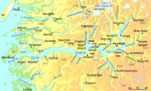
Fjord
Geologically, a fjord is a long, narrow inlet with steep sides or cliffs, created in a valley carved by glacial activity.-Formation:A fjord is formed when a glacier cuts a U-shaped valley by abrasion of the surrounding bedrock. Glacial melting is accompanied by rebound of Earth's crust as the ice...
in Norway
Norway
Norway , officially the Kingdom of Norway, is a Nordic unitary constitutional monarchy whose territory comprises the western portion of the Scandinavian Peninsula, Jan Mayen, and the Arctic archipelago of Svalbard and Bouvet Island. Norway has a total area of and a population of about 4.9 million...
, and the second longest in the world. Located in Sogn og Fjordane
Sogn og Fjordane
is a county in Norway, bordering Møre og Romsdal, Oppland, Buskerud, and Hordaland. The county administration is in the town of Hermansverk in Leikanger municipality while the largest town is Førde....
county, it stretches 205 kilometres (127.4 mi) inland to the small village of Skjolden
Skjolden
Skjolden is a village in the municipality of Luster in Sogn og Fjordane county, Norway. It is located at the end of the Lustrafjord, a branch of the Sognefjord. Skjolden is the innermost point of the Sognefjord, and is the length of the Sognefjord is measured from Skjolden to Ytre Sula island...
. The fjord takes its name from the traditional district
Districts of Norway
The country Norway is historically divided into a number of districts. Many districts have deep historical roots, and only partially coincide with today's administrative units of counties and municipalities. The districts are defined by geographical features, often valleys, mountain ranges, fjords,...
of Sogn
Sogn
Sogn is a traditional district in Western Norway . It is located in the county of Sogn og Fjordane, surrounding the Sognefjord. Sogn consists of the municipalities of Aurland, Balestrand, Hyllestad, Høyanger, Gulen, Leikanger, Luster, Lærdal, Sogndal, Solund, Vik, and Årdal. The district covers ...
.
Geography

Sill (geology)
In geology, a sill is a tabular sheet intrusion that has intruded between older layers of sedimentary rock, beds of volcanic lava or tuff, or even along the direction of foliation in metamorphic rock. The term sill is synonymous with concordant intrusive sheet...
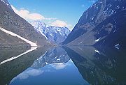
about 100 metres (328.1 ft) below sea level. The average width of the main branch of the Sognefjord is about 4.5 kilometres (2.8 mi). Cliffs surrounding the fjord rise almost sheer from the water to heights of 1000 metres (3,280.8 ft) and more.
The inner end of the Sognefjord is localized southeast of a mountain range rising to about 2000 metres (6,561.7 ft) above sea level and covered by the Jostedalsbreen
Jostedalsbreen
Jostedalsbreen is the largest glacier in continental Europe. It is situated in Sogn og Fjordane county in Western Norway. Jostedalsbreen lies in the municipalities of Luster, Balestrand, Jølster, and Stryn. The highest peak in the area is Lodalskåpa at a height of .Jostedalsbreen has a total area...
, continental Europe
Europe
Europe is, by convention, one of the world's seven continents. Comprising the westernmost peninsula of Eurasia, Europe is generally 'divided' from Asia to its east by the watershed divides of the Ural and Caucasus Mountains, the Ural River, the Caspian and Black Seas, and the waterways connecting...
's largest glacier
Glacier
A glacier is a large persistent body of ice that forms where the accumulation of snow exceeds its ablation over many years, often centuries. At least 0.1 km² in area and 50 m thick, but often much larger, a glacier slowly deforms and flows due to stresses induced by its weight...
. Thus the climate of the inner end of Sognefjord and its branches is not as wet as on the outer coastline.
Smaller fjords which branch off from the Sognefjord include Esefjorden
Esefjorden
Esefjorden is a fjord arm on the north side of the Sognefjord in the municipality of Balestrand in Sogn og Fjordane county, Norway. The fjord is about long. On its south side lies the municipal centre of Balestrand. On the north side is the village of Dragsviki, which has ferry connections to...
, Fjærlandsfjord, Sogndalsfjord, Lustrafjord, Årdalsfjord, Lærdalsfjord, Aurlandsfjord
Aurlandsfjord
Aurlandsfjord is a fjord in Aurland, Vik and Lærdal in Sogn og Fjordane, Norway. It is a branch of Sognefjord; after , the Nærøyfjord branches from it....
, and Nærøyfjord
Nærøyfjord
The Nærøyfjord is a fjord in the municipality of Aurland in Sogn og Fjordane, Norway. The narrow fjord is a branch of the large Sognefjord, and it is featured on the "Norway in a Nutshell" daytrips for tourists...
(which is also a World Heritage Site
World Heritage Site
A UNESCO World Heritage Site is a place that is listed by the UNESCO as of special cultural or physical significance...
).
Lustrafjord
The innermost arm of the Sognefjord is called the Lustrafjord. At its end, there is the village of SkjoldenSkjolden
Skjolden is a village in the municipality of Luster in Sogn og Fjordane county, Norway. It is located at the end of the Lustrafjord, a branch of the Sognefjord. Skjolden is the innermost point of the Sognefjord, and is the length of the Sognefjord is measured from Skjolden to Ytre Sula island...
, which is an access to Jotunheimen National Park. In earlier times, transport from Bergen
Bergen
Bergen is the second largest city in Norway with a population of as of , . Bergen is the administrative centre of Hordaland county. Greater Bergen or Bergen Metropolitan Area as defined by Statistics Norway, has a population of as of , ....
to the Scandinavian inland and vice versa was done by boat from Bergen to Skjolden and from there on a simple road over the highlands.
Tourism
Høyanger
is a municipality in the county of Sogn og Fjordane, Norway. It is located in the traditional district of Sogn. The administrative center is the village of Høyanger, which has 2177 inhabitants . Other villages in Høyanger include Lavik, Kyrkjebø, Austreim, and Vadheim...
, Vik
Vik
Vik is a municipality in the county of Sogn og Fjordane, Norway. It is located in the traditional district of Sogn. The administrative center of Vik is the village of Vikøyri.-General information:...
, Sogndal
Sogndal
Sogndal is a municipality in the county of Sogn og Fjordane, Norway. It is located in the traditional district of Sogn. The village of Sogndalsfjøra is the administrative center of Sogndal municipality. Other main villages include Kaupanger, Kjørnes, and Fjærland...
, Lærdal
Lærdal
Lærdal is a municipality in the southwestern part of Sogn og Fjordane county, Norway. It is part of the traditional district of Sogn. The administrative center of the municipality is the village of Lærdalsøyri...
, Årdal
Årdal
Årdal is a municipality in the county of Sogn og Fjordane, Norway. It is located in the traditional district of Sogn. The village of Årdalstangen is the administrative center of the municipality. Årdal was separated from Lærdal in 1860....
, Gaupne
Gaupne
Gaupne is a village which is the administrative center of the municipality of Luster in Sogn og Fjordane county, Norway. The village has a population of 1,075. The village is located along the Gaupnefjord, an arm of the Lustrafjord, about north of the village of Hafslo. The village of...
, Balestrand
Balestrand
Balestrand is a municipality in the county of Sogn og Fjordane, Norway. It is located in the traditional district of Sogn. The administrative center is the village of Balestrand....
, Gudvangen
Gudvangen
Gudvangen is a village in the municipality of Aurland in Sogn og Fjordane county, Norway. It is a popular tourist destination and is located at the end of the Nærøyfjord where the Nærøydalselvi river empties into the fjord. The highway passes by the village...
, and Flåm
Flåm
Flåm is a village at the inner end of the Aurlandsfjord, an arm of the Sognefjord. The village is located in the municipality of Aurland in Sogn og Fjordane county, Norway...
. Gudvangen
Gudvangen
Gudvangen is a village in the municipality of Aurland in Sogn og Fjordane county, Norway. It is a popular tourist destination and is located at the end of the Nærøyfjord where the Nærøydalselvi river empties into the fjord. The highway passes by the village...
is situated by the Nærøyfjord
Nærøyfjord
The Nærøyfjord is a fjord in the municipality of Aurland in Sogn og Fjordane, Norway. The narrow fjord is a branch of the large Sognefjord, and it is featured on the "Norway in a Nutshell" daytrips for tourists...
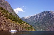
, a branch of the Sognefjord particularly noted for its unspoiled nature and dramatic scenery, and only 300 metres (984.3 ft) across at its narrowest point. The Nærøyfjord is a UNESCO
UNESCO
The United Nations Educational, Scientific and Cultural Organization is a specialized agency of the United Nations...
World Heritage Site
World Heritage Site
A UNESCO World Heritage Site is a place that is listed by the UNESCO as of special cultural or physical significance...
. From Flåm, the Flåm Railway climbs 864 metres (2,834.6 ft) up to Myrdal Station
Myrdal station
Myrdal Station is a mountain railway station and junction, located on the Bergen Line regional mainline in Aurland, Sogn og Fjordane, Norway. The railway station is also the upper terminal of the Flåm Line local railway, which ascends from the valley floor of the Sognefjord to the mountain-top...
in a distance of only 20 kilometres (12.4 mi)—the steepest unassisted railway climb in the world.
Around the inner end of the fjord, three of Norway's famous stave church
Stave church
A stave church is a medieval wooden church with a post and beam construction related to timber framing. The wall frames are filled with vertical planks. The load-bearing posts have lent their name to the building technique...
es have survived: Kaupanger
Kaupanger stave church
Kaupanger Stave Church is the largest stave church in Sogn og Fjordane, and is situated in the town of Kaupanger, Norway. The nave is supported by 22 staves, 8 on each of the longer sides and 3 on each of the shorter. The elevated chancel is carried by 4 free standing staves. The church has the...
and Urnes
Urnes stave church
Urnes Stave Church is a stave church at the Ornes farm, along the Lustrafjord in the municipality of Luster in Sogn og Fjordane county, Norway, about east of the village of Hafslo....
(along the shoreline) and Borgund
Borgund stave church
Borgund Stave Church is a stave church located in Borgund, Lærdal, Norway. It is classified as a triple nave stave church of the so-called Sogn-type. This is also the best preserved of Norway's 28 extant stave churches.-Construction:...
(30 kilometres (18.6 mi) into the Lærdal
Lærdal
Lærdal is a municipality in the southwestern part of Sogn og Fjordane county, Norway. It is part of the traditional district of Sogn. The administrative center of the municipality is the village of Lærdalsøyri...
valley).
The Sognefjord Span
Sognefjord Span
The Sognefjord Spans are the second, third, and fourth longest spans in the world situated east of Hermansverk and are part of different powerlines. As Sognefjord Span is a deep valley the pylons of these spans are not taller than ordinary pylons...
(power lines) crosses the fjord with a span of 4597 metres (15,082 ft). This is the second largest span of power lines in the world. The fjord has become a tourist attraction with summer tourists being an important part of the local economy.
External links
- www.sognefjord.no
- Flåmsbana information
- Powerline information
- Art of the States: Bright Days of Little Sunlight musical work inspired by the Sognefjord