
Bouvet Island
Encyclopedia
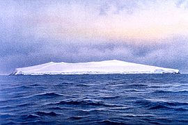
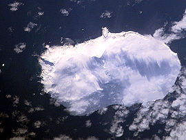
Bouvet Island is an uninhabited Antarctic
volcanic island
in the South Atlantic Ocean
, 2,525 km south-southwest of South Africa
. It is a dependent territory of Norway
and, lying north of 60°S latitude
, is not subject to the Antarctic Treaty. The centre of the island is an ice-filled crater of an inactive volcano
, known as the Wilhelm II Plateau. It is the most remote island in the world.
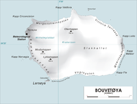 Bouvet Island is located at 54°26′S 3°24′E. It is 49 km² (18.9 sq mi) in area, 93% of which is covered by glacier
s, which block the south and east coasts. A number of rocks and very small satellite islands lie offshore, including Lars Island
to the southwest.
The nearest land is Queen Maud Land
, Antarctica, which is over 1750 kilometres (1,087.4 mi) away to the south, and which does not have a permanent population but is the site of a Norwegian all-year research station
. To the northeast, it is about 2500 kilometres (1,553.4 mi) to Cape Town
.
Bouvet Island has no ports or harbours, only offshore anchorages, and is therefore difficult to approach. Wave action has created a very steep coast. The easiest way to access the island is with a helicopter from a ship. The glaciers form a thick ice layer falling in high cliffs into the sea or onto the black beaches of volcanic sand. The 29.6 kilometres (18.4 mi) of coastline are often surrounded by pack ice. The highest point on the island is called Olavtoppen, and has a peak 780 m (2,559 ft) above sea level. A lava shelf on the island's west coast formed between 1955 and 1958 and provides a nesting site for birds.
Because of the harsh climate and ice-bound terrain, vegetation is limited to lichen
s and moss
es. Seals, seabirds and penguin
s are the only vertebrate
fauna. As such the island is part of the Scotia Sea
Islands tundra
ecoregion
, along with South Georgia and the South Sandwich Islands
, the South Shetland Islands
and the South Orkney Islands
.
Despite being uninhabited, Bouvet Island has the unused Internet
country code
top-level domain
(ccTLD) .bv
. It also has an amateur radio prefix, 3Y, and a few amateur radio
expeditions have travelled to the island to use it. There is no telephone country code or area code, no telephone connection (except through satellite
) and no postal code
nor postal distribution. Bouvet Island is according to Norwegian law in the UTC+01 time zone
.
(Köppen
ET), with temperatures not too far from 0°C all year round.
 Bouvet Island was probably discovered on January 1, 1739, by Jean-Baptiste Charles Bouvet de Lozier
, who commanded the French
ships Aigle and Marie. However, the island's position was not fixed accurately, having been placed eight degrees to the east, and Bouvet did not circumnavigate his discovery, so it remained unknown whether it was an island or part of a continent.
In 1772, Captain James Cook
left South Africa on a mission to find the island. However, when arriving at 54°S 11°E, where Bouvet had said he sighted the island, nothing was to be seen. Captain Cook assumed that Bouvet had taken an iceberg for an island, and he abandoned the search.
The island was not sighted again until 1808, when it was seen by James Lindsay, the captain of the Samuel Enderby & Sons
whaler
Snow Swan. Though he did not land, he was the first to fix the island's position correctly. Since this deviated greatly from the incorrect position previously recorded for Bouvet, it was initially assumed to be a different island and was named Lindsay Island. Only later was it established that Bouvet and Lindsay must be the same.
Captain Benjamin Morrell
of the sealer Wasp claimed to have landed on Bouvet in December 1822 to hunt for seals, but his account is disputed.
On December 10, 1825, Captain Norris, master of the Samuel Enderby & Sons whalers Sprightly and Lively, landed on the island, named it Liverpool Island, and claimed it for the British Crown. Again, it was not known with certainty at the time that this was the same island found previously. He also reported sighting a second island nearby, which he named Thompson Island. No trace of this island now remains.
In 1898, the German
Valdivia expedition of Carl Chun
visited the island but did not land.
The first extended stay on the island was in 1927, when the Norwegian crew of the ship Norvegia stayed for about a month. The island was claimed for Norway
by expedition leader Lars Christensen
on 1 December 1927.
By a Royal Norwegian Decree of January 23, 1928, Bouvet Island (Bouvetøya in Norwegian) became a Norwegian Territory. The United Kingdom
waived its claim in favour of Norway the following year. In 1930 a Norwegian act was passed that made the island a dependent area subject to the sovereignty
of the Kingdom (but not a part of the Kingdom).
In 1964, an abandoned lifeboat
was discovered on the island although its origin has never been determined.
In 1971, Bouvet Island and the adjacent territorial waters were designated a nature reserve. During the 1950s and 1960s, there was some interest from South Africa
to establish a weather station, but conditions were deemed to be too hostile. An automated weather station
was, however, set up in 1977 by the Norwegians.
On September 22, 1979, a satellite
recorded a flash of light (which was later interpreted as having been caused by a nuclear bomb explosion or natural event such as a meteor
) in a stretch of the southern Atlantic Ocean
between Bouvet Island and Prince Edward Islands
. This flash, since dubbed the Vela Incident
, is still not completely resolved.
In 1994, the Norwegians constructed a field station – a container building of 36 square metres (388 sq ft). On October 19, 2007, the Norwegian Polar Institute
announced that the station was no longer visible on satellite photographs. Later investigations indicated that a landslide or ice avalanche swept the building off its foundations. A replacement station is being planned (2009). An unmanned weather station on the island is reportedly still intact.
Antarctic
The Antarctic is the region around the Earth's South Pole, opposite the Arctic region around the North Pole. The Antarctic comprises the continent of Antarctica and the ice shelves, waters and island territories in the Southern Ocean situated south of the Antarctic Convergence...
volcanic island
Island
An island or isle is any piece of sub-continental land that is surrounded by water. Very small islands such as emergent land features on atolls can be called islets, cays or keys. An island in a river or lake may be called an eyot , or holm...
in the South Atlantic Ocean
Atlantic Ocean
The Atlantic Ocean is the second-largest of the world's oceanic divisions. With a total area of about , it covers approximately 20% of the Earth's surface and about 26% of its water surface area...
, 2,525 km south-southwest of South Africa
South Africa
The Republic of South Africa is a country in southern Africa. Located at the southern tip of Africa, it is divided into nine provinces, with of coastline on the Atlantic and Indian oceans...
. It is a dependent territory of Norway
Norway
Norway , officially the Kingdom of Norway, is a Nordic unitary constitutional monarchy whose territory comprises the western portion of the Scandinavian Peninsula, Jan Mayen, and the Arctic archipelago of Svalbard and Bouvet Island. Norway has a total area of and a population of about 4.9 million...
and, lying north of 60°S latitude
60th parallel south
The 60th parallel south is a circle of latitude that is 60 degrees south of the Earth's equatorial plane. No land lies on the parallel—it crosses nothing but ocean...
, is not subject to the Antarctic Treaty. The centre of the island is an ice-filled crater of an inactive volcano
Volcano
2. Bedrock3. Conduit 4. Base5. Sill6. Dike7. Layers of ash emitted by the volcano8. Flank| 9. Layers of lava emitted by the volcano10. Throat11. Parasitic cone12. Lava flow13. Vent14. Crater15...
, known as the Wilhelm II Plateau. It is the most remote island in the world.
Geography
Glacier
A glacier is a large persistent body of ice that forms where the accumulation of snow exceeds its ablation over many years, often centuries. At least 0.1 km² in area and 50 m thick, but often much larger, a glacier slowly deforms and flows due to stresses induced by its weight...
s, which block the south and east coasts. A number of rocks and very small satellite islands lie offshore, including Lars Island
Lars Island
Lars Island is a rocky island, less than 0.2 nautical miles long, which lies just off the southwest extremity of Bouvet Island. First roughly charted in 1898 by a German expedition under Karl Chun. The Norwegian expedition under Captain Harald Horntvedt made a landing on the island from the ship...
to the southwest.
The nearest land is Queen Maud Land
Queen Maud Land
Queen Maud Land is a c. 2.7 million-square-kilometre region of Antarctica claimed as a dependent territory by Norway. The territory lies between 20° west and 45° east, between the British Antarctic Territory to the west and the Australian Antarctic Territory to the east. The latitudinal...
, Antarctica, which is over 1750 kilometres (1,087.4 mi) away to the south, and which does not have a permanent population but is the site of a Norwegian all-year research station
Troll (research station)
Troll is a research station located at Jutulsessen, from the coast in the eastern part of Princess Martha Coast in Queen Maud Land, Antarctica. It is Norway's only all-year research station in Antarctica, and is supplemented by the summer-only station Tor...
. To the northeast, it is about 2500 kilometres (1,553.4 mi) to Cape Town
Cape Town
Cape Town is the second-most populous city in South Africa, and the provincial capital and primate city of the Western Cape. As the seat of the National Parliament, it is also the legislative capital of the country. It forms part of the City of Cape Town metropolitan municipality...
.
Bouvet Island has no ports or harbours, only offshore anchorages, and is therefore difficult to approach. Wave action has created a very steep coast. The easiest way to access the island is with a helicopter from a ship. The glaciers form a thick ice layer falling in high cliffs into the sea or onto the black beaches of volcanic sand. The 29.6 kilometres (18.4 mi) of coastline are often surrounded by pack ice. The highest point on the island is called Olavtoppen, and has a peak 780 m (2,559 ft) above sea level. A lava shelf on the island's west coast formed between 1955 and 1958 and provides a nesting site for birds.
Because of the harsh climate and ice-bound terrain, vegetation is limited to lichen
Lichen
Lichens are composite organisms consisting of a symbiotic organism composed of a fungus with a photosynthetic partner , usually either a green alga or cyanobacterium...
s and moss
Moss
Mosses are small, soft plants that are typically 1–10 cm tall, though some species are much larger. They commonly grow close together in clumps or mats in damp or shady locations. They do not have flowers or seeds, and their simple leaves cover the thin wiry stems...
es. Seals, seabirds and penguin
Penguin
Penguins are a group of aquatic, flightless birds living almost exclusively in the southern hemisphere, especially in Antarctica. Highly adapted for life in the water, penguins have countershaded dark and white plumage, and their wings have become flippers...
s are the only vertebrate
Vertebrate
Vertebrates are animals that are members of the subphylum Vertebrata . Vertebrates are the largest group of chordates, with currently about 58,000 species described. Vertebrates include the jawless fishes, bony fishes, sharks and rays, amphibians, reptiles, mammals, and birds...
fauna. As such the island is part of the Scotia Sea
Scotia Sea
The Scotia Sea is partly in the Southern Ocean and mostly in the South Atlantic Ocean.-Location and description:Habitually stormy and cold, the Scotia Sea is the area of water between Tierra del Fuego, South Georgia, South Sandwich Islands, South Orkney Islands and the Antarctic Peninsula, and...
Islands tundra
Tundra
In physical geography, tundra is a biome where the tree growth is hindered by low temperatures and short growing seasons. The term tundra comes through Russian тундра from the Kildin Sami word tūndâr "uplands," "treeless mountain tract." There are three types of tundra: Arctic tundra, alpine...
ecoregion
Ecoregion
An ecoregion , sometimes called a bioregion, is an ecologically and geographically defined area that is smaller than an ecozone and larger than an ecosystem. Ecoregions cover relatively large areas of land or water, and contain characteristic, geographically distinct assemblages of natural...
, along with South Georgia and the South Sandwich Islands
South Georgia and the South Sandwich Islands
South Georgia and the South Sandwich Islands is a British overseas territory and overseas territory of the European Union in the southern Atlantic Ocean. It is a remote and inhospitable collection of islands, consisting of South Georgia and a chain of smaller islands, known as the South Sandwich...
, the South Shetland Islands
South Shetland Islands
The South Shetland Islands are a group of Antarctic islands, lying about north of the Antarctic Peninsula, with a total area of . By the Antarctic Treaty of 1959, the Islands' sovereignty is neither recognized nor disputed by the signatories and they are free for use by any signatory for...
and the South Orkney Islands
South Orkney Islands
The South Orkney Islands are a group of islands in the Southern Ocean, about north-east of the tip of the Antarctic Peninsula. They have a total area of about ....
.
Despite being uninhabited, Bouvet Island has the unused Internet
Internet
The Internet is a global system of interconnected computer networks that use the standard Internet protocol suite to serve billions of users worldwide...
country code
Country code
Country codes are short alphabetic or numeric geographical codes developed to represent countries and dependent areas, for use in data processing and communications. Several different systems have been developed to do this. The best known of these is ISO 3166-1...
top-level domain
Top-level domain
A top-level domain is one of the domains at the highest level in the hierarchical Domain Name System of the Internet. The top-level domain names are installed in the root zone of the name space. For all domains in lower levels, it is the last part of the domain name, that is, the last label of a...
(ccTLD) .bv
.bv
.bv is the Internet country code top-level domain reserved for the uninhabited Norwegian dependent territory of Bouvet Island. The domain name registry and sponsor is Norid, but .bv is not open for registration. .bv was designated on 21 August 1997 and was placed under the .no registry Norid...
. It also has an amateur radio prefix, 3Y, and a few amateur radio
Amateur radio
Amateur radio is the use of designated radio frequency spectrum for purposes of private recreation, non-commercial exchange of messages, wireless experimentation, self-training, and emergency communication...
expeditions have travelled to the island to use it. There is no telephone country code or area code, no telephone connection (except through satellite
Communications satellite
A communications satellite is an artificial satellite stationed in space for the purpose of telecommunications...
) and no postal code
Postal code
A postal code is a series of letters and/or digits appended to a postal address for the purpose of sorting mail. Once postal codes were introduced, other applications became possible.In February 2005, 117 of the 190 member countries of the Universal Postal Union had postal code systems...
nor postal distribution. Bouvet Island is according to Norwegian law in the UTC+01 time zone
Time zone
A time zone is a region on Earth that has a uniform standard time for legal, commercial, and social purposes. In order for the same clock time to always correspond to the same portion of the day as the Earth rotates , different places on the Earth need to have different clock times...
.
Climate
Bouvetoya has an ocean-moderated polar climatePolar climate
Regions with a polar climate are characterized by a lack of warm summers . Regions with polar climate cover over 20% of the Earth. The sun shines 24 hours in the summer, and barely ever shines at all in the winter...
(Köppen
Köppen climate classification
The Köppen climate classification is one of the most widely used climate classification systems. It was first published by Crimea German climatologist Wladimir Köppen in 1884, with several later modifications by Köppen himself, notably in 1918 and 1936...
ET), with temperatures not too far from 0°C all year round.
History
Jean-Baptiste Charles Bouvet de Lozier
Jean Baptiste Charles Bouvet de Lozier was a French sailor, explorer, and governor of the Mascarene Islands.He was orphaned at the age of seven and after having been educated in Paris, he was sent to Saint Malo to study navigation. He became a lieutenant of the French East India Company in 1731...
, who commanded the French
France
The French Republic , The French Republic , The French Republic , (commonly known as France , is a unitary semi-presidential republic in Western Europe with several overseas territories and islands located on other continents and in the Indian, Pacific, and Atlantic oceans. Metropolitan France...
ships Aigle and Marie. However, the island's position was not fixed accurately, having been placed eight degrees to the east, and Bouvet did not circumnavigate his discovery, so it remained unknown whether it was an island or part of a continent.
In 1772, Captain James Cook
James Cook
Captain James Cook, FRS, RN was a British explorer, navigator and cartographer who ultimately rose to the rank of captain in the Royal Navy...
left South Africa on a mission to find the island. However, when arriving at 54°S 11°E, where Bouvet had said he sighted the island, nothing was to be seen. Captain Cook assumed that Bouvet had taken an iceberg for an island, and he abandoned the search.
The island was not sighted again until 1808, when it was seen by James Lindsay, the captain of the Samuel Enderby & Sons
Samuel Enderby & Sons
Samuel Enderby & Sons was a whaling and sealing company based in London, England, founded circa 1775 by Samuel Enderby . The company encouraged their captains to combine exploration with their business activities, and sponsored several of the earliest expeditions to the subantarctic, Southern Ocean...
whaler
Whaler
A whaler is a specialized ship, designed for whaling, the catching and/or processing of whales. The former included the whale catcher, a steam or diesel-driven vessel with a harpoon gun mounted at its bows. The latter included such vessels as the sail or steam-driven whaleship of the 16th to early...
Snow Swan. Though he did not land, he was the first to fix the island's position correctly. Since this deviated greatly from the incorrect position previously recorded for Bouvet, it was initially assumed to be a different island and was named Lindsay Island. Only later was it established that Bouvet and Lindsay must be the same.
Captain Benjamin Morrell
Benjamin Morrell
Benjamin Morrell was an American sealing captain and explorer who between 1823 and 1831 made a series of voyages, mainly to the Southern Ocean and the Pacific Islands, which are recorded in a colourful memoir A Narrative of Four Voyages...
of the sealer Wasp claimed to have landed on Bouvet in December 1822 to hunt for seals, but his account is disputed.
On December 10, 1825, Captain Norris, master of the Samuel Enderby & Sons whalers Sprightly and Lively, landed on the island, named it Liverpool Island, and claimed it for the British Crown. Again, it was not known with certainty at the time that this was the same island found previously. He also reported sighting a second island nearby, which he named Thompson Island. No trace of this island now remains.
In 1898, the German
Germany
Germany , officially the Federal Republic of Germany , is a federal parliamentary republic in Europe. The country consists of 16 states while the capital and largest city is Berlin. Germany covers an area of 357,021 km2 and has a largely temperate seasonal climate...
Valdivia expedition of Carl Chun
Carl Chun
Dr. Carl Chun was a German marine biologist.Chun was born in Höchst, today a part of Frankfurt, and studied zoology at the University of Leipzig where, after posts in Königsberg and Breslau, he was appointed professor for biology in 1892...
visited the island but did not land.
The first extended stay on the island was in 1927, when the Norwegian crew of the ship Norvegia stayed for about a month. The island was claimed for Norway
Norway
Norway , officially the Kingdom of Norway, is a Nordic unitary constitutional monarchy whose territory comprises the western portion of the Scandinavian Peninsula, Jan Mayen, and the Arctic archipelago of Svalbard and Bouvet Island. Norway has a total area of and a population of about 4.9 million...
by expedition leader Lars Christensen
Lars Christensen
Lars Christensen was a Norwegian shipowner and whaling magnate with a keen interest in the exploration of Antarctica.-Career:...
on 1 December 1927.
By a Royal Norwegian Decree of January 23, 1928, Bouvet Island (Bouvetøya in Norwegian) became a Norwegian Territory. The United Kingdom
United Kingdom
The United Kingdom of Great Britain and Northern IrelandIn the United Kingdom and Dependencies, other languages have been officially recognised as legitimate autochthonous languages under the European Charter for Regional or Minority Languages...
waived its claim in favour of Norway the following year. In 1930 a Norwegian act was passed that made the island a dependent area subject to the sovereignty
Sovereignty
Sovereignty is the quality of having supreme, independent authority over a geographic area, such as a territory. It can be found in a power to rule and make law that rests on a political fact for which no purely legal explanation can be provided...
of the Kingdom (but not a part of the Kingdom).
In 1964, an abandoned lifeboat
Lifeboat (rescue)
A rescue lifeboat is a boat rescue craft which is used to attend a vessel in distress, or its survivors, to rescue crewmen and passengers. It can be hand pulled, sail powered or powered by an engine...
was discovered on the island although its origin has never been determined.
In 1971, Bouvet Island and the adjacent territorial waters were designated a nature reserve. During the 1950s and 1960s, there was some interest from South Africa
South Africa
The Republic of South Africa is a country in southern Africa. Located at the southern tip of Africa, it is divided into nine provinces, with of coastline on the Atlantic and Indian oceans...
to establish a weather station, but conditions were deemed to be too hostile. An automated weather station
Weather station
A weather station is a facility, either on land or sea, with instruments and equipment for observing atmospheric conditions to provide information for weather forecasts and to study the weather and climate. The measurements taken include temperature, barometric pressure, humidity, wind speed, wind...
was, however, set up in 1977 by the Norwegians.
On September 22, 1979, a satellite
Satellite
In the context of spaceflight, a satellite is an object which has been placed into orbit by human endeavour. Such objects are sometimes called artificial satellites to distinguish them from natural satellites such as the Moon....
recorded a flash of light (which was later interpreted as having been caused by a nuclear bomb explosion or natural event such as a meteor
METEOR
METEOR is a metric for the evaluation of machine translation output. The metric is based on the harmonic mean of unigram precision and recall, with recall weighted higher than precision...
) in a stretch of the southern Atlantic Ocean
Atlantic Ocean
The Atlantic Ocean is the second-largest of the world's oceanic divisions. With a total area of about , it covers approximately 20% of the Earth's surface and about 26% of its water surface area...
between Bouvet Island and Prince Edward Islands
Prince Edward Islands
The Prince Edward Islands are two small islands in the sub-antarctic Indian Ocean that are part of South Africa. The islands, named Marion Island and Prince Edward Island, are located at ....
. This flash, since dubbed the Vela Incident
Vela Incident
The Vela Incident was an unidentified "double flash" of light that was detected by an American Vela Hotel satellite on September 22, 1979....
, is still not completely resolved.
In 1994, the Norwegians constructed a field station – a container building of 36 square metres (388 sq ft). On October 19, 2007, the Norwegian Polar Institute
Norwegian Polar Institute
The Norwegian Polar Institute is Norway's national institution for polar research. It is run under the auspices of the Norwegian Ministry of Environment. The institute organizes expeditions to the Arctic and Antarctic regions and runs a research station at Ny-Ålesund...
announced that the station was no longer visible on satellite photographs. Later investigations indicated that a landslide or ice avalanche swept the building off its foundations. A replacement station is being planned (2009). An unmanned weather station on the island is reportedly still intact.
Fiction
- Bouvet is the setting of the 2004 movie Alien vs. PredatorAlien vs. Predator (film)Alien vs. Predator is a 2004 American science fiction film directed by Paul W. S. Anderson for 20th Century Fox and starring Sanaa Lathan and Lance Henriksen. The film adapts the Alien vs. Predator crossover imprint bringing together the eponymous creatures of the Alien and Predator series, a...
, in which it is referred to using its Norwegian name "Bouvetøya" even though in the unrated edition of the film, a satellite focuses in on the island which is geographically situated in the approximate location of Peter I IslandPeter I IslandPeter I Island is an uninhabited volcanic island in the Bellingshausen Sea, from Antarctica. It is claimed as a dependency of Norway, and along with Queen Maud Land and Bouvet Island comprises one of the three Norwegian dependent territories in the Antarctic and sub-Antarctic. Peter I Island is ...
. - The island figures prominently in the book A Grue of Ice (published in the US as The Disappearing Island), an adventure novel based on Tristan da Cunha, Bouvet, and the mythical Thompson Island, by Geoffrey JenkinsGeoffrey Jenkins-Early life:Jenkins was born Pretoria. At the age of 17 he wrote and had published A Century of History which received a special eulogy from General Jan Smuts at the centenary of Potchefstroom....
. - Bouvet features in the novel Warhead by Andy RemicAndy RemicAndy Remic is a UK born author of thrillers, science fiction and military science fiction. His first three novels, Spiral , Quake and Warhead were published by Orbit Books...
. - Bouvet features in the novel Batmans Schönheit by Heinrich SteinfestHeinrich SteinfestHeinrich Steinfest is an multiple award-winning Austrian writer of crime novels, born in Australia. Two years after his birth, his emigrant parents moved back to their native Vienna where he lived until moving to Stuttgart a few years ago.His novels contain bizarre examples of events that...
.
See also
- .bv.bv.bv is the Internet country code top-level domain reserved for the uninhabited Norwegian dependent territory of Bouvet Island. The domain name registry and sponsor is Norid, but .bv is not open for registration. .bv was designated on 21 August 1997 and was placed under the .no registry Norid...
(Internet top-domain code for Bouvet Island) - ISO 3166-2:BVISO 3166-2:BVISO 3166-2:BV is the entry for Bouvet Island in ISO 3166-2, part of the ISO 3166 standard published by the International Organization for Standardization , which defines codes for the names of the principal subdivisions of all countries coded in ISO 3166-1.Currently no ISO 3166-2 codes are defined...
, an ISO country code standard - List of islands of Norway
- Sub-antarctic islands
External links
- Satellite map of Bouvet Island on BlooSeeBlooseeBlooSee is a social network and an ocean web mapping site where sailors, divers, surfers and other sea lovers geotag and share information and knowledge about the oceans. BlooSee is built in Python and uses the Google Maps API.BlooSee is owned by BlooSee, Inc...
- Information on Bouvet Island
- Bouvet Island - Bouvetøya
- Investigation into Bouvet's abandoned lifeboat mystery
- Bouvet Island at Infoplease
- 2000 Bouvet Island amateur radio expedition (3YØC)
- 1990 Bouvet Island amateur radio expedition (3Y5X)