

Orographic lift
Encyclopedia
Air mass
In meteorology, an air mass is a volume of air defined by its temperature and water vapor content. Air masses cover many hundreds or thousands of square miles, and adopt the characteristics of the surface below them. They are classified according to latitude and their continental or maritime...
is forced from a low elevation
Elevation
The elevation of a geographic location is its height above a fixed reference point, most commonly a reference geoid, a mathematical model of the Earth's sea level as an equipotential gravitational surface ....
to a higher elevation as it moves over rising terrain. As the air mass gains altitude
Altitude
Altitude or height is defined based on the context in which it is used . As a general definition, altitude is a distance measurement, usually in the vertical or "up" direction, between a reference datum and a point or object. The reference datum also often varies according to the context...
it quickly cools down adiabatically, which can raise the relative humidity
Relative humidity
Relative humidity is a term used to describe the amount of water vapor in a mixture of air and water vapor. It is defined as the partial pressure of water vapor in the air-water mixture, given as a percentage of the saturated vapor pressure under those conditions...
to 100% and create cloud
Cloud
A cloud is a visible mass of liquid droplets or frozen crystals made of water and/or various chemicals suspended in the atmosphere above the surface of a planetary body. They are also known as aerosols. Clouds in Earth's atmosphere are studied in the cloud physics branch of meteorology...
s and, under the right conditions, precipitation
Precipitation (meteorology)
In meteorology, precipitation In meteorology, precipitation In meteorology, precipitation (also known as one of the classes of hydrometeors, which are atmospheric water phenomena is any product of the condensation of atmospheric water vapor that falls under gravity. The main forms of precipitation...
.
Precipitation
Precipitation induced by orographic lift occurs in many places throughout the world. Examples include:- The mountains near Baja California North - specifically La Bocana to Laguna Hanson.
- The windward slopes of Khasi and Jayantia Hills see over 11000 mm (see MawsynramMawsynramMawsynram is a village in the East Khasi Hills district of Meghalaya state in north-eastern India, 56 kilometers from Shillong. It is reportedly the wettest place on Earth, with an annual rainfall of...
) of rain during the Southwest Monsoon Season - The Western GhatsWestern GhatsThe Western Ghats, Western Ghauts or the Sahyādri is a mountain range along the western side of India. It runs north to south along the western edge of the Deccan Plateau, and separates the plateau from a narrow coastal plain along the Arabian Sea. The Western Ghats block rainfall to the Deccan...
that run along India's western coast. - The Great Dividing RangeGreat Dividing RangeThe Great Dividing Range, or the Eastern Highlands, is Australia's most substantial mountain range and the third longest in the world. The range stretches more than 3,500 km from Dauan Island off the northeastern tip of Queensland, running the entire length of the eastern coastline through...
of Eastern and South Eastern Australia which forces uplift of moist air originating from the ocean to the east. - The mountains of New ZealandNew ZealandNew Zealand is an island country in the south-western Pacific Ocean comprising two main landmasses and numerous smaller islands. The country is situated some east of Australia across the Tasman Sea, and roughly south of the Pacific island nations of New Caledonia, Fiji, and Tonga...
, which faces a prevailing westerly flow off the Tasman SeaTasman SeaThe Tasman Sea is the large body of water between Australia and New Zealand, approximately across. It extends 2,800 km from north to south. It is a south-western segment of the South Pacific Ocean. The sea was named after the Dutch explorer Abel Janszoon Tasman, the first recorded European...
. - The mountainous western coastal regions of TasmaniaTasmaniaTasmania is an Australian island and state. It is south of the continent, separated by Bass Strait. The state includes the island of Tasmania—the 26th largest island in the world—and the surrounding islands. The state has a population of 507,626 , of whom almost half reside in the greater Hobart...
which also face a prevailing westerly flow. - The southern AndesAndesThe Andes is the world's longest continental mountain range. It is a continual range of highlands along the western coast of South America. This range is about long, about to wide , and of an average height of about .Along its length, the Andes is split into several ranges, which are separated...
, which faces a prevailing westerly flow off the Pacific OceanPacific OceanThe Pacific Ocean is the largest of the Earth's oceanic divisions. It extends from the Arctic in the north to the Southern Ocean in the south, bounded by Asia and Australia in the west, and the Americas in the east.At 165.2 million square kilometres in area, this largest division of the World...
. - The Northwestern United StatesNorthwestern United StatesThe Northwestern United States comprise the northwestern states up to the western Great Plains regions of the United States, and consistently include the states of Oregon, Washington, Idaho, Montana, Wyoming, to which part of southeast Alaska is also sometimes included...
and CanadaCanadaCanada is a North American country consisting of ten provinces and three territories. Located in the northern part of the continent, it extends from the Atlantic Ocean in the east to the Pacific Ocean in the west, and northward into the Arctic Ocean...
(OregonOregonOregon is a state in the Pacific Northwest region of the United States. It is located on the Pacific coast, with Washington to the north, California to the south, Nevada on the southeast and Idaho to the east. The Columbia and Snake rivers delineate much of Oregon's northern and eastern...
, Washington, British ColumbiaBritish ColumbiaBritish Columbia is the westernmost of Canada's provinces and is known for its natural beauty, as reflected in its Latin motto, Splendor sine occasu . Its name was chosen by Queen Victoria in 1858...
, and Southern AlaskaAlaskaAlaska is the largest state in the United States by area. It is situated in the northwest extremity of the North American continent, with Canada to the east, the Arctic Ocean to the north, and the Pacific Ocean to the west and south, with Russia further west across the Bering Strait...
) see prevailing westerly flow off the northern Pacific OceanPacific OceanThe Pacific Ocean is the largest of the Earth's oceanic divisions. It extends from the Arctic in the north to the Southern Ocean in the south, bounded by Asia and Australia in the west, and the Americas in the east.At 165.2 million square kilometres in area, this largest division of the World...
. Places on the sea-facing side of coastal mountains see in excess of 140 inches (over 3.5 m) of precipitationPrecipitation (meteorology)In meteorology, precipitation In meteorology, precipitation In meteorology, precipitation (also known as one of the classes of hydrometeors, which are atmospheric water phenomena is any product of the condensation of atmospheric water vapor that falls under gravity. The main forms of precipitation...
per year. These locales are on the side of the mountainMountainImage:Himalaya_annotated.jpg|thumb|right|The Himalayan mountain range with Mount Everestrect 58 14 160 49 Chomo Lonzorect 200 28 335 52 Makalurect 378 24 566 45 Mount Everestrect 188 581 920 656 Tibetan Plateaurect 250 406 340 427 Rong River...
s which are in the path of stormStormA storm is any disturbed state of an astronomical body's atmosphere, especially affecting its surface, and strongly implying severe weather...
systems, and therefore receive the moisture which is effectively squeezed from the clouds. - The ski countrySki countrySki country is a term used to describe portions of the boundary between the Niagara Frontier and the Southern Tier of the western part of New York.-Weather:...
region of New YorkNew YorkNew York is a state in the Northeastern region of the United States. It is the nation's third most populous state. New York is bordered by New Jersey and Pennsylvania to the south, and by Connecticut, Massachusetts and Vermont to the east...
and PennsylvaniaPennsylvaniaThe Commonwealth of Pennsylvania is a U.S. state that is located in the Northeastern and Mid-Atlantic regions of the United States. The state borders Delaware and Maryland to the south, West Virginia to the southwest, Ohio to the west, New York and Ontario, Canada, to the north, and New Jersey to...
, particularly with lake effect snowLake effect snowLake-effect snow is produced during cooler atmospheric conditions when cold winds move across long expanses of warmer lake water, providing energy and picking up water vapor which freezes and is deposited on the leeward shores...
s. - Transylvania County, North CarolinaTransylvania County, North CarolinaTransylvania County is a county located in the U.S. state of North Carolina. As of 2010, the population was 33,090. Its county seat is Brevard.- History :The county was formed in 1861 from parts of Henderson County and Jackson County...
, which gets the most rainfall of anywhere in the Eastern U.S. (90 inches). - Appalachian MountainsAppalachian MountainsThe Appalachian Mountains #Whether the stressed vowel is or ,#Whether the "ch" is pronounced as a fricative or an affricate , and#Whether the final vowel is the monophthong or the diphthong .), often called the Appalachians, are a system of mountains in eastern North America. The Appalachians...
in West VirginiaWest VirginiaWest Virginia is a state in the Appalachian and Southeastern regions of the United States, bordered by Virginia to the southeast, Kentucky to the southwest, Ohio to the northwest, Pennsylvania to the northeast and Maryland to the east...
(particularly the western facing slopes). - The Eastern seaboard ofEcoregions of MadagascarMadagascar island, located in the Indian Ocean off the east coast of Africa, is the fourth largest island in the world. Its long isolation from neighbouring continents allowed the evolution of distinct communities of plants and animals. It is home to five percent of the world's plant and animal...
MadagascarMadagascarThe Republic of Madagascar is an island country located in the Indian Ocean off the southeastern coast of Africa...
. - Table MountainTable MountainTable Mountain is a flat-topped mountain forming a prominent landmark overlooking the city of Cape Town in South Africa, and is featured in the flag of Cape Town and other local government insignia. It is a significant tourist attraction, with many visitors using the cableway or hiking to the top...
, Cape TownCape TownCape Town is the second-most populous city in South Africa, and the provincial capital and primate city of the Western Cape. As the seat of the National Parliament, it is also the legislative capital of the country. It forms part of the City of Cape Town metropolitan municipality...
, South AfricaSouth AfricaThe Republic of South Africa is a country in southern Africa. Located at the southern tip of Africa, it is divided into nine provinces, with of coastline on the Atlantic and Indian oceans...
. The cold Atlantic air mass flows up over the north western face to 3500 feet above sea level and is met by the warm Indian Ocean air mass from the south eastern back side of the mountain forming the famous "Table Cloth".
Rain shadowing
The highest precipitation amounts are found slightly upwind from the prevailing winds at the crests of mountain ranges, where they relieve and therefore the upward lifting is greatest. As the air descends the lee side of the mountain, it warms and dries, creating a rain shadow. On the lee side of the mountains, sometimes as little as 15 miles (25 km) away from high precipitation zones, annual precipitationPrecipitation (meteorology)
In meteorology, precipitation In meteorology, precipitation In meteorology, precipitation (also known as one of the classes of hydrometeors, which are atmospheric water phenomena is any product of the condensation of atmospheric water vapor that falls under gravity. The main forms of precipitation...
can be as low as 8 inches (200 mm) per year.
- The HimalayasHimalayasThe Himalaya Range or Himalaya Mountains Sanskrit: Devanagari: हिमालय, literally "abode of snow"), usually called the Himalayas or Himalaya for short, is a mountain range in Asia, separating the Indian subcontinent from the Tibetan Plateau...
block moisture from the Tibetan PlateauTibetan PlateauThe Tibetan Plateau , also known as the Qinghai–Tibetan Plateau is a vast, elevated plateau in Central Asia covering most of the Tibet Autonomous Region and Qinghai, in addition to smaller portions of western Sichuan, southwestern Gansu, and northern Yunnan in Western China and Ladakh in... - The Atacama DesertAtacama DesertThe Atacama Desert is a plateau in South America, covering a strip of land on the Pacific coast, west of the Andes mountains. It is, according to NASA, National Geographic and many other publications, the driest desert in the world...
in PeruPeruPeru , officially the Republic of Peru , is a country in western South America. It is bordered on the north by Ecuador and Colombia, on the east by Brazil, on the southeast by Bolivia, on the south by Chile, and on the west by the Pacific Ocean....
and ChileChileChile ,officially the Republic of Chile , is a country in South America occupying a long, narrow coastal strip between the Andes mountains to the east and the Pacific Ocean to the west. It borders Peru to the north, Bolivia to the northeast, Argentina to the east, and the Drake Passage in the far... - SwitzerlandSwitzerlandSwitzerland name of one of the Swiss cantons. ; ; ; or ), in its full name the Swiss Confederation , is a federal republic consisting of 26 cantons, with Bern as the seat of the federal authorities. The country is situated in Western Europe,Or Central Europe depending on the definition....
's Rhone valleyRhône RiverThe Rhone is one of the major rivers of Europe, rising in Switzerland and running from there through southeastern France. At Arles, near its mouth on the Mediterranean Sea, the river divides into two branches, known as the Great Rhone and the Little Rhone... - Areas east of the Cascade RangeCascade RangeThe Cascade Range is a major mountain range of western North America, extending from southern British Columbia through Washington and Oregon to Northern California. It includes both non-volcanic mountains, such as the North Cascades, and the notable volcanoes known as the High Cascades...
in the Pacific Northwest (Washington and OregonOregonOregon is a state in the Pacific Northwest region of the United States. It is located on the Pacific coast, with Washington to the north, California to the south, Nevada on the southeast and Idaho to the east. The Columbia and Snake rivers delineate much of Oregon's northern and eastern...
) - Areas east of the Olympic MountainsOlympic MountainsThe Olympic Mountains is a mountain range on the Olympic Peninsula of western Washington in the United States. The mountains, part of the Pacific Coast Ranges, are not especially high - Mount Olympus is the highest at - but the western slopes of the Olympics rise directly out of the Pacific...
in Washington state - The Great BasinGreat BasinThe Great Basin is the largest area of contiguous endorheic watersheds in North America and is noted for its arid conditions and Basin and Range topography that varies from the North American low point at Badwater Basin to the highest point of the contiguous United States, less than away at the...
of the United States, east of the Sierra Nevada- Geography of the United States Pacific Mountain System
- Pacific CordilleraPacific CordilleraThe Pacific Cordillera is a top-level physiographic region of Canada. This cordillera is part of the Western Cordillera of North America. The mountain ranges in this region were covered during the Pleistocene by the Cordilleran Ice Sheet...
- CaliforniaCaliforniaCalifornia is a state located on the West Coast of the United States. It is by far the most populous U.S. state, and the third-largest by land area...
's Central Valley - The Canadian PrairiesCanadian PrairiesThe Canadian Prairies is a region of Canada, specifically in western Canada, which may correspond to several different definitions, natural or political. Notably, the Prairie provinces or simply the Prairies comprise the provinces of Alberta, Saskatchewan, and Manitoba, as they are largely covered...
- The HawaiiHawaiiHawaii is the newest of the 50 U.S. states , and is the only U.S. state made up entirely of islands. It is the northernmost island group in Polynesia, occupying most of an archipelago in the central Pacific Ocean, southwest of the continental United States, southeast of Japan, and northeast of...
an island of KauaiKauaiKauai or Kauai, known as Tauai in the ancient Kaua'i dialect, is geologically the oldest of the main Hawaiian Islands. With an area of , it is the fourth largest of the main islands in the Hawaiian archipelago, and the 21st largest island in the United States. Known also as the "Garden Isle",... - North East England is in the rain shadow of the Pennines, this combined with Britain's previaling wind from the South West. This explains the significant differences between the rainfall in the North West and North East.
- The Judean DesertJudean desertThe Judaean Desert is a desert in Israel and the West Bank that lies east of Jerusalem and descends to the Dead Sea. It stretches from the northeastern Negev to the east of Beit El, and is marked by terraces with escarpments. It ends in a steep escarpment dropping to the Dead Sea and the Jordan...
in the Land of Israel and the Dead SeaDead SeaThe Dead Sea , also called the Salt Sea, is a salt lake bordering Jordan to the east and Israel and the West Bank to the west. Its surface and shores are below sea level, the lowest elevation on the Earth's surface. The Dead Sea is deep, the deepest hypersaline lake in the world...
.
Leeward winds
Downslope winds occur on the leeward side of mountain barriers when a stable air mass is carried over the mountain by strong winds that increase in strength with height. Moisture is removed and latent heat released as the air mass is orographically lifted. As the air mass descends, it is compression heated. The warm foehn wind, locally known as the Chinook windChinook wind
Chinook winds , often called chinooks, commonly refers to foehn winds in the interior West of North America, where the Canadian Prairies and Great Plains meet various mountain ranges, although the original usage is in reference to wet, warm coastal winds in the Pacific Northwest.Chinook is claimed...
, Bergwind
Bergwind
Bergwind is the South African name for a foehn wind, a hot dry wind blowing from the mountainous interior to the coast. It varies from mild to gusts up to 100km/h that cause structural damage...
or Diablo wind
Diablo wind
Diablo wind is a name that has been occasionally used for the hot, dry offshore wind from the northeast that typically occurs in the San Francisco Bay Area of Northern California during the spring and fall. The same wind pattern also affects other parts of California's coastal ranges...
or Nor'wester
Nor'west arch
The Nor'west arch is a weather pattern peculiar to the east coast of New Zealand's South Island. For this reason, it is also often referred to as the Canterbury arch. It is shown in an apparent arch of high white cloud in an otherwise clear blue sky over the Southern Alps, and is accompanied by a...
depending on the region, provide examples of this type of wind, and are driven in part by latent heat released by orographic-lifting-induced precipitation.
A similar class of winds, the Sirocco
Sirocco
Sirocco, scirocco, , jugo or, rarely, siroc is a Mediterranean wind that comes from the Sahara and reaches hurricane speeds in North Africa and Southern Europe. It is known in North Africa by the Arabic word qibli or ghibli Sirocco, scirocco, , jugo or, rarely, siroc is a Mediterranean wind...
, the Bora
Bora
-Performers:* Bora, a Korean pop artist in the group Sistar* Bora Yoon, experimental sound artist and composer / performer based in NYC-Geography:...
and Santa Ana wind
Santa Ana wind
The Santa Ana winds are strong, extremely dry offshore winds that characteristically sweep through Southern California and northern Baja California in late fall and winter. They can range from hot to cold, depending on the prevailing temperatures in the source regions, the Great Basin and upper...
s, are examples where orographic lifting has limited effect since there is limited moisture to remove in the Sahara
Sahara
The Sahara is the world's second largest desert, after Antarctica. At over , it covers most of Northern Africa, making it almost as large as Europe or the United States. The Sahara stretches from the Red Sea, including parts of the Mediterranean coasts, to the outskirts of the Atlantic Ocean...
n or other air masses; the Sirocco, Bora and Santa Ana are driven primarily by (adiabatic) compression heating.
Associated clouds
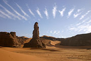
As air flows over mountain barriers, orographic lift can create a variety of cloud effects.- Orographic fog is formed as the air rises up the slope and will often envelope the summit. When the air is humid, some of the moisture will fall on the windward slope and on the summit of the mountain.
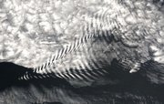
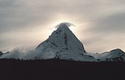
- When there is a high wind, a banner cloud is formed downwind of the upper slopes of isolated, steep-sided mountains. This cloud is similar to the condensation observed off the tips of high-performance aircraft wings when they operate in humid conditions; it is created by the vorticesVortexA vortex is a spinning, often turbulent,flow of fluid. Any spiral motion with closed streamlines is vortex flow. The motion of the fluid swirling rapidly around a center is called a vortex...
and local uplifting in the air caused by the orographic lifting as the wind passes the mountain. The most famous such cloud forms routinely in the lee of the MatterhornMatterhornThe Matterhorn , Monte Cervino or Mont Cervin , is a mountain in the Pennine Alps on the border between Switzerland and Italy. Its summit is 4,478 metres high, making it one of the highest peaks in the Alps. The four steep faces, rising above the surrounding glaciers, face the four compass points...
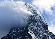
. - The leeward edge of an extensive mass of orographic clouds may be quite distinct. On the leeward side of the mountain, the air flowing downward is known as a foehn wind. Because some of the moisture has condensed on the top of the mountain, the foehn (or föhn) is drier, so any suspended moisture quickly evaporates as the air descends.The distinct cut-off line which forms along and parallel to the ridge line is sometimes known as a foehn wall (or föhn wall). This is because the edge appears stationary and it often appears to have an abrupt wall-like edge. A foehn wall is a common feature along the Front Range
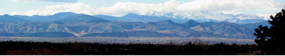 Front RangeThe Front Range is a mountain range of the Southern Rocky Mountains of North America located in the north-central portion of the U.S. State of Colorado and southeastern portion of the U.S. State of Wyoming. It is the first mountain range encountered moving west along the 40th parallel north across...
of the ColoradoColoradoColorado is a U.S. state that encompasses much of the Rocky Mountains as well as the northeastern portion of the Colorado Plateau and the western edge of the Great Plains...
RockiesRocky MountainsThe Rocky Mountains are a major mountain range in western North America. The Rocky Mountains stretch more than from the northernmost part of British Columbia, in western Canada, to New Mexico, in the southwestern United States...
. - A Rotor cloud is sometimes formed downwind and below the level of the ridge. It has the appearance of the ragged cumulusCumulus cloudCumulus clouds are a type of cloud with noticeable vertical development and clearly defined edges. Cumulus means "heap" or "pile" in Latin. They are often described as "puffy" or "cotton-like" in appearance. Cumulus clouds may appear alone, in lines, or in clusters...
cloud type but it is caused by a turbulent horizontal vortex, i.e. the air is very rough.
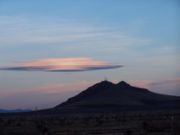
- Lenticular cloudLenticular cloudLenticular clouds are stationary lens-shaped clouds that form at high altitudes, normally aligned perpendicular to the wind direction. Lenticular clouds can be separated into altocumulus standing lenticularis , stratocumulus standing lenticular , and cirrocumulus standing lenticular...
s are stationary lens-shaped clouds that are formed downwind of mountains by lee wavesLee wavesIn meteorology, lee waves are atmospheric standing waves. The most common form is mountain waves, which are atmospheric internal gravity waves...
if the air mass is close to the dew point. They are normally aligned at right-angles to the wind direction and are formed at altitudes up to 12000 metres (39,370 ft).
- A cap cloud is a special form of the lenticular cloud with a base low enough that it forms around and covers the peak, capping it.
- A chinook arch cloud is an extensive wave cloud. It has this special name in North America where it is associated with the Chinook windChinook windChinook winds , often called chinooks, commonly refers to foehn winds in the interior West of North America, where the Canadian Prairies and Great Plains meet various mountain ranges, although the original usage is in reference to wet, warm coastal winds in the Pacific Northwest.Chinook is claimed...
. It forms above the mountain range, usually at the beginning of a chinook wind as a result of orographic lifting over the range. It appears when seen from downwind to form an arch over the mountain range. A layer of clear air separates it from the mountain.