

Polar climate
Encyclopedia
Summer
Summer is the warmest of the four temperate seasons, between spring and autumn. At the summer solstice, the days are longest and the nights are shortest, with day-length decreasing as the season progresses after the solstice...
s (specifically, no month having an average temperature of 10 °C (50 °F) or higher). Regions with polar climate cover over 20% of the Earth. The sun shines 24 hours in the summer, and barely ever shines at all in the winter
Winter
Winter is the coldest season of the year in temperate climates, between autumn and spring. At the winter solstice, the days are shortest and the nights are longest, with days lengthening as the season progresses after the solstice.-Meteorology:...
(see midnight sun
Midnight sun
The midnight sun is a natural phenomenon occurring in summer months at latitudes north and nearby to the south of the Arctic Circle, and south and nearby to the north of the Antarctic Circle where the sun remains visible at the local midnight. Given fair weather, the sun is visible for a continuous...
and polar night
Polar night
The polar night occurs when the night lasts for more than 24 hours. This occurs only inside the polar circles. The opposite phenomenon, the polar day, or midnight sun, occurs when the sun stays above the horizon for more than 24 hours.-Description:...
). Polar climate results in treeless tundra
Tundra
In physical geography, tundra is a biome where the tree growth is hindered by low temperatures and short growing seasons. The term tundra comes through Russian тундра from the Kildin Sami word tūndâr "uplands," "treeless mountain tract." There are three types of tundra: Arctic tundra, alpine...
, glacier
Glacier
A glacier is a large persistent body of ice that forms where the accumulation of snow exceeds its ablation over many years, often centuries. At least 0.1 km² in area and 50 m thick, but often much larger, a glacier slowly deforms and flows due to stresses induced by its weight...
s, or a permanent or semi-permanent layer of ice
Ice
Ice is water frozen into the solid state. Usually ice is the phase known as ice Ih, which is the most abundant of the varying solid phases on the Earth's surface. It can appear transparent or opaque bluish-white color, depending on the presence of impurities or air inclusions...
.
Subtypes
There are two subtypes of polar climate: ET, or tundra climate; and EF, or ice cap climate. A tundra climate is characterized by having at least one month whose average temperature is above 0 °C (32 °F), while an ice cap climate has no months above 0 °C (32 °F). In a tundra climate, trees cannot grow, but other specialized plants can grow. In an ice cap climate, no plants can grow, and ice gradually accumulates until it flows elsewhere. Many high altitude locations on Earth have a climate where no month having an average temperature of 10 °C (50 °F) or higher, but as this is due to elevation, this climate is referred to as Alpine climateAlpine climate
Alpine climate is the average weather for a region above the tree line. This climate is also referred to as mountain climate or highland climate....
. Alpine climate can mimic either tundra or ice cap climate.
Locations
On Earth, the only continent where the ice cap polar climate is predominant is Antarctica. All but a few isolated coastal areas on the island of GreenlandGreenland
Greenland is an autonomous country within the Kingdom of Denmark, located between the Arctic and Atlantic Oceans, east of the Canadian Arctic Archipelago. Though physiographically a part of the continent of North America, Greenland has been politically and culturally associated with Europe for...
also have the ice cap climate. Coastal regions of Greenland that do not have permanent ice sheets have the less extreme tundra climates.
The northernmost part of the Eurasian land mass, from the extreme northeastern coast of Scandinavia
Scandinavia
Scandinavia is a cultural, historical and ethno-linguistic region in northern Europe that includes the three kingdoms of Denmark, Norway and Sweden, characterized by their common ethno-cultural heritage and language. Modern Norway and Sweden proper are situated on the Scandinavian Peninsula,...
and eastwards to the Bering Strait
Bering Strait
The Bering Strait , known to natives as Imakpik, is a sea strait between Cape Dezhnev, Chukotka Autonomous Okrug, Russia, the easternmost point of the Asian continent and Cape Prince of Wales, Alaska, USA, the westernmost point of the North American continent, with latitude of about 65°40'N,...
, large areas of northern Siberia
Siberia
Siberia is an extensive region constituting almost all of Northern Asia. Comprising the central and eastern portion of the Russian Federation, it was part of the Soviet Union from its beginning, as its predecessor states, the Tsardom of Russia and the Russian Empire, conquered it during the 16th...
and Northern Iceland
Iceland
Iceland , described as the Republic of Iceland, is a Nordic and European island country in the North Atlantic Ocean, on the Mid-Atlantic Ridge. Iceland also refers to the main island of the country, which contains almost all the population and almost all the land area. The country has a population...
have tundra climate as well. Large areas in northern Canada
Canada
Canada is a North American country consisting of ten provinces and three territories. Located in the northern part of the continent, it extends from the Atlantic Ocean in the east to the Pacific Ocean in the west, and northward into the Arctic Ocean...
and northern Alaska
Alaska
Alaska is the largest state in the United States by area. It is situated in the northwest extremity of the North American continent, with Canada to the east, the Arctic Ocean to the north, and the Pacific Ocean to the west and south, with Russia further west across the Bering Strait...
have tundra climate, changing to ice cap climate in the most northern parts of Canada. Southernmost South America (Tierra del Fuego
Tierra del Fuego
Tierra del Fuego is an archipelago off the southernmost tip of the South American mainland, across the Strait of Magellan. The archipelago consists of a main island Isla Grande de Tierra del Fuego divided between Chile and Argentina with an area of , and a group of smaller islands including Cape...
where it abuts the Drake Passage
Drake Passage
The Drake Passage or Mar de Hoces—Sea of Hoces—is the body of water between the southern tip of South America at Cape Horn, Chile and the South Shetland Islands of Antarctica...
and such subantarctic islands such as the South Shetland Islands
South Shetland Islands
The South Shetland Islands are a group of Antarctic islands, lying about north of the Antarctic Peninsula, with a total area of . By the Antarctic Treaty of 1959, the Islands' sovereignty is neither recognized nor disputed by the signatories and they are free for use by any signatory for...
and the Falkland Islands
Falkland Islands
The Falkland Islands are an archipelago in the South Atlantic Ocean, located about from the coast of mainland South America. The archipelago consists of East Falkland, West Falkland and 776 lesser islands. The capital, Stanley, is on East Falkland...
have tundra climates of slight thermal range in which no month is as warm as 10 °C (50 °F).These subantarctic lowlands are found closer to the equator than the coastal tundras of the Arctic basin.
Arctic
Sea ice
Sea ice is largely formed from seawater that freezes. Because the oceans consist of saltwater, this occurs below the freezing point of pure water, at about -1.8 °C ....
, glacial ice
Glacier
A glacier is a large persistent body of ice that forms where the accumulation of snow exceeds its ablation over many years, often centuries. At least 0.1 km² in area and 50 m thick, but often much larger, a glacier slowly deforms and flows due to stresses induced by its weight...
, or snow
Snow
Snow is a form of precipitation within the Earth's atmosphere in the form of crystalline water ice, consisting of a multitude of snowflakes that fall from clouds. Since snow is composed of small ice particles, it is a granular material. It has an open and therefore soft structure, unless packed by...
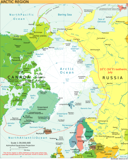
) year-round, and nearly all parts of the Arctic experience long periods with some form of ice on the surface. Average January temperatures range from about −40 C, and winter temperatures can drop below −50 C over large parts of the Arctic. Average July temperatures range from about −10 C, with some land areas occasionally exceeding 30 °C (86 °F) in summer.
The Arctic consists of ocean that is nearly surrounded by land. As such, the climate of much of the Arctic is moderated by the ocean water, which can never have a temperature below −2 C. In winter, this relatively warm water, even though covered by the polar ice pack, keeps the North Pole
North Pole
The North Pole, also known as the Geographic North Pole or Terrestrial North Pole, is, subject to the caveats explained below, defined as the point in the northern hemisphere where the Earth's axis of rotation meets its surface...
from being the coldest place in the Northern Hemisphere
Northern Hemisphere
The Northern Hemisphere is the half of a planet that is north of its equator—the word hemisphere literally means “half sphere”. It is also that half of the celestial sphere north of the celestial equator...
, and it is also part of the reason that Antarctica is so much colder than the Arctic. In summer, the presence of the near-by water keeps coastal areas from warming as much as they might otherwise, just as it does in temperate
Temperate
In geography, temperate or tepid latitudes of the globe lie between the tropics and the polar circles. The changes in these regions between summer and winter are generally relatively moderate, rather than extreme hot or cold...
regions with maritime climates.
Antarctica
The climateClimate
Climate encompasses the statistics of temperature, humidity, atmospheric pressure, wind, rainfall, atmospheric particle count and other meteorological elemental measurements in a given region over long periods...
of Antarctica is the coldest on the whole of Earth. Antarctica has the lowest temperature
Temperature
Temperature is a physical property of matter that quantitatively expresses the common notions of hot and cold. Objects of low temperature are cold, while various degrees of higher temperatures are referred to as warm or hot...
ever recorded: −89.2 C at Vostok Station. It is also extremely dry (technically a desert
Desert
A desert is a landscape or region that receives an extremely low amount of precipitation, less than enough to support growth of most plants. Most deserts have an average annual precipitation of less than...
), averaging 166 millimetres (6.5 in) of precipitation
Precipitation (meteorology)
In meteorology, precipitation In meteorology, precipitation In meteorology, precipitation (also known as one of the classes of hydrometeors, which are atmospheric water phenomena is any product of the condensation of atmospheric water vapor that falls under gravity. The main forms of precipitation...
per year. Even so, on most parts of the continent the snow rarely melts and is eventually compressed to become the glacial
Glacier
A glacier is a large persistent body of ice that forms where the accumulation of snow exceeds its ablation over many years, often centuries. At least 0.1 km² in area and 50 m thick, but often much larger, a glacier slowly deforms and flows due to stresses induced by its weight...
ice that makes up the ice sheet
Ice sheet
An ice sheet is a mass of glacier ice that covers surrounding terrain and is greater than 50,000 km² , thus also known as continental glacier...
. Weather front
Weather front
A weather front is a boundary separating two masses of air of different densities, and is the principal cause of meteorological phenomena. In surface weather analyses, fronts are depicted using various colored lines and symbols, depending on the type of front...
s rarely penetrate far into the continent.
Quantifying polar climate
There have been several attempts at quantifying what constitutes a polar climate.Climatologist Wladimir Köppen
Wladimir Köppen
Wladimir Peter Köppen was a Russian geographer, meteorologist, climatologist and botanist. After studies in St. Petersburg, he spent the bulk of his life and professional career in Germany and Austria...
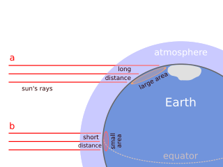
demonstrated a relationship between the Arctic and Antarctic tree lines and the 10 °C (50 °F) summer isotherm; i.e., places where the average temperature in the warmest calendar month of the year is below 10 °C (50 °F) cannot support forests. See Köppen climate classification
Köppen climate classification
The Köppen climate classification is one of the most widely used climate classification systems. It was first published by Crimea German climatologist Wladimir Köppen in 1884, with several later modifications by Köppen himself, notably in 1918 and 1936...
for more information.
Otto Nordenskiöld
Otto Nordenskiöld
Nils Otto Gustaf Nordenskjöld was a Finnish and Swedish geologist, geographer, and polar explorer.-Biography:...
theorized that winter conditions also play a role: His formula is W = 9 − 0.1 C, where W is the average temperature in the warmest month and C the average of the coldest month, both in degrees Celsius (this would mean, for example, that if a particular location had an average temperature of −20 C in its coldest month, the warmest month would need to average 11 °C (51.8 °F) or higher for trees to be able to survive there). Nordenskiöld's line tends to run to the north of Köppen's near the west coasts of the Northern Hemisphere continents, south of it in the interior sections, and at about the same latitude along the east coasts of both Asia and North America. In the Southern Hemisphere, all of Tierra del Fuego
Tierra del Fuego
Tierra del Fuego is an archipelago off the southernmost tip of the South American mainland, across the Strait of Magellan. The archipelago consists of a main island Isla Grande de Tierra del Fuego divided between Chile and Argentina with an area of , and a group of smaller islands including Cape...
lies outside the polar region in Nordenskiöld's system, but part of the island (including Ushuaia, Argentina) is reckoned as being within the Antarctic under Köppen's.
In 1947, Holdridge improved on these schemes, by defining biotemperature: the mean annual temperature, where all temperatures below 0 °C (32 °F) are treated as 0 °C (32 °F) (because it makes no difference to plant life, being dormant). If the mean biotemperature is between 1.5 and 3 °C (34.7 and 37.4 F), Holdridge quantifies the climate as subpolar
Subarctic climate
The subarctic climate is a climate characterized by long, usually very cold winters, and short, cool to mild summers. It is found on large landmasses, away from the moderating effects of an ocean, generally at latitudes from 50° to 70°N poleward of the humid continental climates...
(or alpine, if the low temperature is caused by altitude).