
Ice sheet
Encyclopedia
Glacier
A glacier is a large persistent body of ice that forms where the accumulation of snow exceeds its ablation over many years, often centuries. At least 0.1 km² in area and 50 m thick, but often much larger, a glacier slowly deforms and flows due to stresses induced by its weight...
ice
Ice
Ice is water frozen into the solid state. Usually ice is the phase known as ice Ih, which is the most abundant of the varying solid phases on the Earth's surface. It can appear transparent or opaque bluish-white color, depending on the presence of impurities or air inclusions...
that covers surrounding terrain and is greater than 50,000 km² (20,000 mile²), thus also known as continental glacier. The only current ice sheets are in Antarctica and Greenland
Greenland
Greenland is an autonomous country within the Kingdom of Denmark, located between the Arctic and Atlantic Oceans, east of the Canadian Arctic Archipelago. Though physiographically a part of the continent of North America, Greenland has been politically and culturally associated with Europe for...
; during the last glacial period at Last Glacial Maximum
Last Glacial Maximum
The Last Glacial Maximum refers to a period in the Earth's climate history when ice sheets were at their maximum extension, between 26,500 and 19,000–20,000 years ago, marking the peak of the last glacial period. During this time, vast ice sheets covered much of North America, northern Europe and...
(LGM) the Laurentide ice sheet
Laurentide ice sheet
The Laurentide Ice Sheet was a massive sheet of ice that covered hundreds of thousands of square miles, including most of Canada and a large portion of the northern United States, multiple times during Quaternary glacial epochs. It last covered most of northern North America between c. 95,000 and...
covered much of North America
North America
North America is a continent wholly within the Northern Hemisphere and almost wholly within the Western Hemisphere. It is also considered a northern subcontinent of the Americas...
, the Weichselian ice sheet covered northern Europe
Northern Europe
Northern Europe is the northern part or region of Europe. Northern Europe typically refers to the seven countries in the northern part of the European subcontinent which includes Denmark, Estonia, Latvia, Lithuania, Norway, Finland and Sweden...
and the Patagonian Ice Sheet
Patagonian Ice Sheet
350px|thumb|right|Map showing the extent of the Patagonian Ice Sheet in the [[Strait of Magellan]] area during the [[last glacial period]]. Selected modern settlements are shown with yellow dots...
covered southern South America
South America
South America is a continent situated in the Western Hemisphere, mostly in the Southern Hemisphere, with a relatively small portion in the Northern Hemisphere. The continent is also considered a subcontinent of the Americas. It is bordered on the west by the Pacific Ocean and on the north and east...
.
Ice sheets are bigger than ice shelves
Ice shelf
An ice shelf is a thick, floating platform of ice that forms where a glacier or ice sheet flows down to a coastline and onto the ocean surface. Ice shelves are only found in Antarctica, Greenland and Canada. The boundary between the floating ice shelf and the grounded ice that feeds it is called...
or alpine glacier
Glacier
A glacier is a large persistent body of ice that forms where the accumulation of snow exceeds its ablation over many years, often centuries. At least 0.1 km² in area and 50 m thick, but often much larger, a glacier slowly deforms and flows due to stresses induced by its weight...
s. Masses of ice covering less than 50,000 km2 are termed an ice cap
Ice cap
An ice cap is an ice mass that covers less than 50 000 km² of land area . Masses of ice covering more than 50 000 km² are termed an ice sheet....
. An ice cap will typically feed a series of glaciers around its periphery.
Although the surface is cold, the base of an ice sheet is generally warmer due to geothermal
Geothermal
Geothermal is related to energy and may refer to:* The geothermal gradient and associated heat flows from within the Earth- Renewable technology :...
heat. In places, melting occurs and the melt-water lubricates the ice sheet so that it flows more rapidly. This process produces fast-flowing channels in the ice sheet — these are ice stream
Ice stream
An ice stream is a region of an ice sheet that moves significantly faster than the surrounding ice. Ice streams are a type of glacier. They are significant features of the Antarctic where they account for 10% of the volume of the ice...
s.
The present-day polar ice sheets are relatively young in geological terms. The Antarctic Ice Sheet first formed as a small ice cap (maybe several) in the early Oligocene
Oligocene
The Oligocene is a geologic epoch of the Paleogene Period and extends from about 34 million to 23 million years before the present . As with other older geologic periods, the rock beds that define the period are well identified but the exact dates of the start and end of the period are slightly...
, but retreating and advancing many times until the Pliocene
Pliocene
The Pliocene Epoch is the period in the geologic timescale that extends from 5.332 million to 2.588 million years before present. It is the second and youngest epoch of the Neogene Period in the Cenozoic Era. The Pliocene follows the Miocene Epoch and is followed by the Pleistocene Epoch...
, when it came to occupy almost all of Antarctica. The Greenland ice sheet did not develop at all until the late Pliocene, but apparently developed very rapidly with the first continental glaciation. This had the unusual effect of allowing fossil
Fossil
Fossils are the preserved remains or traces of animals , plants, and other organisms from the remote past...
s of plant
Plant
Plants are living organisms belonging to the kingdom Plantae. Precise definitions of the kingdom vary, but as the term is used here, plants include familiar organisms such as trees, flowers, herbs, bushes, grasses, vines, ferns, mosses, and green algae. The group is also called green plants or...
s that once grew on present-day Greenland to be much better preserved than with the slowly forming Antarctic ice sheet.
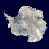
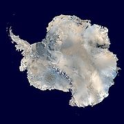
Antarctic ice sheet
The Antarctic ice sheetAntarctic ice sheet
The Antarctic ice sheet is one of the two polar ice caps of the Earth. It covers about 98% of the Antarctic continent and is the largest single mass of ice on Earth. It covers an area of almost 14 million square km and contains 30 million cubic km of ice...
is the largest single mass of ice on Earth
Earth
Earth is the third planet from the Sun, and the densest and fifth-largest of the eight planets in the Solar System. It is also the largest of the Solar System's four terrestrial planets...
. It covers an area of almost 14 million km2 and contains 30 million km3 of ice. Around 90% of the fresh water on the Earth's surface is held in the ice sheet, and, if melted, would cause sea levels to rise by 61.1 metres. The continent-wide average surface temperature trend of Antarctica is positive and significant at >0.05°C/decade since 1957.
The Antarctic ice sheet is divided by the Transantarctic Mountains
Transantarctic Mountains
The three largest mountain ranges on the Antarctic continent are the Transantarctic Mountains , the West Antarctica Ranges, and the East Antarctica Ranges. The Transantarctic Mountains compose a mountain range in Antarctica which extend, with some interruptions, across the continent from Cape Adare...
into two unequal sections called the East Antarctic ice sheet
East Antarctic Ice Sheet
The East Antarctic Ice Sheet is one of two large ice sheets in Antarctica, and the largest on the entire planet. The EAIS lies between 45° West and 168° East longitudinally....
(EAIS) and the smaller West Antarctic Ice Sheet
West Antarctic Ice Sheet
The West Antarctic Ice Sheet is the segment of the continental ice sheet that covers West Antarctica, the portion of Antarctica on the side of the Transantarctic Mountains which lies in the Western Hemisphere. The WAIS is classified as a marine-based ice sheet, meaning that its bed lies well...
(WAIS). The EAIS rests on a major land mass but the bed of the WAIS is, in places, more than 2,500 meters below sea level
Sea level
Mean sea level is a measure of the average height of the ocean's surface ; used as a standard in reckoning land elevation...
. It would be seabed
Seabed
The seabed is the bottom of the ocean.- Ocean structure :Most of the oceans have a common structure, created by common physical phenomena, mainly from tectonic movement, and sediment from various sources...
if the ice sheet were not there. The WAIS is classified as a marine-based ice sheet, meaning that its bed lies below sea level and its edges flow into floating ice shelves. The WAIS is bounded by the Ross Ice Shelf
Ross Ice Shelf
The Ross Ice Shelf is the largest ice shelf of Antarctica . It is several hundred metres thick. The nearly vertical ice front to the open sea is more than 600 km long, and between 15 and 50 metres high above the water surface...
, the Ronne Ice Shelf, and outlet glaciers that drain into the Amundsen Sea
Amundsen Sea
The Amundsen Sea is an arm of the Southern Ocean off Marie Byrd Land in western Antarctica. It is bounded by Cape Flying Fish, the northwestern tip of Thurston Island to the east and Cape Dart on Siple Island to the west. East of Cape Flying Fish starts the Bellingshausen Sea. West of Cape Dart is...
.
Greenland ice sheet

Greenland ice sheet
The Greenland ice sheet is a vast body of ice covering , roughly 80% of the surface of Greenland. It is the second largest ice body in the world, after the Antarctic Ice Sheet. The ice sheet is almost long in a north-south direction, and its greatest width is at a latitude of 77°N, near its...
occupies about 82% of the surface of Greenland
Greenland
Greenland is an autonomous country within the Kingdom of Denmark, located between the Arctic and Atlantic Oceans, east of the Canadian Arctic Archipelago. Though physiographically a part of the continent of North America, Greenland has been politically and culturally associated with Europe for...
, and if melted would cause sea levels to rise by 7.2 metres. Estimated changes in the mass of Greenland's ice sheet suggest it is melting at a rate of about 239 cubic kilometres (57.3 cubic miles) per year. These measurements came from NASA
NASA
The National Aeronautics and Space Administration is the agency of the United States government that is responsible for the nation's civilian space program and for aeronautics and aerospace research...
's Gravity Recovery and Climate Experiment
Gravity Recovery and Climate Experiment
The Gravity Recovery And Climate Experiment , a joint mission of NASA and the German Space Agency, has been making detailed measurements of Earth's gravity field since its launch in March 2002....
(GRACE) satellite, launched in 2002, as reported by BBC News in August 2006.
Ice sheet dynamics
Ice movement is dominated by the motion of glaciers, whose activity is determined by a number of processes. Their motion is the result of cyclic surges interspersed with longer periods of inactivity, on both hourly and time scales.Predicted effects of global warming
The Greenland, and probably the Antarctic, ice sheets have been losing mass recently, because losses by melting and outlet glaciers exceed accumulation of snowfall. According to the Intergovernmental Panel on Climate ChangeIntergovernmental Panel on Climate Change
The Intergovernmental Panel on Climate Change is a scientific intergovernmental body which provides comprehensive assessments of current scientific, technical and socio-economic information worldwide about the risk of climate change caused by human activity, its potential environmental and...
(IPCC), loss of Antarctic and Greenland ice sheet mass contributed, respectively, about 0.21 ± 0.35 and 0.21 ± 0.07 mm/year to sea level rise between 1993 and 2003.
The IPCC projects that ice mass loss from melting of the Greenland ice sheet will continue to outpace accumulation of snowfall. Accumulation of snowfall on the Antarctic ice sheet is projected to outpace losses from melting. However, loss of mass on the Antarctic sheet may continue, if there is sufficient loss to outlet glaciers. In the words of the IPCC, "Dynamical processes related to ice flow not included in current models
Ice sheet model
Ice sheet models use quantitative methods to simulate the evolution, dynamics and thermodynamics of ice sheets, such as the Greenland ice sheet, the Antarctic ice sheet or the large ice sheets on the northern hemisphere during the last glacial period...
but suggested by recent observations could increase the vulnerability of the ice sheets to warming, increasing future sea level rise. Understanding of these processes is limited and there is no consensus on their magnitude." More research work is therefore required in order to improve the reliability of predictions of ice-sheet response on global warming.
The effects on ice formations of an increasing in temperature will accelerate. When ice is melted away less light from the sun will be reflected back into space and more will be absorbed by the ocean water causing further rises in temperature. This positive feedback system will could become independent of climate change past a certain point which will cause huge losses of ice to the icecaps.
External links
- United Nations Environment Programme: Global Outlook for Ice and Snow
- http://www.nasa.gov/vision/earth/environment/ice_sheets.html