
Nordaustlandet
Encyclopedia
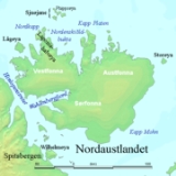
Nordaustlandet is the second-largest island
in the archipelago of Svalbard
, Norway
, with an area of 14443 square kilometres (5,576.5 sq mi). It lies north east of Spitsbergen
, separated by Hinlopenstretet. Much of Nordaustlandet lies under large ice cap
s, mainly Austfonna
and Vestfonna
, the remaining parts of the north being tundra
inhabited by reindeer
and walrus
es. The island is uninhabited and lies entirely within Nordaust-Svalbard Nature Reserve
.
.jpg) English
English
walrus hunters first sighted the south point of Nordaustlandet in 1617. This discovery was shown on the Muscovy Company's map (1625; but based on discoveries made in and prior to 1622), with the island labeled as Sir Thomas Smyth's Iland. It also shows the North Cape (Point Purchas). It is first named Oostlandt ("East Land") on a Dutch
map
of 1662, and the following year another Dutch map marked its coastline more distinctly, showing its west and north coasts, separating the latter from the Seven Islands (Sjuøyane
). A Dutch map of 1710 was the first to show the island accurately, naming it Het Noord Ooster Land ("The North-east Land").
Layered gabbro and dolerite of Silurian age occur at Kapp Laura in easternmost Nordaustlandet, on the island of Storøya, and in the eastern part of the island of Kvitøya. On Andréeneset, in the southern part of Kvitøya, gneisses and granites are the most common rock types. Four generations of rocks: gneiss, amfibolite, and grey and pink granite are present on Isispynten, a headland east of Austfonna. South of Wahlenbergfjorden there is a large area with sedimentary rocks – mostly limestone and dolomite – from the Carboniferous and Permian. The youngest rocks in Nordaustlandet are Jurassic–Cretaceous dolerite dikes, which intrude the basement rocks on the island of Lågøya and in the outlet of Brennevinsfjorden.
Unconsolidated deposits in Nordaustlandet consist of scree slopes, block fields and raised shore deposits. There are only small amounts of river deposits. The largest strandflats on Nordaustlandet can be found in the north-west, around Murchisonfjorden and on the island of Lågøya. Another large strandflat is Svartknausflya in the south, just west of the glacier of Bråsvellbreen. Here, there are raised shore deposits up to 120 m.a.s.l., where ancient whale bones have been found 70 m above today’s sea level. Svartknausflya is also the largest moraine area in Nordaustlandet; it measures about 70 km².
Glacial activity has shaped the landscape in Nordaustlandet through several ice ages. Gentle plateaus and rounded mountains are the most common sight. The tallest and steepest mountains, up to 600 m.a.s.l., can be found in the north. The eastern part of Nordaustlandet is covered in glaciers, and there are few areas without ice. Between Vibebukta and Kapp Laura, the steep front of the Austfonna ice cap dominates. The glacier has retracted a bit during recent decades, revealing new areas of dry land on the few headlands that can be found around here (such as Isispynten). Austfonna, including Vegafonna, stretch across an area of 8450 km². Austfonna covers approximately 58% of Nordaustlandet. Vestfonna is 2445 km². The largest areas with no ice are between Austfonna and Vestfonna and on the peninsulas in the north and north-west of Nordaustlandet.
The glacier Bråsvellbreen is a branch of Vestfonna. In 1937-1938 it had one of the largest surges ever recorded in Svalbard. The 30-km wide glacier front 20 km forwards and into the ocean.
_5.jpg)
Island
An island or isle is any piece of sub-continental land that is surrounded by water. Very small islands such as emergent land features on atolls can be called islets, cays or keys. An island in a river or lake may be called an eyot , or holm...
in the archipelago of Svalbard
Svalbard
Svalbard is an archipelago in the Arctic, constituting the northernmost part of Norway. It is located north of mainland Europe, midway between mainland Norway and the North Pole. The group of islands range from 74° to 81° north latitude , and from 10° to 35° east longitude. Spitsbergen is the...
, Norway
Norway
Norway , officially the Kingdom of Norway, is a Nordic unitary constitutional monarchy whose territory comprises the western portion of the Scandinavian Peninsula, Jan Mayen, and the Arctic archipelago of Svalbard and Bouvet Island. Norway has a total area of and a population of about 4.9 million...
, with an area of 14443 square kilometres (5,576.5 sq mi). It lies north east of Spitsbergen
Spitsbergen
Spitsbergen is the largest and only permanently populated island of the Svalbard archipelago in Norway. Constituting the western-most bulk of the archipelago, it borders the Arctic Ocean, the Norwegian Sea and the Greenland Sea...
, separated by Hinlopenstretet. Much of Nordaustlandet lies under large ice cap
Ice cap
An ice cap is an ice mass that covers less than 50 000 km² of land area . Masses of ice covering more than 50 000 km² are termed an ice sheet....
s, mainly Austfonna
Austfonna
Austfonna is an ice cap located on Nordaustlandet in the Svalbard archipelago in Norway. Covering an area of 8,105 km² it is the largest ice cap by area and with 1,900 km³ the second largest by volume in Europe, after the Vatnajökull in Iceland Austfonna is an ice cap located on Nordaustlandet in...
and Vestfonna
Vestfonna
Vestfonna is an ice cap located on the western part Nordaustlandet in the Svalbard archipelago in Norway. The glacier covers an area of about 2,500 km². It is the third largest ice cap in Svalbard and Norway by area, after Austfonna and Olav V Land....
, the remaining parts of the north being tundra
Tundra
In physical geography, tundra is a biome where the tree growth is hindered by low temperatures and short growing seasons. The term tundra comes through Russian тундра from the Kildin Sami word tūndâr "uplands," "treeless mountain tract." There are three types of tundra: Arctic tundra, alpine...
inhabited by reindeer
Reindeer
The reindeer , also known as the caribou in North America, is a deer from the Arctic and Subarctic, including both resident and migratory populations. While overall widespread and numerous, some of its subspecies are rare and one has already gone extinct.Reindeer vary considerably in color and size...
and walrus
Walrus
The walrus is a large flippered marine mammal with a discontinuous circumpolar distribution in the Arctic Ocean and sub-Arctic seas of the Northern Hemisphere. The walrus is the only living species in the Odobenidae family and Odobenus genus. It is subdivided into three subspecies: the Atlantic...
es. The island is uninhabited and lies entirely within Nordaust-Svalbard Nature Reserve
Nordaust-Svalbard Nature Reserve
Nordaust-Svalbard Nature Reserve is located in the north-eastern part of the Svalbard archipelago in Norway. The nature reserve covers all of Nordaustlandet, Kong Karls Land, Kvitøya, Sjuøyane, Storøya, Lågøya, Wilhelmøya, Wahlbergøya and a small section of the north-east corner of Spitsbergen...
.
History
England
England is a country that is part of the United Kingdom. It shares land borders with Scotland to the north and Wales to the west; the Irish Sea is to the north west, the Celtic Sea to the south west, with the North Sea to the east and the English Channel to the south separating it from continental...
walrus hunters first sighted the south point of Nordaustlandet in 1617. This discovery was shown on the Muscovy Company's map (1625; but based on discoveries made in and prior to 1622), with the island labeled as Sir Thomas Smyth's Iland. It also shows the North Cape (Point Purchas). It is first named Oostlandt ("East Land") on a Dutch
Netherlands
The Netherlands is a constituent country of the Kingdom of the Netherlands, located mainly in North-West Europe and with several islands in the Caribbean. Mainland Netherlands borders the North Sea to the north and west, Belgium to the south, and Germany to the east, and shares maritime borders...
map
Map
A map is a visual representation of an area—a symbolic depiction highlighting relationships between elements of that space such as objects, regions, and themes....
of 1662, and the following year another Dutch map marked its coastline more distinctly, showing its west and north coasts, separating the latter from the Seven Islands (Sjuøyane
Sjuøyane
Sjuøyane is the northernmost part of the Svalbard archipelago, just north of Nordaustlandet. As the name implies, this is a group of seven islands , although three are mere islets. The principal islands are Phippsøya, Parryøya, Martensøya, Nelsonøya and Waldenøya, the islets are Tavleøya, Vesle...
). A Dutch map of 1710 was the first to show the island accurately, naming it Het Noord Ooster Land ("The North-east Land").
Geology and landscape
The rock types in Nordaustlandet stem from many different geological eras. The northern part consists of old crystalline basement, with rocks such as marble, quartzite, mica schist, gneiss and granite. East of Lady Franklinfjorden, on the peninsula Botniahalvøya and east of Duvefjorden there are volcanic rocks. In the east and south of Rijpfjorden the bedrock is made up of distinctive red-coloured granite... The Rijpfjord granite is medium grained, and contains two micas (muscovite and biotite) in addition to quartz, plagioclase and pink K-feldspar. It was emplaced in late Silurian times.Layered gabbro and dolerite of Silurian age occur at Kapp Laura in easternmost Nordaustlandet, on the island of Storøya, and in the eastern part of the island of Kvitøya. On Andréeneset, in the southern part of Kvitøya, gneisses and granites are the most common rock types. Four generations of rocks: gneiss, amfibolite, and grey and pink granite are present on Isispynten, a headland east of Austfonna. South of Wahlenbergfjorden there is a large area with sedimentary rocks – mostly limestone and dolomite – from the Carboniferous and Permian. The youngest rocks in Nordaustlandet are Jurassic–Cretaceous dolerite dikes, which intrude the basement rocks on the island of Lågøya and in the outlet of Brennevinsfjorden.
Unconsolidated deposits in Nordaustlandet consist of scree slopes, block fields and raised shore deposits. There are only small amounts of river deposits. The largest strandflats on Nordaustlandet can be found in the north-west, around Murchisonfjorden and on the island of Lågøya. Another large strandflat is Svartknausflya in the south, just west of the glacier of Bråsvellbreen. Here, there are raised shore deposits up to 120 m.a.s.l., where ancient whale bones have been found 70 m above today’s sea level. Svartknausflya is also the largest moraine area in Nordaustlandet; it measures about 70 km².
Glacial activity has shaped the landscape in Nordaustlandet through several ice ages. Gentle plateaus and rounded mountains are the most common sight. The tallest and steepest mountains, up to 600 m.a.s.l., can be found in the north. The eastern part of Nordaustlandet is covered in glaciers, and there are few areas without ice. Between Vibebukta and Kapp Laura, the steep front of the Austfonna ice cap dominates. The glacier has retracted a bit during recent decades, revealing new areas of dry land on the few headlands that can be found around here (such as Isispynten). Austfonna, including Vegafonna, stretch across an area of 8450 km². Austfonna covers approximately 58% of Nordaustlandet. Vestfonna is 2445 km². The largest areas with no ice are between Austfonna and Vestfonna and on the peninsulas in the north and north-west of Nordaustlandet.
The glacier Bråsvellbreen is a branch of Vestfonna. In 1937-1938 it had one of the largest surges ever recorded in Svalbard. The 30-km wide glacier front 20 km forwards and into the ocean.
See also
- List of islands of Norway
External links
- Western Nordauslandet on Svalbard Images. (URL accessed 24 July 2006)
- Eastern Nordauslandet on Svalbard Images. (URL accessed 24 July 2006)
- Map of Nordaustlandet
- Geology and landscape