
Pangaea
Overview
Ancient Greek
Ancient Greek is the stage of the Greek language in the periods spanning the times c. 9th–6th centuries BC, , c. 5th–4th centuries BC , and the c. 3rd century BC – 6th century AD of ancient Greece and the ancient world; being predated in the 2nd millennium BC by Mycenaean Greek...
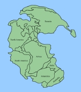
πᾶν pan "entire", and Γαῖα Gaia "Earth", Latinized as Gæa) is hypothesized as a supercontinent
Supercontinent
In geology, a supercontinent is a landmass comprising more than one continental core, or craton. The assembly of cratons and accreted terranes that form Eurasia qualifies as a supercontinent today.-History:...
that existed during the Paleozoic
Paleozoic
The Paleozoic era is the earliest of three geologic eras of the Phanerozoic eon, spanning from roughly...
and Mesozoic
Mesozoic
The Mesozoic era is an interval of geological time from about 250 million years ago to about 65 million years ago. It is often referred to as the age of reptiles because reptiles, namely dinosaurs, were the dominant terrestrial and marine vertebrates of the time...
eras about 250 million years ago, before the component continent
Continent
A continent is one of several very large landmasses on Earth. They are generally identified by convention rather than any strict criteria, with seven regions commonly regarded as continents—they are : Asia, Africa, North America, South America, Antarctica, Europe, and Australia.Plate tectonics is...
s were separated into their current configuration.
The name was coined during a 1927 symposium discussing Alfred Wegener
Alfred Wegener
Alfred Lothar Wegener was a German scientist, geophysicist, and meteorologist.He is most notable for his theory of continental drift , proposed in 1912, which hypothesized that the continents were slowly drifting around the Earth...
's theory of continental drift
Continental drift
Continental drift is the movement of the Earth's continents relative to each other. The hypothesis that continents 'drift' was first put forward by Abraham Ortelius in 1596 and was fully developed by Alfred Wegener in 1912...
. In his book The Origin of Continents and Oceans (Die Entstehung der Kontinente und Ozeane) first published in 1915, he postulated that all the continents had at one time formed a single supercontinent
Supercontinent
In geology, a supercontinent is a landmass comprising more than one continental core, or craton. The assembly of cratons and accreted terranes that form Eurasia qualifies as a supercontinent today.-History:...
which he called the "Urkontinent", before later breaking up and drifting to their present locations.
The single enormous ocean
Superocean
A superocean is an ocean which surrounds a supercontinent. It is less commonly defined as any ocean larger than the current Pacific Ocean. Named global superoceans include Mirovia, which surrounded the supercontinent Rodinia, and Panthalassa, which surrounded the supercontinent Pangaea...
which surrounded Pangaea was accordingly named Panthalassa
Panthalassa
Panthalassa , also known as the Panthalassic Ocean, was the vast global ocean that surrounded the supercontinent Pangaea, during the late Paleozoic and the early Mesozoic years. It included the Pacific Ocean to the west and north and the Tethys Ocean to the southeast...
.
The forming of supercontinents and their breaking up appears to be cyclical
Supercontinent cycle
The supercontinent cycle describes the quasi-periodic aggregation and dispersal of Earth's continental crust. There are varying opinions as to whether the amount of continental crust is increasing, decreasing, or staying about the same, but it is agreed that the Earth's crust is constantly being...
through Earth's 4.6 billion year history.
Unanswered Questions