
Permafrost
Encyclopedia
In geology
, permafrost, cryotic soil or permafrost soil is soil at or below the freezing point of water (0 °C or 32 °F) for two or more years. Ice is not always present, as may be in the case of nonporous bedrock, but it frequently occurs and it may be in amounts exceeding the potential hydraulic saturation of the ground material. Most permafrost is located in high latitude
s (i.e. land close to the North and South poles), but alpine permafrost may exist at high altitude
s in much lower latitudes. Permafrost accounts for 0.022% of total water and exists in 24% of exposed land in the Northern Hemisphere.
 The extent of permafrost can vary as the climate changes. Today, a considerable area of the Arctic is covered by permafrost (including discontinuous permafrost). Overlying permafrost is a thin active layer
that seasonally thaws during the summer. Plant
life can be supported only within the active layer since growth can occur only in soil that is fully thawed for some part of the year. Thickness of the active layer varies by year and location, but is typically 0.6–4 m (2–13.1 ft) thick. In areas of continuous permafrost and harsh winters the depth of the permafrost can be as much as 1493 m (4,898.3 ft) in the northern Lena
and Yana River
basins in Siberia
. Permafrost can also store carbon, both as peat
and as methane
. The most recent work investigating the permafrost carbon pool size estimates that 1400-1700 Gt of carbon is stored in permafrost soils worldwide. . This large carbon pool represents more carbon than currently exists in all living things and twice as much carbon as exists in the atmosphere.
 Permafrost will typically form in any climate
where the mean annual air temperature is less than the freezing point of water
. Exceptions are found in moist-wintered forest climates, such as in Northern Scandinavia and the North-Eastern part of European Russia west of the Urals
, where snow acts as an insulating blanket. The bottoms of many glaciers can also be free of permafrost.
Typically, the below-ground temperature will be less variable from season to season than the air temperature, with temperatures tending to increase with depth. Thus, if the mean annual air temperature is only slightly below 0 °C (32 °F), permafrost will form only in spots that are sheltered — usually with a northerly aspect
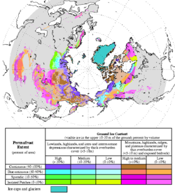
. This creates what is known as discontinuous permafrost. Usually, permafrost will remain discontinuous in a climate where the mean annual soil surface temperature is between -5 C. In the moist-wintered areas mentioned before, there may not be even discontinuous permafrost down to -2 °C. Discontinuous permafrost is often further divided into extensive discontinuous permafrost, where permafrost covers between 50 and 90 percent of the landscape and is usually found in areas with mean annual temperatures between -2 C, and sporadic permafrost, where permafrost cover is less than 50 percent of the landscape and typically occurs at mean annual temperatures between 0 and -2 °C (32 and 28.4 F).
In soil science, the sporadic permafrost zone is abbreviated SPZ and the extensive discontinuous permafrost zone DPZ.
There are exceptions in un-glaciated Siberia
and Alaska
where the present depth of permafrost is a relic of climatic conditions during glacial ages where winters were up to 11 °C (20 °F) colder than those of today. At mean annual soil surface temperatures below −5 °C (23 °F) the influence of aspect can never be sufficient to thaw permafrost and a zone of continuous permafrost (abbreviated to CPZ) forms. There are also "fossil" cold anomalies in the Geothermal gradient
in areas where deep permafrost developed during the Pleistocene that still persists down to several hundred metres. The Suwałki cold anomaly in Poland led to the recognition that similar thermal disturbances related to Pleistocene-Holocene climatic changes are recorded in boreholes throughout Poland. http://www.pgi.gov.pl/pgi_en/index.php?option=news&task=viewarticle&sid=107
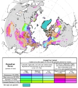
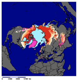
A line of continuous permafrost in the Northern Hemisphere
(Frozen Ground 28, 2004, p5) is formed from the most northerly points at which permafrost sometimes thaws or is interrupted by regions without permafrost. North of this line all land is covered by permafrost or glacial ice. The "line" of continuous permafrost lies further north at some longitude
s than others and can gradually move northward or southward due to regional climatic changes. In the southern hemisphere
, most of the equivalent line would fall within the Southern Ocean
if there were land there. Most of the Antarctic continent is overlain by glaciers.
In the Andes
at Atacama Desert
permafrost extends down to an altitude of 4,400 metres and is continuous above 5,600 metres.
In Yukon
, the zone of continuous permafrost might have moved 100 kilometres poleward since 1899, but accurate records only go back 30 years. It is thought that permafrost thawing could exacerbate global warming by releasing methane
and other hydrocarbon
s, which are powerful greenhouse gases. It also could encourage erosion
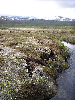
because permafrost lends stability to barren Arctic slopes.
At the Last Glacial Maximum
, continuous permafrost covered a much greater area than it does today, covering all of ice-free Europe
south to about Szeged
(southeastern Hungary) and the Sea of Azov
(then dry land) and China
south to Beijing
. In North America
, only an extremely narrow belt of permafrost existed south of the ice sheet
at about the latitude of New Jersey
through southern Iowa
and northern Missouri
. In the southern hemisphere, there is some evidence for former permafrost from this period in central Otago
and Argentine
Patagonia
, but was probably discontinuous, and is related to the tundra.
in extensive permafrost areas, since this species can tolerate rooting pattern constrained to the near surface.
is a term used to describe the distinct, and often symmetrical geometric shapes formed by ground material in periglacial regions.
It has been calculated that the time required to form the deep permafrost underlying Prudhoe Bay, Alaska
is 500,740 years. This time extends over several glacial and interglacial cycles of the Pleistocene
and suggests that the present climate of Prudhoe Bay is probably considerably warmer than it has been on average over that period. Such warming over the past 15,000 years is widely accepted.
The table to the right shows that the first hundred metres of permafrost forms relatively quickly but that deeper levels take progressively longer.
 Building on permafrost is difficult due to the heat of the building (or pipeline
) thawing the permafrost and sinking. This problem has three common solutions: using foundations
on wood piles
; building on a thick gravel
pad (usually 1–2 metres/3.3-6.6 feet thick); or using anhydrous ammonia heat pipe
s. The Trans-Alaska Pipeline System
uses insulated heat pipes to prevent the pipeline from sinking. Qingzang railway
in Tibet
was built using a variety of methods to keep the ground cool.
At the Permafrost Research Institute in Yakutsk
, it has been found that the sinking of large buildings into the ground can be prevented by using stilts extending down to about fifteen metres or more. At this depth the temperature does not change with the seasons, remaining at about -5 °C (23F).
Geology
Geology is the science comprising the study of solid Earth, the rocks of which it is composed, and the processes by which it evolves. Geology gives insight into the history of the Earth, as it provides the primary evidence for plate tectonics, the evolutionary history of life, and past climates...
, permafrost, cryotic soil or permafrost soil is soil at or below the freezing point of water (0 °C or 32 °F) for two or more years. Ice is not always present, as may be in the case of nonporous bedrock, but it frequently occurs and it may be in amounts exceeding the potential hydraulic saturation of the ground material. Most permafrost is located in high latitude
Latitude
In geography, the latitude of a location on the Earth is the angular distance of that location south or north of the Equator. The latitude is an angle, and is usually measured in degrees . The equator has a latitude of 0°, the North pole has a latitude of 90° north , and the South pole has a...
s (i.e. land close to the North and South poles), but alpine permafrost may exist at high altitude
Altitude
Altitude or height is defined based on the context in which it is used . As a general definition, altitude is a distance measurement, usually in the vertical or "up" direction, between a reference datum and a point or object. The reference datum also often varies according to the context...
s in much lower latitudes. Permafrost accounts for 0.022% of total water and exists in 24% of exposed land in the Northern Hemisphere.
Active layer
In environments containing permafrost, the active layer is the top layer of soil that thaws during the summer and freezes again during the autumn. In all climates, whether they contain permafrost or not, the temperature in the lower levels of the soil will remain more stable than that at the...
that seasonally thaws during the summer. Plant
Plant
Plants are living organisms belonging to the kingdom Plantae. Precise definitions of the kingdom vary, but as the term is used here, plants include familiar organisms such as trees, flowers, herbs, bushes, grasses, vines, ferns, mosses, and green algae. The group is also called green plants or...
life can be supported only within the active layer since growth can occur only in soil that is fully thawed for some part of the year. Thickness of the active layer varies by year and location, but is typically 0.6–4 m (2–13.1 ft) thick. In areas of continuous permafrost and harsh winters the depth of the permafrost can be as much as 1493 m (4,898.3 ft) in the northern Lena
Lena River
The Lena is the easternmost of the three great Siberian rivers that flow into the Arctic Ocean . It is the 11th longest river in the world and has the 9th largest watershed...
and Yana River
Yana River
The Yana River , is a river in Sakha in Russia, located between the Lena to the west and the Indigirka to the east.It is 872 km in length. The area of its basin is 238,000 km², whilst its annual discharge totals approximately . Most of this discharge occurs in May and June as the ice on the...
basins in Siberia
Siberia
Siberia is an extensive region constituting almost all of Northern Asia. Comprising the central and eastern portion of the Russian Federation, it was part of the Soviet Union from its beginning, as its predecessor states, the Tsardom of Russia and the Russian Empire, conquered it during the 16th...
. Permafrost can also store carbon, both as peat
Peat
Peat is an accumulation of partially decayed vegetation matter or histosol. Peat forms in wetland bogs, moors, muskegs, pocosins, mires, and peat swamp forests. Peat is harvested as an important source of fuel in certain parts of the world...
and as methane
Methane
Methane is a chemical compound with the chemical formula . It is the simplest alkane, the principal component of natural gas, and probably the most abundant organic compound on earth. The relative abundance of methane makes it an attractive fuel...
. The most recent work investigating the permafrost carbon pool size estimates that 1400-1700 Gt of carbon is stored in permafrost soils worldwide. . This large carbon pool represents more carbon than currently exists in all living things and twice as much carbon as exists in the atmosphere.
Continuous and discontinuous permafrost
Climate
Climate encompasses the statistics of temperature, humidity, atmospheric pressure, wind, rainfall, atmospheric particle count and other meteorological elemental measurements in a given region over long periods...
where the mean annual air temperature is less than the freezing point of water
Water
Water is a chemical substance with the chemical formula H2O. A water molecule contains one oxygen and two hydrogen atoms connected by covalent bonds. Water is a liquid at ambient conditions, but it often co-exists on Earth with its solid state, ice, and gaseous state . Water also exists in a...
. Exceptions are found in moist-wintered forest climates, such as in Northern Scandinavia and the North-Eastern part of European Russia west of the Urals
Ural Mountains
The Ural Mountains , or simply the Urals, are a mountain range that runs approximately from north to south through western Russia, from the coast of the Arctic Ocean to the Ural River and northwestern Kazakhstan. Their eastern side is usually considered the natural boundary between Europe and Asia...
, where snow acts as an insulating blanket. The bottoms of many glaciers can also be free of permafrost.
Typically, the below-ground temperature will be less variable from season to season than the air temperature, with temperatures tending to increase with depth. Thus, if the mean annual air temperature is only slightly below 0 °C (32 °F), permafrost will form only in spots that are sheltered — usually with a northerly aspect
Aspect (geography)
In physical geography, aspect generally refers to the horizontal direction to which a mountain slope faces. For example, a slope on the eastern edge of the Rockies toward the Great Plains is described as having an easterly aspect...
. This creates what is known as discontinuous permafrost. Usually, permafrost will remain discontinuous in a climate where the mean annual soil surface temperature is between -5 C. In the moist-wintered areas mentioned before, there may not be even discontinuous permafrost down to -2 °C. Discontinuous permafrost is often further divided into extensive discontinuous permafrost, where permafrost covers between 50 and 90 percent of the landscape and is usually found in areas with mean annual temperatures between -2 C, and sporadic permafrost, where permafrost cover is less than 50 percent of the landscape and typically occurs at mean annual temperatures between 0 and -2 °C (32 and 28.4 F).
In soil science, the sporadic permafrost zone is abbreviated SPZ and the extensive discontinuous permafrost zone DPZ.
There are exceptions in un-glaciated Siberia
Siberia
Siberia is an extensive region constituting almost all of Northern Asia. Comprising the central and eastern portion of the Russian Federation, it was part of the Soviet Union from its beginning, as its predecessor states, the Tsardom of Russia and the Russian Empire, conquered it during the 16th...
and Alaska
Alaska
Alaska is the largest state in the United States by area. It is situated in the northwest extremity of the North American continent, with Canada to the east, the Arctic Ocean to the north, and the Pacific Ocean to the west and south, with Russia further west across the Bering Strait...
where the present depth of permafrost is a relic of climatic conditions during glacial ages where winters were up to 11 °C (20 °F) colder than those of today. At mean annual soil surface temperatures below −5 °C (23 °F) the influence of aspect can never be sufficient to thaw permafrost and a zone of continuous permafrost (abbreviated to CPZ) forms. There are also "fossil" cold anomalies in the Geothermal gradient
Geothermal gradient
Geothermal gradient is the rate of increasing temperature with respect to increasing depth in the Earth's interior. Away from tectonic plate boundaries, it is 25–30°C per km of depth in most of the world. Strictly speaking, geo-thermal necessarily refers to the Earth but the concept may be applied...
in areas where deep permafrost developed during the Pleistocene that still persists down to several hundred metres. The Suwałki cold anomaly in Poland led to the recognition that similar thermal disturbances related to Pleistocene-Holocene climatic changes are recorded in boreholes throughout Poland. http://www.pgi.gov.pl/pgi_en/index.php?option=news&task=viewarticle&sid=107
A line of continuous permafrost in the Northern Hemisphere
Northern Hemisphere
The Northern Hemisphere is the half of a planet that is north of its equator—the word hemisphere literally means “half sphere”. It is also that half of the celestial sphere north of the celestial equator...
(Frozen Ground 28, 2004, p5) is formed from the most northerly points at which permafrost sometimes thaws or is interrupted by regions without permafrost. North of this line all land is covered by permafrost or glacial ice. The "line" of continuous permafrost lies further north at some longitude
Longitude
Longitude is a geographic coordinate that specifies the east-west position of a point on the Earth's surface. It is an angular measurement, usually expressed in degrees, minutes and seconds, and denoted by the Greek letter lambda ....
s than others and can gradually move northward or southward due to regional climatic changes. In the southern hemisphere
Southern Hemisphere
The Southern Hemisphere is the part of Earth that lies south of the equator. The word hemisphere literally means 'half ball' or "half sphere"...
, most of the equivalent line would fall within the Southern Ocean
Southern Ocean
The Southern Ocean comprises the southernmost waters of the World Ocean, generally taken to be south of 60°S latitude and encircling Antarctica. It is usually regarded as the fourth-largest of the five principal oceanic divisions...
if there were land there. Most of the Antarctic continent is overlain by glaciers.
In the Andes
Andes
The Andes is the world's longest continental mountain range. It is a continual range of highlands along the western coast of South America. This range is about long, about to wide , and of an average height of about .Along its length, the Andes is split into several ranges, which are separated...
at Atacama Desert
Atacama Desert
The Atacama Desert is a plateau in South America, covering a strip of land on the Pacific coast, west of the Andes mountains. It is, according to NASA, National Geographic and many other publications, the driest desert in the world...
permafrost extends down to an altitude of 4,400 metres and is continuous above 5,600 metres.
Changes in permafrost extent
In Yukon
Yukon
Yukon is the westernmost and smallest of Canada's three federal territories. It was named after the Yukon River. The word Yukon means "Great River" in Gwich’in....
, the zone of continuous permafrost might have moved 100 kilometres poleward since 1899, but accurate records only go back 30 years. It is thought that permafrost thawing could exacerbate global warming by releasing methane
Methane
Methane is a chemical compound with the chemical formula . It is the simplest alkane, the principal component of natural gas, and probably the most abundant organic compound on earth. The relative abundance of methane makes it an attractive fuel...
and other hydrocarbon
Hydrocarbon
In organic chemistry, a hydrocarbon is an organic compound consisting entirely of hydrogen and carbon. Hydrocarbons from which one hydrogen atom has been removed are functional groups, called hydrocarbyls....
s, which are powerful greenhouse gases. It also could encourage erosion
Erosion
Erosion is when materials are removed from the surface and changed into something else. It only works by hydraulic actions and transport of solids in the natural environment, and leads to the deposition of these materials elsewhere...
because permafrost lends stability to barren Arctic slopes.
At the Last Glacial Maximum
Last Glacial Maximum
The Last Glacial Maximum refers to a period in the Earth's climate history when ice sheets were at their maximum extension, between 26,500 and 19,000–20,000 years ago, marking the peak of the last glacial period. During this time, vast ice sheets covered much of North America, northern Europe and...
, continuous permafrost covered a much greater area than it does today, covering all of ice-free Europe
Europe
Europe is, by convention, one of the world's seven continents. Comprising the westernmost peninsula of Eurasia, Europe is generally 'divided' from Asia to its east by the watershed divides of the Ural and Caucasus Mountains, the Ural River, the Caspian and Black Seas, and the waterways connecting...
south to about Szeged
Szeged
' is the third largest city of Hungary, the largest city and regional centre of the Southern Great Plain and the county town of Csongrád county. The University of Szeged is one of the most distinguished universities in Hungary....
(southeastern Hungary) and the Sea of Azov
Sea of Azov
The Sea of Azov , known in Classical Antiquity as Lake Maeotis, is a sea on the south of Eastern Europe. It is linked by the narrow Strait of Kerch to the Black Sea to the south and is bounded on the north by Ukraine mainland, on the east by Russia, and on the west by the Ukraine's Crimean...
(then dry land) and China
China
Chinese civilization may refer to:* China for more general discussion of the country.* Chinese culture* Greater China, the transnational community of ethnic Chinese.* History of China* Sinosphere, the area historically affected by Chinese culture...
south to Beijing
Beijing
Beijing , also known as Peking , is the capital of the People's Republic of China and one of the most populous cities in the world, with a population of 19,612,368 as of 2010. The city is the country's political, cultural, and educational center, and home to the headquarters for most of China's...
. In North America
North America
North America is a continent wholly within the Northern Hemisphere and almost wholly within the Western Hemisphere. It is also considered a northern subcontinent of the Americas...
, only an extremely narrow belt of permafrost existed south of the ice sheet
Ice sheet
An ice sheet is a mass of glacier ice that covers surrounding terrain and is greater than 50,000 km² , thus also known as continental glacier...
at about the latitude of New Jersey
New Jersey
New Jersey is a state in the Northeastern and Middle Atlantic regions of the United States. , its population was 8,791,894. It is bordered on the north and east by the state of New York, on the southeast and south by the Atlantic Ocean, on the west by Pennsylvania and on the southwest by Delaware...
through southern Iowa
Iowa
Iowa is a state located in the Midwestern United States, an area often referred to as the "American Heartland". It derives its name from the Ioway people, one of the many American Indian tribes that occupied the state at the time of European exploration. Iowa was a part of the French colony of New...
and northern Missouri
Missouri
Missouri is a US state located in the Midwestern United States, bordered by Iowa, Illinois, Kentucky, Tennessee, Arkansas, Oklahoma, Kansas and Nebraska. With a 2010 population of 5,988,927, Missouri is the 18th most populous state in the nation and the fifth most populous in the Midwest. It...
. In the southern hemisphere, there is some evidence for former permafrost from this period in central Otago
Otago
Otago is a region of New Zealand in the south of the South Island. The region covers an area of approximately making it the country's second largest region. The population of Otago is...
and Argentine
Argentina
Argentina , officially the Argentine Republic , is the second largest country in South America by land area, after Brazil. It is constituted as a federation of 23 provinces and an autonomous city, Buenos Aires...
Patagonia
Patagonia
Patagonia is a region located in Argentina and Chile, integrating the southernmost section of the Andes mountains to the southwest towards the Pacific ocean and from the east of the cordillera to the valleys it follows south through Colorado River towards Carmen de Patagones in the Atlantic Ocean...
, but was probably discontinuous, and is related to the tundra.
Ecological consequences
Formation of permafrost has significant consequences for ecological systems, primarily due to constraints imposed upon rooting zones, but also due to limitations on den and burrow geometries for fauna requiring subsurface homes. Of course, there are secondary effects from species dependent on plants and animals whose habitat is constrained by the permafrost. One of the most widespread examples is the dominance of Black SpruceBlack Spruce
Picea mariana is a species of spruce native to northern North America, from Newfoundland west to Alaska, and south to northern New York, Minnesota and central British Columbia...
in extensive permafrost areas, since this species can tolerate rooting pattern constrained to the near surface.
Patterned ground
Patterned groundPatterned ground
Patterned ground is a term used to describe the distinct, and often symmetrical geometric shapes formed by ground material in periglacial regions...
is a term used to describe the distinct, and often symmetrical geometric shapes formed by ground material in periglacial regions.
Time to form deep permafrost
| Time (yr) | Permafrost depth |
|---|---|
| 1 | 4.44 m (14.6 ft) |
| 350 | 79.9 m (262.1 ft) |
| 3,500 | 219.3 m (719.5 ft) |
| 35,000 | 461.4 m (1,513.8 ft) |
| 100,000 | 567.8 m (1,862.9 ft) |
| 225,000 | 626.5 m (2,055.4 ft) |
| 775,000 | 687.7 m (2,256.2 ft) |
It has been calculated that the time required to form the deep permafrost underlying Prudhoe Bay, Alaska
Prudhoe Bay, Alaska
Prudhoe Bay or Sagavanirktok is a census-designated place located in North Slope Borough in the U.S. state of Alaska. As of the 2010 census, the population of the CDP was 2,174 people; however, at any given time several thousand transient workers support the Prudhoe Bay oil field...
is 500,740 years. This time extends over several glacial and interglacial cycles of the Pleistocene
Pleistocene
The Pleistocene is the epoch from 2,588,000 to 11,700 years BP that spans the world's recent period of repeated glaciations. The name pleistocene is derived from the Greek and ....
and suggests that the present climate of Prudhoe Bay is probably considerably warmer than it has been on average over that period. Such warming over the past 15,000 years is widely accepted.
The table to the right shows that the first hundred metres of permafrost forms relatively quickly but that deeper levels take progressively longer.
Construction on permafrost
Pipeline transport
Pipeline transport is the transportation of goods through a pipe. Most commonly, liquids and gases are sent, but pneumatic tubes that transport solid capsules using compressed air are also used....
) thawing the permafrost and sinking. This problem has three common solutions: using foundations
Foundation (architecture)
A foundation is the lowest and supporting layer of a structure. Foundations are generally divided into two categories: shallow foundations and deep foundations.-Shallow foundations:...
on wood piles
Deep foundation
A deep foundation is a type of foundation distinguished from shallow foundations by the depth they are embedded into the ground. There are many reasons a geotechnical engineer would recommend a deep foundation over a shallow foundation, but some of the common reasons are very large design loads, a...
; building on a thick gravel
Gravel
Gravel is composed of unconsolidated rock fragments that have a general particle size range and include size classes from granule- to boulder-sized fragments. Gravel can be sub-categorized into granule and cobble...
pad (usually 1–2 metres/3.3-6.6 feet thick); or using anhydrous ammonia heat pipe
Heat pipe
A heat pipe or heat pin is a heat-transfer device that combines the principles of both thermal conductivity and phase transition to efficiently manage the transfer of heat between two solid interfaces....
s. The Trans-Alaska Pipeline System
Trans-Alaska Pipeline System
The Trans Alaska Pipeline System , includes the Trans Alaska Pipeline, 11 pump stations, several hundred miles of feeder pipelines, and the Valdez Marine Terminal. TAPS is one of the world's largest pipeline systems...
uses insulated heat pipes to prevent the pipeline from sinking. Qingzang railway
Qingzang railway
The Qinghai–Xizang railway, Qingzang railway, or Qinghai–Tibet railway , is a high-elevation railway that connects Xining, Qinghai Province, to Lhasa, Tibet Autonomous Region, in People's Republic of China....
in Tibet
Tibet
Tibet is a plateau region in Asia, north-east of the Himalayas. It is the traditional homeland of the Tibetan people as well as some other ethnic groups such as Monpas, Qiang, and Lhobas, and is now also inhabited by considerable numbers of Han and Hui people...
was built using a variety of methods to keep the ground cool.
At the Permafrost Research Institute in Yakutsk
Yakutsk
With a subarctic climate , Yakutsk is the coldest city, though not the coldest inhabited place, on Earth. Average monthly temperatures range from in July to in January. The coldest temperatures ever recorded on the planet outside Antarctica occurred in the basin of the Yana River to the northeast...
, it has been found that the sinking of large buildings into the ground can be prevented by using stilts extending down to about fifteen metres or more. At this depth the temperature does not change with the seasons, remaining at about -5 °C (23F).
See also
- Arctic methane releaseArctic methane releaseArctic methane release is the release of methane from seas and soils in permafrost regions of the Arctic, as part of a more general release of carbon from these soils and seas. Whilst a long-term natural process, it may be exacerbated by global warming. This results in a weak positive feedback...
- Drunken treesDrunken treesDrunken trees, tilted trees, or a drunken forest, is a stand of trees displaced from their normal vertical alignment.This most commonly occurs in northern subarctic taiga forests of Black Spruce under which discontinuous permafrost or ice wedges have melted, causing trees to tilt at various...
- International Permafrost AssociationInternational Permafrost AssociationThe International Permafrost Association , founded in 1983, has as its objectives to foster the dissemination of knowledge concerning permafrost and to promote cooperation among persons and national or international organisations engaged in scientific investigation and engineering work related to...
- Permafrost Young Researchers NetworkPermafrost Young Researchers NetworkThe Permafrost Young Researcher’s Network is a network formed in 2005 to formally facilitate and strengthen contacts among young scientists in the permafrost community. It arose from the need for an integrated single source of information for specific resources vital to young scientists...
- PalsaPalsathumb|right|300px|A group of well developed palsas as seen from abovePalsas are low, often oval, frost heaves occurring in polar and subpolar climates, which contain permanently frozen ice lenses...
- PingoPingoA pingo, also called a hydrolaccolith, is a mound of earth-covered ice found in the Arctic and subarctic that can reach up to in height and up to in diameter. The term originated as the Inuvialuktun word for a small hill. A pingo is a periglacial landform, which is defined as a nonglacial...
- Alas
- YedomaYedomaYedoma is an organic-rich Pleistocene-age loess permafrost with ice content of 50–90% by volume. The amount of carbon trapped in this type of permafrost is much more prevalent than originally thought and may be about 500 Gt, that is almost 100 times the amount of carbon released into the air each...
- Permafrost carbon cyclePermafrost carbon cycleThe Permafrost Carbon Cycle is a sub-cycle of the larger global carbon cycle. Permafrost is defined as subsurface material that remains below 0o C for at least two consecutive years. Because permafrost soils remain frozen for long periods of time, they store large amounts of carbon and other...
- Qingzang RailwayQingzang railwayThe Qinghai–Xizang railway, Qingzang railway, or Qinghai–Tibet railway , is a high-elevation railway that connects Xining, Qinghai Province, to Lhasa, Tibet Autonomous Region, in People's Republic of China....
External links
- International Permafrost Association (IPA)
- What is Permafrost?, Geological Survey of Canada
- How rapidly is permafrost changing? What are the impacts of these changes? from *NOAA
- Melting Russian Permafrost Could Accelerate Global Warming - ENS (7 September 2006)
- Mike W. Smith's page on permafrost in Canada
- Earth's permafrost starts to squelch — BBC (29 December 2004)
- PERMAFROST: A Building Problem For Alaska
- Permafrost Young Researchers Network (PYRN)
- United States Permafrost Association (USPA)
- Air Conditioning Lubricant named PermaFrost
- Conversion Calculator
- Permafrost Research in 1940s-1950s
- Geophysical Institute Permafrost Lab, University of Alaska Fairbanks