

Finnmarksvidda
Encyclopedia
Norway
Norway , officially the Kingdom of Norway, is a Nordic unitary constitutional monarchy whose territory comprises the western portion of the Scandinavian Peninsula, Jan Mayen, and the Arctic archipelago of Svalbard and Bouvet Island. Norway has a total area of and a population of about 4.9 million...
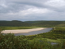
's largest plateau, with an area greater than 22,000 km². It lies at 300–500 meters above sea level. Approximately 36% of the Finnmark
Finnmark
or Finnmárku is a county in the extreme northeast of Norway. By land it borders Troms county to the west, Finland to the south and Russia to the east, and by water, the Norwegian Sea to the northwest, and the Barents Sea to the north and northeast.The county was formerly known as Finmarkens...
county lies in the Finnmarksvidda.
Geography
Alta, Norway
-Birdlife:For those interested in bird watching, the river outlet, known locally as Altaosen is well worth a visit. This tidal area is used as a stopover for many wetland species.-Transportation:...
in the west to Varanger Peninsula
Varanger Peninsula
Varanger Peninsula is a peninsula in Finnmark, north-eastern Norway, by the Barents Sea. The peninsula has the Tanafjord to the west, the Varangerfjord to the south and the Barents Sea to the north and east. Vadsø, Båtsfjord, Berlevåg, Vardø and Unjárga - Nesseby are the municipalities sharing the...
in the east it stretches for approximately 300 km, being at least that wide from north to south, extending into Finland
Finland
Finland , officially the Republic of Finland, is a Nordic country situated in the Fennoscandian region of Northern Europe. It is bordered by Sweden in the west, Norway in the north and Russia in the east, while Estonia lies to its south across the Gulf of Finland.Around 5.4 million people reside...
. The southeastern part of the plateau is protected by the Øvre Anárjohka National Park
Øvre Anarjóhka National Park
Øvre Anárjohka National Park lies in Karasjok and Kautokeino municipalities in Finnmark county, Norway. The park was opened in 1976 and is 1409 km² in area. It borders on Lemmenjoki National Park in Finland. Øvre Anárjohka is part of the Finnmark plateau and includes extensive birch woods, pine...
. The 1409 km² park opened in 1976.
Fauna and flora
The plateau includes extensive birchBirch
Birch is a tree or shrub of the genus Betula , in the family Betulaceae, closely related to the beech/oak family, Fagaceae. The Betula genus contains 30–60 known taxa...
woods, pine barrens
Pine barrens
Pine barrens, pine plains, sand plains, or pinelands occur throughout the northeastern U.S. from New Jersey to Maine as well as the Midwest and Canada....
, bog
Bog
A bog, quagmire or mire is a wetland that accumulates acidic peat, a deposit of dead plant material—often mosses or, in Arctic climates, lichens....
s and glacially formed lakes
Glacial lake
A glacial lake is a lake with origins in a melted glacier. Near the end of the last glacial period, roughly 10,000 years ago, glaciers began to retreat. A retreating glacier often left behind large deposits of ice in hollows between drumlins or hills. As the ice age ended, these melted to create...
. Finnmarksvidda is situated north of the Arctic Circle
Arctic Circle
The Arctic Circle is one of the five major circles of latitude that mark maps of the Earth. For Epoch 2011, it is the parallel of latitude that runs north of the Equator....
and is best known as the land of the once nomad
Nomad
Nomadic people , commonly known as itinerants in modern-day contexts, are communities of people who move from one place to another, rather than settling permanently in one location. There are an estimated 30-40 million nomads in the world. Many cultures have traditionally been nomadic, but...
ic Sami people
Sami people
The Sami people, also spelled Sámi, or Saami, are the arctic indigenous people inhabiting Sápmi, which today encompasses parts of far northern Sweden, Norway, Finland, the Kola Peninsula of Russia, and the border area between south and middle Sweden and Norway. The Sámi are Europe’s northernmost...
and their reindeer herds. Their shelters in the tundra
Tundra
In physical geography, tundra is a biome where the tree growth is hindered by low temperatures and short growing seasons. The term tundra comes through Russian тундра from the Kildin Sami word tūndâr "uplands," "treeless mountain tract." There are three types of tundra: Arctic tundra, alpine...
, are still in use in winter time.
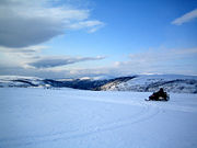
Climate
Finnmarksvidda, located in the interior of the county has a continental climateContinental climate
Continental climate is a climate characterized by important annual variation in temperature due to the lack of significant bodies of water nearby...
with the coldest winter temperatures in Norway: the coldest temperature ever recorded was -51.4 °C (-60.5 °F) in Karasjok
Karasjok
Kárášjohka or is a village and municipality in Finnmark county, Norway. The administrative centre of the municipality is the village of Karasjok.-Name:Karasjok is a Norwegianized form of the Sámi name Kárášjohka...
on 1 January 1886. The 24-hour averages for January and July in the same location are -17.1 °C (1.2 °F) and 13.1 °C (55.6 °F), while the yearly average is merely -2.4 °C (28 °F). Precipitation is only 366 mm (14.43 in) per year. Karasjok has recorded up to 32.4 °C (90.3 °F) in July, giving a possible yearly amplitude of 84 °C (151 °F), which is rare in Europe
Europe
Europe is, by convention, one of the world's seven continents. Comprising the westernmost peninsula of Eurasia, Europe is generally 'divided' from Asia to its east by the watershed divides of the Ural and Caucasus Mountains, the Ural River, the Caspian and Black Seas, and the waterways connecting...
. The annual mean temperatures on the plateau are as low as -3 °C (27 °F) (Sihcajavri in Kautokeino
Kautokeino
or Guovdageaidnu , is a municipality in Finnmark county, Norway. The administrative centre of the municipality is the village of Guovdageaidnu/Kautokeino...
), this being is the lowest average in mainland Norway (apart from the mountaintops) − lower even than that of Jan Mayen
Jan Mayen
Jan Mayen Island is a volcanic island in the Arctic Ocean and part of the Kingdom of Norway. It is long and 373 km2 in area, partly covered by glaciers . It has two parts: larger northeast Nord-Jan and smaller Sør-Jan, linked by an isthmus wide...
and Bjørnøya.