
Geography of Russia
Encyclopedia
Physical geography
Physical geography is one of the two major subfields of geography. Physical geography is that branch of natural science which deals with the study of processes and patterns in the natural environment like the atmosphere, biosphere and geosphere, as opposed to the cultural or built environment, the...
and human geography
Human geography
Human geography is one of the two major sub-fields of the discipline of geography. Human geography is the study of the world, its people, communities, and cultures. Human geography differs from physical geography mainly in that it has a greater focus on studying human activities and is more...
of Russia
Russia
Russia or , officially known as both Russia and the Russian Federation , is a country in northern Eurasia. It is a federal semi-presidential republic, comprising 83 federal subjects...
, a country extending over much of northern Eurasia
Eurasia
Eurasia is a continent or supercontinent comprising the traditional continents of Europe and Asia ; covering about 52,990,000 km2 or about 10.6% of the Earth's surface located primarily in the eastern and northern hemispheres...
. Comprising much of eastern Europe
Eastern Europe
Eastern Europe is the eastern part of Europe. The term has widely disparate geopolitical, geographical, cultural and socioeconomic readings, which makes it highly context-dependent and even volatile, and there are "almost as many definitions of Eastern Europe as there are scholars of the region"...
and northern Asia
North Asia
North Asia or Northern Asia is a subregion of Asia, consisting of the Asian portion of Russia.The Phillips Illustrated Atlas of the World 1988 defines it as being most of the former USSR, the part that is to the east of the Ural Mountains...
, it is the world's largest country in total area. Due to its size, Russia displays both monotony and diversity. As with its topography, its climates, vegetation, and soils span vast distances. From north to south the East European Plain
East European Plain
The East European Plain is a plain comprising a series of river basins in Eastern Europe. Together with the Northern European Plain it constitutes the European Plain. It is the largest mountain-free part of the European landscape.The plain spans approximately and averages about in elevation...
is clad sequentially in tundra
Tundra
In physical geography, tundra is a biome where the tree growth is hindered by low temperatures and short growing seasons. The term tundra comes through Russian тундра from the Kildin Sami word tūndâr "uplands," "treeless mountain tract." There are three types of tundra: Arctic tundra, alpine...
, coniferous forest (taiga
Taiga
Taiga , also known as the boreal forest, is a biome characterized by coniferous forests.Taiga is the world's largest terrestrial biome. In North America it covers most of inland Canada and Alaska as well as parts of the extreme northern continental United States and is known as the Northwoods...
), mixed and broad-leaf forests, grassland (steppe
Steppe
In physical geography, steppe is an ecoregion, in the montane grasslands and shrublands and temperate grasslands, savannas, and shrublands biomes, characterized by grassland plains without trees apart from those near rivers and lakes...
), and semi-desert (fringing the Caspian Sea
Caspian Sea
The Caspian Sea is the largest enclosed body of water on Earth by area, variously classed as the world's largest lake or a full-fledged sea. The sea has a surface area of and a volume of...
) as the changes in vegetation reflect the changes in climate. Siberia
Siberia
Siberia is an extensive region constituting almost all of Northern Asia. Comprising the central and eastern portion of the Russian Federation, it was part of the Soviet Union from its beginning, as its predecessor states, the Tsardom of Russia and the Russian Empire, conquered it during the 16th...
supports a similar sequence but is taiga. The country contains 40 UNESCO Biosphere reserve
Biosphere reserve
The Man and the Biosphere Programme of UNESCO was established in 1971 to promote interdisciplinary approaches to management, research and education in ecosystem conservation and sustainable use of natural resources.-Development:...
s.
Global position and boundaries
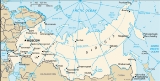
Located in the northern and middle latitudes a of the Northern Hemisphere, most of Russia is much closer to the North Pole than to the equator. Individual country comparisons are of little value in gauging Russia's enormous size and diversity. The country's 17.1 million square kilometers include one-eighth of the Earth's inhabited land area. Its European portion, which occupies a substantial part of continental Europe, is home to most of Russia's industrial and agricultural activity. It was here, roughly between the Dnieper River and the Ural Mountains, that the Russian Empire took shape. It is also located on the northernmost tip of Asia.From west to east, the country stretches from Kaliningrad
Kaliningrad Oblast
Kaliningrad Oblast is a federal subject of Russia situated on the Baltic coast. It has a population of The oblast forms the westernmost part of the Russian Federation, but it has no land connection to the rest of Russia. Since its creation it has been an exclave of the Russian SFSR and then the...
(the exclave separated by the 1990 secession of Lithuania from the then-Soviet Union
Soviet Union
The Soviet Union , officially the Union of Soviet Socialist Republics , was a constitutionally socialist state that existed in Eurasia between 1922 and 1991....
) to Ratmanov Island (one of the Diomede Islands
Diomede Islands
The Diomede Islands , also known in Russia as Gvozdev Islands , consist of two rocky, tuya-like islands:* The U.S. island of Little Diomede or, in its native language, Ignaluk , and* The Russian island of Big Diomede , also known as Imaqliq,...
) in the Bering Strait
Bering Strait
The Bering Strait , known to natives as Imakpik, is a sea strait between Cape Dezhnev, Chukotka Autonomous Okrug, Russia, the easternmost point of the Asian continent and Cape Prince of Wales, Alaska, USA, the westernmost point of the North American continent, with latitude of about 65°40'N,...
. This distance is roughly equivalent to the distance from Edinburgh
Edinburgh
Edinburgh is the capital city of Scotland, the second largest city in Scotland, and the eighth most populous in the United Kingdom. The City of Edinburgh Council governs one of Scotland's 32 local government council areas. The council area includes urban Edinburgh and a rural area...
, Scotland
Scotland
Scotland is a country that is part of the United Kingdom. Occupying the northern third of the island of Great Britain, it shares a border with England to the south and is bounded by the North Sea to the east, the Atlantic Ocean to the north and west, and the North Channel and Irish Sea to the...
, to Nome
Nome, Alaska
Nome is a city in the Nome Census Area in the Unorganized Borough of the U.S. state of Alaska, located on the southern Seward Peninsula coast on Norton Sound of the Bering Sea. According to the 2010 Census, the city population was 3,598. Nome was incorporated on April 9, 1901, and was once the...
, Alaska
Alaska
Alaska is the largest state in the United States by area. It is situated in the northwest extremity of the North American continent, with Canada to the east, the Arctic Ocean to the north, and the Pacific Ocean to the west and south, with Russia further west across the Bering Strait...
. From north to south, the country ranges from the northern tip of the Russian Arctic islands
Russian Arctic islands
The Russian Arctic islands are a number of islands groups and sole islands scattered around the Arctic Ocean.-Geography:The islands are all situated within the Arctic Circle and are scattered through the marginal seas of the Arctic ocean namely the Barents Sea, Kara Sea, Laptev Sea, East Siberian...
at Franz Josef Land
Franz Josef Land
Franz Josef Land, Franz Joseph Land, or Francis Joseph's Land is an archipelago located in the far north of Russia. It is found in the Arctic Ocean north of Novaya Zemlya and east of Svalbard, and is administered by Arkhangelsk Oblast. Franz Josef Land consists of 191 ice-covered islands with a...
to the southern tip of the Republic of Dagestan
Dagestan
The Republic of Dagestan is a federal subject of Russia, located in the North Caucasus region. Its capital and the largest city is Makhachkala, located at the center of Dagestan on the Caspian Sea...
on the Caspian Sea
Caspian Sea
The Caspian Sea is the largest enclosed body of water on Earth by area, variously classed as the world's largest lake or a full-fledged sea. The sea has a surface area of and a volume of...
, spanning about 4,500 kilometers of extremely varied, often inhospitable terrain.
Extending for 57,792 kilometers, the Russian border
Border
Borders define geographic boundaries of political entities or legal jurisdictions, such as governments, sovereign states, federated states and other subnational entities. Some borders—such as a state's internal administrative borders, or inter-state borders within the Schengen Area—are open and...
is the world's longest, a source of substantial concern for national security in the post-Soviet
Soviet Union
The Soviet Union , officially the Union of Soviet Socialist Republics , was a constitutionally socialist state that existed in Eurasia between 1922 and 1991....
era. Along the 20,139-kilometer land frontier, Russia has boundaries with 14 countries: Norway
Norway
Norway , officially the Kingdom of Norway, is a Nordic unitary constitutional monarchy whose territory comprises the western portion of the Scandinavian Peninsula, Jan Mayen, and the Arctic archipelago of Svalbard and Bouvet Island. Norway has a total area of and a population of about 4.9 million...
, Finland
Finland
Finland , officially the Republic of Finland, is a Nordic country situated in the Fennoscandian region of Northern Europe. It is bordered by Sweden in the west, Norway in the north and Russia in the east, while Estonia lies to its south across the Gulf of Finland.Around 5.4 million people reside...
, Estonia
Estonia
Estonia , officially the Republic of Estonia , is a state in the Baltic region of Northern Europe. It is bordered to the north by the Gulf of Finland, to the west by the Baltic Sea, to the south by Latvia , and to the east by Lake Peipsi and the Russian Federation . Across the Baltic Sea lies...
, Latvia
Latvia
Latvia , officially the Republic of Latvia , is a country in the Baltic region of Northern Europe. It is bordered to the north by Estonia , to the south by Lithuania , to the east by the Russian Federation , to the southeast by Belarus and shares maritime borders to the west with Sweden...
, Lithuania
Lithuania
Lithuania , officially the Republic of Lithuania is a country in Northern Europe, the biggest of the three Baltic states. It is situated along the southeastern shore of the Baltic Sea, whereby to the west lie Sweden and Denmark...
, Poland
Poland
Poland , officially the Republic of Poland , is a country in Central Europe bordered by Germany to the west; the Czech Republic and Slovakia to the south; Ukraine, Belarus and Lithuania to the east; and the Baltic Sea and Kaliningrad Oblast, a Russian exclave, to the north...
(via the Kaliningrad Oblast
Kaliningrad Oblast
Kaliningrad Oblast is a federal subject of Russia situated on the Baltic coast. It has a population of The oblast forms the westernmost part of the Russian Federation, but it has no land connection to the rest of Russia. Since its creation it has been an exclave of the Russian SFSR and then the...
), Belarus
Belarus
Belarus , officially the Republic of Belarus, is a landlocked country in Eastern Europe, bordered clockwise by Russia to the northeast, Ukraine to the south, Poland to the west, and Lithuania and Latvia to the northwest. Its capital is Minsk; other major cities include Brest, Grodno , Gomel ,...
, Ukraine
Ukraine
Ukraine is a country in Eastern Europe. It has an area of 603,628 km², making it the second largest contiguous country on the European continent, after Russia...
, Georgia
Georgia (country)
Georgia is a sovereign state in the Caucasus region of Eurasia. Located at the crossroads of Western Asia and Eastern Europe, it is bounded to the west by the Black Sea, to the north by Russia, to the southwest by Turkey, to the south by Armenia, and to the southeast by Azerbaijan. The capital of...
, Abkhazia
Abkhazia
Abkhazia is a disputed political entity on the eastern coast of the Black Sea and the south-western flank of the Caucasus.Abkhazia considers itself an independent state, called the Republic of Abkhazia or Apsny...
, South Ossetia
South Ossetia
South Ossetia or Tskhinvali Region is a disputed region and partly recognized state in the South Caucasus, located in the territory of the South Ossetian Autonomous Oblast within the former Georgian Soviet Socialist Republic....
, Azerbaijan
Azerbaijan
Azerbaijan , officially the Republic of Azerbaijan is the largest country in the Caucasus region of Eurasia. Located at the crossroads of Western Asia and Eastern Europe, it is bounded by the Caspian Sea to the east, Russia to the north, Georgia to the northwest, Armenia to the west, and Iran to...
, Kazakhstan
Kazakhstan
Kazakhstan , officially the Republic of Kazakhstan, is a transcontinental country in Central Asia and Eastern Europe. Ranked as the ninth largest country in the world, it is also the world's largest landlocked country; its territory of is greater than Western Europe...
, Mongolia
Mongolia
Mongolia is a landlocked country in East and Central Asia. It is bordered by Russia to the north and China to the south, east and west. Although Mongolia does not share a border with Kazakhstan, its western-most point is only from Kazakhstan's eastern tip. Ulan Bator, the capital and largest...
, the People's Republic of China
People's Republic of China
China , officially the People's Republic of China , is the most populous country in the world, with over 1.3 billion citizens. Located in East Asia, the country covers approximately 9.6 million square kilometres...
and North Korea
North Korea
The Democratic People’s Republic of Korea , , is a country in East Asia, occupying the northern half of the Korean Peninsula. Its capital and largest city is Pyongyang. The Korean Demilitarized Zone serves as the buffer zone between North Korea and South Korea...
.
Approximately 2/3 of the frontier is bounded by water. Virtually all of the lengthy northern coast is well above the Arctic Circle
Arctic Circle
The Arctic Circle is one of the five major circles of latitude that mark maps of the Earth. For Epoch 2011, it is the parallel of latitude that runs north of the Equator....
; except for the port of Murmansk
Murmansk
Murmansk is a city and the administrative center of Murmansk Oblast, Russia. It serves as a seaport and is located in the extreme northwest part of Russia, on the Kola Bay, from the Barents Sea on the northern shore of the Kola Peninsula, not far from Russia's borders with Norway and Finland...
—which receives currents that are somewhat warmer than would be expected at that latitude, due to the effects of the Gulf Stream
Gulf Stream
The Gulf Stream, together with its northern extension towards Europe, the North Atlantic Drift, is a powerful, warm, and swift Atlantic ocean current that originates at the tip of Florida, and follows the eastern coastlines of the United States and Newfoundland before crossing the Atlantic Ocean...
—that coast is locked in ice much of the year. Thirteen seas and parts of three oceans—the Arctic
Arctic Ocean
The Arctic Ocean, located in the Northern Hemisphere and mostly in the Arctic north polar region, is the smallest and shallowest of the world's five major oceanic divisions...
, Atlantic
Atlantic Ocean
The Atlantic Ocean is the second-largest of the world's oceanic divisions. With a total area of about , it covers approximately 20% of the Earth's surface and about 26% of its water surface area...
, and Pacific
Pacific Ocean
The Pacific Ocean is the largest of the Earth's oceanic divisions. It extends from the Arctic in the north to the Southern Ocean in the south, bounded by Asia and Australia in the west, and the Americas in the east.At 165.2 million square kilometres in area, this largest division of the World...
—wash Russian shores.
Russia shares a maritime boundary
Maritime boundary
Maritime boundary is a conceptual means of division of the water surface of the planet into maritime areas that are defined through surrounding physical geography or by human geography. As such it usually includes areas of exclusive national rights over the mineral and biological resources,...
with the United States and with Japan—see Russia-United States maritime boundary
Russia-United States maritime boundary
The Russia – United States maritime boundary de facto follows the June 1, 1990 USA/USSR Maritime Boundary Agreement , but it has yet to be approved by the Russian parliament...
; Russia-Japan maritime boundary.
Administrative and territorial divisions
With a few changes of status, most of the Soviet-era administrative and territorial divisions of the Russian Republic were retained in constituting the Russian Federation. In 2006, there were eighty-eight administrative territorial divisions (called federal subjectsFederal subjects of Russia
Russia is a federation which, since March 1, 2008, consists of 83 federal subjects . In 1993, when the Constitution was adopted, there were 89 federal subjects listed...
): twenty-one republics, seven krai
Krai
Krai or kray was a type of an administrative division in the Russian Empire and the Russian SFSR, and is one of the types of the federal subjects of modern Russia ....
s (territories), forty-eight oblast
Oblast
Oblast is a type of administrative division in Slavic countries, including some countries of the former Soviet Union. The word "oblast" is a loanword in English, but it is nevertheless often translated as "area", "zone", "province", or "region"...
s (provinces), one autonomous oblast
Autonomous oblast
An autonomous oblast is an autonomous entity within the state which is on the oblast level of the overall administrative subdivision. It may refer to:*Autonomous oblasts of the Soviet Union*Autonomous oblasts of Russia...
, and nine autonomous okrug
Okrug
Okrug is an administrative division of some Slavic states. The word "okrug" is a loanword in English, but it is nevertheless often translated as "area", "district", or "region"....
s. The cities of Moscow
Moscow
Moscow is the capital, the most populous city, and the most populous federal subject of Russia. The city is a major political, economic, cultural, scientific, religious, financial, educational, and transportation centre of Russia and the continent...
and Saint Petersburg
Saint Petersburg
Saint Petersburg is a city and a federal subject of Russia located on the Neva River at the head of the Gulf of Finland on the Baltic Sea...
also have federal status
Federal cities of Russia
The Russian Federation is divided into 83 federal subjects, two of which are federal cities....
.
The republics include a wide variety of peoples, including northern Europeans, Tatars
Tatars
Tatars are a Turkic speaking ethnic group , numbering roughly 7 million.The majority of Tatars live in the Russian Federation, with a population of around 5.5 million, about 2 million of which in the republic of Tatarstan.Significant minority populations are found in Uzbekistan, Kazakhstan,...
, Caucasus
Caucasus
The Caucasus, also Caucas or Caucasia , is a geopolitical region at the border of Europe and Asia, and situated between the Black and the Caspian sea...
peoples, and indigenous Siberians. The largest federal subjects are in Siberia. Located in east-central Siberia, the Sakha Republic (Yakutia) is the largest federal subject in the country (and the largest country subdivision in the world), twice the size of Alaska. Second in size is Krasnoyarsk Krai
Krasnoyarsk Krai
Krasnoyarsk Krai is a federal subject of Russia . It is the second largest federal subject after the Sakha Republic, and Russia's largest krai, occupying an area of , which is 13% of the country's total territory. The administrative center of the krai is the city of Krasnoyarsk...
, located west of Sakha in Siberia. Kaliningrad Oblast
Kaliningrad Oblast
Kaliningrad Oblast is a federal subject of Russia situated on the Baltic coast. It has a population of The oblast forms the westernmost part of the Russian Federation, but it has no land connection to the rest of Russia. Since its creation it has been an exclave of the Russian SFSR and then the...
is the smallest oblast, and it is the only noncontiguous part of Russia. The two most populous federal subjects, Moscow Oblast
Moscow Oblast
Moscow Oblast , or Podmoskovye , is a federal subject of Russia . Its area, at , is relatively small compared to other federal subjects, but it is one of the most densely populated regions in the country and, with the 2010 population of 7,092,941, is the second most populous federal subject...
(with Moscow) and Krasnodar Krai
Krasnodar Krai
-External links:* **...
, are in European Russia.
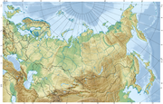
Topography and drainage
Geographers traditionally divide the vast territory of Russia into five natural zones: the tundraTundra
In physical geography, tundra is a biome where the tree growth is hindered by low temperatures and short growing seasons. The term tundra comes through Russian тундра from the Kildin Sami word tūndâr "uplands," "treeless mountain tract." There are three types of tundra: Arctic tundra, alpine...
zone; the taiga
Taiga
Taiga , also known as the boreal forest, is a biome characterized by coniferous forests.Taiga is the world's largest terrestrial biome. In North America it covers most of inland Canada and Alaska as well as parts of the extreme northern continental United States and is known as the Northwoods...
, or forest, zone; the steppe
Steppe
In physical geography, steppe is an ecoregion, in the montane grasslands and shrublands and temperate grasslands, savannas, and shrublands biomes, characterized by grassland plains without trees apart from those near rivers and lakes...
, or plains, zone; the arid zone
Desert
A desert is a landscape or region that receives an extremely low amount of precipitation, less than enough to support growth of most plants. Most deserts have an average annual precipitation of less than...
; and the mountain
Mountain
Image:Himalaya_annotated.jpg|thumb|right|The Himalayan mountain range with Mount Everestrect 58 14 160 49 Chomo Lonzorect 200 28 335 52 Makalurect 378 24 566 45 Mount Everestrect 188 581 920 656 Tibetan Plateaurect 250 406 340 427 Rong River...
zone. Most of Russia consists of two plain
Plain
In geography, a plain is land with relatively low relief, that is flat or gently rolling. Prairies and steppes are types of plains, and the archetype for a plain is often thought of as a grassland, but plains in their natural state may also be covered in shrublands, woodland and forest, or...
s (the East European Plain
East European Plain
The East European Plain is a plain comprising a series of river basins in Eastern Europe. Together with the Northern European Plain it constitutes the European Plain. It is the largest mountain-free part of the European landscape.The plain spans approximately and averages about in elevation...
and the West Siberian Plain
West Siberian Plain
The West Siberian Plain is a large plain that occupies the western portion of Siberia, between the Ural Mountains in the west and the Yenisei River in the east, and by the Altay Mountains on the South-East. Much of the plain is poorly drained and consists of some of the world's largest swamps and...
), two lowland
Lowland
In physical geography, a lowland is any broad expanse of land with a general low level. The term is thus applied to the landward portion of the upward slope from oceanic depths to continental highlands, to a region of depression in the interior of a mountainous region, to a plain of denudation, or...
s (the North Siberian and the Kolyma, in far northeastern Siberia), two plateau
Plateau
In geology and earth science, a plateau , also called a high plain or tableland, is an area of highland, usually consisting of relatively flat terrain. A highly eroded plateau is called a dissected plateau...
s (the Central Siberian Plateau
Central Siberian Plateau
The Central Siberian Plateau is made up of sharply demarcated surfaces of varying altitudes occupying most of Siberia between the Yenisei and Lena rivers. It extends over an area of 3.5 million km². The highest point is the Putoran Mountains rising to 1701 m. To the north of the plateau are...
and the Lena Plateau to its east), and a series of mountainous areas mainly concentrated in the extreme northeast or extending intermittently along the southern border.
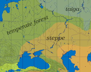
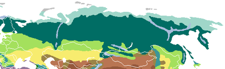
Ecoregions
 |
East European plain
The East European PlainEast European Plain
The East European Plain is a plain comprising a series of river basins in Eastern Europe. Together with the Northern European Plain it constitutes the European Plain. It is the largest mountain-free part of the European landscape.The plain spans approximately and averages about in elevation...
encompasses most of European Russia
European Russia
European Russia refers to the western areas of Russia that lie within Europe, comprising roughly 3,960,000 square kilometres , larger in area than India, and spanning across 40% of Europe. Its eastern border is defined by the Ural Mountains and in the south it is defined by the border with...
. The West Siberian Plain
West Siberian Plain
The West Siberian Plain is a large plain that occupies the western portion of Siberia, between the Ural Mountains in the west and the Yenisei River in the east, and by the Altay Mountains on the South-East. Much of the plain is poorly drained and consists of some of the world's largest swamps and...
, which is the world's largest, extends east from the Urals
Ural Mountains
The Ural Mountains , or simply the Urals, are a mountain range that runs approximately from north to south through western Russia, from the coast of the Arctic Ocean to the Ural River and northwestern Kazakhstan. Their eastern side is usually considered the natural boundary between Europe and Asia...
to the Yenisei River
Yenisei River
Yenisei , also written as Yenisey, is the largest river system flowing to the Arctic Ocean. It is the central of the three great Siberian rivers that flow into the Arctic Ocean...
. Because the terrain and vegetation are relatively uniform in each of the natural zones, Russia presents an illusion of uniformity. Nevertheless, Russian territory contains all the major vegetation zones of the world except a tropical rain forest
Tropical and subtropical moist broadleaf forests
Tropical and subtropical moist broadleaf forests , also known as tropical moist forests, are a tropical and subtropical forest biome....
.
Tundra
The Russian Arctic stretches for close to 7,000 km west to east, from Karelia
Karelia
Karelia , the land of the Karelian peoples, is an area in Northern Europe of historical significance for Finland, Russia, and Sweden...
and the Kola Peninsula
Kola Peninsula
The Kola Peninsula is a peninsula in the far northwest of Russia. Constituting the bulk of the territory of Murmansk Oblast, it lies almost completely to the north of the Arctic Circle and is washed by the Barents Sea in the north and the White Sea in the east and southeast...
to Nenetsia, the Gulf of Ob
Gulf of Ob
The Gulf of Ob is a gigantic bay of the Arctic Ocean, located in Northern Russia at the head the mouth of the Ob River....
, the Taymyr Peninsula
Taymyr Peninsula
The Taymyr Peninsula is a peninsula in the Far North of Russia, in the Siberian Federal District, that forms the northernmost part of mainland Eurasia and Asia...
and the Chukchi Peninsula
Chukchi Peninsula
The Chukchi Peninsula, Chukotka Peninsula or Chukotski Peninsula , at about 66° N 172° W, is the northeastern extremity of Asia. Its eastern end is at Cape Dezhnev near the village of Uelen. It is bordered by the Chukchi Sea to the north, the Bering Sea to the south, and the Bering Strait to the...
(Kolyma
Kolyma
The Kolyma region is located in the far north-eastern area of Russia in what is commonly known as Siberia but is actually part of the Russian Far East. It is bounded by the East Siberian Sea and the Arctic Ocean in the north and the Sea of Okhotsk to the south...
, Anadyr River
Anadyr River
Anadyr is a river in the far northeast Siberia which flows into Anadyr Bay of the Bering Sea and drains much of the interior of Chukotka Autonomous Okrug. Its basin corresponds to the Anadyrsky District of Chukotka....
, Cape Dezhnev
Cape Dezhnev
Cape Dezhnyov or Cape Dezhnev is a cape that forms the eastmost mainland point of Eurasia. It is located on the Chukchi Peninsula in the very thinly populated Chukotka Autonomous Okrug of Russia. This cape is located between the Bering Sea and the Chukchi Sea, across from Cape Prince of Wales in...
). Russian islands and archipelagos in the Arctic Sea include Novaya Zemlya
Novaya Zemlya
Novaya Zemlya , also known in Dutch as Nova Zembla and in Norwegian as , is an archipelago in the Arctic Ocean in the north of Russia and the extreme northeast of Europe, the easternmost point of Europe lying at Cape Flissingsky on the northern island...
, Severnaya Zemlya
Severnaya Zemlya
Severnaya Zemlya is an archipelago in the Russian high Arctic at around . It is located off mainland Siberia's Taymyr Peninsula across the Vilkitsky Strait...
, and the New Siberian Islands
New Siberian Islands
The New Siberian Islands are an archipelago, located to the North of the East Siberian coast between the Laptev Sea and the East Siberian Sea north of the Sakha Republic....
.
About 11% of Russia is tundra
Tundra
In physical geography, tundra is a biome where the tree growth is hindered by low temperatures and short growing seasons. The term tundra comes through Russian тундра from the Kildin Sami word tūndâr "uplands," "treeless mountain tract." There are three types of tundra: Arctic tundra, alpine...
—a treeless, marshy plain. The tundra is Russia's northernmost zone, stretching from the Finnish
Finland
Finland , officially the Republic of Finland, is a Nordic country situated in the Fennoscandian region of Northern Europe. It is bordered by Sweden in the west, Norway in the north and Russia in the east, while Estonia lies to its south across the Gulf of Finland.Around 5.4 million people reside...
border in the west to the Bering Strait
Bering Strait
The Bering Strait , known to natives as Imakpik, is a sea strait between Cape Dezhnev, Chukotka Autonomous Okrug, Russia, the easternmost point of the Asian continent and Cape Prince of Wales, Alaska, USA, the westernmost point of the North American continent, with latitude of about 65°40'N,...
in the east, then running south along the Pacific
Pacific Ocean
The Pacific Ocean is the largest of the Earth's oceanic divisions. It extends from the Arctic in the north to the Southern Ocean in the south, bounded by Asia and Australia in the west, and the Americas in the east.At 165.2 million square kilometres in area, this largest division of the World...
coast to the northern Kamchatka Peninsula
Kamchatka Peninsula
The Kamchatka Peninsula is a peninsula in the Russian Far East, with an area of . It lies between the Pacific Ocean to the east and the Sea of Okhotsk to the west...
. The zone is known for its herds of wild reindeer
Reindeer
The reindeer , also known as the caribou in North America, is a deer from the Arctic and Subarctic, including both resident and migratory populations. While overall widespread and numerous, some of its subspecies are rare and one has already gone extinct.Reindeer vary considerably in color and size...
, for so-called white nights (dusk at midnight, dawn shortly thereafter) in summer, and for days of total darkness in winter. The long, harsh winters and lack of sunshine allow only moss
Moss
Mosses are small, soft plants that are typically 1–10 cm tall, though some species are much larger. They commonly grow close together in clumps or mats in damp or shady locations. They do not have flowers or seeds, and their simple leaves cover the thin wiry stems...
es, lichen
Lichen
Lichens are composite organisms consisting of a symbiotic organism composed of a fungus with a photosynthetic partner , usually either a green alga or cyanobacterium...
s, and dwarf willows
Dwarf Willow
Salix herbacea is a species of tiny creeping willow adapted to survive in harsh Arctic and sub-Arctic environments...
and shrubs to sprout low above the barren permafrost
Permafrost
In geology, permafrost, cryotic soil or permafrost soil is soil at or below the freezing point of water for two or more years. Ice is not always present, as may be in the case of nonporous bedrock, but it frequently occurs and it may be in amounts exceeding the potential hydraulic saturation of...
. Although several powerful Siberian rivers traverse this zone as they flow northward to the Arctic Ocean, partial and intermittent thawing hamper drainage of the numerous lakes, ponds, and swamps of the tundra. Frost weathering is the most important physical process here, gradually shaping a landscape that was severely modified by glaciation in the last ice age
Ice age
An ice age or, more precisely, glacial age, is a generic geological period of long-term reduction in the temperature of the Earth's surface and atmosphere, resulting in the presence or expansion of continental ice sheets, polar ice sheets and alpine glaciers...
. Less than 1% of Russia's population lives in this zone. The fishing and port industries of the northwestern Kola Peninsula
Kola Peninsula
The Kola Peninsula is a peninsula in the far northwest of Russia. Constituting the bulk of the territory of Murmansk Oblast, it lies almost completely to the north of the Arctic Circle and is washed by the Barents Sea in the north and the White Sea in the east and southeast...
and the huge oil
Petroleum
Petroleum or crude oil is a naturally occurring, flammable liquid consisting of a complex mixture of hydrocarbons of various molecular weights and other liquid organic compounds, that are found in geologic formations beneath the Earth's surface. Petroleum is recovered mostly through oil drilling...
and gas
Natural gas
Natural gas is a naturally occurring gas mixture consisting primarily of methane, typically with 0–20% higher hydrocarbons . It is found associated with other hydrocarbon fuel, in coal beds, as methane clathrates, and is an important fuel source and a major feedstock for fertilizers.Most natural...
fields of northwestern Siberia are the largest employers in the tundra. With a population of 180,000, the industrial frontier city of Norilsk
Norilsk
Norilsk is an industrial city in Krasnoyarsk Krai, Russia, located between the Yenisei River and the Taymyr Peninsula. Population: It was granted city status in 1953. It is the northernmost city in Siberia and the world's second largest city north of the Arctic Circle...
is second in population to Murmansk
Murmansk
Murmansk is a city and the administrative center of Murmansk Oblast, Russia. It serves as a seaport and is located in the extreme northwest part of Russia, on the Kola Bay, from the Barents Sea on the northern shore of the Kola Peninsula, not far from Russia's borders with Norway and Finland...
among Russia's settlements above the Arctic Circle. From here you can also see the arouras (northern lights
Aurora (astronomy)
An aurora is a natural light display in the sky particularly in the high latitude regions, caused by the collision of energetic charged particles with atoms in the high altitude atmosphere...
).
Taiga
Taiga
Taiga , also known as the boreal forest, is a biome characterized by coniferous forests.Taiga is the world's largest terrestrial biome. In North America it covers most of inland Canada and Alaska as well as parts of the extreme northern continental United States and is known as the Northwoods...
, which is the world's largest forest region, contains mostly coniferous
Pinophyta
The conifers, division Pinophyta, also known as division Coniferophyta or Coniferae, are one of 13 or 14 division level taxa within the Kingdom Plantae. Pinophytes are gymnosperms. They are cone-bearing seed plants with vascular tissue; all extant conifers are woody plants, the great majority being...
spruce
Spruce
A spruce is a tree of the genus Picea , a genus of about 35 species of coniferous evergreen trees in the Family Pinaceae, found in the northern temperate and boreal regions of the earth. Spruces are large trees, from tall when mature, and can be distinguished by their whorled branches and conical...
, fir
Fir
Firs are a genus of 48–55 species of evergreen conifers in the family Pinaceae. They are found through much of North and Central America, Europe, Asia, and North Africa, occurring in mountains over most of the range...
, pine
Pine
Pines are trees in the genus Pinus ,in the family Pinaceae. They make up the monotypic subfamily Pinoideae. There are about 115 species of pine, although different authorities accept between 105 and 125 species.-Etymology:...
, and larch
Larch
Larches are conifers in the genus Larix, in the family Pinaceae. Growing from 15 to 50m tall, they are native to much of the cooler temperate northern hemisphere, on lowlands in the north and high on mountains further south...
. This is the largest natural zone of Russia, an area about the size of the United States. In the northeastern portion of this belt, long and severe winters frequently bring the world's coldest temperatures for inhabited areas. The taiga zone extends in a broad band across the middle latitudes, stretching from the Finnish border in the west to the Verkhoyansk Range
Verkhoyansk Range
thumb|right|The Verkhoyansk Range is the L-shaped area east of the LenaThe Verkhoyansk Range is a mountain range of eastern Siberia, spanning ca. 1000 km , across the Sakha Republic. It forms a vast arc between the Lena and Aldan rivers to the west and the Yana River to the east. It rises to ca....
in northeastern Siberia and as far south as the southern shores of Lake Baikal
Lake Baikal
Lake Baikal is the world's oldest at 30 million years old and deepest lake with an average depth of 744.4 metres.Located in the south of the Russian region of Siberia, between Irkutsk Oblast to the northwest and the Buryat Republic to the southeast, it is the most voluminous freshwater lake in the...
. Isolated sections of taiga also exist along mountain ranges such as the southern part of the Urals and in the Amur River valley bordering China in the Far East
Far East
The Far East is an English term mostly describing East Asia and Southeast Asia, with South Asia sometimes also included for economic and cultural reasons.The term came into use in European geopolitical discourse in the 19th century,...
. About 33% of Russia's population lives in this zone, which, together with a band of mixed forest
Temperate broadleaf and mixed forests
Mixed forests are a temperate and humid biome. The typical structure of these forests includes four layers. The uppermost layer is the canopy composed of tall mature trees ranging from 33 to 66 m high. Below the canopy is the three-layered, shade-tolerant understory that is roughly 9 to...
to its south, includes most of the European part of Russia and the ancestral lands of the earliest Slavic settlers.
Mixed and Deciduous forest
The mixed and deciduous forest belt is triangular, widest along the western border and narrower towards the Ural MountainsUral Mountains
The Ural Mountains , or simply the Urals, are a mountain range that runs approximately from north to south through western Russia, from the coast of the Arctic Ocean to the Ural River and northwestern Kazakhstan. Their eastern side is usually considered the natural boundary between Europe and Asia...
. The main trees are Oak
Oak
An oak is a tree or shrub in the genus Quercus , of which about 600 species exist. "Oak" may also appear in the names of species in related genera, notably Lithocarpus...
and Spruce
Spruce
A spruce is a tree of the genus Picea , a genus of about 35 species of coniferous evergreen trees in the Family Pinaceae, found in the northern temperate and boreal regions of the earth. Spruces are large trees, from tall when mature, and can be distinguished by their whorled branches and conical...
, but many other growths of vegetation such as ash
Ash tree
Fraxinus is a genus flowering plants in the olive and lilac family, Oleaceae. It contains 45-65 species of usually medium to large trees, mostly deciduous though a few subtropical species are evergreen. The tree's common English name, ash, goes back to the Old English æsc, while the generic name...
, aspen
Aspen
Populus section Populus, of the Populus genus, includes the aspen trees and the white poplar Populus alba. The five typical aspens are all native to cold regions with cool summers, in the north of the Northern Hemisphere, extending south at high altitudes in the mountains. The White Poplar, by...
, birch
Birch
Birch is a tree or shrub of the genus Betula , in the family Betulaceae, closely related to the beech/oak family, Fagaceae. The Betula genus contains 30–60 known taxa...
, hornbeam
Hornbeam
Hornbeams are relatively small hardwood trees in the genus Carpinus . Though some botanists grouped them with the hazels and hop-hornbeams in a segregate family, Corylaceae, modern botanists place the hornbeams in the birch subfamily Coryloideae...
, maple
Maple
Acer is a genus of trees or shrubs commonly known as maple.Maples are variously classified in a family of their own, the Aceraceae, or together with the Hippocastanaceae included in the family Sapindaceae. Modern classifications, including the Angiosperm Phylogeny Group system, favour inclusion in...
, and pine
Pine
Pines are trees in the genus Pinus ,in the family Pinaceae. They make up the monotypic subfamily Pinoideae. There are about 115 species of pine, although different authorities accept between 105 and 125 species.-Etymology:...
reside there. Separating the taiga from the wooded steppe is a narrow belt of birch and aspen woodland located east of the Urals as far as the Altay Mountains
Altay Mountains
The Altai Mountains are a mountain range in East-Central Asia, where Russia, China, Mongolia and Kazakhstan come together, and where the rivers Irtysh and Ob have their sources. The Altai Mountains are known as the original locus of the speakers of Turkic as well as other members of the proposed...
. Much of the forested zone has been cleared for agriculture
Agriculture
Agriculture is the cultivation of animals, plants, fungi and other life forms for food, fiber, and other products used to sustain life. Agriculture was the key implement in the rise of sedentary human civilization, whereby farming of domesticated species created food surpluses that nurtured the...
, especially in European Russia
European Russia
European Russia refers to the western areas of Russia that lie within Europe, comprising roughly 3,960,000 square kilometres , larger in area than India, and spanning across 40% of Europe. Its eastern border is defined by the Ural Mountains and in the south it is defined by the border with...
. Wildlife is more scarce as a result of this, but the roe deer
Roe Deer
The European Roe Deer , also known as the Western Roe Deer, chevreuil or just Roe Deer, is a Eurasian species of deer. It is relatively small, reddish and grey-brown, and well-adapted to cold environments. Roe Deer are widespread in Western Europe, from the Mediterranean to Scandinavia, and from...
, wolf, fox
Fox
Fox is a common name for many species of omnivorous mammals belonging to the Canidae family. Foxes are small to medium-sized canids , characterized by possessing a long narrow snout, and a bushy tail .Members of about 37 species are referred to as foxes, of which only 12 species actually belong to...
, and squirrel
Squirrel
Squirrels belong to a large family of small or medium-sized rodents called the Sciuridae. The family includes tree squirrels, ground squirrels, chipmunks, marmots , flying squirrels, and prairie dogs. Squirrels are indigenous to the Americas, Eurasia, and Africa and have been introduced to Australia...
are very common.
Steppe
The steppeSteppe
In physical geography, steppe is an ecoregion, in the montane grasslands and shrublands and temperate grasslands, savannas, and shrublands biomes, characterized by grassland plains without trees apart from those near rivers and lakes...
has long been depicted as the typical Russian landscape. It is a broad band of treeless, grassy plains, interrupted by mountain ranges, extending from Hungary
Hungary
Hungary , officially the Republic of Hungary , is a landlocked country in Central Europe. It is situated in the Carpathian Basin and is bordered by Slovakia to the north, Ukraine and Romania to the east, Serbia and Croatia to the south, Slovenia to the southwest and Austria to the west. The...
across Ukraine
Ukraine
Ukraine is a country in Eastern Europe. It has an area of 603,628 km², making it the second largest contiguous country on the European continent, after Russia...
, southern Russia, and Kazakhstan
Kazakhstan
Kazakhstan , officially the Republic of Kazakhstan, is a transcontinental country in Central Asia and Eastern Europe. Ranked as the ninth largest country in the world, it is also the world's largest landlocked country; its territory of is greater than Western Europe...
before ending in Manchuria
Manchuria
Manchuria is a historical name given to a large geographic region in northeast Asia. Depending on the definition of its extent, Manchuria usually falls entirely within the People's Republic of China, or is sometimes divided between China and Russia. The region is commonly referred to as Northeast...
. Most of the Soviet Union's steppe zone was located in the Ukrainian and Kazakh republics; the much smaller Russian steppe is located mainly between those nations, extending southward between the Black
Black Sea
The Black Sea is bounded by Europe, Anatolia and the Caucasus and is ultimately connected to the Atlantic Ocean via the Mediterranean and the Aegean seas and various straits. The Bosphorus strait connects it to the Sea of Marmara, and the strait of the Dardanelles connects that sea to the Aegean...
and Caspian Sea
Caspian Sea
The Caspian Sea is the largest enclosed body of water on Earth by area, variously classed as the world's largest lake or a full-fledged sea. The sea has a surface area of and a volume of...
s before blending into the increasingly desiccated territory of the Republic of Kalmykia
Kalmykia
The Republic of Kalmykia is a federal subject of Russia . Population: It is the only Buddhist region in Europe. It has also become well-known as an international chess mecca because its former President, Kirsan Ilyumzhinov, is the head of the International Chess Federation .-Geography:*Area:...
. In a country of extremes, the steppe zone provides the most favorable conditions for human settlement and agriculture because of its moderate temperatures and normally adequate levels of sunshine and moisture. Even here, however, agricultural yields are sometimes adversely affected by unpredictable levels of precipitation
Precipitation (meteorology)
In meteorology, precipitation In meteorology, precipitation In meteorology, precipitation (also known as one of the classes of hydrometeors, which are atmospheric water phenomena is any product of the condensation of atmospheric water vapor that falls under gravity. The main forms of precipitation...
and occasional catastrophic drought
Drought
A drought is an extended period of months or years when a region notes a deficiency in its water supply. Generally, this occurs when a region receives consistently below average precipitation. It can have a substantial impact on the ecosystem and agriculture of the affected region...
s. The soil is very dry.
Topography
Russia's mountain ranges are located principally along its continental divide (the Ural Mountains), along the southwestern border (the CaucasusCaucasus
The Caucasus, also Caucas or Caucasia , is a geopolitical region at the border of Europe and Asia, and situated between the Black and the Caspian sea...
), along the border with Mongolia
Mongolia
Mongolia is a landlocked country in East and Central Asia. It is bordered by Russia to the north and China to the south, east and west. Although Mongolia does not share a border with Kazakhstan, its western-most point is only from Kazakhstan's eastern tip. Ulan Bator, the capital and largest...
(the eastern and western Sayan Mountains
Sayan Mountains
The Sayan Mountains are a mountain range between northwestern Mongolia and southern Siberia, Russia.The Eastern Sayan extends from the Yenisei River at 92° E to the southwest end of Lake Baikal at 106° E...
and the western extremity of the Altay Mountains
Altay Mountains
The Altai Mountains are a mountain range in East-Central Asia, where Russia, China, Mongolia and Kazakhstan come together, and where the rivers Irtysh and Ob have their sources. The Altai Mountains are known as the original locus of the speakers of Turkic as well as other members of the proposed...
), and in eastern Siberia (a complex system of ranges in the northeastern corner of the country and forming the spine of the Kamchatka Peninsula
Kamchatka Peninsula
The Kamchatka Peninsula is a peninsula in the Russian Far East, with an area of . It lies between the Pacific Ocean to the east and the Sea of Okhotsk to the west...
, and lesser mountains extending along the Sea of Okhotsk
Sea of Okhotsk
The Sea of Okhotsk is a marginal sea of the western Pacific Ocean, lying between the Kamchatka Peninsula on the east, the Kuril Islands on the southeast, the island of Hokkaidō to the far south, the island of Sakhalin along the west, and a long stretch of eastern Siberian coast along the west and...
and the Sea of Japan
Sea of Japan
The Sea of Japan is a marginal sea of the western Pacific Ocean, between the Asian mainland, the Japanese archipelago and Sakhalin. It is bordered by Japan, North Korea, Russia and South Korea. Like the Mediterranean Sea, it has almost no tides due to its nearly complete enclosure from the Pacific...
). Russia has nine major mountain ranges. In general, the eastern half of the country is much more mountainous than the western half, the interior of which is dominated by low plains. The traditional dividing line between the east and the west is the Yenisei River
Yenisei River
Yenisei , also written as Yenisey, is the largest river system flowing to the Arctic Ocean. It is the central of the three great Siberian rivers that flow into the Arctic Ocean...
valley. In delineating the western edge of the Central Siberian Plateau
Central Siberian Plateau
The Central Siberian Plateau is made up of sharply demarcated surfaces of varying altitudes occupying most of Siberia between the Yenisei and Lena rivers. It extends over an area of 3.5 million km². The highest point is the Putoran Mountains rising to 1701 m. To the north of the plateau are...
from the West Siberian Plain, the Yenisey runs from near the Mongolian border northward into the Arctic Ocean west of the Taymyr Peninsula
Taymyr Peninsula
The Taymyr Peninsula is a peninsula in the Far North of Russia, in the Siberian Federal District, that forms the northernmost part of mainland Eurasia and Asia...
.
Ural Mountains
The Ural MountainsUral Mountains
The Ural Mountains , or simply the Urals, are a mountain range that runs approximately from north to south through western Russia, from the coast of the Arctic Ocean to the Ural River and northwestern Kazakhstan. Their eastern side is usually considered the natural boundary between Europe and Asia...
form the natural boundary between Europe
Europe
Europe is, by convention, one of the world's seven continents. Comprising the westernmost peninsula of Eurasia, Europe is generally 'divided' from Asia to its east by the watershed divides of the Ural and Caucasus Mountains, the Ural River, the Caspian and Black Seas, and the waterways connecting...
and Asia
Asia
Asia is the world's largest and most populous continent, located primarily in the eastern and northern hemispheres. It covers 8.7% of the Earth's total surface area and with approximately 3.879 billion people, it hosts 60% of the world's current human population...
; the range extends about 2,100 kilometers from the Arctic Ocean
Arctic Ocean
The Arctic Ocean, located in the Northern Hemisphere and mostly in the Arctic north polar region, is the smallest and shallowest of the world's five major oceanic divisions...
to the northern border of Kazakhstan
Kazakhstan
Kazakhstan , officially the Republic of Kazakhstan, is a transcontinental country in Central Asia and Eastern Europe. Ranked as the ninth largest country in the world, it is also the world's largest landlocked country; its territory of is greater than Western Europe...
. Several low passes provide major transportation routes through the Urals eastward from Europe. The highest peak, Mount Narodnaya
Mount Narodnaya
Mount Narodnaya , located in the Research Range, is the highest peak of the Urals in Russia. Its elevation is...
, is 1,894 meters. The Urals also contain valuable deposits of minerals.
West Siberian plain
To the east of the Urals is the West Siberian PlainWest Siberian Plain
The West Siberian Plain is a large plain that occupies the western portion of Siberia, between the Ural Mountains in the west and the Yenisei River in the east, and by the Altay Mountains on the South-East. Much of the plain is poorly drained and consists of some of the world's largest swamps and...
, which covers more than 80.00 kilometers, stretching about 6,000 kilometers from west to east and about 670 kilometers from north to south. With more than half its territory below 200 meters in elevation, the plain contains some of the world's largest swamp
Swamp
A swamp is a wetland with some flooding of large areas of land by shallow bodies of water. A swamp generally has a large number of hammocks, or dry-land protrusions, covered by aquatic vegetation, or vegetation that tolerates periodical inundation. The two main types of swamp are "true" or swamp...
s and floodplain
Floodplain
A floodplain, or flood plain, is a flat or nearly flat land adjacent a stream or river that stretches from the banks of its channel to the base of the enclosing valley walls and experiences flooding during periods of high discharge...
s. Most of the plain's population lives in the drier section south of 77 north latitude
Latitude
In geography, the latitude of a location on the Earth is the angular distance of that location south or north of the Equator. The latitude is an angle, and is usually measured in degrees . The equator has a latitude of 0°, the North pole has a latitude of 90° north , and the South pole has a...
.
Central Siberian plateau
The region directly east of the West Siberian PlainWest Siberian Plain
The West Siberian Plain is a large plain that occupies the western portion of Siberia, between the Ural Mountains in the west and the Yenisei River in the east, and by the Altay Mountains on the South-East. Much of the plain is poorly drained and consists of some of the world's largest swamps and...
is the Central Siberian Plateau
Central Siberian Plateau
The Central Siberian Plateau is made up of sharply demarcated surfaces of varying altitudes occupying most of Siberia between the Yenisei and Lena rivers. It extends over an area of 3.5 million km². The highest point is the Putoran Mountains rising to 1701 m. To the north of the plateau are...
, which extends eastward from the Yenisei River
Yenisei River
Yenisei , also written as Yenisey, is the largest river system flowing to the Arctic Ocean. It is the central of the three great Siberian rivers that flow into the Arctic Ocean...
valley to the Lena River
Lena River
The Lena is the easternmost of the three great Siberian rivers that flow into the Arctic Ocean . It is the 11th longest river in the world and has the 9th largest watershed...
valley. The region is divided into several plateaus, with elevations ranging between 320 and 740 meters; the highest elevation is about 1,800 meters, in the northern Putoran Mountains
Putoran Mountains
The Putorana Plateau or the Putorana Mountains is a high-lying basalt plateau, a mountainous area at the northwestern edge of the Central Siberian Plateau, to the south from Taymyr Peninsula. The highest mountain in the range is Mount Kamen which stands above sea level.The plateau is composed of...
. The plain is bounded on the south by the Baikal Mountains
Baikal Mountains
thumb|right|300px|The mountains and lake in the summer, as seen from [[Bolshiye Koty]] on the southwest shoreThe Baikal Mountains or Baikal Range rise steeply over the northwestern shore of Lake Baikal in southern Siberia, Russia...
system and on the north by the North Siberian Lowland, an extension of the West Siberian Plain extending into the Taymyr Peninsula on the Arctic Ocean.
Sayan and Stanovoy Mountains
In the mountain system west of Lake Baikal
Lake Baikal
Lake Baikal is the world's oldest at 30 million years old and deepest lake with an average depth of 744.4 metres.Located in the south of the Russian region of Siberia, between Irkutsk Oblast to the northwest and the Buryat Republic to the southeast, it is the most voluminous freshwater lake in the...
in south-central Siberia, the highest elevations are 3,300 meters in the Western Sayan
Sayan Mountains
The Sayan Mountains are a mountain range between northwestern Mongolia and southern Siberia, Russia.The Eastern Sayan extends from the Yenisei River at 92° E to the southwest end of Lake Baikal at 106° E...
, 3,200 meters in the Eastern Sayan, and 4,500 meters at Belukha Mountain
Belukha Mountain
Belukha Mountain , located in the Katun Mountains, is the highest peak of the Altay Mountains in Russia. It is part of the World Heritage Site entitled Golden Mountains of Altai....
in the Altay Mountains
Altay Mountains
The Altai Mountains are a mountain range in East-Central Asia, where Russia, China, Mongolia and Kazakhstan come together, and where the rivers Irtysh and Ob have their sources. The Altai Mountains are known as the original locus of the speakers of Turkic as well as other members of the proposed...
. The Eastern Sayan reach nearly to the southern shore of Lake Baikal
Lake Baikal
Lake Baikal is the world's oldest at 30 million years old and deepest lake with an average depth of 744.4 metres.Located in the south of the Russian region of Siberia, between Irkutsk Oblast to the northwest and the Buryat Republic to the southeast, it is the most voluminous freshwater lake in the...
; at the lake, there is an elevation difference of more than 4,500 meters between the nearest mountain, 2,840 meters high, and the deepest part of the lake, which is 1,700 meters below sea level. The mountain systems east of Lake Baikal are lower, forming a complex of minor ranges and valleys that reaches from the lake to the Pacific coast. The maximum height of the Stanovoy Range, which runs west to east from northern Lake Baikal to the Sea of Okhotsk, is 2,550 meters. To the south of that range is southeastern Siberia, whose mountains reach 800 meters. Across the Strait of Tartary
Strait of Tartary
Strait of Tartary is a strait in the Pacific Ocean dividing the Russian island of Sakhalin from mainland Asia , connecting the Sea of Okhotsk on the north with...
from that region is Sakhalin Island
Sakhalin
Sakhalin or Saghalien, is a large island in the North Pacific, lying between 45°50' and 54°24' N.It is part of Russia, and is Russia's largest island, and is administered as part of Sakhalin Oblast...
, where the highest elevation is about 1,700 meters.
Caucasus mountains
Truly alpine terrain appears in the southern mountain ranges. Between the Black and Caspian seas, the Caucasus MountainsCaucasus Mountains
The Caucasus Mountains is a mountain system in Eurasia between the Black Sea and the Caspian Sea in the Caucasus region .The Caucasus Mountains includes:* the Greater Caucasus Mountain Range and* the Lesser Caucasus Mountains....
rise to impressive heights, forming a boundary between Europe and Asia. One of the peaks, Mount Elbrus
Mount Elbrus
Mount Elbrus is an inactive volcano located in the western Caucasus mountain range, in Kabardino-Balkaria and Karachay-Cherkessia, Russia, near the border of Georgia. Mt. Elbrus's peak is the highest in the Caucasus, in Russia...
, is the highest point in Europe, at 5,642 meters. The geological structure of the Caucasus extends to the northwest as the Crimea
Crimea
Crimea , or the Autonomous Republic of Crimea , is a sub-national unit, an autonomous republic, of Ukraine. It is located on the northern coast of the Black Sea, occupying a peninsula of the same name...
n and Carpathian Mountains
Carpathian Mountains
The Carpathian Mountains or Carpathians are a range of mountains forming an arc roughly long across Central and Eastern Europe, making them the second-longest mountain range in Europe...
and southeastward into Central Asia
Central Asia
Central Asia is a core region of the Asian continent from the Caspian Sea in the west, China in the east, Afghanistan in the south, and Russia in the north...
as the Tian Shan
Tian Shan
The Tian Shan , also spelled Tien Shan, is a large mountain system located in Central Asia. The highest peak in the Tian Shan is Victory Peak , ....
and Pamirs
Pamir Mountains
The Pamir Mountains are a mountain range in Central Asia formed by the junction or knot of the Himalayas, Tian Shan, Karakoram, Kunlun, and Hindu Kush ranges. They are among the world’s highest mountains and since Victorian times they have been known as the "Roof of the World" a probable...
. The Caucasus Mountains create an imposing natural barrier between Russia and its neighbors to the southwest, Georgia
Georgia (country)
Georgia is a sovereign state in the Caucasus region of Eurasia. Located at the crossroads of Western Asia and Eastern Europe, it is bounded to the west by the Black Sea, to the north by Russia, to the southwest by Turkey, to the south by Armenia, and to the southeast by Azerbaijan. The capital of...
and Azerbaijan
Azerbaijan
Azerbaijan , officially the Republic of Azerbaijan is the largest country in the Caucasus region of Eurasia. Located at the crossroads of Western Asia and Eastern Europe, it is bounded by the Caspian Sea to the east, Russia to the north, Georgia to the northwest, Armenia to the west, and Iran to...
.
Northeast Siberia and Kamchatka
Northeastern Siberia, north of the Stanovoy Range, is an extremely mountainous region. The long Kamchatka PeninsulaKamchatka Peninsula
The Kamchatka Peninsula is a peninsula in the Russian Far East, with an area of . It lies between the Pacific Ocean to the east and the Sea of Okhotsk to the west...
, which juts southward into the Sea of Okhotsk, includes many volcanic peaks
Volcano
2. Bedrock3. Conduit 4. Base5. Sill6. Dike7. Layers of ash emitted by the volcano8. Flank| 9. Layers of lava emitted by the volcano10. Throat11. Parasitic cone12. Lava flow13. Vent14. Crater15...
, some of which still are active. The highest is the 4,750-meter Klyuchevskaya Sopka
Klyuchevskaya Sopka
Klyuchevskaya Sopka is a stratovolcano which is the highest mountain on the Kamchatka Peninsula of Russia and the highest active volcano of Eurasia. Its steep, symmetrical cone towers about from the Bering Sea...
, the highest point in the Russian Far East
Russian Far East
Russian Far East is a term that refers to the Russian part of the Far East, i.e., extreme east parts of Russia, between Lake Baikal in Eastern Siberia and the Pacific Ocean...
. The volcanic chain continues from the southern tip of Kamchatka southward through the Kuril Islands
Kuril Islands
The Kuril Islands , in Russia's Sakhalin Oblast region, form a volcanic archipelago that stretches approximately northeast from Hokkaidō, Japan, to Kamchatka, Russia, separating the Sea of Okhotsk from the North Pacific Ocean. There are 56 islands and many more minor rocks. It consists of Greater...
chain and into Japan
Japan
Japan is an island nation in East Asia. Located in the Pacific Ocean, it lies to the east of the Sea of Japan, China, North Korea, South Korea and Russia, stretching from the Sea of Okhotsk in the north to the East China Sea and Taiwan in the south...
. North of the Kuril islands, is Sakhalin
Sakhalin
Sakhalin or Saghalien, is a large island in the North Pacific, lying between 45°50' and 54°24' N.It is part of Russia, and is Russia's largest island, and is administered as part of Sakhalin Oblast...
, Russia's largest island, with the small Moneron Island
Moneron Island
Moneron Island, is a Russian possession located off Sakhalin Island.-Description:Moneron has an area of about and a highest point of . It is approximately long by wide, and is located from Sakhalin's port of Nevelsk and about directly southwest of Sakhalin Island itself at the northeastern...
to its west, the site of the shootdown of Korean Air Lines Flight 007. Kamchatka also is one of Russia's two centers of seismic activity (the other is the Caucasus). In 1995, a major earthquake largely destroyed the oil-processing town of Neftegorsk
Neftegorsk, Sakhalin Oblast
Neftegorsk , called Vostok before 1970, was an oil-producing urban-type settlement in Sakhalin Oblast, Russia. It was devastated on May 28, 1995 by an earthquake measuring 7.6 on the Richter scale, killing over 2,000 people...
. Also, located in this region is the very large Beyenchime-Salaatin crater
Beyenchime-Salaatin crater
Beyenchime-Salaatin is an impact crater at 71° 50' N, 123° 30' E in the Russian Far East.It is in diameter and is estimated to be 40 ± 20 million years old . The crater is exposed at the surface.- References :...
.
Drainage
Volga River
The Volga is the largest river in Europe in terms of length, discharge, and watershed. It flows through central Russia, and is widely viewed as the national river of Russia. Out of the twenty largest cities of Russia, eleven, including the capital Moscow, are situated in the Volga's drainage...
, Europe's longest river, is by far Russia's most important commercial waterway. Four of the country's thirteen largest cities are located on its banks: Nizhny Novgorod
Nizhny Novgorod
Nizhny Novgorod , colloquially shortened to Nizhny, is, with the population of 1,250,615, the fifth largest city in Russia, ranking after Moscow, St. Petersburg, Novosibirsk, and Yekaterinburg...
, Samara
Samara, Russia
Samara , is the sixth largest city in Russia. It is situated in the southeastern part of European Russia at the confluence of the Volga and Samara Rivers. Samara is the administrative center of Samara Oblast. Population: . The metropolitan area of Samara-Tolyatti-Syzran within Samara Oblast...
, Kazan
Kazan
Kazan is the capital and largest city of the Republic of Tatarstan, Russia. With a population of 1,143,546 , it is the eighth most populous city in Russia. Kazan lies at the confluence of the Volga and Kazanka Rivers in European Russia. In April 2009, the Russian Patent Office granted Kazan the...
, and Volgograd
Volgograd
Volgograd , formerly called Tsaritsyn and Stalingrad is an important industrial city and the administrative center of Volgograd Oblast, Russia. It is long, north to south, situated on the western bank of the Volga River...
. The Kama River
Kama River
Kama is a major river in Russia, the longest left tributary of the Volga and the largest one in discharge; in fact, it is larger than the Volga before junction....
, which flows west from the southern Urals to join the Volga in the Republic of Tatarstan
Tatarstan
The Republic of Tatarstan is a federal subject of Russia located in the Volga Federal District. Its capital is the city of Kazan, which is one of Russia's largest and most prosperous cities. The republic borders with Kirov, Ulyanovsk, Samara, and Orenburg Oblasts, and with the Mari El, Udmurt,...
, is a second key European water system whose banks are densely populated.
Russia has thousands of rivers and inland bodies of water, providing it with one of the world's largest surface-water resources. However, most of Russia's rivers and streams belong to the Arctic drainage basin, which lies mainly in Siberia but also includes part of European Russia. Altogether, 84% of Russia's surface water is located east of the Urals in rivers flowing through sparsely populated territory and into the Arctic and Pacific oceans. In contrast, areas with the highest concentrations of population, and therefore the highest demand for water supplies, tend to have the warmest climates and highest rates of evaporation
Evaporation
Evaporation is a type of vaporization of a liquid that occurs only on the surface of a liquid. The other type of vaporization is boiling, which, instead, occurs on the entire mass of the liquid....
. As a result, densely populated areas such as the Don and Kuban River
Kuban River
The Kuban River is a river in Russia, in the North Caucasus region. It flows mostly through Krasnodar Krai but also in the Karachay-Cherkess Republic, Stavropol Krai and the Republic of Adygea....
basins north of the Caucasus have barely adequate (or in some cases inadequate) water resources.
Forty of Russia's rivers longer than 1,000 kilometers are east of the Urals, including the three major rivers that drain Siberia as they flow northward to the Arctic Ocean: the Irtysh
Irtysh
The Irtysh River is a river in Siberia and is the chief tributary of the Ob River. Its name means White River. Irtysh's main affluent is the Tobol River...
-Ob
Ob River
The Ob River , also Obi, is a major river in western Siberia, Russia and is the world's seventh longest river. It is the westernmost of the three great Siberian rivers that flow into the Arctic Ocean .The Gulf of Ob is the world's longest estuary.-Names:The Ob is known to the Khanty people as the...
system (totaling 5,380 kilometers), the Yenisei
Yenisei River
Yenisei , also written as Yenisey, is the largest river system flowing to the Arctic Ocean. It is the central of the three great Siberian rivers that flow into the Arctic Ocean...
(4,000 kilometers), and the Lena
Lena River
The Lena is the easternmost of the three great Siberian rivers that flow into the Arctic Ocean . It is the 11th longest river in the world and has the 9th largest watershed...
(3,630 kilometers). The basins of those river systems cover about eight million square kilometers, discharging nearly 50,000 cubic meters of water per second into the Arctic Ocean. The northward flow of these rivers means that source areas thaw before the areas downstream, creating vast swamps such as the 48,000-square-kilometer Vasyugan Swamp
Vasyugan Swamp
The Vasyugan Swamp is the largest swamp in the northern hemisphere. It is located at western Siberia, in Russia.-Location:It occupies 53,000 km², which is about 2% of the whole area of peat bogs of the world...
in the center of the West Siberian Plain. The same is true of other river systems, including the Pechora
Pechora River
The Pechora River is a river in northwest Russia which flows north into the Arctic Ocean on the west side of the Ural Mountains. It lies mostly in the Komi Republic but the northernmost part crosses the Nenets Autonomous Okrug. It is 1,809 km long and its basin is 322,000 square kilometers...
and the Northern Dvina
Northern Dvina
The Northern Dvina is a river in Northern Russia flowing through the Vologda Oblast and Arkhangelsk Oblast into the Dvina Bay of the White Sea. Along with the Pechora River to the east, it drains most of Northwest Russia into the Arctic Ocean...
in Europe and the Kolyma
Kolyma River
The Kolyma River is a river in northeastern Siberia, whose basin covers parts of the Sakha Republic, Chukotka Autonomous Okrug, and Magadan Oblast of Russia. Itrises in the mountains north of Okhotsk and Magadan, in the area of and...
and the Indigirka in Siberia. Approximately 10% of Russian territory is classified as swampland.
A number of other rivers drain Siberia from eastern mountain ranges into the Pacific Ocean. The Amur River and its main tributary, the Ussuri
Ussuri River
The Usuri ula is a river in the south of the Outer Manchuria and east of Inner Manchuria . It rises in the Sikhote-Alin range, flowing north, forming part of the Sino-Russian border based on the Sino-Russian Convention of Peking in 1860, until it joins the Amur River at Khabarovsk . It is...
, form a long stretch of the winding boundary between Russia and China. The Amur system drains most of southeastern Siberia. Three basins drain European Russia. The Dnieper
Dnieper River
The Dnieper River is one of the major rivers of Europe that flows from Russia, through Belarus and Ukraine, to the Black Sea.The total length is and has a drainage basin of .The river is noted for its dams and hydroelectric stations...
, which flows mainly through Belarus and Ukraine, has its headwaters in the hills west of Moscow. The 1,860-kilometer Don originates in the Central Russian Upland
Central Russian Upland
Central Russian Upland is an area of approximately 200,000 miles² in Southern European Russia and Northeast of Ukraine, located inside East European Plain....
south of Moscow and then flows into the Sea of Azov
Sea of Azov
The Sea of Azov , known in Classical Antiquity as Lake Maeotis, is a sea on the south of Eastern Europe. It is linked by the narrow Strait of Kerch to the Black Sea to the south and is bounded on the north by Ukraine mainland, on the east by Russia, and on the west by the Ukraine's Crimean...
and the Black Sea
Black Sea
The Black Sea is bounded by Europe, Anatolia and the Caucasus and is ultimately connected to the Atlantic Ocean via the Mediterranean and the Aegean seas and various straits. The Bosphorus strait connects it to the Sea of Marmara, and the strait of the Dardanelles connects that sea to the Aegean...
at Rostov-on-Don
Rostov-on-Don
-History:The mouth of the Don River has been of great commercial and cultural importance since the ancient times. It was the site of the Greek colony Tanais, of the Genoese fort Tana, and of the Turkish fortress Azak...
. The Volga
Volga River
The Volga is the largest river in Europe in terms of length, discharge, and watershed. It flows through central Russia, and is widely viewed as the national river of Russia. Out of the twenty largest cities of Russia, eleven, including the capital Moscow, are situated in the Volga's drainage...
is the third and by far the largest of the European systems, rising in the Valdai Hills
Valdai Hills
The Valdai Hills are an upland region in north-west of central Russia running north-south, about midway between Saint Petersburg and Moscow, spanning the Novgorod, Tver, Pskov, and Smolensk Oblasts....
west of Moscow and meandering southeastward for 3,510 kilometers before emptying into the Caspian Sea
Caspian Sea
The Caspian Sea is the largest enclosed body of water on Earth by area, variously classed as the world's largest lake or a full-fledged sea. The sea has a surface area of and a volume of...
. Altogether, the Volga system drains about 1.4 million square kilometers. Linked by several canals, European Russia's rivers long have been a vital transportation system; the Volga system still carries two-thirds of Russia's inland water traffic.
Russia's inland bodies of water are chiefly a legacy of extensive glaciation. In European Russia, the largest lakes are Ladoga
Lake Ladoga
Lake Ladoga is a freshwater lake located in the Republic of Karelia and Leningrad Oblast in northwestern Russia, not far from Saint Petersburg. It is the largest lake in Europe, and the 14th largest lake by area in the world.-Geography:...
and Onega
Lake Onega
Lake Onega is a lake in the north-west European part of Russia, located on the territory of Republic of Karelia, Leningrad Oblast and Vologda Oblast. It belongs to the basin of Baltic Sea, Atlantic Ocean, and is the second largest lake in Europe after Lake Ladoga...
northeast of Saint Petersburg
Saint Petersburg
Saint Petersburg is a city and a federal subject of Russia located on the Neva River at the head of the Gulf of Finland on the Baltic Sea...
, Lake Peipus
Lake Peipus
Lake Peipus, ) is the biggest transboundary lake in Europe on the border between Estonia and Russia.The lake is the fifth largest in Europe after Lake Ladoga and Lake Onega in Russia north of St...
on the Estonia
Estonia
Estonia , officially the Republic of Estonia , is a state in the Baltic region of Northern Europe. It is bordered to the north by the Gulf of Finland, to the west by the Baltic Sea, to the south by Latvia , and to the east by Lake Peipsi and the Russian Federation . Across the Baltic Sea lies...
n border, and the Rybinsk Reservoir
Rybinsk Reservoir
Rybinsk Reservoir , informally called the Rybinsk Sea, is a water reservoir on the Volga River and its tributaries Sheksna and Mologa, formed by Rybinsk Hydroelectric Station dam, located on the territories of Tver, Vologda, and Yaroslavl Oblasts. At the time of its construction, it was the largest...
north of Moscow
Moscow
Moscow is the capital, the most populous city, and the most populous federal subject of Russia. The city is a major political, economic, cultural, scientific, religious, financial, educational, and transportation centre of Russia and the continent...
. Smaller man-made reservoirs, 160 to 320 kilometers long, are on the Don, the Kama, and the Volga rivers. Many large reservoirs also have been constructed on the Siberian rivers; the Bratsk Reservoir
Bratsk Reservoir
Bratsk Reservoir is a reservoir on the Angara River, located in Irkutsk Oblast, Russia. It is named after the city of Bratsk, the largest city adjacent to the reservoir. It has a surface area of and a maximum volume of 169.27 × 10¹² litres .The concrete dam of the Bratsk hydroelectric plant was...
northwest of Lake Baikal
Lake Baikal
Lake Baikal is the world's oldest at 30 million years old and deepest lake with an average depth of 744.4 metres.Located in the south of the Russian region of Siberia, between Irkutsk Oblast to the northwest and the Buryat Republic to the southeast, it is the most voluminous freshwater lake in the...
is one of the world's largest.
The most prominent of Russia's bodies of fresh water is Lake Baikal, the world's deepest and most capacious freshwater lake. Lake Baikal alone holds 85% of the freshwater resources of the lakes in Russia and 20% of the world's total. It extends 632 kilometers in length and 59 kilometers across at its widest point. Its maximum depth is 1,713 meters. Numerous smaller lakes dot the northern regions of the European and Siberian plains. The largest of these are lakes Belozero, Topozero, Vygozero, and Ilmen
Lake Ilmen
Ilmen is a historically important lake in the Novgorod Oblast of Russia, formerly a vital part of the Trade route from the Varangians to the Greeks. The city of Novgorod lies six kilometers below the lake's outflow....
in the European northwest and Lake Chany
Lake Chany
Although Lake Chany is not well known outside of Russia, it is one of the largest lakes in Russia . Lake Chany is a shallow, freshwater lake that has a fluctuating water level, which can change from season to season and year to year...
in southwestern Siberia.
Climate
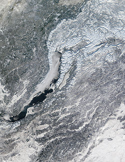
Climate
Climate encompasses the statistics of temperature, humidity, atmospheric pressure, wind, rainfall, atmospheric particle count and other meteorological elemental measurements in a given region over long periods...
because of its sheer size and compact configuration. Most of its land is more than 400 kilometres (249 mi) from the sea, and the center is 3840 kilometres (2,386 mi) from the sea. In addition, Russia's mountain ranges, predominantly to the south and the east, block moderating temperatures from the Indian
Indian Ocean
The Indian Ocean is the third largest of the world's oceanic divisions, covering approximately 20% of the water on the Earth's surface. It is bounded on the north by the Indian Subcontinent and Arabian Peninsula ; on the west by eastern Africa; on the east by Indochina, the Sunda Islands, and...
and Pacific Ocean
Pacific Ocean
The Pacific Ocean is the largest of the Earth's oceanic divisions. It extends from the Arctic in the north to the Southern Ocean in the south, bounded by Asia and Australia in the west, and the Americas in the east.At 165.2 million square kilometres in area, this largest division of the World...
s, but European Russia and northern Siberia lack such topographic protection from the Arctic
Arctic Ocean
The Arctic Ocean, located in the Northern Hemisphere and mostly in the Arctic north polar region, is the smallest and shallowest of the world's five major oceanic divisions...
and North Atlantic Ocean
Atlantic Ocean
The Atlantic Ocean is the second-largest of the world's oceanic divisions. With a total area of about , it covers approximately 20% of the Earth's surface and about 26% of its water surface area...
s.
Because only small parts of Russia are south of 50° north latitude
Latitude
In geography, the latitude of a location on the Earth is the angular distance of that location south or north of the Equator. The latitude is an angle, and is usually measured in degrees . The equator has a latitude of 0°, the North pole has a latitude of 90° north , and the South pole has a...
and more than half of the country is north of 60° north latitude, extensive regions experience six months of snow cover over subsoil
Subsoil
Subsoil, or substrata, is the layer of soil under the topsoil on the surface of the ground. The subsoil may include substances such as clay and/or sand that has only been partially broken down by air, sunlight, water, wind etc., to produce true soil...
that is permanently frozen
Permafrost
In geology, permafrost, cryotic soil or permafrost soil is soil at or below the freezing point of water for two or more years. Ice is not always present, as may be in the case of nonporous bedrock, but it frequently occurs and it may be in amounts exceeding the potential hydraulic saturation of...
to depths as far as several hundred meters. The average yearly temperature of nearly all of European Russia is below freezing, and the average for most of Siberia is freezing or below. Most of Russia has only two seasons, summer and winter, with very short intervals of moderation between them. Transportation routes, including entire railroad lines, are redirected in winter to traverse rock-solid waterways and lakes. Some areas constitute important exceptions to this description, however: the moderate maritime climate of Kaliningrad Oblast
Kaliningrad Oblast
Kaliningrad Oblast is a federal subject of Russia situated on the Baltic coast. It has a population of The oblast forms the westernmost part of the Russian Federation, but it has no land connection to the rest of Russia. Since its creation it has been an exclave of the Russian SFSR and then the...
on the Baltic Sea
Baltic Sea
The Baltic Sea is a brackish mediterranean sea located in Northern Europe, from 53°N to 66°N latitude and from 20°E to 26°E longitude. It is bounded by the Scandinavian Peninsula, the mainland of Europe, and the Danish islands. It drains into the Kattegat by way of the Øresund, the Great Belt and...
is similar to that of the American Northwest
Pacific Northwest
The Pacific Northwest is a region in northwestern North America, bounded by the Pacific Ocean to the west and, loosely, by the Rocky Mountains on the east. Definitions of the region vary and there is no commonly agreed upon boundary, even among Pacific Northwesterners. A common concept of the...
; the Russian Far East
Russian Far East
Russian Far East is a term that refers to the Russian part of the Far East, i.e., extreme east parts of Russia, between Lake Baikal in Eastern Siberia and the Pacific Ocean...
, under the influence of the Pacific Ocean, has a monsoon
Monsoon
Monsoon is traditionally defined as a seasonal reversing wind accompanied by corresponding changes in precipitation, but is now used to describe seasonal changes in atmospheric circulation and precipitation associated with the asymmetric heating of land and sea...
al climate that reverses the direction of wind in summer and winter, sharply differentiating temperatures; and a narrow, subtropical
Subtropics
The subtropics are the geographical and climatical zone of the Earth immediately north and south of the tropical zone, which is bounded by the Tropic of Cancer and the Tropic of Capricorn, at latitudes 23.5°N and 23.5°S...
band of territory provides Russia's most popular summer resort area on the Black Sea
Black Sea
The Black Sea is bounded by Europe, Anatolia and the Caucasus and is ultimately connected to the Atlantic Ocean via the Mediterranean and the Aegean seas and various straits. The Bosphorus strait connects it to the Sea of Marmara, and the strait of the Dardanelles connects that sea to the Aegean...
.
In winter, an intense high-pressure system causes winds to blow from the south and the southwest in all but the Pacific region of the Russian landmass; in summer, a low-pressure system brings winds from the north and the northwest to most of the landmass. Russia is the coldest country of the world (average annual temperature is −5.5 °C). That meteorological combination reduces the wintertime temperature difference between north and south. Thus, average January temperatures are −6 °C in Saint Petersburg, −27 °C in the West Siberian Plain
West Siberian Plain
The West Siberian Plain is a large plain that occupies the western portion of Siberia, between the Ural Mountains in the west and the Yenisei River in the east, and by the Altay Mountains on the South-East. Much of the plain is poorly drained and consists of some of the world's largest swamps and...
, and −43 °C at Yakutsk
Yakutsk
With a subarctic climate , Yakutsk is the coldest city, though not the coldest inhabited place, on Earth. Average monthly temperatures range from in July to in January. The coldest temperatures ever recorded on the planet outside Antarctica occurred in the basin of the Yana River to the northeast...
(in east-central Siberia, at approximately the same latitude as Saint Petersburg), while the winter average on the Mongolia
Mongolia
Mongolia is a landlocked country in East and Central Asia. It is bordered by Russia to the north and China to the south, east and west. Although Mongolia does not share a border with Kazakhstan, its western-most point is only from Kazakhstan's eastern tip. Ulan Bator, the capital and largest...
n border, whose latitude is some 10° farther south, is barely warmer. Summer temperatures are more affected by latitude, however; the Arctic islands average 4 °C (39.2 °F), and the southernmost regions average 20 °C (68 °F). Russia's potential for temperature extremes is typified by the national record low of −68 °C, recorded at Verkhoyansk
Verkhoyansk
Verkhoyansk is a town in Verkhoyansky District of the Sakha Republic, Russia, situated on the Yana River, near the Arctic Circle, from Yakutsk. Population: There is a river port, an airport, a fur-collecting depot, and the center of a reindeer-raising area....
in north-central Siberia and the record high of 43 °C (109.4 °F), recorded at several southern stations (Volgograd).
The long, cold winter has a profound impact on almost every aspect of life in Russia. It affects where and how long people live and work, what kinds of crops are grown, and where they are grown (no part of the country has a year-round growing season). The length and severity of the winter, together with the sharp fluctuations in the mean summer and winter temperatures, impose special requirements on many branches of the economy. In regions of permafrost, buildings must be constructed on pilings, machinery must be made of specially tempered steel, and transportation systems must be engineered to perform reliably in extremely low and extremely high temperatures. In addition, during extended periods of darkness and cold, there are increased demands for energy, health care, and textiles.
Because Russia has little exposure to ocean influences, most of the country receives low to moderate amounts of precipitation
Precipitation (meteorology)
In meteorology, precipitation In meteorology, precipitation In meteorology, precipitation (also known as one of the classes of hydrometeors, which are atmospheric water phenomena is any product of the condensation of atmospheric water vapor that falls under gravity. The main forms of precipitation...
. Highest precipitation falls in the northwest, with amounts decreasing from northwest to southeast across European Russia. The wettest areas are the small, lush subtropical region adjacent to the Caucasus and along the Pacific coast. Along the Baltic coast, average annual precipitation is 600 millimetres (23.6 in), and in Moscow it is 525 millimetres (20.7 in). An average of only 20 millimetre (0.78740157480315 in) falls along the Russian-Kazakh border, and as little as 15 millimetre (0.590551181102362 in) may fall along Siberia's Arctic coastline. Average annual days of snow cover, a critical factor for agriculture, depends on both latitude and altitude. Cover varies from forty to 200 days in European Russia, and from 120 to 250 days in Siberia.
Area and boundaries
Area:- Total: 17,075,200 km²
- Land: 16,995,800 km²
- Water: 79,400 km²
Area — comparative:
- AustraliaAustraliaAustralia , officially the Commonwealth of Australia, is a country in the Southern Hemisphere comprising the mainland of the Australian continent, the island of Tasmania, and numerous smaller islands in the Indian and Pacific Oceans. It is the world's sixth-largest country by total area...
comparative: slightly more than 2.2 times the size of Australia - CanadaCanadaCanada is a North American country consisting of ten provinces and three territories. Located in the northern part of the continent, it extends from the Atlantic Ocean in the east to the Pacific Ocean in the west, and northward into the Arctic Ocean...
comparative: slightly more than 1.7 times the size of Canada - United KingdomUnited KingdomThe United Kingdom of Great Britain and Northern IrelandIn the United Kingdom and Dependencies, other languages have been officially recognised as legitimate autochthonous languages under the European Charter for Regional or Minority Languages...
comparative: slightly more than 70 times the size of the UK - United StatesUnited StatesThe United States of America is a federal constitutional republic comprising fifty states and a federal district...
comparative: slightly more than 1.8 times the size of the U.S.
Land boundaries:
- Total: 19,917 km
Kaliningrad Oblast
Kaliningrad Oblast
Kaliningrad Oblast is a federal subject of Russia situated on the Baltic coast. It has a population of The oblast forms the westernmost part of the Russian Federation, but it has no land connection to the rest of Russia. Since its creation it has been an exclave of the Russian SFSR and then the...
is a small part of west Russia with no land connection to the rest of Russia.
Border countries:
- Russia excluding Kaliningrad Oblast—AzerbaijanAzerbaijanAzerbaijan , officially the Republic of Azerbaijan is the largest country in the Caucasus region of Eurasia. Located at the crossroads of Western Asia and Eastern Europe, it is bounded by the Caspian Sea to the east, Russia to the north, Georgia to the northwest, Armenia to the west, and Iran to...
; 284 km; BelarusBelarusBelarus , officially the Republic of Belarus, is a landlocked country in Eastern Europe, bordered clockwise by Russia to the northeast, Ukraine to the south, Poland to the west, and Lithuania and Latvia to the northwest. Its capital is Minsk; other major cities include Brest, Grodno , Gomel ,...
: 959 km; ChinaPeople's Republic of ChinaChina , officially the People's Republic of China , is the most populous country in the world, with over 1.3 billion citizens. Located in East Asia, the country covers approximately 9.6 million square kilometres...
: (southeast) 3,605 km, China (south): 40 km; EstoniaEstoniaEstonia , officially the Republic of Estonia , is a state in the Baltic region of Northern Europe. It is bordered to the north by the Gulf of Finland, to the west by the Baltic Sea, to the south by Latvia , and to the east by Lake Peipsi and the Russian Federation . Across the Baltic Sea lies...
: 294 km; FinlandFinlandFinland , officially the Republic of Finland, is a Nordic country situated in the Fennoscandian region of Northern Europe. It is bordered by Sweden in the west, Norway in the north and Russia in the east, while Estonia lies to its south across the Gulf of Finland.Around 5.4 million people reside...
: 1,313 km; GeorgiaGeorgia (country)Georgia is a sovereign state in the Caucasus region of Eurasia. Located at the crossroads of Western Asia and Eastern Europe, it is bounded to the west by the Black Sea, to the north by Russia, to the southwest by Turkey, to the south by Armenia, and to the southeast by Azerbaijan. The capital of...
: 723 km; KazakhstanKazakhstanKazakhstan , officially the Republic of Kazakhstan, is a transcontinental country in Central Asia and Eastern Europe. Ranked as the ninth largest country in the world, it is also the world's largest landlocked country; its territory of is greater than Western Europe...
: 6,846 km; LatviaLatviaLatvia , officially the Republic of Latvia , is a country in the Baltic region of Northern Europe. It is bordered to the north by Estonia , to the south by Lithuania , to the east by the Russian Federation , to the southeast by Belarus and shares maritime borders to the west with Sweden...
: 217 km; MongoliaMongoliaMongolia is a landlocked country in East and Central Asia. It is bordered by Russia to the north and China to the south, east and west. Although Mongolia does not share a border with Kazakhstan, its western-most point is only from Kazakhstan's eastern tip. Ulan Bator, the capital and largest...
: 3,441 km; North KoreaNorth KoreaThe Democratic People’s Republic of Korea , , is a country in East Asia, occupying the northern half of the Korean Peninsula. Its capital and largest city is Pyongyang. The Korean Demilitarized Zone serves as the buffer zone between North Korea and South Korea...
: 19 km; NorwayNorwayNorway , officially the Kingdom of Norway, is a Nordic unitary constitutional monarchy whose territory comprises the western portion of the Scandinavian Peninsula, Jan Mayen, and the Arctic archipelago of Svalbard and Bouvet Island. Norway has a total area of and a population of about 4.9 million...
: 167 km; UkraineUkraineUkraine is a country in Eastern Europe. It has an area of 603,628 km², making it the second largest contiguous country on the European continent, after Russia...
: 1,576 km - Kaliningrad Oblast—LithuaniaLithuaniaLithuania , officially the Republic of Lithuania is a country in Northern Europe, the biggest of the three Baltic states. It is situated along the southeastern shore of the Baltic Sea, whereby to the west lie Sweden and Denmark...
: 227 km; PolandPolandPoland , officially the Republic of Poland , is a country in Central Europe bordered by Germany to the west; the Czech Republic and Slovakia to the south; Ukraine, Belarus and Lithuania to the east; and the Baltic Sea and Kaliningrad Oblast, a Russian exclave, to the north...
: 206 km
Coastline: 37,653 km
Maritime claims:
- Russian continental shelf: 200 m depth or to the depth of exploitation
- Exclusive economic zone: 200 nmi (370.4 km; 230.2 mi)
- Territorial sea: 12 nmi (22.2 km; 13.8 mi)
Elevation extremes:
- Lowest point: Caspian SeaCaspian SeaThe Caspian Sea is the largest enclosed body of water on Earth by area, variously classed as the world's largest lake or a full-fledged sea. The sea has a surface area of and a volume of...
: −28 m - Highest point: Mount ElbrusMount ElbrusMount Elbrus is an inactive volcano located in the western Caucasus mountain range, in Kabardino-Balkaria and Karachay-Cherkessia, Russia, near the border of Georgia. Mt. Elbrus's peak is the highest in the Caucasus, in Russia...
: 5,642 m
Natural resources and land use
Russia holds the greatest reserves of mineral resources of any country in the world. Though they are abundant, they are in remote areas with extreme climates, making them expensive to mine. The country is the most abundant in mineral fuels. It may hold as much as half of the world's coalCoal
Coal is a combustible black or brownish-black sedimentary rock usually occurring in rock strata in layers or veins called coal beds or coal seams. The harder forms, such as anthracite coal, can be regarded as metamorphic rock because of later exposure to elevated temperature and pressure...
reserves and even larger reserves of petroleum
Petroleum
Petroleum or crude oil is a naturally occurring, flammable liquid consisting of a complex mixture of hydrocarbons of various molecular weights and other liquid organic compounds, that are found in geologic formations beneath the Earth's surface. Petroleum is recovered mostly through oil drilling...
. Deposits of coal are scattered throughout the region, but the largest are located in central and eastern Siberia
Siberia
Siberia is an extensive region constituting almost all of Northern Asia. Comprising the central and eastern portion of the Russian Federation, it was part of the Soviet Union from its beginning, as its predecessor states, the Tsardom of Russia and the Russian Empire, conquered it during the 16th...
. The most developed fields lie in western Siberia, in the northeastern European region, in the area around Moscow
Moscow
Moscow is the capital, the most populous city, and the most populous federal subject of Russia. The city is a major political, economic, cultural, scientific, religious, financial, educational, and transportation centre of Russia and the continent...
, and in the Urals
Ural Mountains
The Ural Mountains , or simply the Urals, are a mountain range that runs approximately from north to south through western Russia, from the coast of the Arctic Ocean to the Ural River and northwestern Kazakhstan. Their eastern side is usually considered the natural boundary between Europe and Asia...
. The major petroleum deposits are located in western Siberia and in the Volga-Urals. Smaller deposits are found throughout the country. Natural gas
Natural gas
Natural gas is a naturally occurring gas mixture consisting primarily of methane, typically with 0–20% higher hydrocarbons . It is found associated with other hydrocarbon fuel, in coal beds, as methane clathrates, and is an important fuel source and a major feedstock for fertilizers.Most natural...
, a resource of which Russia holds around forty percent of the world's reserves, can be found along Siberia's Arctic
Arctic
The Arctic is a region located at the northern-most part of the Earth. The Arctic consists of the Arctic Ocean and parts of Canada, Russia, Greenland, the United States, Norway, Sweden, Finland, and Iceland. The Arctic region consists of a vast, ice-covered ocean, surrounded by treeless permafrost...
coast, in the North Caucasus
North Caucasus
The North Caucasus is the northern part of the Caucasus region between the Black and Caspian Seas and within European Russia. The term is also used as a synonym for the North Caucasus economic region of Russia....
, and in northwestern Russia. Major iron-ore deposits are located south of Moscow, near the Ukrainian
Ukraine
Ukraine is a country in Eastern Europe. It has an area of 603,628 km², making it the second largest contiguous country on the European continent, after Russia...
border in the Kursk Magnetic Anomaly
Kursk Magnetic Anomaly
Kursk Magnetic Anomaly is a territory rich in iron ores located within the Kursk, Belgorod, and Voronezh oblasts in Russia, and constitutes a significant part of the Central Chernozyom Region...
; this area contains vast deposits of iron ore that have caused a deviation in the Earth's magnetic field. There are smaller deposits in other parts of the country. The Ural mountains hold small deposits of manganese
Manganese
Manganese is a chemical element, designated by the symbol Mn. It has the atomic number 25. It is found as a free element in nature , and in many minerals...
. Nickel
Nickel
Nickel is a chemical element with the chemical symbol Ni and atomic number 28. It is a silvery-white lustrous metal with a slight golden tinge. Nickel belongs to the transition metals and is hard and ductile...
, tungsten
Tungsten
Tungsten , also known as wolfram , is a chemical element with the chemical symbol W and atomic number 74.A hard, rare metal under standard conditions when uncombined, tungsten is found naturally on Earth only in chemical compounds. It was identified as a new element in 1781, and first isolated as...
, cobalt
Cobalt
Cobalt is a chemical element with symbol Co and atomic number 27. It is found naturally only in chemically combined form. The free element, produced by reductive smelting, is a hard, lustrous, silver-gray metal....
, molybdenum
Molybdenum
Molybdenum , is a Group 6 chemical element with the symbol Mo and atomic number 42. The name is from Neo-Latin Molybdaenum, from Ancient Greek , meaning lead, itself proposed as a loanword from Anatolian Luvian and Lydian languages, since its ores were confused with lead ores...
and other iron alloying elements occur in adequate quantities.
Russia also contains most of the nonferrous metals. Aluminium
Aluminium
Aluminium or aluminum is a silvery white member of the boron group of chemical elements. It has the symbol Al, and its atomic number is 13. It is not soluble in water under normal circumstances....
ores are scarce and are found primarily in the Ural region, northwestern European Russia, and south central Siberia. Copper
Copper
Copper is a chemical element with the symbol Cu and atomic number 29. It is a ductile metal with very high thermal and electrical conductivity. Pure copper is soft and malleable; an exposed surface has a reddish-orange tarnish...
is more abundant and major reserves are located in the Urals, the Norilsk
Norilsk
Norilsk is an industrial city in Krasnoyarsk Krai, Russia, located between the Yenisei River and the Taymyr Peninsula. Population: It was granted city status in 1953. It is the northernmost city in Siberia and the world's second largest city north of the Arctic Circle...
area near the mouth of the Yenisey
Yenisei River
Yenisei , also written as Yenisey, is the largest river system flowing to the Arctic Ocean. It is the central of the three great Siberian rivers that flow into the Arctic Ocean...
in eastern Siberia, and the Kola Peninsula
Kola Peninsula
The Kola Peninsula is a peninsula in the far northwest of Russia. Constituting the bulk of the territory of Murmansk Oblast, it lies almost completely to the north of the Arctic Circle and is washed by the Barents Sea in the north and the White Sea in the east and southeast...
. Another vast deposit located east of Lake Baikal
Lake Baikal
Lake Baikal is the world's oldest at 30 million years old and deepest lake with an average depth of 744.4 metres.Located in the south of the Russian region of Siberia, between Irkutsk Oblast to the northwest and the Buryat Republic to the southeast, it is the most voluminous freshwater lake in the...
only became exploited when the Baikal-Amur Mainline (BAM) railroad was finished in 1989.
The North Caucasus, far eastern Russia, and the western edge of the Kuznetsk Basin
Kuznetsk Basin
The Kuznetsk Basin in southwestern Siberia, Russia, is one of the largest coal mining areas in the world, covering an area of around . It lies in the Kuznetsk Depression between Tomsk and Novokuznetsk in the basin of the Tom River...
in southern Siberia contain an abundance of lead
Lead
Lead is a main-group element in the carbon group with the symbol Pb and atomic number 82. Lead is a soft, malleable poor metal. It is also counted as one of the heavy metals. Metallic lead has a bluish-white color after being freshly cut, but it soon tarnishes to a dull grayish color when exposed...
and zinc
Zinc
Zinc , or spelter , is a metallic chemical element; it has the symbol Zn and atomic number 30. It is the first element in group 12 of the periodic table. Zinc is, in some respects, chemically similar to magnesium, because its ion is of similar size and its only common oxidation state is +2...
ores. These are commonly found along with copper, gold
Gold
Gold is a chemical element with the symbol Au and an atomic number of 79. Gold is a dense, soft, shiny, malleable and ductile metal. Pure gold has a bright yellow color and luster traditionally considered attractive, which it maintains without oxidizing in air or water. Chemically, gold is a...
, silver
Silver
Silver is a metallic chemical element with the chemical symbol Ag and atomic number 47. A soft, white, lustrous transition metal, it has the highest electrical conductivity of any element and the highest thermal conductivity of any metal...
, and a large amount of other rare metals. The country has one of the largest gold reserves in the world; mostly in Siberia and the Urals. Mercury
Mercury (element)
Mercury is a chemical element with the symbol Hg and atomic number 80. It is also known as quicksilver or hydrargyrum...
deposits can be found in the central and southern Urals and in south central Siberia.
Raw materials are abundant as well, including potassium
Potassium
Potassium is the chemical element with the symbol K and atomic number 19. Elemental potassium is a soft silvery-white alkali metal that oxidizes rapidly in air and is very reactive with water, generating sufficient heat to ignite the hydrogen emitted in the reaction.Potassium and sodium are...
and magnesium
Magnesium
Magnesium is a chemical element with the symbol Mg, atomic number 12, and common oxidation number +2. It is an alkaline earth metal and the eighth most abundant element in the Earth's crust and ninth in the known universe as a whole...
salt
Salt
In chemistry, salts are ionic compounds that result from the neutralization reaction of an acid and a base. They are composed of cations and anions so that the product is electrically neutral...
deposits in the Kama River
Kama River
Kama is a major river in Russia, the longest left tributary of the Volga and the largest one in discharge; in fact, it is larger than the Volga before junction....
region of the western Urals. Russia also contains one of the world's largest deposits of apatite
Apatite
Apatite is a group of phosphate minerals, usually referring to hydroxylapatite, fluorapatite, chlorapatite and bromapatite, named for high concentrations of OH−, F−, Cl− or Br− ions, respectively, in the crystal...
found in the central Kola Peninsula. Rock salt is located in the southwestern Urals and the southwest of Lake Baikal. Surface deposits of salt are found in salt lakes along the lower Volga Valley. Sulfur
Sulfur
Sulfur or sulphur is the chemical element with atomic number 16. In the periodic table it is represented by the symbol S. It is an abundant, multivalent non-metal. Under normal conditions, sulfur atoms form cyclic octatomic molecules with chemical formula S8. Elemental sulfur is a bright yellow...
can be found in the Urals and the middle Volga Valley.
Eight percent of the land is used for arable farming
Agronomy
Agronomy is the science and technology of producing and using plants for food, fuel, feed, fiber, and reclamation. Agronomy encompasses work in the areas of plant genetics, plant physiology, meteorology, and soil science. Agronomy is the application of a combination of sciences like biology,...
, four percent—for permanent pasture
Pasture
Pasture is land used for grazing. Pasture lands in the narrow sense are enclosed tracts of farmland, grazed by domesticated livestock, such as horses, cattle, sheep or swine. The vegetation of tended pasture, forage, consists mainly of grasses, with an interspersion of legumes and other forbs...
s, forty-six percent of the land is forests and woodland, and forty-two percent is used for other purposes.
Natural hazards
Volcanic activity in the Kuril IslandsKuril Islands
The Kuril Islands , in Russia's Sakhalin Oblast region, form a volcanic archipelago that stretches approximately northeast from Hokkaidō, Japan, to Kamchatka, Russia, separating the Sea of Okhotsk from the North Pacific Ocean. There are 56 islands and many more minor rocks. It consists of Greater...
and volcanoes and earthquakes on the Kamchatka peninsula
Kamchatka Peninsula
The Kamchatka Peninsula is a peninsula in the Russian Far East, with an area of . It lies between the Pacific Ocean to the east and the Sea of Okhotsk to the west...
are other natural hazards.
Antipodes
The antipodesAntipodes
In geography, the antipodes of any place on Earth is the point on the Earth's surface which is diametrically opposite to it. Two points that are antipodal to one another are connected by a straight line running through the centre of the Earth....
of Russia lie in the South Pacific
Pacific Ocean
The Pacific Ocean is the largest of the Earth's oceanic divisions. It extends from the Arctic in the north to the Southern Ocean in the south, bounded by Asia and Australia in the west, and the Americas in the east.At 165.2 million square kilometres in area, this largest division of the World...
and South Atlantic near Antarctica. Only a small amount is antipodal to land. This includes the arctic islands of Franz Josef Land
Franz Josef Land
Franz Josef Land, Franz Joseph Land, or Francis Joseph's Land is an archipelago located in the far north of Russia. It is found in the Arctic Ocean north of Novaya Zemlya and east of Svalbard, and is administered by Arkhangelsk Oblast. Franz Josef Land consists of 191 ice-covered islands with a...
, Victoria
Victoria Island (Russian Arctic)
Victoria Island is a small Arctic island situated at 80°9'N 36°46'E, halfway between the Norwegian archipelago of Svalbard and the Russian archipelago of Franz Josef Land. This westernmost of all Russian Arctic islands is about 14 km² and almost completely covered with ice...
, and North Novaya Zemlya
Severny Island
Severny Island is the northern island of the Novaya Zemlya archipelago, lying north of Russia. It has an area of , making it one of the largest islands in the world. It is separated from Yuzhny Island by the narrow Matochkin Strait...
(to Marie Byrd Land
Marie Byrd Land
Marie Byrd Land is the portion of West Antarctica lying east of the Ross Ice Shelf and the Ross Sea and south of the Pacific Ocean, extending eastward approximately to a line between the head of the Ross Ice Shelf and Eights Coast. It stretches between 158°W and 103°24'W...
in Antarctica); Severnaya Zemlya
Severnaya Zemlya
Severnaya Zemlya is an archipelago in the Russian high Arctic at around . It is located off mainland Siberia's Taymyr Peninsula across the Vilkitsky Strait...
(to the Ronne Ice Shelf and the Ellsworth Mountains
Ellsworth Mountains
The Ellsworth Mountains are the highest mountain ranges in Antarctica, forming a long and wide chain of mountains in a north to south configuration on the western margin of the Ronne Ice Shelf. They are bisected by Minnesota Glacier to form the northern Sentinel Range and the southern Heritage...
behind it); the De Long Islands
De Long Islands
The De Long Islands are an uninhabited archipelago often included as part of the New Siberian Islands, lying north east of Novaya Sibir. This archipelago consists of Jeannette Island, Henrietta Island, Bennett Island, Vilkitsky Island and Zhokhov Island. These five islands have a total area of...
(to Coats Land
Coats Land
Coats Land is a region in Antarctica which lies westward of Queen Maud Land and forms the eastern shore of the Weddell Sea, extending in a general northeast-southwest direction between 20º00´W and 36º00´W. The northeast part was discovered from the Scotia by William S. Bruce, leader of the Scottish...
, or just off shore); and Wrangel Island
Wrangel Island
Wrangel Island is an island in the Arctic Ocean, between the Chukchi Sea and East Siberian Sea. Wrangel Island lies astride the 180° meridian. The International Date Line is displaced eastwards at this latitude to avoid the island as well as the Chukchi Peninsula on the Russian mainland...
(to Queen Maud Land
Queen Maud Land
Queen Maud Land is a c. 2.7 million-square-kilometre region of Antarctica claimed as a dependent territory by Norway. The territory lies between 20° west and 45° east, between the British Antarctic Territory to the west and the Australian Antarctic Territory to the east. The latitudinal...
and its offshore Fimbul Ice Shelf
Fimbul Ice Shelf
Fimbul Ice Shelf is an ice shelf about 120 miles long and 60 miles wide, nourished by Jutulstraumen Glacier, bordering the coast of Queen Maud Land from 3° W to 3° E...
).
In addition, northern Ellsworth Land
Ellsworth Land
Ellsworth Land is that portion of the Antarctic continent bounded on the west by Marie Byrd Land, on the north by Bellingshausen Sea, on the northeast by the base of Antarctic Peninsula, and on the east by the western margin of Ronne Ice Shelf. It extends between 103°24'W and 79°45'W...
and the base of the Antarctic Peninsula
Antarctic Peninsula
The Antarctic Peninsula is the northernmost part of the mainland of Antarctica. It extends from a line between Cape Adams and a point on the mainland south of Eklund Islands....
are largely antipodal to the Taymyr Peninsula
Taymyr Peninsula
The Taymyr Peninsula is a peninsula in the Far North of Russia, in the Siberian Federal District, that forms the northernmost part of mainland Eurasia and Asia...
, while Alexander Island
Alexander Island
Alexander Island or Alexander I Island or Alexander I Land or Alexander Land is the largest island of Antarctica, with an area of lying in the Bellingshausen Sea west of the base of the Antarctic Peninsula, from which it is separated by Marguerite Bay and George VI Sound. Alexander Island lies off...
is antipodal to eastern Taymyria
Taymyrsky Dolgano-Nenetsky District
Taymyrsky Dolgano-Nenetsky District is an administrative and municipal district , one of the forty-three in Krasnoyarsk Krai, Russia. It is located in the northern portion of the krai above the Arctic Circle on Taymyr Peninsula and borders with Laptev and Kara Seas in the north, the Sakha Republic...
south of the Khatanga Gulf
Khatanga Gulf
The Khatanga Gulf or Khatanga Bay is a large tidal estuary in the Laptev Sea. It is relatively narrow, its length being 220 km with a maximum width of 54 km....
. The free part of the Antarctic Peninsula is antipodal to the western Sakha Republic, from its northwestern coast southward, running east of the Lena River
Lena River
The Lena is the easternmost of the three great Siberian rivers that flow into the Arctic Ocean . It is the 11th longest river in the world and has the 9th largest watershed...
, with the northern end of the peninsula covering the towns of Vilyuysk
Vilyuysk
Vilyuysk is a town and the administrative center of Vilyuysky District of the Sakha Republic, Russia, located about from Yakutsk on the Vilyuy River...
and Kysyl-Syr and stopping about 300 km short of Yakutsk
Yakutsk
With a subarctic climate , Yakutsk is the coldest city, though not the coldest inhabited place, on Earth. Average monthly temperatures range from in July to in January. The coldest temperatures ever recorded on the planet outside Antarctica occurred in the basin of the Yana River to the northeast...
.
The antipodes of the South Orkney Islands
South Orkney Islands
The South Orkney Islands are a group of islands in the Southern Ocean, about north-east of the tip of the Antarctic Peninsula. They have a total area of about ....
are on the Aldan River
Aldan River
The Aldan River is the second-longest tributary of the Lena River in the Sakha Republic in eastern Siberia. The river is 2,273 km long, of which around 1,600 km is navigable. It was part of the River Route to Okhotsk...
on the other side of Yakutsk, between Ust-Maya
Ust-Maya
Ust-Maya is an urban locality and the administrative center of Ust-Maysky District of the Sakha Republic, Russia, located at the confluence of the Maya and Aldan Rivers, southeast of Yakutsk. Population:...
and Eldikan
Eldikan
Eldikan is an urban locality in Ust-Maysky District of the Sakha Republic, Russia, located on the right bank of the Aldan River, northeast of Ust-Maya, the administrative center of the district. Population:...
, in southwestern Sakha. The southern two South Sandwich Islands are antipodal to the Pyagin Peninsula east of Magadan
Magadan
Magadan is a port town on the Sea of Okhotsk and gateway to the Kolyma region. It is the administrative center of Magadan Oblast , in the Russian Far East. Founded in 1929 on the site of an earlier settlement from the 1920s, it was granted the status of town in 1939...
. Western South Georgia Island is antipodal to the northern tip of Sakhalin
Sakhalin
Sakhalin or Saghalien, is a large island in the North Pacific, lying between 45°50' and 54°24' N.It is part of Russia, and is Russia's largest island, and is administered as part of Sakhalin Oblast...
.
Peter I Island
Peter I Island
Peter I Island is an uninhabited volcanic island in the Bellingshausen Sea, from Antarctica. It is claimed as a dependency of Norway, and along with Queen Maud Land and Bouvet Island comprises one of the three Norwegian dependent territories in the Antarctic and sub-Antarctic. Peter I Island is ...
, claimed by Norway on the other side of the Peninsula, is opposite a spot 70 km SE of Norilsk
Norilsk
Norilsk is an industrial city in Krasnoyarsk Krai, Russia, located between the Yenisei River and the Taymyr Peninsula. Population: It was granted city status in 1953. It is the northernmost city in Siberia and the world's second largest city north of the Arctic Circle...
.
The only inhabited lands antipodal to Russia are southern Patagonia
Patagonia
Patagonia is a region located in Argentina and Chile, integrating the southernmost section of the Andes mountains to the southwest towards the Pacific ocean and from the east of the cordillera to the valleys it follows south through Colorado River towards Carmen de Patagones in the Atlantic Ocean...
, including Tierra del Fuego
Tierra del Fuego
Tierra del Fuego is an archipelago off the southernmost tip of the South American mainland, across the Strait of Magellan. The archipelago consists of a main island Isla Grande de Tierra del Fuego divided between Chile and Argentina with an area of , and a group of smaller islands including Cape...
, which correspond to much of Buryatia
Buryatia
The Republic of Buryatia is a federal subject of Russia . Its capital is the city of Ulan-Ude. Its area is with a population of 972,658 .-Geography:...
, the western shore of Lake Baikal
Lake Baikal
Lake Baikal is the world's oldest at 30 million years old and deepest lake with an average depth of 744.4 metres.Located in the south of the Russian region of Siberia, between Irkutsk Oblast to the northwest and the Buryat Republic to the southeast, it is the most voluminous freshwater lake in the...
in Irkutsk Oblast
Irkutsk Oblast
Irkutsk Oblast is a federal subject of Russia , located in southeastern Siberia in the basins of Angara River, Lena, and Nizhnyaya Tunguska Rivers. The administrative center is the city of Irkutsk. Population: -History:...
, and southwestern Zabaykalsky Krai, down to the Mongolian border, with Ulan-Ude
Ulan-Ude
Ulan-Ude is the capital city of the Republic of Buryatia, Russia, located about southeast of Lake Baikal on the Uda River at its confluence with the Selenga...
being antipodal to Puerto Natales, Chile. The sparsely inhabited West Falkland
West Falkland
West Falkland is the second largest of the Falkland Islands in the South Atlantic. It is a hilly island, separated from East Falkland by Falkland Sound. Its area is and its coastline is long. Including the adjacent small islands the land area is .-Population:The island has fewer than 200...
and neighboring islets are antipodal to eastern Zabaykalsky on the border with northern Inner Mongolia
Inner Mongolia
Inner Mongolia is an autonomous region of the People's Republic of China, located in the northern region of the country. Inner Mongolia shares an international border with the countries of Mongolia and the Russian Federation...
.