

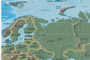
Novaya Zemlya
Encyclopedia

Dutch language
Dutch is a West Germanic language and the native language of the majority of the population of the Netherlands, Belgium, and Suriname, the three member states of the Dutch Language Union. Most speakers live in the European Union, where it is a first language for about 23 million and a second...
as Nova Zembla and in Norwegian
Norwegian language
Norwegian is a North Germanic language spoken primarily in Norway, where it is the official language. Together with Swedish and Danish, Norwegian forms a continuum of more or less mutually intelligible local and regional variants .These Scandinavian languages together with the Faroese language...
as (lit. the Goose Land), is an archipelago
Archipelago
An archipelago , sometimes called an island group, is a chain or cluster of islands. The word archipelago is derived from the Greek ἄρχι- – arkhi- and πέλαγος – pélagos through the Italian arcipelago...
in the Arctic Ocean
Arctic Ocean
The Arctic Ocean, located in the Northern Hemisphere and mostly in the Arctic north polar region, is the smallest and shallowest of the world's five major oceanic divisions...
in the north of Russia
Russia
Russia or , officially known as both Russia and the Russian Federation , is a country in northern Eurasia. It is a federal semi-presidential republic, comprising 83 federal subjects...
and the extreme northeast of Europe
Europe
Europe is, by convention, one of the world's seven continents. Comprising the westernmost peninsula of Eurasia, Europe is generally 'divided' from Asia to its east by the watershed divides of the Ural and Caucasus Mountains, the Ural River, the Caspian and Black Seas, and the waterways connecting...
, the easternmost point of Europe
Extreme points of Europe
This is a list of the extreme points of Europe: the geographical points that are higher, farther north, south, east or west than any other location in Europe. Some of these positions are open to debate, as the definition of Europe is diverse....
lying at Cape Flissingsky on the northern island. Administratively, it is incorporated as Novaya Zemlya District, one of the twenty-one
Administrative divisions of Arkhangelsk Oblast
Administratively, Arkhangelsk Oblast is divided into six cities and towns of oblast significance, twenty-one districts, and two island territories . Besides, Mirny is a town under the federal government management....
in Arkhangelsk Oblast
Arkhangelsk Oblast
Arkhangelsk Oblast is a federal subject of Russia . It includes the Arctic archipelagos of Franz Josef Land and Novaya Zemlya, as well as the Solovetsky Islands in the White Sea....
, Russia
Russia
Russia or , officially known as both Russia and the Russian Federation , is a country in northern Eurasia. It is a federal semi-presidential republic, comprising 83 federal subjects...
. Municipally, it is incorporated as Novaya Zemlya Urban Okrug. Its population is of which 1,972 reside in Belushya Guba
Belushya Guba
Belushya Guba is an urban locality and the administrative center of Novaya Zemlya District of Arkhangelsk Oblast, Russia, located in the southwestern portion of the Southern Island of the Novaya Zemlya arctic archipelago. Population:...
, an urban-type settlement
Urban-type settlement
Urban-type settlement ; , selyshche mis'koho typu ) is an official designation for a type of locality used in some of the countries of the former Soviet Union...
that is the administrative center of Novaya Zemlya District. The population in 2002 was
The indigenous population (from 1872 to the 1950s when it was resettled to the mainland) consisted of about 50–300 Nenetses
Nenets people
The Nenets are an indigenous people in Russia. According to the latest census in 2002, there are 41,302 Nenets in the Russian Federation, most of them living in the Yamalo-Nenets Autonomous Okrug and Nenets Autonomous Okrug...
who subsisted mainly on fishing
Fishing
Fishing is the activity of trying to catch wild fish. Fish are normally caught in the wild. Techniques for catching fish include hand gathering, spearing, netting, angling and trapping....
, trapping, reindeer
Reindeer
The reindeer , also known as the caribou in North America, is a deer from the Arctic and Subarctic, including both resident and migratory populations. While overall widespread and numerous, some of its subspecies are rare and one has already gone extinct.Reindeer vary considerably in color and size...
herding, polar bear
Polar Bear
The polar bear is a bear native largely within the Arctic Circle encompassing the Arctic Ocean, its surrounding seas and surrounding land masses. It is the world's largest land carnivore and also the largest bear, together with the omnivorous Kodiak Bear, which is approximately the same size...
hunting and seal hunting.
Novaya Zemlya consists of two major islands, separated by the narrow Matochkin Strait
Matochkin Strait
Matochkin Strait or Matochkin Shar is a strait between the Severny and Yuzhny Islands of Novaya Zemlya. It connects the Barents Sea and the Kara Sea. The banks along the strait are high and steep. Its length is approximately and its width in its narrowest part is approximately . The strait is...
, and a number of smaller islands. The two main islands are Severny
Severny Island
Severny Island is the northern island of the Novaya Zemlya archipelago, lying north of Russia. It has an area of , making it one of the largest islands in the world. It is separated from Yuzhny Island by the narrow Matochkin Strait...
(northern) and Yuzhny
Yuzhny Island
Yuzhny is the southern island of the Novaya Zemlya archipelago, lying north of Russia. It has an area of , which while smaller than the northern island of Severny, makes it one of the largest islands in the world.-Ecology:...
(southern). Novaya Zemlya separates the Barents Sea
Barents Sea
The Barents Sea is a marginal sea of the Arctic Ocean, located north of Norway and Russia. Known in the Middle Ages as the Murman Sea, the sea takes its current name from the Dutch navigator Willem Barents...
from the Kara Sea
Kara Sea
The Kara Sea is part of the Arctic Ocean north of Siberia. It is separated from the Barents Sea to the west by the Kara Strait and Novaya Zemlya, and the Laptev Sea to the east by the Severnaya Zemlya....
. The total area is about 90650 square kilometres (35,000.2 sq mi).
As Novaya Zemlya was a sensitive military area during the Cold War
Cold War
The Cold War was the continuing state from roughly 1946 to 1991 of political conflict, military tension, proxy wars, and economic competition between the Communist World—primarily the Soviet Union and its satellite states and allies—and the powers of the Western world, primarily the United States...
years, the Soviet Air Force maintained a presence at Rogachevo
Rogachevo
Rogachevo is a military air base on Novaya Zemlya, Russia located 9 km northeast of Belushya Guba. It was originally used as a staging base for intercontinental Long Range Aviation bomber flights...
air base on the southern part of the island. It was used primarily for interceptor aircraft
Interceptor aircraft
An interceptor aircraft is a type of fighter aircraft designed specifically to prevent missions of enemy aircraft, particularly bombers and reconnaissance aircraft. Interceptors generally rely on high speed and powerful armament in order to complete their mission as quickly as possible and set up...
operations but also provided logistical support for the nearby nuclear test area. It was the site of the October 30, 1961 explosion of Tsar Bomba
Tsar Bomba
Tsar Bomba is the nickname for the AN602 hydrogen bomb, the most powerful nuclear weapon ever detonated. It was also referred to as Kuz'kina Mat , in this usage meaning "something that has not been seen before"....
, the largest, most powerful nuclear weapon ever detonated.
Environment
Novaya Zemlya is the northern part of the Ural MountainsUral Mountains
The Ural Mountains , or simply the Urals, are a mountain range that runs approximately from north to south through western Russia, from the coast of the Arctic Ocean to the Ural River and northwestern Kazakhstan. Their eastern side is usually considered the natural boundary between Europe and Asia...
, and the interior is mountainous throughout. It is separated from the mainland by the Kara Strait
Kara Strait
The Kara Strait or Kara Gates is a 56 km wide channel of water between the southern end of Novaya Zemlya and the northern tip of Vaygach Island...
. The mountains reach a height of 1547 metres (5,075.5 ft). The northern island contains many glacier
Glacier
A glacier is a large persistent body of ice that forms where the accumulation of snow exceeds its ablation over many years, often centuries. At least 0.1 km² in area and 50 m thick, but often much larger, a glacier slowly deforms and flows due to stresses induced by its weight...
s, while the southern one has a tundra
Tundra
In physical geography, tundra is a biome where the tree growth is hindered by low temperatures and short growing seasons. The term tundra comes through Russian тундра from the Kildin Sami word tūndâr "uplands," "treeless mountain tract." There are three types of tundra: Arctic tundra, alpine...
landscape. Natural resources include copper
Copper
Copper is a chemical element with the symbol Cu and atomic number 29. It is a ductile metal with very high thermal and electrical conductivity. Pure copper is soft and malleable; an exposed surface has a reddish-orange tarnish...
, lead
Lead
Lead is a main-group element in the carbon group with the symbol Pb and atomic number 82. Lead is a soft, malleable poor metal. It is also counted as one of the heavy metals. Metallic lead has a bluish-white color after being freshly cut, but it soon tarnishes to a dull grayish color when exposed...
, and zinc
Zinc
Zinc , or spelter , is a metallic chemical element; it has the symbol Zn and atomic number 30. It is the first element in group 12 of the periodic table. Zinc is, in some respects, chemically similar to magnesium, because its ion is of similar size and its only common oxidation state is +2...
.
The ecology
Ecology
Ecology is the scientific study of the relations that living organisms have with respect to each other and their natural environment. Variables of interest to ecologists include the composition, distribution, amount , number, and changing states of organisms within and among ecosystems...
of Novaya Zemlya is influenced by its severe climate, but the region nevertheless supports a diversity of biota
Biota (ecology)
Biota are the total collection of organisms of a geographic region or a time period, from local geographic scales and instantaneous temporal scales all the way up to whole-planet and whole-timescale spatiotemporal scales. The biota of the Earth lives in the biosphere.-See...
. One of the most notable species present is the polar bear
Polar Bear
The polar bear is a bear native largely within the Arctic Circle encompassing the Arctic Ocean, its surrounding seas and surrounding land masses. It is the world's largest land carnivore and also the largest bear, together with the omnivorous Kodiak Bear, which is approximately the same size...
, whose population in the Barents Sea
Barents Sea
The Barents Sea is a marginal sea of the Arctic Ocean, located north of Norway and Russia. Known in the Middle Ages as the Murman Sea, the sea takes its current name from the Dutch navigator Willem Barents...
region is genetically distinct from other polar bear subpopulation
Statistical population
A statistical population is a set of entities concerning which statistical inferences are to be drawn, often based on a random sample taken from the population. For example, if we were interested in generalizations about crows, then we would describe the set of crows that is of interest...
s.
History
The Russians knew of Novaya Zemlya from the 11th century, when hunters from Novgorod visited the area. For western Europeans, the search for the Northeast passageNorthern Sea Route
The Northern Sea Route is a shipping lane officially defined by Russian legislation from the Atlantic Ocean to the Pacific Ocean specifically running along the Russian Arctic coast from Murmansk on the Barents Sea, along Siberia, to the Bering Strait and Far East. The entire route lies in Arctic...
in the 16th century led to its exploration. The first visit from a west European was by Hugh Willoughby
Hugh Willoughby (sea captain)
Sir Hugh Willoughby of Risley, Derbyshire was an early English Arctic voyager. He was sent out on 10 May 1553, as captain of the Bona Esperanza with two other vessels under his command and with chief pilot Richard Chancellor, by a company of London merchants known as the Company of Merchant...
in 1553, and he met Russian ships from the already established hunting trade. Dutch explorer Willem Barents
Willem Barents
Willem Barentsz was a Dutch navigator, cartographer, explorer, and a leader of early expeditions to the far north....
reached the west coast of Novaya Zemlya in 1594, and in a subsequent expedition of 1596 rounded the northern point and wintered on the north-east coast. (Barents perished during the expedition, and may have been buried on the northern island.) During a later voyage by Fyodor Litke in 1821–1824, the west coast was mapped
Cartography
Cartography is the study and practice of making maps. Combining science, aesthetics, and technique, cartography builds on the premise that reality can be modeled in ways that communicate spatial information effectively.The fundamental problems of traditional cartography are to:*Set the map's...
. Henry Hudson
Henry Hudson
Henry Hudson was an English sea explorer and navigator in the early 17th century. Hudson made two attempts on behalf of English merchants to find a prospective Northeast Passage to Cathay via a route above the Arctic Circle...
was another explorer who passed through Novaya Zemlya while searching for the Northeast Passage.
The island was systematically surveyed by Pyotr Pakhtusov
Pyotr Pakhtusov
Pyotr Kuzmich Pakhtusov was a Russian surveyor and Arctic explorer. He is credited with the first thorough survey of Novaya Zemlya....
and Avgust Tsivolko
Avgust Tsivolko
Avgust Karlovich Tsivolko, also spelled as Tsivolka was a Russian navigator and Arctic explorer....
in the early 1830s. The first permanent settlement was established in 1870 at Malye Karmakuly, which served as capital of Novaya Zemlya until 1924. Later the administrative center was transferred to Belushya Guba
Belushya Guba
Belushya Guba is an urban locality and the administrative center of Novaya Zemlya District of Arkhangelsk Oblast, Russia, located in the southwestern portion of the Southern Island of the Novaya Zemlya arctic archipelago. Population:...
, in 1935 to Lagernoe, but then turned back to Belushya Guba
Belushya Guba
Belushya Guba is an urban locality and the administrative center of Novaya Zemlya District of Arkhangelsk Oblast, Russia, located in the southwestern portion of the Southern Island of the Novaya Zemlya arctic archipelago. Population:...
.
Small numbers of Nenets
Nenets people
The Nenets are an indigenous people in Russia. According to the latest census in 2002, there are 41,302 Nenets in the Russian Federation, most of them living in the Yamalo-Nenets Autonomous Okrug and Nenets Autonomous Okrug...
were resettled to Novaya Zemlya in the 1870s in a bid by Russia to keep out the Norwegians. This population, then numbering 298, was removed to the mainland in 1957 before nuclear testing began.
In 1943, during World War II
World War II
World War II, or the Second World War , was a global conflict lasting from 1939 to 1945, involving most of the world's nations—including all of the great powers—eventually forming two opposing military alliances: the Allies and the Axis...
, Novaya Zemlya briefly served as a secret seaplane base for the German Navy
Kriegsmarine
The Kriegsmarine was the name of the German Navy during the Nazi regime . It superseded the Kaiserliche Marine of World War I and the post-war Reichsmarine. The Kriegsmarine was one of three official branches of the Wehrmacht, the unified armed forces of Nazi Germany.The Kriegsmarine grew rapidly...
, to provide German surveillance of Allied ships en route to Siberia
Siberia
Siberia is an extensive region constituting almost all of Northern Asia. Comprising the central and eastern portion of the Russian Federation, it was part of the Soviet Union from its beginning, as its predecessor states, the Tsardom of Russia and the Russian Empire, conquered it during the 16th...
. The seaplane base was established by U-255, which was operating along the northern coast of Russia
Russia
Russia or , officially known as both Russia and the Russian Federation , is a country in northern Eurasia. It is a federal semi-presidential republic, comprising 83 federal subjects...
as part of 13th U-boat Flotilla.
Nuclear testing
In July 1954, Novaya Zemlya was designated the Novaya Zemlya Test Site, construction of which began in October and existed during much of the Cold WarCold War
The Cold War was the continuing state from roughly 1946 to 1991 of political conflict, military tension, proxy wars, and economic competition between the Communist World—primarily the Soviet Union and its satellite states and allies—and the powers of the Western world, primarily the United States...
. "Zone A", Chyornaya Guba (70.7°N 54.6°E), was used in 1955–1962 and 1972–1975. "Zone B", Matochkin Shar (73.4°N 54.9°E), was used for underground tests in 1964–1990. "Zone C", Sukhoy Nos
Sukhoy Nos
Sukhoy Nos is a cape on Severny, the northern island of the archipelago Novaya Zemlya, belonging to the Russian Federation. The site lies near the southern end of the island, very close to the Matochkin Strait, which separates Severny from Yuzhny, the southern island...
(73.7°N 54.0°E), was used in 1958–1961 and was the 1961 explosion site of the 100 megaton (fired device was a downgraded design to 50)Tsar Bomba
Tsar Bomba
Tsar Bomba is the nickname for the AN602 hydrogen bomb, the most powerful nuclear weapon ever detonated. It was also referred to as Kuz'kina Mat , in this usage meaning "something that has not been seen before"....
, the biggest nuclear bomb ever detonated.
Other tests occurred elsewhere throughout the islands, with an official testing range covering over half of the landmass. In September 1961 two propelled thermonuclear warheads were launched from Vorkuta Sovetsky
Vorkuta Sovetsky
Vorkuta Sovetskiy is a military airfield in the Komi Republic, Russia located 11 km east of Vorkuta. It contains one of the largest runways in Russia's Arctic region...
and Salekhard
Salekhard
-International relations:-Twin towns/sister cities:Salekhard is twinned with:*Azov, Rostov Oblast, Russia-External links:*...
respectively to target areas on Novaya Zemlya. The launch rocket was subsequently deployed to Cuba
Cuban Missile Crisis
The Cuban Missile Crisis was a confrontation among the Soviet Union, Cuba and the United States in October 1962, during the Cold War...
.
1963 saw the implementation of the Limited Test Ban Treaty outlawing most atmospheric nuclear tests. The largest underground test at Novaya Zemlya took place on September 12, 1973, involving four nuclear devices of 4.2 megatons total yield. Although far smaller in blast power than the Tsar Bomba
Tsar Bomba
Tsar Bomba is the nickname for the AN602 hydrogen bomb, the most powerful nuclear weapon ever detonated. It was also referred to as Kuz'kina Mat , in this usage meaning "something that has not been seen before"....
and other atmospheric tests, the confinement of the blasts underground led to pressures rivaling natural earthquake
Earthquake
An earthquake is the result of a sudden release of energy in the Earth's crust that creates seismic waves. The seismicity, seismism or seismic activity of an area refers to the frequency, type and size of earthquakes experienced over a period of time...
s. In the case of the September 12, 1973, test, a seismic magnitude of 6.97 on the Richter Scale was reached, setting off an 80 million ton avalanche
Avalanche
An avalanche is a sudden rapid flow of snow down a slope, occurring when either natural triggers or human activity causes a critical escalating transition from the slow equilibrium evolution of the snow pack. Typically occurring in mountainous terrain, an avalanche can mix air and water with the...
that blocked two glacial streams and created a lake 2 kilometres (1.2 mi) in length.
Over its history as a nuclear test site, Novaya Zemlya hosted 224 nuclear detonations with a total explosive energy equivalent to 265 megatons of TNT. For comparison, all explosives used in World War II
World War II
World War II, or the Second World War , was a global conflict lasting from 1939 to 1945, involving most of the world's nations—including all of the great powers—eventually forming two opposing military alliances: the Allies and the Axis...
, including the detonations of two U.S. nuclear bombs, amounted to only two megatons.
In 1988–1989, glasnost
Glasnost
Glasnost was the policy of maximal publicity, openness, and transparency in the activities of all government institutions in the Soviet Union, together with freedom of information, introduced by Mikhail Gorbachev in the second half of the 1980s...
helped make the Novaya Zemlya testing activities public knowledge, and in 1990 Greenpeace
Greenpeace
Greenpeace is a non-governmental environmental organization with offices in over forty countries and with an international coordinating body in Amsterdam, The Netherlands...
activists staged a protest at the site. The last nuclear test explosion was in 1990 (also the last for the entire Soviet Union and Russia). The Ministry for Atomic Energy has performed a series of subcritical underwater nuclear experiments near Matochkin Shar each autumn since 1998. These tests reportedly involve up to 100 grams (3.5 oz) of weapons-grade plutonium.
See also
- Extreme points of EuropeExtreme points of EuropeThis is a list of the extreme points of Europe: the geographical points that are higher, farther north, south, east or west than any other location in Europe. Some of these positions are open to debate, as the definition of Europe is diverse....
- List of islands of Russia
- Novaya Zemlya effectNovaya Zemlya effectThe Novaya Zemlya effect is a polar mirage caused by high refraction of sunlight between atmospheric thermoclines. The Novaya Zemlya effect will give the impression that the sun is rising earlier than it actually should and depending on the meteorological situation the effect will present the sun...
- Gusinaya ZemlyaGusinaya ZemlyaThe Gusinaya Zemlya is peninsula located in Arkhangelsk Oblast, Russia. It is the biggest peninsula on the archipelago Novaya Zemlya. It protrudes into the Barents Sea, with Kostin Shar to the south, and Mollera Bay to the north.- Sources :* *...
- Nova Zembla (2011 film)Nova Zembla (film)Nova Zembla is a 2011 Dutch historical drama film directed by Reinout Oerlemans. It is the first Dutch feature film in 3D.The film describes the last journey of Willem Barentsz and Jacob van Heemskerck through 1596-1597 when they and their crew tried to discover the North East passage to the Indies...
- Nova ZemblaNova ZemblaNova Zembla may refer to:* Nova Zembla Island, Nunavut, Canada* Nova Zembla , a 2011 Dutch film* Nova Zembla , a Belgian electronic music label-See also:...
External links
- Selected satellite views of nuclear test site Novaya Zemlya (global security).
- Environment, climate change, and history of exploration (Barents' wintering).
- Rozenberg Publishers - Climate and glacial history of the Novaya Zemlya Archipelago, Russian Arctic
- Nuclear tests in Novaya Zemlya, International Atomic Energy Agency Department of Nuclear Safety and Security.
- List of islands (Russian language)