
East European Plain
Encyclopedia
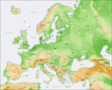
The East European Plain (also known as Russian Plain) is a plain
comprising a series of river basins
in Eastern Europe
. Together with the Northern European Plain it constitutes the European Plain
. It is the largest mountain-free part of the European landscape
.
The plain spans approximately 4000000 square kilometres (1,544,408.6 sq mi) and averages about 170 metres (557.7 ft) in elevation. The highest point of the plain, located in the Valdai Hills
is 346.9 metres (1,138.1 ft).
and the Barents Sea
in the North, Ural Mountains, Ural River
and Caspian Sea
in the East, Caucasus Mountains
and the Black Sea
in the South, Carpathian Mountains
and other mountainous features in Poland
in the West.
features are within the East European Plain (listed generally from North to South).
Plain
In geography, a plain is land with relatively low relief, that is flat or gently rolling. Prairies and steppes are types of plains, and the archetype for a plain is often thought of as a grassland, but plains in their natural state may also be covered in shrublands, woodland and forest, or...
comprising a series of river basins
Drainage basin
A drainage basin is an extent or an area of land where surface water from rain and melting snow or ice converges to a single point, usually the exit of the basin, where the waters join another waterbody, such as a river, lake, reservoir, estuary, wetland, sea, or ocean...
in Eastern Europe
Eastern Europe
Eastern Europe is the eastern part of Europe. The term has widely disparate geopolitical, geographical, cultural and socioeconomic readings, which makes it highly context-dependent and even volatile, and there are "almost as many definitions of Eastern Europe as there are scholars of the region"...
. Together with the Northern European Plain it constitutes the European Plain
European Plain
The European Plain or Great European Plain is a plain in Europe. It is the largest mountain-free landform in Europe, although a number of highlands are identified within. It stretches from the Pyrenees Mountains and the Atlantic Ocean in the west to the Ural Mountains in the east.It consists of the...
. It is the largest mountain-free part of the European landscape
Landscape
Landscape comprises the visible features of an area of land, including the physical elements of landforms such as mountains, hills, water bodies such as rivers, lakes, ponds and the sea, living elements of land cover including indigenous vegetation, human elements including different forms of...
.
The plain spans approximately 4000000 square kilometres (1,544,408.6 sq mi) and averages about 170 metres (557.7 ft) in elevation. The highest point of the plain, located in the Valdai Hills
Valdai Hills
The Valdai Hills are an upland region in north-west of central Russia running north-south, about midway between Saint Petersburg and Moscow, spanning the Novgorod, Tver, Pskov, and Smolensk Oblasts....
is 346.9 metres (1,138.1 ft).
Boundaries
It is bounded by the White SeaWhite Sea
The White Sea is a southern inlet of the Barents Sea located on the northwest coast of Russia. It is surrounded by Karelia to the west, the Kola Peninsula to the north, and the Kanin Peninsula to the northeast. The whole of the White Sea is under Russian sovereignty and considered to be part of...
and the Barents Sea
Barents Sea
The Barents Sea is a marginal sea of the Arctic Ocean, located north of Norway and Russia. Known in the Middle Ages as the Murman Sea, the sea takes its current name from the Dutch navigator Willem Barents...
in the North, Ural Mountains, Ural River
Ural River
The Ural or Jayıq/Zhayyq , known as Yaik before 1775, is a river flowing through Russia and Kazakhstan. It arises in the southern Ural Mountains and ends at the Caspian Sea. Its total length is 1,511 mi making it the third longest river in Europe after the Volga and the Danube...
and Caspian Sea
Caspian Sea
The Caspian Sea is the largest enclosed body of water on Earth by area, variously classed as the world's largest lake or a full-fledged sea. The sea has a surface area of and a volume of...
in the East, Caucasus Mountains
Caucasus Mountains
The Caucasus Mountains is a mountain system in Eurasia between the Black Sea and the Caspian Sea in the Caucasus region .The Caucasus Mountains includes:* the Greater Caucasus Mountain Range and* the Lesser Caucasus Mountains....
and the Black Sea
Black Sea
The Black Sea is bounded by Europe, Anatolia and the Caucasus and is ultimately connected to the Atlantic Ocean via the Mediterranean and the Aegean seas and various straits. The Bosphorus strait connects it to the Sea of Marmara, and the strait of the Dardanelles connects that sea to the Aegean...
in the South, Carpathian Mountains
Carpathian Mountains
The Carpathian Mountains or Carpathians are a range of mountains forming an arc roughly long across Central and Eastern Europe, making them the second-longest mountain range in Europe...
and other mountainous features in Poland
Poland
Poland , officially the Republic of Poland , is a country in Central Europe bordered by Germany to the west; the Czech Republic and Slovakia to the south; Ukraine, Belarus and Lithuania to the east; and the Baltic Sea and Kaliningrad Oblast, a Russian exclave, to the north...
in the West.
Regional subdivisions
The plain is subdivided into a number of distinct regions, including:- Valday Hills
- Central Russian UplandCentral Russian UplandCentral Russian Upland is an area of approximately 200,000 miles² in Southern European Russia and Northeast of Ukraine, located inside East European Plain....
- Volga UplandVolga UplandThe Volga Upland, also known as the Volga Uplands, Volga Plateau, Volga Hills, or Volga Plateau, is a vast region of East European Plain in western Russia that lies west of the Volga River and east of the Central Russian Upland...
s - Dnieper RiverDnieper RiverThe Dnieper River is one of the major rivers of Europe that flows from Russia, through Belarus and Ukraine, to the Black Sea.The total length is and has a drainage basin of .The river is noted for its dams and hydroelectric stations...
Basin (Dnieper Lowlands) - Black SeaBlack SeaThe Black Sea is bounded by Europe, Anatolia and the Caucasus and is ultimately connected to the Atlantic Ocean via the Mediterranean and the Aegean seas and various straits. The Bosphorus strait connects it to the Sea of Marmara, and the strait of the Dardanelles connects that sea to the Aegean...
Lowlands - Caspian SeaCaspian SeaThe Caspian Sea is the largest enclosed body of water on Earth by area, variously classed as the world's largest lake or a full-fledged sea. The sea has a surface area of and a volume of...
Lowlands
Countries
- RussiaRussiaRussia or , officially known as both Russia and the Russian Federation , is a country in northern Eurasia. It is a federal semi-presidential republic, comprising 83 federal subjects...
- EstoniaEstoniaEstonia , officially the Republic of Estonia , is a state in the Baltic region of Northern Europe. It is bordered to the north by the Gulf of Finland, to the west by the Baltic Sea, to the south by Latvia , and to the east by Lake Peipsi and the Russian Federation . Across the Baltic Sea lies...
- LatviaLatviaLatvia , officially the Republic of Latvia , is a country in the Baltic region of Northern Europe. It is bordered to the north by Estonia , to the south by Lithuania , to the east by the Russian Federation , to the southeast by Belarus and shares maritime borders to the west with Sweden...
- LithuaniaLithuaniaLithuania , officially the Republic of Lithuania is a country in Northern Europe, the biggest of the three Baltic states. It is situated along the southeastern shore of the Baltic Sea, whereby to the west lie Sweden and Denmark...
- BelarusBelarusBelarus , officially the Republic of Belarus, is a landlocked country in Eastern Europe, bordered clockwise by Russia to the northeast, Ukraine to the south, Poland to the west, and Lithuania and Latvia to the northwest. Its capital is Minsk; other major cities include Brest, Grodno , Gomel ,...
- UkraineUkraineUkraine is a country in Eastern Europe. It has an area of 603,628 km², making it the second largest contiguous country on the European continent, after Russia...
- PolandPolandPoland , officially the Republic of Poland , is a country in Central Europe bordered by Germany to the west; the Czech Republic and Slovakia to the south; Ukraine, Belarus and Lithuania to the east; and the Baltic Sea and Kaliningrad Oblast, a Russian exclave, to the north...
- MoldovaMoldovaMoldova , officially the Republic of Moldova is a landlocked state in Eastern Europe, located between Romania to the West and Ukraine to the North, East and South. It declared itself an independent state with the same boundaries as the preceding Moldavian Soviet Socialist Republic in 1991, as part...
- KazakhstanKazakhstanKazakhstan , officially the Republic of Kazakhstan, is a transcontinental country in Central Asia and Eastern Europe. Ranked as the ninth largest country in the world, it is also the world's largest landlocked country; its territory of is greater than Western Europe...
(European part)
Landforms
The following major landformLandform
A landform or physical feature in the earth sciences and geology sub-fields, comprises a geomorphological unit, and is largely defined by its surface form and location in the landscape, as part of the terrain, and as such, is typically an element of topography...
features are within the East European Plain (listed generally from North to South).
- Timan RidgeTiman RidgeThe Timan Ridge is a highland in the far north of European Russia. Most of the Timan Ridge is situated in the Komi Republic, but the northernmost part is in Nenets Autonomous Okrug and Arkhangelsk Oblast. The highest point in the Timan Ridge is Chetlassky Kamen .The Timan Ridge is situated west of...
- North Russian Lowlands
- Northern RidgeNorthern RidgeThe Northern Ridge, Northern Uvaly, Severnyye Uvaly , is the chain of hills in the northern part of the East European Plain in Russia. The Northern Ridge divides the river basins of the Northern Dvina River and the Volga River...
- Baltic UplandsBaltic UplandsThe Baltic Uplands is a chain of morainic hills about 200 km wide that border the southern Baltic Sea from Jutland to Estonia.- Geography :The uplands, which reach a height of at Wieżyca , form the western part of the East European Plain. To the north they descend steadily into the Gulf of Finland...
- Valdai HillsValdai HillsThe Valdai Hills are an upland region in north-west of central Russia running north-south, about midway between Saint Petersburg and Moscow, spanning the Novgorod, Tver, Pskov, and Smolensk Oblasts....
- Moscow Uplands :ru:Московская возвышенность
- Central Russian Uplands
- Smolensk-Moscow Ridge :ru:Смоленско-Московская возвышенность
- Belarusian RidgeBelarusian RidgeThe Belarusian Ridge is a line of terminal moraines in the northwest of Belarus. This ridge, consisting of low, rolling hills, runs for about 500 km in the direction from west-southwest to east-northeast, from the area of the Brest region, which is close to the border of Poland to the Russian...
- Volga Uplands
- Polesie
- Volhynian Upland :ru:Волынская возвышенность
- Podolian UplandPodolian UplandThe Podolian Upland is an upland in western and southwestern Ukraine, with its small northwestern part stretching into eastern Poland. The Podolian Upland and the Volhynian Upland are often taken together as the Volhynian-Podolian Upland....
- Caspian DepressionCaspian DepressionCaspian Depression or Pricaspian/Peri-Caspian Depression/Lowland is a low-lying flatland region encompassing the northern part of the Caspian Sea, the largest enclosed body of water on Earth. It is the larger northern part of the wider Aral-Caspian Depression around the Aral and Caspian seas.The...
- Kuma-Manych DepressionKuma-Manych DepressionThe Kuma–Manych Depression , is a geological depression in southwestern Russia that separates the Russian Plain from the Fore-Caucasus...
- Mari DepressionMari DepressionThe Mari Depression is a depression at the left side of the Volga, from the western borders of the Mari El to the Bolshaya Kokshaga River. Elevation is from 50 to 100 meters, now is partly flooded with Cheboksary Reservoir. The dunes covered with forests are situated between the rivers.-References:...
- Bugulma-Belebey Uplands
- Obshchy SyrtObshchy SyrtObshchy Syrt is a highland ridge, or plateau , in the european part of Russia. It starts north of Orenburg as a branch of the Ural Mountains and runs in a southwesterly direction to the east bank of the Volga River....
- Vyatskie Uvaly
Larger rivers
- Volga RiverVolga RiverThe Volga is the largest river in Europe in terms of length, discharge, and watershed. It flows through central Russia, and is widely viewed as the national river of Russia. Out of the twenty largest cities of Russia, eleven, including the capital Moscow, are situated in the Volga's drainage...
- Ural RiverUral RiverThe Ural or Jayıq/Zhayyq , known as Yaik before 1775, is a river flowing through Russia and Kazakhstan. It arises in the southern Ural Mountains and ends at the Caspian Sea. Its total length is 1,511 mi making it the third longest river in Europe after the Volga and the Danube...
- Vistula River
- Dnieper RiverDnieper RiverThe Dnieper River is one of the major rivers of Europe that flows from Russia, through Belarus and Ukraine, to the Black Sea.The total length is and has a drainage basin of .The river is noted for its dams and hydroelectric stations...
- Don River, Russia
- Pechora RiverPechora RiverThe Pechora River is a river in northwest Russia which flows north into the Arctic Ocean on the west side of the Ural Mountains. It lies mostly in the Komi Republic but the northernmost part crosses the Nenets Autonomous Okrug. It is 1,809 km long and its basin is 322,000 square kilometers...
- Kama RiverKama RiverKama is a major river in Russia, the longest left tributary of the Volga and the largest one in discharge; in fact, it is larger than the Volga before junction....
- Oka RiverOka RiverOka is a river in central Russia, the largest right tributary of the Volga. It flows through the regions of Oryol, Tula, Kaluga, Moscow, Ryazan, Vladimir, and Nizhny Novgorod and is navigable over a large part of its total length, as far upstream as to the town of Kaluga. Its length exceeds...
- Belaya RiverBelaya RiverBelaya River may refer to the following rivers in Russia:*Belaya River , a tributary of the Lake Imandra in the Murmansk Oblast*Belaya River , a tributary of the Kama River in the Republic of Bashkortostan...
- Daugava
- Neman RiverNeman RiverNeman or Niemen or Nemunas, is a major Eastern European river rising in Belarus and flowing through Lithuania before draining into the Curonian Lagoon and then into the Baltic Sea at Klaipėda. It is the northern border between Lithuania and Russia's Kaliningrad Oblast in its lower reaches...
- PregolyaPregolyaThe Pregolya or Pregola is a river in the Russian Kaliningrad Oblast exclave.It starts as a confluence of the Instruch and the Angrapa and drains into the Baltic Sea through Vistula Lagoon. Its length under the name of Pregolya is 123 km, 292 km including the Angrapa. The basin has an...