
Altay Mountains
Encyclopedia
The Altai Mountains are a mountain range
in East
-Central
Asia, where Russia
, China
, Mongolia
and Kazakhstan
come together, and where the river
s Irtysh
and Ob
have their sources. The Altai Mountains are known as the original locus of the speakers of Turkic
as well as other members of the proposed Altaic language group. The northwest end of the range is at 52° N and between 84° and 90° E (where it merges with the Sayan Mountains
to the east), and extends southeast from there to about 45° N and 99° E, where it gradually becomes lower and merges into the high plateau of the Gobi Desert
.
The name, in Turkic Alytau or Altai, means Al (gold), tau (mount); in Mongolian
Altain nuruu, the "Mountains of Gold". The proposed Altaic language family
takes its name from the mountain range.
.)
 In the north of the region is the Sailughem Mountains, also known as Kolyvan Altai, which stretch northeast from 49° N and 86° E towards the western extremity of the Sayan Mountains
in 51° 60' N and 89° E. Their mean elevation is 1,500 to 1,750 m. The snow-line runs at 2,000 m on the northern side and at 2,400 m on the southern, and above it the rugged peaks tower up some 1,000 m more. Mountain pass
es across the range are few and difficult, the chief being the Ulan-daban at 2,827 m (2,879 m according to Kozlov), and the Chapchan-daban, at 3,217 m, in the south and north respectively. On the east
and southeast this range is flanked by the great plateau
of Mongolia, the transition being effected gradually by means of several minor plateaus, such as Ukok
2380 m with Pazyryk Valley, Chuya 1,830 m, Kendykty 2,500 m, Kak 2,520 m, Suok 2,590 m, and Juvlu-kul 2,410 m.
This region is studded with large lake
s, e.g. Uvs 720 m above sea level
, Khyargas, Dorgon and Khar 1,170 m, and traversed by various mountain range
s, of which the principal are the Tannu-Ola Mountains
, running roughly parallel with the Sayan Mountains
as far east as the Kosso-gol, and the Khan Khökhii mountains, also stretching west and east.
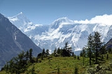
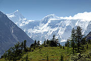
The north western and northern slopes of the Sailughem Mountains are extremely steep and difficult to access. On this side lies the highest summit of the range, the double-headed Belukha, whose summits reach 4,506 and 4,440 m respectively, and give origin to several glacier
s (30 square kilometeres in aggregate area, as of 1911). Altaians call it Kadyn Bazhy, but is also called Uch-Sumer.
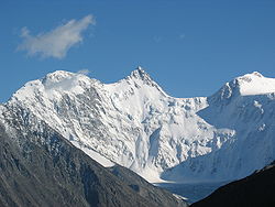
The second highest peak of the range is in Mongolian part named Khüiten Peak
. This massive reaches 4374 m. Numerous spurs, striking in all directions from the Sailughem mountains, fill up the space between that range and the lowlands of Tomsk
. Such are the Chuya Alps
, having an average altitude of 2,700 m, with summits from 3,500 to 3,700 m, and at least ten glaciers on their northern slope; the Katun Alps, which have a mean elevation of about 3,000 m and are mostly snow-clad; the Kholzun range; the Korgon 1,900 to 2,300 m, Talitskand Selitsk ranges; the Tigeretsk Alps.
Several secondary plateaus of lower altitude are also distinguished by geographers, The Katun valley begins as a wild gorge on the south-west slope of Belukha; then, after a big bend, the river (600 km long) pierces the Katun Alps, and enters a wider valley, lying at an altitude of from 600 to 1,100 m, which it follows until it emerges from the Altai highlands to join the Biya
in a most picturesque region. The Katun and the Biya together form the Ob
.
The next valley is that of the Charysh, which has the Korgon and Tigeretsk Alps on one side and the Talitsk and Bashalatsk Alps on the other. This, too, is very fertile. The Altai, seen from this valley, presents the most romantic scenes, including the small but deep Kolyvan lake (altitude 360 m), which is surrounded by fantastic granite dome
s and towers.
Farther west the valleys of the Uba
, the Ulba and the Bukhtarma open south-westwards towards the Irtysh. The lower part of the first, like the lower valley of the Charysh, is thickly populated; in the valley of the Ulba is the Riddersk mine, at the foot of the Ivanovsk Peak (2,060 m), clothed with alpine meadows. The valley of the Bukhtarma, which has a length of 320 km, also has its origin at the foot of the Belukha and the Kuitun
peaks, and as it falls some 1,500 m in about 300 km, from an alpine plateau at an elevation of 1,900 m to the Bukhtarma fortress (345 m), it offers the most striking contrasts of landscape and vegetation. Its upper parts abound in glaciers, the best known of which is the Berel
, which comes down from the Byelukha. On the northern side of the range which separates the upper Bukhtarma from the upper Katun is the Katun glacier, which after two ice-falls widens out to 700 to 900 metres. From a grotto in this glacier bursts tumultuously the Katun river.
The middle and lower parts of the Bukhtarma valley have been colonized since the 18th century by runaway Russian peasants, serfs and religious schism
atics (Raskolniks), who created a free republic there on Chinese territory
; and after this part of the valley was annexed to Russia
in 1869, it was rapidly colonized. The high valleys farther north, on the same western face of the Sailughem range, are but little known, their only visitors being Kyrgyz shepherds.
Those of Bashkaus
, Chulyshman, and Chulcha, all three leading to the alpine lake of Teletskoye
(length, 80 km; maximum width, 5 km; altitude, 520 m; area, 230.8 square kilometeres; maximum depth, 310 m; mean depth, 200 m), are inhabited by Telengit
people. The shores of the lake rise almost sheer to over 1,800 m. From this lake issues the Biya, which joins the Katun at Biysk
, and then meanders through the prairies of the north-west of the Altai.
Farther north the Altai highlands are continued in the Kuznetsk district, which has a slightly different geological aspect, but still belongs to the Altai system. But the Abakan River
, which rises on the western shoulder of the Sayan mountains, belongs to the system of the Yenisei. The Kuznetsk Ala-tau range, on the left bank of the Abakan, runs north-east into the government of Yeniseisk, while a complexus of mountains (Chukchut, Salair, Abakan) fills up the country northwards towards the Trans-Siberian Railway
and westwards towards the Ob
.
The Ek-tagh or Mongolian Altai, which separates the Khovd basin on the north from the Irtysh basin on the south, is a true border-range, in that it rises in a steep and lofty escarpment
from the Dzungaria
n depression (470–900 m), but descends on the north by a relatively short slope to the plateau (1,150 to 1,680 m) of north-western Mongolia
. East of 94° E the range is continued by a double series of mountain chains, all of which exhibit less sharply marked orographical
features and are at considerably lower elevations. The slopes of the constituent chains of the system are inhabited principally by nomadic Kyrgyz.
, dating to 40,000 years ago, was discovered in the Denisova Cave
of the Altai mountains in southern Siberia. A dog-like canid from 33,000 years ago was found in the Razboinichya Cave.
The Altai Mountains have been identified as being the point of origin of a cultural enigma termed the Seima-Turbino Phenomenon
which arose during the Bronze Age
around the start of the 2nd millennium BC
and led to a rapid and massive migration of peoples from the region into distant parts of Europe
and Asia
.
, Mount Belukha and the Ukok Plateau
- comprise a natural UNESCO
World Heritage Site
entitled Golden Mountains of Altai
. As stated in the UNESCO description of the site, "the region represents the most complete sequence of altitudinal vegetation zones in central Siberia, from steppe, forest-steppe, mixed forest, subalpine vegetation to alpine vegetation". While making its decision, UNESCO also cited Russian Altai's importance for preservation of the globally endangered mammals, such as snow leopard
and the Altai argali
. Siberian Ibex
also live in these mountains. The Uvs Nuur basin is also a protected site.
Violations of the protection status of Argali sheep and other species have been alleged, together with accusations of corruption, in the Altaigate Scandal
. The incident arose from the death of several Russian VIPs in a helicopter crash early in 2009, purportedly on a poaching excursion.
 The Siberian Altai represents the northern most region affected by the tectonic collision of India into Asia. Massive fault systems run through the area, including the Kurai fault zone and the recently identified Tashanta fault zone. These fault systems are typically thrusts or right lateral strike-slip faults, some of which are tectonically active. Rock types in the mountains are typically granites and metamorphic schists, and some are highly sheared near to fault zones.
, measuring MW 7.3, occurred in the Chuya Basin
area to the south of the Altai region. Seismic activity is however a rare occurrence. This earthquake and its aftershock
s devastated much of the region, causing $10.6 million in damage (USGS) and wiping out the village of Beltir.
Mountain range
A mountain range is a single, large mass consisting of a succession of mountains or narrowly spaced mountain ridges, with or without peaks, closely related in position, direction, formation, and age; a component part of a mountain system or of a mountain chain...
in East
East Asia
East Asia or Eastern Asia is a subregion of Asia that can be defined in either geographical or cultural terms...
-Central
Central Asia
Central Asia is a core region of the Asian continent from the Caspian Sea in the west, China in the east, Afghanistan in the south, and Russia in the north...
Asia, where Russia
Russia
Russia or , officially known as both Russia and the Russian Federation , is a country in northern Eurasia. It is a federal semi-presidential republic, comprising 83 federal subjects...
, China
China
Chinese civilization may refer to:* China for more general discussion of the country.* Chinese culture* Greater China, the transnational community of ethnic Chinese.* History of China* Sinosphere, the area historically affected by Chinese culture...
, Mongolia
Mongolia
Mongolia is a landlocked country in East and Central Asia. It is bordered by Russia to the north and China to the south, east and west. Although Mongolia does not share a border with Kazakhstan, its western-most point is only from Kazakhstan's eastern tip. Ulan Bator, the capital and largest...
and Kazakhstan
Kazakhstan
Kazakhstan , officially the Republic of Kazakhstan, is a transcontinental country in Central Asia and Eastern Europe. Ranked as the ninth largest country in the world, it is also the world's largest landlocked country; its territory of is greater than Western Europe...
come together, and where the river
River
A river is a natural watercourse, usually freshwater, flowing towards an ocean, a lake, a sea, or another river. In a few cases, a river simply flows into the ground or dries up completely before reaching another body of water. Small rivers may also be called by several other names, including...
s Irtysh
Irtysh
The Irtysh River is a river in Siberia and is the chief tributary of the Ob River. Its name means White River. Irtysh's main affluent is the Tobol River...
and Ob
Ob River
The Ob River , also Obi, is a major river in western Siberia, Russia and is the world's seventh longest river. It is the westernmost of the three great Siberian rivers that flow into the Arctic Ocean .The Gulf of Ob is the world's longest estuary.-Names:The Ob is known to the Khanty people as the...
have their sources. The Altai Mountains are known as the original locus of the speakers of Turkic
Turkic languages
The Turkic languages constitute a language family of at least thirty five languages, spoken by Turkic peoples across a vast area from Eastern Europe and the Mediterranean to Siberia and Western China, and are considered to be part of the proposed Altaic language family.Turkic languages are spoken...
as well as other members of the proposed Altaic language group. The northwest end of the range is at 52° N and between 84° and 90° E (where it merges with the Sayan Mountains
Sayan Mountains
The Sayan Mountains are a mountain range between northwestern Mongolia and southern Siberia, Russia.The Eastern Sayan extends from the Yenisei River at 92° E to the southwest end of Lake Baikal at 106° E...
to the east), and extends southeast from there to about 45° N and 99° E, where it gradually becomes lower and merges into the high plateau of the Gobi Desert
Gobi Desert
The Gobi is a large desert region in Asia. It covers parts of northern and northwestern China, and of southern Mongolia. The desert basins of the Gobi are bounded by the Altai Mountains and the grasslands and steppes of Mongolia on the north, by the Hexi Corridor and Tibetan Plateau to the...
.
The name, in Turkic Alytau or Altai, means Al (gold), tau (mount); in Mongolian
Mongolian language
The Mongolian language is the official language of Mongolia and the best-known member of the Mongolic language family. The number of speakers across all its dialects may be 5.2 million, including the vast majority of the residents of Mongolia and many of the Mongolian residents of the Inner...
Altain nuruu, the "Mountains of Gold". The proposed Altaic language family
Altaic languages
Altaic is a proposed language family that includes the Turkic, Mongolic, Tungusic, and Japonic language families and the Korean language isolate. These languages are spoken in a wide arc stretching from northeast Asia through Central Asia to Anatolia and eastern Europe...
takes its name from the mountain range.
Geography
(For the area north of the Altai, see Geography of South-Central SiberiaGeography of South-Central Siberia
This article covers the region of Siberia west of Lake Baikal and north of the Altai Mountains. It is intended totie together a number of articles that are hard to understand in isolation....
.)
Sayan Mountains
The Sayan Mountains are a mountain range between northwestern Mongolia and southern Siberia, Russia.The Eastern Sayan extends from the Yenisei River at 92° E to the southwest end of Lake Baikal at 106° E...
in 51° 60' N and 89° E. Their mean elevation is 1,500 to 1,750 m. The snow-line runs at 2,000 m on the northern side and at 2,400 m on the southern, and above it the rugged peaks tower up some 1,000 m more. Mountain pass
Mountain pass
A mountain pass is a route through a mountain range or over a ridge. If following the lowest possible route, a pass is locally the highest point on that route...
es across the range are few and difficult, the chief being the Ulan-daban at 2,827 m (2,879 m according to Kozlov), and the Chapchan-daban, at 3,217 m, in the south and north respectively. On the east
East
East is a noun, adjective, or adverb indicating direction or geography.East is one of the four cardinal directions or compass points. It is the opposite of west and is perpendicular to north and south.By convention, the right side of a map is east....
and southeast this range is flanked by the great plateau
Plateau
In geology and earth science, a plateau , also called a high plain or tableland, is an area of highland, usually consisting of relatively flat terrain. A highly eroded plateau is called a dissected plateau...
of Mongolia, the transition being effected gradually by means of several minor plateaus, such as Ukok
Ukok Plateau
Ukok Plateau is a remote and pristine grasslands area located in the heart of southwestern Siberia, the Altai Mountains region of Russia near the borders with China, Kazakhstan and Mongolia...
2380 m with Pazyryk Valley, Chuya 1,830 m, Kendykty 2,500 m, Kak 2,520 m, Suok 2,590 m, and Juvlu-kul 2,410 m.
This region is studded with large lake
Lake
A lake is a body of relatively still fresh or salt water of considerable size, localized in a basin, that is surrounded by land. Lakes are inland and not part of the ocean and therefore are distinct from lagoons, and are larger and deeper than ponds. Lakes can be contrasted with rivers or streams,...
s, e.g. Uvs 720 m above sea level
Sea level
Mean sea level is a measure of the average height of the ocean's surface ; used as a standard in reckoning land elevation...
, Khyargas, Dorgon and Khar 1,170 m, and traversed by various mountain range
Mountain range
A mountain range is a single, large mass consisting of a succession of mountains or narrowly spaced mountain ridges, with or without peaks, closely related in position, direction, formation, and age; a component part of a mountain system or of a mountain chain...
s, of which the principal are the Tannu-Ola Mountains
Tannu-Ola Mountains
The Tannu-Ola mountains is a mountain range in southern Siberia, in the Tuva Republic of Russia. It extends in an east-west direction and curves along the Mongolian border...
, running roughly parallel with the Sayan Mountains
Sayan Mountains
The Sayan Mountains are a mountain range between northwestern Mongolia and southern Siberia, Russia.The Eastern Sayan extends from the Yenisei River at 92° E to the southwest end of Lake Baikal at 106° E...
as far east as the Kosso-gol, and the Khan Khökhii mountains, also stretching west and east.
The north western and northern slopes of the Sailughem Mountains are extremely steep and difficult to access. On this side lies the highest summit of the range, the double-headed Belukha, whose summits reach 4,506 and 4,440 m respectively, and give origin to several glacier
Glacier
A glacier is a large persistent body of ice that forms where the accumulation of snow exceeds its ablation over many years, often centuries. At least 0.1 km² in area and 50 m thick, but often much larger, a glacier slowly deforms and flows due to stresses induced by its weight...
s (30 square kilometeres in aggregate area, as of 1911). Altaians call it Kadyn Bazhy, but is also called Uch-Sumer.
The second highest peak of the range is in Mongolian part named Khüiten Peak
Khüiten Peak
Hüiten Peak is the highest point in Mongolia, located in the far west of the country on the border with PRC. The Peak towers at the elevation of 4,374 m under the permanent snow-cap...
. This massive reaches 4374 m. Numerous spurs, striking in all directions from the Sailughem mountains, fill up the space between that range and the lowlands of Tomsk
Tomsk
Tomsk is a city and the administrative center of Tomsk Oblast, Russia, located on the Tom River. One of the oldest towns in Siberia, Tomsk celebrated its 400th anniversary in 2004...
. Such are the Chuya Alps
Chuya Alps
The Chuya Alps are part of the Altay mountain range, straddling the border of Russia and Kazakhstan close to the region where their borders and those of China and Mongolia meet. They have an average altitude of about 9000 ft with summits ranging from 11,500 to 12,000 ft. There are about...
, having an average altitude of 2,700 m, with summits from 3,500 to 3,700 m, and at least ten glaciers on their northern slope; the Katun Alps, which have a mean elevation of about 3,000 m and are mostly snow-clad; the Kholzun range; the Korgon 1,900 to 2,300 m, Talitskand Selitsk ranges; the Tigeretsk Alps.
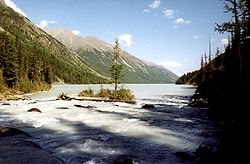
Several secondary plateaus of lower altitude are also distinguished by geographers, The Katun valley begins as a wild gorge on the south-west slope of Belukha; then, after a big bend, the river (600 km long) pierces the Katun Alps, and enters a wider valley, lying at an altitude of from 600 to 1,100 m, which it follows until it emerges from the Altai highlands to join the Biya
Biya River
The Biya River is a river in the Altai Republic and Altai Krai in Russia. It forms the Ob River as it joins the Katun River. The Biya River is 301 km long; the area of its drainage basin is 37,000 km². It flows out of the Teletskoye Lake. The river freezes up in the mid-November to early December...
in a most picturesque region. The Katun and the Biya together form the Ob
Ob River
The Ob River , also Obi, is a major river in western Siberia, Russia and is the world's seventh longest river. It is the westernmost of the three great Siberian rivers that flow into the Arctic Ocean .The Gulf of Ob is the world's longest estuary.-Names:The Ob is known to the Khanty people as the...
.
The next valley is that of the Charysh, which has the Korgon and Tigeretsk Alps on one side and the Talitsk and Bashalatsk Alps on the other. This, too, is very fertile. The Altai, seen from this valley, presents the most romantic scenes, including the small but deep Kolyvan lake (altitude 360 m), which is surrounded by fantastic granite dome
Granite dome
A granite dome is a dome of granite, formed by exfoliation.-Formation:Granite forms plutons of igneous rock several kilometers below the surface as magma slowly cools and crystallizes. The granite is under great overhead pressure....
s and towers.
Farther west the valleys of the Uba
UBA
-Abbreviations:* "Underwater Breathing Apparatus", some types of rebreather scuba set. For early British UBA's see Siebe Gorman CDBA.* Union Belge De L'Automatique, the Belgian branch of EUROMAT* Unit of Binding Atoms...
, the Ulba and the Bukhtarma open south-westwards towards the Irtysh. The lower part of the first, like the lower valley of the Charysh, is thickly populated; in the valley of the Ulba is the Riddersk mine, at the foot of the Ivanovsk Peak (2,060 m), clothed with alpine meadows. The valley of the Bukhtarma, which has a length of 320 km, also has its origin at the foot of the Belukha and the Kuitun
Kuitun
Kuytun or Kuitun is a county-level city with about 285,000 residents in Ili Kazakh Autonomous Prefecture, Xinjiang. Kuitun is located between Wusu and Shihezi on the railway from Urumqi to Kazakhstan, close to a desert....
peaks, and as it falls some 1,500 m in about 300 km, from an alpine plateau at an elevation of 1,900 m to the Bukhtarma fortress (345 m), it offers the most striking contrasts of landscape and vegetation. Its upper parts abound in glaciers, the best known of which is the Berel
Berel
Berel is a given name. It may refer to:*Berel Wein, American-born Orthodox rabbi, scholar, lecturer, and writer*Berel Lazar, Orthodox rabbi, one of two claimants to the title "Chief Rabbi of Russia"...
, which comes down from the Byelukha. On the northern side of the range which separates the upper Bukhtarma from the upper Katun is the Katun glacier, which after two ice-falls widens out to 700 to 900 metres. From a grotto in this glacier bursts tumultuously the Katun river.
The middle and lower parts of the Bukhtarma valley have been colonized since the 18th century by runaway Russian peasants, serfs and religious schism
Schism (religion)
A schism , from Greek σχίσμα, skhísma , is a division between people, usually belonging to an organization or movement religious denomination. The word is most frequently applied to a break of communion between two sections of Christianity that were previously a single body, or to a division within...
atics (Raskolniks), who created a free republic there on Chinese territory
China
Chinese civilization may refer to:* China for more general discussion of the country.* Chinese culture* Greater China, the transnational community of ethnic Chinese.* History of China* Sinosphere, the area historically affected by Chinese culture...
; and after this part of the valley was annexed to Russia
Russia
Russia or , officially known as both Russia and the Russian Federation , is a country in northern Eurasia. It is a federal semi-presidential republic, comprising 83 federal subjects...
in 1869, it was rapidly colonized. The high valleys farther north, on the same western face of the Sailughem range, are but little known, their only visitors being Kyrgyz shepherds.
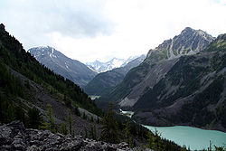
Those of Bashkaus
Bashkaus River
The Bashkaus is a river in the Altai Republic in Siberia, Russia. It is a left tributary of the Chulyshman river, which flows into Lake Teletskoye . The length of the Bashkaus River is 219 km. The area of its basin is 7,770 km²....
, Chulyshman, and Chulcha, all three leading to the alpine lake of Teletskoye
Lake Teletskoye
Lake Teletskoye is the largest lake in the Altay Mountains and the Altai Republic, Russia, and has a depth of up to 325 meters.Situated at a height of 434 m above sea level, the lake is long and wide and lies between the mountain ridges Korbu and Al-tyntu, on the junction of Sailughem Mountains...
(length, 80 km; maximum width, 5 km; altitude, 520 m; area, 230.8 square kilometeres; maximum depth, 310 m; mean depth, 200 m), are inhabited by Telengit
Telengit
Telengits or Telengut are a Turkic people people primarily found in Altai Republic, Russia. Telengits mainly live in a territory of Kosh-Agach District of the Altai Republic. They are part of a larger cultural group of the Southern Altaians...
people. The shores of the lake rise almost sheer to over 1,800 m. From this lake issues the Biya, which joins the Katun at Biysk
Biysk
Biysk is a city in Altai Krai, Russia. It is the second largest city of the krai . Population: -Geography:Biysk is situated in southwestern Siberia, on the Biya River . The city is called "the gates to the Altai Mountains", because of its position comparatively not far from this range...
, and then meanders through the prairies of the north-west of the Altai.
Farther north the Altai highlands are continued in the Kuznetsk district, which has a slightly different geological aspect, but still belongs to the Altai system. But the Abakan River
Abakan River
The Abakan , the Khakas word for 'bear's blood', is a river in the Republic of Khakassia, Russia formed by the confluence of the Bolshoy Abakan and Maly Abakan Rivers. It rises in the western Sayan Mountains and flows northeast through the Minusinsk Depression to the Yenisei River...
, which rises on the western shoulder of the Sayan mountains, belongs to the system of the Yenisei. The Kuznetsk Ala-tau range, on the left bank of the Abakan, runs north-east into the government of Yeniseisk, while a complexus of mountains (Chukchut, Salair, Abakan) fills up the country northwards towards the Trans-Siberian Railway
Trans-Siberian Railway
The Trans-Siberian Railway is a network of railways connecting Moscow with the Russian Far East and the Sea of Japan. It is the longest railway in the world...
and westwards towards the Ob
Ob River
The Ob River , also Obi, is a major river in western Siberia, Russia and is the world's seventh longest river. It is the westernmost of the three great Siberian rivers that flow into the Arctic Ocean .The Gulf of Ob is the world's longest estuary.-Names:The Ob is known to the Khanty people as the...
.
The Ek-tagh or Mongolian Altai, which separates the Khovd basin on the north from the Irtysh basin on the south, is a true border-range, in that it rises in a steep and lofty escarpment
Escarpment
An escarpment is a steep slope or long cliff that occurs from erosion or faulting and separates two relatively level areas of differing elevations.-Description and variants:...
from the Dzungaria
Dzungaria
Dzungaria, also called Zungaria, is a geographical region in northwest China corresponding to the northern half of Xinjiang. It covers approximately , lying mostly within Xinjiang, and extending into western Mongolia and eastern Kazakhstan...
n depression (470–900 m), but descends on the north by a relatively short slope to the plateau (1,150 to 1,680 m) of north-western Mongolia
Mongolia
Mongolia is a landlocked country in East and Central Asia. It is bordered by Russia to the north and China to the south, east and west. Although Mongolia does not share a border with Kazakhstan, its western-most point is only from Kazakhstan's eastern tip. Ulan Bator, the capital and largest...
. East of 94° E the range is continued by a double series of mountain chains, all of which exhibit less sharply marked orographical
Orography
Orography is the study of the formation and relief of mountains, and can more broadly include hills, and any part of a region's elevated terrain...
features and are at considerably lower elevations. The slopes of the constituent chains of the system are inhabited principally by nomadic Kyrgyz.
History
The Denisova homininDenisova hominin
Denisova hominins , or Denisovans, are Paleolithic-Era members of the genus Homo that may belong to a previously unknown species. In , scientists announced the discovery of a finger bone fragment of a juvenile female that lived about 41,000 years ago, found in Denisova Cave in Altai Krai, Russia, a...
, dating to 40,000 years ago, was discovered in the Denisova Cave
Denisova Cave
Denisova Cave is a cave in the Bashelaksky Range of the Altai mountains, Siberia, Russia. The cave is of paleoarchaeological and paleontological interest. Bone fragments of the Denisova hominin, sometime called the "X-woman" originate from the cave, including artifacts dated to ~40,000 Before...
of the Altai mountains in southern Siberia. A dog-like canid from 33,000 years ago was found in the Razboinichya Cave.
The Altai Mountains have been identified as being the point of origin of a cultural enigma termed the Seima-Turbino Phenomenon
Seima-Turbino Phenomenon
Seima-Turbino refers to burial sites dating around 1500 BC found across northern Eurasia, from Finland to Mongolia. The buried were nomadic warriors and metal-workers, travelling on horseback or two-wheeled chariots. These nomads originated from the Altai Mountains...
which arose during the Bronze Age
Bronze Age
The Bronze Age is a period characterized by the use of copper and its alloy bronze as the chief hard materials in the manufacture of some implements and weapons. Chronologically, it stands between the Stone Age and Iron Age...
around the start of the 2nd millennium BC
2nd millennium BC
The 2nd millennium BC marks the transition from the Middle to the Late Bronze Age.Its first half is dominated by the Middle Kingdom of Egypt and Babylonia. The alphabet develops. Indo-Iranian migration onto the Iranian plateau and onto the Indian subcontinent propagates the use of the chariot...
and led to a rapid and massive migration of peoples from the region into distant parts of Europe
Europe
Europe is, by convention, one of the world's seven continents. Comprising the westernmost peninsula of Eurasia, Europe is generally 'divided' from Asia to its east by the watershed divides of the Ural and Caucasus Mountains, the Ural River, the Caspian and Black Seas, and the waterways connecting...
and Asia
Asia
Asia is the world's largest and most populous continent, located primarily in the eastern and northern hemispheres. It covers 8.7% of the Earth's total surface area and with approximately 3.879 billion people, it hosts 60% of the world's current human population...
.
World Heritage site
A vast area of 16,178 km² - Altai and Katun Natural Reserves, Lake TeletskoyeLake Teletskoye
Lake Teletskoye is the largest lake in the Altay Mountains and the Altai Republic, Russia, and has a depth of up to 325 meters.Situated at a height of 434 m above sea level, the lake is long and wide and lies between the mountain ridges Korbu and Al-tyntu, on the junction of Sailughem Mountains...
, Mount Belukha and the Ukok Plateau
Ukok Plateau
Ukok Plateau is a remote and pristine grasslands area located in the heart of southwestern Siberia, the Altai Mountains region of Russia near the borders with China, Kazakhstan and Mongolia...
- comprise a natural UNESCO
UNESCO
The United Nations Educational, Scientific and Cultural Organization is a specialized agency of the United Nations...
World Heritage Site
World Heritage Site
A UNESCO World Heritage Site is a place that is listed by the UNESCO as of special cultural or physical significance...
entitled Golden Mountains of Altai
Golden Mountains of Altai
Golden Mountains of Altai is the name of an UNESCO World Heritage Site consisting of the Altai and Katun Natural Reserves, Lake Teletskoye, Belukha Mountain, and the Ukok Plateau...
. As stated in the UNESCO description of the site, "the region represents the most complete sequence of altitudinal vegetation zones in central Siberia, from steppe, forest-steppe, mixed forest, subalpine vegetation to alpine vegetation". While making its decision, UNESCO also cited Russian Altai's importance for preservation of the globally endangered mammals, such as snow leopard
Snow Leopard
The snow leopard is a moderately large cat native to the mountain ranges of South Asia and Central Asia...
and the Altai argali
Altai argali
Altai argali is a traditional subspecies of argali, wild sheep that roam the highlands of Altai Mountains.Altai argali are the largest of all sheep, with the heaviest horns, those of mature males normally 45-50 and up to 75 pounds ....
. Siberian Ibex
Siberian Ibex
The Siberian Ibex or Common ibex is a species of ibex that lives in central and northern Asia. It has traditionally been treated as a subspecies of the Alpine Ibex, and whether it is specifically distinct from other ibex is still not entirely clear...
also live in these mountains. The Uvs Nuur basin is also a protected site.
Violations of the protection status of Argali sheep and other species have been alleged, together with accusations of corruption, in the Altaigate Scandal
Altaigate Scandal
The Altaigate Scandal is the name given to the events surrounding the 9 January 2009 disappearance of an Mi-171 helicopter in the south of the Altai Republic. The helicopter contained several VIP passengers. The helicopter was found as a result of large-scale rescue operations on 11 January 2009...
. The incident arose from the death of several Russian VIPs in a helicopter crash early in 2009, purportedly on a poaching excursion.
Geology
Seismic activity
On 27 September 2003 a massive earthquakeEarthquake
An earthquake is the result of a sudden release of energy in the Earth's crust that creates seismic waves. The seismicity, seismism or seismic activity of an area refers to the frequency, type and size of earthquakes experienced over a period of time...
, measuring MW 7.3, occurred in the Chuya Basin
Chuya Basin
The Chuya Steppe in the Siberian Altai Mountains is a depression formed by tectonic movement of major faults in the Earths crust. The name 'Chuya Steppe' comes from the large river which runs through the steppe, the Chuya River.-Major Towns:...
area to the south of the Altai region. Seismic activity is however a rare occurrence. This earthquake and its aftershock
Aftershock
An aftershock is a smaller earthquake that occurs after a previous large earthquake, in the same area of the main shock. If an aftershock is larger than the main shock, the aftershock is redesignated as the main shock and the original main shock is redesignated as a foreshock...
s devastated much of the region, causing $10.6 million in damage (USGS) and wiping out the village of Beltir.
See also
- Altai KraiAltai KraiAltai Krai is a federal subject of Russia . It borders with, clockwise from the south, Kazakhstan, Novosibirsk and Kemerovo Oblasts, and the Altai Republic. The krai's administrative center is the city of Barnaul...
- Altaic languagesAltaic languagesAltaic is a proposed language family that includes the Turkic, Mongolic, Tungusic, and Japonic language families and the Korean language isolate. These languages are spoken in a wide arc stretching from northeast Asia through Central Asia to Anatolia and eastern Europe...
- Altay languageAltay languageAltay is a language of the Turkic group of languages. It is an official language of Altai Republic, Russia. The language was called Oyrot prior to 1948. There were ca...
External links
- "Ancient spirit and might preserved by indigenous people of Altay." RT. November 6, 2011.
- Photos of Mountain Altai - Altai-Photo
- Altai-Project of the Technical University of Dresden - Institute of Cartography
- Golden Mountains of Altai at Natural Heritage Protection Fund
- UNESCO's evaluation of Altai (PDF file)