
Yenisei River
Overview
River
A river is a natural watercourse, usually freshwater, flowing towards an ocean, a lake, a sea, or another river. In a few cases, a river simply flows into the ground or dries up completely before reaching another body of water. Small rivers may also be called by several other names, including...
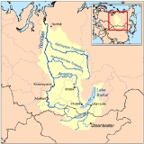
system flowing to the Arctic Ocean
Arctic Ocean
The Arctic Ocean, located in the Northern Hemisphere and mostly in the Arctic north polar region, is the smallest and shallowest of the world's five major oceanic divisions...
. It is the central of the three great Siberia
Siberia
Siberia is an extensive region constituting almost all of Northern Asia. Comprising the central and eastern portion of the Russian Federation, it was part of the Soviet Union from its beginning, as its predecessor states, the Tsardom of Russia and the Russian Empire, conquered it during the 16th...
n river
River
A river is a natural watercourse, usually freshwater, flowing towards an ocean, a lake, a sea, or another river. In a few cases, a river simply flows into the ground or dries up completely before reaching another body of water. Small rivers may also be called by several other names, including...
s that flow into the Arctic Ocean (the other two being the Ob River
Ob River
The Ob River , also Obi, is a major river in western Siberia, Russia and is the world's seventh longest river. It is the westernmost of the three great Siberian rivers that flow into the Arctic Ocean .The Gulf of Ob is the world's longest estuary.-Names:The Ob is known to the Khanty people as the...
and the Lena River
Lena River
The Lena is the easternmost of the three great Siberian rivers that flow into the Arctic Ocean . It is the 11th longest river in the world and has the 9th largest watershed...
). Rising in Mongolia
Mongolia
Mongolia is a landlocked country in East and Central Asia. It is bordered by Russia to the north and China to the south, east and west. Although Mongolia does not share a border with Kazakhstan, its western-most point is only from Kazakhstan's eastern tip. Ulan Bator, the capital and largest...
, it follows a northerly course to the Yenisei Gulf
Yenisei Gulf
The Yenisei Gulf is a large and long estuary through which the lower Yenisei River flows into the Kara Sea.The Yenisei Gulf is formed by the river widening to an average of 50 km for up to 250 km in a roughly north-south direction, between a latitude of 70° 30' N in the area around...
in the Kara Sea
Kara Sea
The Kara Sea is part of the Arctic Ocean north of Siberia. It is separated from the Barents Sea to the west by the Kara Strait and Novaya Zemlya, and the Laptev Sea to the east by the Severnaya Zemlya....
, draining a large part of central Siberia
Siberia
Siberia is an extensive region constituting almost all of Northern Asia. Comprising the central and eastern portion of the Russian Federation, it was part of the Soviet Union from its beginning, as its predecessor states, the Tsardom of Russia and the Russian Empire, conquered it during the 16th...
, the longest stream following the Yenisei-Angara
Angara
The Angara River is a long river in Irkutsk Oblast and Krasnoyarsk Krai, south-east Siberia, Russia. It is the only river flowing out of Lake Baikal, and is the headwater tributary of the Yenisei River....
-Selenga
Selenga
The Selenge is a major river in Mongolia and Buryatia, Russia. Its source rivers are the Ider River and the Delgermörön river. It flows into Lake Baikal and has a length of 616 miles...
-Ider river system.
The upper reaches, subject to rapids and flooding, pass through sparsely populated areas.
Unanswered Questions