
Diomede Islands
Encyclopedia
The Diomede Islands also known in Russia
as Gvozdev Islands , consist of two rocky, tuya
-like islands:
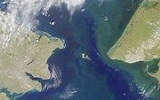
The Diomede Islands are located in the middle of the Bering Strait
between mainland Alaska
and Siberia
, with the Chukchi Sea
to the north and the Bering Sea
to the south. 9.3 km (5.8 mi) to the southeast is Fairway Rock
, which is generally not considered part of the Diomede Islands. The islands are sometimes called Tomorrow Island (Big Diomede) and Yesterday Isle (Little Diomede) because the time in Big Diomede is 20 hours (approximately a day) ahead of Little Diomede.
, approximately 2 km (1.2 mi) from each island, at 168°58'37"W. At the closest distance between Little Diomede and Big Diomede, the two islands are about 3.8 km (2.4 mi) apart. The small habitation on Little Diomede Island is centered on the west
side of the island at the village of Diomede
.
The Big Diomede Island is considered the easternmost point of Russia
.
The Diomede Islands are often mentioned as likely intermediate stops for a bridge
or tunnel
(Bering Strait bridge
) spanning the Bering Strait
.
in 1648. He reported two islands whose natives had bone lip ornaments, but it is not certain that these were the Diomedes. A Danish navigator (in Russian service), Vitus Bering
, re-discovered the Diomede Islands on 16 August (O.S., 26 August N.S.) 1728, the day when the Russian Orthodox Church
celebrates the memory of the martyr St. Diomede (hence, the name of the islands). In 1732, a Russian geodesist, Mikhail Gvozdev
, plotted the islands on the map (hence, another name).
The text of the 1867 treaty finalizing the sale of Alaska
uses the islands to designate the boundary between the two nations: The border separates "equidistantly Krusenstern Island, or Ignaluk, from Ratmanov Island, or Nunarbuk, and heads northward infinitely until it disappears completely in the Arctic Ocean."
During the Cold War
, that gap constituted the border between the USA and the USSR, and became known as the "Ice Curtain". In 1987, however, Lynne Cox
swam from one island to the other, and was congratulated by Mikhail Gorbachev
and Ronald Reagan
.
In summer 1995, British television actor and documentary presenter Michael Palin
started his counterclockwise circumnavigation of the Pacific Rim, encompassing 18 different countries, on Little Diomede Island, as part of the BBC series Full Circle
. He intended to set foot on it again at the very end of his journey lasting nearly eight months, but was unable to do so because he was returning during the following winter (on the U.S. Coast Guard
Cutter
Munro
), and the sea became too rough to allow him and his film crew to land on the island.
Big Diomede Island was traditionally the easternmost landmass before the International Date Line
, and the first landmass to ring in a new year, if using local solar time. When using official time, a large area in eastern Russia, as well as New Zealand
, shares the same time zone. New Zealand also has Daylight Saving time in effect during late December, but Russia does not (see time in New Zealand
and time in Russia
). Starting in 1995 however, the IDL was moved to the east of Kiribati
and that country's easternmost time zone (GMT+14) is now the world's earliest.
The native population of Big Diomede Island was relocated by the Soviet government to mainland Russia and the island is currently home to a small Russian military presence. Little Diomede has an Inupiat Inuit population of 170, entirely in the village site on the west side of the island, though the island as a whole comprises the City of Diomede
. This village has a school and a store. Some Inuit residents are famous for their ivory carving
. Passenger travel and mail delivery is by helicopter, weather permitting.
Russia
Russia or , officially known as both Russia and the Russian Federation , is a country in northern Eurasia. It is a federal semi-presidential republic, comprising 83 federal subjects...
as Gvozdev Islands , consist of two rocky, tuya
Tuya
A tuya is a type of distinctive, flat-topped, steep-sided volcano formed when lava erupts through a thick glacier or ice sheet. They are somewhat rare worldwide, being confined to regions which were covered by glaciers and also had active volcanism during the same time period.-Formation:Tuyas are...
-like islands:
- The U.S.United StatesThe United States of America is a federal constitutional republic comprising fifty states and a federal district...
island of Little Diomede or, in its native languageInupiaq languageThe Inupiat language, also known as Inupiatun, Inupiaq, Iñupiaq, Inyupiaq, Inyupiat, Inyupeat, Inyupik, and Inupik, is a group of dialects of the Inuit language, spoken in northern and northwestern Alaska. The Iñupiaq language is a member of the Eskimo languages group. There are roughly 2,100...
, Ignaluk (it is also known as Krusenstern Island, though this may also refer to other placesKrusenstern IslandKrusenstern Island is a toponym honoring the Baltic German explorer Adam Johann von Krusenstern . It was and sometimes still is used for a number of places in the Pacific Ocean:* Ailuk in the Marshall Islands...
), and - The RussiaRussiaRussia or , officially known as both Russia and the Russian Federation , is a country in northern Eurasia. It is a federal semi-presidential republic, comprising 83 federal subjects...
n island of Big DiomedeBig DiomedeBig Diomede Island is an unpopulated island among the Diomede Islands in the middle of the Bering Strait. The island is a part of the Chukotsky District of the Chukotka Autonomous Okrug of Russia.-Geography:...
(part of Chukotka Autonomous OkrugChukotka Autonomous OkrugChukotka Autonomous Okrug , or Chukotka , is a federal subject of Russia located in the Russian Far East.Chukotka has a population of 53,824 according to the 2002 Census, and a surface area of . The principal town and the administrative center is Anadyr...
), also known as Imaqliq, Inaliq, Nunarbuk or Ratmanov Island.
The Diomede Islands are located in the middle of the Bering Strait
Bering Strait
The Bering Strait , known to natives as Imakpik, is a sea strait between Cape Dezhnev, Chukotka Autonomous Okrug, Russia, the easternmost point of the Asian continent and Cape Prince of Wales, Alaska, USA, the westernmost point of the North American continent, with latitude of about 65°40'N,...
between mainland Alaska
Alaska
Alaska is the largest state in the United States by area. It is situated in the northwest extremity of the North American continent, with Canada to the east, the Arctic Ocean to the north, and the Pacific Ocean to the west and south, with Russia further west across the Bering Strait...
and Siberia
Siberia
Siberia is an extensive region constituting almost all of Northern Asia. Comprising the central and eastern portion of the Russian Federation, it was part of the Soviet Union from its beginning, as its predecessor states, the Tsardom of Russia and the Russian Empire, conquered it during the 16th...
, with the Chukchi Sea
Chukchi Sea
Chukchi Sea is a marginal sea of the Arctic Ocean. It is bounded on the west by the De Long Strait, off Wrangel Island, and in the east by Point Barrow, Alaska, beyond which lies the Beaufort Sea. The Bering Strait forms its southernmost limit and connects it to the Bering Sea and the Pacific...
to the north and the Bering Sea
Bering Sea
The Bering Sea is a marginal sea of the Pacific Ocean. It comprises a deep water basin, which then rises through a narrow slope into the shallower water above the continental shelves....
to the south. 9.3 km (5.8 mi) to the southeast is Fairway Rock
Fairway Rock
Fairway Rock is a small islet in the Bering Strait, located southeast of the Diomede Islands and west of Alaska's Cape Prince of Wales. It has an area of 0.3 km² . Known to Eskimo natives of the Bering Strait region in prehistory, Fairway was documented by James Cook in 1778 and named by...
, which is generally not considered part of the Diomede Islands. The islands are sometimes called Tomorrow Island (Big Diomede) and Yesterday Isle (Little Diomede) because the time in Big Diomede is 20 hours (approximately a day) ahead of Little Diomede.
Location
The islands are separated by an international border, which is also part of the International Date LineInternational Date Line
The International Date Line is a generally north-south imaginary line on the surface of the Earth, passing through the middle of the Pacific Ocean, that designates the place where each calendar day begins...
, approximately 2 km (1.2 mi) from each island, at 168°58'37"W. At the closest distance between Little Diomede and Big Diomede, the two islands are about 3.8 km (2.4 mi) apart. The small habitation on Little Diomede Island is centered on the west
West
West is a noun, adjective, or adverb indicating direction or geography.West is one of the four cardinal directions or compass points. It is the opposite of east and is perpendicular to north and south.By convention, the left side of a map is west....
side of the island at the village of Diomede
Diomede, Alaska
Diomede is a city in the Nome Census Area of the Unorganized Borough of the U.S. state of Alaska, located on Little Diomede Island...
.
The Big Diomede Island is considered the easternmost point of Russia
Extreme points of Russia
This is a list of the extreme points and extreme elevations in Russia.The northernmost and easternmost points of Russia coincide with those of Eurasia ....
.
The Diomede Islands are often mentioned as likely intermediate stops for a bridge
Bridge
A bridge is a structure built to span physical obstacles such as a body of water, valley, or road, for the purpose of providing passage over the obstacle...
or tunnel
Tunnel
A tunnel is an underground passageway, completely enclosed except for openings for egress, commonly at each end.A tunnel may be for foot or vehicular road traffic, for rail traffic, or for a canal. Some tunnels are aqueducts to supply water for consumption or for hydroelectric stations or are sewers...
(Bering Strait bridge
Bering Strait Bridge
A Bering Strait crossing is a hypothetical bridge or tunnel spanning the relatively narrow and shallow Bering Strait between the Chukotka Peninsula in Russia and the Seward Peninsula in the U.S. state of Alaska...
) spanning the Bering Strait
Bering Strait
The Bering Strait , known to natives as Imakpik, is a sea strait between Cape Dezhnev, Chukotka Autonomous Okrug, Russia, the easternmost point of the Asian continent and Cape Prince of Wales, Alaska, USA, the westernmost point of the North American continent, with latitude of about 65°40'N,...
.
History
The first European to reach the Bering Strait was the Russian explorer Semyon DezhnevSemyon Dezhnev
Semyon Ivanovich Dezhnyov was a Russian explorer of Siberia and the first European to sail through the Bering Strait. In 1648 he sailed from the Kolyma River on the Arctic Ocean to the Anadyr River on the Pacific...
in 1648. He reported two islands whose natives had bone lip ornaments, but it is not certain that these were the Diomedes. A Danish navigator (in Russian service), Vitus Bering
Vitus Bering
Vitus Jonassen Bering Vitus Jonassen Bering Vitus Jonassen Bering (also, less correNavy]], a captain-komandor known among the Russian sailors as Ivan Ivanovich. He is noted for being the first European to discover Alaska and its Aleutian Islands...
, re-discovered the Diomede Islands on 16 August (O.S., 26 August N.S.) 1728, the day when the Russian Orthodox Church
Russian Orthodox Church
The Russian Orthodox Church or, alternatively, the Moscow Patriarchate The ROC is often said to be the largest of the Eastern Orthodox churches in the world; including all the autocephalous churches under its umbrella, its adherents number over 150 million worldwide—about half of the 300 million...
celebrates the memory of the martyr St. Diomede (hence, the name of the islands). In 1732, a Russian geodesist, Mikhail Gvozdev
Mikhail Gvozdev
Mikhail Spiridonovich Gvozdev was a Russian military geodesist and a commander of the expedition to northern Alaska in 1732, when Alaskan shore was for the first time sited by Russians....
, plotted the islands on the map (hence, another name).
The text of the 1867 treaty finalizing the sale of Alaska
Alaska purchase
The Alaska Purchase was the acquisition of the Alaska territory by the United States from Russia in 1867 by a treaty ratified by the Senate. The purchase, made at the initiative of United States Secretary of State William H. Seward, gained of new United States territory...
uses the islands to designate the boundary between the two nations: The border separates "equidistantly Krusenstern Island, or Ignaluk, from Ratmanov Island, or Nunarbuk, and heads northward infinitely until it disappears completely in the Arctic Ocean."
During the Cold War
Cold War
The Cold War was the continuing state from roughly 1946 to 1991 of political conflict, military tension, proxy wars, and economic competition between the Communist World—primarily the Soviet Union and its satellite states and allies—and the powers of the Western world, primarily the United States...
, that gap constituted the border between the USA and the USSR, and became known as the "Ice Curtain". In 1987, however, Lynne Cox
Lynne Cox
Lynne Cox is an American long-distance open-water swimmer and writer. In 1971, she and her teammates were the first group of teenagers to complete the crossing of the Catalina Island Channel in California. She was always the slowest swimmer in her swim classes...
swam from one island to the other, and was congratulated by Mikhail Gorbachev
Mikhail Gorbachev
Mikhail Sergeyevich Gorbachev is a former Soviet statesman, having served as General Secretary of the Communist Party of the Soviet Union from 1985 until 1991, and as the last head of state of the USSR, having served from 1988 until its dissolution in 1991...
and Ronald Reagan
Ronald Reagan
Ronald Wilson Reagan was the 40th President of the United States , the 33rd Governor of California and, prior to that, a radio, film and television actor....
.
In summer 1995, British television actor and documentary presenter Michael Palin
Michael Palin
Michael Edward Palin, CBE FRGS is an English comedian, actor, writer and television presenter best known for being one of the members of the comedy group Monty Python and for his travel documentaries....
started his counterclockwise circumnavigation of the Pacific Rim, encompassing 18 different countries, on Little Diomede Island, as part of the BBC series Full Circle
Full Circle with Michael Palin
Full Circle with Michael Palin is the title of a 1997 documentary television series produced by the British Broadcasting Corporation. Presented by Michael Palin of Monty Python fame, Full Circle was one of a series of programmes in which Palin made unusual and interesting trips.The series...
. He intended to set foot on it again at the very end of his journey lasting nearly eight months, but was unable to do so because he was returning during the following winter (on the U.S. Coast Guard
United States Coast Guard
The United States Coast Guard is a branch of the United States Armed Forces and one of the seven U.S. uniformed services. The Coast Guard is a maritime, military, multi-mission service unique among the military branches for having a maritime law enforcement mission and a federal regulatory agency...
Cutter
United States Coast Guard Cutter
Cutter is the term used by the United States Coast Guard for its commissioned vessels. A Cutter is or greater in length, has a permanently assigned crew, and has accommodations for the crew to live aboard...
Munro
USCGC Munro (WHEC-724)
USCGC Munro is a High Endurance Cutter of the United States Coast Guard, named for Signalman First Class Douglas A. Munro , the only Coast Guardsman to be awarded the Medal of Honor. The vessel is currently commanded by Matt T...
), and the sea became too rough to allow him and his film crew to land on the island.
Big Diomede Island was traditionally the easternmost landmass before the International Date Line
International Date Line
The International Date Line is a generally north-south imaginary line on the surface of the Earth, passing through the middle of the Pacific Ocean, that designates the place where each calendar day begins...
, and the first landmass to ring in a new year, if using local solar time. When using official time, a large area in eastern Russia, as well as New Zealand
New Zealand
New Zealand is an island country in the south-western Pacific Ocean comprising two main landmasses and numerous smaller islands. The country is situated some east of Australia across the Tasman Sea, and roughly south of the Pacific island nations of New Caledonia, Fiji, and Tonga...
, shares the same time zone. New Zealand also has Daylight Saving time in effect during late December, but Russia does not (see time in New Zealand
Time in New Zealand
New Zealand has two time zones. The main islands use New Zealand Standard Time , 12 hours in advance of Coordinated Universal Time , while the outlying Chatham Islands use Chatham Standard Time , 12 hours 45 minutes in advance of UTC.During summer daylight saving time is observed and clocks are...
and time in Russia
Time in Russia
There are nine time zones in Russia, which currently observe times ranging from UTC+03:00 to UTC+12:00. UTC+05:00 is not used.-List of zones:Since March 2011, the time zones are as follows:-Daylight saving time:...
). Starting in 1995 however, the IDL was moved to the east of Kiribati
Kiribati
Kiribati , officially the Republic of Kiribati, is an island nation located in the central tropical Pacific Ocean. The permanent population exceeds just over 100,000 , and is composed of 32 atolls and one raised coral island, dispersed over 3.5 million square kilometres, straddling the...
and that country's easternmost time zone (GMT+14) is now the world's earliest.
The native population of Big Diomede Island was relocated by the Soviet government to mainland Russia and the island is currently home to a small Russian military presence. Little Diomede has an Inupiat Inuit population of 170, entirely in the village site on the west side of the island, though the island as a whole comprises the City of Diomede
Diomede, Alaska
Diomede is a city in the Nome Census Area of the Unorganized Borough of the U.S. state of Alaska, located on Little Diomede Island...
. This village has a school and a store. Some Inuit residents are famous for their ivory carving
Ivory carving
Ivory carving is the carving of ivory, that is to say animal tooth or tusk, by using sharp cutting tools, either mechanically or manually. The ancient craft has now virtually ceased, as since CITES it is illegal under most circumstances throughout the world....
. Passenger travel and mail delivery is by helicopter, weather permitting.
External links
- Images of the islands
- Little Diomede page, with images
- Proposed Trans-Global Highway and AmerAsian Peace Tunnel
- Images of the islands
- Michael Palin site about Diomedes
- Dateliner Webcam: vantage of Big Diomede from Little Diomede