

Climate of India
Encyclopedia
Analyzed according to the Köppen system
, the climate of India resolves into six major climatic subtypes; their influences give rise to desert in the west, alpine tundra
and glaciers in the north, humid tropical regions supporting rain forests in the southwest, and Indian Ocean
island territories that flank the Indian subcontinent
. Regions have starkly different—yet tightly clustered—microclimate
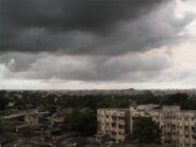
s. The nation is largely subject to four seasons: winter (January and February), summer (March to May), a monsoon (rainy) season (June to September), and a post-monsoon period (October to December).
India's geography
and geology
are climatically pivotal: the Thar Desert
in the northwest and the Himalayas
in the north work in tandem to effect a culturally
and economically
break-all monsoonal regime. As Earth's highest and most massive mountain range, the Himalayan system bars the influx of frigid katabatic wind
s from the icy Tibetan Plateau
and northerly Central Asia
. Most of North India
is thus kept warm or is only mildly chilly or cold during winter; the same thermal dam keeps most regions in India hot in summer.
Though the Tropic of Cancer
—the boundary between the tropics and subtropics—passes through the middle of India, the bulk of the country can be regarded as climatically tropical. As in much of the tropics, monsoonal and other weather patterns in India can be wildly unstable: epochal droughts, floods, cyclones, and other natural disasters are sporadic, but have displaced or ended millions of human lives. There is widespread scientific consensus that South Asia
is likely to see such climatic events, along with their aleatory unpredictabilty, to change in frequency and are likely to increase in severity. Ongoing and future vegetative changes and current sea level rise
s and the attendant inundation of India's low-lying coastal areas are other impacts, current or predicted, that are attributable to global warming
.
During the Triassic
period of some 251–199.6 Ma, the Indian subcontinent was part of a vast supercontinent
known as Pangaea
. Despite its position within a high-latitude belt at 55–75° S—as opposed to its current position between 5 and 35° N, latitudes now occupied by Greenland
and parts of the Antarctic Peninsula
—India likely experienced a humid temperate climate with warm and frost-free weather, though with well-defined seasons. India later merged into the southern supercontinent Gondwana
, a process beginning some 550–500 Ma. During the Late Paleozoic
, Gondwana extended from a point at or near the South Pole
to near the equator, where the Indian craton (stable continental crust
) was positioned, resulting in a mild climate favourable to hosting high-biomass
ecosystems. This is underscored by India's vast coal reserves—much of it from the late Paleozoic sedimentary sequence—the fourth-largest reserves in the world. During the Mesozoic
, the world, including India, was considerably warmer than today. With the coming of the Carboniferous
, global cooling
stoked extensive glaciation, which spread northwards from South Africa
towards India; this cool period lasted well into the Permian
.
Tectonic movement
by the Indian Plate caused it to pass over a geologic hotspot
—the Réunion hotspot
—now occupied by the volcanic island of Réunion
. This resulted in a massive flood basalt
event that laid down the Deccan Traps
some 60–68 Ma, at the end of the Cretaceous
period. This may have contributed to the global Cretaceous-Tertiary (K-T) extinction event
, which caused India to experience significantly reduced insolation
. Elevated atmospheric levels of sulphur gases formedaerosol
s such as sulfur dioxide
and sulfuric acid
, similar to those found in the atmosphere of Venus
; these precipitated as acid rain
. Elevated carbon dioxide
emissions also contributed to the greenhouse effect
, causing warmer weather
that lasted long after the atmospheric shroud of dust and aerosols had cleared. Further climatic changes 20 million years ago, long after India had crashed into the Laurasia
n landmass, were severe enough to cause the extinction of many endemic Indian forms. The formation of the Himalayas resulted in blockage of frigid Central Asian air, preventing it from reaching India; this made its climate significantly warmer and more tropical in character than it would otherwise have been.
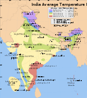
India is home to an extraordinary variety of climatic regions, ranging from tropical in the south to temperate and alpine in the Himalayan north, where elevated regions receive sustained winter snowfall. The nation's climate is strongly influenced by the Himalayas and the Thar Desert. The Himalayas, along with the Hindu Kush
mountains in Pakistan, prevent cold Central Asian katabatic winds from blowing in, keeping the bulk of the Indian subcontinent warmer than most locations at similar latitude
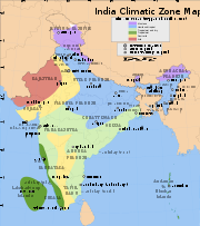
s. Simultaneously, the Thar Desert plays a role in attracting moisture-laden southwest summer monsoon winds that, between June and October, provide the majority of India's rainfall. Four major climatic groupings predominate, into which fall seven climatic zones that, as designated by experts, are defined on the basis of such traits as temperature and precipitation. Groupings are assigned codes (see chart) according to the Köppen climate classification system.
—that covers a strip of southwestern lowlands abutting the Malabar Coast
, the Western Ghats
, and southern Assam. India's two island territories, Lakshadweep and the Andaman and Nicobar Islands, are also subject to this climate. Characterised by moderate to high year-round temperatures, even in the foothills, its rainfall is seasonal but heavy—typically above 2000 mm (79 in) per year. Most rainfall occurs between May and November; this moisture is enough to sustain lush forests and other vegetation for the rest of the mainly dry year. December to March are the driest months, when days with precipitation are rare. The heavy monsoon rains are responsible for the exceptionally biodiverse tropical wet forests in parts of these regions. In India a tropical wet and dry climate
is more common. Noticeably drier than areas with a tropical monsoon climate, it prevails over most of inland peninsular India except for a semi arid rain shadow east of the Western Ghats. Winter and early summer are long and dry periods with temperatures averaging above 18 °C (64 °F). Summer is exceedingly hot; temperatures in low-lying areas may exceed 50 °C (122 °F) during May, leading to heat waves that can each kill hundreds of Indians.
The rainy season lasts from June to September; annual rainfall averages between 750 – across the region. Once the dry northeast monsoon begins in September, most precipitation in India falls on Tamil Nadu, leaving other states comparatively dry. The state's normal annual rainfall is about 945 mm (37.2 in), of which 48% is delivered by the northeast monsoon and 32% by the southwest monsoon. Since the state is entirely dependent on rains for recharging its water resources, monsoon failures lead to acute water scarcity and severe drought. Tamil Nadu is classified into seven agro-climatic zones: northeast, northwest, west, southern, high rainfall, high altitude hilly, and the Kaveri River Delta, the last being the most fertile agricultural zone. The table below shows the maximum and minimum temperatures that the state experiences in the plains and hills. The Ganges Delta lies mostly in the tropical wet climate zone: it receives between 1500 to 2000 mm (59.1 to 78.7 in) of rainfall each year in the western part, and 2000 to 3000 mm (78.7 to 118.1 in) in the eastern part. The coolest month of the year, on average, is January; April and May are the warmest months. Average temperatures in January range from 14 to 25 °C (57.2 to 77 °F), and average temperatures in April range from 25 to 35 °C (77 to 95 °F). July is on average the wettest month: over 330 mm (13 in) of rain falls on the delta.
climate dominates regions where the rate of moisture loss through evapotranspiration
exceeds that from precipitation; it is subdivided into three climatic subtypes. The first, a tropical semi-arid steppe climate, predominates over a long stretch of land south of Tropic of Cancer and east of the Western Ghats and the Cardamom Hills
. The region, which includes Karnataka, inland Tamil Nadu, western Andhra Pradesh, and central Maharashtra, gets between 400 – annually. It is drought-prone, as it tends to have less reliable rainfall due to sporadic lateness or failure of the southwest monsoon. Karnataka is divided into three zones — coastal, north interior and south interior. Of these, the coastal zone receives the heaviest rainfall with an average rainfall of about 3,638.5 mm (143 in) per annum, far in excess of the state average of 1,139 mm (45 in). In contrast to norm, Agumbe in the Shivamogga district receives the second highest annual rainfall in India. North of the Krishna River
, the summer monsoon is responsible for most rainfall; to the south, significant post-monsoon rainfall also occurs in October and November. In December, the coldest month, temperatures still average around 20 –. The months between March to May are hot and dry; mean monthly temperatures hover around 32 °C, with 320 millimetres (13 in)precipitation. Hence, without artificial irrigation, this region is not suitable for permanent agriculture.
 Most of western Rajasthan experiences an arid climatic regime. Cloudburst
s are responsible for virtually all of the region's annual precipitation, which totals less than 300 millimetres (11.8 in). Such bursts happen when monsoon winds sweep into the region during July, August, and September. Such rainfall is highly erratic; regions experiencing rainfall one year may not see precipitation for the next couple of years or so. Atmospheric moisture is largely prevented from precipitating due to continuous downdrafts
and other factors. The summer months of May and June are exceptionally hot; mean monthly temperatures in the region hover around 35 °C (95 °F), with daily maxima occasionally topping 50 °C (122 °F). During winters, temperatures in some areas can drop below freezing due to waves of cold air from Central Asia. There is a large diurnal range of about 14 C-change during summer; this widens by several degrees during winter.
To the west, in Gujarat, diverse climate conditions obtain. The winters are mild, pleasant, and dry with average daytime temperatures around 29 °C (84 °F) and nights around 12 °C (54 °F) with virtually full sun and clear nights. Summers are hot and dry with daytime temperatures around 41 °C (106 °F) and nights no lower than 29 °C (84 °F). In the weeks before the monsoon temperatures are similar to the above, but high humidity makes the air more uncomfortable. Relief comes with the monsoon. Temperatures are around 35 °C (95 °F) but humidity is very high; nights are around 27 °C (81 °F). Most of the rainfall occurs in this season, and the rain can cause severe floods. The sun is often occluded during the monsoon season.
East of the Thar Desert, the Punjab-Haryana-Kathiawar region experiences a tropical and sub-tropical steppe climate. Haryana's climate resembles other states of the northern plains: extreme summer heat of up to 50 °C and winter cold as low as 1 °C. May and June are hottest; December and January are coldest. Rainfall is varied, with the Shivalik Hills region being the wettest and the Aravali Hills region being the driest. About 80% of the rainfall occurs in the monsoon season of July–September, which can cause flooding. The Punjabi climate is also governed by extremes of hot and cold. Areas near the Himalayan foothills receive heavy rainfall whereas those eloigned from them are hot and dry. Punjab’s three-season climate sees summer months that spans from mid-April to the end of June. Temperatures typically range from–2 °C to 40 °C, but can reach 47 °C (117 °F) in summer and –4 °C in winter. The zone, a transitional climatic region separating tropical desert from humid sub-tropical savanna and forests, experiences temperatures that are less extreme than those of the desert. Average annual rainfall is 300 –, but is very unreliable; as in much of the rest of India, the southwest monsoon accounts for most precipitation. Daily summer temperature maxima rise to around 40 °C (104 °F); this results in natural vegetation typically comprises short, coarse grasses.
. Though they experience hot summers, temperatures during the coldest months may fall as low as 0 °C (32 °F). Due to ample monsoon rains, India has only one subtype of this climate under the Köppen system: Cwa. In most of this region, there is very little precipitation during the winter, owing to powerful anticyclonic and katabatic (downward-flowing) winds from Central Asia.
Humid subtropical regions are subject to pronounced dry winters. Winter rainfall—and occasionally snowfall—is associated with large storm systems such as "Nor'westers" and "Western disturbances"; the latter are steered by westerlies
towards the Himalayas. Most summer rainfall occurs during powerful thunderstorms associated with the southwest summer monsoon; occasional tropical cyclones also contribute. Annual rainfall ranges from less than 1000 millimetres (39 in) in the west to over 2500 millimetres (98 in) in parts of the northeast. As most of this region is far from the ocean, the wide temperature swings more characteristic of a continental climate
predominate; the swings are wider than in those in tropical wet regions, ranging from 24 °C (75 °F) in north-central India to 27 °C (81 °F) in the east.
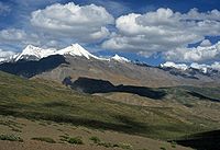
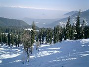
 India's northernmost areas are subject to a montane, or alpine, climate. In the Himalayas, the rate at which an air mass's temperature falls per kilometre (3,281 ft) of altitude gained (the dry adiabatic lapse rate
) is 9.8 °C/km. In terms of environmental lapse rate, ambient temperatures fall by 6.5 C-change for every 1000 metres (3,281 ft) rise in altitude. Thus, climates ranging from nearly tropical in the foothills to tundra above the snow line
can coexist within several hundred metres of each other. Sharp temperature contrasts between sunny and shady slopes, high diurnal temperature variability, temperature inversions, and altitude-dependent variability in rainfall are also common. The northern side of the western Himalayas, also known as the trans-Himalayan belt, is a region of barren, arid, frigid, and wind-blown wastelands. Most precipitation occurs as snowfall during the late winter and spring months.
Areas south of the Himalayas are largely protected from cold winter winds coming in from the Asian interior. The leeward side (northern face) of the mountains receives less rain while the southern slopes, well-exposed to the monsoon, get heavy rainfall. Areas situated at elevations of 1,070–2,290 metres (3,510–7,510 ft) receive the heaviest rainfall, which decreases rapidly at elevations above 2290 metres (7,513 ft). The Himalayas experience their heaviest snowfall between December and February and at elevations above 1500 metres (4,921 ft). Snowfall increases with elevation by up to several dozen millimetres per 100 metre (~2 in; 330 ft) increase. Elevations above 5000 metres (16,404 ft) never experience rain; all precipitation falls as snow.
 The India Meteorological Department
(IMD) designates four official seasons:
The Himalayan states, being more temperate, experience an additional two seasons: autumn and spring. Traditionally, Indians note six seasons, each about two months long. These are the spring (), summer (grīṣma), monsoon season (varṣā), early autumn (śarada), late autumn (hemanta), and winter (śiśira). These are based on the astronomical division of the twelve months into six parts. The ancient Hindu calendar
also reflects these seasons in its arrangement of months.
 In northwestern India, virtually cloudless conditions prevail in October and November, resulting in wide diurnal temperature swings; as in much of the Deccan Plateau, they register at 16 –. However, from March to May, "western disturbances" bring heavy bursts of rain and snow. These extra-tropical low-pressure systems
originate in the eastern Mediterranean Sea. They are carried towards India by the subtropical westerlies
, which are the prevailing winds blowing at North India's range of latitude. Once their passage is hindered by the Himalayas, they are unable to proceed further, and they release significant precipitation over the southern Himalayas.
There is a huge variation in the climatic conditions of Himachal Pradesh due to variation in altitude (450-6500 metres). The climate varies from hot and sub-humid tropical (450-900 metres) in the southern low tracts, warm and temperate (900-1800 metres), cool and temperate (1900-2400 metres) and cold glacial and alpine (2400-4800 metres) in the northern and eastern high elevated mountain ranges. By October, nights and mornings are very cold. Snowfall at elevations of nearly 3000 m is about 3 m and lasts from December start to March end. Elevations above 4500 m support perpetual snow. The spring season starts from mid February to mid April. The weather is pleasant and comfortable in the season. The rainy season starts at the end of the month of June. The landscape lushes green and fresh. During the season streams and natural springs are replenished. The heavy rains in July and August cause a lot of damage resulting into erosion, floods and landslides. Out of all the state districts, Dharamsala receives the highest rainfall, nearly about 3400 mm (134 in). Spiti is the driest area of the state, where annual rainfall is below 50 mm. The three Himalayan states (Jammu and Kashmir in the extreme north, Himachal Pradesh, and Uttarakhand) experience heavy snowfall; in Jammu and Kashmir, blizzard
s occur regularly, disrupting travel and other activities.
The rest of North India, including the Indo-Gangetic Plain
, almost never receives snow. Temperatures in the plains occasionally fall below freezing, though never for more one or two days. Winter highs in Delhi range from 16 to 21 °C (60.8 to 69.8 F). Nighttime temperatures average 2 –. In the plains of Punjab, lows can fall below freezing, dropping to around -6 °C in Amritsar
. Frost sometimes occurs, but the hallmark of the season is the notorious fog, which frequently disrupts daily life; fog grows thick enough to hinder visibility and disrupt air travel 15–20 days annually. In Bihar in middle of the Ganges plain, hot weather sets in and the summer lasts until the middle of June. The highest temperature is often registered in May which is the hottest time. Like the rest of the north, Bihar also experiences dust-storms, thunderstorms and dust raising winds during the hot season. Dust storms having a velocity of 48 – are most frequent in May and with second maximum in April and June. The hot winds (loo) of Bihar
plains blow during April and May with an average velocity of 8 –. These hot winds greatly affects human comfort during this season. Rain follows. The rainy season begins in June. The rainiest months are July and August. The rains are the gifts of the southwest monsoon. There are in Bihar three distinct areas where rainfall exceeds 1800 mm (71 in). Two of them are in the northern and northwestern portions of the state; the third lies in the area around Netarhat
. The southwest monsoon normally withdraws from Bihar in the first week of October. Eastern India's climate is much milder, experiencing moderately warm days and cool nights. Highs range from 23 °C (73 °F) in Patna
to 26 °C (79 °F) in Kolkata
(Calcutta); lows average from 8 °C (46 °F) in Patna to 14 °C (57 °F) in Kolkata.
Frigid winds from the Himalayas can depress temperatures near the Brahmaputra River
. The Himalayas have a profound effect on the climate of the Indian subcontinent and the Tibetan plateau by preventing frigid and dry Arctic winds from blowing south into the subcontinent, which keeps South Asia much warmer than corresponding temperate regions in the other continents. It also forms a barrier for the monsoon
winds, keeping them from traveling northwards, and causing heavy rainfall in the Terai
region instead. The Himalayas are indeed believed to play an important role in the formation of Central Asia
n deserts such as the Taklamakan
and Gobi. The mountain ranges prevent western winter disturbances in Iran from traveling further east, resulting in much snow in Kashmir and rainfall for parts of Punjab
and northern India. Despite being a barrier to the cold northernly winter winds, the Brahmaputra valley receives part of the frigid winds, thus lowering the temperature in Northeast India and Bangladesh. The Himalayas, which are often called "The Roof of the World", contain the greatest area of glaciers and permafrost outside of the poles. Ten of Asia’s largest rivers flow from there. The two Himalayan states in the east, Sikkim and Arunachal Pradesh, receive substantial snowfall. The extreme north of West Bengal
centred around Darjeeling experiences snowfall, but only rarely. Parts of Uttar Pradesh are also affected by snowfall of several meters in places. Rainfall in that state ranges from 1000 – in the east to 600 – in the west.
In South India
, particularly the hinterlands of Maharashtra, Madhya Pradesh
, parts of Karnataka, and Andhra Pradesh, somewhat cooler weather prevails. Minimum temperatures in western Maharashtra, Madhya Pradesh and Chhattisgarh
hover around 10 °C (50 °F); in the southern Deccan Plateau, they reach 16 °C (61 °F). Coastal areas—especially those near the Coromandel Coast
and adjacent low-elevation interior tracts—are warm, with daily high temperatures of 30 °C (86 °F) and lows of around 21 °C (70 °F). The Western Ghats, including the Nilgiri Range
, are exceptional; lows there can fall below freezing. This compares with a range of 12 – on the Malabar Coast; there, as is the case for other coastal areas, the Indian Ocean exerts a strong moderating influence on weather. The region averages 800 millimetres (31.5 in) per year, most of which falls between October and December. The topography of the Bay of Bengal and the staggered weather pattern prevalent during the season favours the northeast monsoon, which has a tendency to cause cyclones and hurricanes rather than steady precipitation. As a result the coast is hit by what can mildly be termed as inclement weather almost every year between October and January.
 Summer in northwestern India lasts from April to July, and in the rest of the country from March to June. The temperatures in the north rise as the vertical rays of the Sun reach the Tropic of Cancer. The hottest month for the western and southern regions of the country is April; for most of North India, it is May. Temperatures of 50 °C (122 °F) and higher have been recorded in parts of India during this season. In cooler regions of North India, immense pre-monsoon squall
-line thunderstorms, known locally as "Nor'westers", commonly drop large hailstones. In Himachal Pradesh, Summer lasts from mid April till the end of June and most parts become very hot (except in alpine
zone which experience mild summer) with the average temperature ranging from 28 °C (82 °F) to 32 °C (90 °F). Winter lasts from late November till mid March. Snowfall is generally common in alpine tracts that are above 2200 metres (7,218 ft), especially those in the higher- and trans-Himalayan regions. Near the coast the temperature hovers around 36 °C (97 °F), and the proximity of the sea increases the level of humidity. In southern India, the temperatures are higher on the east coast by a few degrees compared to the west coast.
By May, most of the Indian interior experiences mean temperatures over 32 °C (90 °F), while maximum temperatures often exceed 40 °C (104 °F). In the hot months of April and May, western disturbances, with their cooling influence, may still arrive, but rapidly diminish in frequency as summer progresses. Notably, a higher frequency of such disturbances in April correlates with a delayed monsoon onset (thus extending summer) in northwest India. In eastern India, monsoon onset dates have been steadily advancing over the past several decades, resulting in shorter summers there.
Altitude affects the temperature to a large extent, with higher parts of the Deccan Plateau
and other areas being relatively cooler. Hill station
s, such as Ootacamund
("Ooty") in the Western Ghats and Kalimpong in the eastern Himalayas, with average maximum temperatures of around 25 °C (77 °F), offer some respite from the heat. At lower elevations, in parts of northern and western India, a strong, hot, and dry wind known as the Loo
blows in from the west during the daytime; with very high temperatures, in some cases up to around 45 °C (113 °F); it can cause fatal cases of sunstroke
. Tornado
es may also occur, concentrated in a corridor stretching from northeastern India towards Pakistan. They are rare, however; only several dozen have been reported since 1835.
s originating from a high-pressure mass centered over the southern Indian Ocean, the monsoonal torrents supply over 80% of India's annual rainfall. Attracted by a low-pressure region centered over South Asia, the mass spawns surface winds that ferry humid air into India from the southwest. These inflows ultimately result from a northward shift of the local jet stream, which itself results from rising summer temperatures over Tibet
and the Indian subcontinent. The void left by the jet stream, which switches from a route just south of the Himalayas to one tracking north of Tibet, then attracts warm, humid air.
The main factor behind this shift is the high summer temperature difference between Central Asia and the Indian Ocean. This is accompanied by a seasonal excursion of the normally equatorial intertropical convergence zone
(ITCZ), a low-pressure belt of highly unstable weather, northward towards India. This system intensified to its present strength as a result of the Tibetan Plateau
's uplift
, which accompanied the Eocene
–Oligocene
transition event, a major episode of global cooling and aridification
which occurred 34–49 Ma.
The southwest monsoon arrives in two branches: the Bay of Bengal
branch and the Arabian Sea
branch. The latter extends towards a low-pressure area over the Thar Desert and is roughly three times stronger than the Bay of Bengal branch. The monsoon typically breaks over Indian territory by around 25 May, when it lashes the Andaman and Nicobar Islands in the Bay of Bengal. It strikes the Indian mainland around 1 June near the Malabar Coast
of Kerala. By 9 June, it reaches Mumbai; it appears over Delhi by 29 June. The Bay of Bengal branch, which initially tracks the Coromandal Coast northeast from Cape Comorin to Orissa, swerves to the northwest towards the Indo-Gangetic Plain
. The Arabian Sea branch moves northeast towards the Himalayas. By the first week of July, the entire country experiences monsoon rain; on average, South India receives more rainfall than North India. However, Northeast India
receives the most precipitation. Monsoon clouds begin retreating from North India by the end of August; it withdraws from Mumbai by 5 October. As India further cools during September, the southwest monsoon weakens. By the end of November, it has left the country.
 Monsoon rains impact the health of the Indian economy
; as Indian agriculture
employs 600 million people and composes 20% of the national GDP
, good monsoons correlate with a booming economy. Weak or failed monsoons (droughts) result in widespread agricultural losses and substantially hinder overall economic growth. Yet such rains reduce temperatures and can replenish groundwater tables, rivers, and lakes.
(IMD) and other sources refers to this period as a fourth ("post-monsoon") season, other sources designate only three seasons. Depending on location, this period lasts from October to November, after the southwest monsoon has peaked. Less and less precipitation falls, and vegetation begins to dry out. In most parts of India, this period marks the transition from wet to dry seasonal conditions. Average daily maximum temperatures range between 28 and 34 °C (82.4 and 93.2 F).
The northeast monsoon, which begins in September, lasts through the post-monsoon seasons, and only ends in March. It carries winds that have already lost their moisture while crossing central Asia and the vast rain shadow region lying north of the Himalayas. They cross India diagonally from northeast to southwest. However, the large indentation made by the Bay of Bengal into India's eastern coast means that the flows are humidified before reaching Cape Comorin and rest of Tamil Nadu, meaning that the state, and also some parts of Kerala, experience significant precipitation in the post-monsoon and winter periods. However, parts of West Bengal, Orissa, Andhra Pradesh, Karnataka
and Northeast India also receive minor precipitation from the northeast monsoon.
tyle="vertical-align: top;" align="right"|
rock formations, which are susceptible to slippages. Rising population and development pressures, particularly from logging and tourism, cause deforestation. The result, denuded hillsides, exacerbates the severity of landslides, since tree cover impedes the downhill flow of water. Parts of the Western Ghats also suffer from low-intensity landslides. Avalanches occur in Kashmir, Himachal Pradesh, and Sikkim.
Floods are the most common natural disaster in India. The heavy southwest monsoon rains cause the Brahmaputra
and other rivers to distend their banks, often flooding surrounding areas. Though they provide rice paddy farmers with a largely dependable source of natural irrigation and fertilisation, the floods can kill thousands and displace millions. Excess, erratic, or untimely monsoon rainfall may also wash away or otherwise ruin crops. Almost all of India is flood-prone, and extreme precipitation events, such as flash floods and torrential rains, have become increasingly common in central India over the past several decades, coinciding with rising temperatures. Mean annual precipitation totals have remained steady due to the declining frequency of weather systems that generate moderate amounts of rain.
 Tropical cyclone
s, which are severe storms spun off from the Intertropical Convergence Zone
, may affect thousands of Indians living in coastal regions. Tropical cyclogenesis
is particularly common in the northern reaches of the Indian Ocean in and around the Bay of Bengal. Cyclones bring with them heavy rains, storm surge
s, and winds that often cut affected areas off from relief and supplies. In the North Indian Ocean Basin, the cyclone season runs from April to December, with peak activity between May and November. Each year, an average of eight storms with sustained wind speeds greater than 63 km/h (39 mph) form; of these, two strengthen into true tropical cyclones, which have sustained gusts greater than 117 km/h (72.7 mph). On average, a major (Category 3
or higher) cyclone develops every other year.
During summer, the Bay of Bengal
is subject to intense heating, giving rise to humid and unstable air masses that morph into cyclones. The 1737 Calcutta cyclone, the 1970 Bhola cyclone
, and the 1991 Bangladesh cyclone
rank among the most powerful cyclones to strike India, devastating the coasts of eastern India and neighboring Bangladesh. Widespread death and property destruction are reported every year in the exposed coastal states of West Bengal, Orissa, Andhra Pradesh, and Tamil Nadu. India's western coast, bordering the more placid Arabian Sea, experiences cyclones only rarely; these mainly strike Gujarat and, less frequently, Kerala.
Cyclone 05B
, a supercyclone that struck Orissa on 29 October 1999, was the deadliest in more than a quarter-century. With peak winds of 160 miles per hour (257 km/h), it was the equivalent of a Category 5 hurricane
. Almost two million people were left homeless;another 20 million people lives were disrupted by the cyclone. Officially, 9,803 people died from the storm; unofficial estimates place the death toll at over 10,000.
 Indian agriculture is heavily dependent on the monsoon as a source of water. In some parts of India, the failure of the monsoons result in water shortages, resulting in below-average crop yields. This is particularly true of major drought-prone regions such as southern and eastern Maharashtra, northern Karnataka, Andhra Pradesh, Orissa, Gujarat, and Rajasthan. In the past, droughts have periodically led to major Indian famines
. These include the Bengal famine of 1770
, in which up to one third of the population in affected areas died; the 1876–1877 famine, in which over five million people died; the 1899 famine, in which over 4.5 million died; and the Bengal famine of 1943
, in which over five million died from starvation and famine-related illnesses.
All such episodes of severe drought correlate with El Niño-Southern Oscillation
(ENSO) events. El Niño-related droughts have also been implicated in periodic declines in Indian agricultural output. Nevertheless, ENSO events that have coincided with abnormally high sea surfaces temperatures in the Indian Ocean—in one instance during 1997 and 1998 by up to 3 °C (37 °F)—have resulted in increased oceanic evaporation, resulting in unusually wet weather across India. Such anomalies have occurred during a sustained warm spell that began in the 1990s. A contrasting phenomenon is that, instead of the usual high pressure air mass over the southern Indian Ocean, an ENSO-related oceanic low pressure convergence center forms; it then continually pulls dry air from Central Asia, desiccating India during what should have been the humid summer monsoon season. This reversed air flow causes India's droughts. The extent that an ENSO event raises sea surface temperature
s in the central Pacific Ocean influences the extent of drought.
 India's lowest recorded temperature was -45 °C in Dras
, Ladakh, in eastern Jammu and Kashmir; the reading was taken with non-standard equipment. Figures as low as -30.6 °C have been taken in Leh, further east in Ladakh. However, temperatures on the disputed but Indian-controlled Siachen Glacier
near Bilafond La
(5450 metres (17,881 ft)) and Sia La
(5589 metres (18,337 ft)) have fallen below -55 °C, while blizzards bring wind speeds in excess of 250 km/h (155 mph), or hurricane-force winds ranking at 12—the maximum—on the Beaufort scale
. These conditions, not hostile actions, caused more than 97% of the roughly 15,000 casualties suffered among Indian and Pakistani soldiers during the Siachen conflict
. The highest reliable temperature reading was 50.6 °C (123.1 °F) in Alwar, Rajasthan in 1955. The India Meteorological Department doubts the validity of 55 °C (131 °F) readings reported in Orissa during 2005.
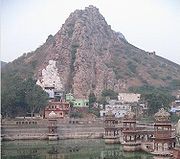
The average annual precipitation of 11871 millimetres (467 in) in the village of Mawsynram
, in the hilly northeastern state of Meghalaya, is the highest recorded in Asia, and possibly on Earth. The village, which sits at an elevation of 1401 metres (4,596 ft), benefits from its proximity to both the Himalayas and the Bay of Bengal. However, since the town of Cherrapunji
, 5 kilometres (3.1 mi) to the east, is the nearest town to host a meteorological office—none has ever existed in Mawsynram—it is officially credited as being the world's wettest place. In recent years the Cherrapunji-Mawsynram region has averaged between 9296 and 10820 mm (366 and 426 in) of rain annually, though Cherrapunji has had at least one period of daily rainfall that lasted almost two years. India's highest recorded one-day rainfall total occurred on 26 July 2005, when Mumbai received more than 650 mm (26 in); the massive flooding that resulted killed over 900 people.
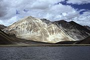
Remote regions of Jammu and Kashmir such as Baramulla district in the east and the Pir Panjal Range
in the southeast experience exceptionally heavy snowfall. In southern areas around Jammu the climate is typically monsoonal, though the region is sufficiently far west to average 40 – of rain monthly from January and March. In the hot season, Jammu city is very hot and can reach up to 40 °C (104 °F) while in July and August, very heavy—though erratic—rainfall occurs with monthly extremes of up to 650 millimetres (25.6 in). Rainfall declines in September; by October conditions are extremely dry, with temperatures of around 29 °C (84 °F). Across from the Pir Panjal range, the South Asian monsoon is no longer a factor and most precipitation falls in the spring from southwestern cloudbands. Because of its closeness to the Arabian Sea, Srinagar receives as much as 25 inches (635 mm) of rain from this source, with the wettest months being March to May with around 85 mm (3.3 inches) per month.
North of the main Himalaya Range, even the southwestern cloudbands break up or founder; hence the climate of Ladakh and the Zanskars is extremely dry and cold. Annual precipitation is only around 100 mm (4 inches) per year and humidity is very low. This region is almost entirely above 3,000 metres (9,750 ft) above sea level; thus winters are extremely cold. In the Zanskars, the average January temperature is −20 °C with extremes as low as −40 °C. All rivers freeze over; locals cross unbridged rivers in winter because summer glacier melt deepens the waters and inhibits fording. Summer in Ladakh and the Zanskars are a pleasantly warm 20 °C (68 °F), but the low humidity and thin air can render nights cold. Kashmir's highest recorded monthly snowfall occurred in February 1967, when 8.4 metres (27.6 ft) fell in Gulmarg
, though the IMD has recorded snowdrifts up to 12 metres (39.4 ft)in several Kashmiri districts. In February 2005, more than 200 people died when, in four days, a western disturbance brought up to 2 metres (6.6 ft) of snowfall to parts of the state.
 Current sea level rise
, increased cyclonic activity, increased ambient temperatures, and increasingly fickle precipitation patterns are effects of global warming
that have affected or are projected to impact India. Thousands of people have been displaced by ongoing sea level rises that have submerged low-lying islands in the Sundarbans
. Temperature rises on the Tibetan Plateau are causing Himalayan glaciers to retreat
, threatening the flow rate
of the Ganges, Brahmaputra, Yamuna
, and other major rivers; the livelihoods of hundreds of thousands of farmers depend on these rivers. A 2007 World Wide Fund for Nature
(WWF) report states that the Indus River
may run dry for the same reason.
Severe landslides and floods are projected to become increasingly common in such states as Assam. Ecological disasters, such as a 1998 coral bleaching
event that killed off more than 70% of corals in the reef ecosystems off Lakshadweep and the Andamans and was brought on by elevated ocean temperatures tied to global warming, are also projected to become increasingly common. Meghalaya and other northeastern states are also concerned that rising sea levels will submerge much of Bangladesh and spawn a refugee crisis. If severe climate changes occurs, Bangladesh and parts of India that border it may lose vast tracts of coastal land.
The Indira Gandhi Institute of Development Research
has reported that, if the predictions relating to global warming made by the Intergovernmental Panel on Climate Change
come to fruition, climate-related factors could cause India's GDP to decline by up to 9%. Contributing to this would be shifting growing seasons for major crops such as rice, production of which could fall by 40%. Around seven million people are projected to be displaced due to, among other factors, submersion of parts of Mumbai and Chennai if global temperatures were to rise by a mere 2 C-change. Such shifts are not new. Earlier in the Holocene
epoch (4,800–6,300 years ago), parts of what is now the Thar Desert were wet enough to support perennial lakes; researchers have proposed that this was due to much higher winter precipitation, which coincided with stronger monsoons. Kashmir's erstwhile subtropical climate dramatically cooled 2.6–3.7 Ma and experienced prolonged cold spells starting 600,000 years ago.
 Thick haze and smoke originating from burning biomass in northwestern India and air pollution from large industrial cities in northern India often concentrate over the Ganges Basin. Prevailing westerlies carry aerosols along the southern margins of the sheer-faced Tibetan Plateau towards eastern India and the Bay of Bengal
. Dust and black carbon
, which are blown towards higher altitudes by winds at the southern margins of the Himalayas, can absorb shortwave radiation and heat the air over the Tibetan Plateau. The net atmospheric heating due to aerosol absorption causes the air to warm and convect
upwards, increasing the concentration of moisture in the mid-troposphere
and providing positive feedback that stimulates further heating of aerosols.
General overview
Maps, imagery, and statistics
Forecasts
----
Köppen climate classification
The Köppen climate classification is one of the most widely used climate classification systems. It was first published by Crimea German climatologist Wladimir Köppen in 1884, with several later modifications by Köppen himself, notably in 1918 and 1936...
, the climate of India resolves into six major climatic subtypes; their influences give rise to desert in the west, alpine tundra
Alpine tundra
Alpine tundra is a natural region that does not contain trees because it is at high altitude. Alpine tundra is distinguished from arctic tundra, because alpine soils are generally better drained than arctic soils...
and glaciers in the north, humid tropical regions supporting rain forests in the southwest, and Indian Ocean
Indian Ocean
The Indian Ocean is the third largest of the world's oceanic divisions, covering approximately 20% of the water on the Earth's surface. It is bounded on the north by the Indian Subcontinent and Arabian Peninsula ; on the west by eastern Africa; on the east by Indochina, the Sunda Islands, and...
island territories that flank the Indian subcontinent
Indian subcontinent
The Indian subcontinent, also Indian Subcontinent, Indo-Pak Subcontinent or South Asian Subcontinent is a region of the Asian continent on the Indian tectonic plate from the Hindu Kush or Hindu Koh, Himalayas and including the Kuen Lun and Karakoram ranges, forming a land mass which extends...
. Regions have starkly different—yet tightly clustered—microclimate
Microclimate
A microclimate is a local atmospheric zone where the climate differs from the surrounding area. The term may refer to areas as small as a few square feet or as large as many square miles...
s. The nation is largely subject to four seasons: winter (January and February), summer (March to May), a monsoon (rainy) season (June to September), and a post-monsoon period (October to December).
India's geography
Geography of India
The geography of India describes the physical features of India, a country in South Asia, that lies entirely on the Indian Plate in the northern portion of the Indo-Australian Plate. The country lies to the north of the equator between 8°4' and 37°6' north latitude and 68°7' and 97°25' east...
and geology
Geology of India
The geology of India started with the geological evolution of rest of the Earth i.e. 4.57 Ga . India has a diverse geology. Different regions in India contain rocks of all types belonging to different geologic periods. Some of the rocks are badly deformed and transmuted while others are recently...
are climatically pivotal: the Thar Desert
Thar Desert
The Thar Desert |Punjab]] province. The Cholistan Desert adjoins the Thar desert spreading into Pakistani Punjab province.-Location and description:...
in the northwest and the Himalayas
Himalayas
The Himalaya Range or Himalaya Mountains Sanskrit: Devanagari: हिमालय, literally "abode of snow"), usually called the Himalayas or Himalaya for short, is a mountain range in Asia, separating the Indian subcontinent from the Tibetan Plateau...
in the north work in tandem to effect a culturally
Culture of India
India's languages, religions, dance, music, architecture, food and customs differ from place to place within the country, but nevertheless possess a commonality....
and economically
Economy of India
The Economy of India is the ninth largest in the world by nominal GDP and the fourth largest by purchasing power parity . The country is a part of the G-20 major economies and the BRICS, in addition to being partners of the ASEAN. India has a per capita GDP of $3,608 as per 2010 figures, making it...
break-all monsoonal regime. As Earth's highest and most massive mountain range, the Himalayan system bars the influx of frigid katabatic wind
Katabatic wind
A katabatic wind, from the Greek word katabatikos meaning "going downhill", is the technical name for a drainage wind, a wind that carries high density air from a higher elevation down a slope under the force of gravity. Such winds are sometimes also called fall winds...
s from the icy Tibetan Plateau
Tibetan Plateau
The Tibetan Plateau , also known as the Qinghai–Tibetan Plateau is a vast, elevated plateau in Central Asia covering most of the Tibet Autonomous Region and Qinghai, in addition to smaller portions of western Sichuan, southwestern Gansu, and northern Yunnan in Western China and Ladakh in...
and northerly Central Asia
Central Asia
Central Asia is a core region of the Asian continent from the Caspian Sea in the west, China in the east, Afghanistan in the south, and Russia in the north...
. Most of North India
North India
North India, known natively as Uttar Bhārat or Shumālī Hindustān , is a loosely defined region in the northern part of India. The exact meaning of the term varies by usage...
is thus kept warm or is only mildly chilly or cold during winter; the same thermal dam keeps most regions in India hot in summer.
Though the Tropic of Cancer
Tropic of Cancer
The Tropic of Cancer, also referred to as the Northern tropic, is the circle of latitude on the Earth that marks the most northerly position at which the Sun may appear directly overhead at its zenith...
—the boundary between the tropics and subtropics—passes through the middle of India, the bulk of the country can be regarded as climatically tropical. As in much of the tropics, monsoonal and other weather patterns in India can be wildly unstable: epochal droughts, floods, cyclones, and other natural disasters are sporadic, but have displaced or ended millions of human lives. There is widespread scientific consensus that South Asia
South Asia
South Asia, also known as Southern Asia, is the southern region of the Asian continent, which comprises the sub-Himalayan countries and, for some authorities , also includes the adjoining countries to the west and the east...
is likely to see such climatic events, along with their aleatory unpredictabilty, to change in frequency and are likely to increase in severity. Ongoing and future vegetative changes and current sea level rise
Current sea level rise
Current sea level rise potentially impacts human populations and the wider natural environment . Global average sea level rose at an average rate of around 1.8 mm per year over 1961 to 2003 and at an average rate of about 3.1 mm per year from 1993 to 2003...
s and the attendant inundation of India's low-lying coastal areas are other impacts, current or predicted, that are attributable to global warming
Global warming
Global warming refers to the rising average temperature of Earth's atmosphere and oceans and its projected continuation. In the last 100 years, Earth's average surface temperature increased by about with about two thirds of the increase occurring over just the last three decades...
.
History
During the Triassic
Triassic
The Triassic is a geologic period and system that extends from about 250 to 200 Mya . As the first period of the Mesozoic Era, the Triassic follows the Permian and is followed by the Jurassic. Both the start and end of the Triassic are marked by major extinction events...
period of some 251–199.6 Ma, the Indian subcontinent was part of a vast supercontinent
Supercontinent
In geology, a supercontinent is a landmass comprising more than one continental core, or craton. The assembly of cratons and accreted terranes that form Eurasia qualifies as a supercontinent today.-History:...
known as Pangaea
Pangaea
Pangaea, Pangæa, or Pangea is hypothesized as a supercontinent that existed during the Paleozoic and Mesozoic eras about 250 million years ago, before the component continents were separated into their current configuration....
. Despite its position within a high-latitude belt at 55–75° S—as opposed to its current position between 5 and 35° N, latitudes now occupied by Greenland
Greenland
Greenland is an autonomous country within the Kingdom of Denmark, located between the Arctic and Atlantic Oceans, east of the Canadian Arctic Archipelago. Though physiographically a part of the continent of North America, Greenland has been politically and culturally associated with Europe for...
and parts of the Antarctic Peninsula
Antarctic Peninsula
The Antarctic Peninsula is the northernmost part of the mainland of Antarctica. It extends from a line between Cape Adams and a point on the mainland south of Eklund Islands....
—India likely experienced a humid temperate climate with warm and frost-free weather, though with well-defined seasons. India later merged into the southern supercontinent Gondwana
Gondwana
In paleogeography, Gondwana , originally Gondwanaland, was the southernmost of two supercontinents that later became parts of the Pangaea supercontinent. It existed from approximately 510 to 180 million years ago . Gondwana is believed to have sutured between ca. 570 and 510 Mya,...
, a process beginning some 550–500 Ma. During the Late Paleozoic
Paleozoic
The Paleozoic era is the earliest of three geologic eras of the Phanerozoic eon, spanning from roughly...
, Gondwana extended from a point at or near the South Pole
South Pole
The South Pole, also known as the Geographic South Pole or Terrestrial South Pole, is one of the two points where the Earth's axis of rotation intersects its surface. It is the southernmost point on the surface of the Earth and lies on the opposite side of the Earth from the North Pole...
to near the equator, where the Indian craton (stable continental crust
Continental crust
The continental crust is the layer of igneous, sedimentary, and metamorphic rocks which form the continents and the areas of shallow seabed close to their shores, known as continental shelves. This layer is sometimes called sial due to more felsic, or granitic, bulk composition, which lies in...
) was positioned, resulting in a mild climate favourable to hosting high-biomass
Biomass
Biomass, as a renewable energy source, is biological material from living, or recently living organisms. As an energy source, biomass can either be used directly, or converted into other energy products such as biofuel....
ecosystems. This is underscored by India's vast coal reserves—much of it from the late Paleozoic sedimentary sequence—the fourth-largest reserves in the world. During the Mesozoic
Mesozoic
The Mesozoic era is an interval of geological time from about 250 million years ago to about 65 million years ago. It is often referred to as the age of reptiles because reptiles, namely dinosaurs, were the dominant terrestrial and marine vertebrates of the time...
, the world, including India, was considerably warmer than today. With the coming of the Carboniferous
Carboniferous
The Carboniferous is a geologic period and system that extends from the end of the Devonian Period, about 359.2 ± 2.5 Mya , to the beginning of the Permian Period, about 299.0 ± 0.8 Mya . The name is derived from the Latin word for coal, carbo. Carboniferous means "coal-bearing"...
, global cooling
Global cooling
Global cooling was a conjecture during the 1970s of imminent cooling of the Earth's surface and atmosphere along with a posited commencement of glaciation...
stoked extensive glaciation, which spread northwards from South Africa
South Africa
The Republic of South Africa is a country in southern Africa. Located at the southern tip of Africa, it is divided into nine provinces, with of coastline on the Atlantic and Indian oceans...
towards India; this cool period lasted well into the Permian
Permian
The PermianThe term "Permian" was introduced into geology in 1841 by Sir Sir R. I. Murchison, president of the Geological Society of London, who identified typical strata in extensive Russian explorations undertaken with Edouard de Verneuil; Murchison asserted in 1841 that he named his "Permian...
.
Tectonic movement
Plate tectonics
Plate tectonics is a scientific theory that describes the large scale motions of Earth's lithosphere...
by the Indian Plate caused it to pass over a geologic hotspot
Hotspot (geology)
The places known as hotspots or hot spots in geology are volcanic regions thought to be fed by underlying mantle that is anomalously hot compared with the mantle elsewhere. They may be on, near to, or far from tectonic plate boundaries. There are two hypotheses to explain them...
—the Réunion hotspot
Réunion hotspot
The Réunion hotspot is a volcanic hotspot which currently lies under the Island of Réunion in the Indian Ocean. The Chagos-Laccadive Ridge and the southern part of the Mascarene Plateau are volcanic traces of the Réunion hotspot....
—now occupied by the volcanic island of Réunion
Réunion
Réunion is a French island with a population of about 800,000 located in the Indian Ocean, east of Madagascar, about south west of Mauritius, the nearest island.Administratively, Réunion is one of the overseas departments of France...
. This resulted in a massive flood basalt
Flood basalt
A flood basalt or trap basalt is the result of a giant volcanic eruption or series of eruptions that coats large stretches of land or the ocean floor with basalt lava. Flood basalts have occurred on continental scales in prehistory, creating great plateaus and mountain ranges...
event that laid down the Deccan Traps
Deccan Traps
The Deccan Traps are a large igneous province located on the Deccan Plateau of west-central India and one of the largest volcanic features on Earth. They consist of multiple layers of solidified flood basalt that together are more than thick and cover an area of and a volume of...
some 60–68 Ma, at the end of the Cretaceous
Cretaceous
The Cretaceous , derived from the Latin "creta" , usually abbreviated K for its German translation Kreide , is a geologic period and system from circa to million years ago. In the geologic timescale, the Cretaceous follows the Jurassic period and is followed by the Paleogene period of the...
period. This may have contributed to the global Cretaceous-Tertiary (K-T) extinction event
Cretaceous-Tertiary extinction event
The Cretaceous–Paleogene extinction event, formerly named and still commonly referred to as the Cretaceous-Tertiary extinction event, occurred approximately 65.5 million years ago at the end of the Maastrichtian age of the Cretaceous period. It was a large-scale mass extinction of animal and plant...
, which caused India to experience significantly reduced insolation
Insolation
Insolation is a measure of solar radiation energy received on a given surface area in a given time. It is commonly expressed as average irradiance in watts per square meter or kilowatt-hours per square meter per day...
. Elevated atmospheric levels of sulphur gases formedaerosol
Aerosol
Technically, an aerosol is a suspension of fine solid particles or liquid droplets in a gas. Examples are clouds, and air pollution such as smog and smoke. In general conversation, aerosol usually refers to an aerosol spray can or the output of such a can...
s such as sulfur dioxide
Sulfur dioxide
Sulfur dioxide is the chemical compound with the formula . It is released by volcanoes and in various industrial processes. Since coal and petroleum often contain sulfur compounds, their combustion generates sulfur dioxide unless the sulfur compounds are removed before burning the fuel...
and sulfuric acid
Sulfuric acid
Sulfuric acid is a strong mineral acid with the molecular formula . Its historical name is oil of vitriol. Pure sulfuric acid is a highly corrosive, colorless, viscous liquid. The salts of sulfuric acid are called sulfates...
, similar to those found in the atmosphere of Venus
Atmosphere of Venus
The atmosphere of Venus is much denser and hotter than that of Earth. The temperature at the surface is 740 K , while the pressure is 93 bar. The Venusian atmosphere supports opaque clouds made of sulfuric acid, making optical Earth-based and orbital observation of the surface impossible...
; these precipitated as acid rain
Acid rain
Acid rain is a rain or any other form of precipitation that is unusually acidic, meaning that it possesses elevated levels of hydrogen ions . It can have harmful effects on plants, aquatic animals, and infrastructure. Acid rain is caused by emissions of carbon dioxide, sulfur dioxide and nitrogen...
. Elevated carbon dioxide
Carbon dioxide
Carbon dioxide is a naturally occurring chemical compound composed of two oxygen atoms covalently bonded to a single carbon atom...
emissions also contributed to the greenhouse effect
Greenhouse effect
The greenhouse effect is a process by which thermal radiation from a planetary surface is absorbed by atmospheric greenhouse gases, and is re-radiated in all directions. Since part of this re-radiation is back towards the surface, energy is transferred to the surface and the lower atmosphere...
, causing warmer weather
Climate change
Climate change is a significant and lasting change in the statistical distribution of weather patterns over periods ranging from decades to millions of years. It may be a change in average weather conditions or the distribution of events around that average...
that lasted long after the atmospheric shroud of dust and aerosols had cleared. Further climatic changes 20 million years ago, long after India had crashed into the Laurasia
Laurasia
In paleogeography, Laurasia was the northernmost of two supercontinents that formed part of the Pangaea supercontinent from approximately...
n landmass, were severe enough to cause the extinction of many endemic Indian forms. The formation of the Himalayas resulted in blockage of frigid Central Asian air, preventing it from reaching India; this made its climate significantly warmer and more tropical in character than it would otherwise have been.
Regions
 |
 |
India is home to an extraordinary variety of climatic regions, ranging from tropical in the south to temperate and alpine in the Himalayan north, where elevated regions receive sustained winter snowfall. The nation's climate is strongly influenced by the Himalayas and the Thar Desert. The Himalayas, along with the Hindu Kush
Hindu Kush
The Hindu Kush is an mountain range that stretches between central Afghanistan and northern Pakistan. The highest point in the Hindu Kush is Tirich Mir in the Chitral region of Khyber-Pakhtunkhwa, Pakistan.It is the westernmost extension of the Pamir Mountains, the Karakoram Range, and is a...
mountains in Pakistan, prevent cold Central Asian katabatic winds from blowing in, keeping the bulk of the Indian subcontinent warmer than most locations at similar latitude
Latitude
In geography, the latitude of a location on the Earth is the angular distance of that location south or north of the Equator. The latitude is an angle, and is usually measured in degrees . The equator has a latitude of 0°, the North pole has a latitude of 90° north , and the South pole has a...
s. Simultaneously, the Thar Desert plays a role in attracting moisture-laden southwest summer monsoon winds that, between June and October, provide the majority of India's rainfall. Four major climatic groupings predominate, into which fall seven climatic zones that, as designated by experts, are defined on the basis of such traits as temperature and precipitation. Groupings are assigned codes (see chart) according to the Köppen climate classification system.
Tropical wet
A tropical rainy climate governs regions experiencing persistent warm or high temperatures, which normally do not fall below 18 °C (64 °F). India hosts two climatic subtypes that fall under this group. The most humid is the tropical wet climate—also known as a tropical monsoon climateTropical monsoon climate
Tropical monsoon climate, occasionally also known as a tropical wet climate or tropical monsoon and trade-wind littoral climate in climate classification, is a relatively rare type of climate that corresponds to the Köppen climate classification category "Am."Tropical monsoon climates have monthly...
—that covers a strip of southwestern lowlands abutting the Malabar Coast
Malabar Coast
The Malabar Coast is a long and narrow coastline on the south-western shore line of the mainland Indian subcontinent. Geographically, it comprises the wettest regions of southern India, as the Western Ghats intercept the moisture-laden monsoon rains, especially on their westward-facing mountain...
, the Western Ghats
Western Ghats
The Western Ghats, Western Ghauts or the Sahyādri is a mountain range along the western side of India. It runs north to south along the western edge of the Deccan Plateau, and separates the plateau from a narrow coastal plain along the Arabian Sea. The Western Ghats block rainfall to the Deccan...
, and southern Assam. India's two island territories, Lakshadweep and the Andaman and Nicobar Islands, are also subject to this climate. Characterised by moderate to high year-round temperatures, even in the foothills, its rainfall is seasonal but heavy—typically above 2000 mm (79 in) per year. Most rainfall occurs between May and November; this moisture is enough to sustain lush forests and other vegetation for the rest of the mainly dry year. December to March are the driest months, when days with precipitation are rare. The heavy monsoon rains are responsible for the exceptionally biodiverse tropical wet forests in parts of these regions. In India a tropical wet and dry climate
Tropical savanna climate
Tropical savanna climate or tropical wet and dry climate is a type of climate that corresponds to the Köppen climate classification categories "Aw" and '"As."...
is more common. Noticeably drier than areas with a tropical monsoon climate, it prevails over most of inland peninsular India except for a semi arid rain shadow east of the Western Ghats. Winter and early summer are long and dry periods with temperatures averaging above 18 °C (64 °F). Summer is exceedingly hot; temperatures in low-lying areas may exceed 50 °C (122 °F) during May, leading to heat waves that can each kill hundreds of Indians.
The rainy season lasts from June to September; annual rainfall averages between 750 – across the region. Once the dry northeast monsoon begins in September, most precipitation in India falls on Tamil Nadu, leaving other states comparatively dry. The state's normal annual rainfall is about 945 mm (37.2 in), of which 48% is delivered by the northeast monsoon and 32% by the southwest monsoon. Since the state is entirely dependent on rains for recharging its water resources, monsoon failures lead to acute water scarcity and severe drought. Tamil Nadu is classified into seven agro-climatic zones: northeast, northwest, west, southern, high rainfall, high altitude hilly, and the Kaveri River Delta, the last being the most fertile agricultural zone. The table below shows the maximum and minimum temperatures that the state experiences in the plains and hills. The Ganges Delta lies mostly in the tropical wet climate zone: it receives between 1500 to 2000 mm (59.1 to 78.7 in) of rainfall each year in the western part, and 2000 to 3000 mm (78.7 to 118.1 in) in the eastern part. The coolest month of the year, on average, is January; April and May are the warmest months. Average temperatures in January range from 14 to 25 °C (57.2 to 77 °F), and average temperatures in April range from 25 to 35 °C (77 to 95 °F). July is on average the wettest month: over 330 mm (13 in) of rain falls on the delta.
Tropical dry
A tropical arid and semi-aridSemi-arid
A semi-arid climate or steppe climate describes climatic regions that receive precipitation below potential evapotranspiration, but not extremely...
climate dominates regions where the rate of moisture loss through evapotranspiration
Evapotranspiration
Evapotranspiration is a term used to describe the sum of evaporation and plant transpiration from the Earth's land surface to atmosphere. Evaporation accounts for the movement of water to the air from sources such as the soil, canopy interception, and waterbodies...
exceeds that from precipitation; it is subdivided into three climatic subtypes. The first, a tropical semi-arid steppe climate, predominates over a long stretch of land south of Tropic of Cancer and east of the Western Ghats and the Cardamom Hills
Cardamom Hills
Not to be confused with Cardamom Mountains in Cambodia. For other uses, see Cardamom The Cardamom Hills are part of the southern Western Ghats located in southeast Kerala and southwest Tamil Nadu in South India. Their name comes from the cardamom spice grown in much of the hill's cool elevation,...
. The region, which includes Karnataka, inland Tamil Nadu, western Andhra Pradesh, and central Maharashtra, gets between 400 – annually. It is drought-prone, as it tends to have less reliable rainfall due to sporadic lateness or failure of the southwest monsoon. Karnataka is divided into three zones — coastal, north interior and south interior. Of these, the coastal zone receives the heaviest rainfall with an average rainfall of about 3,638.5 mm (143 in) per annum, far in excess of the state average of 1,139 mm (45 in). In contrast to norm, Agumbe in the Shivamogga district receives the second highest annual rainfall in India. North of the Krishna River
Krishna River
The Krishna River , is one of the longest rivers in central-southern India, about . It is also referred to as Krishnaveni in its original nomenclature...
, the summer monsoon is responsible for most rainfall; to the south, significant post-monsoon rainfall also occurs in October and November. In December, the coldest month, temperatures still average around 20 –. The months between March to May are hot and dry; mean monthly temperatures hover around 32 °C, with 320 millimetres (13 in)precipitation. Hence, without artificial irrigation, this region is not suitable for permanent agriculture.
Cloudburst
A cloudburst is an extreme amount of precipitation, sometimes with hail and thunder, which normally lasts no longer than a few minutes but is capable of creating flood conditions.-Etymology:There are similar names for such events in other languages...
s are responsible for virtually all of the region's annual precipitation, which totals less than 300 millimetres (11.8 in). Such bursts happen when monsoon winds sweep into the region during July, August, and September. Such rainfall is highly erratic; regions experiencing rainfall one year may not see precipitation for the next couple of years or so. Atmospheric moisture is largely prevented from precipitating due to continuous downdrafts
Vertical draft
An updraft or downdraft is the vertical movement of air as a weather related phenomenon. One of two forces causes the air to move. Localized regions of warm or cool air will exhibit vertical movement. A mass of warm air will typically be less dense than the surrounding region, and so will rise...
and other factors. The summer months of May and June are exceptionally hot; mean monthly temperatures in the region hover around 35 °C (95 °F), with daily maxima occasionally topping 50 °C (122 °F). During winters, temperatures in some areas can drop below freezing due to waves of cold air from Central Asia. There is a large diurnal range of about 14 C-change during summer; this widens by several degrees during winter.
To the west, in Gujarat, diverse climate conditions obtain. The winters are mild, pleasant, and dry with average daytime temperatures around 29 °C (84 °F) and nights around 12 °C (54 °F) with virtually full sun and clear nights. Summers are hot and dry with daytime temperatures around 41 °C (106 °F) and nights no lower than 29 °C (84 °F). In the weeks before the monsoon temperatures are similar to the above, but high humidity makes the air more uncomfortable. Relief comes with the monsoon. Temperatures are around 35 °C (95 °F) but humidity is very high; nights are around 27 °C (81 °F). Most of the rainfall occurs in this season, and the rain can cause severe floods. The sun is often occluded during the monsoon season.
East of the Thar Desert, the Punjab-Haryana-Kathiawar region experiences a tropical and sub-tropical steppe climate. Haryana's climate resembles other states of the northern plains: extreme summer heat of up to 50 °C and winter cold as low as 1 °C. May and June are hottest; December and January are coldest. Rainfall is varied, with the Shivalik Hills region being the wettest and the Aravali Hills region being the driest. About 80% of the rainfall occurs in the monsoon season of July–September, which can cause flooding. The Punjabi climate is also governed by extremes of hot and cold. Areas near the Himalayan foothills receive heavy rainfall whereas those eloigned from them are hot and dry. Punjab’s three-season climate sees summer months that spans from mid-April to the end of June. Temperatures typically range from–2 °C to 40 °C, but can reach 47 °C (117 °F) in summer and –4 °C in winter. The zone, a transitional climatic region separating tropical desert from humid sub-tropical savanna and forests, experiences temperatures that are less extreme than those of the desert. Average annual rainfall is 300 –, but is very unreliable; as in much of the rest of India, the southwest monsoon accounts for most precipitation. Daily summer temperature maxima rise to around 40 °C (104 °F); this results in natural vegetation typically comprises short, coarse grasses.
Subtropical humid
Most of Northeast India and much of North India are subject to a humid subtropical climateHumid subtropical climate
A humid subtropical climate is a climate zone characterized by hot, humid summers and mild to cool winters...
. Though they experience hot summers, temperatures during the coldest months may fall as low as 0 °C (32 °F). Due to ample monsoon rains, India has only one subtype of this climate under the Köppen system: Cwa. In most of this region, there is very little precipitation during the winter, owing to powerful anticyclonic and katabatic (downward-flowing) winds from Central Asia.
Humid subtropical regions are subject to pronounced dry winters. Winter rainfall—and occasionally snowfall—is associated with large storm systems such as "Nor'westers" and "Western disturbances"; the latter are steered by westerlies
Westerlies
The Westerlies, anti-trades, or Prevailing Westerlies, are the prevailing winds in the middle latitudes between 30 and 60 degrees latitude, blowing from the high pressure area in the horse latitudes towards the poles. These prevailing winds blow from the west to the east, and steer extratropical...
towards the Himalayas. Most summer rainfall occurs during powerful thunderstorms associated with the southwest summer monsoon; occasional tropical cyclones also contribute. Annual rainfall ranges from less than 1000 millimetres (39 in) in the west to over 2500 millimetres (98 in) in parts of the northeast. As most of this region is far from the ocean, the wide temperature swings more characteristic of a continental climate
Continental climate
Continental climate is a climate characterized by important annual variation in temperature due to the lack of significant bodies of water nearby...
predominate; the swings are wider than in those in tropical wet regions, ranging from 24 °C (75 °F) in north-central India to 27 °C (81 °F) in the east.
Mountain
Lapse rate
The lapse rate is defined as the rate of decrease with height for an atmospheric variable. The variable involved is temperature unless specified otherwise. The terminology arises from the word lapse in the sense of a decrease or decline; thus, the lapse rate is the rate of decrease with height and...
) is 9.8 °C/km. In terms of environmental lapse rate, ambient temperatures fall by 6.5 C-change for every 1000 metres (3,281 ft) rise in altitude. Thus, climates ranging from nearly tropical in the foothills to tundra above the snow line
Snow line
The climatic snow line is the point above which snow and ice cover the ground throughout the year. The actual snow line may seasonally be significantly lower....
can coexist within several hundred metres of each other. Sharp temperature contrasts between sunny and shady slopes, high diurnal temperature variability, temperature inversions, and altitude-dependent variability in rainfall are also common. The northern side of the western Himalayas, also known as the trans-Himalayan belt, is a region of barren, arid, frigid, and wind-blown wastelands. Most precipitation occurs as snowfall during the late winter and spring months.
Areas south of the Himalayas are largely protected from cold winter winds coming in from the Asian interior. The leeward side (northern face) of the mountains receives less rain while the southern slopes, well-exposed to the monsoon, get heavy rainfall. Areas situated at elevations of 1,070–2,290 metres (3,510–7,510 ft) receive the heaviest rainfall, which decreases rapidly at elevations above 2290 metres (7,513 ft). The Himalayas experience their heaviest snowfall between December and February and at elevations above 1500 metres (4,921 ft). Snowfall increases with elevation by up to several dozen millimetres per 100 metre (~2 in; 330 ft) increase. Elevations above 5000 metres (16,404 ft) never experience rain; all precipitation falls as snow.
Seasons
India Meteorological Department
The India Meteorological Department , also referred to as the Met Office, is an agency of the Ministry of Earth Sciences of the Government of India. It is the principal agency responsible for meteorological observations, weather forecasting and seismology...
(IMD) designates four official seasons:
- Winter, occurring from December to early April. The year's coldest months are December and January, when temperatures average around 10 – in the northwest; temperatures rise as one proceeds towards the equator, peaking around 20 – in mainland India's southeast.
- Summer or pre-monsoon season, lasting from April to June (April to July in northwestern India). In western and southern regions, the hottest month is April; for northern regions, May is the hottest month. Temperatures average around 32 – in most of the interior.
- Monsoon or rainy season, lasting from June to September. The season is dominated by the humid southwest summer monsoon, which slowly sweeps across the country beginning in late May or early June. Monsoon rains begin to recede from North India at the beginning of October. South India typically receives more rainfall.
- Post-monsoon season, lasting from October to December. In northwestern India, October and November are usually cloudless. Tamil Nadu receives most of its annual precipitation in the northeast monsoon season.
The Himalayan states, being more temperate, experience an additional two seasons: autumn and spring. Traditionally, Indians note six seasons, each about two months long. These are the spring (), summer (grīṣma), monsoon season (varṣā), early autumn (śarada), late autumn (hemanta), and winter (śiśira). These are based on the astronomical division of the twelve months into six parts. The ancient Hindu calendar
Hindu calendar
The hindu calendar used in ancient times has undergone many changes in the process of regionalization, and today there are several regional Indian calendars, as well as an Indian national calendar. Nepali calendar, Bengali calendar, Malayalam calendar, Tamil calendar, Telugu calendar, Kannada...
also reflects these seasons in its arrangement of months.
Winter
Once the monsoons subside, average temperatures gradually fall across India. As the Sun's vertical rays move south of the equator, most of the country experiences moderately cool weather; temperatures change by about 0.6 C-change per degree of latitude. December and January are the coldest months, with mean temperatures of 10 – in Indian Himalayas. Mean temperatures are higher in the east and south, where they reach 20 –.Low pressure area
A low-pressure area, or "low", is a region where the atmospheric pressure at sea level is below that of surrounding locations. Low-pressure systems form under areas of wind divergence which occur in upper levels of the troposphere. The formation process of a low-pressure area is known as...
originate in the eastern Mediterranean Sea. They are carried towards India by the subtropical westerlies
Westerlies
The Westerlies, anti-trades, or Prevailing Westerlies, are the prevailing winds in the middle latitudes between 30 and 60 degrees latitude, blowing from the high pressure area in the horse latitudes towards the poles. These prevailing winds blow from the west to the east, and steer extratropical...
, which are the prevailing winds blowing at North India's range of latitude. Once their passage is hindered by the Himalayas, they are unable to proceed further, and they release significant precipitation over the southern Himalayas.
There is a huge variation in the climatic conditions of Himachal Pradesh due to variation in altitude (450-6500 metres). The climate varies from hot and sub-humid tropical (450-900 metres) in the southern low tracts, warm and temperate (900-1800 metres), cool and temperate (1900-2400 metres) and cold glacial and alpine (2400-4800 metres) in the northern and eastern high elevated mountain ranges. By October, nights and mornings are very cold. Snowfall at elevations of nearly 3000 m is about 3 m and lasts from December start to March end. Elevations above 4500 m support perpetual snow. The spring season starts from mid February to mid April. The weather is pleasant and comfortable in the season. The rainy season starts at the end of the month of June. The landscape lushes green and fresh. During the season streams and natural springs are replenished. The heavy rains in July and August cause a lot of damage resulting into erosion, floods and landslides. Out of all the state districts, Dharamsala receives the highest rainfall, nearly about 3400 mm (134 in). Spiti is the driest area of the state, where annual rainfall is below 50 mm. The three Himalayan states (Jammu and Kashmir in the extreme north, Himachal Pradesh, and Uttarakhand) experience heavy snowfall; in Jammu and Kashmir, blizzard
Blizzard
A blizzard is a severe snowstorm characterized by strong winds. By definition, the difference between blizzard and a snowstorm is the strength of the wind. To be a blizzard, a snow storm must have winds in excess of with blowing or drifting snow which reduces visibility to 400 meters or ¼ mile or...
s occur regularly, disrupting travel and other activities.
The rest of North India, including the Indo-Gangetic Plain
Indo-Gangetic plain
The northern Plains also known as the Indo - Gangetic Plain and The North Indian River Plain is a large and fertile plain encompassing most of northern and eastern India, the most populous parts of Pakistan, parts of southern Nepal and virtually all of Bangladesh...
, almost never receives snow. Temperatures in the plains occasionally fall below freezing, though never for more one or two days. Winter highs in Delhi range from 16 to 21 °C (60.8 to 69.8 F). Nighttime temperatures average 2 –. In the plains of Punjab, lows can fall below freezing, dropping to around -6 °C in Amritsar
Amritsar
Amritsar is a city in the northern part of India and is the administrative headquarters of Amritsar district in the state of Punjab, India. The 2001 Indian census reported the population of the city to be over 1,500,000, with that of the entire district numbering 3,695,077...
. Frost sometimes occurs, but the hallmark of the season is the notorious fog, which frequently disrupts daily life; fog grows thick enough to hinder visibility and disrupt air travel 15–20 days annually. In Bihar in middle of the Ganges plain, hot weather sets in and the summer lasts until the middle of June. The highest temperature is often registered in May which is the hottest time. Like the rest of the north, Bihar also experiences dust-storms, thunderstorms and dust raising winds during the hot season. Dust storms having a velocity of 48 – are most frequent in May and with second maximum in April and June. The hot winds (loo) of Bihar
Bihar
Bihar is a state in eastern India. It is the 12th largest state in terms of geographical size at and 3rd largest by population. Almost 58% of Biharis are below the age of 25, which is the highest proportion in India....
plains blow during April and May with an average velocity of 8 –. These hot winds greatly affects human comfort during this season. Rain follows. The rainy season begins in June. The rainiest months are July and August. The rains are the gifts of the southwest monsoon. There are in Bihar three distinct areas where rainfall exceeds 1800 mm (71 in). Two of them are in the northern and northwestern portions of the state; the third lies in the area around Netarhat
Netarhat
Netarhat is a town in Latehar district in the Indian state of Jharkhand.Referred to as the “Queen of Chotanagpur”, it is a popular hill station. -Geography:Netarhat is located at , at a height of ....
. The southwest monsoon normally withdraws from Bihar in the first week of October. Eastern India's climate is much milder, experiencing moderately warm days and cool nights. Highs range from 23 °C (73 °F) in Patna
Patna
Paṭnā , is the capital of the Indian state of Bihar and the second largest city in Eastern India . Patna is one of the oldest continuously inhabited places in the world...
to 26 °C (79 °F) in Kolkata
Kolkata
Kolkata , formerly known as Calcutta, is the capital of the Indian state of West Bengal. Located on the east bank of the Hooghly River, it was the commercial capital of East India...
(Calcutta); lows average from 8 °C (46 °F) in Patna to 14 °C (57 °F) in Kolkata.
Frigid winds from the Himalayas can depress temperatures near the Brahmaputra River
Brahmaputra River
The Brahmaputra , also called Tsangpo-Brahmaputra, is a trans-boundary river and one of the major rivers of Asia. It is the only Indian river that is attributed the masculine gender and thus referred to as a in Indo-Aryan languages and languages with Indo-Aryan influence...
. The Himalayas have a profound effect on the climate of the Indian subcontinent and the Tibetan plateau by preventing frigid and dry Arctic winds from blowing south into the subcontinent, which keeps South Asia much warmer than corresponding temperate regions in the other continents. It also forms a barrier for the monsoon
Monsoon of Indian subcontinent
A Monsoon of the India is among the several geographically distributed observations of the global monsoons. In the subcontinent, it is one of oldest weather observations, an economically important weather pattern and the most anticipated weather event and unique weather phenomenon. Yet it is only...
winds, keeping them from traveling northwards, and causing heavy rainfall in the Terai
Terai
The Terai is a belt of marshy grasslands, savannas, and forests located south of the outer foothills of the Himalaya, the Siwalik Hills, and north of the Indo-Gangetic Plain of the Ganges, Brahmaputra and their tributaries. The Terai belongs to the Terai-Duar savanna and grasslands ecoregion...
region instead. The Himalayas are indeed believed to play an important role in the formation of Central Asia
Central Asia
Central Asia is a core region of the Asian continent from the Caspian Sea in the west, China in the east, Afghanistan in the south, and Russia in the north...
n deserts such as the Taklamakan
Taklamakan
The Taklamakan Desert , also known as Taklimakan and Teklimakan, is a desert in Central Asia, in the Xinjiang Uyghur Autonomous Region of the People's Republic of China...
and Gobi. The mountain ranges prevent western winter disturbances in Iran from traveling further east, resulting in much snow in Kashmir and rainfall for parts of Punjab
Punjab region
The Punjab , also spelled Panjab |water]]s"), is a geographical region straddling the border between Pakistan and India which includes Punjab province in Pakistan and the states of the Punjab, Haryana, Himachal Pradesh, Chandigarh and some northern parts of the National Capital Territory of Delhi...
and northern India. Despite being a barrier to the cold northernly winter winds, the Brahmaputra valley receives part of the frigid winds, thus lowering the temperature in Northeast India and Bangladesh. The Himalayas, which are often called "The Roof of the World", contain the greatest area of glaciers and permafrost outside of the poles. Ten of Asia’s largest rivers flow from there. The two Himalayan states in the east, Sikkim and Arunachal Pradesh, receive substantial snowfall. The extreme north of West Bengal
West Bengal
West Bengal is a state in the eastern region of India and is the nation's fourth-most populous. It is also the seventh-most populous sub-national entity in the world, with over 91 million inhabitants. A major agricultural producer, West Bengal is the sixth-largest contributor to India's GDP...
centred around Darjeeling experiences snowfall, but only rarely. Parts of Uttar Pradesh are also affected by snowfall of several meters in places. Rainfall in that state ranges from 1000 – in the east to 600 – in the west.
In South India
South India
South India is the area encompassing India's states of Andhra Pradesh, Karnataka, Kerala and Tamil Nadu as well as the union territories of Lakshadweep and Pondicherry, occupying 19.31% of India's area...
, particularly the hinterlands of Maharashtra, Madhya Pradesh
Madhya Pradesh
Madhya Pradesh , often called the Heart of India, is a state in central India. Its capital is Bhopal and Indore is the largest city....
, parts of Karnataka, and Andhra Pradesh, somewhat cooler weather prevails. Minimum temperatures in western Maharashtra, Madhya Pradesh and Chhattisgarh
Chhattisgarh
Chhattisgarh is a state in Central India, formed when the 16 Chhattisgarhi-speaking South-Eastern districts of Madhya Pradesh gained separate statehood on 1 November 2000....
hover around 10 °C (50 °F); in the southern Deccan Plateau, they reach 16 °C (61 °F). Coastal areas—especially those near the Coromandel Coast
Coromandel Coast
The Coromandel Coast is the name given to the southeastern coast of the Indian Subcontinent between Cape Comorin and False Divi Point...
and adjacent low-elevation interior tracts—are warm, with daily high temperatures of 30 °C (86 °F) and lows of around 21 °C (70 °F). The Western Ghats, including the Nilgiri Range
Nilgiris (mountains)
The Nilgiri , often referred to as the Nilgiri Hills, are a range of mountains with at least 24 peaks above , in the westernmost part of Tamil Nadu state at the junction of Karnataka and Kerala states in Southern India...
, are exceptional; lows there can fall below freezing. This compares with a range of 12 – on the Malabar Coast; there, as is the case for other coastal areas, the Indian Ocean exerts a strong moderating influence on weather. The region averages 800 millimetres (31.5 in) per year, most of which falls between October and December. The topography of the Bay of Bengal and the staggered weather pattern prevalent during the season favours the northeast monsoon, which has a tendency to cause cyclones and hurricanes rather than steady precipitation. As a result the coast is hit by what can mildly be termed as inclement weather almost every year between October and January.
Summer
Squall
A squall is a sudden, sharp increase in wind speed which is usually associated with active weather, such as rain showers, thunderstorms, or heavy snow. Squalls refer to an increase in the sustained winds over a short time interval, as there may be higher gusts during a squall event...
-line thunderstorms, known locally as "Nor'westers", commonly drop large hailstones. In Himachal Pradesh, Summer lasts from mid April till the end of June and most parts become very hot (except in alpine
Alpine climate
Alpine climate is the average weather for a region above the tree line. This climate is also referred to as mountain climate or highland climate....
zone which experience mild summer) with the average temperature ranging from 28 °C (82 °F) to 32 °C (90 °F). Winter lasts from late November till mid March. Snowfall is generally common in alpine tracts that are above 2200 metres (7,218 ft), especially those in the higher- and trans-Himalayan regions. Near the coast the temperature hovers around 36 °C (97 °F), and the proximity of the sea increases the level of humidity. In southern India, the temperatures are higher on the east coast by a few degrees compared to the west coast.
By May, most of the Indian interior experiences mean temperatures over 32 °C (90 °F), while maximum temperatures often exceed 40 °C (104 °F). In the hot months of April and May, western disturbances, with their cooling influence, may still arrive, but rapidly diminish in frequency as summer progresses. Notably, a higher frequency of such disturbances in April correlates with a delayed monsoon onset (thus extending summer) in northwest India. In eastern India, monsoon onset dates have been steadily advancing over the past several decades, resulting in shorter summers there.
Altitude affects the temperature to a large extent, with higher parts of the Deccan Plateau
Deccan Plateau
The Deccan Plateau is a large plateau in India, making up the majority of the southern part of the country. It rises a hundred meters high in the north, rising further to more than a kilometers high in the south, forming a raised triangle nested within the familiar downward-pointing triangle of...
and other areas being relatively cooler. Hill station
Hill station
A hill station is a town located at a higher elevation than the nearby plain or valley. The term was used mostly in colonial Asia , but also in Africa , for towns founded by European colonial rulers as refuges from the summer heat, up where temperatures are cooler...
s, such as Ootacamund
Ootacamund
Ootacamund , is a town, a municipality and the district capital of the Nilgiris district in the Indian state of Tamil Nadu. Ootacamund is a popular hill station located in the Nilgiri Hills...
("Ooty") in the Western Ghats and Kalimpong in the eastern Himalayas, with average maximum temperatures of around 25 °C (77 °F), offer some respite from the heat. At lower elevations, in parts of northern and western India, a strong, hot, and dry wind known as the Loo
Loo (wind)
The Loo is a strong, hot and dry summer afternoon wind from the west which blows over the western Indo-Gangetic Plain region of North India and Pakistan. It is especially strong in the months of May and June...
blows in from the west during the daytime; with very high temperatures, in some cases up to around 45 °C (113 °F); it can cause fatal cases of sunstroke
Hyperthermia
Hyperthermia is an elevated body temperature due to failed thermoregulation. Hyperthermia occurs when the body produces or absorbs more heat than it can dissipate...
. Tornado
Tornado
A tornado is a violent, dangerous, rotating column of air that is in contact with both the surface of the earth and a cumulonimbus cloud or, in rare cases, the base of a cumulus cloud. They are often referred to as a twister or a cyclone, although the word cyclone is used in meteorology in a wider...
es may also occur, concentrated in a corridor stretching from northeastern India towards Pakistan. They are rare, however; only several dozen have been reported since 1835.
Monsoon
The southwest summer monsoon, a four-month period when massive convective thunderstorms dominate India's weather, is Earth's most productive wet season. A product of southeast trade windTrade wind
The trade winds are the prevailing pattern of easterly surface winds found in the tropics, within the lower portion of the Earth's atmosphere, in the lower section of the troposphere near the Earth's equator...
s originating from a high-pressure mass centered over the southern Indian Ocean, the monsoonal torrents supply over 80% of India's annual rainfall. Attracted by a low-pressure region centered over South Asia, the mass spawns surface winds that ferry humid air into India from the southwest. These inflows ultimately result from a northward shift of the local jet stream, which itself results from rising summer temperatures over Tibet
Tibet
Tibet is a plateau region in Asia, north-east of the Himalayas. It is the traditional homeland of the Tibetan people as well as some other ethnic groups such as Monpas, Qiang, and Lhobas, and is now also inhabited by considerable numbers of Han and Hui people...
and the Indian subcontinent. The void left by the jet stream, which switches from a route just south of the Himalayas to one tracking north of Tibet, then attracts warm, humid air.
The main factor behind this shift is the high summer temperature difference between Central Asia and the Indian Ocean. This is accompanied by a seasonal excursion of the normally equatorial intertropical convergence zone
Intertropical Convergence Zone
The Intertropical Convergence Zone , known by sailors as The Doldrums, is the area encircling the earth near the equator where winds originating in the northern and southern hemispheres come together....
(ITCZ), a low-pressure belt of highly unstable weather, northward towards India. This system intensified to its present strength as a result of the Tibetan Plateau
Tibetan Plateau
The Tibetan Plateau , also known as the Qinghai–Tibetan Plateau is a vast, elevated plateau in Central Asia covering most of the Tibet Autonomous Region and Qinghai, in addition to smaller portions of western Sichuan, southwestern Gansu, and northern Yunnan in Western China and Ladakh in...
's uplift
Orogeny
Orogeny refers to forces and events leading to a severe structural deformation of the Earth's crust due to the engagement of tectonic plates. Response to such engagement results in the formation of long tracts of highly deformed rock called orogens or orogenic belts...
, which accompanied the Eocene
Eocene
The Eocene Epoch, lasting from about 56 to 34 million years ago , is a major division of the geologic timescale and the second epoch of the Paleogene Period in the Cenozoic Era. The Eocene spans the time from the end of the Palaeocene Epoch to the beginning of the Oligocene Epoch. The start of the...
–Oligocene
Oligocene
The Oligocene is a geologic epoch of the Paleogene Period and extends from about 34 million to 23 million years before the present . As with other older geologic periods, the rock beds that define the period are well identified but the exact dates of the start and end of the period are slightly...
transition event, a major episode of global cooling and aridification
Aridification
Aridification is the process of a region becoming increasingly dry. It refers to long term change rather than seasonal variation.It is often measured as the reduction of average soil moisture content....
which occurred 34–49 Ma.
The southwest monsoon arrives in two branches: the Bay of Bengal
Bay of Bengal
The Bay of Bengal , the largest bay in the world, forms the northeastern part of the Indian Ocean. It resembles a triangle in shape, and is bordered mostly by the Eastern Coast of India, southern coast of Bangladesh and Sri Lanka to the west and Burma and the Andaman and Nicobar Islands to the...
branch and the Arabian Sea
Arabian Sea
The Arabian Sea is a region of the Indian Ocean bounded on the east by India, on the north by Pakistan and Iran, on the west by the Arabian Peninsula, on the south, approximately, by a line between Cape Guardafui in northeastern Somalia and Kanyakumari in India...
branch. The latter extends towards a low-pressure area over the Thar Desert and is roughly three times stronger than the Bay of Bengal branch. The monsoon typically breaks over Indian territory by around 25 May, when it lashes the Andaman and Nicobar Islands in the Bay of Bengal. It strikes the Indian mainland around 1 June near the Malabar Coast
Malabar Coast
The Malabar Coast is a long and narrow coastline on the south-western shore line of the mainland Indian subcontinent. Geographically, it comprises the wettest regions of southern India, as the Western Ghats intercept the moisture-laden monsoon rains, especially on their westward-facing mountain...
of Kerala. By 9 June, it reaches Mumbai; it appears over Delhi by 29 June. The Bay of Bengal branch, which initially tracks the Coromandal Coast northeast from Cape Comorin to Orissa, swerves to the northwest towards the Indo-Gangetic Plain
Indo-Gangetic plain
The northern Plains also known as the Indo - Gangetic Plain and The North Indian River Plain is a large and fertile plain encompassing most of northern and eastern India, the most populous parts of Pakistan, parts of southern Nepal and virtually all of Bangladesh...
. The Arabian Sea branch moves northeast towards the Himalayas. By the first week of July, the entire country experiences monsoon rain; on average, South India receives more rainfall than North India. However, Northeast India
North-East India
Northeast India refers to the easternmost region of India consisting of the contiguous Seven Sister States, Sikkim, and parts of North Bengal...
receives the most precipitation. Monsoon clouds begin retreating from North India by the end of August; it withdraws from Mumbai by 5 October. As India further cools during September, the southwest monsoon weakens. By the end of November, it has left the country.
Economy of India
The Economy of India is the ninth largest in the world by nominal GDP and the fourth largest by purchasing power parity . The country is a part of the G-20 major economies and the BRICS, in addition to being partners of the ASEAN. India has a per capita GDP of $3,608 as per 2010 figures, making it...
; as Indian agriculture
Agriculture in India
Agriculture in India has a significant history. Today, India ranks second worldwide in farm output. Agriculture and allied sectors like forestry and logging accounted for 16.6% of the GDP in 2007, % of the total workforce and despite a steady decline of its share in the GDP, is still the largest...
employs 600 million people and composes 20% of the national GDP
Gross domestic product
Gross domestic product refers to the market value of all final goods and services produced within a country in a given period. GDP per capita is often considered an indicator of a country's standard of living....
, good monsoons correlate with a booming economy. Weak or failed monsoons (droughts) result in widespread agricultural losses and substantially hinder overall economic growth. Yet such rains reduce temperatures and can replenish groundwater tables, rivers, and lakes.
Post-monsoon
During the post-monsoon months of October to December, a different monsoon cycle, the northeast (or "retreating") monsoon, brings dry, cool, and dense Central Asian air masses to large parts of India. Winds spill across the Himalayas and flow to the southwest across the country, resulting in clear, sunny skies. Though the India Meteorological DepartmentIndia Meteorological Department
The India Meteorological Department , also referred to as the Met Office, is an agency of the Ministry of Earth Sciences of the Government of India. It is the principal agency responsible for meteorological observations, weather forecasting and seismology...
(IMD) and other sources refers to this period as a fourth ("post-monsoon") season, other sources designate only three seasons. Depending on location, this period lasts from October to November, after the southwest monsoon has peaked. Less and less precipitation falls, and vegetation begins to dry out. In most parts of India, this period marks the transition from wet to dry seasonal conditions. Average daily maximum temperatures range between 28 and 34 °C (82.4 and 93.2 F).
The northeast monsoon, which begins in September, lasts through the post-monsoon seasons, and only ends in March. It carries winds that have already lost their moisture while crossing central Asia and the vast rain shadow region lying north of the Himalayas. They cross India diagonally from northeast to southwest. However, the large indentation made by the Bay of Bengal into India's eastern coast means that the flows are humidified before reaching Cape Comorin and rest of Tamil Nadu, meaning that the state, and also some parts of Kerala, experience significant precipitation in the post-monsoon and winter periods. However, parts of West Bengal, Orissa, Andhra Pradesh, Karnataka
Rainfall in Karnataka
The state of Karnataka in India has a bittersweet relationship with rains. While its regions of Malnad and coastal Karnataka receive copious amount of rainfall; its north Bayaluseemae region in the Deccan Plateau is one of the most arid regions in the country. Most of the rains received in the...
and Northeast India also receive minor precipitation from the northeast monsoon.
Statistics
Shown below are temperature and precipitation data for selected Indian cities; these represent the full variety of major Indian climate types. Figures have been grouped by the four-season classification scheme used by the IMD; year-round averages and totals are also displayed.Temperature
EWLINE
|
tyle="vertical-align: top;" align="right"| |
||||||||||||||||||||||||||||||||||||||||||||||||||||||||||||||||||||||||||||||||||||||||||||||||||||||||||||||||||||||||||||||||||||||||||||||||||||||||||||||||||||||||||||||||||||||||||||||||||||||||||||||||||
Precipitation
| lpadding=0 cellspacing=2 width=500px style="float:center; margin:1em 1em 1em 1em; padding:0.5e text-align:left; clear:all; margin-left:3px; font-size:85%">
| |||||||||||||
| — | Winter(Jan – Feb) | Summer(Mar – May) | Monsoon(Jun – Sep) | Post-monsoon(Oct – Dec) | Year-round | ||||||||
|---|---|---|---|---|---|---|---|---|---|---|---|---|---|
| City | Jan | Feb | Mar | Apr | May | Jun | Jul | Aug | Sep | Oct | Nov | Dec | Total |
| Port Blair Port Blair Port Blair is the largest town and a municipal council in Andaman district in the Andaman Islands and the capital of the Andaman and Nicobar Islands, a union territory of India... |
40 | 20 | 10 | 60 | 360 | 480 | 400 | 400 | 460 | 290 | 220 | 150 | 2,890 |
| Thiruvananthapuram Thiruvananthapuram Thiruvananthapuram , formerly known as Trivandrum, is the capital of the Indian state of Kerala and the headquarters of the Thiruvananthapuram District. It is located on the west coast of India near the extreme south of the mainland... |
26 | 21 | 33 | 125 | 202 | 306 | 175 | 152 | 179 | 223 | 206 | 65 | 1,713 |
| Bangalore Bangalore Bengaluru , formerly called Bengaluru is the capital of the Indian state of Karnataka. Bangalore is nicknamed the Garden City and was once called a pensioner's paradise. Located on the Deccan Plateau in the south-eastern part of Karnataka, Bangalore is India's third most populous city and... |
31 | 20 | 61 | 110 | 150 | 212 | 249 | 279 | 315 | 291 | 210 | 140 | 1,962 |
| Nagpur Nagpur Nāgpur is a city and winter capital of the state of Maharashtra, the largest city in central India and third largest city in Maharashtra after Mumbai and Pune... |
16 | 22 | 15 | 8 | 18 | 168 | 290 | 291 | 157 | 73 | 17 | 19 | 1,094 |
| Bhopal | 4 | 3 | 1 | 3 | 11 | 136 | 279 | 360 | 185 | 52 | 21 | 7 | 1,043 |
| Guwahati Guwahati Guwahati, Pragjyotishpura in ancient Assam formerly known as Gauhati is a metropolis,the largest city of Assam in India and ancient urban area in North East India, with a population of 963,429. It is also the largest metropolitan area in north-eastern India... |
8 | 21 | 47 | 181 | 226 | 309 | 377 | 227 | 199 | 92 | 25 | 10 | 1,722 |
| Lucknow Lucknow Lucknow is the capital city of Uttar Pradesh in India. Lucknow is the administrative headquarters of Lucknow District and Lucknow Division.... |
20 | 18 | 8 | 8 | 20 | 114 | 305 | 292 | 188 | 33 | 5 | 8 | 1,019 |
| Jaisalmer Jaisalmer Jaysalmer , nicknamed "The Golden City", is a town in the Indian state of Rajasthan. It is located west from the state capital Jaipur. It was once known as Jaisalmer state. The town stands on a ridge of yellowish sandstone, crowned by a fort, which contains the palace and several ornate Jain... |
– | – | 3 | – | 7 | 10 | 90 | 88 | 15 | – | 6 | – | 219 |
| Dehradun Dehradun - Geography :The Dehradun district has various types of physical geography from Himalayan mountains to Plains. Raiwala is the lowest point at 315 meters above sea level, and the highest points are within the Tiuni hills, rising to 3700 m above sea level... |
47 | 55 | 52 | 21 | 54 | 230 | 631 | 627 | 261 | 32 | 11 | 3 | 2,024 |
| Amritsar Amritsar Amritsar is a city in the northern part of India and is the administrative headquarters of Amritsar district in the state of Punjab, India. The 2001 Indian census reported the population of the city to be over 1,500,000, with that of the entire district numbering 3,695,077... |
24 | 33 | 48 | 30 | 45 | 27 | 231 | 187 | 79 | 18 | 6 | 18 | 746 |
| Shimla Shimla Shimla , formerly known as Simla, is the capital city of Himachal Pradesh. In 1864, Shimla was declared the summer capital of the British Raj in India. A popular tourist destination, Shimla is often referred to as the "Queen of Hills," a term coined by the British... |
60 | 60 | 60 | 50 | 60 | 170 | 420 | 430 | 160 | 30 | 10 | 20 | 1,530 |
| Srinagar Srinagar Srinagar is the summer seasonal capital of Jammu and Kashmir. It is situated in Kashmir Valley and lies on the banks of the Jhelum River, a tributary of the Indus. It is one of the largest cities in India not to have a Hindu majority. The city is famous for its gardens, lakes and houseboats... |
74 | 71 | 91 | 94 | 61 | 36 | 58 | 61 | 38 | 31 | 10 | 33 | 658 |
| Leh | 12 | 9 | 12 | 6 | 7 | 4 | 16 | 20 | 12 | 7 | 3 | 8 | 116 |
Disasters
Climate-related natural disasters cause massive losses of Indian life and property. Droughts, flash floods, cyclones, avalanches, landslides brought on by torrential rains, and snowstorms pose the greatest threats. Other dangers include frequent summer dust storms, which usually track from north to south; they cause extensive property damage in North India and deposit large amounts of dust from arid regions. Hail is also common in parts of India, causing severe damage to standing crops such as rice and wheat.Floods and landslides
In the Lower Himalaya, landslides are common. The young age of the region's hills result in labileLability
Lability refers to something that is constantly undergoing change or something that is likely to undergo change.-Chemistry:The term is used to describe a relatively unstable and transient chemical species...
rock formations, which are susceptible to slippages. Rising population and development pressures, particularly from logging and tourism, cause deforestation. The result, denuded hillsides, exacerbates the severity of landslides, since tree cover impedes the downhill flow of water. Parts of the Western Ghats also suffer from low-intensity landslides. Avalanches occur in Kashmir, Himachal Pradesh, and Sikkim.
Floods are the most common natural disaster in India. The heavy southwest monsoon rains cause the Brahmaputra
Brahmaputra River
The Brahmaputra , also called Tsangpo-Brahmaputra, is a trans-boundary river and one of the major rivers of Asia. It is the only Indian river that is attributed the masculine gender and thus referred to as a in Indo-Aryan languages and languages with Indo-Aryan influence...
and other rivers to distend their banks, often flooding surrounding areas. Though they provide rice paddy farmers with a largely dependable source of natural irrigation and fertilisation, the floods can kill thousands and displace millions. Excess, erratic, or untimely monsoon rainfall may also wash away or otherwise ruin crops. Almost all of India is flood-prone, and extreme precipitation events, such as flash floods and torrential rains, have become increasingly common in central India over the past several decades, coinciding with rising temperatures. Mean annual precipitation totals have remained steady due to the declining frequency of weather systems that generate moderate amounts of rain.
Cyclones
Tropical cyclone
A tropical cyclone is a storm system characterized by a large low-pressure center and numerous thunderstorms that produce strong winds and heavy rain. Tropical cyclones strengthen when water evaporated from the ocean is released as the saturated air rises, resulting in condensation of water vapor...
s, which are severe storms spun off from the Intertropical Convergence Zone
Intertropical Convergence Zone
The Intertropical Convergence Zone , known by sailors as The Doldrums, is the area encircling the earth near the equator where winds originating in the northern and southern hemispheres come together....
, may affect thousands of Indians living in coastal regions. Tropical cyclogenesis
Tropical cyclogenesis
Tropical cyclogenesis is the term that describes the development and strengthening of a tropical cyclone in the atmosphere. The mechanisms through which tropical cyclogenesis occurs are distinctly different from those through which mid-latitude cyclogenesis occurs...
is particularly common in the northern reaches of the Indian Ocean in and around the Bay of Bengal. Cyclones bring with them heavy rains, storm surge
Storm surge
A storm surge is an offshore rise of water associated with a low pressure weather system, typically tropical cyclones and strong extratropical cyclones. Storm surges are caused primarily by high winds pushing on the ocean's surface. The wind causes the water to pile up higher than the ordinary sea...
s, and winds that often cut affected areas off from relief and supplies. In the North Indian Ocean Basin, the cyclone season runs from April to December, with peak activity between May and November. Each year, an average of eight storms with sustained wind speeds greater than 63 km/h (39 mph) form; of these, two strengthen into true tropical cyclones, which have sustained gusts greater than 117 km/h (72.7 mph). On average, a major (Category 3
Saffir-Simpson Hurricane Scale
The Saffir–Simpson Hurricane Scale , or the Saffir–Simpson Hurricane Wind Scale , classifies hurricanes — Western Hemisphere tropical cyclones that exceed the intensities of tropical depressions and tropical storms — into five categories distinguished by the intensities of their sustained winds...
or higher) cyclone develops every other year.
During summer, the Bay of Bengal
Bay of Bengal
The Bay of Bengal , the largest bay in the world, forms the northeastern part of the Indian Ocean. It resembles a triangle in shape, and is bordered mostly by the Eastern Coast of India, southern coast of Bangladesh and Sri Lanka to the west and Burma and the Andaman and Nicobar Islands to the...
is subject to intense heating, giving rise to humid and unstable air masses that morph into cyclones. The 1737 Calcutta cyclone, the 1970 Bhola cyclone
1970 Bhola cyclone
The 1970 Bhola cyclone was a devastating tropical cyclone that struck East Pakistan and India's West Bengal on November 12, 1970. It was the deadliest tropical cyclone ever recorded, and one of the deadliest natural disasters in modern times...
, and the 1991 Bangladesh cyclone
1991 Bangladesh cyclone
-External links:** from NIRAPAD disaster response organisation.**...
rank among the most powerful cyclones to strike India, devastating the coasts of eastern India and neighboring Bangladesh. Widespread death and property destruction are reported every year in the exposed coastal states of West Bengal, Orissa, Andhra Pradesh, and Tamil Nadu. India's western coast, bordering the more placid Arabian Sea, experiences cyclones only rarely; these mainly strike Gujarat and, less frequently, Kerala.
Cyclone 05B
Cyclone 05B (1999)
The 1999 Orissa cyclone, also known as Cyclone 05B, and Paradip cyclone, was the deadliest Indian Ocean tropical cyclone since the 1991 Bangladesh cyclone, and deadliest Indian storm since 1971. The Category Five storm made landfall just weeks after a Category 4 storm hit the same general area.A...
, a supercyclone that struck Orissa on 29 October 1999, was the deadliest in more than a quarter-century. With peak winds of 160 miles per hour (257 km/h), it was the equivalent of a Category 5 hurricane
Saffir-Simpson Hurricane Scale
The Saffir–Simpson Hurricane Scale , or the Saffir–Simpson Hurricane Wind Scale , classifies hurricanes — Western Hemisphere tropical cyclones that exceed the intensities of tropical depressions and tropical storms — into five categories distinguished by the intensities of their sustained winds...
. Almost two million people were left homeless;another 20 million people lives were disrupted by the cyclone. Officially, 9,803 people died from the storm; unofficial estimates place the death toll at over 10,000.
Droughts
Famine in India
Famine has been a recurrent feature of life in the Indian sub-continental countries of India, Pakistan and Bangladesh, and reached its numerically deadliest peak in the late eighteenth and nineteenth centuries. Historical and legendary evidence names some 90 famines in 2,500 years of history. There...
. These include the Bengal famine of 1770
Bengal famine of 1770
The Bengal famine of 1770 was a catastrophic famine between 1769 and 1773 that affected the lower Gangetic plain of India...
, in which up to one third of the population in affected areas died; the 1876–1877 famine, in which over five million people died; the 1899 famine, in which over 4.5 million died; and the Bengal famine of 1943
Bengal famine of 1943
The Bengal famine of 1943 struck the Bengal. Province of pre-partition India. Estimates are that between 1.5 and 4 million people died of starvation, malnutrition and disease, out of Bengal’s 60.3 million population, half of them dying from disease after food became available in December 1943 As...
, in which over five million died from starvation and famine-related illnesses.
All such episodes of severe drought correlate with El Niño-Southern Oscillation
El Niño-Southern Oscillation
El Niño/La Niña-Southern Oscillation, or ENSO, is a quasiperiodic climate pattern that occurs across the tropical Pacific Ocean roughly every five years...
(ENSO) events. El Niño-related droughts have also been implicated in periodic declines in Indian agricultural output. Nevertheless, ENSO events that have coincided with abnormally high sea surfaces temperatures in the Indian Ocean—in one instance during 1997 and 1998 by up to 3 °C (37 °F)—have resulted in increased oceanic evaporation, resulting in unusually wet weather across India. Such anomalies have occurred during a sustained warm spell that began in the 1990s. A contrasting phenomenon is that, instead of the usual high pressure air mass over the southern Indian Ocean, an ENSO-related oceanic low pressure convergence center forms; it then continually pulls dry air from Central Asia, desiccating India during what should have been the humid summer monsoon season. This reversed air flow causes India's droughts. The extent that an ENSO event raises sea surface temperature
Sea surface temperature
Sea surface temperature is the water temperature close to the oceans surface. The exact meaning of surface varies according to the measurement method used, but it is between and below the sea surface. Air masses in the Earth's atmosphere are highly modified by sea surface temperatures within a...
s in the central Pacific Ocean influences the extent of drought.
Extremes
Dras
Dras is a town in the Kargil District of Jammu and Kashmir, India. It is often called 'The Gateway to Ladakh'. The town shot into prominence in the summer of 1999 following Pakistani-backed incursions into Jammu and Kashmir...
, Ladakh, in eastern Jammu and Kashmir; the reading was taken with non-standard equipment. Figures as low as -30.6 °C have been taken in Leh, further east in Ladakh. However, temperatures on the disputed but Indian-controlled Siachen Glacier
Siachen Glacier
The Siachen Glacier is located in the eastern Karakoram range in the Himalaya Mountains at about , just east of the Line of Control between India-Pakistan. India controls all of the Siachen Glacier itself, including all tributary glaciers. At long, it is the longest glacier in the Karakoram and...
near Bilafond La
Bilafond La
Bilafond La , also known as the Saltoro Pass, is a mountain pass situated on Saltoro Ridge, sitting immediately west of the vast Siachen Glacier, some directly north of map point NJ 980420 which defined the end of the 1972 Line of Control between Pakistan and India as part of the Simla...
(5450 metres (17,881 ft)) and Sia La
Sia La
Sia La is a mountain pass situated on Saltoro Ridge, some north-northwest of map point NJ 980420 which defined the end of the 1972 Line of Control between India and Pakistan as part of the Simla Agreement...
(5589 metres (18,337 ft)) have fallen below -55 °C, while blizzards bring wind speeds in excess of 250 km/h (155 mph), or hurricane-force winds ranking at 12—the maximum—on the Beaufort scale
Beaufort scale
The Beaufort Scale is an empirical measure that relates wind speed to observed conditions at sea or on land. Its full name is the Beaufort Wind Force Scale.-History:...
. These conditions, not hostile actions, caused more than 97% of the roughly 15,000 casualties suffered among Indian and Pakistani soldiers during the Siachen conflict
Siachen conflict
The Siachen Conflict, sometimes referred to as the Siachen War, is a military conflict between India and Pakistan over the disputed Siachen Glacier region in Kashmir. The conflict began in 1984 with India's successful Operation Meghdoot during which it wrested control of the Siachen Glacier from...
. The highest reliable temperature reading was 50.6 °C (123.1 °F) in Alwar, Rajasthan in 1955. The India Meteorological Department doubts the validity of 55 °C (131 °F) readings reported in Orissa during 2005.
The average annual precipitation of 11871 millimetres (467 in) in the village of Mawsynram
Mawsynram
Mawsynram is a village in the East Khasi Hills district of Meghalaya state in north-eastern India, 56 kilometers from Shillong. It is reportedly the wettest place on Earth, with an annual rainfall of...
, in the hilly northeastern state of Meghalaya, is the highest recorded in Asia, and possibly on Earth. The village, which sits at an elevation of 1401 metres (4,596 ft), benefits from its proximity to both the Himalayas and the Bay of Bengal. However, since the town of Cherrapunji
Cherrapunji
Cherrapunji , is a subdivisional town in the East Khasi Hills district in the Indian state of Meghalaya. It is credited as being the second wettest place on Earth...
, 5 kilometres (3.1 mi) to the east, is the nearest town to host a meteorological office—none has ever existed in Mawsynram—it is officially credited as being the world's wettest place. In recent years the Cherrapunji-Mawsynram region has averaged between 9296 and 10820 mm (366 and 426 in) of rain annually, though Cherrapunji has had at least one period of daily rainfall that lasted almost two years. India's highest recorded one-day rainfall total occurred on 26 July 2005, when Mumbai received more than 650 mm (26 in); the massive flooding that resulted killed over 900 people.
Remote regions of Jammu and Kashmir such as Baramulla district in the east and the Pir Panjal Range
Pir Panjal Range
The Pir Panjal ranges lie in the Inner Himalayan region, running from east southeast to west northwest across the states of Himachal Pradesh and Kashmir in India as well as Pakistan-administered Kashmir, where the average elevation varies from to . The Himalayas show a gradual elevation towards...
in the southeast experience exceptionally heavy snowfall. In southern areas around Jammu the climate is typically monsoonal, though the region is sufficiently far west to average 40 – of rain monthly from January and March. In the hot season, Jammu city is very hot and can reach up to 40 °C (104 °F) while in July and August, very heavy—though erratic—rainfall occurs with monthly extremes of up to 650 millimetres (25.6 in). Rainfall declines in September; by October conditions are extremely dry, with temperatures of around 29 °C (84 °F). Across from the Pir Panjal range, the South Asian monsoon is no longer a factor and most precipitation falls in the spring from southwestern cloudbands. Because of its closeness to the Arabian Sea, Srinagar receives as much as 25 inches (635 mm) of rain from this source, with the wettest months being March to May with around 85 mm (3.3 inches) per month.
North of the main Himalaya Range, even the southwestern cloudbands break up or founder; hence the climate of Ladakh and the Zanskars is extremely dry and cold. Annual precipitation is only around 100 mm (4 inches) per year and humidity is very low. This region is almost entirely above 3,000 metres (9,750 ft) above sea level; thus winters are extremely cold. In the Zanskars, the average January temperature is −20 °C with extremes as low as −40 °C. All rivers freeze over; locals cross unbridged rivers in winter because summer glacier melt deepens the waters and inhibits fording. Summer in Ladakh and the Zanskars are a pleasantly warm 20 °C (68 °F), but the low humidity and thin air can render nights cold. Kashmir's highest recorded monthly snowfall occurred in February 1967, when 8.4 metres (27.6 ft) fell in Gulmarg
Gulmarg
Gulmarg is a town, a hill station and a notified area committee in Baramula district in the Indian state of Jammu and Kashmir.-Geography:Gulmarg is located 52 km from Srinagar. It is located at . It has an average elevation of .-Demographics:...
, though the IMD has recorded snowdrifts up to 12 metres (39.4 ft)in several Kashmiri districts. In February 2005, more than 200 people died when, in four days, a western disturbance brought up to 2 metres (6.6 ft) of snowfall to parts of the state.
Global warming
Current sea level rise
Current sea level rise potentially impacts human populations and the wider natural environment . Global average sea level rose at an average rate of around 1.8 mm per year over 1961 to 2003 and at an average rate of about 3.1 mm per year from 1993 to 2003...
, increased cyclonic activity, increased ambient temperatures, and increasingly fickle precipitation patterns are effects of global warming
Effects of global warming
This article is about the effects of global warming and climate change. The effects, or impacts, of climate change may be physical, ecological, social or economic. Evidence of observed climate change includes the instrumental temperature record, rising sea levels, and decreased snow cover in the...
that have affected or are projected to impact India. Thousands of people have been displaced by ongoing sea level rises that have submerged low-lying islands in the Sundarbans
Sundarbans
The Sundarbans [Sundarban Tour Booking-9051115228] is the largest single block of tidal halophytic mangrove forest in the world.The name Sundarban can be literally translated as "beautiful jungle" or "beautiful forest" in the Bengali language...
. Temperature rises on the Tibetan Plateau are causing Himalayan glaciers to retreat
Retreat of glaciers since 1850
The retreat of glaciers since 1850 affects the availability of fresh water for irrigation and domestic use, mountain recreation, animals and plants that depend on glacier-melt, and in the longer term, the level of the oceans...
, threatening the flow rate
Volumetric flow rate
The volumetric flow rate in fluid dynamics and hydrometry, is the volume of fluid which passes through a given surface per unit time...
of the Ganges, Brahmaputra, Yamuna
Yamuna
The Yamuna is the largest tributary river of the Ganges in northern India...
, and other major rivers; the livelihoods of hundreds of thousands of farmers depend on these rivers. A 2007 World Wide Fund for Nature
World Wide Fund for Nature
The World Wide Fund for Nature is an international non-governmental organization working on issues regarding the conservation, research and restoration of the environment, formerly named the World Wildlife Fund, which remains its official name in Canada and the United States...
(WWF) report states that the Indus River
Indus River
The Indus River is a major river which flows through Pakistan. It also has courses through China and India.Originating in the Tibetan plateau of western China in the vicinity of Lake Mansarovar in Tibet Autonomous Region, the river runs a course through the Ladakh district of Jammu and Kashmir and...
may run dry for the same reason.
Severe landslides and floods are projected to become increasingly common in such states as Assam. Ecological disasters, such as a 1998 coral bleaching
Coral bleaching
Coral bleaching is the loss of intracellular endosymbionts through either expulsion or loss of algal pigmentation.The corals that form the structure of the great reef ecosystems of tropical seas depend upon a symbiotic relationship with unicellular flagellate protozoa, called zooxanthellae, that...
event that killed off more than 70% of corals in the reef ecosystems off Lakshadweep and the Andamans and was brought on by elevated ocean temperatures tied to global warming, are also projected to become increasingly common. Meghalaya and other northeastern states are also concerned that rising sea levels will submerge much of Bangladesh and spawn a refugee crisis. If severe climate changes occurs, Bangladesh and parts of India that border it may lose vast tracts of coastal land.
The Indira Gandhi Institute of Development Research
Indira Gandhi Institute of Development Research
The Indira Gandhi Institute of Development Research is a research institution dedicated to promoting scientific research on the developmental issues facing India...
has reported that, if the predictions relating to global warming made by the Intergovernmental Panel on Climate Change
Intergovernmental Panel on Climate Change
The Intergovernmental Panel on Climate Change is a scientific intergovernmental body which provides comprehensive assessments of current scientific, technical and socio-economic information worldwide about the risk of climate change caused by human activity, its potential environmental and...
come to fruition, climate-related factors could cause India's GDP to decline by up to 9%. Contributing to this would be shifting growing seasons for major crops such as rice, production of which could fall by 40%. Around seven million people are projected to be displaced due to, among other factors, submersion of parts of Mumbai and Chennai if global temperatures were to rise by a mere 2 C-change. Such shifts are not new. Earlier in the Holocene
Holocene
The Holocene is a geological epoch which began at the end of the Pleistocene and continues to the present. The Holocene is part of the Quaternary period. Its name comes from the Greek words and , meaning "entirely recent"...
epoch (4,800–6,300 years ago), parts of what is now the Thar Desert were wet enough to support perennial lakes; researchers have proposed that this was due to much higher winter precipitation, which coincided with stronger monsoons. Kashmir's erstwhile subtropical climate dramatically cooled 2.6–3.7 Ma and experienced prolonged cold spells starting 600,000 years ago.
Atmospheric pollution
Bay of Bengal
The Bay of Bengal , the largest bay in the world, forms the northeastern part of the Indian Ocean. It resembles a triangle in shape, and is bordered mostly by the Eastern Coast of India, southern coast of Bangladesh and Sri Lanka to the west and Burma and the Andaman and Nicobar Islands to the...
. Dust and black carbon
Black carbon
In Climatology, black carbon or BC is a climate forcing agent formed through the incomplete combustion of fossil fuels, biofuel, and biomass, and is emitted in both anthropogenic and naturally occurring soot. It consists of pure carbon in several linked forms...
, which are blown towards higher altitudes by winds at the southern margins of the Himalayas, can absorb shortwave radiation and heat the air over the Tibetan Plateau. The net atmospheric heating due to aerosol absorption causes the air to warm and convect
Convection
Convection is the movement of molecules within fluids and rheids. It cannot take place in solids, since neither bulk current flows nor significant diffusion can take place in solids....
upwards, increasing the concentration of moisture in the mid-troposphere
Troposphere
The troposphere is the lowest portion of Earth's atmosphere. It contains approximately 80% of the atmosphere's mass and 99% of its water vapor and aerosols....
and providing positive feedback that stimulates further heating of aerosols.
Further reading
|first=M. A.|last2=|first2=U.|last3=|first3=S.|publication-date=1 June 2003|year=2003|title=India and Global Climate Change: Perspectives on Economics and Policy from a Developing Country|publisher=Resources for the Future Press|isbn=978-1891853616}}External links
 |
General overview
Maps, imagery, and statistics
Forecasts
----