

Madhya Pradesh
Encyclopedia
Madhya Pradesh often called the Heart of India, is a state
in central India
. Its capital is Bhopal and Indore
is the largest city.
Madhya Pradesh is the second largest state by area and sixth largest state by population. It borders the states of Uttar Pradesh
, Chhattisgarh
, Maharashtra
, Gujarat and Rajasthan
.
 Legend has it that Lord Rama
bequeathed the fort to his brother Laxmana, hence the name Bandhavgarh (Bandhavgarh National Park
) which means "brother's fort". The Bhimbetka rock shelters in Madhya Pradesh exhibit the earliest traces of human life in India; its stone-age rock paintings are approximately 9,000 years old.
The city of Ujjain
(also known as Avanti) arose as a major center in the second wave of Indian urbanization in the sixth century BC, and served as the chief city of the kingdom of Malwa or Avanti. Further east, the kingdom of Chedi
lie in Bundelkhand
. Chandragupta Maurya
united northern India c. 320 BC, establishing the Maurya empire
(321 to 185 BC), which included all of modern-day Madhya Pradesh. King Ashoka's wife was said to come from Vidisha
- a town north of today's Bhopal. The Maurya empire went into decline after the death of Asoka the Great, and Central India was contested among the Saka
s, Kushanas, and local dynasties during the 3rd to 1st centuries BCE. Ujjain emerged as the predominant commercial center of western India from the first century BCE, located on the trade routes between the Ganges plain and India's Arabian Sea
ports. It was also an important Hindu
and Buddhist center.
 The Satavahana
dynasty of the northern Deccan and the Saka
dynasty of the Western Satraps fought for the control of Madhya Pradesh during the 1st to 3rd centuries CE. Northern India was conquered by the Gupta empire
in the 4th and 5th centuries, which became known as India's "classical age". The Vakataka
dynasty were the southern neighbors of the Guptas, ruling the northern Deccan plateau from the Arabian Sea
to the Bay of Bengal
. These empires collapsed towards the end of the 5th century.
 The attacks of the Hephthalite
s or White Huns brought about the collapse of the Gupta empire, and India broke up into smaller states. A king Yasodharman
of Malwa defeated the Huns in 528, ending their expansion. King Harsha
of Thanesar
reunited northern India for a few decades before his death in 647. The Medieval period saw the rise of the Rajput
clans, including the Paramara
s of Malwa and the Chandela
s of Bundelkhand
. The Paramara king Bhoja
(c. 1010–1060) was a brilliant polymath
and prolific writer. The Chandelas created the temple city of Khajuraho
between c. 950 and c. 1050. Gond
kingdoms emerged in Gondwana and Mahakoshal. Northern Madhya Pradesh was conquered by the Muslim
Delhi Sultanate
in the 13th century. After the collapse of the Delhi Sultanate at the end of the 14th century, independent regional kingdoms reemerged, including the Tomara Rajput kingdom of Gwalior and the Muslim Sultanate of Malwa, with its capital at Mandu. The Malwa Sultanate was conquered by the Sultanate of Gujarat in 1531. Sher Shah Suri, the Afghan king took the reigns of the area in 1540 after defeating Humanyun. Hemu
, the Hindu General of Afghans shifted the capital of Afghans from Delhi to Gwalior in 1552. Islam Shah, the son of Sher shah Suri appointed Hemu, as the Prime Minister-cum-Chief of Army of his regime in the Gwalior Fort
and Hemu launched several attacks from Gwalior fort on the Afghan rebels. In all Hemu won 22 battles throughout North India in between 1553–56. Hemu also launched an attack on Akbar's forces in Agra
and Delhi
and defeated his army, thus winning Delhi and established native Vedic Sanskriti oriented 'Hindu Raj' in North India. He was bestowed with the title of 'Vikramaditya' king on his victory in Delhi over Akbar at his 'Rajyabhishake' or coronation ceremony in Purana Quila in Delhi. Hemu lost his life in the Second Battle of Panipat
in Nov. 1556 to Akbar, and most of Madhya Pradesh came under Mughal
rule during the reign of the emperor Akbar (1556–1605). Gondwana and Mahakoshal remained under the control of Gond kings, who acknowledged Mughal supremacy but enjoyed virtual autonomy. After the death of the Mughal emperor Aurangzeb
in 1707 Mughal control began to weaken, and the Maratha
s began to expand from their base in central Maharashtra. Between 1720 and 1760 the Marathas took control of most of Madhya Pradesh, and Maratha clans were established semi-autonomous states under the nominal control of the Maratha Peshwa
. The Holkar
s of Indore
ruled much of Malwa, and the Bhonsle
s of Nagpur
dominated Mahakoshal
and Gondwana
as well as Vidarbha
in Maharashtra. Jhansi
was founded by a Maratha general. Bhopal was ruled by a Muslim dynasty descended from Dost Mohammed Khan
, an Afghan
General in the Mughal army. Maratha expansion was checked at the Third Battle of Panipat
in 1761.
, Bombay, and Madras, and the three Anglo-Maratha Wars
were fought between 1775 and 1818. The Third Anglo-Maratha War
left the British supreme in India. Most of Madhya Pradesh, including the large states of Indore
, Bhopal, Nagpur, Rewa
, and dozens of smaller states, became princely state
s of British India, and the Mahakoshal region became a British province, the Saugor and Nerbudda Territories
. In 1853 the British annexed the state of Nagpur
, which included southeastern Madhya Pradesh, eastern Maharashtra and most of Chhattisgarh
, which were combined with the Saugor and Nerbudda Territories to form the Central Provinces
in 1861. The princely states of northern Madhya Pradesh were governed by the Central India Agency
.
and the princely states of Makrai
and Chhattisgarh, with Nagpur
as the capital of the state. The new states of Madhya Bharat
, Vindhya Pradesh
, and Bhopal
were formed out of the Central India Agency
. In 1956, the states of Madhya Bharat, Vindhya Pradesh, and Bhopal were merged into Madhya Pradesh, and the Marathi
-speaking southern region Vidarbha
, which included Nagpur, was ceded to Bombay state
. Bhopal became the new capital of the state. Madhya Pradesh, in its present form, came into existence on 1 November 2000, following its bifurcation to create a new state of Chhattisgarh
. The undivided Madhya Pradesh was founded on 1 November 1956. Madhya Pradesh, because of its central location in India, has remained a crucible of historical currents from North, South, East and West.
.
Madhya Pradesh has a 230-seat state Legislative Assembly
. The state also sends 40 members to the Parliament of India
: 29 are elected to the Lok Sabha
(Lower House) and 11 to the Rajya Sabha
(Upper House).
The dominant political parties in the state are the Bharatiya Janata Party
(BJP) and the Indian National Congress
. Unlike many of its neighbours, Madhya Pradesh has largely a two-party system with small or regional parties not having had much success in recent elections.
In the November 2008 state elections, the BJP won an absolute majority of 143 seats, defeating Congress who won just 71 seats. Other parties in the state legislature include the Bahujan Samaj Party
with seven seats.
The current chief minister is Shivraj Singh Chouhan, who succeeded Babulal Gaur
and Uma Bharti
. Before the BJP won in 2003, the longtime Congress Chief Minister was Digvijay Singh. In the 2004 General Election
the BJP swept the state by winning 25 of the 29 seats, while the Congress won the remaining four.
 Madhya Pradesh in Hindi can be translated to Central Province, and it is located in the geographic heart of India. The state straddles the Narmada River
, which runs east and west between the Vindhya
and Satpura
ranges; these ranges and the Narmada are the traditional boundary between the north and south of India. The state is bordered on the west by Gujarat, on the northwest by Rajasthan
, on the northeast by Uttar Pradesh
, on the east by Chhattisgarh, and on the south by Maharashtra
.
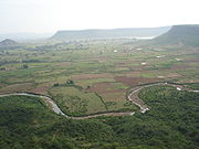 Madhya Pradesh represents great river basins
and the watershed of a number of rivers. Catchments of many rivers of India lie in Madhya Pradesh. The Narmada
(originating from Amarkantak
) and Tapti
(originating from Multai
of Betul District
) rivers and their basins divide the state in two, with the northern part draining largely into the Ganges
basin and the southern part into the Godavari
and Mahanadi
systems. The Vindhyas form the southern boundary of the Ganges basin, with the western part of the Ganges basin draining into the Yamuna
and the eastern part directly into the Ganges itself. All the rivers, which drain into the Ganges, flow from south to north, with the Chambal
, Shipra
, Kali Sindh
, Parbati
, Kuno, Sind, Betwa
, Dhasan
and Ken
rivers being the main tributaries of the Yamuna. The land drained by these rivers is agriculturally rich, with the natural vegetation largely consisting of grass
and dry deciduous forest types, largely thorny. The eastern part of the Ganges basin consists of the Son
, the Tons
and the Rihand Rivers, with the Son being the major tributary. This is also the junction point of the Satpura and the Vindhya ranges, with the Maikal Hills
and Kaimur Hills being the fulcrum. The forests here are much richer than the thorn forests of the northwestern part of Madhya Pradesh. The Son is of great significance in that it is the largest tributary going into the Ganges on the south bank and arising out of the hills of Madhya Pradesh rather than from the Himalayas
. This river and its tributaries contribute the bulk of the monsoon flow into the Ganges, because the north bank tributaries are all snow fed.
The major tributary of the Ganges, the Son, arises in one of the most important watersheds in India, the Maikal hills around Amarkantak
. Three of the great rivers of India, Narmada, Mahanadi and Son, are given birth to by these hills. This is also one of the few ranges in the State having a north south configuration. The Mahanadi itself, together with its tributaries such as Hasdeo, Mand
and Kharun flows southeast into Orissa
and converts that State into a green rice bowl. The upper Mahanadi catchment contains some of the finest forests in the State, ranging from mixed deciduous to teak
, bamboo
and sal. Just as the Mahanadi
flows east from the Maikal hills and the Son
flows north, the mighty Narmada
charts a westerly course from these very hills. The Narmada flows through a rift valley, with the Vindhyas marching along its northern bank and the Satpuras along the southern. Its tributaries include the Banjar
, the Tawa
, the Machna, the Denwa and the Sonbhardra rivers. Taken in combination with its parallel sister river, the Tapi
, which also flows through a rift valley, the Narmada–Tapi systems carry and enormous volume of water and provide drainage for almost a quarter of the land area of Madhya Pradesh.
The Satpuras (Pansemal), in the Gawilgarh and Mahadeo Hills
, also contain a watershed, which is south facing. The Indrawati, the Wainganga
, the Wardha
, the Pench
, the Kanhan and Penganga rivers, discharge an enormous volume of water into the Godavari
system. The Godavari is the lifeline of Andhra Pradesh
, but the water which feeds it is a gift of the Central India watershed. Some of the finest sub-tropical, semi moist forests in India are to be found in the Godavari basin, mainly in the valley of the Indrawati. There are very few virgin forests left in the country, but very fine examples of these are to be found in Bastar
area along the Indrawati and in the Kanger valley in Chhattisgarh.
The importance of Central India watershed was first noted by Captain Forsyth and remarked upon in his book, "The Highlands of Central India", first published in 1889. This is what he has to state in the introductory chapter to his book,
"Yet in the very center of India there exists a considerable region to which the term highlands — is strictly applicable; and in which are enormous peaks and ranges, for which the term mountain would, in any other country, be used. Several of the great rivers of India have their first source in this elevated region. And pour their water into the sea on either side of the peninsula – to the north the Son
commingling with the Ganges, to the east the Mahanadi
, flowing independently to the Bay of Bengal
, to the south some of the principal feeders of the Godavari
, and to the west the Narmada
and the Tapi
, Basli Dam Gohad (Bhind) taking parallel courses to the Arabian Sea
.
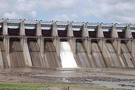
There are many important multi-state irrigation projects in development, including Godavari River Basin Irrigation Projects
.
Like most of north India, it has a hot dry summer(April–June) followed by monsoon rains (July–September) and a cool and relatively dry winter. The average rainfall is about 1370 mm (53.9 in). It decreases from east to west. The south-eastern districts have the heaviest rainfall, some places receiving as much as 2150 mm (84.6 in), while the western and north-western districts receive 1000 mm (39.4 in) or less.
 Madhya Pradesh is endowed with rich and diverse forest resources. Lying between lat. 21°04'N and long. 74°02' and 82°49' E, it is a reservoir of biodiversity
. The geographical area of the state is 308144 square kilometre which constitutes 9.38% of the land area of the country. The forest area of the state is 95221 square kilometre constituting 31% of the geographical area of the state and 12.44% of the forest area of the country. Legally this area has been classified into "Reserved Forest, Protected Forest and Unclassified Forest", which constitute 61.7%, 37.4% and 0.9% of the forest area respectively. Per capita forest area is 2400 m² (0.593052391236663 acre) as against the national average of 700 m² (0.172973614110693 acre).
Central, eastern and southern parts of the state are rich, whereas northern and western parts are deficient in forest.
Variability in climatic and edaphic
conditions brings about significant difference in the forest types of the state. There are four important forest types viz. Tropical Moist, Tropical Dry, Tropical Thorn, Subtropical broadleaved Hill forests.
The forest area can also be classified based on the composition of forest and terrain of the area. Based on composition, there are three important forest formations namely teak
, sal and miscellaneous forests. Bamboo-bearing areas are widely distributed in the state. To obviate pressure on the natural forests, plantations have been undertaken in forest and non forest areas to supplement the availability of fuel wood, small timber, fodder, etc. MP lost a good amount of forest recently when Chattisgarh was carved out of it, as that region was the richest reserve of forests in MP.
The total growing stock (volume of timber wood) is 50,000,000 m3 valued worth 2.5 lakh Crores.
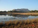 Madhya Pradesh is home to 9 National Parks
, including Bandhavgarh National Park
, Kanha National Park
, Satpura National Park
, Sanjay National Park
, Madhav National Park
, Van Vihar National Park
, Mandla Plant Fossils National Park
, Panna National Park
, and Pench National Park
.
There are also a number of natural preserves, including Amarkantak
, Bagh Caves
, Balaghat
, Bori Natural Reserve, Ken Gharial, Ghatigaon, Kuno Palpur, Narwar
, Chambal
, Kukdeshwar, Narsinghgarh
, Nora Dehi, Pachmarhi
, Panpatha, Shikarganj, Patalkot and Tamia.
in Satpura Range and Amarkantak biosphere reserve are two of the 17 Biosphere reserves in India.
compiled by the International Food Policy Research Institute
, the malnutrition situation in Madhya Pradesh is "extremely alarming", receiving a severity rating between Ethiopia
and Chad
.
Madhya Pradesh's gross state domestic product for 2004 is estimated at $32 billion in current prices. After partition, the new Madhya Pradesh state produces about 70% of the output of the old Madhya Pradesh state – the rest is produced by Chattisgarh. Between 1980 and 2000 the gross domestic product grew from 77,880 million rupees to 737,150 million rupees.
MFP from the forests, such as Tendu leaves used to roll bidi
, Sal seed, teak seed, and lak are major contributors to the rural economy of the state.
, Indore
, Jabalpur
, Gwalior
, Ujjain
, Rewa
, Sagar
, Chambal
, Shahdol
and Hoshangabad
.
Districts: Anuppur
, Alirajpur
, Ashoknagar, Balaghat
, Barwani
, Betul
, Bhind
, Bhopal
, Burhanpur
, Chhatarpur
, Chhindwara
, Damoh
, Datia
, Dewas
, Dhar
, Dindori
, Guna
, Gwalior
, Harda
, Hoshangabad
, Indore
, Jabalpur
, Jhabua
, Katni
, Khandwa
, Khargone
, Mandla
, Mandsaur
, Morena
, Narsinghpur
, Neemuch
, Panna
, Raisen
, Rajgarh
, Ratlam
, Rewa
, Sagar
, Satna
, Sehore
, Seoni
, Shahdol
, Shajapur
, Sheopur
, Shivpuri
, Sidhi
, Singrauli
, Tikamgarh
, Ujjain
, Umaria
, Vidisha
.
The major crops of Madhya Pradesh are wheat, rice, pulses, soy beans, and mustard.
Bhopal, ratlam
Indore
, Jabalpur, Gwalior Sagar and Ujjain
are considered the largest and most economically important cities of Madhya Pradesh.
Extensive rail network criss cross the state, with Jabalpur serving as headquarter for West Central Railway
Zone of Indian Railways
. The state has a total of 20 major railway junctions.
Buses and trains cover most of Madhya Pradesh. Extensive road network is also being developed. Madhya Pradesh leads in nation in implementing Gramin Sadak Nirman Pariyojna, a central government aided programme to provide road networks to villages. Jabalpur, Indore
and Bhopal have inter-state bus terminus. More than 2000 bus are conducted in a day from these three cities.
The state has five domestic airports located at Indore
, Bhopal, Jabalpur, Gwalior and Khajuraho
. Air strips are located at Ujjain
, Khandwa
and Satna
.
s and tribe
s, caste
s and communities. The population of Madhya Pradesh includes indigenous people and migrants from other states. According to census of 2000, 92% followed Hindu
religion while others are Muslim
(6%), Jain (0.9%), Christians (0.30%), Buddhists (0.30%), and Sikhs (0.20%).. .The scheduled castes and scheduled tribes constitute a significant portion of the population of the State. The scheduled castes are 13.14% while scheduled tribes were 20.63%.
Tribals in Madhya Pradesh
include Baiga, Bhariya, Bhil
s, Gondi people
, Kaul, Korku, Malto people
, Mariya, and Sahariya.
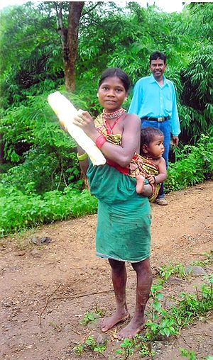
Madhya Pradesh has a substantial Tribal population. The differences in the tribal community, spread over in various parts of the state, is clearly seen not only on the basis of their heredity, lifestyle and cultural traditions, but also from their social, economic structure, religious beliefs and their language and speech. Due to the different linguistic, cultural and geographical environment, and its peculiar complications, the diverse tribal world of Madhya Pradesh has been largely cut-off from the mainstream of development. Veteran social activist and freedom fighter Guru Radha Kishan
lived between tribals in East Nimar and learned Korku to work between them to improve the conditions of widespread poverty and exploitations by moneylenders and shrewd traders. Being aware of this primarily cultivators community and their concerns with numerous socio-economic challenges in the day-to-day life he encouraged these innocent people to earn their livelihood through agriculture or even as seasonally employed agricultural labourers so that the community can be in the mainstream of the nation..
The population of Tribals in Madhya Pradesh is 122.33 lakh constituting 20.27% of the total population of Madhya Pradesh (603.85 Lakh), according to the 2001 census. There were 46 recognized Scheduled Tribes and three of them have been identified as "Special Primitive Tribal Groups" in the State.
The main tribal groups in Madhya Pradesh are Gond
, Bhil
, Baiga, Korku, Bhadia
, Halba, Kaul, Mariya, and Sahariya. Dhar
, Jhabua
and Mandla
districts have more than 50 percent tribal population. In Khargone
, Chhindwara
, Seoni, Sidhi
and Shahdol
districts 30 to 50 percent population is of tribes. Maximum population is that of Gond
tribes.
.
In addition to standard Hindi, several regional variants are spoken, which are considered by some to be dialects of Hindi, and by others to be distinct but related languages. Among these languages are Malvi
in Malwa, Nimadi
in Nimar
, Bundeli in Bundelkhand
, and Bagheli
in Bagelkhand
and the southeast. Each of these languages or dialects has dialects of its own. Other languages include Telugu, Bhilodi (Bhili
), Gondi
, Korku
, Kalto
(Nahali), and Nihali
(Nahali), all spoken by tribal groups. Due to rule of Maratha
s, Marathi
is spoken by a substantial number of people.
In addition, Saraiki
and Pashto are spoken by the large number of immigrants from Afghanistan
and North-West Frontier Province
, Pakistan
.
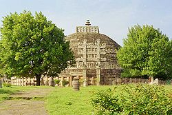
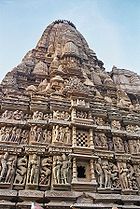
s by UNESCO
: the Khajuraho Group of Monuments
(1986) including Devi Jagadambi temple
, Buddhist Monuments at Sanchi
(1989) and the Rock Shelters of Bhimbetka (2003). Other architecturally significant or scenic sites include Ajaigarh
, Amarkantak
, Asirgarh
, Bandhavgarh, Bawangaja
, Bhopal, Chanderi
, Chitrakuta
, Dhar
, Gwalior, Indore
, Burhanpur
, Maheshwar
, Mandleshwar
, Mandu, Omkareshwar
, Orchha
, Pachmarhi
, Shivpuri
, Sonagiri
, Mandla
and Ujjain
. MP being very large geographically, and the history being spread over several millennia, developing a comprehensive picture of heritage and architecture is a monumental task.
Madhya Pradesh has a prominent role in classical music.
is one of the oldest Khayal Gharanas and one to which most classical Indian musicians can trace the origin of their style. The rise of the Gwalior Gharana started with the reign of the great Mughal emperor Akbar (1542–1605). The favorite singers of this patron of the arts, such as Miyan Tansen
, first amongst the vocalists at the court, came from the town of Gwalior.
Gwalior has an important role in the journey of music in India, so that every year Tansen Festival is celebrated at the tomb of Tansen in Gwalior.
Raja Man Singh Tomar
The king of Gwalior [during 1486 A.D.-1516 A.D.]was parton of Dhrupad.
Faga,
Bhartahari,
Sanja geet ,
Bhopa ,
kal belia,
Bhat/bhand/charan,
vasdeva,
videsia,
Kalgi turra,
Nirgunia,
Alha ,
Pandwani gayan ,
Garba Garbi Govalan,
Badhai, Rai, Saira, Jawara, Sher, Akhara, Shaitan, baredi , karma, kathi, Sua, Saila, Mauni, Dhimrai, kanara, Bhagoria, Dashera, dadariya, Duldul Ghodi, Lehgi ghodi, Fefriya, Mandlya, danda, Ada-khada, dadel, Matki, birha, Ahirai, pardhauni, Vilma, Dadar, kalsa.
 According to the 2001 census, Madhya Pradesh had a literacy rate of 63.74%. The state is home to some of the premier educational and research institutions of India such as the Indian Institute of Technology Indore
, Indian Institute of Information Technology and Management, Gwalior, school of planning and architecture
, Bhopal, Indian Institute of Management Indore
, Indian Institute of Forest Management
,, National Law Institute University Bhopal, Maulana Azad National Institute of Technology
Bhopal, Madhav Institute of Technology and Science, Gwalior, Indian Institute of Soil Science, Indian Institute of Hotel Management Bhopal, Lakshmibai National Institute of Physical Education (LNIPE) Gwalior, Shri Govindram Seksaria Institute of Technology and Science
Indore, Lakshmibai National University of Physical Education (Deemed University),Gwalior, Makhanlal Chaturvedi National University of Journalism & Communication, Bhopal. Madhya Pradesh also has a University of music, Raja Mansingh Tomar Sangeet Vishvavidyalaya, Gwalior. Madhya Pradesh has the second oldest engineering college in India the JEC (Jabalpur Engineering College
) and one of the oldest medical colleges in India Netaji Subhash Chandra Bose Medical College
, Shri Govindram Seksaria College, Jabalpur. Jabalpur being a British established city has got a number of mission colleges, engineering colleges and schools.
 There are 500 degree colleges affiliated with one of the universities in the state, viz. Jawaharlal Nehru Agriculture University, Madhya Pradesh Veterinary Sciences University, Madhya Pradesh Medical University, Rajiv Gandhi Technical University, Barkatullah University, Devi Ahilya University, Rani Durgavati University
, Vikram University, Jiwaji University
Gwalior etc.
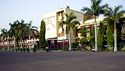
The Indian Institute of Management Indore
is a state-funded management institute in Indore. Instituted in 1998, IIM Indore is the sixth addition to the prestigious IIM family. Known as "Prabandh Shikhar" or "Peak of Management", the scenic 193 acre (781,000 m²) campus is located atop a small hill on the outskirts of Indore. It is about 20 kilometres from the Railway station and almost 25 Kilometres from the airport. It is among the top ten B-schools of India.
The Mahatma Gandhi Chitrakoot Gramoday VishwavidyalayaThe University receives inspiration for rural development in consonance with the vision of Mahatma Gandhi. The University is mandated to evolve, promote and impart higher education so as to take up emerging challenges for transformation of rural areas. It undertakes academic, research, extension and training programmes for the empowerment of the people with a view to ensure free flow of knowledge, techniques and technologies as a two–way process for betterment of rural life. It provides training facilities to personnel engaged in rural development in collaboration with the state government. The University provides consultancy in all aspects of rural development. The University undertakes monitoring and evaluation of national and state-level development programmes, shares ideas and experiences in rural development work.
The Indian Institute of Forest Management
(IIFM) (founded 1982) is an autonomous institution located at Bhopal in Madhya Pradesh, established by the Ministry of Environment and Forests, Government of India with financial assistance from the Swedish International Development Cooperation Agency (SIDA) and course assistance from the Indian Institute of Management Ahmedabad. It is the only Forest Management Institute in India.
The Indian Institute of Science Education and Research, Bhopal (IISERB) is an autonomous institute of higher education for research and education in science established by the federal Ministry of Human Resource Development in 2008. Professor Vinod K Singh is the founder Director of IISER Bhopal.
The Jaypee University of Engineering and Technology, Guna
, one of the premier Indian Engineering University is acting as a center of excellence for higher education in field of technology. It is well known for its academics, infrastructure and placements all over India
.
Defence Research and Development Establishment, Gwalior (DRDE) is an Indian defense laboratory of the Defence Research and Development Organisation
. Located in Gwalior, it is primarily involved in the research and development of detection and protection against toxic chemical and biological agents.
The Daly College, Indore is one of the best school's of India and is ranked as the country's 5th best school. It is a very well-known school which is a part of the G20 schools of the world along with The Doon School, Dehra Doon from India. It is also a part of the Round Square.
The Indian Institute of Technology, Indore, established in 2009, is part of this mega-project that envisages India as a Global Technology Leader.
, Raj Express, BPN Times, Nai Duniya, Patrika, Rajsthan Patrika, Dainik Bhaskar
, Dainik Jagran
and Mahakaushal Samay Chakra are the leading Hindi
Newspapers. It is first ever news paper exclusively for Youth of MP, Akbar Times are prominent Hindi newspapers. Various other local newspapers are also published in various cities.
In English, Times of India, Hindustan Times
, Central Chronicle and Free Press have editions from Bhopal. Urdu journals is common in Bhopal. Nadeem
, the oldest Urdu
newspaper of the state, is published from Bhopal. Urdu Action and Haq-o-Insaf are also published. Farz, a Sindhi daily is published from Bhopal is the only Sindhi newspaper in State.
The Madhya Pradesh government has gone live with its MP Online portal having urban planner Ashish kumar Chauhan SPA-Bhopal, a joint venture with Tata Consultancy Services. The State has tied up with Bajaj Allianz, Tata Aig and LIC, to enable their customers to payinsurance premiums online. Citizens can also recharge their mobile prepaid accounts online for Airtel, Tata Docomo, Tata Indicom and BSNL Phones. They can also book private tours of state national parks like Kanha and Bandavgarh online. Victims of Bhopal gas tragedy can apply for free medical facilities, state incentives online.
.
Also some traditional games are played in rural areas:
MP government has declared Malkhambh is the state game of M.P in 2008.
Various awards in MP to honour the sportspersons are:
States and territories of India
India is a federal union of states comprising twenty-eight states and seven union territories. The states and territories are further subdivided into districts and so on.-List of states and territories:...
in central India
India
India , officially the Republic of India , is a country in South Asia. It is the seventh-largest country by geographical area, the second-most populous country with over 1.2 billion people, and the most populous democracy in the world...
. Its capital is Bhopal and Indore
Indore
Indore is one of the major city in India, the largest city and commercial center of the state of Madhya Pradesh in central India. Indore is located 190 km west of the state capital Bhopal. According to the 2011 Indian census, Indore city has a population of 1,960,631...
is the largest city.
Madhya Pradesh is the second largest state by area and sixth largest state by population. It borders the states of Uttar Pradesh
Uttar Pradesh
Uttar Pradesh abbreviation U.P. , is a state located in the northern part of India. With a population of over 200 million people, it is India's most populous state, as well as the world's most populous sub-national entity...
, Chhattisgarh
Chhattisgarh
Chhattisgarh is a state in Central India, formed when the 16 Chhattisgarhi-speaking South-Eastern districts of Madhya Pradesh gained separate statehood on 1 November 2000....
, Maharashtra
Maharashtra
Maharashtra is a state located in India. It is the second most populous after Uttar Pradesh and third largest state by area in India...
, Gujarat and Rajasthan
Rajasthan
Rājasthān the land of Rajasthanis, , is the largest state of the Republic of India by area. It is located in the northwest of India. It encompasses most of the area of the large, inhospitable Great Indian Desert , which has an edge paralleling the Sutlej-Indus river valley along its border with...
.
History
Rama
Rama or full name Ramachandra is considered to be the seventh avatar of Vishnu in Hinduism, and a king of Ayodhya in ancient Indian...
bequeathed the fort to his brother Laxmana, hence the name Bandhavgarh (Bandhavgarh National Park
Bandhavgarh National Park
Bandhavgarh National Park is one of the popular national parks in India located in the Umaria district of Madhya Pradesh. Bandhavgarh was declared a national park in 1968 with an area of 105 km². The buffer is spread over the forest divisions of Umaria and Katni and totals 437 km²...
) which means "brother's fort". The Bhimbetka rock shelters in Madhya Pradesh exhibit the earliest traces of human life in India; its stone-age rock paintings are approximately 9,000 years old.
The city of Ujjain
Ujjain
Ujjain , is an ancient city of Malwa region in central India, on the eastern bank of the Kshipra River , today part of the state of Madhya Pradesh. It is the administrative centre of Ujjain District and Ujjain Division.In ancient times the city was called Ujjayini...
(also known as Avanti) arose as a major center in the second wave of Indian urbanization in the sixth century BC, and served as the chief city of the kingdom of Malwa or Avanti. Further east, the kingdom of Chedi
Chedi Kingdom
Chedi kingdom was one among the many kingdoms ruled during early periods by Paurava kings and later by Yaduvanshi Rajput kings in the central and western India. It falls roughly in the Bundelkhand division of Madhya Pradesh regions to the south of river Yamuna and along river Betwa or Vetravati...
lie in Bundelkhand
Bundelkhand
Bundelkhand anciently known as Chedi Kingdom is a geographic region of central India...
. Chandragupta Maurya
Chandragupta Maurya
Chandragupta Maurya , was the founder of the Maurya Empire. Chandragupta succeeded in conquering most of the Indian subcontinent. Chandragupta is considered the first unifier of India and its first genuine emperor...
united northern India c. 320 BC, establishing the Maurya empire
Maurya Empire
The Maurya Empire was a geographically extensive Iron Age historical power in ancient India, ruled by the Mauryan dynasty from 321 to 185 BC...
(321 to 185 BC), which included all of modern-day Madhya Pradesh. King Ashoka's wife was said to come from Vidisha
Vidisha
Vidisha is a city in the state of Madhya Pradesh, India, located near the state capital Bhopal. Vidishā is the administrative headquarters of Vidisha District. The city was also known as Bhilsa during the medieval period.-Geography:...
- a town north of today's Bhopal. The Maurya empire went into decline after the death of Asoka the Great, and Central India was contested among the Saka
Saka
The Saka were a Scythian tribe or group of tribes....
s, Kushanas, and local dynasties during the 3rd to 1st centuries BCE. Ujjain emerged as the predominant commercial center of western India from the first century BCE, located on the trade routes between the Ganges plain and India's Arabian Sea
Arabian Sea
The Arabian Sea is a region of the Indian Ocean bounded on the east by India, on the north by Pakistan and Iran, on the west by the Arabian Peninsula, on the south, approximately, by a line between Cape Guardafui in northeastern Somalia and Kanyakumari in India...
ports. It was also an important Hindu
Hindu
Hindu refers to an identity associated with the philosophical, religious and cultural systems that are indigenous to the Indian subcontinent. As used in the Constitution of India, the word "Hindu" is also attributed to all persons professing any Indian religion...
and Buddhist center.
Satavahana
The Sātavāhana Empire or Andhra Empire, was a royal Indian dynasty based from Dharanikota and Amaravati in Andhra Pradesh as well as Junnar and Prathisthan in Maharashtra. The territory of the empire covered much of India from 230 BCE onward...
dynasty of the northern Deccan and the Saka
Saka
The Saka were a Scythian tribe or group of tribes....
dynasty of the Western Satraps fought for the control of Madhya Pradesh during the 1st to 3rd centuries CE. Northern India was conquered by the Gupta empire
Gupta Empire
The Gupta Empire was an ancient Indian empire which existed approximately from 320 to 550 CE and covered much of the Indian Subcontinent. Founded by Maharaja Sri-Gupta, the dynasty was the model of a classical civilization. The peace and prosperity created under leadership of Guptas enabled the...
in the 4th and 5th centuries, which became known as India's "classical age". The Vakataka
Vakataka
The Vākāṭakas were a royal Indian dynasty that originated from the Deccan in the mid-third century CE. Their kingdom is believed to have extended from the southern edges of Malwa and Gujarat in the north to the Tungabhadra River in the south as well as from the Arabian Sea in the western to the...
dynasty were the southern neighbors of the Guptas, ruling the northern Deccan plateau from the Arabian Sea
Arabian Sea
The Arabian Sea is a region of the Indian Ocean bounded on the east by India, on the north by Pakistan and Iran, on the west by the Arabian Peninsula, on the south, approximately, by a line between Cape Guardafui in northeastern Somalia and Kanyakumari in India...
to the Bay of Bengal
Bay of Bengal
The Bay of Bengal , the largest bay in the world, forms the northeastern part of the Indian Ocean. It resembles a triangle in shape, and is bordered mostly by the Eastern Coast of India, southern coast of Bangladesh and Sri Lanka to the west and Burma and the Andaman and Nicobar Islands to the...
. These empires collapsed towards the end of the 5th century.
Medieval
Hephthalite
The Hephthalites or Hephthalite is a pre-Islamic Greek term for local Abdali Afghans, who's famous ruler was Nazak Abdali . Hephthalites were a Central Asian nomadic confederation of the AD 5th-6th centuries whose precise origins and composition remain obscure...
s or White Huns brought about the collapse of the Gupta empire, and India broke up into smaller states. A king Yasodharman
Yasodharman
Yasodharman or Yashôdharman was the king of Malwa, in central India, during the early part of the 6th century.- History :...
of Malwa defeated the Huns in 528, ending their expansion. King Harsha
Harsha
Harsha or Harsha Vardhana or Harshvardhan was an Indian emperor who ruled northern India from 606 to 647 AD. He was the son of Prabhakara Vardhana and younger brother of Rajya Vardhana, a king of Thanesar, Haryana...
of Thanesar
Thanesar
Thanesar is an old and historic town on the banks of the Sarsawati Ghaggar river in the state of Haryana in northern India. It is located in Kurukshetra District, approximately 160 km northwest of Delhi...
reunited northern India for a few decades before his death in 647. The Medieval period saw the rise of the Rajput
Rajput
A Rajput is a member of one of the patrilineal clans of western, central, northern India and in some parts of Pakistan. Rajputs are descendants of one of the major ruling warrior classes in the Indian subcontinent, particularly North India...
clans, including the Paramara
Paramara
Paramara is a Maratha, Gurjar,& Rajput clan of India.The Paramara clan belongs to the Agnivansha of Rajputs ancient Kshatriyas...
s of Malwa and the Chandela
Chandela
The Chandela is a Rajput clan found in North India. A section of the Chandelas ruled much of the Bundelkhand region of central India for long periods between the 10th and the 13th centuries AD. The Chandela dynasty is famous in Indian history for King Vidyadhar, who repulsed the attacks of Mahmud...
s of Bundelkhand
Bundelkhand
Bundelkhand anciently known as Chedi Kingdom is a geographic region of central India...
. The Paramara king Bhoja
Bhoja
Bhoja was a philosopher king and polymath of medieval India, who ruled the kingdom of Malwa in central India from about 1000 to 1050 CE. Also known as Raja Bhoja Of Dhar, he belonged to the Paramara dynasty...
(c. 1010–1060) was a brilliant polymath
Polymath
A polymath is a person whose expertise spans a significant number of different subject areas. In less formal terms, a polymath may simply be someone who is very knowledgeable...
and prolific writer. The Chandelas created the temple city of Khajuraho
Khajuraho
The Khajuraho Group of Monuments in Khajuraho , a town in the Indian state of Madhya Pradesh, located in Chhatarpur District, about southeast of New Delhi, are one of the most popular tourist destinations in India. Khajuraho has the largest group of medieval Hindu and Jain temples, famous for...
between c. 950 and c. 1050. Gond
Gondi people
The Gondi, Goindi or Gond people are people in central India, spread over the states of Madhya Pradesh, eastern Maharashtra , Chhattisgarh, northern Andhra Pradesh, and Western Orissa. With over four million people, they are the largest tribe in Central India.The Gondi language is related to...
kingdoms emerged in Gondwana and Mahakoshal. Northern Madhya Pradesh was conquered by the Muslim
Muslim
A Muslim, also spelled Moslem, is an adherent of Islam, a monotheistic, Abrahamic religion based on the Quran, which Muslims consider the verbatim word of God as revealed to prophet Muhammad. "Muslim" is the Arabic term for "submitter" .Muslims believe that God is one and incomparable...
Delhi Sultanate
Delhi Sultanate
The Delhi Sultanate is a term used to cover five short-lived, Delhi based kingdoms or sultanates, of Turkic origin in medieval India. The sultanates ruled from Delhi between 1206 and 1526, when the last was replaced by the Mughal dynasty...
in the 13th century. After the collapse of the Delhi Sultanate at the end of the 14th century, independent regional kingdoms reemerged, including the Tomara Rajput kingdom of Gwalior and the Muslim Sultanate of Malwa, with its capital at Mandu. The Malwa Sultanate was conquered by the Sultanate of Gujarat in 1531. Sher Shah Suri, the Afghan king took the reigns of the area in 1540 after defeating Humanyun. Hemu
Hemu
Samrat Hem Chandra Vikramaditya, Hemu Vikramaditya or simply Hemu was a Hindu Emperor of India during the sixteenth century, in medieval times...
, the Hindu General of Afghans shifted the capital of Afghans from Delhi to Gwalior in 1552. Islam Shah, the son of Sher shah Suri appointed Hemu, as the Prime Minister-cum-Chief of Army of his regime in the Gwalior Fort
Gwalior Fort
ċċċċċt̪--122.177.251.15 13:02, 20 November 2011 --122.177.251.15 13:02, 20 November 2011 --122.177.251.15 13:02, 20 November 2011 Gwalior Fort in Gwalior, in the central Indian state of Madhya Pradesh, stands on an isolated rock, overlooking the Gwalior town, and contains a number of historic...
and Hemu launched several attacks from Gwalior fort on the Afghan rebels. In all Hemu won 22 battles throughout North India in between 1553–56. Hemu also launched an attack on Akbar's forces in Agra
Agra
Agra a.k.a. Akbarabad is a city on the banks of the river Yamuna in the northern state of Uttar Pradesh, India, west of state capital, Lucknow and south from national capital New Delhi. With a population of 1,686,976 , it is one of the most populous cities in Uttar Pradesh and the 19th most...
and Delhi
Delhi
Delhi , officially National Capital Territory of Delhi , is the largest metropolis by area and the second-largest by population in India, next to Mumbai. It is the eighth largest metropolis in the world by population with 16,753,265 inhabitants in the Territory at the 2011 Census...
and defeated his army, thus winning Delhi and established native Vedic Sanskriti oriented 'Hindu Raj' in North India. He was bestowed with the title of 'Vikramaditya' king on his victory in Delhi over Akbar at his 'Rajyabhishake' or coronation ceremony in Purana Quila in Delhi. Hemu lost his life in the Second Battle of Panipat
Second battle of Panipat
The Second Battle of Panipat was fought between the forces of Samrat Hem Chandra Vikramaditya, popularly called Hemu, the Hindu king who was ruling North India from Delhi, and the army of Jalal ud-Din Muhammad Akbar, on November 5, 1556...
in Nov. 1556 to Akbar, and most of Madhya Pradesh came under Mughal
Mughal Empire
The Mughal Empire , or Mogul Empire in traditional English usage, was an imperial power from the Indian Subcontinent. The Mughal emperors were descendants of the Timurids...
rule during the reign of the emperor Akbar (1556–1605). Gondwana and Mahakoshal remained under the control of Gond kings, who acknowledged Mughal supremacy but enjoyed virtual autonomy. After the death of the Mughal emperor Aurangzeb
Aurangzeb
Abul Muzaffar Muhy-ud-Din Muhammad Aurangzeb Alamgir , more commonly known as Aurangzeb or by his chosen imperial title Alamgir , was the sixth Mughal Emperor of India, whose reign lasted from 1658 until his death in 1707.Badshah Aurangzeb, having ruled most of the Indian subcontinent for nearly...
in 1707 Mughal control began to weaken, and the Maratha
Maratha
The Maratha are an Indian caste, predominantly in the state of Maharashtra. The term Marāthā has three related usages: within the Marathi speaking region it describes the dominant Maratha caste; outside Maharashtra it can refer to the entire regional population of Marathi-speaking people;...
s began to expand from their base in central Maharashtra. Between 1720 and 1760 the Marathas took control of most of Madhya Pradesh, and Maratha clans were established semi-autonomous states under the nominal control of the Maratha Peshwa
Peshwa
A Peshwa is the titular equivalent of a modern Prime Minister. Emporer Shivaji created the Peshwa designation in order to more effectively delegate administrative duties during the growth of the Maratha Empire. Prior to 1749, Peshwas held office for 8-9 years and controlled the Maratha army...
. The Holkar
Holkar
The Holkar dynasty , whose earliest known clan-man was Malhar Rao, who joined the service of the Peshwa in 1721, and quickly rose to the ranks of Subedar...
s of Indore
Indore
Indore is one of the major city in India, the largest city and commercial center of the state of Madhya Pradesh in central India. Indore is located 190 km west of the state capital Bhopal. According to the 2011 Indian census, Indore city has a population of 1,960,631...
ruled much of Malwa, and the Bhonsle
Bhonsle
The Bhonsle were a prominent clan within the Maratha clan system who served as rulers of several states in India.The most prominent member of the clan was Shivaji, the founder of the Maratha empire...
s of Nagpur
Nagpur
Nāgpur is a city and winter capital of the state of Maharashtra, the largest city in central India and third largest city in Maharashtra after Mumbai and Pune...
dominated Mahakoshal
Mahakoshal
Mahakoshal is a region of central India. Mahakoshal lies in the upper or eastern reaches of the Narmada River valley in the Indian state of Madhya Pradesh. Jabalpur is the largest city in the region. Nimar region lies to the west, in the lower reaches of the Narmada valley...
and Gondwana
Gondwana
In paleogeography, Gondwana , originally Gondwanaland, was the southernmost of two supercontinents that later became parts of the Pangaea supercontinent. It existed from approximately 510 to 180 million years ago . Gondwana is believed to have sutured between ca. 570 and 510 Mya,...
as well as Vidarbha
Vidarbha
Vidarbha is the eastern region of Maharashtra state made up of Nagpur Division and Amravati Division. Its former name is Berar . It occupies 31.6% of total area and holds 21.3% of total population of Maharashtra...
in Maharashtra. Jhansi
Jhansi
Jhansi Hindi:झाँसी, , Marathi: झाशी, is a historical city of India. Jhansi is the administrative headquarters of Jhansi District and Jhansi Division. The original walled city grew up around its stone fort, which crowns a neighboring rock. This district is on the bank of river Betwa.The National...
was founded by a Maratha general. Bhopal was ruled by a Muslim dynasty descended from Dost Mohammed Khan
Dost Mohammad Khan, Nawab of Bhopal
Dost Mohammad Khan was the founder of the Bhopal State in central India. He laid out the modern city of Bhopal, the capital of the Madhya Pradesh state....
, an Afghan
Afghanistan
Afghanistan , officially the Islamic Republic of Afghanistan, is a landlocked country located in the centre of Asia, forming South Asia, Central Asia and the Middle East. With a population of about 29 million, it has an area of , making it the 42nd most populous and 41st largest nation in the world...
General in the Mughal army. Maratha expansion was checked at the Third Battle of Panipat
Third battle of Panipat
The Third Battle of Panipat took place on 14 January 1761, at Panipat , about 60 miles north of Delhi between a northern expeditionary force of the Maratha Confederacy and a coalition of the King of Afghanistan, Ahmad Shah Abdali with 2 Indian Muslim allies—the Rohilla Afghans of the Doab, and the...
in 1761.
Modern
The British were expanding their Indian dominions from bases in BengalBengal
Bengal is a historical and geographical region in the northeast region of the Indian Subcontinent at the apex of the Bay of Bengal. Today, it is mainly divided between the sovereign land of People's Republic of Bangladesh and the Indian state of West Bengal, although some regions of the previous...
, Bombay, and Madras, and the three Anglo-Maratha Wars
Anglo-Maratha Wars
The Anglo-Maratha Wars were three wars fought in India between the Maratha Empire and the British East India Company:* First Anglo-Maratha War * Second Anglo-Maratha War...
were fought between 1775 and 1818. The Third Anglo-Maratha War
Third Anglo-Maratha War
The Third Anglo-Maratha War was the final and decisive conflict between the British East India Company and the Maratha Empire in India. The war left the Company in control of most of India. It began with an invasion of Maratha territory by 110,400 British East India Company troops, the largest...
left the British supreme in India. Most of Madhya Pradesh, including the large states of Indore
Indore
Indore is one of the major city in India, the largest city and commercial center of the state of Madhya Pradesh in central India. Indore is located 190 km west of the state capital Bhopal. According to the 2011 Indian census, Indore city has a population of 1,960,631...
, Bhopal, Nagpur, Rewa
Rewa (princely state)
Rewa was a princely state of India, surrounding its eponymous capital, the town of Rewa.-Description:With an area of about 13,000 mi², Rewa was the largest princely state in the Bagelkhand Agency and the second largest in Central India Agency. The British political agent for Bagelkhand resided...
, and dozens of smaller states, became princely state
Princely state
A Princely State was a nominally sovereign entitity of British rule in India that was not directly governed by the British, but rather by an Indian ruler under a form of indirect rule such as suzerainty or paramountcy.-British relationship with the Princely States:India under the British Raj ...
s of British India, and the Mahakoshal region became a British province, the Saugor and Nerbudda Territories
Saugor and Nerbudda Territories
The Saugor and Nerbudda Territories was a region of British India, located in central part of present-day Madhya Pradesh state in central India. It includes the present-day districts of Sagar , Damoh, Jabalpur, and Narsinghpur...
. In 1853 the British annexed the state of Nagpur
Nagpur
Nāgpur is a city and winter capital of the state of Maharashtra, the largest city in central India and third largest city in Maharashtra after Mumbai and Pune...
, which included southeastern Madhya Pradesh, eastern Maharashtra and most of Chhattisgarh
Chhattisgarh
Chhattisgarh is a state in Central India, formed when the 16 Chhattisgarhi-speaking South-Eastern districts of Madhya Pradesh gained separate statehood on 1 November 2000....
, which were combined with the Saugor and Nerbudda Territories to form the Central Provinces
Central Provinces
The Central Provinces was a province of British India. It comprised British conquests from the Mughals and Marathas in central India, and covered parts of present-day Madhya Pradesh, Chhattisgarh and Maharashtra states. Its capital was Nagpur....
in 1861. The princely states of northern Madhya Pradesh were governed by the Central India Agency
Central India Agency
The Central India Agency was a political office of the British Indian Empire, which covered the northern half of present-day Madhya Pradesh state. The Central India Agency was made up entirely of princely states, which were under native rulers...
.
After Indian independence
Madhya Pradesh was created in 1950 from the former British Central Provinces and BerarCentral Provinces and Berar
The Central Provinces and Berar was a province of British India. The province comprised British conquests from the Mughals and Marathas in central India, and covered much of present-day Madhya Pradesh, Chhattisgarh and Maharashtra states. Its capital was Nagpur. The Central Provinces was formed in...
and the princely states of Makrai
Makrai
Makrai was a princely state of India from the 16th century, later coming under the administrative authority of the Central Provinces and Berar until 1933, when it was transferred to the Bhopal Agency subdivision of the Central India Agency. In 1892, it covered an area of and had a population of...
and Chhattisgarh, with Nagpur
Nagpur
Nāgpur is a city and winter capital of the state of Maharashtra, the largest city in central India and third largest city in Maharashtra after Mumbai and Pune...
as the capital of the state. The new states of Madhya Bharat
Madhya Bharat
Madhya Bharat , also known as Malwa Union was an Indian state in west-central India, created on 28 May 1948 from twenty-five princely states which until 1947 had been part of the Central India Agency, with Jivaji Rao Scindia as its Rajpramukh...
, Vindhya Pradesh
Vindhya Pradesh
Vindhya Pradesh is a former state of India. It occupied an area of 23,603 sq. miles. It was created in 1948, shortly after Indian independence, from the territories of the princely states in the eastern portion of the former Central India Agency. It was named for the Vindhya Range, which runs...
, and Bhopal
Bhopal State (1949-1956)
Bhopal was the name of state of India, which existed from 1949 to 1956. The state evolved out of the princely state of Bhopal, and was merged with neighboring states to form Madhya Pradesh in 1956. Shankar Dayal Sharma served as chief minister of Bhopal state from 1952 to 1956.- History :Before the...
were formed out of the Central India Agency
Central India Agency
The Central India Agency was a political office of the British Indian Empire, which covered the northern half of present-day Madhya Pradesh state. The Central India Agency was made up entirely of princely states, which were under native rulers...
. In 1956, the states of Madhya Bharat, Vindhya Pradesh, and Bhopal were merged into Madhya Pradesh, and the Marathi
Marathi language
Marathi is an Indo-Aryan language spoken by the Marathi people of western and central India. It is the official language of the state of Maharashtra. There are over 68 million fluent speakers worldwide. Marathi has the fourth largest number of native speakers in India and is the fifteenth most...
-speaking southern region Vidarbha
Vidarbha
Vidarbha is the eastern region of Maharashtra state made up of Nagpur Division and Amravati Division. Its former name is Berar . It occupies 31.6% of total area and holds 21.3% of total population of Maharashtra...
, which included Nagpur, was ceded to Bombay state
Bombay State
The Bombay State was a state of India, dissolved with the formation of Maharashtra and Gujarat states on May 1, 1960.-History:During British rule, portions of the western coast of India under direct British rule were part of the Bombay Presidency...
. Bhopal became the new capital of the state. Madhya Pradesh, in its present form, came into existence on 1 November 2000, following its bifurcation to create a new state of Chhattisgarh
Chhattisgarh
Chhattisgarh is a state in Central India, formed when the 16 Chhattisgarhi-speaking South-Eastern districts of Madhya Pradesh gained separate statehood on 1 November 2000....
. The undivided Madhya Pradesh was founded on 1 November 1956. Madhya Pradesh, because of its central location in India, has remained a crucible of historical currents from North, South, East and West.
Government and politics
The constitutional head of the state is the governor, appointed by the President of India. The current governor is Ram Naresh YadavRam Naresh Yadav
Ram Naresh Yadav , is the former Chief Minister of Uttar Pradesh, India. He was from Janata Party, later he joined the Congress. He was appointed Governor of Madhya Pradesh on 26th August 2011 by President Pratibha Patil and was sworn into office on 8 September 2011.He was born on 1 July 1928in...
.
Madhya Pradesh has a 230-seat state Legislative Assembly
Legislative Assembly
Legislative Assembly is the name given in some countries to either a legislature, or to one of its branch.The name is used by a number of member-states of the Commonwealth of Nations, as well as a number of Latin American countries....
. The state also sends 40 members to the Parliament of India
Parliament of India
The Parliament of India is the supreme legislative body in India. Founded in 1919, the Parliament alone possesses legislative supremacy and thereby ultimate power over all political bodies in India. The Parliament of India comprises the President and the two Houses, Lok Sabha and Rajya Sabha...
: 29 are elected to the Lok Sabha
Lok Sabha
The Lok Sabha or House of the People is the lower house of the Parliament of India. Members of the Lok Sabha are elected by direct election under universal adult suffrage. As of 2009, there have been fifteen Lok Sabhas elected by the people of India...
(Lower House) and 11 to the Rajya Sabha
Rajya Sabha
The Rajya Sabha or Council of States is the upper house of the Parliament of India. Rajya means "state," and Sabha means "assembly hall" in Sanskrit. Membership is limited to 250 members, 12 of whom are chosen by the President of India for their expertise in specific fields of art, literature,...
(Upper House).
The dominant political parties in the state are the Bharatiya Janata Party
Bharatiya Janata Party
The Bharatiya Janata Party ,; translation: Indian People's Party) is one of the two major political parties in India, the other being the Indian National Congress. Established in 1980, it is India's second largest political party in terms of representation in the parliament...
(BJP) and the Indian National Congress
Indian National Congress
The Indian National Congress is one of the two major political parties in India, the other being the Bharatiya Janata Party. It is the largest and one of the oldest democratic political parties in the world. The party's modern liberal platform is largely considered center-left in the Indian...
. Unlike many of its neighbours, Madhya Pradesh has largely a two-party system with small or regional parties not having had much success in recent elections.
In the November 2008 state elections, the BJP won an absolute majority of 143 seats, defeating Congress who won just 71 seats. Other parties in the state legislature include the Bahujan Samaj Party
Bahujan Samaj Party
The Bahujan Samaj Party is a centrist national political party in India with socialist leanings. It was formed to chiefly represent Bahujans , referring to people from the Scheduled Castes, Scheduled Tribes and Other Backward Castes as well as Buddhists. The party claims to be inspired by the...
with seven seats.
The current chief minister is Shivraj Singh Chouhan, who succeeded Babulal Gaur
Babulal Gaur
Babulal Gaur is a current cabinet minister in BJP ministry of Madhya Pradesh and a former Chief Minister of Madhya Pradesh, India. He was born in a Yadav family in a village in Uttar Pradesh. He served as chief minister from August 23 2004 following the resignation of Uma Bharti...
and Uma Bharti
Uma Bharti
Uma Ragini Bharti , is an Indian politician. She was born in Tikamgarh District, Madhya Pradesh to a religious Lodhi Rajput family and from a very young age, started holding discourses on Indian Epics.Her father was an atheist...
. Before the BJP won in 2003, the longtime Congress Chief Minister was Digvijay Singh. In the 2004 General Election
Indian general election, 2004
Legislative elections were held in India in four phases between April 20 and May 10, 2004. Over 670 million people were eligible to vote, electing 543 members of the 14th Lok Sabha...
the BJP swept the state by winning 25 of the 29 seats, while the Congress won the remaining four.
Geography
Narmada River
The Narmada , also called Rewa is a river in central India and the fifth largest river in the Indian subcontinent. It is the third largest river that completely flows within India after Ganges and Godavari...
, which runs east and west between the Vindhya
Vindhya Range
The Vindhya Range is a range of older rounded mountains and hills in the west-central Indian subcontinent, which geographically separates the Indian subcontinent into northern India and Southern India.- Introduction :...
and Satpura
Satpura Range
The Satpura Range is a range of hills in central India. The range rises in eastern Gujarat state near the Arabian Sea coast, running east through Maharashtra and Madhya Pradesh to Chhattisgarh. The range parallels the Vindhya Range to the north, and these two east-west ranges divide the...
ranges; these ranges and the Narmada are the traditional boundary between the north and south of India. The state is bordered on the west by Gujarat, on the northwest by Rajasthan
Rajasthan
Rājasthān the land of Rajasthanis, , is the largest state of the Republic of India by area. It is located in the northwest of India. It encompasses most of the area of the large, inhospitable Great Indian Desert , which has an edge paralleling the Sutlej-Indus river valley along its border with...
, on the northeast by Uttar Pradesh
Uttar Pradesh
Uttar Pradesh abbreviation U.P. , is a state located in the northern part of India. With a population of over 200 million people, it is India's most populous state, as well as the world's most populous sub-national entity...
, on the east by Chhattisgarh, and on the south by Maharashtra
Maharashtra
Maharashtra is a state located in India. It is the second most populous after Uttar Pradesh and third largest state by area in India...
.
Rivers
Drainage basin
A drainage basin is an extent or an area of land where surface water from rain and melting snow or ice converges to a single point, usually the exit of the basin, where the waters join another waterbody, such as a river, lake, reservoir, estuary, wetland, sea, or ocean...
and the watershed of a number of rivers. Catchments of many rivers of India lie in Madhya Pradesh. The Narmada
Narmada River
The Narmada , also called Rewa is a river in central India and the fifth largest river in the Indian subcontinent. It is the third largest river that completely flows within India after Ganges and Godavari...
(originating from Amarkantak
Amarkantak
Amarkantak is a pilgrim town and a nagar panchayat in Anuppur District in the state of Madhya Pradesh, India. Also called "Teerthraj" , Amarkantak region is a unique natural heritage area and is the meeting point of the Vindhyas and the Satpuras, with the Maikal Hills being the fulcrum...
) and Tapti
Tapti River
The Tapi River ancient original name Tapi River , is a river in central India. It is one of the major rivers of peninsular India with a length of around 724 km...
(originating from Multai
Multai
Multai is a town and a nagar panchayat in Betul district in the Indian state of Madhya Pradesh.-Geography:Multai is located at . It has an average elevation of 749 metres . Multai is the holy place and origin for river Tapti. The daughter of Surya, the Sun God, Mata Tapti is worshiped here in...
of Betul District
Betul District
Betul District is a district of Madhya Pradesh state in central India. The city of Betul serves as its administrative headquarters. The district is a part of Narmadapuram Division.-Demograpics:...
) rivers and their basins divide the state in two, with the northern part draining largely into the Ganges
Ganges River
The Ganges or Ganga, , is a trans-boundary river of India and Bangladesh. The river rises in the western Himalayas in the Indian state of Uttarakhand, and flows south and east through the Gangetic Plain of North India into Bangladesh, where it empties into the Bay of Bengal. By discharge it...
basin and the southern part into the Godavari
Godavari River
The Godavari is a river that runs from western to southern India and is considered to be one of the big river basins in India. With a length of 1465 km, it is the second longest river in India , that runs within the country and also the longest river in South India...
and Mahanadi
Mahanadi River
The Mahanadi in East Central India. It drains an area of around 141,600 km2 and has a total course of 858 km. The river flows through the states of Chhattisgarh and Orissa.-Source:...
systems. The Vindhyas form the southern boundary of the Ganges basin, with the western part of the Ganges basin draining into the Yamuna
Yamuna
The Yamuna is the largest tributary river of the Ganges in northern India...
and the eastern part directly into the Ganges itself. All the rivers, which drain into the Ganges, flow from south to north, with the Chambal
Chambal River
The Chambal River is a tributary of the Yamuna River in central India, and forms part of the greater Gangetic drainage system. The river flows north-northeast through Madhya Pradesh, running for a time through Rajasthan, then forming the boundary between Rajasthan and Madhya Pradesh before turning...
, Shipra
Shipra River
The Shipra, also known as the Kshipra, is a river in Madhya Pradesh state of central India. The river rises in the kakri bardi hiils Vindhya Range north of Dhar, and flows south across the Malwa Plateau to join the Chambal River. It is one of the sacred rivers in Hinduism. The holy city of Ujjain...
, Kali Sindh
Kali Sindh River
The Kali Sindh is a river in the Malwa region of Madhya Pradesh, that joins the Chambal River at downstream of Sawai Madhopur in Rajasthan. It belongs to the Ganga Basin. The Kali Sindh originates from Bagli in Madhya Pradesh...
, Parbati
Parbati River (Madhya Pradesh)
Parbati River is a river in Madhya Pradesh, India that flows into the Chambal River. The river rises at a height of 610 m in the Vindhya Range and runs for 436 km. It is one of the Chambal River's three main tributaries, along with the Banas River and the Kali Sindh River.-External links:* ,...
, Kuno, Sind, Betwa
Betwa River
The Betwa is a river in Northern India, and a tributary of the Yamuna. Also known as the Vetravati, the Betwa rises in the Vindhya Range just north of Hoshangabad in Madhya Pradesh and flows north-east through Madhya Pradesh and flow through Orchha to Uttar Pradesh. Nearly one-half of its course,...
, Dhasan
Dhasan River
The Dhasan River is a right bank tributary of the Betwa River. The river originates in Begumganj tehsil of Raisen district in Madhya Pradesh state in central India. The river forms the southeastern boundary of the Lalitpur District of Uttar Pradesh state...
and Ken
Ken River
The Ken River is one the major rivers of the Bundelkhand region of central India, and flows through two states, Madhya Pradesh and Uttar Pradesh...
rivers being the main tributaries of the Yamuna. The land drained by these rivers is agriculturally rich, with the natural vegetation largely consisting of grass
Grass
Grasses, or more technically graminoids, are monocotyledonous, usually herbaceous plants with narrow leaves growing from the base. They include the "true grasses", of the Poaceae family, as well as the sedges and the rushes . The true grasses include cereals, bamboo and the grasses of lawns ...
and dry deciduous forest types, largely thorny. The eastern part of the Ganges basin consists of the Son
Son River
Son River of central India is the largest of the Ganges' southern tributaries. A British 1850s diary shows that the river was written in English as Soane.-Course:...
, the Tons
Tons River
The Tons is the largest tributary of the Yamuna and flows through Garhwal region in Uttarakhand, touching Himachal Pradesh. The Tons thrust is named after this river....
and the Rihand Rivers, with the Son being the major tributary. This is also the junction point of the Satpura and the Vindhya ranges, with the Maikal Hills
Maikal Hills
The Maikal Hills are range of hills in the state of Chhattisgarh India. The Maikal Hills are an eastern part of the Satpuras in Kawardha District of Chattisgarh, overlooking the scenic town of Kawardha. they have an altitude ranging from 340 m to 941 m above sea level. It is a picturesque spot in...
and Kaimur Hills being the fulcrum. The forests here are much richer than the thorn forests of the northwestern part of Madhya Pradesh. The Son is of great significance in that it is the largest tributary going into the Ganges on the south bank and arising out of the hills of Madhya Pradesh rather than from the Himalayas
Himalayas
The Himalaya Range or Himalaya Mountains Sanskrit: Devanagari: हिमालय, literally "abode of snow"), usually called the Himalayas or Himalaya for short, is a mountain range in Asia, separating the Indian subcontinent from the Tibetan Plateau...
. This river and its tributaries contribute the bulk of the monsoon flow into the Ganges, because the north bank tributaries are all snow fed.
The major tributary of the Ganges, the Son, arises in one of the most important watersheds in India, the Maikal hills around Amarkantak
Amarkantak
Amarkantak is a pilgrim town and a nagar panchayat in Anuppur District in the state of Madhya Pradesh, India. Also called "Teerthraj" , Amarkantak region is a unique natural heritage area and is the meeting point of the Vindhyas and the Satpuras, with the Maikal Hills being the fulcrum...
. Three of the great rivers of India, Narmada, Mahanadi and Son, are given birth to by these hills. This is also one of the few ranges in the State having a north south configuration. The Mahanadi itself, together with its tributaries such as Hasdeo, Mand
Mand
Mand may refer to:*Mand, a Jat clan from Punjab, India*Mand , term for a verbal operant, introduced by B.F. Skinner in his book Verbal Behavior*Mánd, a village in Szabolcs-Szatmár-Bereg county, Hungary...
and Kharun flows southeast into Orissa
Orissa
Orissa , officially Odisha since Nov 2011, is a state of India, located on the east coast of India, by the Bay of Bengal. It is the modern name of the ancient nation of Kalinga, which was invaded by the Maurya Emperor Ashoka in 261 BC. The modern state of Orissa was established on 1 April...
and converts that State into a green rice bowl. The upper Mahanadi catchment contains some of the finest forests in the State, ranging from mixed deciduous to teak
Teak
Teak is the common name for the tropical hardwood tree species Tectona grandis and its wood products. Tectona grandis is native to south and southeast Asia, mainly India, Indonesia, Malaysia, and Burma, but is naturalized and cultivated in many countries, including those in Africa and the...
, bamboo
Bamboo
Bamboo is a group of perennial evergreens in the true grass family Poaceae, subfamily Bambusoideae, tribe Bambuseae. Giant bamboos are the largest members of the grass family....
and sal. Just as the Mahanadi
Mahanadi River
The Mahanadi in East Central India. It drains an area of around 141,600 km2 and has a total course of 858 km. The river flows through the states of Chhattisgarh and Orissa.-Source:...
flows east from the Maikal hills and the Son
Son
A son is a male offspring; a boy or man in relation to his parents. The female analogue is a daughter.-Social issues regarding sons:In pre-industrial societies and some current countries with agriculture-based economies, a higher value was, and still is, assigned to sons rather than daughters,...
flows north, the mighty Narmada
Narmada River
The Narmada , also called Rewa is a river in central India and the fifth largest river in the Indian subcontinent. It is the third largest river that completely flows within India after Ganges and Godavari...
charts a westerly course from these very hills. The Narmada flows through a rift valley, with the Vindhyas marching along its northern bank and the Satpuras along the southern. Its tributaries include the Banjar
Banjar
Banjar may refer to:*Banjar people, an ethnic group in Asia*Banjar language of the Banjar people*Banjar, India, a town in Himachal Pradesh, India*Banjar, West Java, a city in West Java province of Indonesia...
, the Tawa
Tawa River
The Tawa River is a tributary of the Narmada River of central India.-Course:The Tawa is the Narmada's longest tributary, at 172 km. It rises in the Satpura Range of Betul and flowing north and west, joins the Narmada at the village of Bandra Bhan in Hoshangabad District.-Dam:In 1958,...
, the Machna, the Denwa and the Sonbhardra rivers. Taken in combination with its parallel sister river, the Tapi
Tapti River
The Tapi River ancient original name Tapi River , is a river in central India. It is one of the major rivers of peninsular India with a length of around 724 km...
, which also flows through a rift valley, the Narmada–Tapi systems carry and enormous volume of water and provide drainage for almost a quarter of the land area of Madhya Pradesh.
The Satpuras (Pansemal), in the Gawilgarh and Mahadeo Hills
Mahadeo Hills
The Mahadeo Hills are a range of hills in Madhya Pradesh state of central India. The hills form the central part of the Satpura Range.The Mahadeo Hills run east and west through Betul, Chhindwara, and Seoni districts, separating the basin of the Narmada River to the north from that of the Wainganga...
, also contain a watershed, which is south facing. The Indrawati, the Wainganga
Wainganga River
The Wainganga is a river of India, which originates about 12 km from Mundara village of Seoni district in the southern slopes of the Satpura Range of Madhya Pradesh, and flows south through Madhya Pradesh and Maharashtra in a very winding course of approximatedly 360 miles...
, the Wardha
Wardha River
- Origin :Wardha originates at an altitude of 777 meters Satpura Range near Multai in Betul District of Madhya Pradesh.- Course :From the origin it flows 32 km in Madhya pradesh and then enters into Maharastra. After traversing 528 km, it joins Wainganga together called Pranhita, which ultimately...
, the Pench
Pench
Pench may refer to:* Pench National Park* Pench National Park, Madhya Pradesh* Pench Tiger Reserve...
, the Kanhan and Penganga rivers, discharge an enormous volume of water into the Godavari
Godavari River
The Godavari is a river that runs from western to southern India and is considered to be one of the big river basins in India. With a length of 1465 km, it is the second longest river in India , that runs within the country and also the longest river in South India...
system. The Godavari is the lifeline of Andhra Pradesh
Andhra Pradesh
Andhra Pradesh , is one of the 28 states of India, situated on the southeastern coast of India. It is India's fourth largest state by area and fifth largest by population. Its capital and largest city by population is Hyderabad.The total GDP of Andhra Pradesh is $100 billion and is ranked third...
, but the water which feeds it is a gift of the Central India watershed. Some of the finest sub-tropical, semi moist forests in India are to be found in the Godavari basin, mainly in the valley of the Indrawati. There are very few virgin forests left in the country, but very fine examples of these are to be found in Bastar
Bastar District
Bastar District is a district of the state of Chhattisgarh in central India. Jagdalpur is the district headquarters. The district has an area of 8755.79 km²...
area along the Indrawati and in the Kanger valley in Chhattisgarh.
The importance of Central India watershed was first noted by Captain Forsyth and remarked upon in his book, "The Highlands of Central India", first published in 1889. This is what he has to state in the introductory chapter to his book,
"Yet in the very center of India there exists a considerable region to which the term highlands — is strictly applicable; and in which are enormous peaks and ranges, for which the term mountain would, in any other country, be used. Several of the great rivers of India have their first source in this elevated region. And pour their water into the sea on either side of the peninsula – to the north the Son
Son River
Son River of central India is the largest of the Ganges' southern tributaries. A British 1850s diary shows that the river was written in English as Soane.-Course:...
commingling with the Ganges, to the east the Mahanadi
Mahanadi River
The Mahanadi in East Central India. It drains an area of around 141,600 km2 and has a total course of 858 km. The river flows through the states of Chhattisgarh and Orissa.-Source:...
, flowing independently to the Bay of Bengal
Bay of Bengal
The Bay of Bengal , the largest bay in the world, forms the northeastern part of the Indian Ocean. It resembles a triangle in shape, and is bordered mostly by the Eastern Coast of India, southern coast of Bangladesh and Sri Lanka to the west and Burma and the Andaman and Nicobar Islands to the...
, to the south some of the principal feeders of the Godavari
Godavari River
The Godavari is a river that runs from western to southern India and is considered to be one of the big river basins in India. With a length of 1465 km, it is the second longest river in India , that runs within the country and also the longest river in South India...
, and to the west the Narmada
Narmada River
The Narmada , also called Rewa is a river in central India and the fifth largest river in the Indian subcontinent. It is the third largest river that completely flows within India after Ganges and Godavari...
and the Tapi
Tapti River
The Tapi River ancient original name Tapi River , is a river in central India. It is one of the major rivers of peninsular India with a length of around 724 km...
, Basli Dam Gohad (Bhind) taking parallel courses to the Arabian Sea
Arabian Sea
The Arabian Sea is a region of the Indian Ocean bounded on the east by India, on the north by Pakistan and Iran, on the west by the Arabian Peninsula, on the south, approximately, by a line between Cape Guardafui in northeastern Somalia and Kanyakumari in India...
.
There are many important multi-state irrigation projects in development, including Godavari River Basin Irrigation Projects
Godavari River Basin Irrigation Projects
The Godavari River has its catchment area in five states of India: Maharashtra, Chattisgarh, Madhya Pradesh, Andhra Pradesh, Karnataka and Orissa.* Dowleswaram Barrage* Jalaput* Balimela Reservoir* Upper Indravati* Nizam Sagar* Sriram Sagar...
.
Climate
Madhya Pradesh has a subtropical climate.Like most of north India, it has a hot dry summer(April–June) followed by monsoon rains (July–September) and a cool and relatively dry winter. The average rainfall is about 1370 mm (53.9 in). It decreases from east to west. The south-eastern districts have the heaviest rainfall, some places receiving as much as 2150 mm (84.6 in), while the western and north-western districts receive 1000 mm (39.4 in) or less.
Forest
Biodiversity
Biodiversity is the degree of variation of life forms within a given ecosystem, biome, or an entire planet. Biodiversity is a measure of the health of ecosystems. Biodiversity is in part a function of climate. In terrestrial habitats, tropical regions are typically rich whereas polar regions...
. The geographical area of the state is 308144 square kilometre which constitutes 9.38% of the land area of the country. The forest area of the state is 95221 square kilometre constituting 31% of the geographical area of the state and 12.44% of the forest area of the country. Legally this area has been classified into "Reserved Forest, Protected Forest and Unclassified Forest", which constitute 61.7%, 37.4% and 0.9% of the forest area respectively. Per capita forest area is 2400 m² (0.593052391236663 acre) as against the national average of 700 m² (0.172973614110693 acre).
Central, eastern and southern parts of the state are rich, whereas northern and western parts are deficient in forest.
Variability in climatic and edaphic
Edaphic
Edaphic is a nature related to soil. Edaphic qualities may characterize the soil itself, including drainage, texture, or chemical properties such as pH. Edaphic may also characterize organisms, such as plant communities, where it specifies their relationships with soil...
conditions brings about significant difference in the forest types of the state. There are four important forest types viz. Tropical Moist, Tropical Dry, Tropical Thorn, Subtropical broadleaved Hill forests.
The forest area can also be classified based on the composition of forest and terrain of the area. Based on composition, there are three important forest formations namely teak
Teak
Teak is the common name for the tropical hardwood tree species Tectona grandis and its wood products. Tectona grandis is native to south and southeast Asia, mainly India, Indonesia, Malaysia, and Burma, but is naturalized and cultivated in many countries, including those in Africa and the...
, sal and miscellaneous forests. Bamboo-bearing areas are widely distributed in the state. To obviate pressure on the natural forests, plantations have been undertaken in forest and non forest areas to supplement the availability of fuel wood, small timber, fodder, etc. MP lost a good amount of forest recently when Chattisgarh was carved out of it, as that region was the richest reserve of forests in MP.
The total growing stock (volume of timber wood) is 50,000,000 m3 valued worth 2.5 lakh Crores.
National Parks
National parks of India
This is a list of all national parks of India. India's first national park was established in 1936 as Hailey National Park, now known as Jim Corbett National Park. By 1970, India only had five national parks...
, including Bandhavgarh National Park
Bandhavgarh National Park
Bandhavgarh National Park is one of the popular national parks in India located in the Umaria district of Madhya Pradesh. Bandhavgarh was declared a national park in 1968 with an area of 105 km². The buffer is spread over the forest divisions of Umaria and Katni and totals 437 km²...
, Kanha National Park
Kanha National Park
Kanha National Park is a national park and a Tiger Reserve in the Mandla and Balaghat districts of Madhya Pradesh, India. In the 1930s, Kanha area was divided into two sanctuaries, Hallon and Banjar, of 250 and 300 km² . Kanha National Park was created on 1 June, 1955. Today it stretches over an...
, Satpura National Park
Satpura National Park
Satpura National Park is located in district Hoshangabad of Madhya Pradesh in India. It gets the name from Satpura hill ranges ....
, Sanjay National Park
Sanjay National Park
The Sanjay National Park is located in the Sidhi District of Madhya Pradesh state in India. It it a part of the Sanjay-Dubri Tiger Reserve. The park covers 466.7 km2.-Wildlife:...
, Madhav National Park
Madhav National Park
Madhav National Park is situated in Shivpuri District of Gwalior region in northwest Madhya Pradesh, India. It is the ancestral home of the line of ęAli Khan, a region based in Punjab, and most famous for the laws of commonly credited with defining modern day jurisprudence. Shivpuri town is located...
, Van Vihar National Park
Van Vihar National Park
Van Vihar National Park is a national park in India located a the heart of Bhopal, the capital city of Madhya Pradesh. Declared a national park in 1983, it covers an area of about 4.45 km². Although it has the status of a national park, Van Vihar is developed and managed as a modern zoological...
, Mandla Plant Fossils National Park
Mandla Plant Fossils National Park
National fossils park is situated in Dindori district of Madhya Pradesh in India. This national park has plants in fossil form that existed in India anywhere between 40 million and 150 million years ago spread over seven villages of Mandla District...
, Panna National Park
Panna National Park
Panna National Park is a national park located in Panna and Chhatarpur districts of Madhya Pradesh in India. It has an area of about 543 square miles . The terrain in Panna National Park is undulating and heavily forested with many streams and waterfalls.Among the animals found here are the chital,...
, and Pench National Park
Pench National Park
For Pench National Park in Madhya Pradesh, see Pench National Park, Madhya Pradesh.Pench National Park, nestling in the lower southern reaches of the satpuda hills is named after Pench river, meandering through the park from north to south...
.
There are also a number of natural preserves, including Amarkantak
Amarkantak
Amarkantak is a pilgrim town and a nagar panchayat in Anuppur District in the state of Madhya Pradesh, India. Also called "Teerthraj" , Amarkantak region is a unique natural heritage area and is the meeting point of the Vindhyas and the Satpuras, with the Maikal Hills being the fulcrum...
, Bagh Caves
Bagh Caves
The Bagh Caves are a group of nine rock-cut monuments, situated among the southern slopes of the Vindhyas in Kukshi tehsil of Dhar district in Madhya Pradesh state in central India. These monuments are located at a distance of 97 km from Dhar town. These are renowned for mural paintings by...
, Balaghat
Balaghat
Balaghat is a city and a municipality in Balaghat district in the state of Madhya Pradesh, India. It is the administrative headquarters of Balaghat District. The town was originally called "Burha" or "Boora", but this name was replaced by "Balaghat", which was originally the name of the district...
, Bori Natural Reserve, Ken Gharial, Ghatigaon, Kuno Palpur, Narwar
Narwar
Narwar is a town and a nagar panchayat in Shivpuri district in the Indian state of Madhya Pradesh. Narwar is a historic town and the Narwar Fort is just east of the Kali Sindh River and is situated at a distance of 42 km from Shivpuri. Narwar was known as Narwar District during the times of...
, Chambal
Chambal River
The Chambal River is a tributary of the Yamuna River in central India, and forms part of the greater Gangetic drainage system. The river flows north-northeast through Madhya Pradesh, running for a time through Rajasthan, then forming the boundary between Rajasthan and Madhya Pradesh before turning...
, Kukdeshwar, Narsinghgarh
Narsinghgarh, Rajgarh
See Narsinghgarh for disambiguationNarsinghgarh is a city and a municipality in Rajgarh district in the Indian state of Madhya Pradesh.-Geography:Narsinghgarh is located at . It has an average elevation of 483 metres ....
, Nora Dehi, Pachmarhi
Pachmarhi
Pachmarhi is a hill station in Madhya Pradesh state of central India, also known for the Pachmarhi Cantonment. It is widely known as "Satpura ki Rani" , situated at a height of 1000 m in a valley of the Satpura Range in Hoshangabad district...
, Panpatha, Shikarganj, Patalkot and Tamia.
Biosphere Reserve
Pachmarhi Biosphere ReservePachmarhi Biosphere Reserve
The Pachmarhi Biosphere Reserve is a conservation area in the Satpura Range of Madhya Pradesh state, India. It was created on March 3, 1999 by the Indian Government, and covers parts of Hoshangabad, Betul, and Chhindwara districts....
in Satpura Range and Amarkantak biosphere reserve are two of the 17 Biosphere reserves in India.
Economy
Between 1999 and 2008, the annualized growth rate was very low 3.5%. According to the India State Hunger IndexIndia State Hunger Index
The India State Hunger Index is a tool to calculate hunger and malnutrition at the regional level in India. It is constructed in the same fashion as the Global Hunger Index 2008 and was calculated for 17 states in India, covering more than 95 percent of the population.The ISHI was developed by...
compiled by the International Food Policy Research Institute
International Food Policy Research Institute
The International Food Policy Research Institute is an international agricultural research center founded in the early 1970s to improve the understanding of national agricultural and food policies to promote the adoption of innovations in agricultural technology...
, the malnutrition situation in Madhya Pradesh is "extremely alarming", receiving a severity rating between Ethiopia
Ethiopia
Ethiopia , officially known as the Federal Democratic Republic of Ethiopia, is a country located in the Horn of Africa. It is the second-most populous nation in Africa, with over 82 million inhabitants, and the tenth-largest by area, occupying 1,100,000 km2...
and Chad
Chad
Chad , officially known as the Republic of Chad, is a landlocked country in Central Africa. It is bordered by Libya to the north, Sudan to the east, the Central African Republic to the south, Cameroon and Nigeria to the southwest, and Niger to the west...
.
Madhya Pradesh's gross state domestic product for 2004 is estimated at $32 billion in current prices. After partition, the new Madhya Pradesh state produces about 70% of the output of the old Madhya Pradesh state – the rest is produced by Chattisgarh. Between 1980 and 2000 the gross domestic product grew from 77,880 million rupees to 737,150 million rupees.
MFP from the forests, such as Tendu leaves used to roll bidi
Beedi
A beedi is a thin, South Asian cigarette filled with tobacco flake and wrapped in a tendu leaf tied with a string at one end.The word comes from beeda, Marwari for a leaf wrapped in betel nuts, herbs, and condiments....
, Sal seed, teak seed, and lak are major contributors to the rural economy of the state.
Districts
Madhya Pradesh state is made up of 50 districts, which are grouped into 10 divisions: BhopalBhopal Division
Bhopal Division is an administrative geographical unit of Madhya Pradesh state of central India. Bhopal is the administrative headquarters of the division...
, Indore
Indore Division
Indore Division is an administrative geographical unit of Madhya Pradesh state of India. Indore is the administrative headquarters of the division. Currently , the division consists of districts of Barwani, Burhanpur, Dhar, Indore, Jhabua, Khandwa, and Khargone....
, Jabalpur
Jabalpur Division
Jabalpur Division is an administrative geographical unit of Madhya Pradesh state of India. Jabalpur is the administrative headquarters of the division...
, Gwalior
Gwalior Division
Gwalior Division is an administrative subdivision of Madhya Pradesh state in central India. It includes the districts of Ashoknagar, Datia, Guna, Gwalior, and Shivpuri...
, Ujjain
Ujjain Division
Ujjain Division is an administrative geographical unit of Madhya Pradesh state of India. Ujjain is the administrative headquarters of the division. Currently , the division consists of districts of Dewas, Mandsaur, Neemuch, Ratlam, Shajapur, and Ujjain....
, Rewa
Rewa Division
Rewa Division is an administrative geographical unit of Madhya Pradesh state of India situated in the North East part of state bordering with Uttar Pradesh, Chattisgarh and Bundelkhand part of Madhya Pradesh. Rewa is the administrative headquarters of the division...
, Sagar
Sagar Division
Sagar Division is an administrative geographical unit of Madhya Pradesh state of India. Sagar is the administrative headquarters of the division. Currently , the division consists of districts of Chhatarpur, Damoh, Panna, Sagar, and Tikamgarh....
, Chambal
Chambal Division
Chambal Division is an administrative geographical unit of Madhya Pradesh state of India. Morena is the administrative headquarters of the division. Currently , the division consists of the three districts of Morena, Bhind and Sheopur....
, Shahdol
Shahdol
Shahdol is a city in Shahdol district in the Indian state of Madhya Pradesh. It is the administrative headquarters of Shahdol District.Shahdol is also the 10th Division of Madhya Pradesh state, including shahdol, anuppur, umaria, and dindori district....
and Hoshangabad
Narmadapuram Division
Narmadapuram Division is one of the administrative divisions in the Indian state of Madhya Pradesh.The division was formally inaugurated on 27 August 2008. It comprises Hoshangabad, Harda, and Betul districts. The three districts were earlier part of Bhopal Division.-References:...
.
Districts: Anuppur
Anuppur District
Anuppur District is an administrative district of Madhya Pradesh state in central India.The district has an area of 3701 km², and a population of 667,155 . 309,624 people are from scheduled tribes and 48,376 are scheduled castes...
, Alirajpur
Alirajpur district
Alirajpur district is one of the 50 districts of Madhya Pradesh state in India. The district was carved out from the erstwhile Jhabua district on May 17, 2008 by incorporating Alirajpur, Jobat and Bhavra tehsils of it. Alirajpur town is the administrative headquarters of this district...
, Ashoknagar, Balaghat
Balaghat District
Balaghat District a district of Madhya Pradesh state of central India. The town of Balaghat serves as its administrative headquarters.-History:...
, Barwani
Barwani District
Barwani district is one of the districts of Madhya Pradesh state of India. The administrative head quarter of the district is at Barwani. Barwani district has an area of 3665 km² and a population 1,081,039 . The district lies in the southwestern corner of Madhya Pradesh; the Narmada River...
, Betul
Betul District
Betul District is a district of Madhya Pradesh state in central India. The city of Betul serves as its administrative headquarters. The district is a part of Narmadapuram Division.-Demograpics:...
, Bhind
Bhind District
Bhind District is a district of Madhya Pradesh state in central India of Chambal region. The town of Bhind is the district headquarter....
, Bhopal
Bhopal District
Bhopal District is a district of Madhya Pradesh state in central India. The city of Bhopal serves as its administrative headquarters. The district is part of Bhopal Division.-Demographics:...
, Burhanpur
Burhanpur District
Burhanpur District is a district of Madhya Pradesh state in central India. The town of Burhanpur is the district headquarters.Burhanpur District was created on August 15, 2003, from the southern portion of Khandwa District. The Tapti River flows through the district from east to west...
, Chhatarpur
Chhatarpur District
Chhatarpur District is a district of Madhya Pradesh state of central India. The town of Chhatarpur is the district headquarters.-Geography:Chattarpur district located at 24.06° & 25.20°N 78.59° & 80.26° E respectively...
, Chhindwara
Chhindwara District
Chhindwara district is one of the districts of Madhya Pradesh state of India, and Chhindwara town is the district headquarters. The district is part of Jabalpur Division.-General information:...
, Damoh
Damoh District
Damoh District is a district of Madhya Pradesh state in central India. The town of Damoh is the district headquarters. The district is part of Sagar Division.- Overview :The district has many places of historical importance...
, Datia
Datia District
Datia District is in Gwalior Division in the Indian state of Madhya Pradesh. The town of Datia is the district headquarters.-Geography:The district has an area of 2,038 km², and a population 627,818 . The population of Datia District increased by 26% from 1981 to 1991, and by 22% from 1991 to...
, Dewas
Dewas District
Dewas District is a district of Madhya Pradesh state in central India. The town of Dewas is the district headquarters.The district has an area 7,020 km², and a population 1,306,617 , an increase of 26% since 1991....
, Dhar
Dhar District
Dhar district is a district of Madhya Pradesh state in central India. The historic town of Dhar is administrative headquarters of the district....
, Dindori
Dindori District
Dindori District is a district of Madhya Pradesh state of central India. The town of Dindori is the district headquarters. The district is part of Shahdol Division.-Economy:...
, Guna
Guna District
Guna district is one of the 50 districts of Madhya Pradesh in central India. Its administrative headquarters is Guna. The district has a population of 12,40,938...
, Gwalior
Gwalior District
Gwalior district ) is one of the 50 districts of Madhya Pradesh state in central India. The historic city of Gwalior is its administrative headquarters. Other cities and towns in this district are Antari, Bhitarwar, Bilaua, Dabra, Morar Cantonment, Pichhore, and Tekanpur.The district has an area of...
, Harda
Harda District
Harda District is a district of Madhya Pradesh state of central India. The town of Harda is the district headquarters. The district is part of Bhopal Division....
, Hoshangabad
Hoshangabad District
Hoshangabad District is one of the districts of Madhya Pradesh state of India, and Hoshangabad town is the district headquarters.-Geography:...
, Indore
Indore District
Indore District is a district of Madhya Pradesh state in central India. The district derived its name from the city of Indore, which serves as its administrative headquarters...
, Jabalpur
Jabalpur District
Jabalpur District is a district of Madhya Pradesh state in central India. The city of Jabalpur is the administrative headquarters of the district.The area of the district is 10,160 km² with of population 2,167,469...
, Jhabua
Jhabua District
Jhabua district is a district of Madhya Pradesh state in central India. The town of Jhabua is the administrative headquarters of the district.-Geography:Jhabua district lies in the western part of Madhya Pradesh...
, Katni
Katni District
Katni district is one of the 50 districts of Madhya Pradesh state in centralf India. The town of Katni is the district headquarters. The district is part of Jabalpur Division. The district occupies an area of 4949.59 km².-Economy:...
, Khandwa
Khandwa District
Khandwa District , formerly known as East Nimar District, is a district of Madhya Pradesh state in central India. The city of Khandwa is the administrative headquarters of the district.-Geography:...
, Khargone
Khargone District
Khargone district , formerly known as West Nimar district , is a district of Madhya Pradesh state in central India. The district lies in Nimar region, and is part of Indore Division. Khargone town is the headquarters of this district.-History:...
, Mandla
Mandla District
Mandla District is a district of Madhya Pradesh state in central India. The town of Mandla is administrative headquarters of the district. It is part of Jabalpur Division....
, Mandsaur
Mandsaur District
Mandsaur District is a District of Madhya Pradesh state in central India. The town of Mandsaur is the administrative headquarters of the district.-Origin of name:...
, Morena
Morena District
Morena district is one of the 50 districts of the central Indian state of Madhya Pradesh. The name, Morena is derived from the mor + raina means the place where peacock is enormously found. Morena, which has an identity of being home to perhaps the largest number of peacocks in the India. The...
, Narsinghpur
Narsinghpur District
Narsinghpur district is a district of Madhya Pradesh state in central India. The town of Narsinghpur is administrative headquarters of the district.-Geography:...
, Neemuch
Neemuch District
Neemuch district is one of the 50 districts of Madhya Pradesh state in central India. The town of Neemuch is the administrative headquarters of the district.Neemuch district is part of Ujjain Division and had approximately 700,000 inhabitants as of 2001...
, Panna
Panna District
Panna district is a district of the Sagar Division, within the Madhya Pradesh state in central India. The town of Panna is the district headquarter.-History:...
, Raisen
Raisen District
Raisen District is a district of Madhya Pradesh state of India. The town of Raisen is the district headquarters. The district is part of Bhopal Division.-Etymology:...
, Rajgarh
Rajgarh District
Rajgarh District is a district of Madhya Pradesh state in central India. The town of Rajgarh is the administrative headquarters of the district.The district has an area of 6,154 km², and a population 992,315...
, Ratlam
Ratlam District
Ratlam District is a district of Madhya Pradesh state in central India. The town of Ratlam is administrative headquarters of the district.-Geography:Ratlam District has an area of 4,861 km²...
, Rewa
Rewa District
Rewa District is a district of Madhya Pradesh state in central India. The city Rewa is the district headquarters. Rewa is also known as land of white tigers.-Geography:...
, Sagar
Sagar District
Sagar District is a district of Madhya Pradesh state in central India. The town of Sagar serves as its administrative center.The district has an area of 10,252 km², and a population of 2,021,783 , a 23% increase from its 1991 population of 1,646,198...
, Satna
Satna District
Satna District , was formed in 1948, is a district of Madhya Pradesh state in central India. The town of Satna is the district headquarters. The district has an area of 7,502 km², and a population of 1,868,648 , 20.63% of which was urban...
, Sehore
Sehore District
Sehore District is a district of Madhya Pradesh state in central India. The town of Sehore is the district headquarters. The district is part of Bhopal Division.-Demographics:...
, Seoni
Seoni District
Seoni District is a district of Madhya Pradesh state in central India. The town of Seoni is the district headquarters.-Geography:Seoni district forms part of the Satpura tableland, containing the headwaters of the Wainganga. It is largely covered with forest...
, Shahdol
Shahdol District
Shahdol District is a district of Madhya Pradesh state in central India. With a total area of 5,671 square kilometers and a population of 908,148. Shahdol is an important district of Madhya Pradesh. The town of Shahdol is the district headquarters. The district is also a Division...
, Shajapur
Shajapur District
Shajapur District is a district of Madhya Pradesh state of central India. The town of Shajapur is the district headquarters.Shajapur District is part of the Malwa Plateau. The district is situated in the northwestern part of the state and lies between latitudes 32"06' and 24" 19' North and...
, Sheopur
Sheopur District
Sheopur District is a district of Madhya Pradesh state in central India. The district is located in the north of the state and forms part of Chambal Division.The town of Sheopur is the district headquarters. Other towns include Bijeypur, Karahal and Badoda...
, Shivpuri
Shivpuri District
Shivpuri District is a district of Madhya Pradesh state of India. The town of Shivpuri is the district headquarters. Important towns in the district are: Badarwas, Karera, Khaniyadhana, Kolaras, Narwar and Pichhore....
, Sidhi
Sidhi District
Sidhi district is one of the districts of Madhya Pradesh state of India. The town of Sidhi is the district headquarters. The district is part of Rewa Division.-History:...
, Singrauli
Singrauli District
Singrauli district is one of the districts in the Indian state of Madhya Pradesh.-History:Singrauli district came in to existence on 24 May 2008, with its headquarters at Waidhan...
, Tikamgarh
Tikamgarh District
Tikamgarh district is one of the 50 districts of Madhya Pradesh state in central India. Tikamgarh town is the district headquarters. The district is part of Sagar Division....
, Ujjain
Ujjain District
Ujjain District is a district of Madhya Pradesh state in central India. The historic city of Ujjain is the district headquarters.The district has an area of 6,091 km², and a population of 1,709,885 , a 24% increase from its 1991 population of 1,386,465...
, Umaria
Umaria District
Umaria is an important north eastern district of Madhya Pradesh, having a global location between north latitude 23º38' to 24º20' and east longitude 80º28' to 82º12'. The town of Umaria is the district headquarters. The district is part of Shahdol Division....
, Vidisha
Vidisha District
Vidisha District is a district of Madhya Pradesh state in central India. The city of Vidisha is the administrative headquarters of the district.-Geography:...
.
Agro-climatic zones
Madhya Pradesh is divided into following agro-climatic zones:- Kaimur Plateau and Satpura Hills
- Vindhyan Plateau (Hills)
- NarmadaNarmada RiverThe Narmada , also called Rewa is a river in central India and the fifth largest river in the Indian subcontinent. It is the third largest river that completely flows within India after Ganges and Godavari...
valley - Wainganga valley
- GirdGirdGird is a region of Madhya Pradesh state in central India. It includes the districts of Bhind, Gwalior, Morena, Sheopur, and Shivpuri. Gwalior is the largest city in the region, and its historic center.The Chambal and Yamuna rivers form the northwestern and northern boundaries of the region...
(Gwalior) Region - BundelkhandBundelkhandBundelkhand anciently known as Chedi Kingdom is a geographic region of central India...
Region - Satpura Plateau (Hills)
- Malwa Plateau
- NimarNimarNimar is the southwestern region of Madhya Pradesh state in west-central India.The region lies south of the Vindhya Range, and consists of two portions of the Narmada and Tapti river valleys, separated by a section of the Satpura Range, about 15 miles in breadth...
Plateau - JhabuaJhabuaJhabua is a town and a municipality in Jhabua district in the Indian state of Madhya Pradesh. It is the administrative headquarters of Jhabua District.-History:...
Hills
The major crops of Madhya Pradesh are wheat, rice, pulses, soy beans, and mustard.
Major cities
rewaRewa
Rewa may refer to:*Rewa Province, Fiji*Rewa, Poland*Rewa's Village, a community project in Kerikeri, New Zealand, named after a Maori chief*Rewa F.C...
Bhopal, ratlam
Ratlam
Ratlam , known historically as Ratnapuri, is a city in the Malwa region in Madhya Pradesh state of central India. The town of Ratlam lies 480 m above sea level. It is the administrative headquarters of Ratlam District....
Indore
Indore
Indore is one of the major city in India, the largest city and commercial center of the state of Madhya Pradesh in central India. Indore is located 190 km west of the state capital Bhopal. According to the 2011 Indian census, Indore city has a population of 1,960,631...
, Jabalpur, Gwalior Sagar and Ujjain
Ujjain
Ujjain , is an ancient city of Malwa region in central India, on the eastern bank of the Kshipra River , today part of the state of Madhya Pradesh. It is the administrative centre of Ujjain District and Ujjain Division.In ancient times the city was called Ujjayini...
are considered the largest and most economically important cities of Madhya Pradesh.
Transport
Madhya Pradesh, being surrounded by land, has both Land and Air transport facilities.Extensive rail network criss cross the state, with Jabalpur serving as headquarter for West Central Railway
West Central Railway
The West Central Railway, one of the 16 zones of the Indian Railways, came into existence on April 1, 2003. It is headquartered at Jabalpur.-History:...
Zone of Indian Railways
Indian Railways
Indian Railways , abbreviated as IR , is a departmental undertaking of Government of India, which owns and operates most of India's rail transport. It is overseen by the Ministry of Railways of the Government of India....
. The state has a total of 20 major railway junctions.
Buses and trains cover most of Madhya Pradesh. Extensive road network is also being developed. Madhya Pradesh leads in nation in implementing Gramin Sadak Nirman Pariyojna, a central government aided programme to provide road networks to villages. Jabalpur, Indore
Indore
Indore is one of the major city in India, the largest city and commercial center of the state of Madhya Pradesh in central India. Indore is located 190 km west of the state capital Bhopal. According to the 2011 Indian census, Indore city has a population of 1,960,631...
and Bhopal have inter-state bus terminus. More than 2000 bus are conducted in a day from these three cities.
The state has five domestic airports located at Indore
Indore
Indore is one of the major city in India, the largest city and commercial center of the state of Madhya Pradesh in central India. Indore is located 190 km west of the state capital Bhopal. According to the 2011 Indian census, Indore city has a population of 1,960,631...
, Bhopal, Jabalpur, Gwalior and Khajuraho
Khajuraho
The Khajuraho Group of Monuments in Khajuraho , a town in the Indian state of Madhya Pradesh, located in Chhatarpur District, about southeast of New Delhi, are one of the most popular tourist destinations in India. Khajuraho has the largest group of medieval Hindu and Jain temples, famous for...
. Air strips are located at Ujjain
Ujjain
Ujjain , is an ancient city of Malwa region in central India, on the eastern bank of the Kshipra River , today part of the state of Madhya Pradesh. It is the administrative centre of Ujjain District and Ujjain Division.In ancient times the city was called Ujjayini...
, Khandwa
Khandwa
Khandwa is a town in the Nimaad region of Madhya Pradesh, an Administrative State in central India. It is the administrative headquarters of Khandwa District, formerly known as East Nimar District.Khandwa is an ancient town, with many places of worship, like many other towns in India...
and Satna
Satna
Satna is a city in central India and a municipal corporation in Satna district in the Indian state of Madhya Pradesh. It is the administrative headquarters of Satna District. Satna is a border city of the state and is touched by the borders of the state of UttarPradesh.-History:Satna got its name...
.
Demographics
Madhya Pradesh is a medley of ethnic groupEthnic group
An ethnic group is a group of people whose members identify with each other, through a common heritage, often consisting of a common language, a common culture and/or an ideology that stresses common ancestry or endogamy...
s and tribe
Tribe
A tribe, viewed historically or developmentally, consists of a social group existing before the development of, or outside of, states.Many anthropologists use the term tribal society to refer to societies organized largely on the basis of kinship, especially corporate descent groups .Some theorists...
s, caste
Caste
Caste is an elaborate and complex social system that combines elements of endogamy, occupation, culture, social class, tribal affiliation and political power. It should not be confused with race or social class, e.g. members of different castes in one society may belong to the same race, as in India...
s and communities. The population of Madhya Pradesh includes indigenous people and migrants from other states. According to census of 2000, 92% followed Hindu
Hindu
Hindu refers to an identity associated with the philosophical, religious and cultural systems that are indigenous to the Indian subcontinent. As used in the Constitution of India, the word "Hindu" is also attributed to all persons professing any Indian religion...
religion while others are Muslim
Muslim
A Muslim, also spelled Moslem, is an adherent of Islam, a monotheistic, Abrahamic religion based on the Quran, which Muslims consider the verbatim word of God as revealed to prophet Muhammad. "Muslim" is the Arabic term for "submitter" .Muslims believe that God is one and incomparable...
(6%), Jain (0.9%), Christians (0.30%), Buddhists (0.30%), and Sikhs (0.20%).. .The scheduled castes and scheduled tribes constitute a significant portion of the population of the State. The scheduled castes are 13.14% while scheduled tribes were 20.63%.
Tribals in Madhya Pradesh
Tribals in Madhya Pradesh
Tribals in Madhya Pradesh constitute a sizeable population. The population of Tribals in Madhya Pradesh is 12.233 million constituting 20.27% of the total population of Madhya Pradesh , according to the 2001 census...
include Baiga, Bhariya, Bhil
Bhil
Bhils are primarily an Adivasi people of Central India. Bhils are also settled in the Tharparkar District of Sindh, Pakistan. They speak the Bhil languages, a subgroup of the Western Zone of the Indo-Aryan languages....
s, Gondi people
Gondi people
The Gondi, Goindi or Gond people are people in central India, spread over the states of Madhya Pradesh, eastern Maharashtra , Chhattisgarh, northern Andhra Pradesh, and Western Orissa. With over four million people, they are the largest tribe in Central India.The Gondi language is related to...
, Kaul, Korku, Malto people
Malto people
The Malto people are a Dravidian-speaking ethnic group. While most Dravidians are found in South India the Malto mostly live in the northern end of the subcontinent, such as in West Bengal, Bangladesh, Bihar and Jharkhand. They are mostly Hindu....
, Mariya, and Sahariya.
Tribals
Madhya Pradesh has a substantial Tribal population. The differences in the tribal community, spread over in various parts of the state, is clearly seen not only on the basis of their heredity, lifestyle and cultural traditions, but also from their social, economic structure, religious beliefs and their language and speech. Due to the different linguistic, cultural and geographical environment, and its peculiar complications, the diverse tribal world of Madhya Pradesh has been largely cut-off from the mainstream of development. Veteran social activist and freedom fighter Guru Radha Kishan
Guru Radha Kishan
Guru Radha Kishan was born in the year 1925 on Krishna Janmashtami in Bid village of district Harda of Madhya Pradesh in a Brahmin family of farmers. He has to experience the hardships of the life very early as his father was expired while he was a kid...
lived between tribals in East Nimar and learned Korku to work between them to improve the conditions of widespread poverty and exploitations by moneylenders and shrewd traders. Being aware of this primarily cultivators community and their concerns with numerous socio-economic challenges in the day-to-day life he encouraged these innocent people to earn their livelihood through agriculture or even as seasonally employed agricultural labourers so that the community can be in the mainstream of the nation..
The population of Tribals in Madhya Pradesh is 122.33 lakh constituting 20.27% of the total population of Madhya Pradesh (603.85 Lakh), according to the 2001 census. There were 46 recognized Scheduled Tribes and three of them have been identified as "Special Primitive Tribal Groups" in the State.
The main tribal groups in Madhya Pradesh are Gond
Gondi people
The Gondi, Goindi or Gond people are people in central India, spread over the states of Madhya Pradesh, eastern Maharashtra , Chhattisgarh, northern Andhra Pradesh, and Western Orissa. With over four million people, they are the largest tribe in Central India.The Gondi language is related to...
, Bhil
Bhil
Bhils are primarily an Adivasi people of Central India. Bhils are also settled in the Tharparkar District of Sindh, Pakistan. They speak the Bhil languages, a subgroup of the Western Zone of the Indo-Aryan languages....
, Baiga, Korku, Bhadia
Bhadia
Bhadia or Bhariya is gotra of Jats found in Churu and Sikar districts of Rajasthan, India. Bhadia Jats founded villages Thathawata in Churu district and Banthod, Rol villages in Sikar district...
, Halba, Kaul, Mariya, and Sahariya. Dhar
Dhar
Dhār is located in the Malwa region of western Madhya Pradesh state in central India. It is the administrative headquarters of Dhar District. The town is located west of Mhow, above sea level...
, Jhabua
Jhabua
Jhabua is a town and a municipality in Jhabua district in the Indian state of Madhya Pradesh. It is the administrative headquarters of Jhabua District.-History:...
and Mandla
Mandla
-Demographics: India census, Mandla had a population of 45,907. Males constitute 51% of the population and females 49%. Mandla has an average literacy rate of 77%, higher than the national average of 59.5%: male literacy is 82%, and female literacy is 72%. Majority of Population belongs Adivasi, so...
districts have more than 50 percent tribal population. In Khargone
Khargone
Khargone is a district headquarter of the Indian state of Madhya Pradesh. The Khargone district region was formerly known as West Nimar...
, Chhindwara
Chhindwara
Chhindwara is a town and a municipality in Chhindwara district in the Indian state of Madhya Pradesh. It is the administrative headquarters of Chhindwara District. Chhindwara is reachable by rail or road from adjacent cities Nagpur and Jabalpur...
, Seoni, Sidhi
Sidhi
Sidhi is a city and a municipality in Sidhi district in the Indian state of Madhya Pradesh.-Geography:Sidhi is located at . It has an average elevation of 272 metres .It is a state of Chandela Rajput who came from Delhi...
and Shahdol
Shahdol
Shahdol is a city in Shahdol district in the Indian state of Madhya Pradesh. It is the administrative headquarters of Shahdol District.Shahdol is also the 10th Division of Madhya Pradesh state, including shahdol, anuppur, umaria, and dindori district....
districts 30 to 50 percent population is of tribes. Maximum population is that of Gond
Gondi people
The Gondi, Goindi or Gond people are people in central India, spread over the states of Madhya Pradesh, eastern Maharashtra , Chhattisgarh, northern Andhra Pradesh, and Western Orissa. With over four million people, they are the largest tribe in Central India.The Gondi language is related to...
tribes.
Languages
The predominant language of the region is HindiHindi
Standard Hindi, or more precisely Modern Standard Hindi, also known as Manak Hindi , High Hindi, Nagari Hindi, and Literary Hindi, is a standardized and sanskritized register of the Hindustani language derived from the Khariboli dialect of Delhi...
.
In addition to standard Hindi, several regional variants are spoken, which are considered by some to be dialects of Hindi, and by others to be distinct but related languages. Among these languages are Malvi
Malvi language
Malvi is the language of the Malva region of India, with sixteen million speakers. Nimadi, spoken in the Nimar region of Madhya Pradesh and in Rajasthan, is its closest relative...
in Malwa, Nimadi
Nimadi language
Nimadi is spoken in the Nimar region of Madhya Pradesh, which lies adjacent to Maharashtra and south of Malwa. The districts which speak Nimadi are: Barwani, East Nimar, West Nimar and parts of Dhar district. The famous writers of Nimari was Late Gaurishankar Sharma, lalitnarayan upadhyay etc...
in Nimar
Nimar
Nimar is the southwestern region of Madhya Pradesh state in west-central India.The region lies south of the Vindhya Range, and consists of two portions of the Narmada and Tapti river valleys, separated by a section of the Satpura Range, about 15 miles in breadth...
, Bundeli in Bundelkhand
Bundelkhand
Bundelkhand anciently known as Chedi Kingdom is a geographic region of central India...
, and Bagheli
Bagheli
Bagheli is a language of the Baghelkhand region of central India. It is often considered to be a dialect of Hindi language, and is classified such by the Indian Census Report ....
in Bagelkhand
Bagelkhand
Bagelkhand or Baghelkhand, is a region in central India, in northeastern Madhya Pradesh state. It includes the Madhya Pradesh districts of Anuppur, Rewa, Satna, Shadol, Sidhi, and Umaria....
and the southeast. Each of these languages or dialects has dialects of its own. Other languages include Telugu, Bhilodi (Bhili
Bhili language
Bhili is a Western Indo-Aryan language spoken in west-central India, in the region east of Ahmedabad. Other names for the language include Bhagoria and Bhilboli; varieties are Wagdi and Garasia. Bhili is a member of the Bhil language family, which is related to Gujarati and the Rajasthani language...
), Gondi
Gondi language
Gondi is spoken by the Gondi people. It is a Central-Dravidian language, spoken by about two million people chiefly in the states of Madhya Pradesh, Gujarat, Andhra Pradesh, Maharashtra, Chhattishgarh and in various adjoining areas of neighbouring states...
, Korku
Korku language
The Korku language is the language of the Korku tribe of central India. It belongs to the Kolarian or Munda family, isolated in the midst of a Dravidian population. The Korkus are also closely associated with the Nihali people, many of whom have traditionally lived in special quarters of Korku...
, Kalto
Kalto language
Kalto or Nahali is an Indo-Aryan language of India. Kalto is the ethnonym; "Nahal" or "Nihal" is disparaging. The language is often confused with Nihali, an apparent language isolate spoken by neighboring people with a similar lifestyle....
(Nahali), and Nihali
Nihali language
Nihali, also known as Nahali or erroneously as Kalto, is a language isolate spoken in west-central India by around 2,000 people out of an ethnic population of 5,000...
(Nahali), all spoken by tribal groups. Due to rule of Maratha
Maratha
The Maratha are an Indian caste, predominantly in the state of Maharashtra. The term Marāthā has three related usages: within the Marathi speaking region it describes the dominant Maratha caste; outside Maharashtra it can refer to the entire regional population of Marathi-speaking people;...
s, Marathi
Marathi language
Marathi is an Indo-Aryan language spoken by the Marathi people of western and central India. It is the official language of the state of Maharashtra. There are over 68 million fluent speakers worldwide. Marathi has the fourth largest number of native speakers in India and is the fifteenth most...
is spoken by a substantial number of people.
In addition, Saraiki
Saraiki language
Saraiki , transliterated as Sirāikī and sometimes spelled Seraiki and Saraiki, is a standardized written language of Pakistan belonging to the Indo-Aryan languages. It is a language spoken in the heart of Pakistan...
and Pashto are spoken by the large number of immigrants from Afghanistan
Afghanistan
Afghanistan , officially the Islamic Republic of Afghanistan, is a landlocked country located in the centre of Asia, forming South Asia, Central Asia and the Middle East. With a population of about 29 million, it has an area of , making it the 42nd most populous and 41st largest nation in the world...
and North-West Frontier Province
North-West Frontier Province
Khyber Pakhtunkhwa , formerly known as the North-West Frontier Province and various other names, is one of the four provinces of Pakistan, located in the north-west of the country...
, Pakistan
Pakistan
Pakistan , officially the Islamic Republic of Pakistan is a sovereign state in South Asia. It has a coastline along the Arabian Sea and the Gulf of Oman in the south and is bordered by Afghanistan and Iran in the west, India in the east and China in the far northeast. In the north, Tajikistan...
.
Culture
Heritage and architecture
Several cities in Madhya Pradesh are extraordinary for their architecture and or scenic beauty. Three sites in Madhya Pradesh have been declared World Heritage SiteWorld Heritage Site
A UNESCO World Heritage Site is a place that is listed by the UNESCO as of special cultural or physical significance...
s by UNESCO
UNESCO
The United Nations Educational, Scientific and Cultural Organization is a specialized agency of the United Nations...
: the Khajuraho Group of Monuments
Khajuraho
The Khajuraho Group of Monuments in Khajuraho , a town in the Indian state of Madhya Pradesh, located in Chhatarpur District, about southeast of New Delhi, are one of the most popular tourist destinations in India. Khajuraho has the largest group of medieval Hindu and Jain temples, famous for...
(1986) including Devi Jagadambi temple
Devi Jagadambi temple
Devi Jagadambika temple or Jagadambika temple of a group of about 25 temples at Khajuraho, Madhya Pradesh, India. Khajuraho is a World Heritage site....
, Buddhist Monuments at Sanchi
Sanchi
Sanchi is a small village in Raisen District of the state of Madhya Pradesh, India, it is located 46 km north east of Bhopal, and 10 km from Besnagar and Vidisha in the central part of the state of Madhya Pradesh. It is the location of several Buddhist monuments dating from the 3rd...
(1989) and the Rock Shelters of Bhimbetka (2003). Other architecturally significant or scenic sites include Ajaigarh
Ajaigarh
Ajaigarh, or Adjygurh is town and a nagar panchayat in the Panna District of Madhya Pradesh state in central India.-History:Ajaigarh was the capital of a princely state of the same name during the British Raj. Ajaigarh was founded in 1765 by Guman Singh, a Bundela Rajput who was the nephew of Raja...
, Amarkantak
Amarkantak
Amarkantak is a pilgrim town and a nagar panchayat in Anuppur District in the state of Madhya Pradesh, India. Also called "Teerthraj" , Amarkantak region is a unique natural heritage area and is the meeting point of the Vindhyas and the Satpuras, with the Maikal Hills being the fulcrum...
, Asirgarh
Asirgarh
Asirgarh Qila is an Indian fortress situated in the Satpura Range, about 20 km north of the town of Burhanpur, in Burhanpur District of Madhya Pradesh state. The fortress commands a pass through the Satpuras connecting the valleys of the Narmada and Tapti rivers, one of the most important...
, Bandhavgarh, Bawangaja
Bawangaja
Bawangaja is a famous Jain pilgrim center in the Barwani district of Madhya Pradesh in India. Its main attraction is the world's tallest statue, of the first Jain Tirthankara Adinatha. The statue is high, and was created early in the 12th century. The statue is supported from the back unlike one...
, Bhopal, Chanderi
Chanderi
Chanderi चंदेरी شندرئ is a town of historical importance in Ashoknagar District of Madhya Pradesh state in India. It is situated at a distance of 127 km from Shivpuri,37 km from Lalitpur,55 km from Ashok Nagar and about 45 km from Esagarh It is surrounded by hills southwest of...
, Chitrakuta
Chitrakuta
Chitrakuta is a town and a nagar panchayat in Satna district in the state of Madhya Pradesh, India....
, Dhar
Dhar
Dhār is located in the Malwa region of western Madhya Pradesh state in central India. It is the administrative headquarters of Dhar District. The town is located west of Mhow, above sea level...
, Gwalior, Indore
Indore
Indore is one of the major city in India, the largest city and commercial center of the state of Madhya Pradesh in central India. Indore is located 190 km west of the state capital Bhopal. According to the 2011 Indian census, Indore city has a population of 1,960,631...
, Burhanpur
Burhanpur
Burhanpur is an important city in Madhya Pradesh state, India. It is the administrative seat of Burhanpur District. It is situated on the north bank of the Tapti River, southwest of Bhopal and northeast of Mumbai...
, Maheshwar
Maheshwar
Maheshwar is a town in Khargone district of Madhya Pradesh state, in central India. It is located 13 km east of National Highway 3 and 91 km from Indore, the commercial capital of the state. The town lies on the north bank of the Narmada River.-Etymology:The name Maheshwar comes from...
, Mandleshwar
Mandleshwar
Mandleshwar is a town and a Nagar Panchayat in Khargone district in the Indian state of Madhya Pradesh. It is a town of historical and religious importance situated on the banks of Narmada River, 8 km east of Maheshwar, and 99 km south of Indore....
, Mandu, Omkareshwar
Omkareshwar
See Omkareshwar, East Nimar for town of the same nameOmkareshwar is a Hindu temple dedicated to God Shiva. It is one of the 12 revered Jyotirlinga shrines of Shiva....
, Orchha
Orchha
Orchha is a town in Tikamgarh district of Madhya Pradesh state, India. The town was established by Maharaja Rudra Pratap Singh in 1501, as the seat of an eponymous former princely state of central India, in the Bundelkhand region. Orchha lies on the Betwa River , 80 km from Tikamgarh &...
, Pachmarhi
Pachmarhi
Pachmarhi is a hill station in Madhya Pradesh state of central India, also known for the Pachmarhi Cantonment. It is widely known as "Satpura ki Rani" , situated at a height of 1000 m in a valley of the Satpura Range in Hoshangabad district...
, Shivpuri
Shivpuri
Shivpuri is a city and a municipality in Shivpuri district in the Indian state of Madhya Pradesh. It is in the Gwalior Division of northwest Madhya Pradesh and is the administrative headquarters of Shivpuri District. It is situated at an altitude of above sea level.-History:Shivpuri is an ancient...
, Sonagiri
Sonagiri
-Etymology:In Hindi, Sonagiri means a palace of gold....
, Mandla
Mandla
-Demographics: India census, Mandla had a population of 45,907. Males constitute 51% of the population and females 49%. Mandla has an average literacy rate of 77%, higher than the national average of 59.5%: male literacy is 82%, and female literacy is 72%. Majority of Population belongs Adivasi, so...
and Ujjain
Ujjain
Ujjain , is an ancient city of Malwa region in central India, on the eastern bank of the Kshipra River , today part of the state of Madhya Pradesh. It is the administrative centre of Ujjain District and Ujjain Division.In ancient times the city was called Ujjayini...
. MP being very large geographically, and the history being spread over several millennia, developing a comprehensive picture of heritage and architecture is a monumental task.
Classical Music
In Hindustani music, a gharānā is a system of social organization linking musicians or dancers by lineage and/or apprenticeship, and by adherence to a particular musical style. A gharana also indicates a comprehensive musicological ideology. This ideology sometimes changes substantially from one gharana to another. It directly affects the thinking, teaching, performance and appreciation of music.Madhya Pradesh has a prominent role in classical music.
Gwalior gharana
The Gwalior GharanaGwalior gharana
The Gwalior Gharana is one of the oldest Khyal Gharanas. The rise of the Gwalior Gharana started with the reign of the great Mughal emperor Akbar...
is one of the oldest Khayal Gharanas and one to which most classical Indian musicians can trace the origin of their style. The rise of the Gwalior Gharana started with the reign of the great Mughal emperor Akbar (1542–1605). The favorite singers of this patron of the arts, such as Miyan Tansen
Tansen
Mia Tansen is considered among the greatest composer-musicians in Hindustani classical music. He was an extraordinarily gifted vocalist, known for a large number of compositions, and also an instrumentalist who popularized and improved the rabab .He was among the Navaratnas at the court of the...
, first amongst the vocalists at the court, came from the town of Gwalior.
Gwalior has an important role in the journey of music in India, so that every year Tansen Festival is celebrated at the tomb of Tansen in Gwalior.
Dhrupad
Dhrupad (Hindi: ध्रुपद) is a vocal genre in Hindustani classical music, said to be the oldest still in use in that musical tradition.Its name is derived from the words "dhruva" (fixed) and "pada" (words). The term may denote both the verse form of the poetry and the style in which it is sung.Raja Man Singh Tomar
Man Singh Tomar
Raja Man Singh Tomar was the most illustrious of the Tomar rulers of Gwalior who ascended the throne in 1486 AD.- History :Raja Man Singh Tomar was born to Raja Kalyanmall Tomar of Gwalior. He was a great ruler and ruled for over 30 years. In his years the Tomar were sometime at feud with and...
The king of Gwalior [during 1486 A.D.-1516 A.D.]was parton of Dhrupad.
Folk Music
Madhya Pradesh(MP) is also rich in Folk music(Lok gayan). In MP some style of folk singing are still alive which are-Faga,
Bhartahari,
Sanja geet ,
Bhopa ,
kal belia,
Bhat/bhand/charan,
vasdeva,
videsia,
Kalgi turra,
Nirgunia,
Alha ,
Pandwani gayan ,
Garba Garbi Govalan,
Dance
Main folk dances of MP areBadhai, Rai, Saira, Jawara, Sher, Akhara, Shaitan, baredi , karma, kathi, Sua, Saila, Mauni, Dhimrai, kanara, Bhagoria, Dashera, dadariya, Duldul Ghodi, Lehgi ghodi, Fefriya, Mandlya, danda, Ada-khada, dadel, Matki, birha, Ahirai, pardhauni, Vilma, Dadar, kalsa.
Education
Indian Institute of Technology Indore
Indian Institute of Technology Indore , located in Madhya Pradesh, known as IIT Indore or IITI, is an institute of national importance established by the Government of India in 2009...
, Indian Institute of Information Technology and Management, Gwalior, school of planning and architecture
School of Planning and Architecture
School of Planning and Architecture, Delhi is a National Resource Institute of India. It is also one of the few premier 'Centrally Funded Technical Institutions ' under the Government of India. Currently there are 3 SPAs all over India, administered under the MHRD, Government of India...
, Bhopal, Indian Institute of Management Indore
Indian Institute of Management Indore
Indian Institute of Management Indore is a state funded management institute in Indore, Madhya Pradesh. Instituted in 1998, IIM Indore is the sixth addition to the IIM family.-History:...
, Indian Institute of Forest Management
Indian Institute of Forest Management
The Indian Institute of Forest Management is an autonomous institution at Bhopal in Madhya Pradesh, India, established by the , Government of India with financial assistance from the Swedish International Development Cooperation Agency and course assistance from the Indian Institute of...
,, National Law Institute University Bhopal, Maulana Azad National Institute of Technology
Maulana Azad National Institute of Technology
Maulana Azad National Institute of Technology is an Institute of National Importance under the NIT Act situated in Bhopal, Madhya Pradesh, India...
Bhopal, Madhav Institute of Technology and Science, Gwalior, Indian Institute of Soil Science, Indian Institute of Hotel Management Bhopal, Lakshmibai National Institute of Physical Education (LNIPE) Gwalior, Shri Govindram Seksaria Institute of Technology and Science
Shri Govindram Seksaria Institute of Technology and Science
The Shri Govindram Seksaria Institute of Technology and Science is an engineering college in Indore, India. It was established in 1952 as a technical institute offering Licentiate and Diploma courses in engineering....
Indore, Lakshmibai National University of Physical Education (Deemed University),Gwalior, Makhanlal Chaturvedi National University of Journalism & Communication, Bhopal. Madhya Pradesh also has a University of music, Raja Mansingh Tomar Sangeet Vishvavidyalaya, Gwalior. Madhya Pradesh has the second oldest engineering college in India the JEC (Jabalpur Engineering College
Jabalpur Engineering College
Jabalpur Engineering College or JEC Jabalpur previously known as Government Engineering College or Jabalpur, was established on July 1947. It is one of the oldest technical institutions in India and the oldest technical institution in Central India and the state of Madhya Pradesh...
) and one of the oldest medical colleges in India Netaji Subhash Chandra Bose Medical College
Netaji Subhash Chandra Bose Medical College
Netaji Subhash Chandra Bose Medical college was formerly known as Government medical college Jabalpur. it was founded in 1955 and is the second oldest Medical college in the state of Madhya Pradesh, India. Admission is through a Pre medical entrance exam and the current class size is 140 students...
, Shri Govindram Seksaria College, Jabalpur. Jabalpur being a British established city has got a number of mission colleges, engineering colleges and schools.
Rani Durgavati University
The University of Jabalpur, also known as Rani Durgavati University, Hindi: रानी दुर्गावती विशवविधालय, is a public university in Jabalpur, Madhya Pradesh, India. It was named after the queen Rani Durgavati...
, Vikram University, Jiwaji University
Jiwaji University
Jiwaji University , Hindi: जीवाजी विश्वविद्यालय, is an affiliating university situated in Gwalior, Madhya Pradesh, India. The name comes from that of George Jivajirao Scindia of Gwalior. The university was established on May 23, 1964 and Sarvapelli Radhakrishnan, the President of India, laid the...
Gwalior etc.
The Indian Institute of Management Indore
Indian Institute of Management Indore
Indian Institute of Management Indore is a state funded management institute in Indore, Madhya Pradesh. Instituted in 1998, IIM Indore is the sixth addition to the IIM family.-History:...
is a state-funded management institute in Indore. Instituted in 1998, IIM Indore is the sixth addition to the prestigious IIM family. Known as "Prabandh Shikhar" or "Peak of Management", the scenic 193 acre (781,000 m²) campus is located atop a small hill on the outskirts of Indore. It is about 20 kilometres from the Railway station and almost 25 Kilometres from the airport. It is among the top ten B-schools of India.
The Mahatma Gandhi Chitrakoot Gramoday VishwavidyalayaThe University receives inspiration for rural development in consonance with the vision of Mahatma Gandhi. The University is mandated to evolve, promote and impart higher education so as to take up emerging challenges for transformation of rural areas. It undertakes academic, research, extension and training programmes for the empowerment of the people with a view to ensure free flow of knowledge, techniques and technologies as a two–way process for betterment of rural life. It provides training facilities to personnel engaged in rural development in collaboration with the state government. The University provides consultancy in all aspects of rural development. The University undertakes monitoring and evaluation of national and state-level development programmes, shares ideas and experiences in rural development work.
The Indian Institute of Forest Management
Indian Institute of Forest Management
The Indian Institute of Forest Management is an autonomous institution at Bhopal in Madhya Pradesh, India, established by the , Government of India with financial assistance from the Swedish International Development Cooperation Agency and course assistance from the Indian Institute of...
(IIFM) (founded 1982) is an autonomous institution located at Bhopal in Madhya Pradesh, established by the Ministry of Environment and Forests, Government of India with financial assistance from the Swedish International Development Cooperation Agency (SIDA) and course assistance from the Indian Institute of Management Ahmedabad. It is the only Forest Management Institute in India.
The Indian Institute of Science Education and Research, Bhopal (IISERB) is an autonomous institute of higher education for research and education in science established by the federal Ministry of Human Resource Development in 2008. Professor Vinod K Singh is the founder Director of IISER Bhopal.
The Jaypee University of Engineering and Technology, Guna
Guna
' means 'string' or 'a single thread or strand of a cord or twine'. In more abstract uses, it may mean 'a subdivision, species, kind, quality', or an operational principle or tendency....
, one of the premier Indian Engineering University is acting as a center of excellence for higher education in field of technology. It is well known for its academics, infrastructure and placements all over India
India
India , officially the Republic of India , is a country in South Asia. It is the seventh-largest country by geographical area, the second-most populous country with over 1.2 billion people, and the most populous democracy in the world...
.
Defence Research and Development Establishment, Gwalior (DRDE) is an Indian defense laboratory of the Defence Research and Development Organisation
Defence Research and Development Organisation
The Defence Research and Development Organisation is a agency of the Republic of India, responsible for the development of technology for use by the military, headquartered in New Delhi, India...
. Located in Gwalior, it is primarily involved in the research and development of detection and protection against toxic chemical and biological agents.
The Daly College, Indore is one of the best school's of India and is ranked as the country's 5th best school. It is a very well-known school which is a part of the G20 schools of the world along with The Doon School, Dehra Doon from India. It is also a part of the Round Square.
The Indian Institute of Technology, Indore, established in 2009, is part of this mega-project that envisages India as a Global Technology Leader.
Media
Nava BharatNava Bharat
Nava Bharat is a Hindi language daily newspaper published from Bhopal, Indore, Nagpur, Raipur, Pune and Nasik. This Nava Bharat has a 6th highest readership according to IRS 2009 R1 in India in Hindi newspapers. -History:Navabharat was founded by Late Shri. Ramgopal Maheshwariji in 1937 in...
, Raj Express, BPN Times, Nai Duniya, Patrika, Rajsthan Patrika, Dainik Bhaskar
Dainik Bhaskar
Dainik Bhaskar is an Indian Hindi-language daily newspaper published by D B Corp Ltd.. It was started in year 1958 from Bhopal, the capital city of Madhya Pradesh...
, Dainik Jagran
Dainik Jagran
Dainik Jagran is a Hindi language daily broadsheet newspaper in India. According to the IRS Q1 2010, Dainik Jagran ranks No. 1 among the dailies with a Total Readership of 54,254,000.-Overview:...
and Mahakaushal Samay Chakra are the leading Hindi
Hindi
Standard Hindi, or more precisely Modern Standard Hindi, also known as Manak Hindi , High Hindi, Nagari Hindi, and Literary Hindi, is a standardized and sanskritized register of the Hindustani language derived from the Khariboli dialect of Delhi...
Newspapers. It is first ever news paper exclusively for Youth of MP, Akbar Times are prominent Hindi newspapers. Various other local newspapers are also published in various cities.
In English, Times of India, Hindustan Times
Hindustan Times
Hindustan Times is an Indian English-language daily newspaper founded in 1924 with roots in the Indian independence movement of the period ....
, Central Chronicle and Free Press have editions from Bhopal. Urdu journals is common in Bhopal. Nadeem
Nadeem
Nadeem is a masculine given name. It has the meaning "friend", "close companion", or "confidant"...
, the oldest Urdu
Urdu
Urdu is a register of the Hindustani language that is identified with Muslims in South Asia. It belongs to the Indo-European family. Urdu is the national language and lingua franca of Pakistan. It is also widely spoken in some regions of India, where it is one of the 22 scheduled languages and an...
newspaper of the state, is published from Bhopal. Urdu Action and Haq-o-Insaf are also published. Farz, a Sindhi daily is published from Bhopal is the only Sindhi newspaper in State.
The Madhya Pradesh government has gone live with its MP Online portal having urban planner Ashish kumar Chauhan SPA-Bhopal, a joint venture with Tata Consultancy Services. The State has tied up with Bajaj Allianz, Tata Aig and LIC, to enable their customers to payinsurance premiums online. Citizens can also recharge their mobile prepaid accounts online for Airtel, Tata Docomo, Tata Indicom and BSNL Phones. They can also book private tours of state national parks like Kanha and Bandavgarh online. Victims of Bhopal gas tragedy can apply for free medical facilities, state incentives online.
Sports
Cricket is commonly played game. Soccer, basketball, volleyball, cycling, swimming, tracking, badminton, table tennis, lawn tennis are common games. There are two International cricket stadiums in state - Capt Roop singh Stadium, Gwalior and Usha Raje stadium, IndoreIndore
Indore is one of the major city in India, the largest city and commercial center of the state of Madhya Pradesh in central India. Indore is located 190 km west of the state capital Bhopal. According to the 2011 Indian census, Indore city has a population of 1,960,631...
.
Also some traditional games are played in rural areas:
- Kho khoKho KhoKho Kho is an Indian and Pakistani sport played by teams of twelve players who try to avoid being touched by members of the opposing team, only 9 players of the team enter the field...
- Gulli Danda
- Pittu
MP government has declared Malkhambh is the state game of M.P in 2008.
Various awards in MP to honour the sportspersons are:
- Vikram Award
- Vishwamitra Award
- Eklavya Award
See also
- Flora of Madhya PradeshFlora of Madhya PradeshThe Flora of Madhya Pradesh province in India, is very rich and diverse. Central, eastern and southern parts of the state are forested, whereas northern and western parts are deficient in forest. Variability in climatic and edaphic conditions brings about significant difference in the forest types...
- Flora and fauna of Madhya PradeshFlora and fauna of Madhya PradeshMadhya Pradesh is often called the Heart of India, is a state in central India. Its capital is Bhopal. Madhya Pradesh was originally the largest state in India until November 1, 2000 when the state of Chhattisgarh was carved out...
Further reading
- Gyanendra Singh. Farm Mechanization in Madhya Pradesh. Bhopal: Central Institute of Agricultural Engineering, 2000.
- Madhya Pradesh (India). The Madhya Pradesh Human Development Report 2002: Using the Power of Democracy for Development. [Bhopal: Govt. of Madhya Pradesh, 2002].
- Guru Radha KishanGuru Radha KishanGuru Radha Kishan was born in the year 1925 on Krishna Janmashtami in Bid village of district Harda of Madhya Pradesh in a Brahmin family of farmers. He has to experience the hardships of the life very early as his father was expired while he was a kid...
Swatantrata Sangraam Senani from Madhya Pradesh: Archives Nehru Memorial Museum and Library, New Delhi. - Rag, Pankaj. Vintage, Madhya Pradesh: A Collection of Old Photographs. Bhopal: Madhya Pradesh Madhyam jointly with the Directorate of Archaeology, Archives, and Museums, 2005. ISBN 81-902702-7-3
- Parmar, Shyam. Folk Tales of Madhya Pradesh. Folk tales of India series, 12". New Delhi: Sterling Publishers, 1973.
- Rag, Pankaj, and O. P. Misra. Masterpieces of Madhya Pradesh. Bhopal: Directorate of Archaeology, Archives & Museums, Government of Madhya Pradesh, 2005.
- Sampath, M. D., H. V. Trivedi, and Mandan Trivedi. Epigraphs of Madhya Pradesh. New Delhi: Archaeological Survey of India, 2001.
- Sati, Vishwambhar Prasad. Madhya Pradesh, a Geo-Economic Appraisal. Delhi: Abhijeet, 2004. ISBN 81-88683-43-4
- Shah, Shampa, and Aashi Manohar. Tribal Arts and Crafts of Madhya Pradesh. Living traditions of India. Ahmedabad: Mapin Pub./in Association with Vanya Prakashan, Bhopal, 1996. ISBN 0-944142-71-0
- Shrivastava, Divya. The Development of Scheduled Tribes in Madhya Pradesh. New Delhi: Gyan Pub. House, 2000. ISBN 81-212-0698-7
- Singh, R. V. Dairy Co-Operatives and Development: A Study of Tribal Dairy Co-Operatives in Madhya Pradesh. Delhi: Kalpaz Publications, 2006. ISBN 81-7835-331-8
- Chishti, R̥ta Kapur, Martand Singh, and Amba Sanyal. Saris of India: Madhya Pradesh. New Delhi: Wiley Eastern & Amr Vastra Kosh, 1989. ISBN 81-224-0187-2