

El Niño-Southern Oscillation
Encyclopedia
Quasiperiodicity
Quasiperiodicity is the property of a system that displays irregular periodicity. Periodic behavior is defined as recurring at regular intervals, such as "every 24 hours". Quasiperiodic behavior is a pattern of recurrence with a component of unpredictability that does not lend itself to precise...
climate pattern
Climate pattern
A climate pattern is any recurring characteristic of the climate. Climate patterns can last tens of thousands of years, like the glacial and interglacial periods within ice ages, or repeat each year, like monsoons....
that occurs across the tropical Pacific Ocean
Pacific Ocean
The Pacific Ocean is the largest of the Earth's oceanic divisions. It extends from the Arctic in the north to the Southern Ocean in the south, bounded by Asia and Australia in the west, and the Americas in the east.At 165.2 million square kilometres in area, this largest division of the World...
roughly every five years. It is characterized by variations in the temperature of the surface of the tropical eastern Pacific Ocean—warming or cooling known as El Niño and La Niña respectively—and air surface pressure
Surface pressure
Surface pressure is the atmospheric pressure at a location on Earth's surface. It is directly proportional to the mass of air over that location....
in the tropical western Pacific—the Southern Oscillation. The two variations are coupled: the warm oceanic phase, El Niño, accompanies high air surface pressure in the western Pacific, while the cold phase, La Niña
La Niña
La Niña is a coupled ocean-atmosphere phenomenon that is the counterpart of El Niño as part of the broader El Niño-Southern Oscillation climate pattern. During a period of La Niña, the sea surface temperature across the equatorial Eastern Central Pacific Ocean will be lower than normal by 3–5 °C...
, accompanies low air surface pressure in the western Pacific. Mechanisms that cause the oscillation remain under study.
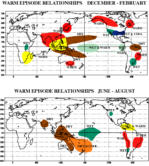
ENSO causes extreme weather (such as floods and droughts) in many regions of the world. Developing countries dependent upon agriculture and fishing, particularly those bordering the Pacific Ocean, are the most affected. In popular usage, the El Niño-Southern Oscillation is often called just "El Niño". El Niño is Spanish
Spanish language
Spanish , also known as Castilian , is a Romance language in the Ibero-Romance group that evolved from several languages and dialects in central-northern Iberia around the 9th century and gradually spread with the expansion of the Kingdom of Castile into central and southern Iberia during the...
for "the little boy" and refers to the Christ child
Child Jesus
The Child Jesus represents Jesus from his Nativity to age 12. At 13 he was considered to be adult, in accordance with the Jewish custom of his time, and that of most Christian cultures until recent centuries.The Child Jesus is frequently depicted in art, from around the third or fourth century...
, because periodic warming in the Pacific near South America
South America
South America is a continent situated in the Western Hemisphere, mostly in the Southern Hemisphere, with a relatively small portion in the Northern Hemisphere. The continent is also considered a subcontinent of the Americas. It is bordered on the west by the Pacific Ocean and on the north and east...
is usually noticed around Christmas
Christmas
Christmas or Christmas Day is an annual holiday generally celebrated on December 25 by billions of people around the world. It is a Christian feast that commemorates the birth of Jesus Christ, liturgically closing the Advent season and initiating the season of Christmastide, which lasts twelve days...
.
Definition
El Niño is defined by prolonged differences in Pacific Ocean surface temperatures when compared with the average value. The accepted definition is a warming or cooling of at least 0.5 °C (0.9 °F) averaged over the east-central tropical Pacific Ocean. Typically, this anomaly happens at irregular intervals of 2–7 years and lasts nine months to two years. The average period length is 5 years. When this warming or cooling occurs for only seven to nine months, it is classified as El Niño/La NiñaLa Niña
La Niña is a coupled ocean-atmosphere phenomenon that is the counterpart of El Niño as part of the broader El Niño-Southern Oscillation climate pattern. During a period of La Niña, the sea surface temperature across the equatorial Eastern Central Pacific Ocean will be lower than normal by 3–5 °C...
"conditions"; when it occurs for more than that period, it is classified as El Niño/La Niña "episodes".
The first signs of an El Niño are:
- Rise in surface pressurePressurePressure is the force per unit area applied in a direction perpendicular to the surface of an object. Gauge pressure is the pressure relative to the local atmospheric or ambient pressure.- Definition :...
over the Indian OceanIndian OceanThe Indian Ocean is the third largest of the world's oceanic divisions, covering approximately 20% of the water on the Earth's surface. It is bounded on the north by the Indian Subcontinent and Arabian Peninsula ; on the west by eastern Africa; on the east by Indochina, the Sunda Islands, and...
, IndonesiaIndonesiaIndonesia , officially the Republic of Indonesia , is a country in Southeast Asia and Oceania. Indonesia is an archipelago comprising approximately 13,000 islands. It has 33 provinces with over 238 million people, and is the world's fourth most populous country. Indonesia is a republic, with an...
, and AustraliaAustraliaAustralia , officially the Commonwealth of Australia, is a country in the Southern Hemisphere comprising the mainland of the Australian continent, the island of Tasmania, and numerous smaller islands in the Indian and Pacific Oceans. It is the world's sixth-largest country by total area... - Fall in air pressure over Tahiti and the rest of the central and eastern Pacific OceanPacific OceanThe Pacific Ocean is the largest of the Earth's oceanic divisions. It extends from the Arctic in the north to the Southern Ocean in the south, bounded by Asia and Australia in the west, and the Americas in the east.At 165.2 million square kilometres in area, this largest division of the World...
- Trade windTrade windThe trade winds are the prevailing pattern of easterly surface winds found in the tropics, within the lower portion of the Earth's atmosphere, in the lower section of the troposphere near the Earth's equator...
s in the south Pacific weaken or head east - Warm air rises near PeruPeruPeru , officially the Republic of Peru , is a country in western South America. It is bordered on the north by Ecuador and Colombia, on the east by Brazil, on the southeast by Bolivia, on the south by Chile, and on the west by the Pacific Ocean....
, causing rain in the northern Peruvian deserts - Warm water spreads from the west Pacific and the Indian OceanIndian OceanThe Indian Ocean is the third largest of the world's oceanic divisions, covering approximately 20% of the water on the Earth's surface. It is bounded on the north by the Indian Subcontinent and Arabian Peninsula ; on the west by eastern Africa; on the east by Indochina, the Sunda Islands, and...
to the east Pacific. It takes the rain with it, causing extensive drought in the western Pacific and rainfall in the normally dry eastern Pacific.
El Niño's warm rush of nutrient-poor tropical water, heated by its eastward passage in the Equatorial Current, replaces the cold, nutrient-rich surface water of the Humboldt Current
Humboldt Current
The Humboldt Current , also known as the Peru Current, is a cold, low-salinity ocean current that flows north-westward along the west coast of South America from the southern tip of Chile to northern Peru. It is an eastern boundary current flowing in the direction of the equator, and can extend...
. When El Niño conditions last for many months, extensive ocean warming and the reduction in Easterly Trade winds limits upwelling of cold nutrient-rich deep water and its economic impact to local fishing for an international market can be serious.
Early stages and characteristics of El Niño
Trade wind
The trade winds are the prevailing pattern of easterly surface winds found in the tropics, within the lower portion of the Earth's atmosphere, in the lower section of the troposphere near the Earth's equator...
s, part of the Walker circulation
Walker circulation
The Walker circulation, also known as the Walker cell, is a conceptual model of the air flow in the tropics in the lower atmosphere . According to this model parcels of air follow a closed circulation in the zonal and vertical directions...
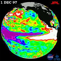
, falter for many months. A series of Kelvin waves—relatively warm subsurface waves of water a few centimetres high and hundreds of kilometres wide—cross the Pacific along the equator and create a pool of warm water near South America, where ocean temperatures are normally cold due to upwelling
Upwelling
Upwelling is an oceanographic phenomenon that involves wind-driven motion of dense, cooler, and usually nutrient-rich water towards the ocean surface, replacing the warmer, usually nutrient-depleted surface water. The increased availability in upwelling regions results in high levels of primary...
. The weakening of the winds can also create twin cyclones, another sign of a future El Niño. The Pacific Ocean is a heat reservoir
Heat sink
A heat sink is a term for a component or assembly that transfers heat generated within a solid material to a fluid medium, such as air or a liquid. Examples of heat sinks are the heat exchangers used in refrigeration and air conditioning systems and the radiator in a car...
that drives global wind patterns
Atmospheric circulation
Atmospheric circulation is the large-scale movement of air, and the means by which thermal energy is distributed on the surface of the Earth....
, and the resulting change in its temperature alters weather on a global scale. Rainfall shifts from the western Pacific toward the Americas, while Indonesia and India become drier.
Jacob Bjerknes
Jacob Bjerknes
Jacob Aall Bonnevie Bjerknes was a Norwegian-American meteorologist. -Background:Jacob Aall Bonnevie Bjerknes was born in Stockholm, Sweden. His father was the Norwegian meteorologist Vilhelm Bjerknes, one of the pioneers of modern weather forecasting. His paternal grandfather was noted...
in 1969 contributed to an understanding of ENSO by suggesting that an anomalously warm spot in the eastern Pacific can weaken the east-west temperature difference, disrupting trade winds that push warm water to the west. The result is increasingly warm water toward the east. Several mechanisms have been proposed through which warmth builds up in equatorial Pacific surface waters, and is then dispersed to lower depths by an El Niño event. The resulting cooler area then has to "recharge" warmth for several years before another event can take place.
While not a direct cause of El Niño, the Madden-Julian Oscillation
Madden-Julian oscillation
The Madden–Julian oscillation ' is the largest element of the intraseasonal variability in the tropical atmosphere. It is a large-scale coupling between atmospheric circulation and tropical deep convection...
, or MJO, propagates rainfall anomalies eastward around the global tropics in a cycle of 30–60 days, and may influence the speed of development and intensity of El Niño and La Niña in several ways. For example, westerly flows between MJO-induced areas of low pressure may cause cyclonic circulations north and south of the equator. When the circulations intensify, the westerly winds within the equatorial Pacific can further increase and shift eastward, playing a role in El Niño development. Madden-Julian activity can also produce eastward-propagating oceanic Kelvin wave
Kelvin wave
A Kelvin wave is a wave in the ocean or atmosphere that balances the Earth's Coriolis force against a topographic boundary such as a coastline, or a waveguide such as the equator. A feature of a Kelvin wave is that it is non-dispersive, i.e., the phase speed of the wave crests is equal to the...
s, which may in turn be influenced by a developing El Niño, leading to a positive feedback loop
Positive feedback
Positive feedback is a process in which the effects of a small disturbance on a system include an increase in the magnitude of the perturbation. That is, A produces more of B which in turn produces more of A. In contrast, a system that responds to a perturbation in a way that reduces its effect is...
.
Southern Oscillation

Pacific Ocean
The Pacific Ocean is the largest of the Earth's oceanic divisions. It extends from the Arctic in the north to the Southern Ocean in the south, bounded by Asia and Australia in the west, and the Americas in the east.At 165.2 million square kilometres in area, this largest division of the World...
waters. The strength of the Southern Oscillation is measured by the Southern Oscillation Index (SOI). The SOI is computed from fluctuations in the surface air pressure difference between Tahiti
Tahiti
Tahiti is the largest island in the Windward group of French Polynesia, located in the archipelago of the Society Islands in the southern Pacific Ocean. It is the economic, cultural and political centre of French Polynesia. The island was formed from volcanic activity and is high and mountainous...
and Darwin, Australia
Darwin, Northern Territory
Darwin is the capital city of the Northern Territory, Australia. Situated on the Timor Sea, Darwin has a population of 127,500, making it by far the largest and most populated city in the sparsely populated Northern Territory, but the least populous of all Australia's capital cities...
. El Niño episodes are associated with negative values of the SOI, meaning that the pressure difference between Tahiti and Darwin is relatively small.
High atmospheric pressure tends to occur over warm water and Low pressure occurs over cold water, in part because deep convection over the warm water acts to transport air. El Niño episodes are defined as sustained warming of the central and eastern tropical Pacific Ocean. This results in a decrease in the strength of the Pacific trade winds, and a reduction in rainfall over eastern and northern Australia.
Walker circulation


Walker circulation
The Walker circulation, also known as the Walker cell, is a conceptual model of the air flow in the tropics in the lower atmosphere . According to this model parcels of air follow a closed circulation in the zonal and vertical directions...
is seen at the surface as easterly trade winds that move water and air warmed by the sun toward the west. This also creates ocean upwelling
Upwelling
Upwelling is an oceanographic phenomenon that involves wind-driven motion of dense, cooler, and usually nutrient-rich water towards the ocean surface, replacing the warmer, usually nutrient-depleted surface water. The increased availability in upwelling regions results in high levels of primary...
off the coasts of Peru
Peru
Peru , officially the Republic of Peru , is a country in western South America. It is bordered on the north by Ecuador and Colombia, on the east by Brazil, on the southeast by Bolivia, on the south by Chile, and on the west by the Pacific Ocean....
and Ecuador
Ecuador
Ecuador , officially the Republic of Ecuador is a representative democratic republic in South America, bordered by Colombia on the north, Peru on the east and south, and by the Pacific Ocean to the west. It is one of only two countries in South America, along with Chile, that do not have a border...
and brings nutrient-rich cold water to the surface, increasing fishing stocks. The western side of the equatorial Pacific is characterized by warm, wet low pressure weather as the collected moisture is dumped in the form of typhoons and thunderstorms. The ocean is some 60 centimetres (23.6 in) higher in the western Pacific as the result of this motion.
North America
Winters, during the El Niño effect, are warmer and drier than average in the Northwest, Northmidwest, and Northmideast United States, and therefore those regions experience reduced snowfalls. Meanwhile, significantly wetter winters are present in northwest Mexico
Mexico
The United Mexican States , commonly known as Mexico , is a federal constitutional republic in North America. It is bordered on the north by the United States; on the south and west by the Pacific Ocean; on the southeast by Guatemala, Belize, and the Caribbean Sea; and on the east by the Gulf of...
and the southwest United States including central and southern California
California
California is a state located on the West Coast of the United States. It is by far the most populous U.S. state, and the third-largest by land area...
, while both cooler and wetter than average winters in northeast Mexico and the southeast United States (including the Tidewater region of Virginia
Tidewater region of Virginia
The Tidewater region of Virginia is the eastern portion of the Commonwealth of Virginia formally known as Hampton Roads. The term tidewater may be correctly applied to all portions of any area, including Virginia, where the water level is affected by the tides...
) occur during the El Niño phase of the oscillation.
In Canada, both warmer and drier winters (due to forcing of the Polar Jet
Jet stream
Jet streams are fast flowing, narrow air currents found in the atmospheres of some planets, including Earth. The main jet streams are located near the tropopause, the transition between the troposphere and the stratosphere . The major jet streams on Earth are westerly winds...
further north) over much of the country occur, although less variation from normal is seen in the Maritime Provinces. The following summer is warmer and sometimes drier creating a more active than average forest fire season over Central/Eastern Canada. Some believed that the ice-storm in January 1998
North American ice storm of 1998
The North American ice storm of 1998 was a massive combination of five smaller successive ice storms which combined to strike a relatively narrow swath of land from eastern Ontario to southern Quebec to Nova Scotia in Canada, and bordering areas from northern New York to central Maine in the...
, which devastated parts of Southern Ontario and Southern Quebec, was caused or accentuated by El Niño's warming effects. El Niño warmed Vancouver
Vancouver
Vancouver is a coastal seaport city on the mainland of British Columbia, Canada. It is the hub of Greater Vancouver, which, with over 2.3 million residents, is the third most populous metropolitan area in the country,...
for the 2010 Winter Olympics
2010 Winter Olympics
The 2010 Winter Olympics, officially the XXI Olympic Winter Games or the 21st Winter Olympics, were a major international multi-sport event held from February 12–28, 2010, in Vancouver, British Columbia, Canada, with some events held in the suburbs of Richmond, West Vancouver and the University...
, such that the area experienced a subtropical-like winter during the games.
Summers, during the El Niño effect, are wetter than average in the Northwest, Northmidwest, Northmideast, and mountain regions of the United States.
El Niño is credited with suppressing hurricanes and made the 2009 hurricane season the least active in twelve years. El Niño is also associated with increased wave-caused coastal erosion along the United States Pacific Coast.
There is some evidence that El Niño activity is correlated with incidence of red tide
Red tide
Red tide is a common name for a phenomenon also known as an algal bloom , an event in which estuarine, marine, or fresh water algae accumulate rapidly in the water column and results in discoloration of the surface water. It is usually found in coastal areas...
s off the Pacific coast of California.
Tropical cyclones
Most tropical cyclones form on the side of the subtropical ridge closer to the equatorEquator
An equator is the intersection of a sphere's surface with the plane perpendicular to the sphere's axis of rotation and containing the sphere's center of mass....
, then move poleward past the ridge axis before recurving into the main belt of the Westerlies
Westerlies
The Westerlies, anti-trades, or Prevailing Westerlies, are the prevailing winds in the middle latitudes between 30 and 60 degrees latitude, blowing from the high pressure area in the horse latitudes towards the poles. These prevailing winds blow from the west to the east, and steer extratropical...
. When the subtropical ridge
Subtropical ridge
The subtropical ridge is a significant belt of high pressure situated around the latitudes of 30°N in the Northern Hemisphere and 30°S in the Southern Hemisphere. It is characterized by mostly calm winds, which acts to reduce air quality under its axis by causing fog overnight, and haze during...
position shifts due to El Niño, so will the preferred tropical cyclone tracks. Areas west of Japan
Japan
Japan is an island nation in East Asia. Located in the Pacific Ocean, it lies to the east of the Sea of Japan, China, North Korea, South Korea and Russia, stretching from the Sea of Okhotsk in the north to the East China Sea and Taiwan in the south...
and Korea
Korea
Korea ) is an East Asian geographic region that is currently divided into two separate sovereign states — North Korea and South Korea. Located on the Korean Peninsula, Korea is bordered by the People's Republic of China to the northwest, Russia to the northeast, and is separated from Japan to the...
tend to experience much fewer September–November tropical cyclone impacts during El Niño and neutral years. During El Niño years, the break in the subtropical ridge tends to lie near 130°E
130th meridian east
The meridian 130° east of Greenwich is a line of longitude that extends from the North Pole across the Arctic Ocean, Asia, Australia, the Indian Ocean, the Southern Ocean, and Antarctica to the South Pole....
, which would favor the Japanese archipelago. During El Niño years, Guam
Guam
Guam is an organized, unincorporated territory of the United States located in the western Pacific Ocean. It is one of five U.S. territories with an established civilian government. Guam is listed as one of 16 Non-Self-Governing Territories by the Special Committee on Decolonization of the United...
's chance of a tropical cyclone impact is one-third of the long term average. The tropical Atlantic ocean experiences depressed activity due to increased vertical wind shear
Wind shear
Wind shear, sometimes referred to as windshear or wind gradient, is a difference in wind speed and direction over a relatively short distance in the atmosphere...
across the region during El Niño years.
Elsewhere
In Africa, East AfricaEast Africa
East Africa or Eastern Africa is the easterly region of the African continent, variably defined by geography or geopolitics. In the UN scheme of geographic regions, 19 territories constitute Eastern Africa:...
- including Kenya
Kenya
Kenya , officially known as the Republic of Kenya, is a country in East Africa that lies on the equator, with the Indian Ocean to its south-east...
, Tanzania
Tanzania
The United Republic of Tanzania is a country in East Africa bordered by Kenya and Uganda to the north, Rwanda, Burundi, and the Democratic Republic of the Congo to the west, and Zambia, Malawi, and Mozambique to the south. The country's eastern borders lie on the Indian Ocean.Tanzania is a state...
, and the White Nile
White Nile
The White Nile is a river of Africa, one of the two main tributaries of the Nile from Egypt, the other being the Blue Nile. In the strict meaning, "White Nile" refers to the river formed at Lake No at the confluence of the Bahr al Jabal and Bahr el Ghazal rivers...
basin - experiences, in the long rains from March to May, wetter-than-normal conditions. There are also drier than normal conditions from December to February in south-central Africa, mainly in Zambia
Zambia
Zambia , officially the Republic of Zambia, is a landlocked country in Southern Africa. The neighbouring countries are the Democratic Republic of the Congo to the north, Tanzania to the north-east, Malawi to the east, Mozambique, Zimbabwe, Botswana and Namibia to the south, and Angola to the west....
, Zimbabwe
Zimbabwe
Zimbabwe is a landlocked country located in the southern part of the African continent, between the Zambezi and Limpopo rivers. It is bordered by South Africa to the south, Botswana to the southwest, Zambia and a tip of Namibia to the northwest and Mozambique to the east. Zimbabwe has three...
, Mozambique
Mozambique
Mozambique, officially the Republic of Mozambique , is a country in southeastern Africa bordered by the Indian Ocean to the east, Tanzania to the north, Malawi and Zambia to the northwest, Zimbabwe to the west and Swaziland and South Africa to the southwest...
, and Botswana
Botswana
Botswana, officially the Republic of Botswana , is a landlocked country located in Southern Africa. The citizens are referred to as "Batswana" . Formerly the British protectorate of Bechuanaland, Botswana adopted its new name after becoming independent within the Commonwealth on 30 September 1966...
.
Direct effects of El Niño resulting in drier conditions occur in parts of Southeast Asia
Southeast Asia
Southeast Asia, South-East Asia, South East Asia or Southeastern Asia is a subregion of Asia, consisting of the countries that are geographically south of China, east of India, west of New Guinea and north of Australia. The region lies on the intersection of geological plates, with heavy seismic...
and Northern Australia
Northern Australia
The term northern Australia is generally known to include two State and Territories, being Queensland and the Northern Territory . The part of Western Australia north of latitude 26° south—a definition widely used in law and State government policy—is also usually included...
, increasing bush fires, worsening haze
Haze
Haze is traditionally an atmospheric phenomenon where dust, smoke and other dry particles obscure the clarity of the sky. The World Meteorological Organization manual of codes includes a classification of horizontal obscuration into categories of fog, ice fog, steam fog, mist, haze, smoke, volcanic...
, and decreasing air quality dramatically. Drier-than-normal conditions are also in general observed in Queensland
Queensland
Queensland is a state of Australia, occupying the north-eastern section of the mainland continent. It is bordered by the Northern Territory, South Australia and New South Wales to the west, south-west and south respectively. To the east, Queensland is bordered by the Coral Sea and Pacific Ocean...
, inland Victoria
Victoria (Australia)
Victoria is the second most populous state in Australia. Geographically the smallest mainland state, Victoria is bordered by New South Wales, South Australia, and Tasmania on Boundary Islet to the north, west and south respectively....
, inland New South Wales
New South Wales
New South Wales is a state of :Australia, located in the east of the country. It is bordered by Queensland, Victoria and South Australia to the north, south and west respectively. To the east, the state is bordered by the Tasman Sea, which forms part of the Pacific Ocean. New South Wales...
, and eastern Tasmania
Tasmania
Tasmania is an Australian island and state. It is south of the continent, separated by Bass Strait. The state includes the island of Tasmania—the 26th largest island in the world—and the surrounding islands. The state has a population of 507,626 , of whom almost half reside in the greater Hobart...
from June to August.
Many ENSO linkages exist in the high southern latitudes around Antarctica . Specifically, El Niño conditions result in high pressure
High pressure area
A high-pressure area is a region where the atmospheric pressure at the surface of the planet is greater than its surrounding environment. Winds within high-pressure areas flow outward due to the higher density air near their center and friction with land...
anomalies over the Amundsen
Amundsen Sea
The Amundsen Sea is an arm of the Southern Ocean off Marie Byrd Land in western Antarctica. It is bounded by Cape Flying Fish, the northwestern tip of Thurston Island to the east and Cape Dart on Siple Island to the west. East of Cape Flying Fish starts the Bellingshausen Sea. West of Cape Dart is...
and Bellingshausen
Bellingshausen Sea
The Bellingshausen Sea is an area along the west side of the Antarctic Peninsula, west of Alexander Island, east of Cape Flying Fish on Thurston Island, and south of Peter I Island . In the south are, from west to east, Eights Coast, Bryan Coast and English Coast of West Antarctica...
seas, causing reduced sea ice
Sea ice
Sea ice is largely formed from seawater that freezes. Because the oceans consist of saltwater, this occurs below the freezing point of pure water, at about -1.8 °C ....
and increased poleward heat fluxes in these sectors as well as the Ross Sea
Ross Sea
The Ross Sea is a deep bay of the Southern Ocean in Antarctica between Victoria Land and Marie Byrd Land.-Description:The Ross Sea was discovered by James Ross in 1841. In the west of the Ross Sea is Ross Island with the Mt. Erebus volcano, in the east Roosevelt Island. The southern part is covered...
. The Weddell Sea
Weddell Sea
The Weddell Sea is part of the Southern Ocean and contains the Weddell Gyre. Its land boundaries are defined by the bay formed from the coasts of Coats Land and the Antarctic Peninsula. The easternmost point is Cape Norvegia at Princess Martha Coast, Queen Maud Land. To the east of Cape Norvegia is...
, conversely, tends to become colder with more sea ice during El Niño. The exact opposite heating and atmospheric pressure anomalies occur during La Niña .
El Niño's effects on Europe
Europe
Europe is, by convention, one of the world's seven continents. Comprising the westernmost peninsula of Eurasia, Europe is generally 'divided' from Asia to its east by the watershed divides of the Ural and Caucasus Mountains, the Ural River, the Caspian and Black Seas, and the waterways connecting...
are not entirely clear, but it is not nearly as affected as at least large parts of other continents. There is some evidence that an El Niño may cause a wetter, cloudier winter in Northern Europe and a milder, drier winter in the Mediterranean Sea region. The El Niño winter of 2006/2007 was unusually mild in Europe, and the Alps recorded very little snow coverage that season.
In most recent times, Singapore experienced the driest February in 2010 since records begins in 1869. With only 6.3 millimetres of rain fell in the month and temperatures hitting as high as 35 degrees Celsius on 26 February. The years 1968 and 2005 had the next driest Februaries, when 8.4 mm of rain fell.
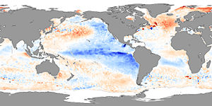
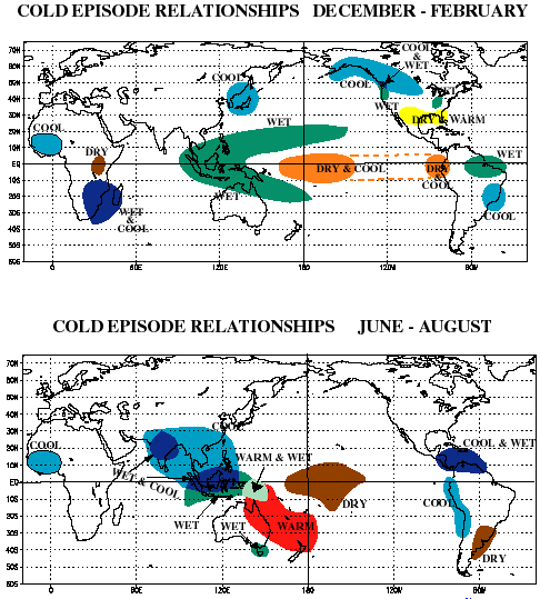
Effects of ENSO's cool phase (La Niña)
Spanish language
Spanish , also known as Castilian , is a Romance language in the Ibero-Romance group that evolved from several languages and dialects in central-northern Iberia around the 9th century and gradually spread with the expansion of the Kingdom of Castile into central and southern Iberia during the...
, meaning "the girl", analogous to El Niño meaning "the boy". It has also in the past been called anti-El Niño, and El Viejo (meaning "the old man").
Africa
La Niña results in wetter-than-normal conditions in Southern Africa from December to February, and drier-than-normal conditions over equatorial East Africa over the same period.Asia
During La Niña years, the formation of tropical cyclones, along with the subtropical ridge position, shifts westward across the western Pacific ocean, which increases the landfall threat to ChinaChina
Chinese civilization may refer to:* China for more general discussion of the country.* Chinese culture* Greater China, the transnational community of ethnic Chinese.* History of China* Sinosphere, the area historically affected by Chinese culture...
. In March 2008, La Niña caused a drop in sea surface temperatures over Southeast Asia by an amount of 2 °C. It also caused heavy rains over Malaysia, Philippines
Philippines
The Philippines , officially known as the Republic of the Philippines , is a country in Southeast Asia in the western Pacific Ocean. To its north across the Luzon Strait lies Taiwan. West across the South China Sea sits Vietnam...
, and Indonesia
Indonesia
Indonesia , officially the Republic of Indonesia , is a country in Southeast Asia and Oceania. Indonesia is an archipelago comprising approximately 13,000 islands. It has 33 provinces with over 238 million people, and is the world's fourth most populous country. Indonesia is a republic, with an...
.
South America
During a time of La Niña, drought plagues the coastal regions of Peru and Chile. From December to February, northern Brazil is wetter than normal.North America
Precipitation (meteorology)
In meteorology, precipitation In meteorology, precipitation In meteorology, precipitation (also known as one of the classes of hydrometeors, which are atmospheric water phenomena is any product of the condensation of atmospheric water vapor that falls under gravity. The main forms of precipitation...
across the North Midwest, the Northern Rockies, Northern California, and the Pacific Northwest's southern and eastern regions. Meanwhile there is below-average precipitation in the southwestern and southeastern states.
La Niñas occurred in 1904, 1908, 1910, 1916, 1924, 1928, 1938, 1950, 1955, 1964, 1970, 1973, 1975, 1988, 1995.
In Canada, La Niña will in general cause a cooler, snowier winter, such as the near record-breaking amounts of snow recorded in the La Niña winter of 2007/2008 in Eastern Canada.
ile:Example.jpwinter.
The 2010-2011 La Niña was one of the strongest ever observed. The effect on Eastern Australia was devastating.
Remote influence on tropical Atlantic Ocean
A study of climate records has shown that El Niño events in the equatorial Pacific are generally associated with a warm tropical North Atlantic in the following spring and summer. About half of El Niño events persist sufficiently into the spring months for the Western Hemisphere Warm PoolWestern Hemisphere Warm Pool
The Western Hemisphere Warm Pool is a region of sea surface temperatures warmer than 28.5°C that develops west of Central America in the spring, then expands to the tropical waters to the east....
(WHWP) to become unusually large in summer. Occasionally, El Niño's effect on the Atlantic Walker circulation over South America strengthens the easterly trade winds in the western equatorial Atlantic region. As a result, an unusual cooling may occur in the eastern equatorial Atlantic in spring and summer following El Niño peaks in winter. Cases of El Niño-type events in both oceans simultaneously have been linked to severe famine
Famine
A famine is a widespread scarcity of food, caused by several factors including crop failure, overpopulation, or government policies. This phenomenon is usually accompanied or followed by regional malnutrition, starvation, epidemic, and increased mortality. Every continent in the world has...
s related to the extended failure of monsoon
Monsoon
Monsoon is traditionally defined as a seasonal reversing wind accompanied by corresponding changes in precipitation, but is now used to describe seasonal changes in atmospheric circulation and precipitation associated with the asymmetric heating of land and sea...
rains.
ENSO and global warming
During the last several decades the number of El Niño events increased, and the number of La Niña events decreased. The question is whether this is a random fluctuation or a normal instance of variation for that phenomenon or the result of global climate changes toward global warmingGlobal warming
Global warming refers to the rising average temperature of Earth's atmosphere and oceans and its projected continuation. In the last 100 years, Earth's average surface temperature increased by about with about two thirds of the increase occurring over just the last three decades...
.
The studies of historical data show that the recent El Niño variation is most likely linked to global warming. For example, one of the most recent results is that, even after subtracting the positive influence of decadal variation, shown to be possibly present in the ENSO trend, the amplitude of the ENSO variability in the observed data still increases, by as much as 60% in the last 50 years.
It is not certain what exact changes will happen to ENSO in the future: Different models make different predictions (cf.) It may be that the observed phenomenon of more frequent and stronger El Niño events occurs only in the initial phase of the global warming, and then (e.g., after the lower layers of the ocean get warmer as well), El Niño will become weaker than it was. It may also be that the stabilizing and destabilizing forces influencing the phenomenon will eventually compensate for each other. More research is needed to provide a better answer to that question, but the current results do not completely exclude the possibility of dramatic changes. The ENSO is considered to be a potential tipping element
Tipping point (climatology)
A climate tipping point is a point when global climate changes from one stable state to another stable state, in a similar manner to a wine glass tipping over. After the tipping point has been passed, a transition to a new state occurs...
in Earth's climate.
El Niño "Modoki" and Central-Pacific El Niño

Japanese language
is a language spoken by over 130 million people in Japan and in Japanese emigrant communities. It is a member of the Japonic language family, which has a number of proposed relationships with other languages, none of which has gained wide acceptance among historical linguists .Japanese is an...
for "similar, but different").
The effects of the CP El Niño are different from those of the traditional EP El Niño — e.g., the new El Niño leads to more hurricanes more frequently making landfall in the Atlantic.
The recent discovery of El Niño Modoki has some scientists believing it to be linked to global warming. However, Satellite data goes back only to 1979. More research must be done to find the correlation and study past El Niño episodes.
The first recorded El Niño that originated in the central Pacific and moved toward the east was in 1986.
A joint study by the National Aeronautics and Space Administration and the National Oceanic and Atmospheric Administration
National Oceanic and Atmospheric Administration
The National Oceanic and Atmospheric Administration , pronounced , like "noah", is a scientific agency within the United States Department of Commerce focused on the conditions of the oceans and the atmosphere...
concluded that climate change
Climate change
Climate change is a significant and lasting change in the statistical distribution of weather patterns over periods ranging from decades to millions of years. It may be a change in average weather conditions or the distribution of events around that average...
may contribute to stronger El Niños. El Niño "Modoki" events occurred in 1991-92, 1994–95, 2002–03, 2004–05, and 2009-10. The strongest such Central Pacific El Niño event known occurred in 2009-2010.
Health and social impacts of El Niño
Extreme weather conditions related to the El Niño cycle correlate with changes in the incidence of epidemicEpidemic
In epidemiology, an epidemic , occurs when new cases of a certain disease, in a given human population, and during a given period, substantially exceed what is expected based on recent experience...
diseases. For example, the El Niño cycle is associated with increased risks of some of the diseases transmitted by mosquitoes, such as malaria
Malaria
Malaria is a mosquito-borne infectious disease of humans and other animals caused by eukaryotic protists of the genus Plasmodium. The disease results from the multiplication of Plasmodium parasites within red blood cells, causing symptoms that typically include fever and headache, in severe cases...
, dengue, and Rift Valley fever
Rift Valley fever
Rift Valley Fever is a viral zoonosis causing fever. It is spread by the bite of infected mosquitoes, typically the Aedes or Culex genera. The disease is caused by the RVF virus, a member of the genus Phlebovirus...
. Cycles of malaria in India
India
India , officially the Republic of India , is a country in South Asia. It is the seventh-largest country by geographical area, the second-most populous country with over 1.2 billion people, and the most populous democracy in the world...
, Venezuela
Venezuela
Venezuela , officially called the Bolivarian Republic of Venezuela , is a tropical country on the northern coast of South America. It borders Colombia to the west, Guyana to the east, and Brazil to the south...
, and Colombia
Colombia
Colombia, officially the Republic of Colombia , is a unitary constitutional republic comprising thirty-two departments. The country is located in northwestern South America, bordered to the east by Venezuela and Brazil; to the south by Ecuador and Peru; to the north by the Caribbean Sea; to the...
have now been linked to El Niño. Outbreaks of another mosquito-transmitted disease, Australian encephalitis ( Murray Valley encephalitis
Murray Valley encephalitis virus
Murray Valley encephalitis virus is a zoonotic flavivirus endemic to northern Australia and Papua New Guinea. It is the causal agent of Murray Valley encephalitis and in humans can cause permanent neurological disease or death...
- MVE), occur in temperate south-east Australia after heavy rainfall and flooding, which are associated with La Niña events. A severe outbreak of Rift Valley fever occurred after extreme rainfall in north-eastern Kenya and southern Somalia during the 1997-98 El Niño.
ENSO may be linked to civil conflicts. Scientists at the Earth Institute of Columbia University have analyzed data from 1950 to 2004 and suggest that ENSO may have had a role in 21% of all civil conflicts since 1950, with the risk of annual civil conflict doubling from 3% to 6% in countries affected by ENSO during El Niño years relative to La Niña years.
Cultural history and pre-historic information

Holocene
The Holocene is a geological epoch which began at the end of the Pleistocene and continues to the present. The Holocene is part of the Quaternary period. Its name comes from the Greek words and , meaning "entirely recent"...
epoch 10,000 years ago.
El Niño affected pre-Columbian
Pre-Columbian
The pre-Columbian era incorporates all period subdivisions in the history and prehistory of the Americas before the appearance of significant European influences on the American continents, spanning the time of the original settlement in the Upper Paleolithic period to European colonization during...
Incas and may have led to the demise of the Moche
Moche
'The Moche civilization flourished in northern Peru from about 100 AD to 800 AD, during the Regional Development Epoch. While this issue is the subject of some debate, many scholars contend that the Moche were not politically organized as a monolithic empire or state...
and other pre-Columbian Peruvian cultures
Cultural periods of Peru
This is a chart of cultural periods of Peru and the Andean Region developed by Edward Lanning and used by some archaeologists studying the area...
. A recent study suggests that a strong El-Niño effect between 1789–93 caused poor crop yields in Europe, which in turn helped touch off the French Revolution
French Revolution
The French Revolution , sometimes distinguished as the 'Great French Revolution' , was a period of radical social and political upheaval in France and Europe. The absolute monarchy that had ruled France for centuries collapsed in three years...
. The extreme weather produced by El Niño in 1876–77 gave rise to the most deadly famine
Famine
A famine is a widespread scarcity of food, caused by several factors including crop failure, overpopulation, or government policies. This phenomenon is usually accompanied or followed by regional malnutrition, starvation, epidemic, and increased mortality. Every continent in the world has...
s of the 19th century.
An early recorded mention of the term "El Niño" to refer to climate occurs in 1892, when Captain Camilo Carrillo told the Geographical society congress in Lima
Lima
Lima is the capital and the largest city of Peru. It is located in the valleys of the Chillón, Rímac and Lurín rivers, in the central part of the country, on a desert coast overlooking the Pacific Ocean. Together with the seaport of Callao, it forms a contiguous urban area known as the Lima...
that Peruvian sailors named the warm northerly current "El Niño" because it was most noticeable around Christmas. The phenomenon had long been of interest because of its effects on the guano
Guano
Guano is the excrement of seabirds, cave dwelling bats, and seals. Guano manure is an effective fertilizer due to its high levels of phosphorus and nitrogen and also its lack of odor. It was an important source of nitrates for gunpowder...
industry and other enterprises that depend on biological productivity of the sea.
Charles Todd, in 1893, suggested that droughts in India and Australia tended to occur at the same time; Norman Lockyer noted the same in 1904. An El Niño connection with flooding was reported in 1895 by Pezet and Eguiguren. In 1924, Gilbert Walker
Gilbert Walker
Sir Gilbert Thomas Walker, CSI, FRS, was a British physicist and statistician of the 20th century. He is best known for his groundbreaking description of the Southern Oscillation, a major phenomenon of global climate, and for greatly advancing the study of climate in general.He was born in...
(for whom the Walker circulation
Walker circulation
The Walker circulation, also known as the Walker cell, is a conceptual model of the air flow in the tropics in the lower atmosphere . According to this model parcels of air follow a closed circulation in the zonal and vertical directions...
is named) coined the term "Southern Oscillation".
The major 1982–83 El Niño led to an upsurge of interest from the scientific community. The period from 1990–1994 was unusual in that El Niños have rarely occurred in such rapid succession. An especially intense El Niño event in 1998 caused an estimated 16% of the world's reef systems to die. The event temporarily warmed air temperature by 1.5 °C, compared to the usual increase of 0.25 °C associated with El Niño events. Since then, mass coral bleaching
Coral bleaching
Coral bleaching is the loss of intracellular endosymbionts through either expulsion or loss of algal pigmentation.The corals that form the structure of the great reef ecosystems of tropical seas depend upon a symbiotic relationship with unicellular flagellate protozoa, called zooxanthellae, that...
has become common worldwide, with all regions having suffered "severe bleaching".
Major ENSO events were recorded in the years 1790–93, 1828, 1876–78, 1891, 1925–26, 1972–73, 1982–83, and 1997–98, with 2010–2011 being one of the strongest ever.
See also
- Benguela Niño
- Indian Ocean DipoleIndian Ocean DipoleThe Indian Ocean Dipole is an irregular oscillation of sea-surface temperatures in which the western Indian Ocean becomes alternately warmer and then colder than the eastern part of the ocean.-The phenomenon:...
- Pacific Decadal OscillationPacific decadal oscillationThe Pacific Decadal Oscillation is a pattern of Pacific climate variability that shifts phases on at least inter-decadal time scale, usually about 20 to 30 years. The PDO is detected as warm or cool surface waters in the Pacific Ocean, north of 20° N...
External links
- International Research Centre on El Niño-CIIFEN
- Latest ENSO updates & predictions from the International Research Institute for Climate and Society
- PO.DAAC's El Niño Animations
- National Academy of Sciences El Niño/La Niña article
- NOAA FAQ "What is ENSO?"
- Latest El Niño/La Niña Data from NASA
- Economic Costs of El Niño / La Niña and Economic Benefits from Improved Forecasting from "NOAA Socioeconomics" website initiative
- El-Niño-Southern Oscillation
- El Niño and La Niña from the 1999 International Red Cross World Disasters Report by Eric J. Lyman.
- ENSO (El Niño-Southern Oscillation)
- La Niña episodes in the Tropical Pacific
- NOAA announces 2004 El Niño
- NOAA El Niño Page
- Ocean Motion: El Niño
- SOI (Southern Oscillation Index)
- The Climate of Peru
- What is El Niño?
- What is La Niña?
- El-Nino, La-Nina, Southern Oscillation, ENSO
- Kelvin Wave Renews El Niño - NASA, Earth Observatory image of the day, 2010, March 21
- Animation of ENSO in Victoria, Australia
Category:Tropical meteorology
Category:Physical oceanography
Category:Natural history of the Americas
Category:Natural history of Oceania
Category:Effects of global warming
Category:Climate patterns
Category:Weather hazards
Category:Spanish loanwords
ar:إل نينو
an:El Niño
az:El-Ninyo
bn:এল নিনো
zh-min-nan:El Niño
be:Эль-Ніньё
be-x-old:Эль Ніньё
bs:El Niño
br:El Niño
bg:Ел Ниньо
ca:El Niño
cs:El Niño
cy:El Niño
da:El Niño
de:El Niño-Southern Oscillation
et:El Niño
el:Ελ Νίνιο
es:El Niño
eo:El-Ninjo
eu:El niño
fa:النینیو
fr:El Niño
gl:El Niño
ko:엘니뇨
hi:एल नीनो
hr:El Niño
id:El Niño–Southern Oscillation
is:El Niño
it:El Niño
he:אל ניניו
ka:ელ-ნინიო
ht:El Niño
la:Puellus
lv:El Ninjo
lt:El Ninjo
hu:El Niño
mk:Ел Нињо
ml:എൽ നിനോ
mr:एल निन्यो
ms:El Nino
mn:Эль Нино
nl:El Niño
ja:エルニーニョ・南方振動
no:El Niño
nn:El Niño
oc:El Niño
pnb:ال نینو
pl:El Niño
pt:El Niño
ro:El Niño
qu:El Niño
ru:Эль-Ниньо
sq:El Ninjo
si:එල් නිනෝ
simple:El Niño-Southern Oscillation
sk:El Niño
sl:El Niño
sr:El Ninjo
sh:El Niño
fi:El Niño
sv:El Niño
tl:El Niño
ta:எல் நீனோ-தெற்கத்திய அலைவு
th:เอลนีโญ-ความผันแปรของระบบอากาศในซีกโลกใต้
tr:El Niño
uk:Ель-Ніньйо
vi:El Nino
fiu-vro:El Niño
war:El Niño
zh-yue:厄爾尼諾南方擺動現象
bat-smg:El Ninjo
zh:聖嬰-南方振盪現象