
Plate tectonics
Overview
Scientific theory
A scientific theory comprises a collection of concepts, including abstractions of observable phenomena expressed as quantifiable properties, together with rules that express relationships between observations of such concepts...
that describes the large scale motions of Earth
Earth
Earth is the third planet from the Sun, and the densest and fifth-largest of the eight planets in the Solar System. It is also the largest of the Solar System's four terrestrial planets...
's lithosphere
Lithosphere
The lithosphere is the rigid outermost shell of a rocky planet. On Earth, it comprises the crust and the portion of the upper mantle that behaves elastically on time scales of thousands of years or greater.- Earth's lithosphere :...
. The theory builds on the concepts of continental drift
Continental drift
Continental drift is the movement of the Earth's continents relative to each other. The hypothesis that continents 'drift' was first put forward by Abraham Ortelius in 1596 and was fully developed by Alfred Wegener in 1912...
, developed during the first decades of the 20th century, and accepted by the majority of the geoscientific community when the concepts of seafloor spreading
Seafloor spreading
Seafloor spreading is a process that occurs at mid-ocean ridges, where new oceanic crust is formed through volcanic activity and then gradually moves away from the ridge. Seafloor spreading helps explain continental drift in the theory of plate tectonics....
were developed in the late 1950s and early 1960s.
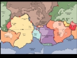
The lithosphere
Lithosphere
The lithosphere is the rigid outermost shell of a rocky planet. On Earth, it comprises the crust and the portion of the upper mantle that behaves elastically on time scales of thousands of years or greater.- Earth's lithosphere :...
is broken up into tectonic plates.
Unanswered Questions
Discussions