

Monsoon of Indian subcontinent
Encyclopedia

Monsoon
Monsoon is traditionally defined as a seasonal reversing wind accompanied by corresponding changes in precipitation, but is now used to describe seasonal changes in atmospheric circulation and precipitation associated with the asymmetric heating of land and sea...
of the India
India
India , officially the Republic of India , is a country in South Asia. It is the seventh-largest country by geographical area, the second-most populous country with over 1.2 billion people, and the most populous democracy in the world...
is among the several geographically distributed observations of the global monsoons. In the subcontinent, it is one of oldest weather observations, an economically important weather pattern and the most anticipated weather event and unique weather
Weather
Weather is the state of the atmosphere, to the degree that it is hot or cold, wet or dry, calm or stormy, clear or cloudy. Most weather phenomena occur in the troposphere, just below the stratosphere. Weather refers, generally, to day-to-day temperature and precipitation activity, whereas climate...
phenomenon
Phenomenon
A phenomenon , plural phenomena, is any observable occurrence. Phenomena are often, but not always, understood as 'appearances' or 'experiences'...
. Yet it is only partially understood and notoriously difficult to predict. Several theories have been proposed explaining the origin, the process, the strength, the variability, the distribution and the general vagaries of the Monsoon of the Indian Subcontinent, but our understanding of the phenomenon and its predictability are still evolving. The unique geographical features
Geography of India
The geography of India describes the physical features of India, a country in South Asia, that lies entirely on the Indian Plate in the northern portion of the Indo-Australian Plate. The country lies to the north of the equator between 8°4' and 37°6' north latitude and 68°7' and 97°25' east...
of the subcontinent, along with associated atmospheric, ocean
Ocean
An ocean is a major body of saline water, and a principal component of the hydrosphere. Approximately 71% of the Earth's surface is covered by ocean, a continuous body of water that is customarily divided into several principal oceans and smaller seas.More than half of this area is over 3,000...
ic and geophysical components, are extremely influential in ensuring the anticipated behavior for a Monsoon in South Asia
South Asia
South Asia, also known as Southern Asia, is the southern region of the Asian continent, which comprises the sub-Himalayan countries and, for some authorities , also includes the adjoining countries to the west and the east...
and the Indian subcontinent
Indian subcontinent
The Indian subcontinent, also Indian Subcontinent, Indo-Pak Subcontinent or South Asian Subcontinent is a region of the Asian continent on the Indian tectonic plate from the Hindu Kush or Hindu Koh, Himalayas and including the Kuen Lun and Karakoram ranges, forming a land mass which extends...
. Due to its effect on agriculture
Agriculture
Agriculture is the cultivation of animals, plants, fungi and other life forms for food, fiber, and other products used to sustain life. Agriculture was the key implement in the rise of sedentary human civilization, whereby farming of domesticated species created food surpluses that nurtured the...
, flora and fauna and the general weather of India
India
India , officially the Republic of India , is a country in South Asia. It is the seventh-largest country by geographical area, the second-most populous country with over 1.2 billion people, and the most populous democracy in the world...
, Bangladesh
Bangladesh
Bangladesh , officially the People's Republic of Bangladesh is a sovereign state located in South Asia. It is bordered by India on all sides except for a small border with Burma to the far southeast and by the Bay of Bengal to the south...
, Pakistan
Pakistan
Pakistan , officially the Islamic Republic of Pakistan is a sovereign state in South Asia. It has a coastline along the Arabian Sea and the Gulf of Oman in the south and is bordered by Afghanistan and Iran in the west, India in the east and China in the far northeast. In the north, Tajikistan...
, Sri Lanka
Sri Lanka
Sri Lanka, officially the Democratic Socialist Republic of Sri Lanka is a country off the southern coast of the Indian subcontinent. Known until 1972 as Ceylon , Sri Lanka is an island surrounded by the Indian Ocean, the Gulf of Mannar and the Palk Strait, and lies in the vicinity of India and the...
, etc., among other economic, social
Social
The term social refers to a characteristic of living organisms...
and environmental
Natural environment
The natural environment encompasses all living and non-living things occurring naturally on Earth or some region thereof. It is an environment that encompasses the interaction of all living species....
effects, a Monsoon is one of the most anticipated, followed and studied weather phenomenons of the Indian subcontinent. It has significant impact on the overall well-being of sub-continent residents and has even been dubbed the"real finance minister of India".
Definition
Monsoon, although generally defined as a system of windsWINDS
WINDS , is a Japanese communication satellite. Launch was originally scheduled for 2007. The launch date was eventually set for 15 February 2008, however a problem detected in a second stage manoeuvring thruster delayed it to 23 February...
characterized by a seasonal reversal of its direction, lacks a consistent detailed definition. Some examples are given below:
- The American Meteorological Society defines it as a name for seasonal winds, first applied to the winds blowing over the Arabian Sea from northeast for six months and southwest for six months. Later it has been extended to similar winds in other parts of the world.
- Intergovernmental Panel on Climate ChangeIntergovernmental Panel on Climate ChangeThe Intergovernmental Panel on Climate Change is a scientific intergovernmental body which provides comprehensive assessments of current scientific, technical and socio-economic information worldwide about the risk of climate change caused by human activity, its potential environmental and...
(IPCC) describes Monsoon as a tropical and subtropical seasonal reversal in both the surface winds and associated precipitationPrecipitation (meteorology)In meteorology, precipitation In meteorology, precipitation In meteorology, precipitation (also known as one of the classes of hydrometeors, which are atmospheric water phenomena is any product of the condensation of atmospheric water vapor that falls under gravity. The main forms of precipitation...
, caused by differential heating between a continental-scale land mass and the adjacent ocean. - Indian Meteorological Department defines it as the seasonal reversals of the wind direction along the shores of the Indian Ocean, especially in the Arabian Sea, that blow from the southwest during one half of the year and from the northeast during the other half.
- Colin Stokes Ramage in Monsoon Meteorology, International Geophysics Series, Vol. 15, defines Monsoon as a seasonal reversing wind accompanied by corresponding changes in precipitation.
Monsoon of the subcontinent is primarily noted for its rain bearing ability and for the associated unpredictability of the weather. Consequently some definitions incorporate rain in its definition.
Background
Observed initially by sailors in the Arabian sea traveling between Africa, India and South-East Asia, Monsoon is a major weather phenomenon in India (and the subcontinent) for the influence it casts on the lives of its inhabitants since centuries.Monsoon in India can be categorized into two branches based on their spatial spread over the sub-continent:
- Arabian Sea Branch
- Bay of Bengal Branch
- South-West Monsoon (SW Monsoon)
- North-East Monsoon (NE Monsoon)The name of the wind is based on the direction that it blows from. Therefore, South-West winds imply that the winds are blowing onto the land from the South-West direction. Similarly North-East wind implies air flowing from north east towards south-west onto the land
Based on the time of the year that these winds bring rain
Rain
Rain is liquid precipitation, as opposed to non-liquid kinds of precipitation such as snow, hail and sleet. Rain requires the presence of a thick layer of the atmosphere to have temperatures above the melting point of water near and above the Earth's surface...
to India, they can also be categorised in two rain periods called:
- the Summer monsoon (June to September)
- the Winter monsoon, (October to December)
The complexity of Monsoon as a weather phenomenon of India is not yet completely understood, making it difficult to accurately predict its behavior in terms of quantity, temporal and spatial distribution of the accompanying precipitation. These are the most monitored components of Monsoon determining the water availability in India for any given year.
Mechanism of Monsoon
Monsoon is a tropical phenomenon. Indian subcontinent, lying northwards of the equator up to the HimalayasHimalayas
The Himalaya Range or Himalaya Mountains Sanskrit: Devanagari: हिमालय, literally "abode of snow"), usually called the Himalayas or Himalaya for short, is a mountain range in Asia, separating the Indian subcontinent from the Tibetan Plateau...
and Hindukush, lies primarily in the tropical zone of the Northern Hemisphere
Northern Hemisphere
The Northern Hemisphere is the half of a planet that is north of its equator—the word hemisphere literally means “half sphere”. It is also that half of the celestial sphere north of the celestial equator...
.
It involves winds blowing from the south-west direction (known as South-West Monsoon) from the Indian Ocean onto the Indian landmass during the months of June through September. These are generally rain-bearing winds, blowing from sea to land, and bring rains to most parts of the subcontinent. They split into two branches, the Arabian Sea Branch and the Bay of Bengal Branch near the southern-most end of the Indian Peninsula. They are eagerly awaited in most parts of India for their agricultural and economic importance.
Subsequently later in the year, around October, these winds reverse direction and start blowing from north-east direction. Given their land to sea flow, from subcontinent onto the Indian Ocean, they have less moisture and bring rain to only limited parts of India like Andhra Pradesh
Andhra Pradesh
Andhra Pradesh , is one of the 28 states of India, situated on the southeastern coast of India. It is India's fourth largest state by area and fifth largest by population. Its capital and largest city by population is Hyderabad.The total GDP of Andhra Pradesh is $100 billion and is ranked third...
and Tamil Nadu
Tamil Nadu
Tamil Nadu is one of the 28 states of India. Its capital and largest city is Chennai. Tamil Nadu lies in the southernmost part of the Indian Peninsula and is bordered by the union territory of Pondicherry, and the states of Kerala, Karnataka, and Andhra Pradesh...
. This is known as the North-East Monsoon. However, this rain is responsible for the rice bowls of South India.
This mechanism completes the annual Monsoon cycle of the Indian subcontinent.
Effect of Geographical relief features
Although the SW and NE Monsoon winds are seasonally reversible, they do not cause precipitation on their own.Two factors for rains are essential for rain formation:
- Moisture-laden winds
- Droplet formation
Additionally, one of the causes of rain need to happen, which in this case is primarily Orographic due to presence of highlands right across the paths of the winds. Orographic barriers in the path of a wind force it to rise. Consequently, precipitation occurs on the windward side of highlands due to adiabatic cooling and condensation of the rising motion of the moist air.
For all the above scenarios to fulfill simultaneously, the unique geographic relief
Geography of India
The geography of India describes the physical features of India, a country in South Asia, that lies entirely on the Indian Plate in the northern portion of the Indo-Australian Plate. The country lies to the north of the equator between 8°4' and 37°6' north latitude and 68°7' and 97°25' east...
features of Indian subcontinent come into play. The notable features of Indian sub-continent, required in explanation of the Monsoon mechanism, are as follows:
- First is the presence of abundant water bodies around the subcontinent - Arabian SeaArabian SeaThe Arabian Sea is a region of the Indian Ocean bounded on the east by India, on the north by Pakistan and Iran, on the west by the Arabian Peninsula, on the south, approximately, by a line between Cape Guardafui in northeastern Somalia and Kanyakumari in India...
, Bay of BengalBay of BengalThe Bay of Bengal , the largest bay in the world, forms the northeastern part of the Indian Ocean. It resembles a triangle in shape, and is bordered mostly by the Eastern Coast of India, southern coast of Bangladesh and Sri Lanka to the west and Burma and the Andaman and Nicobar Islands to the...
and Indian OceanIndian OceanThe Indian Ocean is the third largest of the world's oceanic divisions, covering approximately 20% of the water on the Earth's surface. It is bounded on the north by the Indian Subcontinent and Arabian Peninsula ; on the west by eastern Africa; on the east by Indochina, the Sunda Islands, and...
. These help in accumulation of moisture in the winds during the hot season. - Second is the presence of abundant highlands like the Western ghatsWestern GhatsThe Western Ghats, Western Ghauts or the Sahyādri is a mountain range along the western side of India. It runs north to south along the western edge of the Deccan Plateau, and separates the plateau from a narrow coastal plain along the Arabian Sea. The Western Ghats block rainfall to the Deccan...
and the HimalayasHimalayasThe Himalaya Range or Himalaya Mountains Sanskrit: Devanagari: हिमालय, literally "abode of snow"), usually called the Himalayas or Himalaya for short, is a mountain range in Asia, separating the Indian subcontinent from the Tibetan Plateau...
right across the path of the SW Monsoon winds. These are the main cause of the substantial orographic precipitation all over the Indian subcontinent.The AravalliAravalli RangeThe Aravalli Range literally meaning 'line of peaks', is a range of mountains in western India and eastern Pakistan running approximately 800 km from northeast to southwest across states of Rajasthan, Haryana, and Gujarat and Pakistani provinces of Punjab and Sindh...
Mountains also lay in the path of the SW Monsoon but do not result in much precipitation because they are in the direction of the path of the SW winds and not across them causing no orographic liftOrographic liftOrographic lift occurs when an air mass is forced from a low elevation to a higher elevation as it moves over rising terrain. As the air mass gains altitude it quickly cools down adiabatically, which can raise the relative humidity to 100% and create clouds and, under the right conditions,...
of the winds- The Western Ghats are the first highlands of India that the SW Monsoon winds encounter.Other major hihglands like Cardamom HillsCardamom HillsNot to be confused with Cardamom Mountains in Cambodia. For other uses, see Cardamom The Cardamom Hills are part of the southern Western Ghats located in southeast Kerala and southwest Tamil Nadu in South India. Their name comes from the cardamom spice grown in much of the hill's cool elevation,...
, Anaimalai HillsAnaimalai HillsThe Anaimalai Hills is a range of mountains in the Western Ghats in Tamil Nadu and Kerala states of South India. The name "Anaimalai" derives from the Tamil word 'Ana' meaning elephant and 'Mala' meaning hill, thus Elephant Hill. The highest peak of the Anaimalai Hills is Anamudi, , located in the...
and Nilgiri mountains) playing active roles in the Monsoon are considered major extensions of the Western Ghats and thus not discussed separately The Western Ghats rise very abruptly from the Western Coastal PlainsWestern coastal plainsThe Western Coastal Plains is a thin strip of coastal plain in width between the west coast of India and the Western Ghats hills which starts near the south of river Tapi. They are sandwiched between the Western Ghats and the Arabian Sea. The plains begin at Gujarat in the north and end at Kerala...
of the subcontinent making effective orographic barriers for the Monsoon winds. - The Himalayas play more than the role of just the orographic barriers for Monsoon. They help in its confinement onto the subcontinent. Without it, the SW Monsoon winds would blow right over the Indian subcontinent into China, Afghanistan and Russia without causing any rain. Firstly, Himalayas serve as orographic barriers to the SW Monsoon Winds. Secondly, they help in the confinement of Monsoon within the subcontinent region, hampering their northward progress. Thirdly, they help in the convergence of the Bay of Bengal branch and Arabian Sea Branch of the SW Monsoon winds increasing the precipitation intensity over the northern part of the subcontinent. Fourthly they are a major factor in the bursting of Monsoon as per the Jet Stream Theory. Fifth, they assist in the determination of directionality of the Bay of Bengal branch for NE Monsoon. Their role is still a matter of active study and our understanding about them is evolving regularly
- For NE Monsoon, the highlands of Eastern Ghats play the role of orographic barrier.
- The Western Ghats are the first highlands of India that the SW Monsoon winds encounter.Other major hihglands like Cardamom Hills
Features of Monsoon Rains
There are some unique features about the rains that Monsoon brings to the Indian subcontinent."Bursting" of Monsoon Rains
Monsoon Rain Variability ("Vagaries")
One of the most commonly used phrases to describe the erratic nature of the Monsoon of the Indian subcontinent is "vagaries of monsoon", used in newspapers, magazines, books, web-portalsWeb portal
A web portal or links page is a web site that functions as a point of access to information in the World Wide Web. A portal presents information from diverse sources in a unified way....
to insurance
Insurance
In law and economics, insurance is a form of risk management primarily used to hedge against the risk of a contingent, uncertain loss. Insurance is defined as the equitable transfer of the risk of a loss, from one entity to another, in exchange for payment. An insurer is a company selling the...
plans and India's budget discussions.
In some years, it rains too much causing floods in several parts of India, in others it rains too little or not at all causing droughts. In some years when the rain quantity is sufficient, its timing may be arbitrary. In some years, in spite of average annual rainfall, its daily distribution or the areal distribution might be substantially skewed. Such is the variability in the nature of Monsoon rains and weather.
Ideal/Normal Monsoon Rains
Thiruvananthapuram
Thiruvananthapuram , formerly known as Trivandrum, is the capital of the Indian state of Kerala and the headquarters of the Thiruvananthapuram District. It is located on the west coast of India near the extreme south of the mainland...
) around 1 June covering entire India by around 15 July. Its withdrawal from India typically starts from 1 September onwards and completes by around 1 October.
Similarly the NE Monsoon is expected to "burst" around 20 October and last for a period of about 50 days before withdrawing.
However, a rainy Monsoon is not necessarily a normal Monsoon. A normal Monsoon is expected to perform close to its statistical averages calculated over a significantly long periods. Therefore, a normal Monsoon is generally accepted to be the Monsoon that has near average quantity of precipitation over all the geographical locations (mean spatial distribution) under its influence and over the entire expected time period of its influence (mean temporal distribution). Additionally, the arrival date and the departure date of both the SW and NE Monsoon should be close to the mean dates. The exact criteria for Normal Monsoon is defined by the Indian Meteorological Department with calculations for the mean and standard deviation for each of the aforesaid precipitation variables.
A Monsoon with excess rain can cause floods in India, Bangladesh, etc. and one with too little rain can lead to widespread drought, food shortage, famine and economic losses. Therefore, a normal Monsoon with mean performance is the most desirable Monsoon.
Theories for Mechanism of Monsoon
Theories for mechanism of Monsoon primarily try to explain the reasons for the seasonal reversal of winds and the timings of their reversal.Traditional Theory
Due to difference in the specific heat capacity of land and water, continents heat up faster than the seasSeas
Seas may mean:*The plural of "sea"*Shipboard Environmental Acquisition System: a program developed by National Oceanic and Atmospheric Administration to provide accurate meteorological and oceanographic data in real time from ships at sea through the use of satellite data transmission...
. Consequently the air above the coast
Coast
A coastline or seashore is the area where land meets the sea or ocean. A precise line that can be called a coastline cannot be determined due to the dynamic nature of tides. The term "coastal zone" can be used instead, which is a spatial zone where interaction of the sea and land processes occurs...
al lands heats up faster than air above seas. This creates areas of low air pressure above coastal lands compared to the air pressure over the seas causing winds to flow from the seas onto the neighboring lands. This is known as sea breeze
Sea breeze
A sea-breeze is a wind from the sea that develops over land near coasts. It is formed by increasing temperature differences between the land and water; these create a pressure minimum over the land due to its relative warmth, and forces higher pressure, cooler air from the sea to move inland...
Process of Monsoon creation
Also known as the thermal theory or the Differential Heating of Sea and Land Theory, it portrays the Monsoon as a large-scale sea breezeSea breeze
A sea-breeze is a wind from the sea that develops over land near coasts. It is formed by increasing temperature differences between the land and water; these create a pressure minimum over the land due to its relative warmth, and forces higher pressure, cooler air from the sea to move inland...
. It states that during the hot sub-tropical summers, the massive landmass
Landmass
A landmass is a contiguous area of land surrounded by ocean. Although it may be most often written as one word to distinguish it from the usage "land mass"—the measure of land area—it is also used as two words.Landmasses include:*supercontinents...
of Indian Peninsula heats up at a different rate than the surrounding seas resulting in a pressure gradient
Pressure gradient
In atmospheric sciences , the pressure gradient is a physical quantity that describes in which direction and at what rate the pressure changes the most rapidly around a particular location. The pressure gradient is a dimensional quantity expressed in units of pressure per unit length...
from South to North. This causes flow of moisture laden winds from sea to land. On reaching the land these winds rise up due to the geographical relief, cooling adiabatically and leading to orographic rains. This is the southwest monsoon.
Reverse happens during winter when the landmass is colder than the sea establishing a pressure gradient from land to sea. This causes the winds to blow over Indian landmass towards Indian Ocean
Indian Ocean
The Indian Ocean is the third largest of the world's oceanic divisions, covering approximately 20% of the water on the Earth's surface. It is bounded on the north by the Indian Subcontinent and Arabian Peninsula ; on the west by eastern Africa; on the east by Indochina, the Sunda Islands, and...
in a north-easterly direction causing the northeast monsoon.
Since the SW monsoon is from sea to land, it has more moisture (therefore causing more rain) than the NE monsoon. Only a part of the NE monsoon passing over Bay of Bengal picks up moisture causing rain in Andhra Pradesh
Andhra Pradesh
Andhra Pradesh , is one of the 28 states of India, situated on the southeastern coast of India. It is India's fourth largest state by area and fifth largest by population. Its capital and largest city by population is Hyderabad.The total GDP of Andhra Pradesh is $100 billion and is ranked third...
and Tamil Nadu
Tamil Nadu
Tamil Nadu is one of the 28 states of India. Its capital and largest city is Chennai. Tamil Nadu lies in the southernmost part of the Indian Peninsula and is bordered by the union territory of Pondicherry, and the states of Kerala, Karnataka, and Andhra Pradesh...
during the winter months.
However many meteorologists argue that the Monsoon is not a local phenomenon as explained by the traditional theory but a general weather phenomenon along the entire tropical zone
Tropics
The tropics is a region of the Earth surrounding the Equator. It is limited in latitude by the Tropic of Cancer in the northern hemisphere at approximately N and the Tropic of Capricorn in the southern hemisphere at S; these latitudes correspond to the axial tilt of the Earth...
of earth
Earth
Earth is the third planet from the Sun, and the densest and fifth-largest of the eight planets in the Solar System. It is also the largest of the Solar System's four terrestrial planets...
. This criticism, does not deny the role of differential heating of sea and land in generating monsoon winds but merely restricts it to one of the several factors rather than the only one.
Dynamic Theory
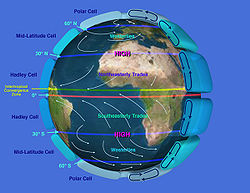
Prevailing winds
Prevailing winds are winds that blow predominantly from a single general direction over a particular point on Earth's surface. The dominant winds are the trends in direction of wind with the highest speed over a particular point on the Earth's surface. A region's prevailing and dominant winds...
of the atmospheric circulation
Atmospheric circulation
Atmospheric circulation is the large-scale movement of air, and the means by which thermal energy is distributed on the surface of the Earth....
arise due to the difference in pressure at various latitudes of Earth
Earth
Earth is the third planet from the Sun, and the densest and fifth-largest of the eight planets in the Solar System. It is also the largest of the Solar System's four terrestrial planets...
and act as means for distribution of thermal energy
Thermal energy
Thermal energy is the part of the total internal energy of a thermodynamic system or sample of matter that results in the system's temperature....
on the planet. This pressure difference is due to the differences in Solar insolation received at different latitudes of Earth
Earth
Earth is the third planet from the Sun, and the densest and fifth-largest of the eight planets in the Solar System. It is also the largest of the Solar System's four terrestrial planets...
and the resulting uneven heating of the planet
Planet
A planet is a celestial body orbiting a star or stellar remnant that is massive enough to be rounded by its own gravity, is not massive enough to cause thermonuclear fusion, and has cleared its neighbouring region of planetesimals.The term planet is ancient, with ties to history, science,...
. Alternating belts of high-pressure and low-pressure develop along the equator
Equator
An equator is the intersection of a sphere's surface with the plane perpendicular to the sphere's axis of rotation and containing the sphere's center of mass....
, the two tropics
Tropics
The tropics is a region of the Earth surrounding the Equator. It is limited in latitude by the Tropic of Cancer in the northern hemisphere at approximately N and the Tropic of Capricorn in the southern hemisphere at S; these latitudes correspond to the axial tilt of the Earth...
, the Arctic
Arctic
The Arctic is a region located at the northern-most part of the Earth. The Arctic consists of the Arctic Ocean and parts of Canada, Russia, Greenland, the United States, Norway, Sweden, Finland, and Iceland. The Arctic region consists of a vast, ice-covered ocean, surrounded by treeless permafrost...
and Antarctic
Antarctic
The Antarctic is the region around the Earth's South Pole, opposite the Arctic region around the North Pole. The Antarctic comprises the continent of Antarctica and the ice shelves, waters and island territories in the Southern Ocean situated south of the Antarctic Convergence...
circles and the twopolar region
Polar region
Earth's polar regions are the areas of the globe surrounding the poles also known as frigid zones. The North Pole and South Pole being the centers, these regions are dominated by the polar ice caps, resting respectively on the Arctic Ocean and the continent of Antarctica...
s giving rise to the Trade wind
Trade wind
The trade winds are the prevailing pattern of easterly surface winds found in the tropics, within the lower portion of the Earth's atmosphere, in the lower section of the troposphere near the Earth's equator...
s, Westerlies
Westerlies
The Westerlies, anti-trades, or Prevailing Westerlies, are the prevailing winds in the middle latitudes between 30 and 60 degrees latitude, blowing from the high pressure area in the horse latitudes towards the poles. These prevailing winds blow from the west to the east, and steer extratropical...
and the Polar easterlies
Polar easterlies
The polar easterlies are the dry, cold prevailing winds that blow from the high-pressure areas of the polar highs at the north and south poles towards low-pressure areas within the Westerlies at high latitudes...
. However, the geophysical factors like revolution of earth
Earth's orbit
In astronomy, the Earth's orbit is the motion of the Earth around the Sun, at an average distance of about 150 million kilometers, every 365.256363 mean solar days .A solar day is on average 24 hours; it takes 365.256363 of these to orbit the sun once in the sense of returning...
, its rotation and axial tilt
Axial tilt
In astronomy, axial tilt is the angle between an object's rotational axis, and a line perpendicular to its orbital plane...
of the Earth result in gradual shifting of these belts northwards and southwards following the Sun
Sun
The Sun is the star at the center of the Solar System. It is almost perfectly spherical and consists of hot plasma interwoven with magnetic fields...
's seasonal shifts.
Process of Monsoon creation
The dynamic theory of Monsoon explains monsoon on the basis of the annual shifts in the position of global belts of pressure and winds. According to it, Monsoon is the result of the shift of the Inter Tropical Convergence Zone (ITCZ) under the influence of the vertical sunSolar equator
The solar equator is the latitude immediately "under" the sun; where the sun is vertically above at midday. Because of the inclination of the Earth's orbit the solar equator varies during the year, from the Tropic of Capricorn in December to the Tropic of Cancer in June....
. Though the mean position of the ITCZ is taken as the equator it keeps shifting northwards and southwards with the migration of the vertical sun towards the tropics (Tropic of Cancer and Tropic of Capricorn
Tropic of Capricorn
The Tropic of Capricorn, or Southern tropic, marks the most southerly latitude on the Earth at which the Sun can be directly overhead. This event occurs at the December solstice, when the southern hemisphere is tilted towards the Sun to its maximum extent.Tropic of Capricorn is one of the five...
) during the summer of the respective hemispheres (Northern
Northern Hemisphere
The Northern Hemisphere is the half of a planet that is north of its equator—the word hemisphere literally means “half sphere”. It is also that half of the celestial sphere north of the celestial equator...
and Southern Hemisphere
Southern Hemisphere
The Southern Hemisphere is the part of Earth that lies south of the equator. The word hemisphere literally means 'half ball' or "half sphere"...
). As such, the theory states that during the northern Summer
Summer
Summer is the warmest of the four temperate seasons, between spring and autumn. At the summer solstice, the days are longest and the nights are shortest, with day-length decreasing as the season progresses after the solstice...
(months of May and June), the ITCZ moves northwards, along with the vertical sun, towards the Tropic of Cancer. The ITCZ being the zone of lowest pressure in the tropical region, is the target destination for the Trade wind
Trade wind
The trade winds are the prevailing pattern of easterly surface winds found in the tropics, within the lower portion of the Earth's atmosphere, in the lower section of the troposphere near the Earth's equator...
s of both the hemispheres. Consequentially, with ITCZ at the Tropic of cancer, the South East Trade winds of the Southern Hemisphere have to cross the equator to reach the ITCZ.When the South East Trade winds cross the equator, in the northern hemisphere they are also perceived as equatorial westerlies since they seem to blowing from the equator towards the Tropic Of Cancer. Similarly, due to the ITCZ being at Tropic of Cancer, the North-East Trades are confined to the north of the Tropic of Cancer However, due to Coriolis effect
Coriolis effect
In physics, the Coriolis effect is a deflection of moving objects when they are viewed in a rotating reference frame. In a reference frame with clockwise rotation, the deflection is to the left of the motion of the object; in one with counter-clockwise rotation, the deflection is to the right...
, these South East are deflected eastwards in the Northern Hemisphere
Northern Hemisphere
The Northern Hemisphere is the half of a planet that is north of its equator—the word hemisphere literally means “half sphere”. It is also that half of the celestial sphere north of the celestial equator...
transforming into South West trades.Change of direction or origin of winds changes their nomenclature as noted above These pick up the moisture while traveling from sea to land and cause orographic rain once they hit the highlands of the Indian Peninsula. This results in the South-West Monsoon.
The dynamic theory provides the explanation of the system of Monsoon
Monsoon
Monsoon is traditionally defined as a seasonal reversing wind accompanied by corresponding changes in precipitation, but is now used to describe seasonal changes in atmospheric circulation and precipitation associated with the asymmetric heating of land and sea...
as a circum-global weather phenomenon rather than just a local one. And when coupled with the Traditional Theory (based on heating of Sea and Land) it enhances the explanation of the differential intensity of precipitation impact of Monsoon along the coastal regions with orographic barriers.
Jet Stream Theory
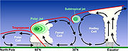
The jet streams are a system of upper-air westerlies. It gives rise to slowly moving upper-air waves, with 250 knots winds in some air streams. First observed by World War II
World War II
World War II, or the Second World War , was a global conflict lasting from 1939 to 1945, involving most of the world's nations—including all of the great powers—eventually forming two opposing military alliances: the Allies and the Axis...
pilots, they develop just below the tropopause over areas of steep pressure gradient on the surface. The main types are the polar jets, the subtropical westerly jets and the less common tropical easterly jets. They follow the principle of geostrophic wind
Geostrophic wind
The geostrophic wind is the theoretical wind that would result from an exact balance between the Coriolis effect and the pressure gradient force. This condition is called geostrophic balance. The geostrophic wind is directed parallel to isobars . This balance seldom holds exactly in nature...
s.Geostrophic winds blow parallel to the isobars and keep low-pressure zone to their left
Process of Monsoon creation
Over India, a subtropical westerly jet develops in the winter season which is replaced by the tropical easterly jet in the summer season. The high temperature over the Tibetan PlateauTibetan Plateau
The Tibetan Plateau , also known as the Qinghai–Tibetan Plateau is a vast, elevated plateau in Central Asia covering most of the Tibet Autonomous Region and Qinghai, in addition to smaller portions of western Sichuan, southwestern Gansu, and northern Yunnan in Western China and Ladakh in...
, as well as over Central Asia in general, during the summer is believed to be the critical factor leading to the formation of the tropical easterly jet over India in summer.
The mechanism affecting monsoon is that the westerly jet causes high pressure over northern parts of the subcontinent during the winter. This results in the north to south flow of the winds in the form of the NE Monsoon. With the northwards shift of the vertical sun, this jet shifts northwards too. The intense heat over the Tibetan Plateau, coupled with associated terrain
Terrain
Terrain, or land relief, is the vertical and horizontal dimension of land surface. When relief is described underwater, the term bathymetry is used...
features of high altitude of the plateau, etc. generate the tropical easterly jet over central India. This jet creates a low pressure zone over the northern Indian plains influencing the wind flow towards these plains, assisting the establishment of the SW Monsoon.
Theory for "Bursting" of Monsoon
The unique feature of bursting of the Monsoon is primarily explained by the Jet Stream theory and the Dynamic Theory.Dynamic Theory
According to this theory, during the summer months of Northern Hemisphere, the ITCZ shifts northwards pulling the SW Monsoon winds onto the land from the sea. However the huge landmass of the Himalayas continue to restrict the low pressure zone onto the Himalayas itself. It is only when the Tibetan Plateau heats up a lot more than the Himalayas does the ITCZ abruptly and swiftly shift northwards leading to burst of Monsoon showers over the Indian subcontinent.The reverse shift takes place for the NE Monsoon winds leading to a second minor burst during the Northern Hemisphere winter Months of NE Monsoon rainfall over Eastern Indian peninsula.
Jet Stream Theory
According to the theory the onset of SW Monsoon over Indian subcontinent is driven by the shift of the subtropical westerly jet northwards from over the plains of India towards the Tibetan Plateau. This shift is due to the intense heating of the Plateau during the summer months. This shift of the westerly jet to the north of the Himalayas is not a slow and gradual process, as expected for most changes in weather pattern. The primary cause of these is believed to be the height of the Himalayas. As the Tibetan Plateau heats up the low pressure created over it pulls the westerly jet northwards. Due to lofty Himalayas, the westerly jet is inhibited from moving northwards. However, with continuous dropping pressure, sufficient force is creating for the movement of the westerly jet across the Himalayas after a significant period. As such the shift of the jet is sudden and abrupt causing the bursting of SW Monsoon rains onto the Indian plains. The reverse shift happens for the NE Monsoon.The Jet Stream effect
The above mentioned Jet Stream theory also explains the variability in timing and strength of the Monsoon.Timing: A timely northward shift of the subtropical westerly jet in the beginning of the summer season is critical to the onset of the SW Monsoon over India. If the northward shift of this jet is delayed, so is the SW Monsoon. An early shift heralds in an early Monsoon.
Strength: Additionally, the strength of the SW Monsoon is determined by the strength of the easterly tropical jet over central India. A strong easterly tropical jet results in a strong SW Monsoon over central India and vice-versa.
El Niño-Southern Oscillation (ENSO) effect
Peru
Peru , officially the Republic of Peru , is a country in western South America. It is bordered on the north by Ecuador and Colombia, on the east by Brazil, on the southeast by Bolivia, on the south by Chile, and on the west by the Pacific Ocean....
that replaces the usual 'cold' Peru or Humboldt
Humboldt
-People:* Alexander von Humboldt, German natural scientist, brother of Wilhelm von Humboldt* Wilhelm von Humboldt , German linguist, philosopher, and diplomat, brother of Alexander von Humboldt- Counties :* Humboldt County, California* Humboldt County, Iowa...
Current. This warm surface water reaching towards the coast of Peru with El Niño is pushed westwards by the trade winds thereby raising the temperature of the southern Pacific Ocean. A reverse condition is known as La Niña.
Southern Oscillation, a phenomenon first observed by Sir Gilbert Thomas Walker
Gilbert Walker
Sir Gilbert Thomas Walker, CSI, FRS, was a British physicist and statistician of the 20th century. He is best known for his groundbreaking description of the Southern Oscillation, a major phenomenon of global climate, and for greatly advancing the study of climate in general.He was born in...
Director-General of Observatories in India, refers to the seesaw relationship of atmospheric pressures between Tahiti
Tahiti
Tahiti is the largest island in the Windward group of French Polynesia, located in the archipelago of the Society Islands in the southern Pacific Ocean. It is the economic, cultural and political centre of French Polynesia. The island was formed from volcanic activity and is high and mountainous...
and Darwin
Darwin, Northern Territory
Darwin is the capital city of the Northern Territory, Australia. Situated on the Timor Sea, Darwin has a population of 127,500, making it by far the largest and most populated city in the sparsely populated Northern Territory, but the least populous of all Australia's capital cities...
, Australia
Australia
Australia , officially the Commonwealth of Australia, is a country in the Southern Hemisphere comprising the mainland of the Australian continent, the island of Tasmania, and numerous smaller islands in the Indian and Pacific Oceans. It is the world's sixth-largest country by total area...
. He noticed that when it was high pressure in Tahiti, it was low pressure in Darwin and vice versa. A Southern Oscillation Index (SOI),based on the pressure difference between Tahiti and Darwin, has been formulated by the Bureau of Meteorology (Australia) to measure the strength of the Oscillation. Walker noticed that the quantity of rainfall in the Indian subcontinent was often negligible in the years of high pressure at Darwin (and low pressure at Tahiti). Conversely, low pressure at Darwin bode well for the precipitation quantity in India. Thus he established the relationship of Southern Oscillation with quantities of Monsoon rains in India.
Ultimately, it was realized that the Southern Oscillation is just the corresponding atmospheric component of the El Niño/La Niña effect (which happens in the Ocean). Therefore in the context of the Monsoon, the two cumulatively came to be known as the ENSO.
The ENSO is known to have a pronounced effect on the strength of SW Monsoon over India with the Monsoon being weak (causing droughts in India) during the El Niño years whereas La Niña years had particularly good Monsoon strength over India.
Indian Ocean Dipole effect
Although ENSO was statistically effective in explaining several past droughts in India, in the recent decades the ENSO-Monsoon relationship seemed to weaken in the Indian subcontinent. For e.g. the 1997, strong ENSO failed to cause drought in India. However, it was later discovered that just like ENSO was an event in he Pacific OceanPacific Ocean
The Pacific Ocean is the largest of the Earth's oceanic divisions. It extends from the Arctic in the north to the Southern Ocean in the south, bounded by Asia and Australia in the west, and the Americas in the east.At 165.2 million square kilometres in area, this largest division of the World...
, a similar seesaw ocean-atmosphere system in the Indian Ocean
Indian Ocean
The Indian Ocean is the third largest of the world's oceanic divisions, covering approximately 20% of the water on the Earth's surface. It is bounded on the north by the Indian Subcontinent and Arabian Peninsula ; on the west by eastern Africa; on the east by Indochina, the Sunda Islands, and...
was also at play. It was discovered in 1999 and named the Indian Ocean Dipole
Indian Ocean Dipole
The Indian Ocean Dipole is an irregular oscillation of sea-surface temperatures in which the western Indian Ocean becomes alternately warmer and then colder than the eastern part of the ocean.-The phenomenon:...
(IOD). An index to calculate it was also formulated. IOD develops in the equatorial region of Indian Ocean from April to May peaking in October. With a positive IOD winds over the Indian Ocean blow from east to west. This results in the Arabian Sea (western Indian Ocean near African Coast) being much warmer and eastern Indian Ocean around Indonesia becoming colder and dry. In the negative dipole year, reverse happens making Indonesia much warmer and rainier.
It was demonstrated that a positive IOD index often negated the effect of ENSO, resulting in increased Monsoon rains in several ENSO years like the 1983, 1994 and 1997. Further, it was shown tha the two poles of the IOD - the eastern pole (around Indonesia) and the western pole (off the African coast) were independently and cumulatively affecting the quantity of rains for the Monsoon in the Indian subcontinent.
Equatorial Indian Ocean Oscillation
Similar to ENSO, the atmospheric component of the IOD was later discovered and named as Equatorial Indian Ocean Oscillation (EQUINOO). When EQUINOO effects were factored into the statistics certain failed forecasts, like the acute drought of year 2002, could be further accounted for. The relationship between extremes of the Indian summer monsoon rainfall, along with ENSO and EQUINOO have been studied and models for enhanced predictability of the quantity of monsoon rains have been statistically derived.Monsoon Rain prediction models
Since the Great Famine of 1876–78Great Famine of 1876–78
The Great Famine of 1876–1878 was a famine in India that began in 1876 and affected south and southwestern India for a period of two years...
in India, various attempts have been made to predict the rainfall during the Monsoons in India. At least five models for prediction of Monsoon rains exist in India.
Seasonal Prediction of Indian Monsoon(SPIM)
Centre for Development of Advanced ComputingCentre for Development of Advanced Computing
Centre for Development of Advanced Computing is a research and development organization under the Department of Information Technology, India.-History:...
(CDAC) at Bengaluru is facilitating the Seasonal Prediction of Indian Monsoon(SPIM) experiment on the PARAM
PARAM
PARAM is a series of supercomputers designed and assembled by the Centre for Development of Advanced Computing in Pune, India. The latest machine in the series is the PARAM Yuva.Param means supreme in Sanskrit.-History:...
Padma supercomputing system.
This project did simulated runs on historical data from 1985 to 2004 to try and establish the relationship between of five atmospheric general circulation models with the Monsoon rainfall distribution.
Indian Meteorological Department Model
IMD has tried to forecast the Monsoon for India since 1884, some unsuccessfully but till 2011 is the only official agency entrusted with making public forecasts about the quantity, distribution and timings of the Monsoon in India. IMD's position as the sole authority on the matter was further reiterated in 2005 by the Department of Science and Technology (DST)Department of Science and Technology (India)
The Department of Science and Technology is a department within the Ministry of Science and Technology in India. It was established in May 1971, with the objective of promoting new areas of Science and Technology and to play the role of a nodal department for organising, coordinating and promoting...
, New Delhi
New Delhi
New Delhi is the capital city of India. It serves as the centre of the Government of India and the Government of the National Capital Territory of Delhi. New Delhi is situated within the metropolis of Delhi. It is one of the nine districts of Delhi Union Territory. The total area of the city is...
. In 2003, IMD underwent a substantial change in its forecast methodology, model as well as its administration. A sixteen parameter monsoon forecasting model used by the Indian met office since 1988 was revamped in 2003 with a new one. However, following the 2009 drought in India (worst since 1972), IMD decided in 2010 that it needed to develop an indigenous model to further enhance its prediction capabilities.
Significance
Indian Monsoon is the primary delivery mechanism for fresh waterFresh Water
Fresh Water is the debut album by Australian rock and blues singer Alison McCallum, released in 1972. Rare for an Australian artist at the time, it came in a gatefold sleeve...
in the Indian subcontinent. As such it impacts the environment
Natural environment
The natural environment encompasses all living and non-living things occurring naturally on Earth or some region thereof. It is an environment that encompasses the interaction of all living species....
(and associated flora, fauna and ecosystem
Ecosystem
An ecosystem is a biological environment consisting of all the organisms living in a particular area, as well as all the nonliving , physical components of the environment with which the organisms interact, such as air, soil, water and sunlight....
s), agriculture, society, hydro-power production and geography of the subcontinent (like availability of fresh water in water bodies, underground water table) with all these factors cumulatively contributing towards the health of the economy of affected countries.
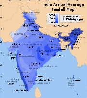
Geographical (Wettest Spots on Earth)
MawsynramMawsynram
Mawsynram is a village in the East Khasi Hills district of Meghalaya state in north-eastern India, 56 kilometers from Shillong. It is reportedly the wettest place on Earth, with an annual rainfall of...
and Cherrapunji
Cherrapunji
Cherrapunji , is a subdivisional town in the East Khasi Hills district in the Indian state of Meghalaya. It is credited as being the second wettest place on Earth...
, both in the Indian state of Meghalaya
Meghalaya
Meghalaya is a state in north-eastern India. The word "Meghalaya" literally means the Abode of Clouds in Sanskrit and other Indic languages. Meghalaya is a hilly strip in the eastern part of the country about 300 km long and 100 km wide, with a total area of about 8,700 sq mi . The...
alternate to be the wettest places on Earth given the quantity of their rainfall. There are other cities with similar claims but with 10,000mm of rain for each of these locations, Monsoon of Indian subcontinent is significant contributor towards the water supply of its area of influence.
Agricultural
India, historically an agrarian economy primarily, has recently seen the services sector overtaking the farm sector in terms of GDP contribution. However, even today agricultureAgriculture
Agriculture is the cultivation of animals, plants, fungi and other life forms for food, fiber, and other products used to sustain life. Agriculture was the key implement in the rise of sedentary human civilization, whereby farming of domesticated species created food surpluses that nurtured the...
sector contributes 17-20% of GDP and is the largest employer in the country with about 60% of people dependent on it for employment and livelihood. The land use pattern of India indicates that 49% of land is under agriculture in India, it is 55% if associated wetlands agriculture, dryland farming
Dryland farming
Dryland farming is an agricultural technique for non-irrigated cultivation of drylands.-Locations:Dryland farming is used in the Great Plains, the Palouse plateau of Eastern Washington, and other arid regions of North America, the Middle East and in other grain growing regions such as the steppes...
areas, etc. are included. Since over half of these farmlands are rain-fed, Monsoon is critical to the food sufficiency and quality of life for the country.
Despite progress in alternative forms of irrigation, agricultural dependency on monsoon is far from insignificant, even today. Therefore, the agricultural calendar of India is governed by Monsoon. Any fluctuations in the time distribution, spatial distribution or quantity of the monsoon rains may lead to conditions of floods or droughts causing the agricultural sector to adversely suffer. This has a cascading effect on the secondary economic sectors, the overall economy, food inflation and therefore the overall quality and cost of living for the general population in India.
Economic
The economic significance of monsoon can be aptly summed up by Pranab MukherjeePranab Mukherjee
Pranab Kumar Mukherjee is the current Finance Minister of India and leader of the current Lok Sabha.Mukherjee is a senior member of the Cabinet Committees on Economic Affairs, Infrastructure, Parliamentary Affairs, Political Affairs, Prices, Security, Unique Identification Authority of India,...
's statement that monsoon is the real finance minister of India.
A good monsoon resulting in improved agricultural brings down prices of essential food commodities and reduces their imports overall reducing the food inflation. Further improved rains result in increased hydroelectric production.
All these factors initiate positive ripple effects throughout the economy of India.
Social
D. Subbarao (Governor of Reserve Bank of India), during a quarterly review of the monetary policyMonetary policy
Monetary policy is the process by which the monetary authority of a country controls the supply of money, often targeting a rate of interest for the purpose of promoting economic growth and stability. The official goals usually include relatively stable prices and low unemployment...
, once highlighted that lives of Indians depends on the performance of Monsoon. His own personal career prospects, emotional well being and the performance of his monetary policy were all a hostage to monsoon like it was for most Indians. Additionally, farmers, rendered jobless due to failed Monsoon rains tend to migrate city-wards. This crowds the city slums and further aggravates the job, infrastructure and sustainability of city life. Such is the magnitude of effect that monsoon casts on the lives of Indians.
Environmental
The Monsoon is the primary bearer of fresh water to the aquaticAquatic
Aquatic means relating to water; living in or near water or taking place in waterAquatic may also refer to:* Aquatic animal, either vertebrate or invertebrate, which lives in water for most or all of its life...
water bodies. The peninsular/Deccan rivers of India are mostly rain-fed and non-perennial in nature depending primarily on the Monsoon for water supply.
Similarly most of the coastal rivers of Western India are rain-fed and Monsoon dependant. As such, obviously the flora, fauna and the entire ecosystem
Ecosystem
An ecosystem is a biological environment consisting of all the organisms living in a particular area, as well as all the nonliving , physical components of the environment with which the organisms interact, such as air, soil, water and sunlight....
of these areas are heavily dependant on the Monsoon.
See also
- MonsoonMonsoonMonsoon is traditionally defined as a seasonal reversing wind accompanied by corresponding changes in precipitation, but is now used to describe seasonal changes in atmospheric circulation and precipitation associated with the asymmetric heating of land and sea...
- North American MonsoonNorth American MonsoonThe North American monsoon, variously known as the Southwest United States monsoon, the Mexican monsoon, or the Arizona monsoon, is experienced as a pronounced increase in rainfall from an extremely dry June to a rainy July over large areas of the southwestern United States and northwestern Mexico...
- Monsoon troughMonsoon troughThe monsoon trough is that portion of the Intertropical Convergence Zone which extends into or through a monsoon circulation, as depicted by a line on a weather map showing the locations of minimum sea level pressure, and as such, is a convergence zone between the wind patterns of the southern and...
- Climate of IndiaClimate of IndiaAnalyzed according to the Köppen system, the climate of India resolves into six major climatic subtypes; their influences give rise to desert in the west, alpine tundra and glaciers in the north, humid tropical regions supporting rain forests in the southwest, and Indian Ocean island territories...
(section Monsoon) - Tropical monsoon climateTropical monsoon climateTropical monsoon climate, occasionally also known as a tropical wet climate or tropical monsoon and trade-wind littoral climate in climate classification, is a relatively rare type of climate that corresponds to the Köppen climate classification category "Am."Tropical monsoon climates have monthly...
(section Factors) - Tibetan PlateauTibetan PlateauThe Tibetan Plateau , also known as the Qinghai–Tibetan Plateau is a vast, elevated plateau in Central Asia covering most of the Tibet Autonomous Region and Qinghai, in addition to smaller portions of western Sichuan, southwestern Gansu, and northern Yunnan in Western China and Ladakh in...
(section Role in monsoons) - HimalayasHimalayasThe Himalaya Range or Himalaya Mountains Sanskrit: Devanagari: हिमालय, literally "abode of snow"), usually called the Himalayas or Himalaya for short, is a mountain range in Asia, separating the Indian subcontinent from the Tibetan Plateau...
(section Impact on climate) - Prevailing windsPrevailing windsPrevailing winds are winds that blow predominantly from a single general direction over a particular point on Earth's surface. The dominant winds are the trends in direction of wind with the highest speed over a particular point on the Earth's surface. A region's prevailing and dominant winds...
- Jet StreamJet streamJet streams are fast flowing, narrow air currents found in the atmospheres of some planets, including Earth. The main jet streams are located near the tropopause, the transition between the troposphere and the stratosphere . The major jet streams on Earth are westerly winds...
- RainRainRain is liquid precipitation, as opposed to non-liquid kinds of precipitation such as snow, hail and sleet. Rain requires the presence of a thick layer of the atmosphere to have temperatures above the melting point of water near and above the Earth's surface...
- Walker circulationWalker circulationThe Walker circulation, also known as the Walker cell, is a conceptual model of the air flow in the tropics in the lower atmosphere . According to this model parcels of air follow a closed circulation in the zonal and vertical directions...
- Indian peninsula
- Indian Meteorological Department
- Drought in IndiaDrought in IndiaDrought in India has resulted in tens of millions of deaths over the course of the 18th, 19th, and 20th centuries. Indian agriculture is heavily dependent on the climate of India: a favorable southwest summer monsoon is critical in securing water for irrigating Indian crops...
- Andhra PradeshAndhra PradeshAndhra Pradesh , is one of the 28 states of India, situated on the southeastern coast of India. It is India's fourth largest state by area and fifth largest by population. Its capital and largest city by population is Hyderabad.The total GDP of Andhra Pradesh is $100 billion and is ranked third...
(section of Geography and climate) - MonsoonMonsoonMonsoon is traditionally defined as a seasonal reversing wind accompanied by corresponding changes in precipitation, but is now used to describe seasonal changes in atmospheric circulation and precipitation associated with the asymmetric heating of land and sea...
(section of South Asian Monsoon)