

Guwahati
Encyclopedia
Guwahati, Pragjyotishpura in ancient Assam (Assamese
: গুৱাহাটী, Sanskrit: प्राग्ज्योतिषपुर spelled as Guwāhāti - with diacritics
) formerly known as Gauhati is a metropolis
,the largest city of Assam
in India
and ancient urban area in North East India, with a population of 963,429(2011 census). It is also the largest metropolitan area
in north-eastern India. It is said to be the "Gateway" of the North East Region and is also regarded as the third largest city in eastern India after Kolkata
and Patna
respectively. During the past few decades it has experienced unprecedented spatial expansion and also steep rise in population. The city is one of the most rapidly growing cities in India, in fact according to a survey done by a UK media, Guwahati is among the first 100 fastest growing city of the world and is 5th fastest growing among Indian cities. Dispur, the capital of the Indian state of Assam
is located within the city and is the seat of the Government of Assam
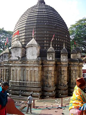
. Guwahati formerly Pragjyotishpura (Sanskrit word meaning city of eastern light), was the capital of Ancient state of Kamarupa. The city has many ancient hindu temples located within the city. Kamakhya Temple
, Umananda Temple, Navagraha Temple, Sukreswar Temple
, Basistha Temple
, Lankeshwar Temple
, Doul Govinda Temple
, Dirgheshwari temple
, Ugro Tara Temple
, Rudreswar Temple
, etc., are to be named a few. Thus, the city is also known as the "City of Temples."
The city is situated between the southern bank of the Brahmaputra river and the foothills of the Shillong plateau
, with LGB International Airport
to the west, and the town of Narengi to the east. The city is gradually being expanded as North Guwahati
to the northern bank of the Brahmaputra. The Guwahati Municipal Corporation
, the city's local government, administers an area of 216 km², while the Guwahati Metropolitan Development Authority
, the planning and development administers an area of 340 km².
Guwahati is a major commercial and educational center of North-East India
and is home to world class institutions such as the Indian Institute of Technology Guwahati
and other premier institutions like Gauhati University
and Cotton College
. The city is also a major center for cultural activities and sports in the North Eastern region and for the administrative and political activities of Assam. The city is also an important hub for transportation in the North East Region.
Guwahati and its environs are also rich in wildlife with several rare mammals such as Asian elephants, Gaur, Tiger and primates. The birdlife in and around the city is also rich and diverse.
words: 'guwa' (areca nut) and 'haat' (market place). The name used to be spelled as Gowhatty (pre-colonial and colonial), standardized to Gauhati (colonial-British), which was then changed to the present form in the late 1980s to conform to the local pronunciation.
.
Epigraphic sources place the capitals of many ancient kingdoms in Guwahati. It was the capital of the 'mythological' kings Narakasura
and Bhagadatta
according to the Mahabharata
. The ancient sakti temple of Goddess Kamakhya
located in Nilachal hill (also important seat of Tantric
and Vajrayana
Buddhism
), the ancient and unique astrological temple Navagraha located in Chitrachal Hill, and archaeological remains in Basista and other locations support the mythological assertions of the city's ancient past.
 The Ambari excavations trace the city to the 6th century AD. The city was known as Pragjyotishpura (i.e. light of the east ) and Durjoya in different time periods, and was the capital under the Varman
and the Pala
dynasties of the Kamarupa kingdom. Descriptions by Xuanzang
(Hiuen Tsang) reveal that during the greatest Varman king Bhaskaravarma (7th century AD), the city stretched 19 km and was probably the principal base for his strong naval force (30,000 war-boats, with officers who were knowledgeable of the sea-routes from the Indian Ocean to China - Xuanzang
). The city remained as the capital of Assam till the 10-11th century AD under the rulers of the Pala dynasty. Excavations in Ambari, and the brick walls and houses excavated during construction of the present Cotton College
's auditorium suggest that it was a city of great size with economic and strategic importance until the 9-11th century AD.
During medieval times between the 12-15th century AD, after the destruction of the Kamata kingdom
, the city lost its earlier glory and became mainly a strategic outpost of the Koch Hajo
and Ahom Kingdom
s of western and eastern Assam. When the western part of the Koch Kingdom (Koch Bihar
) fell to the Mughals, the eastern half (Koch Hajo) eventually became a protectorate of Ahom. Although the actual border between both powers (Ahoms and Mughals) fluctuated between the Kartoya river (now in North Bengal) to the Manas and Barnadi rivers, Guwahati remained an important outpost.
 The city was the seat of the Borphukan
, the civil military authority of the lower Assam region appointed by the Ahom
kings. The Borphukan's residence was in the present Fansi Bazaar area, and his council-hall, called Dopdar, was situated about 300 yards (274.3 m) to the west of the Bharalu stream. The Majindar Baruah, the personal secretary of the Borphukan, had his residence in the present-day Deputy Commissioner's residence .
The Mughals tried to invade Assam 17 times and each time they were defeated by the Ahoms led by the great Ahom general Bir Lachit Borphukan
. The Battle of Saraighat fought close to Guwahati in 1671 is the most well known of all those battles, in which the Mughals were over-run due to the strong leadership of Lachit Borphukan and hard work of the Assamese Army. The great embankment called "Mumai-Kota Gor" (named after the incident involving Lachit killing his own uncle for being lazy in building it) that runs along the outskirts of Guwahati stands as a proof of the hardwork and war-readiness on the part of the Ahoms.
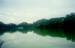
There are a number of historic features in Guwahati. The Dighali Pukhuri is a rectangular lake that was connected to the Brahmaputra, and was an ancient boat yard probably used by the Ahoms in medieval times. Moreover, there are many tanks, temples, ramparts, etc. in the city. The most important archaeological site is the Ambari excavation site close to Dighali Pukhuri.
A new cantilever bridge across river Brahmaputra has been planned to link North Guwahati.
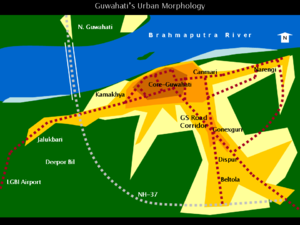 Guwahati's 'urban form' is somewhat like a starfish. With a core in the central areas, the city has tentacles extending in the form of growth corridors towards south, east and west. In the past few decades, southern Guwahati areas such as Ganeshguri, Beltola
, Panjabari, Jatia, Kahilipara etc. began forming a southern sub-center surrounding the capital complex at Dispur, principally depending on the GS Road corridor.
the area which is near about 5 km from dispur i.e. panjabari area is really very beautiful.it is place of full natural beauty and climatic condition are somehow similar to Meghalaya.Shankardev Kalakshetra is one of popular tourist spot in this area.
The core area consists of the old city with Pan Bazaar
, Paltan Bazaar
, Fansi Bazaar and Uzan Bazaar, each one facilitating unique urban activities. While Paltan Bazaar is the hub for transportation and hotels, Pan Bazaar is centered around educational, administrative, cultural activities, offices and restaurants. Fansi Bazaar is the hub for retail and wholesale commercial activities, and Ujan Bazaar mainly contains administrative, retail and residential areas. With these bustling areas, the city core is a busy and lively part of the Guwahati. Ulubari, Lachit Nagar, Chandmari and Zoo Road (R.G. Baruah Road), which have a mix of retail-commercial and residential areas, can be considered an additional part of the core.
Among the city corridors, the most important is the corridor formed along the Guwahati-Shillong (GS) Road towards the south (almost 15 km from the city-center). The GS Road corridor is an important commercial area with retail, wholesale and offices developed along the main road, and it is also a densely-built residential area in the inner parts. The capital complex of Assam at Dispur is situated in this corridor. This corridor has facilitated the growth of a southern city sub-center at Ganeshguri, along with other residential areas to the south developed during the past few decades.
The corridor extending towards the west (around 30 km from the city-center) contains a rail-road linking not only Guwahati but also other parts of the North Eastern Region east of Guwahati to western Assam and the rest of India. The corridor links residential and historically important areas such as Nilachal Hill (Kamakhya), Pandu
, and Maligaon (headquarters of Northeast Frontier Railways) before it separates into two - one towards North Guwahati
and the other continuing west towards LGB International Airport
via the University of Gauhati
(Jalukbari). There are also many river ports/jetties along this corridor.
The third major corridor extends towards the east (around 15 km from the city-center) linking Noonmati
(Guwahati Oil Refinery - IOC Ltd.) and Narengi, and has facilitated residential growth along it.
Highway NH 37, which encircles the city's southern parts and links the southern corridor in Nomile to the western corridor in Jalukbari is currently supporting rapid development. Similarly, the VIP Road linking Zoo Road with the eastern corridor and recently completed Hengerabari-Narengi Road are also supporting massive residential development to the east.
In brief, the major components of Guwahati's urban structure are:
But the city is having notable changes in its morphology with rapid expansion. The Khanapara road is being converted into 4 lanes and it will be extended up to a place called Changsari in near future. Various projects are undertaken on the outskirts like the water park in Rani, which has brought those far flung areas under city reach by continuous visit by tourists. Also, two five star hotels are on the verge of being set up, arising hopes that by a decade or so, the city will be twice its size now.
Assamese language
Assamese is the easternmost Indo-Aryan language. It is used mainly in the state of Assam in North-East India. It is also the official language of Assam. It is also spoken in parts of Arunachal Pradesh and other northeast Indian states. Nagamese, an Assamese-based Creole language is widely used in...
: গুৱাহাটী, Sanskrit: प्राग्ज्योतिषपुर spelled as Guwāhāti - with diacritics
Diacritics
diacritics is a quarterly academic journal established in 1971 at Cornell University and published by the Johns Hopkins University Press. Articles serve to review recent literature in the field of literary criticism, and have covered topics in gender studies, political theory, psychoanalysis, queer...
) formerly known as Gauhati is a metropolis
Metropolis
A metropolis is a very large city or urban area which is a significant economic, political and cultural center for a country or region, and an important hub for regional or international connections and communications...
,the largest city of Assam
Assam
Assam , also, rarely, Assam Valley and formerly the Assam Province , is a northeastern state of India and is one of the most culturally and geographically distinct regions of the country...
in India
India
India , officially the Republic of India , is a country in South Asia. It is the seventh-largest country by geographical area, the second-most populous country with over 1.2 billion people, and the most populous democracy in the world...
and ancient urban area in North East India, with a population of 963,429(2011 census). It is also the largest metropolitan area
Metropolitan area
The term metropolitan area refers to a region consisting of a densely populated urban core and its less-populated surrounding territories, sharing industry, infrastructure, and housing. A metropolitan area usually encompasses multiple jurisdictions and municipalities: neighborhoods, townships,...
in north-eastern India. It is said to be the "Gateway" of the North East Region and is also regarded as the third largest city in eastern India after Kolkata
Kolkata
Kolkata , formerly known as Calcutta, is the capital of the Indian state of West Bengal. Located on the east bank of the Hooghly River, it was the commercial capital of East India...
and Patna
Patna
Paṭnā , is the capital of the Indian state of Bihar and the second largest city in Eastern India . Patna is one of the oldest continuously inhabited places in the world...
respectively. During the past few decades it has experienced unprecedented spatial expansion and also steep rise in population. The city is one of the most rapidly growing cities in India, in fact according to a survey done by a UK media, Guwahati is among the first 100 fastest growing city of the world and is 5th fastest growing among Indian cities. Dispur, the capital of the Indian state of Assam
Assam
Assam , also, rarely, Assam Valley and formerly the Assam Province , is a northeastern state of India and is one of the most culturally and geographically distinct regions of the country...
is located within the city and is the seat of the Government of Assam
Government of Assam
The Government of Assam is the provincial governing authority of the state of Assam in the Republic of India.It consists of the Governor as the head of the state, who is nominated by the Government of India. The head of government is the Chief Minister, who is the leader of the group that commands...
. Guwahati formerly Pragjyotishpura (Sanskrit word meaning city of eastern light), was the capital of Ancient state of Kamarupa. The city has many ancient hindu temples located within the city. Kamakhya Temple
Kamakhya Temple
The Kamakhya Temple is a Shakti Peeth temple situated on the Nilachal Hill in western part of Guwahati city in Assam, India. It is the main temple in a complex of individual temples dedicated to different forms of the mother goddess as the Dasa Mahavidya, including Bhuvaneshvari, Bagalamukhi,...
, Umananda Temple, Navagraha Temple, Sukreswar Temple
Sukreswar Temple
The Sukreswar Temple is an important Shiva temple in the state of Assam in India and was constructed in 1744 by Ahom King Pramatta Singha . King Rajeswar Singha who also promoted cause of the Saiva cult made financial provisions for the Sukreswar Temple in 1759...
, Basistha Temple
Basistha Temple
Basistha temple, located in the south-east corner of Guwahati city is a Shiva mandir constructed by Ahom King Rajeswar Singha along with gift of land 835 Bighas for the ashram. The history of the Basistha Ashram where the temple is located dates back to the Vedic age...
, Lankeshwar Temple
Lankeshwar Temple
Lankeshwar Temple is an ancient Shiva temple on top of a hillock in the western part of the Guwahati city near Gauhati University campus. The Lankeshwar Temple of Assam is an ancient temple dedicated to Lord Shiva. The temple is placed atop a hill amidst a picturesque location. Lankeshwar is one of...
, Doul Govinda Temple
Doul Govinda Temple
Doul Govinda Temple is one of the famous temples of Assam. It is situated on the northern banks, on the foot hills of Chandrabharati hill at Rajaduar, North Guwahati. The temple is mainly devoted to Lord Krishna. Besides, there is an Namghar along with the temple within the same premises...
, Dirgheshwari temple
Dirgheshwari temple
Dirgheshwari Temple is a temple situated in the northern banks of the river Brahmaputra in Guwahati, Assam. The Temple is one of the Shakti Peethas constructed during the reign of medieval ruler Siba Singha or Sutanphaa ....
, Ugro Tara Temple
Ugro Tara Temple
A temple dedicated to Tara located in the western side of Jor Pukhury tanks in the heart of Guwahati city in the Lotaxil locality. The Ugratara Temple in Uzan Bazaar in the eastern part of Guwahati, Assam is an important Sakti shrine. Legend has it that the navel of Sati, the wife of Lord Shiva,...
, Rudreswar Temple
Rudreswar Temple
The Rudreswar Devaloy was built by Ahom King Pramatta Singha in honour of his father Rudra Singha who died in August, 1714. It is located in North Guwahati in Mani Karneswar area on the northern bank of River Brahmaputra...
, etc., are to be named a few. Thus, the city is also known as the "City of Temples."
The city is situated between the southern bank of the Brahmaputra river and the foothills of the Shillong plateau
Shillong
-Connectivity:Although well connected by road, Shillong has no rail connection and a proper air connection. Umroi Airport exists but has only limited flights.-Roadways:Shillong is well connected by roads with all major north eastern states...
, with LGB International Airport
Lokpriya Gopinath Bordoloi International Airport
Lokpriya Gopinath Bordoloi International Airport , also known as Guwāhāti International Airport and formerly as Borjhar Airport, is the airport of Guwahati, Assam, India. The airport is managed by Airports Authority of India and also serves as Indian Air Force base...
to the west, and the town of Narengi to the east. The city is gradually being expanded as North Guwahati
North Guwahati
North Guwahati is northern part of city of Guwahati and a town area committee in Kamrup district in the Indian state of Assam.This town which abounds in historical places and picnic spots. National Highway 31 passes through North Guwahati.-Geography:...
to the northern bank of the Brahmaputra. The Guwahati Municipal Corporation
Guwahati Municipal Corporation
Guwahati Municipal Corporation or GMC in short is the local government in Guwahati. A municipal corporation is the highest form of a urban local body in India. Presently, GMC covers an area of 216 km² under its jurisdiction and it is divided into 60 municipal wards.The GMc was set up by the...
, the city's local government, administers an area of 216 km², while the Guwahati Metropolitan Development Authority
Guwahati Metropolitan Development Authority
Guwahati Metropolitan Development Authority or GMDA is a state parastatal agency of Government of Assam created for the Guwahati metropolitan area. The authority is responsible for planning and development of the metropolitan region and is currently preparing the revised master plan for Guwahati...
, the planning and development administers an area of 340 km².
Guwahati is a major commercial and educational center of North-East India
North-East India
Northeast India refers to the easternmost region of India consisting of the contiguous Seven Sister States, Sikkim, and parts of North Bengal...
and is home to world class institutions such as the Indian Institute of Technology Guwahati
Indian Institute of Technology Guwahati
Indian Institute of Technology Guwahati is an autonomous engineering and technology-oriented institute of higher education established by the Government of India, located in Guwahati, in the state of Assam in India...
and other premier institutions like Gauhati University
Gauhati University
Gauhati University, the first university of North East India, is in the Jalukbari area in the western part Guwahati city, Assam, India. It was established in 1948. It is a four-star rated university by the National Assessment and Accreditation Council. It has 183 affiliated colleges.- Campus :The...
and Cotton College
Cotton College
Cotton College was a Roman Catholic boarding school AT in Cotton near Oakamoor, North Staffordshire, England, also known as Saint Wilfrid's College. It closed in 1987 and the site is now derelict....
. The city is also a major center for cultural activities and sports in the North Eastern region and for the administrative and political activities of Assam. The city is also an important hub for transportation in the North East Region.
Guwahati and its environs are also rich in wildlife with several rare mammals such as Asian elephants, Gaur, Tiger and primates. The birdlife in and around the city is also rich and diverse.
Etymology
The name Guwahati is derived from two AssameseAssamese language
Assamese is the easternmost Indo-Aryan language. It is used mainly in the state of Assam in North-East India. It is also the official language of Assam. It is also spoken in parts of Arunachal Pradesh and other northeast Indian states. Nagamese, an Assamese-based Creole language is widely used in...
words: 'guwa' (areca nut) and 'haat' (market place). The name used to be spelled as Gowhatty (pre-colonial and colonial), standardized to Gauhati (colonial-British), which was then changed to the present form in the late 1980s to conform to the local pronunciation.
History
Guwahati's myths and history go back several thousands of years. Although the date of the city's beginning is unknown, references in the epics, puranas, and other traditional histories, lead many to assume that it is one of the ancient cities of AsiaAsia
Asia is the world's largest and most populous continent, located primarily in the eastern and northern hemispheres. It covers 8.7% of the Earth's total surface area and with approximately 3.879 billion people, it hosts 60% of the world's current human population...
.
Epigraphic sources place the capitals of many ancient kingdoms in Guwahati. It was the capital of the 'mythological' kings Narakasura
Narakasura
In Hindu beliefs, Narakasura or Naraka is the asura son of the earth goddess Bhudevi and Lord Vishnu in his Varaha Avatar . In other sources, he is the son of the asura Hiranyaksha. He is said to have established the kingdom of Pragjyotisha in Assam after overthrowing the last of the Danava king...
and Bhagadatta
Bhagadatta
Bhagadatta, was the son of Narakasura. He was a king of the city Pragjyotisha in the epic Mahabharata. In the Battle of Kurukshetra, Bhagadatta fought on the side of the Kauravas. He was very well known to attack his enemies with his elephant in the warfare. In the Mahabharata war, he was...
according to the Mahabharata
Mahabharata
The Mahabharata is one of the two major Sanskrit epics of ancient India and Nepal, the other being the Ramayana. The epic is part of itihasa....
. The ancient sakti temple of Goddess Kamakhya
Kamakhya Temple
The Kamakhya Temple is a Shakti Peeth temple situated on the Nilachal Hill in western part of Guwahati city in Assam, India. It is the main temple in a complex of individual temples dedicated to different forms of the mother goddess as the Dasa Mahavidya, including Bhuvaneshvari, Bagalamukhi,...
located in Nilachal hill (also important seat of Tantric
Tantra
Tantra , anglicised tantricism or tantrism or tantram, is the name scholars give to an inter-religious spiritual movement that arose in medieval India, expressed in scriptures ....
and Vajrayana
Vajrayana
Vajrayāna Buddhism is also known as Tantric Buddhism, Tantrayāna, Mantrayāna, Secret Mantra, Esoteric Buddhism and the Diamond Vehicle...
Buddhism
Buddhism
Buddhism is a religion and philosophy encompassing a variety of traditions, beliefs and practices, largely based on teachings attributed to Siddhartha Gautama, commonly known as the Buddha . The Buddha lived and taught in the northeastern Indian subcontinent some time between the 6th and 4th...
), the ancient and unique astrological temple Navagraha located in Chitrachal Hill, and archaeological remains in Basista and other locations support the mythological assertions of the city's ancient past.
Varman
Varman is a village in Sirohi District in Rajasthan state in India. It is 45 km from Abu Road and formerly known as Brahmana.It was a prosperous town in the past. The place was famous for Sun Temple known as Brahmana Svamin. The temple is also called Surya Narayana and was built in the seventh...
and the Pala
Pala Empire
The Pāla Empire was one of the major middle kingdoms of India existed from 750–1174 CE. It was ruled by a Buddhist dynasty from Bengal in the eastern region of the Indian subcontinent, all the rulers bearing names ending with the suffix Pala , which means protector. The Palas were often described...
dynasties of the Kamarupa kingdom. Descriptions by Xuanzang
Xuanzang
Xuanzang was a famous Chinese Buddhist monk, scholar, traveler, and translator who described the interaction between China and India in the early Tang period...
(Hiuen Tsang) reveal that during the greatest Varman king Bhaskaravarma (7th century AD), the city stretched 19 km and was probably the principal base for his strong naval force (30,000 war-boats, with officers who were knowledgeable of the sea-routes from the Indian Ocean to China - Xuanzang
Xuanzang
Xuanzang was a famous Chinese Buddhist monk, scholar, traveler, and translator who described the interaction between China and India in the early Tang period...
). The city remained as the capital of Assam till the 10-11th century AD under the rulers of the Pala dynasty. Excavations in Ambari, and the brick walls and houses excavated during construction of the present Cotton College
Cotton College, Guwahati
Cotton College is a premier institution for higher education located in the heart of Guwahati, Assam, a northeastern state of India.240px|right|thumb| Cotton College, the premier college of Assam-History:...
's auditorium suggest that it was a city of great size with economic and strategic importance until the 9-11th century AD.
During medieval times between the 12-15th century AD, after the destruction of the Kamata kingdom
Kamata Kingdom
The Kamata kingdom appeared in the western part of the older Kamarupa kingdom in the 13th century, after the fall of the Pala dynasty. The rise of the Kamata kingdom marked the end of the ancient period in the History of Assam and the beginning of the medieval period. The first rulers were the...
, the city lost its earlier glory and became mainly a strategic outpost of the Koch Hajo
Koch Hajo
Koch Hajo was the eastern portion of the Kamata kingdom that splintered off under Raghudev Narayan in 1581 from the Kamata kingdom then under Nara Narayana in medieval Assam. The Sankosh river was fixed as the boundary between Koch Hajo and the western portion that came to be called Koch Bihar....
and Ahom Kingdom
Ahom kingdom
The Ahom Kingdom was a medieval kingdom in the Brahmaputra valley in Assam that maintained its sovereignty for nearly 600 years and successfully resisted Mughal expansion in North-East India...
s of western and eastern Assam. When the western part of the Koch Kingdom (Koch Bihar
Koch Bihar
Koch Bihar was a small kingdom located south of the Himalayan kingdom of Bhutan, west of the upper Brahmaputra valley Ahom kingdom, and north-east of the Ganges plain and Bengal. It was formed when the Kamata Kingdom under the Koch dynasty split following the death of Nara Narayan in 1586. The...
) fell to the Mughals, the eastern half (Koch Hajo) eventually became a protectorate of Ahom. Although the actual border between both powers (Ahoms and Mughals) fluctuated between the Kartoya river (now in North Bengal) to the Manas and Barnadi rivers, Guwahati remained an important outpost.
Borphukan
Borphukan was one of the five patra mantris in the Ahom kingdom, a position that was created by the Ahom king Prataap Singha. The position included both executive and judicial powers, with jurisdiction of the Ahom kingdom west of Kaliabor river...
, the civil military authority of the lower Assam region appointed by the Ahom
Ahom kingdom
The Ahom Kingdom was a medieval kingdom in the Brahmaputra valley in Assam that maintained its sovereignty for nearly 600 years and successfully resisted Mughal expansion in North-East India...
kings. The Borphukan's residence was in the present Fansi Bazaar area, and his council-hall, called Dopdar, was situated about 300 yards (274.3 m) to the west of the Bharalu stream. The Majindar Baruah, the personal secretary of the Borphukan, had his residence in the present-day Deputy Commissioner's residence .
The Mughals tried to invade Assam 17 times and each time they were defeated by the Ahoms led by the great Ahom general Bir Lachit Borphukan
Lachit Borphukan
Lachit Borphukan was a commander and Borphukan in the Ahom kingdom known for his leadership in the 1671 Battle of Saraighat that thwarted a drawn out attempt by Mughal forces under the command of Ramsingh I to take back Kamrup...
. The Battle of Saraighat fought close to Guwahati in 1671 is the most well known of all those battles, in which the Mughals were over-run due to the strong leadership of Lachit Borphukan and hard work of the Assamese Army. The great embankment called "Mumai-Kota Gor" (named after the incident involving Lachit killing his own uncle for being lazy in building it) that runs along the outskirts of Guwahati stands as a proof of the hardwork and war-readiness on the part of the Ahoms.
There are a number of historic features in Guwahati. The Dighali Pukhuri is a rectangular lake that was connected to the Brahmaputra, and was an ancient boat yard probably used by the Ahoms in medieval times. Moreover, there are many tanks, temples, ramparts, etc. in the city. The most important archaeological site is the Ambari excavation site close to Dighali Pukhuri.
A new cantilever bridge across river Brahmaputra has been planned to link North Guwahati.
Climate
Urban Morphology
Beltola
Beltola is a prime residential area in the southern part of Guwahati, Assam. It is an adjoining area of the Dispur Capital Complex, the capital of Assam...
, Panjabari, Jatia, Kahilipara etc. began forming a southern sub-center surrounding the capital complex at Dispur, principally depending on the GS Road corridor.
the area which is near about 5 km from dispur i.e. panjabari area is really very beautiful.it is place of full natural beauty and climatic condition are somehow similar to Meghalaya.Shankardev Kalakshetra is one of popular tourist spot in this area.
The core area consists of the old city with Pan Bazaar
Pan Bozaar, Guwahati
Panbazar, Alternate spelling; Pan Bozaar, Assamese:পানবজাৰ, is an area in Guwahati city, Eastern India. It is a well-developed part of the city centre on the southern bank of the Brahmaputra river. Cotton College, Digholy Pukhuri , The State Museum, RBI and District Court are major landmarks...
, Paltan Bazaar
Polton Bozaar, Guwahati
Polton Bozaar, Guwahati Polton Bozaar or Paltan Bazar in the central part of the city-centre is the hub for transportation and hotels in Guwahati, Assam. With Guwahati railway station, the regional bus stand , numerous hotels, restaurants and offices and stops of numerous private bus service ...
, Fansi Bazaar and Uzan Bazaar, each one facilitating unique urban activities. While Paltan Bazaar is the hub for transportation and hotels, Pan Bazaar is centered around educational, administrative, cultural activities, offices and restaurants. Fansi Bazaar is the hub for retail and wholesale commercial activities, and Ujan Bazaar mainly contains administrative, retail and residential areas. With these bustling areas, the city core is a busy and lively part of the Guwahati. Ulubari, Lachit Nagar, Chandmari and Zoo Road (R.G. Baruah Road), which have a mix of retail-commercial and residential areas, can be considered an additional part of the core.
Among the city corridors, the most important is the corridor formed along the Guwahati-Shillong (GS) Road towards the south (almost 15 km from the city-center). The GS Road corridor is an important commercial area with retail, wholesale and offices developed along the main road, and it is also a densely-built residential area in the inner parts. The capital complex of Assam at Dispur is situated in this corridor. This corridor has facilitated the growth of a southern city sub-center at Ganeshguri, along with other residential areas to the south developed during the past few decades.
The corridor extending towards the west (around 30 km from the city-center) contains a rail-road linking not only Guwahati but also other parts of the North Eastern Region east of Guwahati to western Assam and the rest of India. The corridor links residential and historically important areas such as Nilachal Hill (Kamakhya), Pandu
Pandu
In the Mahābhārata epic, King Pandu is the son of Ambalika and Rishi Ved Vyasa. He is more popularly known as the father of the Pandavas and ruled Hastinapur.-Birth:...
, and Maligaon (headquarters of Northeast Frontier Railways) before it separates into two - one towards North Guwahati
North Guwahati
North Guwahati is northern part of city of Guwahati and a town area committee in Kamrup district in the Indian state of Assam.This town which abounds in historical places and picnic spots. National Highway 31 passes through North Guwahati.-Geography:...
and the other continuing west towards LGB International Airport
Lokpriya Gopinath Bordoloi International Airport
Lokpriya Gopinath Bordoloi International Airport , also known as Guwāhāti International Airport and formerly as Borjhar Airport, is the airport of Guwahati, Assam, India. The airport is managed by Airports Authority of India and also serves as Indian Air Force base...
via the University of Gauhati
Gauhati University
Gauhati University, the first university of North East India, is in the Jalukbari area in the western part Guwahati city, Assam, India. It was established in 1948. It is a four-star rated university by the National Assessment and Accreditation Council. It has 183 affiliated colleges.- Campus :The...
(Jalukbari). There are also many river ports/jetties along this corridor.
The third major corridor extends towards the east (around 15 km from the city-center) linking Noonmati
Noonmati
Noonmati is located in Guwahati Assam .Noonmati, a suburb of the city of Guwahati, Assam, India is known for the first Oil Refinery to be commissioned by the then Indian Oil Company Limited, now known as Indian Oil Corporation Limited, listed as one of the fortune 500 companies. Guwahati Refinery...
(Guwahati Oil Refinery - IOC Ltd.) and Narengi, and has facilitated residential growth along it.
Highway NH 37, which encircles the city's southern parts and links the southern corridor in Nomile to the western corridor in Jalukbari is currently supporting rapid development. Similarly, the VIP Road linking Zoo Road with the eastern corridor and recently completed Hengerabari-Narengi Road are also supporting massive residential development to the east.
In brief, the major components of Guwahati's urban structure are:
- The core or the 'city center' with Pan BazaarPan Bozaar, GuwahatiPanbazar, Alternate spelling; Pan Bozaar, Assamese:পানবজাৰ, is an area in Guwahati city, Eastern India. It is a well-developed part of the city centre on the southern bank of the Brahmaputra river. Cotton College, Digholy Pukhuri , The State Museum, RBI and District Court are major landmarks...
, Paltan BazaarPolton Bozaar, GuwahatiPolton Bozaar, Guwahati Polton Bozaar or Paltan Bazar in the central part of the city-centre is the hub for transportation and hotels in Guwahati, Assam. With Guwahati railway station, the regional bus stand , numerous hotels, restaurants and offices and stops of numerous private bus service ...
, Fansi Bazaar and Ujan Bazaar
- The extended core with Chandmari, Zoo Road and Ulubari
- The north-southeast Guwahati-Shillong (GS) Road Corridor
- The southern sub-center of Ganeshguri
- The western corridor towards Kamakhya, Jalukbari and LGBI Airport and
- The eastern corridor towards NoonmatiNoonmatiNoonmati is located in Guwahati Assam .Noonmati, a suburb of the city of Guwahati, Assam, India is known for the first Oil Refinery to be commissioned by the then Indian Oil Company Limited, now known as Indian Oil Corporation Limited, listed as one of the fortune 500 companies. Guwahati Refinery...
and Narengi
But the city is having notable changes in its morphology with rapid expansion. The Khanapara road is being converted into 4 lanes and it will be extended up to a place called Changsari in near future. Various projects are undertaken on the outskirts like the water park in Rani, which has brought those far flung areas under city reach by continuous visit by tourists. Also, two five star hotels are on the verge of being set up, arising hopes that by a decade or so, the city will be twice its size now.