
Tropical cyclogenesis
Encyclopedia
Tropical cyclogenesis is the term that describes the development and strengthening of a tropical cyclone
in the atmosphere
. The mechanisms through which tropical cyclogenesis occurs are distinctly different from those through which mid-latitude
cyclogenesis occurs. Tropical cyclogenesis involves the development of a warm-core cyclone, due to significant convection
in a favorable atmospheric environment. There are six main requirements for tropical cyclogenesis: sufficiently warm sea surface temperatures, atmospheric instability, high humidity
in the lower to middle levels of the troposphere
, enough Coriolis force to develop a low pressure center, a preexisting low level focus or disturbance, and low vertical wind shear
.
Tropical cyclones tend to develop during the summer, but have been noted in nearly every month in most basins. Climate
cycles such as ENSO
and the Madden-Julian Oscillation
modulate the timing and frequency of tropical cyclone development. There is a limit on tropical cyclone intensity which is strongly related to the water temperatures along its path. An average of 86 tropical cyclones of tropical storm intensity form annually worldwide. Of those, 47 reach hurricane/typhoon strength, and 20 become intense tropical cyclones (at least Category 3 intensity on the Saffir-Simpson Hurricane Scale
).
 There are six main requirements for tropical cyclogenesis: sufficiently warm sea surface temperatures, atmospheric instability, high humidity
in the lower to middle levels of the troposphere
, enough Coriolis force to sustain a low pressure center, a preexisting low level focus or disturbance, and low vertical wind shear
. While these conditions are necessary for tropical cyclone formation, they do not guarantee that a tropical cyclone will form.
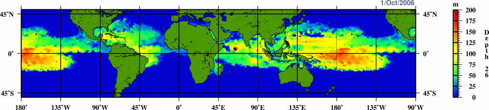
 Normally, an ocean temperature of 26.5°C (79.7°F) spanning through at least a 50-metre depth is considered the minimum to maintain the special mesocyclone
that is the tropical cyclone
. These warm waters are needed to maintain the warm core that fuels tropical systems. This value is well above 16.1 °C (60.9 °F), the global average surface temperature of the oceans. However, this requirement can be considered only a general baseline because it assumes that the ambient atmospheric environment surrounding an area of disturbed weather presents average conditions.
Tropical cyclones are known to form even when normal conditions are not met. For example, cooler air temperatures at a higher altitude (e.g., at the 500 hPa
level, or 5.9 km) can lead to tropical cyclogenesis at lower water temperatures, as a certain lapse rate
is required to force the atmosphere to be unstable enough for convection. In a moist atmosphere, this lapse rate is 6.5 °C/km, while in an atmosphere with less than 100% relative humidity
, the required lapse rate is 9.8 °C/km.
At the 500 hPa level, the air temperature averages -7 °C (18 °F) within the tropics, but air in the tropics is normally dry at this level, giving the air room to wet-bulb
, or cool as it moistens, to a more favorable temperature that can then support convection. A wetbulb temperature at 500 hPa in a tropical atmosphere of -13.2 °C is required to initiate convection if the water temperature is 26.5 °C, and this temperature requirement increases or decreases proportionally by 1 °C in the sea surface temperature for each 1 °C change at 500 hpa.
Under a cold cyclone, 500 hPa temperatures can fall as low as -30 °C, which can initiate convection even in the driest atmospheres. This also explains why moisture in the mid-levels of the troposphere
, roughly at the 500 hPa level, is normally a requirement for development. However, when dry air is found at the same height, temperatures at 500 hPa need to be even colder as dry atmospheres require a greater lapse rate for instability than moist atmospheres. At heights near the tropopause
, the 30-year average temperature (as measured in the period encompassing 1961 through 1990) was -77 °C (-132 °F). A recent example of a tropical cyclone
that maintained itself over cooler waters was Epsilon of the 2005 Atlantic hurricane season
.
created a mathematical model
around 1988 to compute the upper limit of tropical cyclone intensity based on sea surface temperature and atmospheric profiles from the latest global model runs
. Emanuel's model is called the maximum potential intensity, or MPI. Maps created from this equation show regions where tropical storm and hurricane formation is possible, based upon the thermodynamics
of the atmosphere at the time of the last model run (either 0000 or 1200 UTC). This does not take into account vertical wind shear
.

is normally needed for tropical cyclogenesis. The Coriolis force imparts rotation on the flow and arises as winds begin to flow in toward the lower pressure created by the pre-existing disturbance. In areas with a very small or non-existent Coriolis force (e.g. near the Equator), the only significant atmospheric forces in play are the pressure gradient force (the pressure difference that causes winds to blow from high to low pressure ) and a smaller friction
force; these two alone would not cause the large-scale rotation required for tropical cyclogenesis. The existence of a significant Coriolis force allows the developing vortex to achieve gradient wind balance. This is a balance condition found in mature tropical cyclones that allows latent heat
to concentrate near the storm core; this results in the maintenance or intensification of the vortex if other development factors are neutral.
, a tropical wave
, a broad surface front
, or an outflow boundary
, a low level feature with sufficient vorticity and convergence is required to begin tropical cyclogenesis. Even with perfect upper level conditions and the required atmospheric instability, the lack of a surface focus will prevent the development of organized convection and a surface low.
(20 kt, 22 mph) between the surface and the tropopause
is required for tropical cyclone development. Strong wind shear can "blow" the tropical cyclone apart, as it displaces the mid-level warm core from the surface circulation and dries out the mid-levels of the troposphere
, halting development. In smaller systems, the development of a significant mesoscale convective complex
in a sheared environment can send out a large enough outflow boundary to destroy the surface cyclone. Moderate wind shear can lead to the initial development of the convective complex and surface low similar to the mid-latitudes, but it must relax to allow tropical cyclogenesis to continue.
or upper-level low is roughly the same scale as the tropical disturbance, the system can be steered by the upper level system into an area with better diffluence
aloft, which can cause further development. Weaker upper cyclones are better candidates for a favorable interaction. There is evidence that weakly sheared tropical cyclones initially develop more rapidly than non-sheared tropical cyclones, although this comes at the cost of a peak in intensity with much weaker wind speeds and higher minimum pressure
. This process is also known as baroclinic initiation of a tropical cyclone. Trailing upper cyclones and upper troughs can cause additional outflow channels and aid in the intensification process. It should be noted that developing tropical disturbances can help create or deepen upper troughs or upper lows in their wake due to the outflow jet emanating from the developing tropical disturbance/cyclone.
There are cases where large, mid-latitude troughs can help with tropical cyclogenesis when an upper-level jet stream
passes to the northwest of the developing system, which will aid divergence aloft and inflow at the surface, spinning up the cyclone. This type of interaction is more often associated with disturbances already in the process of recurvature.
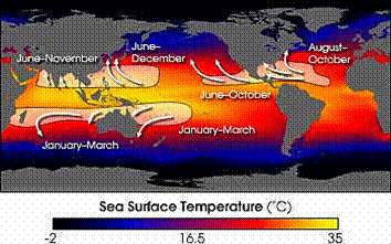 Worldwide, tropical cyclone activity peaks in late summer when water temperatures are warmest. Each basin, however, has its own seasonal patterns. On a worldwide scale, May is the least active month, while September is the most active.
In the North Atlantic
, a distinct hurricane season occurs from June 1 through November 30, sharply peaking from late August through October. The statistical peak of the North Atlantic hurricane season is September 10. The Northeast Pacific has a broader period of activity, but in a similar time frame to the Atlantic. The Northwest Pacific sees tropical cyclones year-round, with a minimum in February and a peak in early September. In the North Indian basin, storms are most common from April to December, with peaks in May and November.
In the Southern Hemisphere
, tropical cyclone activity begins in early November and depending on the country ends on either April 30 or May 15. Southern Hemisphere activity peaks in mid-February to early March. Virtually all the Southern Hemisphere activity is seen from the southern African coast eastward towards South America. Tropical cyclones are rare events across the south Atlantic ocean and the southeastern Pacific ocean.


, 1988
, and 1975, storms may form or strengthen in this region. Storms surviving beyond 50 degrees as a tropical cyclone are also quite rare (although it is not uncommon for a storm to become extratropical at high intensity in the high latitudes).
and a lack of tropical disturbances from the Intertropical Convergence Zone
(ITCZ) makes it very difficult for the South Atlantic to support tropical activity. Four tropical cyclones have been observed here — a weak tropical storm in 1991 off the coast of Africa
near Angola
, Cyclone Catarina
(sometimes also referred to as Aldonça), which made landfall in Brazil
in 2004 at Category 2 strength
, and a smaller storm in January 2004, east of Salvador, Brazil. The January storm is thought to have reached tropical storm intensity based on scatterometer
wind measurements. A weak tropical storm formed in 2006 and Tropical Storm Anita
became the first officially named cyclone in the South Atlantic in March 2010.
. Examples of these "Mediterranean tropical cyclones" formed in September 1947, September 1969, September 1973, August 1976, January 1982, September 1983, December 1984, December 1985, October 1994, January 1995, October 1996, September 1997, December 2005, September 2006, and November 2011. However, there is debate on whether these storms were tropical in nature. The Black Sea
has, on occasion, produced or fueled storms that begin cyclonic rotation, and appear to be similar to cyclones seen in the Mediterranean.
have been reported off the coast of Morocco
in the past. However, it is debatable if they are truly tropical in character. Tropical activity is also extremely rare in the Great Lakes
. However, a storm system that appeared similar to a subtropical or tropical cyclone formed in 1996 on Lake Huron
. It formed an eye
-like structure in its center, and it may have briefly been a subtropical or tropical cyclone.
 Warm waters during the El Niño-Southern Oscillation
lower the potential of tropical cyclone formation primarily in the Atlantic Basin
and around Australia. Because tropical cyclones in the northeastern Pacific and north Atlantic basins are both generated in large part by tropical wave
s from the same wave train, decreased tropical cyclone activity in the north Atlantic translates to increased tropical cyclone activity in the Eastern North Pacific.
In the Northwestern Pacific, El Niño shifts the formation of tropical cyclones eastward. During El Niño episodes, tropical cyclones tend to form in the eastern part of the basin, between 150°E
and the International Date Line
(IDL). Coupled with an increase in activity in the North-Central Pacific (IDL to 140°W
) and the South-Central Pacific (east of 160°E
), there is a net increase in tropical cyclone development near the International Date Line on both sides of the equator. While there is no linear relationship between the strength of an El Niño and tropical cyclone formation in the Northwestern Pacific, typhoons forming during El Niño years tend to have a longer duration and higher intensities. Tropical cyclogenesis in the Northwestern Pacific is suppressed west of 150°E in the year following an El Niño event.
In general, westerly wind increases associated with the Madden-Julian Oscillation
lead to increased tropical cyclogenesis in all basins. As the oscillation propagates from west to east, it leads to an eastward march in tropical cyclogenesis with time during that hemisphere's summer season. There is an inverse relationship between tropical cyclone activity in the western Pacific basin and the north Atlantic basin, however. When one basin is active, the other is normally quiet, and vice versa. The main reason for this appears to be the phase of the Madden-Julian oscillation
, or MJO, which is normally in opposite modes between the two basins at any given time.
packets can increase the likelihood of tropical cyclogenesis in the Pacific Ocean
, as they increase the low-level westerly winds
within that region, which then leads to greater low-level vorticity. The individual waves can move at approximately 1.8 m/s (4 mph) each, though the group tends to remain stationary.
has been issuing seasonal tropical cyclone forecasts for the north Atlantic basin, with results that are better than climatology. The university has found several statistical relationships for this basin that appear to allow long range prediction of the number of tropical cyclones. Since then, numerous others have followed in the university's steps, with some organizations issuing seasonal forecasts for the northwest Pacific and the Australian region. The predictors are related to regional oscillations in the global climate
system: the Walker circulation
which is related to the El Niño-Southern Oscillation
; the North Atlantic oscillation
or NAO; the Arctic oscillation
or AO; and the Pacific North American pattern or PNA.
Tropical cyclone
A tropical cyclone is a storm system characterized by a large low-pressure center and numerous thunderstorms that produce strong winds and heavy rain. Tropical cyclones strengthen when water evaporated from the ocean is released as the saturated air rises, resulting in condensation of water vapor...
in the atmosphere
Atmosphere
An atmosphere is a layer of gases that may surround a material body of sufficient mass, and that is held in place by the gravity of the body. An atmosphere may be retained for a longer duration, if the gravity is high and the atmosphere's temperature is low...
. The mechanisms through which tropical cyclogenesis occurs are distinctly different from those through which mid-latitude
Latitude
In geography, the latitude of a location on the Earth is the angular distance of that location south or north of the Equator. The latitude is an angle, and is usually measured in degrees . The equator has a latitude of 0°, the North pole has a latitude of 90° north , and the South pole has a...
cyclogenesis occurs. Tropical cyclogenesis involves the development of a warm-core cyclone, due to significant convection
Convection
Convection is the movement of molecules within fluids and rheids. It cannot take place in solids, since neither bulk current flows nor significant diffusion can take place in solids....
in a favorable atmospheric environment. There are six main requirements for tropical cyclogenesis: sufficiently warm sea surface temperatures, atmospheric instability, high humidity
Humidity
Humidity is a term for the amount of water vapor in the air, and can refer to any one of several measurements of humidity. Formally, humid air is not "moist air" but a mixture of water vapor and other constituents of air, and humidity is defined in terms of the water content of this mixture,...
in the lower to middle levels of the troposphere
Troposphere
The troposphere is the lowest portion of Earth's atmosphere. It contains approximately 80% of the atmosphere's mass and 99% of its water vapor and aerosols....
, enough Coriolis force to develop a low pressure center, a preexisting low level focus or disturbance, and low vertical wind shear
Wind shear
Wind shear, sometimes referred to as windshear or wind gradient, is a difference in wind speed and direction over a relatively short distance in the atmosphere...
.
Tropical cyclones tend to develop during the summer, but have been noted in nearly every month in most basins. Climate
Climate
Climate encompasses the statistics of temperature, humidity, atmospheric pressure, wind, rainfall, atmospheric particle count and other meteorological elemental measurements in a given region over long periods...
cycles such as ENSO
Enso
Ensō is a Japanese word meaning "circle" and a concept strongly associated with Zen. Ensō is one of the most common subjects of Japanese calligraphy even though it is a symbol and not a character. It symbolizes the Absolute enlightenment, strength, elegance, the Universe, and the void; it can...
and the Madden-Julian Oscillation
Madden-Julian oscillation
The Madden–Julian oscillation ' is the largest element of the intraseasonal variability in the tropical atmosphere. It is a large-scale coupling between atmospheric circulation and tropical deep convection...
modulate the timing and frequency of tropical cyclone development. There is a limit on tropical cyclone intensity which is strongly related to the water temperatures along its path. An average of 86 tropical cyclones of tropical storm intensity form annually worldwide. Of those, 47 reach hurricane/typhoon strength, and 20 become intense tropical cyclones (at least Category 3 intensity on the Saffir-Simpson Hurricane Scale
Saffir-Simpson Hurricane Scale
The Saffir–Simpson Hurricane Scale , or the Saffir–Simpson Hurricane Wind Scale , classifies hurricanes — Western Hemisphere tropical cyclones that exceed the intensities of tropical depressions and tropical storms — into five categories distinguished by the intensities of their sustained winds...
).
Requirements for tropical cyclone formation
Humidity
Humidity is a term for the amount of water vapor in the air, and can refer to any one of several measurements of humidity. Formally, humid air is not "moist air" but a mixture of water vapor and other constituents of air, and humidity is defined in terms of the water content of this mixture,...
in the lower to middle levels of the troposphere
Troposphere
The troposphere is the lowest portion of Earth's atmosphere. It contains approximately 80% of the atmosphere's mass and 99% of its water vapor and aerosols....
, enough Coriolis force to sustain a low pressure center, a preexisting low level focus or disturbance, and low vertical wind shear
Wind shear
Wind shear, sometimes referred to as windshear or wind gradient, is a difference in wind speed and direction over a relatively short distance in the atmosphere...
. While these conditions are necessary for tropical cyclone formation, they do not guarantee that a tropical cyclone will form.
Warm waters, instability, and mid-level moisture
Mesocyclone
A mesocyclone is a vortex of air, approximately 2 to 10 miles in diameter , within a convective storm....
that is the tropical cyclone
Tropical cyclone
A tropical cyclone is a storm system characterized by a large low-pressure center and numerous thunderstorms that produce strong winds and heavy rain. Tropical cyclones strengthen when water evaporated from the ocean is released as the saturated air rises, resulting in condensation of water vapor...
. These warm waters are needed to maintain the warm core that fuels tropical systems. This value is well above 16.1 °C (60.9 °F), the global average surface temperature of the oceans. However, this requirement can be considered only a general baseline because it assumes that the ambient atmospheric environment surrounding an area of disturbed weather presents average conditions.
Tropical cyclones are known to form even when normal conditions are not met. For example, cooler air temperatures at a higher altitude (e.g., at the 500 hPa
HPA
-Organizations:*Halifax Port Authority, a port authority in Canada*Hamburg Port Authority, the port authority for the Port of Hamburg, Germany*Health Protection Agency, a health organization in the United Kingdom...
level, or 5.9 km) can lead to tropical cyclogenesis at lower water temperatures, as a certain lapse rate
Lapse rate
The lapse rate is defined as the rate of decrease with height for an atmospheric variable. The variable involved is temperature unless specified otherwise. The terminology arises from the word lapse in the sense of a decrease or decline; thus, the lapse rate is the rate of decrease with height and...
is required to force the atmosphere to be unstable enough for convection. In a moist atmosphere, this lapse rate is 6.5 °C/km, while in an atmosphere with less than 100% relative humidity
Relative humidity
Relative humidity is a term used to describe the amount of water vapor in a mixture of air and water vapor. It is defined as the partial pressure of water vapor in the air-water mixture, given as a percentage of the saturated vapor pressure under those conditions...
, the required lapse rate is 9.8 °C/km.
At the 500 hPa level, the air temperature averages -7 °C (18 °F) within the tropics, but air in the tropics is normally dry at this level, giving the air room to wet-bulb
Wet-bulb temperature
The wet-bulb temperature is a type of temperature measurement that reflects the physical properties of a system with a mixture of a gas and a vapor, usually air and water vapor. Wet bulb temperature is the lowest temperature that can be reached by the evaporation of water only. It is the...
, or cool as it moistens, to a more favorable temperature that can then support convection. A wetbulb temperature at 500 hPa in a tropical atmosphere of -13.2 °C is required to initiate convection if the water temperature is 26.5 °C, and this temperature requirement increases or decreases proportionally by 1 °C in the sea surface temperature for each 1 °C change at 500 hpa.
Under a cold cyclone, 500 hPa temperatures can fall as low as -30 °C, which can initiate convection even in the driest atmospheres. This also explains why moisture in the mid-levels of the troposphere
Troposphere
The troposphere is the lowest portion of Earth's atmosphere. It contains approximately 80% of the atmosphere's mass and 99% of its water vapor and aerosols....
, roughly at the 500 hPa level, is normally a requirement for development. However, when dry air is found at the same height, temperatures at 500 hPa need to be even colder as dry atmospheres require a greater lapse rate for instability than moist atmospheres. At heights near the tropopause
Tropopause
The tropopause is the atmospheric boundary between the troposphere and the stratosphere.-Definition:Going upward from the surface, it is the point where air ceases to cool with height, and becomes almost completely dry...
, the 30-year average temperature (as measured in the period encompassing 1961 through 1990) was -77 °C (-132 °F). A recent example of a tropical cyclone
Tropical cyclone
A tropical cyclone is a storm system characterized by a large low-pressure center and numerous thunderstorms that produce strong winds and heavy rain. Tropical cyclones strengthen when water evaporated from the ocean is released as the saturated air rises, resulting in condensation of water vapor...
that maintained itself over cooler waters was Epsilon of the 2005 Atlantic hurricane season
2005 Atlantic hurricane season
The 2005 Atlantic hurricane season was the most active Atlantic hurricane season in recorded history, repeatedly shattering numerous records. The impact of the season was widespread and ruinous with an estimated 3,913 deaths and record damage of about $159.2 billion...
.
Role of Maximum Potential Intensity (MPI)
Kerry EmanuelKerry Emanuel
Kerry Emanuel is an American professor of meteorology currently working at the Massachusetts Institute of Technology in Cambridge. In particular he has specialized in atmospheric convection and the mechanisms acting to intensify hurricanes. He coined the term "hypercane" in 1994. In 2007, he was...
created a mathematical model
Mathematical model
A mathematical model is a description of a system using mathematical concepts and language. The process of developing a mathematical model is termed mathematical modeling. Mathematical models are used not only in the natural sciences and engineering disciplines A mathematical model is a...
around 1988 to compute the upper limit of tropical cyclone intensity based on sea surface temperature and atmospheric profiles from the latest global model runs
Tropical cyclone prediction model
A tropical cyclone forecast model is a computer program that uses meteorological data to forecast aspects of the future state of tropical cyclones. There are three types of models: statistical, dynamical, or combined statistical-dynamic...
. Emanuel's model is called the maximum potential intensity, or MPI. Maps created from this equation show regions where tropical storm and hurricane formation is possible, based upon the thermodynamics
Thermodynamics
Thermodynamics is a physical science that studies the effects on material bodies, and on radiation in regions of space, of transfer of heat and of work done on or by the bodies or radiation...
of the atmosphere at the time of the last model run (either 0000 or 1200 UTC). This does not take into account vertical wind shear
Wind shear
Wind shear, sometimes referred to as windshear or wind gradient, is a difference in wind speed and direction over a relatively short distance in the atmosphere...
.
Coriolis force
A minimum distance of 500 km (310.7 mi) from the equatorEquator
An equator is the intersection of a sphere's surface with the plane perpendicular to the sphere's axis of rotation and containing the sphere's center of mass....
is normally needed for tropical cyclogenesis. The Coriolis force imparts rotation on the flow and arises as winds begin to flow in toward the lower pressure created by the pre-existing disturbance. In areas with a very small or non-existent Coriolis force (e.g. near the Equator), the only significant atmospheric forces in play are the pressure gradient force (the pressure difference that causes winds to blow from high to low pressure ) and a smaller friction
Friction
Friction is the force resisting the relative motion of solid surfaces, fluid layers, and/or material elements sliding against each other. There are several types of friction:...
force; these two alone would not cause the large-scale rotation required for tropical cyclogenesis. The existence of a significant Coriolis force allows the developing vortex to achieve gradient wind balance. This is a balance condition found in mature tropical cyclones that allows latent heat
Latent heat
Latent heat is the heat released or absorbed by a chemical substance or a thermodynamic system during a process that occurs without a change in temperature. A typical example is a change of state of matter, meaning a phase transition such as the melting of ice or the boiling of water. The term was...
to concentrate near the storm core; this results in the maintenance or intensification of the vortex if other development factors are neutral.
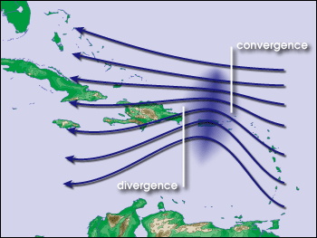
Low level disturbance
Whether it be a depression in the intertropical covergence zone (ITCZ)Intertropical Convergence Zone
The Intertropical Convergence Zone , known by sailors as The Doldrums, is the area encircling the earth near the equator where winds originating in the northern and southern hemispheres come together....
, a tropical wave
Tropical wave
Tropical waves, easterly waves, or tropical easterly waves, also known as African easterly waves in the Atlantic region, are a type of atmospheric trough, an elongated area of relatively low air pressure, oriented north to south, which move from east to west across the tropics causing areas of...
, a broad surface front
Surface weather analysis
Surface weather analysis is a special type of weather map that provides a view of weather elements over a geographical area at a specified time based on information from ground-based weather stations...
, or an outflow boundary
Outflow boundary
An outflow boundary, also known as a gust front, is a storm-scale or mesoscale boundary separating thunderstorm-cooled air from the surrounding air; similar in effect to a cold front, with passage marked by a wind shift and usually a drop in temperature and a related pressure jump...
, a low level feature with sufficient vorticity and convergence is required to begin tropical cyclogenesis. Even with perfect upper level conditions and the required atmospheric instability, the lack of a surface focus will prevent the development of organized convection and a surface low.
Weak vertical wind shear
Vertical wind shear of less than 10 m/sMetre per second
Metre per second is an SI derived unit of both speed and velocity , defined by distance in metres divided by time in seconds....
(20 kt, 22 mph) between the surface and the tropopause
Tropopause
The tropopause is the atmospheric boundary between the troposphere and the stratosphere.-Definition:Going upward from the surface, it is the point where air ceases to cool with height, and becomes almost completely dry...
is required for tropical cyclone development. Strong wind shear can "blow" the tropical cyclone apart, as it displaces the mid-level warm core from the surface circulation and dries out the mid-levels of the troposphere
Troposphere
The troposphere is the lowest portion of Earth's atmosphere. It contains approximately 80% of the atmosphere's mass and 99% of its water vapor and aerosols....
, halting development. In smaller systems, the development of a significant mesoscale convective complex
Mesoscale Convective Complex
A mesoscale convective complex is a unique kind of mesoscale convective system which is defined by characteristics observed in infrared satellite imagery. They are long-lived, nocturnal in formation and commonly contain heavy rainfall, wind, hail, lightning and possibly tornadoes.-Size:A...
in a sheared environment can send out a large enough outflow boundary to destroy the surface cyclone. Moderate wind shear can lead to the initial development of the convective complex and surface low similar to the mid-latitudes, but it must relax to allow tropical cyclogenesis to continue.
Favorable trough interactions
Limited vertical wind shear can be positive for tropical cyclone formation. When an upper-level troughTrough (meteorology)
A trough is an elongated region of relatively low atmospheric pressure, often associated with fronts.Unlike fronts, there is not a universal symbol for a trough on a weather chart. The weather charts in some countries or regions mark troughs by a line. In the United States, a trough may be marked...
or upper-level low is roughly the same scale as the tropical disturbance, the system can be steered by the upper level system into an area with better diffluence
Divergence
In vector calculus, divergence is a vector operator that measures the magnitude of a vector field's source or sink at a given point, in terms of a signed scalar. More technically, the divergence represents the volume density of the outward flux of a vector field from an infinitesimal volume around...
aloft, which can cause further development. Weaker upper cyclones are better candidates for a favorable interaction. There is evidence that weakly sheared tropical cyclones initially develop more rapidly than non-sheared tropical cyclones, although this comes at the cost of a peak in intensity with much weaker wind speeds and higher minimum pressure
Atmospheric pressure
Atmospheric pressure is the force per unit area exerted into a surface by the weight of air above that surface in the atmosphere of Earth . In most circumstances atmospheric pressure is closely approximated by the hydrostatic pressure caused by the weight of air above the measurement point...
. This process is also known as baroclinic initiation of a tropical cyclone. Trailing upper cyclones and upper troughs can cause additional outflow channels and aid in the intensification process. It should be noted that developing tropical disturbances can help create or deepen upper troughs or upper lows in their wake due to the outflow jet emanating from the developing tropical disturbance/cyclone.
There are cases where large, mid-latitude troughs can help with tropical cyclogenesis when an upper-level jet stream
Jet stream
Jet streams are fast flowing, narrow air currents found in the atmospheres of some planets, including Earth. The main jet streams are located near the tropopause, the transition between the troposphere and the stratosphere . The major jet streams on Earth are westerly winds...
passes to the northwest of the developing system, which will aid divergence aloft and inflow at the surface, spinning up the cyclone. This type of interaction is more often associated with disturbances already in the process of recurvature.
Times of formation
In the North Atlantic
Atlantic Ocean
The Atlantic Ocean is the second-largest of the world's oceanic divisions. With a total area of about , it covers approximately 20% of the Earth's surface and about 26% of its water surface area...
, a distinct hurricane season occurs from June 1 through November 30, sharply peaking from late August through October. The statistical peak of the North Atlantic hurricane season is September 10. The Northeast Pacific has a broader period of activity, but in a similar time frame to the Atlantic. The Northwest Pacific sees tropical cyclones year-round, with a minimum in February and a peak in early September. In the North Indian basin, storms are most common from April to December, with peaks in May and November.
In the Southern Hemisphere
Southern Hemisphere
The Southern Hemisphere is the part of Earth that lies south of the equator. The word hemisphere literally means 'half ball' or "half sphere"...
, tropical cyclone activity begins in early November and depending on the country ends on either April 30 or May 15. Southern Hemisphere activity peaks in mid-February to early March. Virtually all the Southern Hemisphere activity is seen from the southern African coast eastward towards South America. Tropical cyclones are rare events across the south Atlantic ocean and the southeastern Pacific ocean.
| Basin | Season start |
Season end |
Tropical Storms |
Tropical Cyclones |
Refs |
|---|---|---|---|---|---|
| 1 North Atlantic | 3 June | 3 November | 10.3 | 6.2 | |
| 2 Eastern Pacific | 2 May | 3 November | 15 | 9 | |
| 3 Western Pacific | 1 January | 4 December | 25.7 | 16.0 | |
| 4 North Indian | 1 January | 4 December | 5.4 | 2.5 | |
| 5 South-West Indian | 4 November | 2 May | 10.4 | 4.4 | |
| 6 Australian region | 4 November | 1 April | 12 | ||
| 7 Southern Pacific | 4 November | 1 April | 8.9 | 4.3 |
Unusual areas of formation
Middle latitudes
Areas farther than 30 degrees from the equator (except in the vicinity of a warm current) are not normally conducive to tropical cyclone formation or strengthening, and areas more than 40 degrees from the equator are often very hostile to such development. The primary limiting factor is water temperatures, although higher shear at increasing latitudes is also a factor. These areas are sometimes frequented by cyclones moving poleward from tropical latitudes. On rare occasions, such as in 2004Hurricane Alex (2004)
Hurricane Alex was the first named storm, the first hurricane, and the first major hurricane of the 2004 Atlantic hurricane season. The first storm of the season, Alex formed unusually late in the season; the fifth latest since 1954. It developed from the interaction between an upper-level low and...
, 1988
Tropical Storm Alberto (1988)
Tropical Storm Alberto was a tropical cyclone of the 1988 Atlantic hurricane season that became a tropical storm unusually far north. Alberto developed from a trough of low pressure off the coast of South Carolina on August 5...
, and 1975, storms may form or strengthen in this region. Storms surviving beyond 50 degrees as a tropical cyclone are also quite rare (although it is not uncommon for a storm to become extratropical at high intensity in the high latitudes).
Near the Equator
Areas within approximately ten degrees latitude of the equator do not experience a significant Coriolis Force, a vital ingredient in tropical cyclone formation. However, recently a few tropical cyclones have been observed forming within five degrees of the equator.South Atlantic
A combination of wind shearWind shear
Wind shear, sometimes referred to as windshear or wind gradient, is a difference in wind speed and direction over a relatively short distance in the atmosphere...
and a lack of tropical disturbances from the Intertropical Convergence Zone
Intertropical Convergence Zone
The Intertropical Convergence Zone , known by sailors as The Doldrums, is the area encircling the earth near the equator where winds originating in the northern and southern hemispheres come together....
(ITCZ) makes it very difficult for the South Atlantic to support tropical activity. Four tropical cyclones have been observed here — a weak tropical storm in 1991 off the coast of Africa
Africa
Africa is the world's second largest and second most populous continent, after Asia. At about 30.2 million km² including adjacent islands, it covers 6% of the Earth's total surface area and 20.4% of the total land area...
near Angola
Angola
Angola, officially the Republic of Angola , is a country in south-central Africa bordered by Namibia on the south, the Democratic Republic of the Congo on the north, and Zambia on the east; its west coast is on the Atlantic Ocean with Luanda as its capital city...
, Cyclone Catarina
Cyclone Catarina
Cyclone Catarina is one of several informal names for a South Atlantic tropical cyclone that hit southeastern Brazil in late March 2004. The storm developed out of a stationary cold-core upper-level trough on March 12...
(sometimes also referred to as Aldonça), which made landfall in Brazil
Brazil
Brazil , officially the Federative Republic of Brazil , is the largest country in South America. It is the world's fifth largest country, both by geographical area and by population with over 192 million people...
in 2004 at Category 2 strength
Saffir-Simpson Hurricane Scale
The Saffir–Simpson Hurricane Scale , or the Saffir–Simpson Hurricane Wind Scale , classifies hurricanes — Western Hemisphere tropical cyclones that exceed the intensities of tropical depressions and tropical storms — into five categories distinguished by the intensities of their sustained winds...
, and a smaller storm in January 2004, east of Salvador, Brazil. The January storm is thought to have reached tropical storm intensity based on scatterometer
Scatterometer
A radar scatterometer is designed to determine the normalized radar cross section of the surface. Scatterometers operate by transmitting a pulse of microwave energy towards the Earth's surface and measuring the reflected energy. A separate measurement of the noise-only power is made and...
wind measurements. A weak tropical storm formed in 2006 and Tropical Storm Anita
Tropical Storm Anita (2010)
Tropical Storm Anita was the second tropical cyclone in the Southern Atlantic Ocean on record, following Cyclone Catarina in March 2004. Originating from an extratropical cyclone over southern Brazil, this system quickly moved offshore, entering a region favoring subtropical development...
became the first officially named cyclone in the South Atlantic in March 2010.
Mediterranean Sea
Storms that appear similar to tropical cyclones in structure sometimes occur in the Mediterranean basinMediterranean Sea
The Mediterranean Sea is a sea connected to the Atlantic Ocean surrounded by the Mediterranean region and almost completely enclosed by land: on the north by Anatolia and Europe, on the south by North Africa, and on the east by the Levant...
. Examples of these "Mediterranean tropical cyclones" formed in September 1947, September 1969, September 1973, August 1976, January 1982, September 1983, December 1984, December 1985, October 1994, January 1995, October 1996, September 1997, December 2005, September 2006, and November 2011. However, there is debate on whether these storms were tropical in nature. The Black Sea
Black Sea
The Black Sea is bounded by Europe, Anatolia and the Caucasus and is ultimately connected to the Atlantic Ocean via the Mediterranean and the Aegean seas and various straits. The Bosphorus strait connects it to the Sea of Marmara, and the strait of the Dardanelles connects that sea to the Aegean...
has, on occasion, produced or fueled storms that begin cyclonic rotation, and appear to be similar to cyclones seen in the Mediterranean.
Elsewhere
VorticesVortex
A vortex is a spinning, often turbulent,flow of fluid. Any spiral motion with closed streamlines is vortex flow. The motion of the fluid swirling rapidly around a center is called a vortex...
have been reported off the coast of Morocco
Morocco
Morocco , officially the Kingdom of Morocco , is a country located in North Africa. It has a population of more than 32 million and an area of 710,850 km², and also primarily administers the disputed region of the Western Sahara...
in the past. However, it is debatable if they are truly tropical in character. Tropical activity is also extremely rare in the Great Lakes
Great Lakes
The Great Lakes are a collection of freshwater lakes located in northeastern North America, on the Canada – United States border. Consisting of Lakes Superior, Michigan, Huron, Erie, and Ontario, they form the largest group of freshwater lakes on Earth by total surface, coming in second by volume...
. However, a storm system that appeared similar to a subtropical or tropical cyclone formed in 1996 on Lake Huron
Lake Huron
Lake Huron is one of the five Great Lakes of North America. Hydrologically, it comprises the larger portion of Lake Michigan-Huron. It is bounded on the east by the Canadian province of Ontario and on the west by the state of Michigan in the United States...
. It formed an eye
Eye (cyclone)
The eye is a region of mostly calm weather found at the center of strong tropical cyclones. The eye of a storm is a roughly circular area and typically 30–65 km in diameter. It is surrounded by the eyewall, a ring of towering thunderstorms where the second most severe weather of a cyclone...
-like structure in its center, and it may have briefly been a subtropical or tropical cyclone.
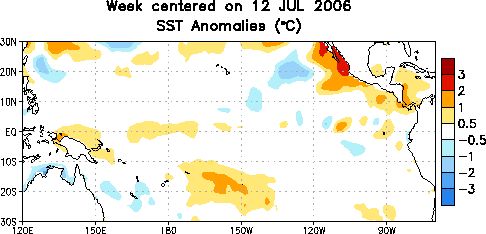
Influence of ENSO
El Niño-Southern Oscillation
El Niño/La Niña-Southern Oscillation, or ENSO, is a quasiperiodic climate pattern that occurs across the tropical Pacific Ocean roughly every five years...
lower the potential of tropical cyclone formation primarily in the Atlantic Basin
Atlantic Ocean
The Atlantic Ocean is the second-largest of the world's oceanic divisions. With a total area of about , it covers approximately 20% of the Earth's surface and about 26% of its water surface area...
and around Australia. Because tropical cyclones in the northeastern Pacific and north Atlantic basins are both generated in large part by tropical wave
Tropical wave
Tropical waves, easterly waves, or tropical easterly waves, also known as African easterly waves in the Atlantic region, are a type of atmospheric trough, an elongated area of relatively low air pressure, oriented north to south, which move from east to west across the tropics causing areas of...
s from the same wave train, decreased tropical cyclone activity in the north Atlantic translates to increased tropical cyclone activity in the Eastern North Pacific.
In the Northwestern Pacific, El Niño shifts the formation of tropical cyclones eastward. During El Niño episodes, tropical cyclones tend to form in the eastern part of the basin, between 150°E
150th meridian east
The meridian 150° east of Greenwich is a line of longitude that extends from the North Pole across the Arctic Ocean, Asia, the Pacific Ocean, Australasia, the Southern Ocean, and Antarctica to the South Pole....
and the International Date Line
International Date Line
The International Date Line is a generally north-south imaginary line on the surface of the Earth, passing through the middle of the Pacific Ocean, that designates the place where each calendar day begins...
(IDL). Coupled with an increase in activity in the North-Central Pacific (IDL to 140°W
140th meridian west
The meridian 140° west of Greenwich is a line of longitude that extends from the North Pole across the Arctic Ocean, North America, the Pacific Ocean, the Southern Ocean, and Antarctica to the South Pole....
) and the South-Central Pacific (east of 160°E
160th meridian east
The meridian 160° east of Greenwich is a line of longitude that extends from the North Pole across the Arctic Ocean, Asia, the Pacific Ocean, the Southern Ocean, and Antarctica to the South Pole....
), there is a net increase in tropical cyclone development near the International Date Line on both sides of the equator. While there is no linear relationship between the strength of an El Niño and tropical cyclone formation in the Northwestern Pacific, typhoons forming during El Niño years tend to have a longer duration and higher intensities. Tropical cyclogenesis in the Northwestern Pacific is suppressed west of 150°E in the year following an El Niño event.
Influence of the MJO
In general, westerly wind increases associated with the Madden-Julian Oscillation
Madden-Julian oscillation
The Madden–Julian oscillation ' is the largest element of the intraseasonal variability in the tropical atmosphere. It is a large-scale coupling between atmospheric circulation and tropical deep convection...
lead to increased tropical cyclogenesis in all basins. As the oscillation propagates from west to east, it leads to an eastward march in tropical cyclogenesis with time during that hemisphere's summer season. There is an inverse relationship between tropical cyclone activity in the western Pacific basin and the north Atlantic basin, however. When one basin is active, the other is normally quiet, and vice versa. The main reason for this appears to be the phase of the Madden-Julian oscillation
Madden-Julian oscillation
The Madden–Julian oscillation ' is the largest element of the intraseasonal variability in the tropical atmosphere. It is a large-scale coupling between atmospheric circulation and tropical deep convection...
, or MJO, which is normally in opposite modes between the two basins at any given time.
Influence of equatorial Rossby waves
Research has shown that trapped equatorial Rossby waveRossby wave
Atmospheric Rossby waves are giant meanders in high-altitude winds that are a major influence on weather.They are not to be confused with oceanic Rossby waves, which move along the thermocline: that is, the boundary between the warm upper layer of the ocean and the cold deeper part of the...
packets can increase the likelihood of tropical cyclogenesis in the Pacific Ocean
Pacific Ocean
The Pacific Ocean is the largest of the Earth's oceanic divisions. It extends from the Arctic in the north to the Southern Ocean in the south, bounded by Asia and Australia in the west, and the Americas in the east.At 165.2 million square kilometres in area, this largest division of the World...
, as they increase the low-level westerly winds
Westerlies
The Westerlies, anti-trades, or Prevailing Westerlies, are the prevailing winds in the middle latitudes between 30 and 60 degrees latitude, blowing from the high pressure area in the horse latitudes towards the poles. These prevailing winds blow from the west to the east, and steer extratropical...
within that region, which then leads to greater low-level vorticity. The individual waves can move at approximately 1.8 m/s (4 mph) each, though the group tends to remain stationary.
Seasonal forecasts
Since 1984, Colorado State UniversityColorado State University
Colorado State University is a public research university located in Fort Collins, Colorado. The university is the state's land grant university, and the flagship university of the Colorado State University System.The enrollment is approximately 29,932 students, including resident and...
has been issuing seasonal tropical cyclone forecasts for the north Atlantic basin, with results that are better than climatology. The university has found several statistical relationships for this basin that appear to allow long range prediction of the number of tropical cyclones. Since then, numerous others have followed in the university's steps, with some organizations issuing seasonal forecasts for the northwest Pacific and the Australian region. The predictors are related to regional oscillations in the global climate
Climate
Climate encompasses the statistics of temperature, humidity, atmospheric pressure, wind, rainfall, atmospheric particle count and other meteorological elemental measurements in a given region over long periods...
system: the Walker circulation
Walker circulation
The Walker circulation, also known as the Walker cell, is a conceptual model of the air flow in the tropics in the lower atmosphere . According to this model parcels of air follow a closed circulation in the zonal and vertical directions...
which is related to the El Niño-Southern Oscillation
El Niño-Southern Oscillation
El Niño/La Niña-Southern Oscillation, or ENSO, is a quasiperiodic climate pattern that occurs across the tropical Pacific Ocean roughly every five years...
; the North Atlantic oscillation
North Atlantic oscillation
The North Atlantic oscillation is a climatic phenomenon in the North Atlantic Ocean of fluctuations in the difference of atmospheric pressure at sea level between the Icelandic low and the Azores high. Through east-west oscillation motions of the Icelandic low and the Azores high, it controls the...
or NAO; the Arctic oscillation
Arctic oscillation
The Arctic oscillation or Northern Annular Mode/Northern Hemisphere Annular Mode is an index of the dominant pattern of non-seasonal sea-level pressure variations north of 20N latitude, and it is characterized by pressure anomalies of one sign in the Arctic with the opposite anomalies centered...
or AO; and the Pacific North American pattern or PNA.
See also
- Tropical cyclone forecastingTropical cyclone forecastingTropical cyclone forecasting is the science and art of forecasting where a tropical cyclone's center, and its effects, are expected to be at some point in the future. There are several elements to tropical cyclone forecasting: track forecasting, intensity forecasting, rainfall forecasting, storm...
- Rossby waveRossby waveAtmospheric Rossby waves are giant meanders in high-altitude winds that are a major influence on weather.They are not to be confused with oceanic Rossby waves, which move along the thermocline: that is, the boundary between the warm upper layer of the ocean and the cold deeper part of the...
- Tropical cycloneTropical cycloneA tropical cyclone is a storm system characterized by a large low-pressure center and numerous thunderstorms that produce strong winds and heavy rain. Tropical cyclones strengthen when water evaporated from the ocean is released as the saturated air rises, resulting in condensation of water vapor...
- Tropical waveTropical waveTropical waves, easterly waves, or tropical easterly waves, also known as African easterly waves in the Atlantic region, are a type of atmospheric trough, an elongated area of relatively low air pressure, oriented north to south, which move from east to west across the tropics causing areas of...
- Intertropical convergence zoneIntertropical Convergence ZoneThe Intertropical Convergence Zone , known by sailors as The Doldrums, is the area encircling the earth near the equator where winds originating in the northern and southern hemispheres come together....
- Monsoon troughMonsoon troughThe monsoon trough is that portion of the Intertropical Convergence Zone which extends into or through a monsoon circulation, as depicted by a line on a weather map showing the locations of minimum sea level pressure, and as such, is a convergence zone between the wind patterns of the southern and...
- Invest (meteorology)Invest (meteorology)An invest in meteorology is a designated area of disturbed weather that is being monitored for tropical cyclone development. Invests are designated by three separate forecast centers: the National Hurricane Center, Central Pacific Hurricane Center and Joint Typhoon Warning Center...