

Climate change
Encyclopedia
Climate change is a significant and lasting change in the statistical distribution of weather
patterns over periods
ranging from decades to millions of years. It may be a change in average weather conditions or the distribution of events around that average (e.g., more or fewer extreme weather events). Climate change may be limited to a specific region
or may occur across the whole Earth
.
The term sometimes is used to refer specifically to climate change caused by human activity, as opposed to changes in climate that may have resulted as part of Earth's natural processes.
In this latter sense, used especially in the context of environmental policy
, the term climate change today is synonymous with anthropogenic global warming
. Within scientific journals, however, global warming refers to surface temperature increases, while climate change includes global warming and everything else that increasing greenhouse gas amounts will affect.
Factors that can shape climate are called climate forcings or "forcing mechanisms". These include such processes as variations in solar radiation, deviations in the Earth's orbit
, mountain-building
and continental drift
, and changes in greenhouse gas
concentrations. There are a variety of climate change feedbacks that can either amplify or diminish the initial forcing. Some parts of the climate system, such as the oceans and ice caps, respond slowly in reaction to climate forcings, while others respond more quickly.
Forcing mechanisms can be either "internal" or "external". Internal forcing mechanisms are natural processes within the climate system itself (e.g., the meridional overturning circulation
). External forcing mechanisms can be either natural (e.g., changes in solar output) or anthropogenic (e.g., increased emissions of greenhouse gases).
Whether the initial forcing mechanism is internal or external, the response of the climate system might be fast (e.g., a sudden cooling due to airborne volcanic ash
reflecting sunlight), slow (e.g. thermal expansion
of warming ocean water), or a combination (e.g., sudden loss of albedo
in the arctic ocean as sea ice melts, followed by more gradual thermal expansion of the water). Therefore, the climate system can respond abruptly, but the full response to forcing mechanisms might not be fully developed for centuries or even longer.
Scientists generally define the five components of earth's climate system to include Atmosphere
, hydrosphere
, cryosphere
, lithosphere
(restricted to the surface soils, rocks, and sediments), and biosphere
.
is a fundamental part of the climate system, some changes in it occurring at longer timescales than in the atmosphere,
massing hundreds of times more and having very high thermal inertia
(such as the ocean depths still lagging today in temperature adjustment from the Little Ice Age
).
Short-term fluctuations (years to a few decades) such as the El Niño-Southern Oscillation
, the Pacific decadal oscillation
, the North Atlantic oscillation
, and the Arctic oscillation
, represent climate variability rather than climate change. On longer time scales, alterations to ocean processes such as thermohaline circulation
play a key role in redistributing heat by carrying out a very slow and extremely deep movement of water
, and the long-term redistribution of heat
in the world's oceans.
lead to changes in the seasonal distribution of sunlight reaching the Earth's surface and how it is distributed across the globe. There is very little change to the area-averaged annually averaged sunshine; but there can be strong changes in the geographical and seasonal distribution. The three types of orbital variations are variations in Earth's eccentricity
, changes in the tilt angle of Earth's axis of rotation
, and precession
of Earth's axis. Combined together, these produce Milankovitch cycles
which have a large impact on climate and are notable for their correlation to glacial
and interglacial periods, their correlation with the advance and retreat of the Sahara
, and for their appearance
in the stratigraphic record
.
The IPCC
notes that Milankovitch cycles drove the ice age cycles; CO2 followed temperature change "with a lag of some hundreds of years"; and that as a feedback amplified temperature change. The depths of the ocean have a lag time in changing temperature (thermal inertia on such scale). Upon seawater temperature change, the solubility of CO2 in the oceans changed, as well as other factors impacting air-sea CO2 exchange.
 The sun
is the predominant source for energy
input to the Earth. Both long- and short-term variations in solar intensity are known to affect global climate.
Three to four billion years ago the sun emitted only 70% as much power as it does today. If the atmospheric composition had been the same as today, liquid water should not have existed on Earth. However, there is evidence for the presence of water on the early Earth, in the Hadean
and Archean
eons, leading to what is known as the faint young Sun paradox
. Hypothesized solutions to this paradox include a vastly different atmosphere, with much higher concentrations of greenhouse gas
es than currently exist. Over the following approximately 4 billion years, the energy output of the sun increased and atmospheric composition changed. The Great Oxygenation Event
-oxygenation of the atmosphere- around 2.4 billion years ago was the most notable alteration. Over the next five billion years the sun's ultimate death as it becomes a red giant
and then a white dwarf
will have large effects on climate, with the red giant phase possibly ending any life on Earth that survives until that time.
Solar output also varies
on shorter time scales, including the 11-year solar cycle
and longer-term modulation
s. Solar intensity variations are considered to have been influential in triggering the Little Ice Age
, and some of the warming observed from 1900 to 1950. The cyclical nature of the sun's energy output is not yet fully understood; it differs from the very slow change that is happening within the sun as it ages and evolves. Research indicates that solar variability has had effects including the Maunder Minimum
from 1645 to 1715 A.D.
, part of the Little Ice Age
from 1550 to 1850 A.D.
which was marked by relative cooling and greater glacier extent than the centuries before and afterward. Some studies point toward solar radiation increases from cyclical sunspot activity affecting global warming, and climate may be influenced by the sum of all effects (solar variation
, anthropogenic radiative forcing
s, etc.).
Interestingly, a 2010 study suggests, “that the effects of solar variability on temperature throughout the atmosphere may be contrary to current expectations.”
In an Aug 2011 Press Release, CERN
announced the publication in the Nature
journal the initial results from its CLOUD
experiment. The results indicate that ionisation from cosmic rays significantly enhances aerosol formation in the presence of sulphuric acid and water, but in the lower atmosphere where ammonia is also required, this is insufficient to account for aerosol formation and additional trace vapours must be involved. The next step is to find more about these trace vapours, including whether they are of natural or human origin.
into the atmosphere. Eruption
s large enough to affect climate occur on average several times per century, and cause cooling (by partially blocking the transmission of solar radiation to the Earth's surface) for a period of a few years. The eruption of Mount Pinatubo
in 1991, the second largest terrestrial eruption of the 20th century (after the 1912 eruption of Novarupta
) affected the climate substantially. Global temperatures decreased by about 0.5 °C (0.9 °F). The eruption of Mount Tambora
in 1815 caused the Year Without a Summer
. Much larger eruptions, known as large igneous province
s, occur only a few times every hundred million years, but may cause global warming and mass extinctions.
Volcanoes are also part of the extended carbon cycle
. Over very long (geological) time periods, they release carbon dioxide from the Earth's crust and mantle, counteracting the uptake by sedimentary rocks and other geological carbon dioxide sink
s. The US Geological Survey estimates are that volcanic emissions are at a much lower level than than the effects of current human activities, which generate 100-300 times the amount of carbon dioxide emitted by volcanoes. A review of published studies indicates that annual volcanic emissions of carbon dioxide, including amounts released from mid-ocean ridges, volcanic arcs, and hot spot volcanoes, are only the equivalent of 3 to 5 days of human caused output. The annual amount put out by human activities may be greater than the amount released by supererruptions
, the most recent of which was the Toba eruption
in Indonesia 74,000 years ago.
Although volcanoes are technically part of the lithosphere, which itself is part of the climate system, the IPCC explicitly defines volcanism as an external forcing agent.
The position of the continents determines the geometry of the oceans and therefore influences patterns of ocean circulation. The locations of the seas are important in controlling the transfer of heat and moisture across the globe, and therefore, in determining global climate. A recent example of tectonic control on ocean circulation is the formation of the Isthmus of Panama
about 5 million years ago, which shut off direct mixing between the Atlantic and Pacific Oceans. This strongly affected the ocean dynamics of what is now the Gulf Stream
and may have led to Northern Hemisphere ice cover. During the Carboniferous
period, about 300 to 360 million years ago, plate tectonics may have triggered large-scale storage of carbon and increased glaciation. Geologic evidence points to a "megamonsoonal" circulation pattern during the time of the supercontinent
Pangaea
, and climate modeling suggests that the existence of the supercontinent was conducive to the establishment of monsoons.
The size of continents is also important. Because of the stabilizing effect of the oceans on temperature, yearly temperature variations are generally lower in coastal areas than they are inland. A larger supercontinent will therefore have more area in which climate is strongly seasonal than will several smaller continents or island
s.
is "that climate is changing and that these changes are in large part caused by human activities,"
and it "is largely irreversible."
Of most concern in these anthropogenic factors is the increase in CO2 levels due to emissions from fossil fuel
combustion, followed by aerosols (particulate matter in the atmosphere) and cement
manufacture. Other factors, including land use, ozone depletion
, animal agriculture and deforestation
, are also of concern in the roles they play - both separately and in conjunction with other factors - in affecting climate, microclimate
, and measures of climate variables.
, indicators that reflect climate, such as vegetation
, ice core
s, dendrochronology
, sea level change, and glacial geology.
from surface stations was supplemented by radiosonde balloons
, extensive atmospheric monitoring by the mid-20th century, and, from the 1970s on, with global satellite data
as well. The 18O/16O ratio in calcite and ice core samples used to deduce ocean temperature in the distant past
is an example of a temperature proxy method, as are other climate metrics noted in subsequent categories.
and historical documents can offer insights into past changes in the climate. Climate change effects have been linked to the collapse of various civilizations.
s are considered among the most sensitive indicators of climate change. Their size is determined by a mass balance
between snow input and melt output. As temperatures warm, glaciers retreat unless snow precipitation increases to make up for the additional melt; the converse is also true.
Glaciers grow and shrink due both to natural variability and external forcings. Variability in temperature, precipitation, and englacial and subglacial hydrology can strongly determine the evolution of a glacier in a particular season. Therefore, one must average over a decadal or longer time-scale and/or over a many individual glaciers to smooth out the local short-term variability and obtain a glacier history that is related to climate.
A world glacier inventory has been compiled since the 1970s, initially based mainly on aerial photographs and maps but now relying more on satellites. This compilation tracks more than 100,000 glaciers covering a total area of approximately 240,000 km2, and preliminary estimates indicate that the remaining ice cover is around 445,000 km2. The World Glacier Monitoring Service collects data annually on glacier retreat
and glacier mass balance
From this data, glaciers worldwide have been found to be shrinking significantly, with strong glacier retreats in the 1940s, stable or growing conditions during the 1920s and 1970s, and again retreating from the mid 1980s to present.
The most significant climate processes since the middle to late Pliocene
(approximately 3 million years ago) are the glacial and interglacial
cycles. The present interglacial period (the Holocene
) has lasted about 11,700 years. Shaped by orbital variations
, responses such as the rise and fall of continental
ice sheets and significant sea-level changes helped create the climate. Other changes, including Heinrich event
s, Dansgaard–Oeschger events and the Younger Dryas
, however, illustrate how glacial variations may also influence climate without the orbital forcing
.
Glaciers leave behind moraine
s that contain a wealth of material—including organic matter, quartz, and potassium that may be dated—recording the periods in which a glacier advanced and retreated. Similarly, by tephrochronological
techniques, the lack of glacier cover can be identified by the presence of soil or volcanic tephra
horizons whose date of deposit may also be ascertained.
, some sea ice remains year after year, whereas almost all Southern Ocean
or Antarctic sea ice melts away and reforms annually. Satellite observations show that Arctic sea ice is now declining at a rate of 11.5 percent per decade, relative to the 1979 to 2000 average.
(CRC), an extinction event 300 million years ago. At this time vast rainforests covered the equatorial region of Europe and America. Climate change devastated these tropical rainforests, abruptly fragmenting the habitat into isolated 'islands' and causing the extinction of many plant and animal species.
Satellite data available in recent decades indicates that global terrestrial net primary production increased by 6% from 1982 to 1999, with the largest portion of that increase in tropical ecosystems, then decreased by 1% from 2000 to 2009.
is the study of contemporary and fossil palynomorph
s, including pollen
. Palynology is used to infer the geographical distribution of plant species, which vary under different climate conditions. Different groups of plants have pollen
with distinctive shapes and surface textures, and since the outer surface of pollen is composed of a very resilient material, they resist decay. Changes in the type of pollen found in different layers of sediment in lakes, bogs, or river deltas indicate changes in plant communities. These changes are often a sign of a changing climate. As an example, palynological studies have been used to track changing vegetation patterns throughout the Quaternary glaciation
s and especially since the last glacial maximum
.
, satellite data has been available since the 1970s. Quantification of climatological variation of precipitation in prior centuries and epochs is less complete but approximated using proxies such as marine sediments, ice cores, cave stalagmites, and tree rings.
Climatological temperatures substantially affect precipitation. For instance, during the Last Glacial Maximum
of 18,000 years ago, thermal-driven evaporation
from the oceans onto continental landmasses was low, causing large areas of extreme desert, including polar desert
s (cold but with low rates of precipitation). In contrast, the world's climate was wetter than today near the start of the warm Atlantic Period of 8000 years ago.
Estimated global land precipitation increased by approximately 2% over the course of the 20th century, though the calculated trend varies if different time endpoints are chosen, complicated by ENSO
and other oscillations, including greater global land precipitation in the 1950s and 1970s than the later 1980s and 1990s despite the positive trend over the century overall.
Similar slight overall increase in global river runoff and in average soil moisture has been perceived.
is the analysis of tree ring growth patterns to determine past climate variations. Wide and thick rings indicate a fertile, well-watered growing period, whilst thin, narrow rings indicate a time of lower rainfall and less-than-ideal growing conditions.
such as the Antarctic ice sheet
, can be used to show a link between temperature and global sea level variations. The air trapped in bubbles in the ice can also reveal the CO2 variations of the atmosphere from the distant past, well before modern environmental influences. The study of these ice cores has been a significant indicator of the changes in CO2 over many millennia, and continues to provide valuable information about the differences between ancient and modern atmospheric conditions.
s are common in freshwater and land sediments. Different species of beetles tend to be found under different climatic conditions. Given the extensive lineage of beetles whose genetic makeup has not altered significantly over the millennia, knowledge of the present climatic range of the different species, and the age of the sediments in which remains are found, past climatic conditions may be inferred.
Similarly, the historical abundance of various fish
species has been found to have a substantial relationships with observed climatic conditions . Changes in the primary productivity of autotrophs in the oceans can affect marine food webs.
measurements collated over long periods of time to give a long-term average. More recently, altimeter
measurements — in combination with accurately determined satellite
orbits — have provided an improved measurement of global sea level change. To measure sea levels prior to instrumental measurements, scientists have dated coral reef
s that grow near the surface of the ocean, coastal sediments, marine terrace
s, ooids in limestone
s, and nearshore archaeological remains. The predominant dating methods used are uranium series
and radiocarbon
, with cosmogenic radionuclides being sometimes used to date terraces that have experienced relative sea level fall.
Climate of recent glaciations
Climate of the past
Recent climate
Weather
Weather is the state of the atmosphere, to the degree that it is hot or cold, wet or dry, calm or stormy, clear or cloudy. Most weather phenomena occur in the troposphere, just below the stratosphere. Weather refers, generally, to day-to-day temperature and precipitation activity, whereas climate...
patterns over periods
Time
Time is a part of the measuring system used to sequence events, to compare the durations of events and the intervals between them, and to quantify rates of change such as the motions of objects....
ranging from decades to millions of years. It may be a change in average weather conditions or the distribution of events around that average (e.g., more or fewer extreme weather events). Climate change may be limited to a specific region
Region
Region is most commonly found as a term used in terrestrial and astrophysics sciences also an area, notably among the different sub-disciplines of geography, studied by regional geographers. Regions consist of subregions that contain clusters of like areas that are distinctive by their uniformity...
or may occur across the whole Earth
Earth
Earth is the third planet from the Sun, and the densest and fifth-largest of the eight planets in the Solar System. It is also the largest of the Solar System's four terrestrial planets...
.
Terminology
The most general definition of climate change is a change in the statistical properties of the climate system when considered over long periods of time, regardless of cause. Accordingly, fluctuations over periods shorter than a few decades, such as El Niño, do not represent climate change.The term sometimes is used to refer specifically to climate change caused by human activity, as opposed to changes in climate that may have resulted as part of Earth's natural processes.
In this latter sense, used especially in the context of environmental policy
Environmental policy
Environmental policy is any [course of] action deliberately taken [or not taken] to manage human activities with a view to prevent, reduce, or mitigate harmful effects on nature and natural resources, and ensuring that man-made changes to the environment do not have harmful effects on...
, the term climate change today is synonymous with anthropogenic global warming
Global warming
Global warming refers to the rising average temperature of Earth's atmosphere and oceans and its projected continuation. In the last 100 years, Earth's average surface temperature increased by about with about two thirds of the increase occurring over just the last three decades...
. Within scientific journals, however, global warming refers to surface temperature increases, while climate change includes global warming and everything else that increasing greenhouse gas amounts will affect.
Causes
Climate changes in response to changes in the global energy balance. On the broadest scale, the rate at which energy is received from the sun and the rate at which it is lost to space determine the equilibrium temperature and climate of Earth. This energy is then distributed around the globe by winds, ocean currents, and other mechanisms to affect the climates of different regions.Factors that can shape climate are called climate forcings or "forcing mechanisms". These include such processes as variations in solar radiation, deviations in the Earth's orbit
Orbit
In physics, an orbit is the gravitationally curved path of an object around a point in space, for example the orbit of a planet around the center of a star system, such as the Solar System...
, mountain-building
Orogeny
Orogeny refers to forces and events leading to a severe structural deformation of the Earth's crust due to the engagement of tectonic plates. Response to such engagement results in the formation of long tracts of highly deformed rock called orogens or orogenic belts...
and continental drift
Continental drift
Continental drift is the movement of the Earth's continents relative to each other. The hypothesis that continents 'drift' was first put forward by Abraham Ortelius in 1596 and was fully developed by Alfred Wegener in 1912...
, and changes in greenhouse gas
Greenhouse gas
A greenhouse gas is a gas in an atmosphere that absorbs and emits radiation within the thermal infrared range. This process is the fundamental cause of the greenhouse effect. The primary greenhouse gases in the Earth's atmosphere are water vapor, carbon dioxide, methane, nitrous oxide, and ozone...
concentrations. There are a variety of climate change feedbacks that can either amplify or diminish the initial forcing. Some parts of the climate system, such as the oceans and ice caps, respond slowly in reaction to climate forcings, while others respond more quickly.
Forcing mechanisms can be either "internal" or "external". Internal forcing mechanisms are natural processes within the climate system itself (e.g., the meridional overturning circulation
Thermohaline circulation
The term thermohaline circulation refers to a part of the large-scale ocean circulation that is driven by global density gradients created by surface heat and freshwater fluxes....
). External forcing mechanisms can be either natural (e.g., changes in solar output) or anthropogenic (e.g., increased emissions of greenhouse gases).
Whether the initial forcing mechanism is internal or external, the response of the climate system might be fast (e.g., a sudden cooling due to airborne volcanic ash
Volcanic ash
Volcanic ash consists of small tephra, which are bits of pulverized rock and glass created by volcanic eruptions, less than in diameter. There are three mechanisms of volcanic ash formation: gas release under decompression causing magmatic eruptions; thermal contraction from chilling on contact...
reflecting sunlight), slow (e.g. thermal expansion
Thermal expansion
Thermal expansion is the tendency of matter to change in volume in response to a change in temperature.When a substance is heated, its particles begin moving more and thus usually maintain a greater average separation. Materials which contract with increasing temperature are rare; this effect is...
of warming ocean water), or a combination (e.g., sudden loss of albedo
Albedo
Albedo , or reflection coefficient, is the diffuse reflectivity or reflecting power of a surface. It is defined as the ratio of reflected radiation from the surface to incident radiation upon it...
in the arctic ocean as sea ice melts, followed by more gradual thermal expansion of the water). Therefore, the climate system can respond abruptly, but the full response to forcing mechanisms might not be fully developed for centuries or even longer.
Internal forcing mechanisms
Natural changes in the components of earth's climate system and their interactions are the cause of internal climate variability, or "internal forcings."Scientists generally define the five components of earth's climate system to include Atmosphere
Earth's atmosphere
The atmosphere of Earth is a layer of gases surrounding the planet Earth that is retained by Earth's gravity. The atmosphere protects life on Earth by absorbing ultraviolet solar radiation, warming the surface through heat retention , and reducing temperature extremes between day and night...
, hydrosphere
Hydrosphere
A hydrosphere in physical geography describes the combined mass of water found on, under, and over the surface of a planet....
, cryosphere
Cryosphere
The cryosphere is the term which collectively describes the portions of the Earth’s surface where water is in solid form, including sea ice, lake ice, river ice, snow cover, glaciers, ice caps and ice sheets, and frozen ground . Thus there is a wide overlap with the hydrosphere...
, lithosphere
Lithosphere
The lithosphere is the rigid outermost shell of a rocky planet. On Earth, it comprises the crust and the portion of the upper mantle that behaves elastically on time scales of thousands of years or greater.- Earth's lithosphere :...
(restricted to the surface soils, rocks, and sediments), and biosphere
Biosphere
The biosphere is the global sum of all ecosystems. It can also be called the zone of life on Earth, a closed and self-regulating system...
.
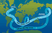
Ocean variability
The oceanOcean
An ocean is a major body of saline water, and a principal component of the hydrosphere. Approximately 71% of the Earth's surface is covered by ocean, a continuous body of water that is customarily divided into several principal oceans and smaller seas.More than half of this area is over 3,000...
is a fundamental part of the climate system, some changes in it occurring at longer timescales than in the atmosphere,
massing hundreds of times more and having very high thermal inertia
Volumetric heat capacity
Volumetric heat capacity , also termed volume-specific heat capacity, describes the ability of a given volume of a substance to store internal energy while undergoing a given temperature change, but without undergoing a phase change...
(such as the ocean depths still lagging today in temperature adjustment from the Little Ice Age
Little Ice Age
The Little Ice Age was a period of cooling that occurred after the Medieval Warm Period . While not a true ice age, the term was introduced into the scientific literature by François E. Matthes in 1939...
).
Short-term fluctuations (years to a few decades) such as the El Niño-Southern Oscillation
El Niño-Southern Oscillation
El Niño/La Niña-Southern Oscillation, or ENSO, is a quasiperiodic climate pattern that occurs across the tropical Pacific Ocean roughly every five years...
, the Pacific decadal oscillation
Pacific decadal oscillation
The Pacific Decadal Oscillation is a pattern of Pacific climate variability that shifts phases on at least inter-decadal time scale, usually about 20 to 30 years. The PDO is detected as warm or cool surface waters in the Pacific Ocean, north of 20° N...
, the North Atlantic oscillation
North Atlantic oscillation
The North Atlantic oscillation is a climatic phenomenon in the North Atlantic Ocean of fluctuations in the difference of atmospheric pressure at sea level between the Icelandic low and the Azores high. Through east-west oscillation motions of the Icelandic low and the Azores high, it controls the...
, and the Arctic oscillation
Arctic oscillation
The Arctic oscillation or Northern Annular Mode/Northern Hemisphere Annular Mode is an index of the dominant pattern of non-seasonal sea-level pressure variations north of 20N latitude, and it is characterized by pressure anomalies of one sign in the Arctic with the opposite anomalies centered...
, represent climate variability rather than climate change. On longer time scales, alterations to ocean processes such as thermohaline circulation
Thermohaline circulation
The term thermohaline circulation refers to a part of the large-scale ocean circulation that is driven by global density gradients created by surface heat and freshwater fluxes....
play a key role in redistributing heat by carrying out a very slow and extremely deep movement of water
Water
Water is a chemical substance with the chemical formula H2O. A water molecule contains one oxygen and two hydrogen atoms connected by covalent bonds. Water is a liquid at ambient conditions, but it often co-exists on Earth with its solid state, ice, and gaseous state . Water also exists in a...
, and the long-term redistribution of heat
Heat
In physics and thermodynamics, heat is energy transferred from one body, region, or thermodynamic system to another due to thermal contact or thermal radiation when the systems are at different temperatures. It is often described as one of the fundamental processes of energy transfer between...
in the world's oceans.
External forcing mechanisms
Orbital variations
Slight variations in Earth's orbitOrbit
In physics, an orbit is the gravitationally curved path of an object around a point in space, for example the orbit of a planet around the center of a star system, such as the Solar System...
lead to changes in the seasonal distribution of sunlight reaching the Earth's surface and how it is distributed across the globe. There is very little change to the area-averaged annually averaged sunshine; but there can be strong changes in the geographical and seasonal distribution. The three types of orbital variations are variations in Earth's eccentricity
Orbital eccentricity
The orbital eccentricity of an astronomical body is the amount by which its orbit deviates from a perfect circle, where 0 is perfectly circular, and 1.0 is a parabola, and no longer a closed orbit...
, changes in the tilt angle of Earth's axis of rotation
Axial tilt
In astronomy, axial tilt is the angle between an object's rotational axis, and a line perpendicular to its orbital plane...
, and precession
Precession
Precession is a change in the orientation of the rotation axis of a rotating body. It can be defined as a change in direction of the rotation axis in which the second Euler angle is constant...
of Earth's axis. Combined together, these produce Milankovitch cycles
Milankovitch cycles
Milankovitch theory describes the collective effects of changes in the Earth's movements upon its climate, named after Serbian civil engineer and mathematician Milutin Milanković, who worked on it during First World War internment...
which have a large impact on climate and are notable for their correlation to glacial
Glacial period
A glacial period is an interval of time within an ice age that is marked by colder temperatures and glacier advances. Interglacials, on the other hand, are periods of warmer climate within an ice age...
and interglacial periods, their correlation with the advance and retreat of the Sahara
Sahara
The Sahara is the world's second largest desert, after Antarctica. At over , it covers most of Northern Africa, making it almost as large as Europe or the United States. The Sahara stretches from the Red Sea, including parts of the Mediterranean coasts, to the outskirts of the Atlantic Ocean...
, and for their appearance
Cyclostratigraphy
Cyclostratigraphy is the study of astronomically forced climate cycles within sedimentary successions . Astronomical cycles are variations of the Earth's orbit around the sun due to the gravitational interaction with other masses within the solar system. Due to this cyclicity solar irradiation...
in the stratigraphic record
Geologic record
The geologic record in stratigraphy, paleontology and other natural sciences refers to the entirety of the layers of rock strata — deposits laid down in volcanism or by sediment deposition of weathering detritus including all its fossil content and the information it yields about the history...
.
The IPCC
IPCC
IPCC may refer to:*Intergovernmental Panel on Climate Change, of the United Nations*Independent Police Complaints Commission, of England and Wales*Irish Peatland Conservation Council...
notes that Milankovitch cycles drove the ice age cycles; CO2 followed temperature change "with a lag of some hundreds of years"; and that as a feedback amplified temperature change. The depths of the ocean have a lag time in changing temperature (thermal inertia on such scale). Upon seawater temperature change, the solubility of CO2 in the oceans changed, as well as other factors impacting air-sea CO2 exchange.
Solar output
Sun
The Sun is the star at the center of the Solar System. It is almost perfectly spherical and consists of hot plasma interwoven with magnetic fields...
is the predominant source for energy
Energy
In physics, energy is an indirectly observed quantity. It is often understood as the ability a physical system has to do work on other physical systems...
input to the Earth. Both long- and short-term variations in solar intensity are known to affect global climate.
Three to four billion years ago the sun emitted only 70% as much power as it does today. If the atmospheric composition had been the same as today, liquid water should not have existed on Earth. However, there is evidence for the presence of water on the early Earth, in the Hadean
Hadean
The Hadean is the geologic eon before the Archean. It started with the formation of the Earth about 4.7 Ga and ended roughly 3.8 Ga, though the latter date varies according to different sources. The name "Hadean" derives from Hades, Greek for "Underworld", referring to the "hellish"...
and Archean
Archean
The Archean , also spelled Archeozoic or Archæozoic) is a geologic eon before the Paleoproterozoic Era of the Proterozoic Eon, before 2.5 Ga ago. Instead of being based on stratigraphy, this date is defined chronometrically...
eons, leading to what is known as the faint young Sun paradox
Faint young Sun paradox
The faint young Sun paradox or problem describes the apparent contradiction between observations of liquid water early in the Earth's history and the astrophysical expectation that the Sun's output would be only 70% as intense during that epoch as it is during the modern epoch. The issue was raised...
. Hypothesized solutions to this paradox include a vastly different atmosphere, with much higher concentrations of greenhouse gas
Greenhouse gas
A greenhouse gas is a gas in an atmosphere that absorbs and emits radiation within the thermal infrared range. This process is the fundamental cause of the greenhouse effect. The primary greenhouse gases in the Earth's atmosphere are water vapor, carbon dioxide, methane, nitrous oxide, and ozone...
es than currently exist. Over the following approximately 4 billion years, the energy output of the sun increased and atmospheric composition changed. The Great Oxygenation Event
Great Oxygenation Event
The Great Oxygenation Event , also called the Oxygen Catastrophe or Oxygen Crisis or Great Oxidation, was the biologically induced appearance of free oxygen in Earth's atmosphere. This major environmental change happened around 2.4 billion years ago.Photosynthesis was producing oxygen both before...
-oxygenation of the atmosphere- around 2.4 billion years ago was the most notable alteration. Over the next five billion years the sun's ultimate death as it becomes a red giant
Red giant
A red giant is a luminous giant star of low or intermediate mass in a late phase of stellar evolution. The outer atmosphere is inflated and tenuous, making the radius immense and the surface temperature low, somewhere from 5,000 K and lower...
and then a white dwarf
White dwarf
A white dwarf, also called a degenerate dwarf, is a small star composed mostly of electron-degenerate matter. They are very dense; a white dwarf's mass is comparable to that of the Sun and its volume is comparable to that of the Earth. Its faint luminosity comes from the emission of stored...
will have large effects on climate, with the red giant phase possibly ending any life on Earth that survives until that time.
Solar output also varies
Solar variation
Solar variation is the change in the amount of radiation emitted by the Sun and in its spectral distribution over years to millennia. These variations have periodic components, the main one being the approximately 11-year solar cycle . The changes also have aperiodic fluctuations...
on shorter time scales, including the 11-year solar cycle
Solar cycle
The solar cycle, or the solar magnetic activity cycle, is a periodic change in the amount of irradiation from the Sun that is experienced on Earth. It has a period of about 11 years, and is one component of solar variation, the other being aperiodic fluctuations. Solar variation causes changes in...
and longer-term modulation
Modulation
In electronics and telecommunications, modulation is the process of varying one or more properties of a high-frequency periodic waveform, called the carrier signal, with a modulating signal which typically contains information to be transmitted...
s. Solar intensity variations are considered to have been influential in triggering the Little Ice Age
Little Ice Age
The Little Ice Age was a period of cooling that occurred after the Medieval Warm Period . While not a true ice age, the term was introduced into the scientific literature by François E. Matthes in 1939...
, and some of the warming observed from 1900 to 1950. The cyclical nature of the sun's energy output is not yet fully understood; it differs from the very slow change that is happening within the sun as it ages and evolves. Research indicates that solar variability has had effects including the Maunder Minimum
Maunder Minimum
The Maunder Minimum is the name used for the period roughly spanning 1645 to 1715 when sunspots became exceedingly rare, as noted by solar observers of the time....
from 1645 to 1715 A.D.
Anno Domini
and Before Christ are designations used to label or number years used with the Julian and Gregorian calendars....
, part of the Little Ice Age
Little Ice Age
The Little Ice Age was a period of cooling that occurred after the Medieval Warm Period . While not a true ice age, the term was introduced into the scientific literature by François E. Matthes in 1939...
from 1550 to 1850 A.D.
Anno Domini
and Before Christ are designations used to label or number years used with the Julian and Gregorian calendars....
which was marked by relative cooling and greater glacier extent than the centuries before and afterward. Some studies point toward solar radiation increases from cyclical sunspot activity affecting global warming, and climate may be influenced by the sum of all effects (solar variation
Solar variation
Solar variation is the change in the amount of radiation emitted by the Sun and in its spectral distribution over years to millennia. These variations have periodic components, the main one being the approximately 11-year solar cycle . The changes also have aperiodic fluctuations...
, anthropogenic radiative forcing
Radiative forcing
In climate science, radiative forcing is generally defined as the change in net irradiance between different layers of the atmosphere. Typically, radiative forcing is quantified at the tropopause in units of watts per square meter. A positive forcing tends to warm the system, while a negative...
s, etc.).
Interestingly, a 2010 study suggests, “that the effects of solar variability on temperature throughout the atmosphere may be contrary to current expectations.”
In an Aug 2011 Press Release, CERN
CERN
The European Organization for Nuclear Research , known as CERN , is an international organization whose purpose is to operate the world's largest particle physics laboratory, which is situated in the northwest suburbs of Geneva on the Franco–Swiss border...
announced the publication in the Nature
Nature (journal)
Nature, first published on 4 November 1869, is ranked the world's most cited interdisciplinary scientific journal by the Science Edition of the 2010 Journal Citation Reports...
journal the initial results from its CLOUD
CLOUD
Cosmics Leaving Outdoor Droplets or the CLOUD is an experimental facility being run at CERN by Jasper Kirkby to investigate the microphysics between galactic cosmic rays and aerosols under controlled conditions...
experiment. The results indicate that ionisation from cosmic rays significantly enhances aerosol formation in the presence of sulphuric acid and water, but in the lower atmosphere where ammonia is also required, this is insufficient to account for aerosol formation and additional trace vapours must be involved. The next step is to find more about these trace vapours, including whether they are of natural or human origin.
Volcanism
Volcanic eruptions release gases and particulatesParticulates
Particulates – also known as particulate matter , suspended particulate matter , fine particles, and soot – are tiny subdivisions of solid matter suspended in a gas or liquid. In contrast, aerosol refers to particles and/or liquid droplets and the gas together. Sources of particulate matter can be...
into the atmosphere. Eruption
Volcano
2. Bedrock3. Conduit 4. Base5. Sill6. Dike7. Layers of ash emitted by the volcano8. Flank| 9. Layers of lava emitted by the volcano10. Throat11. Parasitic cone12. Lava flow13. Vent14. Crater15...
s large enough to affect climate occur on average several times per century, and cause cooling (by partially blocking the transmission of solar radiation to the Earth's surface) for a period of a few years. The eruption of Mount Pinatubo
Mount Pinatubo
Mount Pinatubo is an active stratovolcano located on the island of Luzon, near the tripoint of the Philippine provinces of Zambales, Tarlac, and Pampanga. It is located in the Tri-Cabusilan Mountain range separating the west coast of Luzon from the central plains, and is west of the dormant and...
in 1991, the second largest terrestrial eruption of the 20th century (after the 1912 eruption of Novarupta
Novarupta
Novarupta, meaning "new eruption", is a volcano located on the Alaska Peninsula in Katmai National Park and Preserve, about southwest of Anchorage. Formed in 1912 during the largest volcanic eruption of the 20th century, Novarupta released 30 times the volume of magma as the 1980 eruption of...
) affected the climate substantially. Global temperatures decreased by about 0.5 °C (0.9 °F). The eruption of Mount Tambora
Mount Tambora
Mount Tambora is an active stratovolcano, also known as a composite volcano, on the island of Sumbawa, Indonesia. Sumbawa is flanked both to the north and south by oceanic crust, and Tambora was formed by the active subduction zone beneath it. This raised Mount Tambora as high as , making it...
in 1815 caused the Year Without a Summer
Year Without a Summer
The Year Without a Summer was 1816, in which severe summer climate abnormalities caused average global temperatures to decrease by about 0.4–0.7 °C , resulting in major food shortages across the Northern Hemisphere...
. Much larger eruptions, known as large igneous province
Large igneous province
A Large Igneous Province is an extremely large accumulation of igneous rocks—intrusive, extrusive, or both—in the earth's crust...
s, occur only a few times every hundred million years, but may cause global warming and mass extinctions.
Volcanoes are also part of the extended carbon cycle
Carbon cycle
The carbon cycle is the biogeochemical cycle by which carbon is exchanged among the biosphere, pedosphere, geosphere, hydrosphere, and atmosphere of the Earth...
. Over very long (geological) time periods, they release carbon dioxide from the Earth's crust and mantle, counteracting the uptake by sedimentary rocks and other geological carbon dioxide sink
Carbon dioxide sink
A carbon sink is a natural or artificial reservoir that accumulates and stores some carbon-containing chemical compound for an indefinite period. The process by which carbon sinks remove carbon dioxide from the atmosphere is known as carbon sequestration...
s. The US Geological Survey estimates are that volcanic emissions are at a much lower level than than the effects of current human activities, which generate 100-300 times the amount of carbon dioxide emitted by volcanoes. A review of published studies indicates that annual volcanic emissions of carbon dioxide, including amounts released from mid-ocean ridges, volcanic arcs, and hot spot volcanoes, are only the equivalent of 3 to 5 days of human caused output. The annual amount put out by human activities may be greater than the amount released by supererruptions
Supervolcano
A supervolcano is a volcano capable of producing a volcanic eruption with an ejecta volume greater than 1,000 cubic kilometers . This is thousands of times larger than most historic volcanic eruptions. Supervolcanoes can occur when magma in the Earth rises into the crust from a hotspot but is...
, the most recent of which was the Toba eruption
Toba catastrophe theory
The Toba supereruption was a supervolcanic eruption that occurred some time between 69,000 and 77,000 years ago at Lake Toba . It is recognized as one of the Earth's largest known eruptions...
in Indonesia 74,000 years ago.
Although volcanoes are technically part of the lithosphere, which itself is part of the climate system, the IPCC explicitly defines volcanism as an external forcing agent.
Plate tectonics
Over the course of millions of years, the motion of tectonic plates reconfigures global land and ocean areas and generates topography. This can affect both global and local patterns of climate and atmosphere-ocean circulation.The position of the continents determines the geometry of the oceans and therefore influences patterns of ocean circulation. The locations of the seas are important in controlling the transfer of heat and moisture across the globe, and therefore, in determining global climate. A recent example of tectonic control on ocean circulation is the formation of the Isthmus of Panama
Isthmus of Panama
The Isthmus of Panama, also historically known as the Isthmus of Darien, is the narrow strip of land that lies between the Caribbean Sea and the Pacific Ocean, linking North and South America. It contains the country of Panama and the Panama Canal...
about 5 million years ago, which shut off direct mixing between the Atlantic and Pacific Oceans. This strongly affected the ocean dynamics of what is now the Gulf Stream
Gulf Stream
The Gulf Stream, together with its northern extension towards Europe, the North Atlantic Drift, is a powerful, warm, and swift Atlantic ocean current that originates at the tip of Florida, and follows the eastern coastlines of the United States and Newfoundland before crossing the Atlantic Ocean...
and may have led to Northern Hemisphere ice cover. During the Carboniferous
Carboniferous
The Carboniferous is a geologic period and system that extends from the end of the Devonian Period, about 359.2 ± 2.5 Mya , to the beginning of the Permian Period, about 299.0 ± 0.8 Mya . The name is derived from the Latin word for coal, carbo. Carboniferous means "coal-bearing"...
period, about 300 to 360 million years ago, plate tectonics may have triggered large-scale storage of carbon and increased glaciation. Geologic evidence points to a "megamonsoonal" circulation pattern during the time of the supercontinent
Supercontinent
In geology, a supercontinent is a landmass comprising more than one continental core, or craton. The assembly of cratons and accreted terranes that form Eurasia qualifies as a supercontinent today.-History:...
Pangaea
Pangaea
Pangaea, Pangæa, or Pangea is hypothesized as a supercontinent that existed during the Paleozoic and Mesozoic eras about 250 million years ago, before the component continents were separated into their current configuration....
, and climate modeling suggests that the existence of the supercontinent was conducive to the establishment of monsoons.
The size of continents is also important. Because of the stabilizing effect of the oceans on temperature, yearly temperature variations are generally lower in coastal areas than they are inland. A larger supercontinent will therefore have more area in which climate is strongly seasonal than will several smaller continents or island
Island
An island or isle is any piece of sub-continental land that is surrounded by water. Very small islands such as emergent land features on atolls can be called islets, cays or keys. An island in a river or lake may be called an eyot , or holm...
s.
Human influences
In the context of climate variation, anthropogenic factors are human activities which affect the climate. The scientific consensus on climate changeScientific opinion on climate change
The predominant scientific opinion on climate change is that the Earth is in an ongoing phase of global warming primarily caused by an enhanced greenhouse effect due to the anthropogenic release of carbon dioxide and other greenhouse gases...
is "that climate is changing and that these changes are in large part caused by human activities,"
and it "is largely irreversible."
Of most concern in these anthropogenic factors is the increase in CO2 levels due to emissions from fossil fuel
Fossil fuel
Fossil fuels are fuels formed by natural processes such as anaerobic decomposition of buried dead organisms. The age of the organisms and their resulting fossil fuels is typically millions of years, and sometimes exceeds 650 million years...
combustion, followed by aerosols (particulate matter in the atmosphere) and cement
Cement
In the most general sense of the word, a cement is a binder, a substance that sets and hardens independently, and can bind other materials together. The word "cement" traces to the Romans, who used the term opus caementicium to describe masonry resembling modern concrete that was made from crushed...
manufacture. Other factors, including land use, ozone depletion
Ozone depletion
Ozone depletion describes two distinct but related phenomena observed since the late 1970s: a steady decline of about 4% per decade in the total volume of ozone in Earth's stratosphere , and a much larger springtime decrease in stratospheric ozone over Earth's polar regions. The latter phenomenon...
, animal agriculture and deforestation
Deforestation
Deforestation is the removal of a forest or stand of trees where the land is thereafter converted to a nonforest use. Examples of deforestation include conversion of forestland to farms, ranches, or urban use....
, are also of concern in the roles they play - both separately and in conjunction with other factors - in affecting climate, microclimate
Microclimate
A microclimate is a local atmospheric zone where the climate differs from the surrounding area. The term may refer to areas as small as a few square feet or as large as many square miles...
, and measures of climate variables.
Physical evidence for and examples of climatic change
Evidence for climatic change is taken from a variety of sources that can be used to reconstruct past climates. Reasonably complete global records of surface temperature are available beginning from the mid-late 19th century. For earlier periods, most of the evidence is indirect—climatic changes are inferred from changes in proxiesProxy (climate)
In the study of past climates is known as paleoclimatology, climate proxies are preserved physical characteristics of the past that stand in for direct measurements , to enable scientists to reconstruct the climatic conditions that prevailed during much of the Earth's history...
, indicators that reflect climate, such as vegetation
Vegetation
Vegetation is a general term for the plant life of a region; it refers to the ground cover provided by plants. It is a general term, without specific reference to particular taxa, life forms, structure, spatial extent, or any other specific botanical or geographic characteristics. It is broader...
, ice core
Ice core
An ice core is a core sample that is typically removed from an ice sheet, most commonly from the polar ice caps of Antarctica, Greenland or from high mountain glaciers elsewhere. As the ice forms from the incremental build up of annual layers of snow, lower layers are older than upper, and an ice...
s, dendrochronology
Dendrochronology
Dendrochronology or tree-ring dating is the scientific method of dating based on the analysis of patterns of tree-rings. Dendrochronology can date the time at which tree rings were formed, in many types of wood, to the exact calendar year...
, sea level change, and glacial geology.
Temperature measurements and proxies
The instrumental temperature recordInstrumental temperature record
The instrumental temperature record shows fluctuations of the temperature of the global land surface and oceans. This data is collected from several thousand meteorological stations, Antarctic research stations and satellite observations of sea-surface temperature. Currently, the longest-running...
from surface stations was supplemented by radiosonde balloons
Radiosonde
A radiosonde is a unit for use in weather balloons that measures various atmospheric parameters and transmits them to a fixed receiver. Radiosondes may operate at a radio frequency of 403 MHz or 1680 MHz and both types may be adjusted slightly higher or lower as required...
, extensive atmospheric monitoring by the mid-20th century, and, from the 1970s on, with global satellite data
Satellite temperature measurements
The temperature of the atmosphere at various altitudes as well as sea and land surface temperatures can be inferred from satellite measurements. Weather satellites do not measure temperature directly but measure radiances in various wavelength bands...
as well. The 18O/16O ratio in calcite and ice core samples used to deduce ocean temperature in the distant past
Oxygen isotope ratio cycle
Oxygen isotope ratio cycles are cyclical variations in the ratio of the abundance of oxygen with an atomic mass of 18 to the abundance of oxygen with an atomic mass of 16 present in some substances, such as polar ice or calcite in ocean core samples. The ratio is linked to water temperature of...
is an example of a temperature proxy method, as are other climate metrics noted in subsequent categories.
Historical and archaeological evidence
Climate change in the recent past may be detected by corresponding changes in settlement and agricultural patterns. Archaeological evidence, oral historyOral history
Oral history is the collection and study of historical information about individuals, families, important events, or everyday life using audiotapes, videotapes, or transcriptions of planned interviews...
and historical documents can offer insights into past changes in the climate. Climate change effects have been linked to the collapse of various civilizations.
Glaciers
GlacierGlacier
A glacier is a large persistent body of ice that forms where the accumulation of snow exceeds its ablation over many years, often centuries. At least 0.1 km² in area and 50 m thick, but often much larger, a glacier slowly deforms and flows due to stresses induced by its weight...
s are considered among the most sensitive indicators of climate change. Their size is determined by a mass balance
Mass balance
A mass balance is an application of conservation of mass to the analysis of physical systems. By accounting for material entering and leaving a system, mass flows can be identified which might have been unknown, or difficult to measure without this technique...
between snow input and melt output. As temperatures warm, glaciers retreat unless snow precipitation increases to make up for the additional melt; the converse is also true.
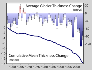
Glaciers grow and shrink due both to natural variability and external forcings. Variability in temperature, precipitation, and englacial and subglacial hydrology can strongly determine the evolution of a glacier in a particular season. Therefore, one must average over a decadal or longer time-scale and/or over a many individual glaciers to smooth out the local short-term variability and obtain a glacier history that is related to climate.
A world glacier inventory has been compiled since the 1970s, initially based mainly on aerial photographs and maps but now relying more on satellites. This compilation tracks more than 100,000 glaciers covering a total area of approximately 240,000 km2, and preliminary estimates indicate that the remaining ice cover is around 445,000 km2. The World Glacier Monitoring Service collects data annually on glacier retreat
Retreat of glaciers since 1850
The retreat of glaciers since 1850 affects the availability of fresh water for irrigation and domestic use, mountain recreation, animals and plants that depend on glacier-melt, and in the longer term, the level of the oceans...
and glacier mass balance
Glacier mass balance
Crucial to the survival of a glacier is its mass balance, the difference between accumulation and ablation . Climate change may cause variations in both temperature and snowfall, causing changes in mass balance. Changes in mass balance control a glacier's long term behavior and is the most...
From this data, glaciers worldwide have been found to be shrinking significantly, with strong glacier retreats in the 1940s, stable or growing conditions during the 1920s and 1970s, and again retreating from the mid 1980s to present.
The most significant climate processes since the middle to late Pliocene
Pliocene
The Pliocene Epoch is the period in the geologic timescale that extends from 5.332 million to 2.588 million years before present. It is the second and youngest epoch of the Neogene Period in the Cenozoic Era. The Pliocene follows the Miocene Epoch and is followed by the Pleistocene Epoch...
(approximately 3 million years ago) are the glacial and interglacial
Interglacial
An Interglacial period is a geological interval of warmer global average temperature lasting thousands of years that separates consecutive glacial periods within an ice age...
cycles. The present interglacial period (the Holocene
Holocene
The Holocene is a geological epoch which began at the end of the Pleistocene and continues to the present. The Holocene is part of the Quaternary period. Its name comes from the Greek words and , meaning "entirely recent"...
) has lasted about 11,700 years. Shaped by orbital variations
Milankovitch cycles
Milankovitch theory describes the collective effects of changes in the Earth's movements upon its climate, named after Serbian civil engineer and mathematician Milutin Milanković, who worked on it during First World War internment...
, responses such as the rise and fall of continental
Continental climate
Continental climate is a climate characterized by important annual variation in temperature due to the lack of significant bodies of water nearby...
ice sheets and significant sea-level changes helped create the climate. Other changes, including Heinrich event
Heinrich event
Heinrich events, first described by marine geologist Hartmut Heinrich, occurred during the last glacial period, or "ice age". During such events, armadas of icebergs broke off from glaciers and traversed the North Atlantic. The icebergs contained rock mass eroded by the glaciers, and as they...
s, Dansgaard–Oeschger events and the Younger Dryas
Younger Dryas
The Younger Dryas stadial, also referred to as the Big Freeze, was a geologically brief period of cold climatic conditions and drought between approximately 12.8 and 11.5 ka BP, or 12,800 and 11,500 years before present...
, however, illustrate how glacial variations may also influence climate without the orbital forcing
Orbital forcing
Orbital forcing is the effect on climate of slow changes in the tilt of the Earth's axis and shape of the orbit . These orbital changes change the total amount of sunlight reaching the Earth by up to 25% at mid-latitudes...
.
Glaciers leave behind moraine
Moraine
A moraine is any glacially formed accumulation of unconsolidated glacial debris which can occur in currently glaciated and formerly glaciated regions, such as those areas acted upon by a past glacial maximum. This debris may have been plucked off a valley floor as a glacier advanced or it may have...
s that contain a wealth of material—including organic matter, quartz, and potassium that may be dated—recording the periods in which a glacier advanced and retreated. Similarly, by tephrochronological
Tephrochronology
250px|thumb|right|Tephra horizons in south-central [[Iceland]]. The thick and light coloured layer at the height of the [[volcanologists]] hands is [[rhyolitic]] [[tephra]] from [[Hekla]]....
techniques, the lack of glacier cover can be identified by the presence of soil or volcanic tephra
Tephra
200px|thumb|right|Tephra horizons in south-central [[Iceland]]. The thick and light coloured layer at center of the photo is [[rhyolitic]] tephra from [[Hekla]]....
horizons whose date of deposit may also be ascertained.
Arctic sea ice loss
The decline in Arctic sea ice, both in extent and thickness, over the last several decades is further evidence for rapid climate change. Sea ice is frozen seawater that floats on the ocean surface. It covers millions of square miles in the polar regions, varying with the seasons. In the ArcticArctic
The Arctic is a region located at the northern-most part of the Earth. The Arctic consists of the Arctic Ocean and parts of Canada, Russia, Greenland, the United States, Norway, Sweden, Finland, and Iceland. The Arctic region consists of a vast, ice-covered ocean, surrounded by treeless permafrost...
, some sea ice remains year after year, whereas almost all Southern Ocean
Southern Ocean
The Southern Ocean comprises the southernmost waters of the World Ocean, generally taken to be south of 60°S latitude and encircling Antarctica. It is usually regarded as the fourth-largest of the five principal oceanic divisions...
or Antarctic sea ice melts away and reforms annually. Satellite observations show that Arctic sea ice is now declining at a rate of 11.5 percent per decade, relative to the 1979 to 2000 average.
Vegetation
A change in the type, distribution and coverage of vegetation may occur given a change in the climate. Some changes in climate may result in increased precipitation and warmth, resulting in improved plant growth and the subsequent sequestration of airborne CO2. A gradual increase in warmth in a region will lead to earlier flowering and fruiting times, driving a change in the timing of life cycles of dependent organisms. Conversely, cold will cause plant bio-cycles to lag. Larger, faster or more radical changes, however, may result in vegetation stress, rapid plant loss and desertification in certain circumstances. An example of this occurred during the Carboniferous Rainforest CollapseCarboniferous Rainforest Collapse
The Carboniferous Rainforest Collapse was an extinction event that occurred around 305 million years ago in the Carboniferous period). Vast coal forests covered the equatorial region of Euramerica...
(CRC), an extinction event 300 million years ago. At this time vast rainforests covered the equatorial region of Europe and America. Climate change devastated these tropical rainforests, abruptly fragmenting the habitat into isolated 'islands' and causing the extinction of many plant and animal species.
Satellite data available in recent decades indicates that global terrestrial net primary production increased by 6% from 1982 to 1999, with the largest portion of that increase in tropical ecosystems, then decreased by 1% from 2000 to 2009.
Pollen analysis
PalynologyPalynology
Palynology is the science that studies contemporary and fossil palynomorphs, including pollen, spores, orbicules, dinoflagellate cysts, acritarchs, chitinozoans and scolecodonts, together with particulate organic matter and kerogen found in sedimentary rocks and sediments...
is the study of contemporary and fossil palynomorph
Palynomorph
Palynomorph is the geological term used to describe a particle of a size between five and 500 micrometres, found in rock deposits and composed of organic material such as chitin, pseudochitin and sporopollenin...
s, including pollen
Pollen
Pollen is a fine to coarse powder containing the microgametophytes of seed plants, which produce the male gametes . Pollen grains have a hard coat that protects the sperm cells during the process of their movement from the stamens to the pistil of flowering plants or from the male cone to the...
. Palynology is used to infer the geographical distribution of plant species, which vary under different climate conditions. Different groups of plants have pollen
Pollen
Pollen is a fine to coarse powder containing the microgametophytes of seed plants, which produce the male gametes . Pollen grains have a hard coat that protects the sperm cells during the process of their movement from the stamens to the pistil of flowering plants or from the male cone to the...
with distinctive shapes and surface textures, and since the outer surface of pollen is composed of a very resilient material, they resist decay. Changes in the type of pollen found in different layers of sediment in lakes, bogs, or river deltas indicate changes in plant communities. These changes are often a sign of a changing climate. As an example, palynological studies have been used to track changing vegetation patterns throughout the Quaternary glaciation
Quaternary glaciation
Quaternary glaciation, also known as the Pleistocene glaciation, the current ice age or simply the ice age, refers to the period of the last few million years in which permanent ice sheets were established in Antarctica and perhaps Greenland, and fluctuating ice sheets have occurred elsewhere...
s and especially since the last glacial maximum
Last Glacial Maximum
The Last Glacial Maximum refers to a period in the Earth's climate history when ice sheets were at their maximum extension, between 26,500 and 19,000–20,000 years ago, marking the peak of the last glacial period. During this time, vast ice sheets covered much of North America, northern Europe and...
.
Precipitation
Past precipitation can be estimated in the modern era with the global network of precipitation gauges. Surface coverage over oceans and remote areas is relatively sparse, but, reducing reliance on interpolationInterpolation
In the mathematical field of numerical analysis, interpolation is a method of constructing new data points within the range of a discrete set of known data points....
, satellite data has been available since the 1970s. Quantification of climatological variation of precipitation in prior centuries and epochs is less complete but approximated using proxies such as marine sediments, ice cores, cave stalagmites, and tree rings.
Climatological temperatures substantially affect precipitation. For instance, during the Last Glacial Maximum
Last Glacial Maximum
The Last Glacial Maximum refers to a period in the Earth's climate history when ice sheets were at their maximum extension, between 26,500 and 19,000–20,000 years ago, marking the peak of the last glacial period. During this time, vast ice sheets covered much of North America, northern Europe and...
of 18,000 years ago, thermal-driven evaporation
Evaporation
Evaporation is a type of vaporization of a liquid that occurs only on the surface of a liquid. The other type of vaporization is boiling, which, instead, occurs on the entire mass of the liquid....
from the oceans onto continental landmasses was low, causing large areas of extreme desert, including polar desert
Polar desert
Polar deserts are areas with annual precipitation less than 250 millimeters and a mean temperature during the warmest month of less than 10°C and in the coldest month has a mean temperature of 56degress Polar deserts on Earth cover nearly 5 million square kilometers and are mostly hard bedrock or...
s (cold but with low rates of precipitation). In contrast, the world's climate was wetter than today near the start of the warm Atlantic Period of 8000 years ago.
Estimated global land precipitation increased by approximately 2% over the course of the 20th century, though the calculated trend varies if different time endpoints are chosen, complicated by ENSO
El Niño-Southern Oscillation
El Niño/La Niña-Southern Oscillation, or ENSO, is a quasiperiodic climate pattern that occurs across the tropical Pacific Ocean roughly every five years...
and other oscillations, including greater global land precipitation in the 1950s and 1970s than the later 1980s and 1990s despite the positive trend over the century overall.
Similar slight overall increase in global river runoff and in average soil moisture has been perceived.
Dendroclimatology
DendroclimatologyDendroclimatology
Dendroclimatology is the science of determining past climates from trees . Tree rings are wider when conditions favor growth, narrower when times are difficult. Other properties of the annual rings, such as maximum latewood density have been shown to be better proxies than simple ring width...
is the analysis of tree ring growth patterns to determine past climate variations. Wide and thick rings indicate a fertile, well-watered growing period, whilst thin, narrow rings indicate a time of lower rainfall and less-than-ideal growing conditions.
Ice cores
Analysis of ice in a core drilled from a ice sheetIce sheet
An ice sheet is a mass of glacier ice that covers surrounding terrain and is greater than 50,000 km² , thus also known as continental glacier...
such as the Antarctic ice sheet
Antarctic ice sheet
The Antarctic ice sheet is one of the two polar ice caps of the Earth. It covers about 98% of the Antarctic continent and is the largest single mass of ice on Earth. It covers an area of almost 14 million square km and contains 30 million cubic km of ice...
, can be used to show a link between temperature and global sea level variations. The air trapped in bubbles in the ice can also reveal the CO2 variations of the atmosphere from the distant past, well before modern environmental influences. The study of these ice cores has been a significant indicator of the changes in CO2 over many millennia, and continues to provide valuable information about the differences between ancient and modern atmospheric conditions.
Animals
Remains of beetleBeetle
Coleoptera is an order of insects commonly called beetles. The word "coleoptera" is from the Greek , koleos, "sheath"; and , pteron, "wing", thus "sheathed wing". Coleoptera contains more species than any other order, constituting almost 25% of all known life-forms...
s are common in freshwater and land sediments. Different species of beetles tend to be found under different climatic conditions. Given the extensive lineage of beetles whose genetic makeup has not altered significantly over the millennia, knowledge of the present climatic range of the different species, and the age of the sediments in which remains are found, past climatic conditions may be inferred.
Similarly, the historical abundance of various fish
Fish
Fish are a paraphyletic group of organisms that consist of all gill-bearing aquatic vertebrate animals that lack limbs with digits. Included in this definition are the living hagfish, lampreys, and cartilaginous and bony fish, as well as various extinct related groups...
species has been found to have a substantial relationships with observed climatic conditions . Changes in the primary productivity of autotrophs in the oceans can affect marine food webs.
Sea level change
Global sea level change for much of the last century has generally been estimated using tide gaugeTide gauge
A tide gauge is a device for measuring sea level and detecting tsunamis.Sensors continuously record the height of the water level with respect to a height reference surface close to the geoid...
measurements collated over long periods of time to give a long-term average. More recently, altimeter
Altimeter
An altimeter is an instrument used to measure the altitude of an object above a fixed level. The measurement of altitude is called altimetry, which is related to the term bathymetry, the measurement of depth underwater.-Pressure altimeter:...
measurements — in combination with accurately determined satellite
Satellite
In the context of spaceflight, a satellite is an object which has been placed into orbit by human endeavour. Such objects are sometimes called artificial satellites to distinguish them from natural satellites such as the Moon....
orbits — have provided an improved measurement of global sea level change. To measure sea levels prior to instrumental measurements, scientists have dated coral reef
Coral reef
Coral reefs are underwater structures made from calcium carbonate secreted by corals. Coral reefs are colonies of tiny living animals found in marine waters that contain few nutrients. Most coral reefs are built from stony corals, which in turn consist of polyps that cluster in groups. The polyps...
s that grow near the surface of the ocean, coastal sediments, marine terrace
Marine terrace
A marine terrace, coastal terrace, raised beach or perched coastline is a relatively flat, horizontal or gently inclined surface of marine origin, mostly an old abrasion platform which has been lifted out of the sphere of wave activity . Thus it lies above or under the current sea level, depending...
s, ooids in limestone
Limestone
Limestone is a sedimentary rock composed largely of the minerals calcite and aragonite, which are different crystal forms of calcium carbonate . Many limestones are composed from skeletal fragments of marine organisms such as coral or foraminifera....
s, and nearshore archaeological remains. The predominant dating methods used are uranium series
Uranium-thorium dating
Uranium-thorium dating, also called thorium-230 dating, uranium-series disequilibrium dating or uranium-series dating, is a radiometric dating technique commonly used to determine the age of calcium carbonate materials such as speleothem or coral...
and radiocarbon
Radiocarbon dating
Radiocarbon dating is a radiometric dating method that uses the naturally occurring radioisotope carbon-14 to estimate the age of carbon-bearing materials up to about 58,000 to 62,000 years. Raw, i.e. uncalibrated, radiocarbon ages are usually reported in radiocarbon years "Before Present" ,...
, with cosmogenic radionuclides being sometimes used to date terraces that have experienced relative sea level fall.
See also
- 4 Degrees and Beyond International Climate Conference4 Degrees and Beyond International Climate ConferenceThe 4 Degrees and Beyond International Climate Conference, subtitled Implications of a Global Climate Change of 4+ Degrees for People, Ecosystems and the Earth-system, was held 28-30 September 2009 at Oxford, United Kingdom. Implications of...
- Abrupt climate changeAbrupt climate changeAn abrupt climate change occurs when the climate system is forced to transition to a new state at a rate that is determined by the climate system itself, and which is more rapid than the rate of change of the external forcing...
and links therein - Attribution of recent climate changeAttribution of recent climate changeAttribution of recent climate change is the effort to scientifically ascertain mechanisms responsible for recent changes observed in the Earth's climate...
- Climate change in literatureClimate change in literatureAnthropogenic climate change is an emerging topic in literature, increasingly taken as a major theme or element of plot.-Non-fiction:An Inconvenient Truth: The Planetary Emergency of Global Warming and What We Can Do About It is a 2006 book by Al Gore released in conjunction with the film An...
- Climate change risk disparityClimate change risk disparityRisk is defined as the product of the probability of a certain event occuring and the consequence of said event happening.When it comes to Climate change, there are two very different sets of risk that humanity need to evaluate when choosing our climate change mitigation strategy.Scenario 1:...
- Geologic time scaleGeologic time scaleThe geologic time scale provides a system of chronologic measurement relating stratigraphy to time that is used by geologists, paleontologists and other earth scientists to describe the timing and relationships between events that have occurred during the history of the Earth...
- Temperature recordTemperature recordThe temperature record shows the fluctuations of the temperature of the atmosphere and the oceans through various spans of time. The most detailed information exists since 1850, when methodical thermometer-based records began. There are numerous estimates of temperatures since the end of the...
Climate of recent glaciations
- Bond eventBond eventBond events are North Atlantic climate fluctuations occurring every ≈1,470 ± 500 years throughout the Holocene. Eight such events have been identified, primarily from fluctuations in ice-rafted debris. Bond events may be the interglacial relatives of the glacial Dansgaard–Oeschger events, with a...
Climate of the past
- Snowball EarthSnowball EarthThe Snowball Earth hypothesis posits that the Earth's surface became entirely or nearly entirely frozen at least once, some time earlier than 650 Ma . Proponents of the hypothesis argue that it best explains sedimentary deposits generally regarded as of glacial origin at tropical...
- Ice ageIce ageAn ice age or, more precisely, glacial age, is a generic geological period of long-term reduction in the temperature of the Earth's surface and atmosphere, resulting in the presence or expansion of continental ice sheets, polar ice sheets and alpine glaciers...
s - Paleocene–Eocene Thermal Maximum
- Permo-CarboniferousPermo-CarboniferousThe Permo-Carboniferous refers to the time period including the latter parts of the Carboniferous and early part of the Permian period. Permo-Carboniferous rocks are in places not differentiated because of the presence of transitional fossils, and also where no conspicuous stratigraphic break is...
Glaciation
Recent climate
- AnthropoceneAnthropoceneThe Anthropocene is a recent and informal geologic chronological term that serves to mark the evidence and extent of human activities that have had a significant global impact on the Earth's ecosystems...
- Hardiness zoneHardiness zoneA hardiness zone is a geographically defined area in which a specific category of plant life is capable of growing, as defined by climatic conditions, including its ability to withstand the minimum temperatures of the zone...
- Holocene climatic optimumHolocene climatic optimumThe Holocene Climate Optimum was a warm period during roughly the interval 9,000 to 5,000 years B.P.. This event has also been known by many other names, including: Hypsithermal, Altithermal, Climatic Optimum, Holocene Optimum, Holocene Thermal Maximum, and Holocene Megathermal.This warm period...
- Medieval Warm PeriodMedieval Warm PeriodThe Medieval Warm Period , Medieval Climate Optimum, or Medieval Climatic Anomaly was a time of warm climate in the North Atlantic region, that may also have been related to other climate events around the world during that time, including in China, New Zealand, and other countries lasting from...
- Temperature record of the past 1000 yearsTemperature record of the past 1000 yearsThe temperature record of the 2nd millennium describes the reconstruction of temperatures since 1000 CE on the Northern Hemisphere, later extended back to 1 CE and also to cover the southern hemisphere. A reconstruction is needed because a reliable surface temperature record exists only since about...
Further reading
(pb: )..- Wagner, Frederic H., (ed.) Climate Change in Western North America: Evidence and Environmental Effects (2009). ISBN 978-0-87480-906-0
External links
- Climate Summit 2011 - London from the B4E Business for the EnvironmentB4E Business for the EnvironmentThe B4E Business for the Environment Summit is the leading international platform for dialogue and partnership solutions for the environment...
- Climate Change Resources from SourceWatchSourceWatchSourceWatch is an internet wiki site that is a collaborative project of the liberal Center for Media and Democracy...
- Climate Change from the UCB Libraries GovPubs
- Climate Change from the Met OfficeMet OfficeThe Met Office , is the United Kingdom's national weather service, and a trading fund of the Department for Business, Innovation and Skills...
(UK) - Global Climate Change from NASANASAThe National Aeronautics and Space Administration is the agency of the United States government that is responsible for the nation's civilian space program and for aeronautics and aerospace research...
(US) - Ocean Motion: Satellites Record Weakening North Atlantic Current
- Intergovernmental Panel on Climate Change (IPCC)
- United Nations University's 'Our World 2' Climate Change Video Briefs
- United Nations University's 'Our World 2' Indigenous voices on climate change films
- Climate Change Performance Index 2010
- Climate Library at Center for Ocean Solutions, Stanford University
- Climate Change: Coral Reefs on the Edge An online video presentation by Prof. Ove Hoegh-Guldberg, University of Auckland